Banda Aceh December 26th Earthquake monitored by GPS
|
|
|
- Evan Cook
- 5 years ago
- Views:
Transcription
, A. Socquet (1), B.A.C. Ambrosius (1), and P.")
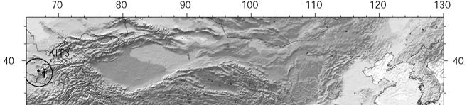
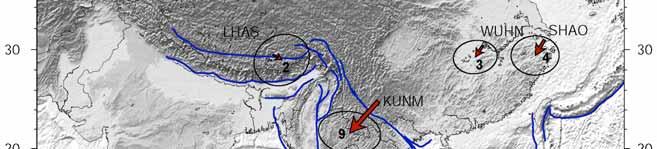
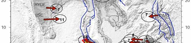
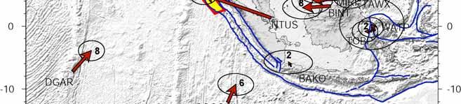
1 Banda Aceh December 26th Earthquake monitored by GPS C. Vigny (1), W.J.F. Simons (2), S. Abu (3), Chalermchon Satirapod (4), M. Hashizume (5), Sarayut Yousamran (6), C. Subarya (7), K. Omar (8), H.Z. Abidin (9), A. Socquet (1), B.A.C. Ambrosius (1), and P. Tregonning(10) (1) Laboratoire de Geologie, ENS-CNRS, France (2) DEOS, TU-Delft, The Netherlands (3) DSMM, Kuala Lumpur, Malaysia (4-5) Chulalongkorn University, Bangkok, Thailand (6) Royal Thai Survey Department (RTSD), Bangkok, Thailand (7) BAKOSURTANAL, Cibinong, Indonesia (8) University of Technology Malaysia (UTM), Malaysia (9) Institute of Technology Bandung (ITB), Bandung, Indonesia (10) University of Canberra, Australia SEAMERGES :
2 An Earthquake there was not unexpected GEODYSSEA + SEAMERGES GPS campaigns ~100 sites Sundaland platelet Socquet et al., 2003 Simons et al., 2004 Vigny Vigny et et al., al.,
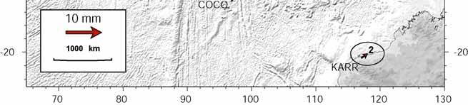
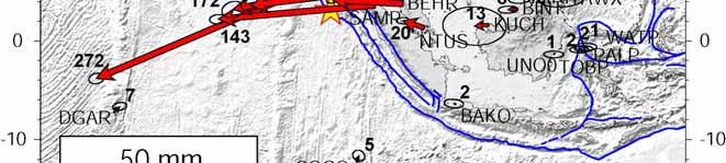
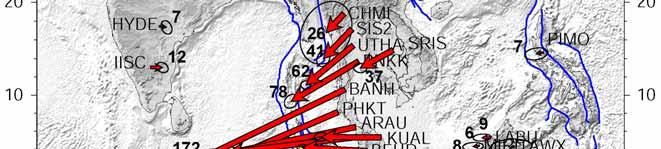
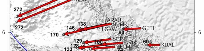
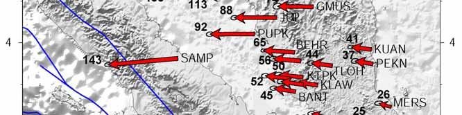
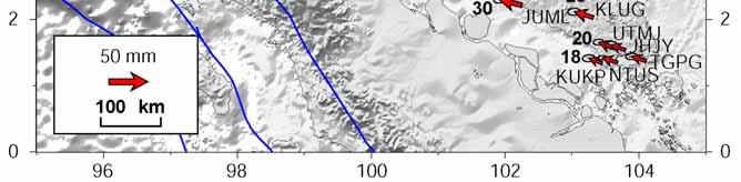
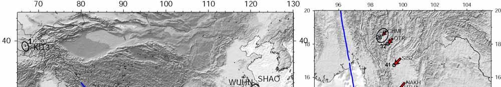
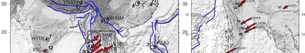
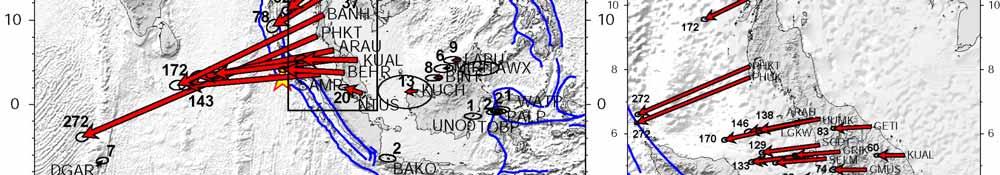
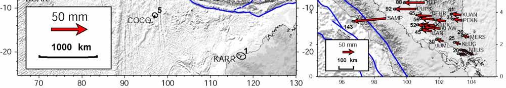
3 20 cm 2 cm
4


5 Thanks to ASEAN national institutions (DSMM, UTM, RTSD, CU) and international cooperation (ASEAN/EU/Japan) Permanent GPS networks do exist in Malaysia and Thailand
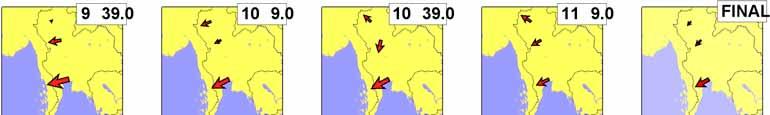
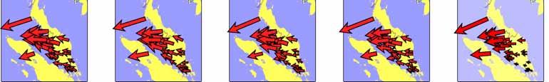
6

7
8

9

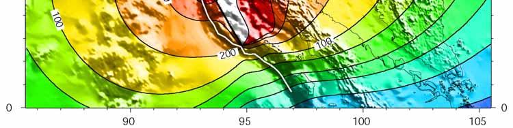
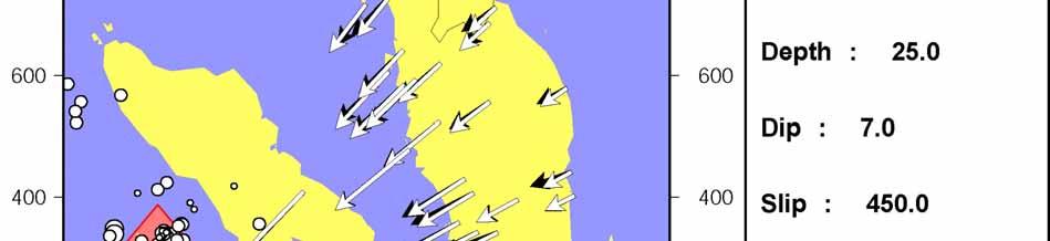
10 A rupture of 450 km length gives the reported magnitude (Mw=9.0) but it does not fit the observed deformation

11 A rupture of 1000 km length is required to fit far field deformation it corresponds to a larger magnitude Mw=9.2

12 Curvature of the trench must be taken into account to fit observed directions in Northern Malaysia


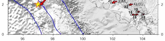
13 Best fit model 1/ rupture length = 1200 km Northward propagation from the epicenter 2/ heterogeneous slip - Almost no slip in the south - Patch of very large slip at..the northern tip of Sumatra..(in front of Phuket), 200 km..north of the epicenter - Hardly any slip around..7 North 3/ deep slip USGS epicenter

14 Kinematic Solution epoch-by-epoch positioning of the GPS station show the co-seismic step

15 By the way : Ionospheric disturbancy In L1 In L2 Not In LC In LG
16 Kinematic (epoch-by-epoch) positioning of the GPS station show the co-seismic step and allow to determine the seismic wave arrival time
17 Assuming a velocity of 3.6 km/s for seismic waves relocation of the source of the seismic energy is needed to match and sort arrival times at stations Again, a relocation of 200 km to the north is requested
18
19
20

21 Indication of source directivity is pointed by larger rise times at northern stations
22 No pre-seismic motion was detected. Post Seismic deformation will go on for years and may be for decades
23 Modification of seismic hazard in the area There is a higher risk of a near future events in the vicinity 1/ further South on the subduction 26 December March 2005


24 Nias Earthquake of March 28th
25
 but closer to cities 1/ further South on the subduction 2/ further North on the subduction 3/ on the Great Sumatran Fault 4/ on the Sagaing")
26 Modification of seismic hazard in the area 1 big or 2 small? There is a higher risk of a near future event 26 December 2004 Mw March 2005 Mw 8.7 When? Mw 9? Smaller (Mw<8) but closer to cities 1/ further South on the subduction 2/ further North on the subduction 3/ on the Great Sumatran Fault 4/ on the Sagaing fault
27 References Thanks and appreciations are extended to the different national agencies and universities (DSMM, RTSD, BAKOSURTANAL, UTM, CU) for sharing their regional GPS data in the framework of the SEAMERGES project Our sympathy goes to the family and relatives of the Phuket station operator who lost her life in the Tsunami disaster. Monitoring of the December 26th 2004 mega-thrust earthquake in SE Asias by GPS Vigny, et al., Geophysical Research abstracts, trans. EGU, EGU05-A-10732, 2005 Insight into the 2004 Sumatra-Andaman earthquake from GPS measurements in southeast Asia Vigny, et al., Nature, vol 436,14/07/05, pp ,doi: /nature03937, 2005
Report on Banda Aceh mega-thrust earthquake, December 26, 2004
 Report on Banda Aceh mega-thrust earthquake, December 26, 2004 Prepared January 7 th 2005 by C. Vigny, on behalf of the SEAMERGES (*) participants On the morning of December 26 th in SE Asia, 30 km below
Report on Banda Aceh mega-thrust earthquake, December 26, 2004
 Report on Banda Aceh mega-thrust earthquake, December 26, 2004 Prepared January 7 th 2005 by C. Vigny, on behalf of the SEAMERGES (*) participants On the morning of December 26 th, 2004 in SE Asia, 30
Change of Strain Rate in Thailand after the 26 December 2004 and 28 March 2005 Earthquakes Using GPS Measurements
 KSCE Journal of Civil Engineering (010) 14():15-0 DOI 10.1007/s105-010-015-4 Surveying and Geo-Spatial Information Engineering www.springer.com/105 Change of Strain Rate in Thailand after the 6 December
Insight into the 2004 Sumatra Andaman earthquake from GPS measurements in southeast Asia
 Vol 436 14 July 2005 doi:10.1038/nature03937 ARTICLES Insight into the 2004 Sumatra Andaman earthquake from GPS measurements in southeast Asia C. Vigny 1, W. J. F. Simons 2, S. Abu 3, Ronnachai Bamphenyu
The Earthquake of Padang, Sumatra of 30 September 2009 scientific information and update
 The Earthquake of Padang, Sumatra of 30 September 2009 scientific information and update 01-October-2009 Christophe Vigny Directeur de recherches at CNRS Laboratoire de Géologie Geoscience Dept. Of ENS,
On the Development and Implementations of the New Semi-Dynamic Datum for Indonesia
 On the Development and Implementations of the New Semi-Dynamic Datum for Indonesia Susilo SUSILO, Hasanuddin Z. ABIDIN, Irwan MEILANO, Benyamin SAPIIE, Indonesia Key words: geodetic datum, reference frames,
Lessons from the 2004 Sumatra earthquake and the Asian tsunami
 Lessons from the 2004 Sumatra earthquake and the Asian tsunami Kenji Satake National Institute of Advanced Industrial Science and Technology Outline 1. The largest earthquake in the last 40 years 2. Tsunami
News Release December 30, 2004 The Science behind the Aceh Earthquake
 News Release December 30, 2004 The Science behind the Aceh Earthquake PASADENA, Calif. - Kerry Sieh, the Robert P. Sharp Professor of Geology at the California Institute of Technology and a member of Caltech's
THE EFFECT OF THE LATEST SUMATRA EARTHQUAKE TO MALAYSIAN PENINSULAR
 JURNAL KEJURUTERAAN AWAM (JOURNAL OF CIVIL ENGINEERING) Vol. 15 No. 2, 2002 THE EFFECT OF THE LATEST SUMATRA EARTHQUAKE TO MALAYSIAN PENINSULAR Assoc. Prof. Dr. Azlan Adnan Hendriyawan Structural Earthquake
Rapid Determination of Earthquake Magnitude using GPS for Tsunami Warning Systems: An Opportunity for IGS to Make a Difference
 Rapid Determination of Earthquake Magnitude using GPS for Tsunami Warning Systems: An Opportunity for IGS to Make a Difference Geoffrey Blewitt, 1 Corné Kreemer, 1 William C. Hammond, 1 Hans-Peter Plag,
Seismic Characteristics and Energy Release of Aftershock Sequences of Two Giant Sumatran Earthquakes of 2004 and 2005
 P-168 Seismic Characteristics and Energy Release of Aftershock Sequences of Two Giant Sumatran Earthquakes of 004 and 005 R. K. Jaiswal*, Harish Naswa and Anoop Singh Oil and Natural Gas Corporation, Vadodara
RELOCATION OF LARGE EARTHQUAKES ALONG THE SUMATRAN FAULT AND THEIR FAULT PLANES
 Synopses of Master Papers Bulletin of IISEE, 47, 25-30, 2013 RELOCATION OF LARGE EARTHQUAKES ALONG THE SUMATRAN FAULT AND THEIR FAULT PLANES Biana Rahayu Wulandari MEE11605 Supervisor: Nobuo HURUKAWA ABSTRACT
Earth-Oriented Space Research at TU-Delft
 Earth-Oriented Space Research at TU-Delft The contribution of DEOS to the South-East Asia: Mastering Environmental Research with Geodetic Space Techniques (SEAMERGES) project Kick-off meeting, Chulalongkorn
Report for 15th PCGIAP Meeting at 18th UNRCC-AP Working Group 1 Regional Geodesy
 Report for 15th PCGIAP Meeting at 18th UNRCC-AP Working Group 1 Regional Geodesy Chairman Shigeru Matsuzaka, Japan - shigeru@gsi.go.jp Vice Chairman Prof. Pengfei Cheng, China - chengpf@casm.ac.cn John
A decade of GPS in Southeast Asia: Resolving Sundaland motion and boundaries
 JOURNAL OF GEOPHYSICAL RESEARCH, VOL. 112,, doi:10.1029/2005jb003868, 2007 A decade of GPS in Southeast Asia: Resolving Sundaland motion and boundaries W. J. F. Simons, 1 A. Socquet, 1,9 C. Vigny, 2 B.
Building Disaster Resilience Community in Asia: Indonesian perspective
 Workshop C of the 7th Science Council of Asia (SCA) Conference Construction of Secure and Safe Society against Global Changes of Natural Disasters Okinawa, June 14 th, 2007 Building Disaster Resilience
GNH7/GG09/GEOL4002 EARTHQUAKE SEISMOLOGY AND EARTHQUAKE HAZARD
 Tectonics Lecture 10 Global Seismotectonics Rigid plate translation A Map of the World s Fracture Zones Magnetic anomalies and fracture zones form the basic building blocks for the construction of isochron
Tsunami Risk Mitigation Strategy for Thailand. Kjell Karlsrud Norwegian Geotechnical Institute (NGI)
") Tsunami Risk Mitigation Strategy for Thailand Kjell Karlsrud Norwegian Geotechnical Institute (NGI) The project was undertaken by NGI in cooperation with: NORSAR, UiB, UiO, NIBR, B.Heyerdahl, NTNU, Sintef
Tsunami Risk Mitigation Strategy for Thailand Kjell Karlsrud Norwegian Geotechnical Institute (NGI) The project was undertaken by NGI in cooperation with: NORSAR, UiB, UiO, NIBR, B.Heyerdahl, NTNU, Sintef
1.3 Short Review: Preliminary results and observations of the December 2004 Great Sumatra Earthquake Kenji Hirata
 1.3 Short Review: Preliminary results and observations of the December 2004 Great Sumatra Earthquake Kenji Hirata We give a brief review about observations and preliminary results regarding the 2004 great
Hazard and Vulnerability of Moderate Seismicity Regions
 Hazard and Vulnerability of Moderate Seismicity Regions presented by Professor Tso-Chien PAN Dean, College of Engineering Director, 25 October 2010 DRM GDLN Session on Earthquake Vulnerability Reduction
Modelling Subduction Zone Seismogenic Hazards in Southeast Asia for Seismic Hazard Assessments
 Modelling Subduction Zone Seismogenic Hazards in Southeast Asia for Seismic Hazard Assessments Vicki-Ann Dimas 1,2 and Gary Gibson 3 1. Corresponding Author. Seismic Hazard Analyst, Seismology Research
PADANG EARTHQUAKE, WEST SUMATRA ON MARCH 6, 2007
 PADANG EARTHQUAKE, WEST SUMATRA ON MARCH 6, 2007 EARTHQUAKE DETAILS The U. S. Geological Survey (USGS) informed a strong earthquake struck west Sumatra on Tuesday March 6, 2007 at 10:49 with a magnitude
Earthquakes Physical Geology 2017 Part 1: Exploring Earthquake distributions. Home butto California Earthquakes: 1) 2) 3) above
 2) 3) above") Earthquakes Physical Geology 2017 Adapted from a lab by Jennifer Wenner This lab is designed to give you experience exploring seismicity associated with different plate boundaries. You will examine seismograms
Earthquakes Physical Geology 2017 Adapted from a lab by Jennifer Wenner This lab is designed to give you experience exploring seismicity associated with different plate boundaries. You will examine seismograms
Inquiry: Sumatran earthquakes with GPS Earth Science Education
 Inquiry: Sumatran earthquakes with GPS Earth Science Education www.earthobservatory.sg Preparation: Before doing this investigation, complete two introductory investigations using GPS data from UNAVCO
Chapter 6. Strong Motions
 Chapter 6 Strong Motions In spite of the scale of this earthquake, there is unfortunately no strong motion record nearby the causative fault. The nearest seismograph is approximately 80km from the epicenter
STUDY ON TSUNAMIGENIC EARTHQUAKE CRITERIA FOR THE INDONESIAN TSUNAMI EARLY WARNING SYSTEM
 STUDY ON TSUNAMIGENIC EARTHQUAKE CRITERIA FOR THE INDONESIAN TSUNAMI EARLY WARNING SYSTEM Nanang T. Puspito 1 1 Geophysics Research Group, Faculty of Mining and Petroleum Engineering, Institute of Technology
A GLOBAL SURGE OF GREAT EARTHQUAKES FROM AND IMPLICATIONS FOR CASCADIA. Thorne Lay, University of California Santa Cruz
 A GLOBAL SURGE OF GREAT EARTHQUAKES FROM 2004-2014 AND IMPLICATIONS FOR CASCADIA Thorne Lay, University of California Santa Cruz Last 10 yrs - 18 great earthquakes: rate 1.8/yr; rate over preceding century
FOCAL MECHANISMS OF SUBDUCTION ZONE EARTHQUAKES ALONG THE JAVA TRENCH: PRELIMINARY STUDY FOR THE PSHA FOR YOGYAKARTA REGION, INDONESIA
 FOCAL MECHANISMS OF SUBDUCTION ZONE EARTHQUAKES ALONG THE JAVA TRENCH: PRELIMINARY STUDY FOR THE PSHA FOR YOGYAKARTA REGION, INDONESIA Myo Thant 1, Hiroshi Kawase 2, Subagyo Pramumijoyo 3, Heru Hendrayana
SOURCE INVERSION AND INUNDATION MODELING TECHNOLOGIES FOR TSUNAMI HAZARD ASSESSMENT, CASE STUDY: 2001 PERU TSUNAMI
 Paper No. TS-4-1 SOURCE INVERSION AND INUNDATION MODELING TECHNOLOGIES FOR TSUNAMI HAZARD ASSESSMENT, CASE STUDY: 2001 PERU TSUNAMI Bruno Adriano 1, Shunichi Koshimura 2 and Yushiro Fujii 3 ABSTRACT The
The Challenge of Earthquake Disaster in Indonesia. Hery Harjono Indonesian Institute of Sciences
 The Challenge of Earthquake Disaster in Indonesia Hery Harjono Indonesian Institute of Sciences * Presented at the J-Rapid Symposium, Sendai, Japan, March 6-7, 2013 INTRODUCTION The 2004 Giant Sumatran-Andaman
DATA BASE DEVELOPMENT OF ETA (ESTIMATED TIME OF ARRIVAL) FOR TSUNAMI DISASTER MITIGATION AT SOUTHWESTERN CITIES OF ACEH, INDONESIA
 FOR TSUNAMI DISASTER MITIGATION AT SOUTHWESTERN CITIES OF ACEH, INDONESIA") 6 th South China Sea Tsunami Workshop Nanyang Technology University, Singapore, 6-8 November 2013 DATA BASE DEVELOPMENT OF ETA (ESTIMATED TIME OF ARRIVAL) FOR TSUNAMI DISASTER MITIGATION AT SOUTHWESTERN
6 th South China Sea Tsunami Workshop Nanyang Technology University, Singapore, 6-8 November 2013 DATA BASE DEVELOPMENT OF ETA (ESTIMATED TIME OF ARRIVAL) FOR TSUNAMI DISASTER MITIGATION AT SOUTHWESTERN
Seismic Activity and Crustal Deformation after the 2011 Off the Pacific Coast of Tohoku Earthquake
 J-RAPID Symposium March 6-7, 2013 Seismic Activity and Crustal Deformation after the 2011 Off the Pacific Coast of Tohoku Earthquake Y. Honkura Tokyo Institute of Technology Japan Science and Technology
SEISMIC HAZARD ANALYSIS AND SEISMIC INPUT TO TSUNAMI MODELING FOR MICROZONATION OF MEURAXA DISTRICT CITY OF BANDA ACEH
 SEISMIC HAZARD ANALYSIS AND SEISMIC INPUT TO TSUNAMI MODELING FOR MICROZONATION OF MEURAXA DISTRICT CITY OF BANDA ACEH I W. Sengara 1, Hendarto 1, P. Sumiartha 1, H. Latief 1, S.B. Kusuma 1 and Munirwansjah
Numerical Simulation of the December 26,2004: Indian Ocean Tsunami
 Numerical Simulation of the December 26,2004: Indian Ocean Tsunami J. Asavanant, 1 M. Ioualalen, 2 N. Kaewbanjak, 1 S.T. Grilli, 3 P. Watts, 4 J.T. Kirby, 5 and F. Shi 5 1 Advanced Virtual and Intelligent
Overview of Consequences of the Tsunami in Thailand and Roles and Activities of the Department of Mineral Resources after the 26 December 2004 Tsunami
 Overview of Consequences of the Tsunami in Thailand and Roles and Activities of the after the 26 December 2004 Tsunami By Mr.Worawoot Tantiwanit, Thailand 1 Earthquake in NW of North Sumatra Island 580
STUDY ON APPROPRIATE MODELING OF TSUNAMIS IN MALAYSIA FOR RISK EVALUATION
 STUDY ON APPROPRIATE MODELING OF TSUNAMIS IN MALAYSIA FOR RISK EVALUATION Zaty Aktar binti Mokhtar* Supervisor: Fumihiko Imamura** MEE06025 Shunichi Koshimura** ABSTRACT In order to design a tsunami warning
This document is downloaded from DR-NTU, Nanyang Technological University Library, Singapore.
 This document is downloaded from DR-NTU, Nanyang Technological University Library, Singapore. Title Aceh Andaman earthquake : what happened and what's next? Author(s) Sieh, Kerry Citation Sieh, K. (2005).
JOURNAL OF GEOPHYSICAL RESEARCH, VOL. 112, B10402, doi: /2007jb004928, 2007
 JOURNAL OF GEOPHYSICAL RESEARCH, VOL. 112,, doi:10.1029/2007jb004928, 2007 Burma plate motion Vineet K. Gahalaut 1 and Kalpna Gahalaut 1 Received 5 January 2007; revised 11 June 2007; accepted 13 July
Originally published as:
 Originally published as: Henstock, T., McNeill, L., Dean, S., Barton, P., Tilmann, F., Rietbrock, A., Robinson, D., Gulick, S., Austin, J., Djajadihardja, Y., Natawidjaja, D., Permana, H., Bonneville,
crustal structure experiment beneath Wairarapa - Wellington area: results from SAHKE
 crustal structure experiment beneath Wairarapa - Wellington area: results from SAHKE Tim Stern and SAHKE team* * VUW, GNS, University of Southern California, University of Tokyo(Japan) SAHKE = Seismic
Global deformation from the great 2004 Sumatra-Andaman Earthquake observed by GPS: Implications for rupture process and global reference frame
 Earth Planets Space, 58, 141 148, 2006 Global deformation from the great 2004 Sumatra-Andaman Earthquake observed by GPS: Implications for rupture process and global reference frame Corné Kreemer, Geoffrey
Rapid determination of earthquake magnitude using GPS for tsunami warning systems
 Rapid determination of earthquake magnitude using GPS for tsunami warning systems Geoffrey Blewitt, 1 Corné Kreemer, 1 William C. Hammond, 1 Hans-Peter Plag, 1 Seth Stein, and Emile Okal The 6 December
Preparation for Future Earthquake and Tsunami Hazards: Lessons Learned from the 2004 Sumatra-Andaman Earthquake and the Asian Tsunami
 First International Conference of Aceh and Indian Ocean Studies Organized by Asia Research Institute, National University of Singapore & Rehabilitation and Construction Executing Agency for Aceh and Nias
Semi-Dynamic Datum of Indonesia
 Technical Seminar Reference Frame in Practice, Semi-Dynamic Datum of Indonesia H.Z. Abidin, A.B. Wijanarto, S.T. Wibowo, Susilo, J. Efendi Geospatial Information Agency, Indonesia (BIG) Sponsors: Page
DETERMINATION OF SLIP DISTRIBUTION OF THE 28 MARCH 2005 NIAS EARTHQUAKE USING JOINT INVERSION OF TSUNAMI WAVEFORM AND GPS DATA
 Synopses of Master Papers Bulletin of IISEE, 47, 115-10, 013 DETERMINATION OF SLIP DISTRIBUTION OF THE 8 MARCH 005 NIAS EARTHQUAKE USING JOINT INVERSION OF TSUNAMI WAVEFORM AND GPS DATA Tatok Yatimantoro
On the Development and Implementations of the New Semi- Dynamic Datum for Indonesia
 On the Development and Implementations of the New Semi- Dynamic Datum for Indonesia SusiloSUSILO 1, HasanuddinZ. ABIDIN 2, IrwanMEILANO 2, Benyamin SAPEII 2 1) Center for Geodetic Control Network and Geodynamic,
TOWARDS THE IMPLEMENTATION OF SEMI-DYNAMIC DATUM FOR MALAYSIA
 TOWARDS THE IMPLEMENTATION OF SEMI-DYNAMIC DATUM FOR MALAYSIA N. S. Shariff, J. Gill, Z. M. Amin, K. M. Omar Faculty of Geoinformation and Real-Estate, Universiti Teknologi Malaysia, 81310 Skudai, Johor
Tsunami Physics and Preparedness. March 6, 2005 ICTP Public Information Office 1
 Tsunami Physics and Preparedness March 6, 2005 ICTP Public Information Office 1 What we do Provide world-class research facilities for scientists from developing world Foster advanced scientific research,
Coseismic Slip and Afterslip of the Great M w 9.15 Sumatra Andaman Earthquake of 2004
 Bulletin of the Seismological Society of America, Vol. 97, No. 1A, pp. S15 S173, January 007, doi: 10.1785/010050631 Coseismic Slip and Afterslip of the Great M w 9.15 Sumatra Andaman Earthquake of 004
COULOMB STRESS CHANGES DUE TO RECENT ACEH EARTHQUAKES
 COULOMB STRESS CHANGES DUE TO RECENT ACEH EARTHQUAKES Madlazim Physics Department, Faculty Mathematics and Sciences of Surabaya State University (UNESA) Jl. Ketintang, Surabaya 60231, Indonesia. e-mail:
The Scientific Value of High-Rate, Low-Latency GPS Data
 The Scientific Value of High-Rate, Low-Latency GPS Data by W.C. Hammond, B.A. Brooks, R. Bürgmann, T. Heaton, M. Jackson, A.R. Lowry, S. Anandakrishnan Recent and ongoing technical advances in uses of
28 th March 2005 magnitude 8.7 earthquake Northern Sumatra, Indonesia
 29 th March 2005 GAPResponse 28 th March 2005 magnitude 8.7 earthquake Northern Sumatra, Indonesia Russell Blong T: +61 2 8209 4288 F: +61 2 9241 2441 E: russell.blong@benfieldgroup.com Ben Miliauskas
Earthquakes 11/14/2014. Earthquakes Occur at All Boundaries. Earthquakes. Key Aspects of an Earthquake. Epicenter. Focus
 Earthquakes Earthquakes Caused by friction and movement between Earth s tectonic plates A release of force Often caused by a catch between two plates As plates slide by, they stick to each other When the
International Research Collaboration in Indonesia: LIPI as a special reference
 Workshop on Science & Technology Cooperation With Developing Countries on Global Issues. Tokyo, 8 October 2008 International Research Collaboration in Indonesia: LIPI as a special reference Hery Harjono
Malaysian Journal of Civil Engineering 22(1) : (2010) Malaysia
 : (2010) Malaysia") AN INVESTIGATION ON THE ATTENUATION CHARACTERISTICS OF DISTANT GROUND MOTIONS IN PENINSULAR MALAYSIA BY COMPARING VALUES OF RECORDED WITH ESTIMATED PGA AND PGV Sherliza Zaini Sooria 1*, Sumio Sawada 2,
AN INVESTIGATION ON THE ATTENUATION CHARACTERISTICS OF DISTANT GROUND MOTIONS IN PENINSULAR MALAYSIA BY COMPARING VALUES OF RECORDED WITH ESTIMATED PGA AND PGV Sherliza Zaini Sooria 1*, Sumio Sawada 2,
Source modeling of hypothetical Tokai-Tonankai-Nankai, Japan, earthquake and strong ground motion simulation using the empirical Green s functions
 Source modeling of hypothetical Tokai-Tonankai-Nankai, Japan, earthquake and strong ground motion simulation using the empirical Green s functions Y. Ishii & K. Dan Ohsaki Research Institute, Inc., Tokyo
NUMERICAL SIMULATIONS FOR TSUNAMI FORECASTING AT PADANG CITY USING OFFSHORE TSUNAMI SENSORS
 NUMERICAL SIMULATIONS FOR TSUNAMI FORECASTING AT PADANG CITY USING OFFSHORE TSUNAMI SENSORS Setyoajie Prayoedhie Supervisor: Yushiro FUJII MEE10518 Bunichiro SHIBAZAKI ABSTRACT We conducted numerical simulations
We have previously looked at artificial seismograms such as this one here.
 We have previously looked at artificial seismograms such as this one here. S P A realistic Seismic Record Each vertical line = 1 minute Each horizontal line = 15 minutes Seismic station PMM is in Parkfield,
The Mega-Earthquakes of Chile: Seismology and the Sounds of the Earth
 The Mega-Earthquakes of Chile: Seismology and the Sounds of the Earth Michael Wysession Department of Earth and Planetary Sciences Washington University, St. Louis, MO Puerto Montt, Chile, November 6,
Monitoring Coastal Change after the Tsunami in Thailand
 IOP Conference Series: Earth and Environmental Science OPEN ACCESS Monitoring Coastal Change after the Tsunami in Thailand To cite this article: W Pantanahiran 2014 IOP Conf. Ser.: Earth Environ. Sci.
Journal of Geophysical Research (Solid Earth) Supporting Information for
 Supporting Information for") Journal of Geophysical Research (Solid Earth) Supporting Information for Postseismic Relocking of the Subduction Megathrust Following the 2007 Pisco, Peru earthquake D.Remy (a), H.Perfettini (b), N.Cotte
Journal of Geophysical Research (Solid Earth) Supporting Information for Postseismic Relocking of the Subduction Megathrust Following the 2007 Pisco, Peru earthquake D.Remy (a), H.Perfettini (b), N.Cotte
Earthquake Hazards. Tsunami
 Earthquake Hazards Tsunami Review: What is an earthquake? Earthquake is the vibration (shaking) and/or displacement of the ground produced by the sudden release of energy. The point inside the Earth where
Developing fragility functions for tsunami damage estimation using the numerical model and satellite imagery
 Developing fragility functions for tsunami damage estimation using the numerical model and satellite imagery Shunichi KOSHIMURA 1 and Hideaki YANAGISAWA 2 1 Associate Professor, Disaster Control Research
The Size and Duration of the Sumatra-Andaman Earthquake from Far-Field Static Offsets
 The Size and Duration of the Sumatra-Andaman Earthquake from Far-Field Static Offsets P. Banerjee, 1 F. F. Pollitz, 2 R. Bürgmann 3 * 1 Wadia Institute of Himalayan Geology, Dehra Dun, 248001, India. 2
GEORED Project: GNSS Geodesy Network for Geodynamics Research in Colombia, South America. Héctor Mora-Páez
 GEORED Project: GNSS Geodesy Network for Geodynamics Research in Colombia, South America. Héctor Mora-Páez Colombian Geological Survey UNAVCO SCIENCE MEETING Feb 27 March 1, 2012 Boulder, CO, TECTONIC
Predicting of Tsunami Inundation Area based on Propagation and Runup Numerical Model in Pacitan City
 Predicting of Tsunami Inundation Area based on Propagation and Runup Numerical Model in Pacitan City 1 Agus Suharyanto, 1 Alwafi Pujiraharjo, 2 Adipandang Yudono, 3 Keisuke Murakami, and 3 Chikashi Deguchi
2013 UC Ship Funds Proposal: Multi-frequency Imaging of the Sunda Megathrust (MIST) Summary 1. Objective 2. Scientific Rationale
 Summary 1. Objective 2. Scientific Rationale") 2013 UC Ship Funds Proposal: Multi-frequency Imaging of the Sunda Megathrust (MIST) Diego Melgar, Emmanuel Garcia, Samer Naif and Robert Petersen Institute of Geophysics and Planetary Physics Scripps Institution
2013 UC Ship Funds Proposal: Multi-frequency Imaging of the Sunda Megathrust (MIST) Diego Melgar, Emmanuel Garcia, Samer Naif and Robert Petersen Institute of Geophysics and Planetary Physics Scripps Institution
Current tsunami research activities in the Philippines
 DOST PHIVOLCS Current tsunami research activities in the Philippines Graciano P. Yumul, Jr. 1,2, Carla B. Dimalanta 1 and Bart Bautista 3 1 National Institute of Geological Sciences, University of the
5-31. Cambodia. Vietnam. South China S ea. Malaysia. Kuala L umpur. Singapore. Kalimantan. Sunda S trait. Jakarta. Java 98E. Sumatra. Pini.
 5-31 Ridge Ninetyeast 52mm/yr Wharton For e S umatran Ridge Indian Andaman Sea arc 1861 Burma Ridge 1833 Thailand Sumatran Sliver Subduction Southeast Asian P late Malaysia Fault P Cambodia Kuala L umpur
A search for seismic radiation from late slip for the December 26, 2004 Sumatra-Andaman (M w = 9.15) earthquake
 earthquake") Click Here for Full Article GEOPHYSICAL RESEARCH LETTERS, VOL. 33, L18305, doi:10.1029/2006gl027286, 2006 A search for seismic radiation from late slip for the December 26, 2004 Sumatra-Andaman (M w =
Click Here for Full Article GEOPHYSICAL RESEARCH LETTERS, VOL. 33, L18305, doi:10.1029/2006gl027286, 2006 A search for seismic radiation from late slip for the December 26, 2004 Sumatra-Andaman (M w =
The seismotectonic significance of the seismic swarm in the Brabant Massif (Belgium)
") The seismotectonic significance of the 2008-2010 seismic swarm in the Brabant Massif (Belgium) Koen VAN NOTEN, Thomas LECOCQ, Thierry CAMELBEECK Seismology-Gravimetry, Royal Observatory of Belgium, Brussels,
The seismotectonic significance of the 2008-2010 seismic swarm in the Brabant Massif (Belgium) Koen VAN NOTEN, Thomas LECOCQ, Thierry CAMELBEECK Seismology-Gravimetry, Royal Observatory of Belgium, Brussels,
Supplementary Material
 1 Supplementary Material 2 3 4 Interseismic, megathrust earthquakes and seismic swarms along the Chilean subduction zone (38-18 S) 5 6 7 8 9 11 12 13 14 1 GPS data set We combined in a single data set
Sendai Earthquake NE Japan March 11, Some explanatory slides Bob Stern, Dave Scholl, others updated March
 Sendai Earthquake NE Japan March 11, 2011 Some explanatory slides Bob Stern, Dave Scholl, others updated March 14 2011 Earth has 11 large plates and many more smaller ones. Plates are 100-200 km thick
Earthquake Hazards. Tsunami
 Earthquake Hazards Tsunami Review: What is an earthquake? Earthquake is the vibration (shaking) and/or displacement of the ground produced by the sudden release of energy. The point inside the Earth where
Three Fs of earthquakes: forces, faults, and friction. Slow accumulation and rapid release of elastic energy.
 Earthquake Machine Stick-slip: Elastic Rebound Theory Jerky motions on faults produce EQs Three Fs of earthquakes: forces, faults, and friction. Slow accumulation and rapid release of elastic energy. Three
Recent GNSS Developments and Reference Frame Issues in Turkey. Onur LENK and Bahadir AKTUĞ
 Recent GNSS Developments and Reference Frame Issues in Turkey Onur LENK and Bahadir AKTUĞ General Command of Mapping onur.lenk lenk@hgk.mil.tr 1/31 GPS STUDIES İN TURKEY date back to early 1990s geodynamics-oriented
GEOLOGY MEDIA SUITE Chapter 13
 UNDERSTANDING EARTH, SIXTH EDITION GROTZINGER JORDAN GEOLOGY MEDIA SUITE Chapter 13 Earthquakes 2010 W.H. Freeman and Company Three different types of seismic waves are recorded by seismographs Key Figure
Title. Author(s)Heki, Kosuke. CitationScience, 332(6036): Issue Date Doc URL. Type. File Information. A Tale of Two Earthquakes
Heki, Kosuke. CitationScience, 332(6036): Issue Date Doc URL. Type. File Information. A Tale of Two Earthquakes") Title A Tale of Two Earthquakes Author(s)Heki, Kosuke CitationScience, 332(6036): 1390-1391 Issue Date 2011-06-17 Doc URL http://hdl.handle.net/2115/48524 Type article (author version) File Information
Title A Tale of Two Earthquakes Author(s)Heki, Kosuke CitationScience, 332(6036): 1390-1391 Issue Date 2011-06-17 Doc URL http://hdl.handle.net/2115/48524 Type article (author version) File Information
AN ABNORMAL TSUNAMI GENERATED BY OCTOBER 25 th, 2010 MENTAWAI EARTHQUAKE
 AN ABNORMAL TSUNAMI GENERATED BY OCTOBER 25 th, 2010 MENTAWAI EARTHQUAKE Bambang Sunardi 1, Suci Dewi Anugrah 2, Thomas Hardy 1, Drajat Ngadmanto 1 1 Research and Development Center, Indonesia Meteorological
AN INTRODUCTION TO EARTHQUAKE GEODESY : Another Effort for Earthquake Hazard Monitoring
 AN INTRODUCTION TO EARTHQUAKE GEODESY : Another Effort for Earthquake Hazard Monitoring Andreas H., Irwan M., H.Z.Abidin, D. Darmawan, D.A. Sarsito, M. Gamal Geodesy Research Group Department of Geodetic
Earthquake Source. Kazuki Koketsu. Special Session: Great East Japan (Tohoku) Earthquake. Earthquake Research Institute, University of Tokyo
 Earthquake. Earthquake Research Institute, University of Tokyo") 2012/9/24 17:20-17:35 WCEE SS24.4 Special Session: Great East Japan (Tohoku) Earthquake Earthquake Source Kazuki Koketsu Earthquake Research Institute, University of Tokyo 1 Names and features of the earthquake
2012/9/24 17:20-17:35 WCEE SS24.4 Special Session: Great East Japan (Tohoku) Earthquake Earthquake Source Kazuki Koketsu Earthquake Research Institute, University of Tokyo 1 Names and features of the earthquake
Mw 7.8, Southwest of Sumatra, Indonesia Wed, 2 March 2016 at 12:49:48 UTC M /03/03
 Earthquake overview AFGHANISTA N PAKISTA N INDIA A moment magnitude (Mw) 7.8 earthquake struck in South West, Indonesia. The epicentre was centered about 800 km West South West of Padang, Sumatra province,
Usability of the Next Generation Attenuation Equations for Seismic Hazard Assessment in Malaysia
 Azlan Adnan, Patrick Liq Yee Tiong, Yue Eng Chow/ International Journal of Engineering Vol. 2 Issue 1, Jan-Feb 212, pp.639-644 Usability of the Next Generation Attenuation Equations for Seismic Hazard
Coseismic Slip Distributions of the 26 December 2004 Sumatra Andaman and 28 March 2005 Nias Earthquakes from GPS Static Offsets
 Bulletin of the Seismological Society of America, Vol. 97, No. 1A, pp. S86 S102, January 2007, doi: 10.1785/0120050609 E Coseismic Slip Distributions of the 26 December 2004 Sumatra Andaman and 28 March
Earthquakes. Earthquake Magnitudes 10/1/2013. Environmental Geology Chapter 8 Earthquakes and Related Phenomena
 Environmental Geology Chapter 8 Earthquakes and Related Phenomena Fall 2013 Northridge 1994 Kobe 1995 Mexico City 1985 China 2008 Earthquakes Earthquake Magnitudes Earthquake Magnitudes Richter Magnitude
The challenge of risk communication how risk communication is the key to triggering action: Experiences from the Philippines and PNG
 The challenge of risk communication how risk communication is the key to triggering action: Experiences from the Philippines and PNG Dr Andrew Jones on behalf of the Regional Development Group and partners
Indian Ocean Tsunami Warning System: Example from the 12 th September 2007 Tsunami
 Indian Ocean Tsunami Warning System: Example from the 12 th September 2007 Tsunami Charitha Pattiaratchi 1 Professor of Coastal Oceanography, The University of Western Australia Email: chari.pattiaratchi@uwa.edu.au
Reconstruction of Subsurface Structures from Ambient Seismic Noise in Jakarta Area
 Reconstruction of Subsurface Structures from Ambient Seismic Noise in Jakarta Area Sri Widiyantoro 1 Andri Dian Nugraha 1 Zulfakriza 2 Bayu Pranata 3 1 Global Geophysics Research Group, Faculty of Mining
Seismic Hazard characterization study using an earthquake source with Probabilistic Seismic Hazard Analysis (PSHA) method in the Northern of Sumatra
 method in the Northern of Sumatra") Journal of Physics: Conference Series PAPER OPEN ACCESS Seismic Hazard characterization study using an earthquake source with Probabilistic Seismic Hazard Analysis (PSHA) method in the Northern of Sumatra
Journal of Physics: Conference Series PAPER OPEN ACCESS Seismic Hazard characterization study using an earthquake source with Probabilistic Seismic Hazard Analysis (PSHA) method in the Northern of Sumatra
Earthquake Hazards. Tsunami
 Earthquake Hazards Tsunami Measuring Earthquakes Two measurements that describe the power or strength of an earthquake are: Intensity a measure of the degree of earthquake shaking at a given locale based
SM2.1/GD2.7/NH5.8/TS8.4, Large Earthquake and Tsunami Activity (co-organized), 13:30 17:00, Room B3
, 13:30 17:00, Room B3") SM Seismology Orals and PICOs MO1, 08:30 10:00 MO2, 10:30 12:00 MOL, 12:15 13:15 MO3, 13:30 15:00 MO4, 15:30 17:00 TU1, 08:30 10:00 Monday, 08 April SM1.2/AS4.13, Research and Development in Nuclear Explosion
SM Seismology Orals and PICOs MO1, 08:30 10:00 MO2, 10:30 12:00 MOL, 12:15 13:15 MO3, 13:30 15:00 MO4, 15:30 17:00 TU1, 08:30 10:00 Monday, 08 April SM1.2/AS4.13, Research and Development in Nuclear Explosion
TSUNAMI HAZARD ASSESSMENT FOR THE CENTRAL COAST OF PERU USING NUMERICAL SIMULATIONS FOR THE 1974, 1966 AND 1746 EARTHQUAKES
 TSUNAMI HAZARD ASSESSMENT FOR THE CENTRAL COAST OF PERU USING NUMERICAL SIMULATIONS FOR THE 1974, 1966 AND 1746 EARTHQUAKES Sheila Yauri Supervisor: Yushiro FUJII MEE10521 Bunichiro SHIBAZAKI ABSTRACT
Rupture Dynamics of Large Earthquakes inferred from Hydroacoustic Data
 Rupture Dynamics of Large Earthquakes inferred from Hydroacoustic Data Catherine de Groot-Hedlin Scripps Institution of Oceanography University of California, San Diego Great Sumatra Earthquake (Boxing
Prof. Isaac Kerlow. Principal Investigator Art+Media Group Leader
 Prof. Isaac Kerlow Principal Investigator Art+Media Group Leader The EOS/AXA Partnership The EOS/AXA Partnership 1. AXA Chair for Natural Hazards 2. Living with Disaster Mission of the Earth Observatory
GPS Strain & Earthquakes Unit 4: GPS strain analysis examples Student exercise
 GPS Strain & Earthquakes Unit 4: GPS strain analysis examples Student exercise Example 1: Olympic Peninsula Name: Please complete the following worksheet to estimate, calculate, and interpret the strain
Rupture Characteristics of Major and Great (M w 7.0) Megathrust Earthquakes from : 1. Source Parameter Scaling Relationships
 Megathrust Earthquakes from : 1. Source Parameter Scaling Relationships") Journal of Geophysical Research Solid Earth Supporting Information for Rupture Characteristics of Major and Great (M w 7.0) Megathrust Earthquakes from 1990-2015: 1. Source Parameter Scaling Relationships
Journal of Geophysical Research Solid Earth Supporting Information for Rupture Characteristics of Major and Great (M w 7.0) Megathrust Earthquakes from 1990-2015: 1. Source Parameter Scaling Relationships
Two ways to think about the dynamics of earthquake ruptures
 Two ways to think about the dynamics of earthquake ruptures (1) In terms of friction (2) In terms of fracture mechanics Scholz describes conditions for rupture propagation (i.e. instability) via energy
Investigation of Sumatran Fault Aceh Segment derived from Magnetotelluric Data
 Investigation of Sumatran Fault Aceh Segment derived from Magnetotelluric Data Nurhasan 1, D. Sutarno 1, Y Ogawa 2, F. Kimata 3, D Sugiyanto 4 1 Physics Department, Bandung Institute of Technology, Bandung,
Collaborative researches and activities on water-related disasters in ASEAN countries
 Collaborative researches and activities on water-related disasters in ASEAN countries Anawat Suppasri Fumihiko Imamura Natt Leelawat suppasri@irides.tohoku.ac.jp http://www.tsunami.civil.tohoku.ac.jp/hokusai3/j/people/member/anawatto.html
Coseismic slip model
 Figure 3 - Preliminary highly smoothed model of coseismic slip for the 11 March UCL Institute for Risk & Disaster Reduction Magnitude 9.0 (JMA scale) earthquake Occurred at 02:46:23 pm local time near