MAKING LOCATION MATTER
|
|
|
- Delphia Greene
- 5 years ago
- Views:
Transcription

1 MAKING LOCATION MATTER Action to activate location data for people-centred policy CANBERRA ROUNDTABLE 18 OCTOBER 2017 DISCUSSION NOTES v6.0

2 Discussion overview and priority actions About the Roundtable The Department of Prime Minister & Cabinet, Australian Institute of Health & Welfare and the Cooperative Research Centre for Spatial Information jointly convened the roundtable event, bringing together a small, interdisciplinary group to consider the challenges and conditions for more effective decision-making through better use of location information. In response to the Location Matters draft white paper, the purpose of the roundtable discussion was to: Consider the key challenges highlighted in the report Validate and modify (if necessary) the proposed call-to-action initiatives outlined in the report Collectively determine effective mechanisms to mobilise the call-toaction initiatives. The challenges to be addressed The issue to be addressed is that the adoption of people-centred spatial information, and its use for decision-making and policy, is not being optimised indeed, it is still in its infancy according to the Location Matters white paper. In order to increase the rate of adoption of this type of data, a number of challenges were identified for review by roundtable participants: 1. the lack of awareness and advocacy of spatial information by policy makers 2. the lack of resolution and education about privacy and security of people-centred spatial information among spatial scientists, government, policy makers and the community 3. the lack of access to people-centred spatial data 4. the lack of tools for integrating, analysing and visualising new types of spatial data 5. the lack of examples and quantifiable metrics around the value of spatial information to build business cases. In discussion, the roundtable participants highlighted an additional challenge as follows: 6. The lack of awareness of policy development requirements by data analysts/providers (spatial or otherwise), including information needs and timeframes, ease of interpretation, implication to policy etc. Page 2
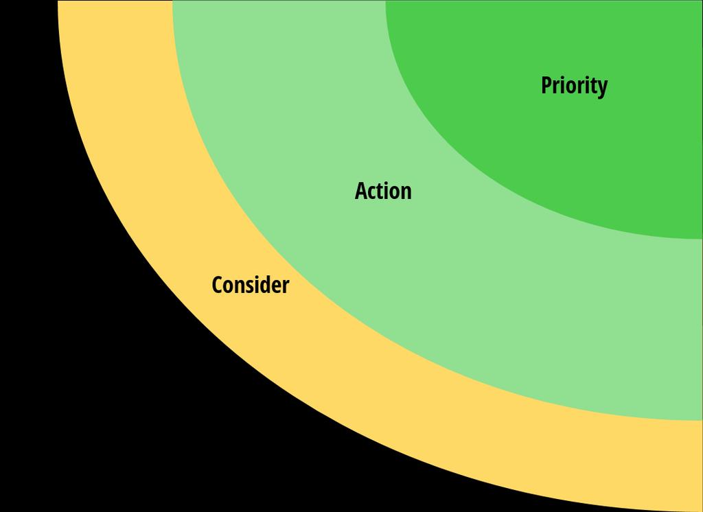
3 Discussion overview and priority actions Priority call-to-action initiatives From the Roundtable discussion, the following initiatives have been identified as priorities for action, reframed based on participant feedback: Improve and encourage collaboration between policymakers and spatial analysts Map, activate and target relevant networks to connect spatial information innovators with people-centric policy practitioners and domain experts Engage and inform with informative case studies about the use of people-centred spatial information in policy and decision-making. Advocate for spatial information through education and awareness-raising activities Comments on specific activities to mobilise effort for these initiatives, including additions or adjustments to the activities proposed in the Location Matters white paper are outlined in the latter half of this document. Methods to mobilise A series of underpinning principles and practices were identified to mobilise the impact of location data in policy settings. These include: Identify policy activity where spatial data can be on the agenda early Identify the live practical issues that can be addressed Focus on active policy considerations in front of the Heads of Agencies Often these issues are linked to relevant networks, committees and taskforces where the value of location can be reinforced through specific examples Also look for longer-term policy or strategy in development and use networks to build location intelligence into the design process in the early stages Spatial data technicians need to better understand the complexities and constraints of policy development Start with the problem The recommended approach is to first identify the problem that is to be addressed, then find the right people and the necessary resources to introduce location into the mix To get most traction, make location data relevant in this policy context The spatial sector needs to be able to clearly answer the question How can (spatial) data help with Cabinet Submissions (a complex process with many deadlines)? Connecting expertise The roundtable participants are a point of access and connection to a range of organisations, networks and channels to mobilise greater awareness, take-up and sensemaking of the value of location data Further consideration should be given to ways of bringing other sectors (private, non-government) into play Page 3
4 Location Matters review Positioning the Location Matters paper Suggestions to focus the positioning of the white paper included: Frame the recommendations more clearly for how the policy community can help spatial practitioners and vice versa more mutual action and impact Identify the role of other sectors in this space. For example, the private sector can bring useful case studies to expand the public sector focus (for example, banks and GPs) and also has a role to play in the development of tools and supporting capacity. Framing key concepts Validating call-to-action initiatives Roundtable participants considered proposed call-to-action initiatives via an impact/effort matrix process, and determined the following order of priority: Priority Action Improve and encourage collaboration between policy-makers and spatial analysts. Create a network of spatial information innovators. Publish informative case studies about the use of people-centred spatial information in policy and decision-making. Advocate for spatial information Two key issues emerged around the framing of the discussion: firstly around spatial data in the context of data in general, and secondly around the term people-centric. Improve access to quality people-centred spatial information Improve spatial knowledge in policy makers. On the spatial term: It was suggested that the framing of an opening conversation with policymakers is How will data help with the people-centred challenge you are faced with? In this way, spatial is not the lead message, it s about data and then introduce the geographic element Consider Improve the collection of quality people-centred spatial data Improve methods and understanding of privacy and security for people-centred spatial information On the people-centric term: There needs to be a clear definition of what is meant by peoplecentred spatial information: what is it about people-centred data that is different? It s about bringing information to bear on a particular problem, not marking particular data as people centric to the exclusion of others A potential reframing of people-centric in a data context is that it s about people at the high level and for people on a more personal level (both individual use and service delivery). Park Encourage the development of quality people-centred spatial products Work with the major publicly funded research programs to ensure inclusion of a spatial information and analytics strategy in the plans and policy recommendations. Improve spatial analysis methods. Improve the measurement and recording of the value of people-centred spatial information. Page 4
5

6
7 Comments on the call-to-action initiatives and proposed mobilisation mechanisms Improve the collection of quality people-centred spatial data Using a standardised approach (eg use GNAF) Promote and facilitate the collection of spatial data about people and about their location, that is, the environments through which they move. Promote collection of individual data; if data are aggregated, focus on small subgroups at local area scales and short time periods. Embrace new types of spatial data. Encourage standardisation of methods for collection and management of these data, including national and state spatial frameworks, consistent administration boundaries and alignment of these boundaries with people centric data. o Note that quality improves through use o Encourage investment in data sharing o Need to ensure the value proposition is based on the investment needed and also put in place up front agreements on how data is going to be used o Consideration of spatial in early planning stages of major policy and strategy work (eg NDIS) much harder to infuse downstream Improve methods and understanding of privacy and security for people-centred spatial information Give individuals a voice, bring them into the privacy discussion Improve acceptance of privacy and security How are the methods and understanding aimed at (audience)? Support current efforts to improve and standardise privacy and security of people-centred data and shared information. Encourage a broader understanding among the community about the use of their health and personal data in spatial analyses and mapping. o Re-frame the narrative to make it clear where data use is: For you (as an individual) For people like you (generic representation of a set of conditions) o People may be happy to share data if they understand the (mutual) value proposition Improve access to quality people-centred spatial information Clear direction to make data available Access by whom? Encourage the development of spatial data aggregation platforms to spatially empower analysts, decision-makers and communities. Support efforts to make data openly available, while adhering to privacy and security requirements. o It s less about the platforms (which already exist) but more about the allied policies about making them accessible o Discovery of data via standardisation and metadata Page 7
8 Encourage the development of quality people-centred spatial products Especially by non-government parties And tools and services Expand the availability and capability of software products for managing, visualising, analysing and communicating spatial information. This includes cloud-based products, mobile apps and other innovations. Continue to be a key partner in discussions about the way in which people-centred information is shared, including open platforms and public/private delivery. o Data as a service o Clearer articulation of the role in the private sector in making these available o Better understanding of requirements rather than a solution looking for a problem Improve spatial analysis methods. And capability Develop analytics tools that take account of the correlated nature of the data, missing observations, small subgroups and biases. This includes analysis of data collected at different spatial scales, data collected over space and time, data collected in real-time and new types of spatial data such as event data and crowd-sourced data. Work towards automation of these tools for general use. o Most important to identify and skill-up people who can use the tools and act as an interface between the technical and policy disciplines as well as with decision-makers o Building capability for people to use tools and analysis methods o Develop ways to introduce these methods into existing workflows and processes Improve the measurement and recording of the value of people-centred spatial information. to build (needed) case studies A triple bottom line approach to measuring the value of the various components of spatial information - formalisation and uptake of this approach, or a similar protocol o Engage with evaluation teams within the public sector to understand how evaluation and measurement works for policy and how spatial adds value to this as a common framework o Case studies and stories are still very useful to communicate even without metrics Page 8
9 Improve and encourage collaboration between policy-makers and spatial analysts. Bring together spatial information providers and policy makers in roundtable discussions to determine how to close this gap within organisations and at a national level. Establish discussion sessions among spatial data collectors, custodians and providers, ethicists, spatial analysts, decision-makers and policy makers, with the aim of sharing ideas and progress, disseminating knowledge, creating networks and developing showcase studies. Implement strategies to achieve this collaboration, for example by including a geospatial person in agencies data sections to spatially enable agency data and introduce spatially enabled analytical platforms. o Key starting points: For policymakers: Where do I go for this kind of expertise? For spatial practitioners: What s the policy that is being working on? o Targeted discussions rather than large presentations discuss relevant and specific exemplars Improve spatial knowledge in policy makers. And vice-versa Create opportunities for targeted education and information dissemination. Use the set of case studies presented in this paper to motivate knowledge transfer. Give clear ethical information about what is identifiable. Create a network of spatial information innovators. Create a network of early innovators of the use of spatial information for people-centred policy change. Australian agencies and businesses have the background, skills, tools and imperative to lead the way in translating spatial information to policy. o Infiltrate and connect existing networks, rather than create new networks. For example: Secretaries Data Group Deputy Secretaries Data Group Data Champions ABS Statistical Spatial Forum o Map the existing networks and outline roles/connections and purpose o Network between spatial innovators and others o Target younger professional networks o Consider horizontal and vertical networks o The participants in today s session are entry points into a network of organisations and individuals Page 9
10 Publish informative case studies about the use of people-centred spatial information in policy and decision-making. Engage and inform with case studies Collate, document and disseminate case studies that highlight the use of people-centred spatial information for decision making and policy. The studies should include an explicit assessment of the value-add of this information, including where possible the data, products and insights, and the resultant outcomes and policy changes. These studies will provide a pathway from innovation to general uptake among agencies, businesses and people-focused organisations. o It s about selling the narrative, which is most effectively done through user stories Advocate for spatial information Decision and policy makers can play a key role in actively supporting the collection, analysis and dissemination of spatial information. o Need pragmatic examples o There is an education component o Understand Ministerial narratives Work with the major publicly funded research programs to ensure inclusion of a spatial information and analytics strategy in the plans and policy recommendations. And operational government programs Work with o National Innovation and Science Agenda s 15 year rolling strategy o ANZLIC strategy including the Foundation Spatial Data Framework o 2026 Spatial Industry Transformation and Growth Agenda and its ten year rolling Action Plan o National Disability Strategy o National E-Health Strategy o Digital Economy Strategy o CRCSI o PSMA Page 10


11 Presentation & participation Workshop convenors Participating organisations For more information and follow-up Judi Dawton Senior Adviser, Spatial Data Policy, Data and Digital Branch, Policy Innovation & Projects Division Department of Prime Minister and Cabinet P: E: Paula Fievez Director Health Program CRCSI P: E: Australian Bureau of Statistics Australian Institute of Health and Welfare Business Aspect Cooperative Research Centre for Spatial Information CSIRO - Data61 Department of Employment Department of Health Department of Human Services Department of Industry, Innovation and Science Department of Social Services Department of the Prime Minister and Cabinet Geoscience Australia Institute of Public Administration Australia Queensland University of Technology Western Australia Department of Health Workshop presenters Distinguished Professor Kerrie Mengersen Queensland University of Technology Professor Jim Codde, CRCSI Health Program Science Director Facilitator Allison Hornery, Cofluence Page 11
Economic and Social Council
 United Nation E/C.20/2012/4/Add.1 Economic and Social Council Distr.: General 2 July 2012 Original: English Committee of Experts on Global Geospatial Information Management Second session New York, 13-15
Implementing the Sustainable Development Goals: The Role of Geospatial Technology and Innovation
 Fifth High Level Forum on UN Global Geospatial Information Management Implementing the Sustainable Development Goals: The Role of Geospatial Technology and Innovation 28-30 November 2017 Sheraton Maria
Economic and Social Council
 United Nations Economic and Social Council Distr.: General 18 July 2016 Original: English Committee of Experts on Global Geospatial Information Management Sixth session New York, 3-5 August 2016 Item 2
Ministry of Health and Long-Term Care Geographic Information System (GIS) Strategy An Overview of the Strategy Implementation Plan November 2009
 Strategy An Overview of the Strategy Implementation Plan November 2009") Ministry of Health and Long-Term Care Geographic Information System (GIS) Strategy An Overview of the Strategy Implementation Plan November 2009 John Hill, Health Analytics Branch Health System Information
Ministry of Health and Long-Term Care Geographic Information System (GIS) Strategy An Overview of the Strategy Implementation Plan November 2009 John Hill, Health Analytics Branch Health System Information
Briefing. H.E. Mr. Gyan Chandra Acharya
 Briefing by H.E. Mr. Gyan Chandra Acharya Under-Secretary-General and High Representative for the Least Developed Countries, Landlocked Developing Countries and Small Island Developing States Briefing
KUNMING FORUM ON UNITED NATIONS GLOBAL GEOSPATIAL INFORMATION MANAGEMENT CITIES OF THE FUTURE: SMART, RESILIENT
 KUNMING FORUM ON UNITED NATIONS GLOBAL GEOSPATIAL INFORMATION MANAGEMENT CITIES OF THE FUTURE: SMART, RESILIENT and SUSTAINABLE Yunnan Zhenzhuang Guest House, Kunming, China 10 12 May 2017 BACKGROUND CONCEPT
PUBLIC HEALTH ASSOCIATION OF AUSTRALIA Strategic Plan
 PUBLIC HEALTH ASSOCIATION OF AUSTRALIA Strategic Plan March 2017 20 Napier Close Deakin ACT Australia 2600 PO Box 319 Curtin ACT Australia 2605 Table of Contents Introduction... 2 Vision for a healthy
Policy and Legal Frameworks: The journey so far
 International Forum on Policy and Legal Frameworks for Geospatial Information, 18-19 October 2016, Kuala Lumpur, Malaysia Policy and Legal Frameworks: The journey so far Greg Scott Global Geospatial Information
Spatially Enabled Society
 International Seminar on Land Administration Trends and Issues in Asia and the Pacific Region Spatially Enabled Society Abbas Rajabifard Vice Chair PCGIAP-WG3 Vice-President (President Elect), GSDI Association
GOVERNMENT MAPPING WORKSHOP RECOVER Edmonton s Urban Wellness Plan Mapping Workshop December 4, 2017
 GOVERNMENT MAPPING WORKSHOP 12.4.17 RECOVER Edmonton s Urban Wellness Plan Mapping Workshop December 4, 2017 In July of 2017, City Council directed administration to develop RECOVER, Edmonton s Urban Wellness
Challenges and Successes in Sharing Geospatial Data in Africa
 Challenges and Successes in Sharing Geospatial Data in Africa 2018 GeoNode Summit Torino, Italy March 26-28, 2018 Bernard Justus Muhwezi Manager, Geo-Information Services Uganda Bureau of Statistics, Kampala,
2018/1 The integration of statistical and geospatial information. The Regional Committee of UN-GGIM: Americas:
 The following are the conclusions and recommendations of the Regional Committee of the United Nations on Global Geospatial Information Management for the Americas, during its Fifth Session, Thursday 8
THE ROLE OF GEOSPATIAL AT THE WORLD BANK
 THE ROLE OF GEOSPATIAL AT THE WORLD BANK INSPIRE Conference Barcelona, Spain September 26, 2016 Kathrine Kelm Senior Land Administration Specialist Global Land and Geospatial Unit The World Bank Group
Action Plan Spatial Industry Transformation and Growth Agenda
 2026 Spatial Industry Transformation and Growth Agenda Action Plan Summary of key initiatives and roadmap to drive the future of the Australian spatial sector 29 March 2017 For Release Foreword by Assistant
The Role of an Institutional Environment in Building Creative and Innovative Spatial Capacity
 The Role of an Institutional Environment in Building Creative and Innovative Spatial Capacity Olaf HEDBERG and Elizabeth THOMAS, Australia Key words: access, collaboration, frameworks, information sharing,
Future Proofing the Provision of Geoinformation: Emerging Technologies
 Future Proofing the Provision of Geoinformation: Emerging Technologies An Exchange Forum with the Geospatial Industry William Cartwright Chair JBGIS Second High Level Forum on Global Geospatial Information
Economic and Social Council
 United Nations Economic and Social Council Distr.: General 2 July 2012 E/C.20/2012/10/Add.1 Original: English Committee of Experts on Global Geospatial Information Management Second session New York, 13-15
A Modern Odyssey in Search of Relevance
 A Modern Odyssey in Search of Relevance Paul KELLY, Australia Key words: Capacity building, GIM, spatial data infrastructure. SUMMARY A modern country has a voracious appetite for spatial information.
UN-GGIM: Strengthening Geospatial Capability
 Fifth Plenary Meeting of UN-GGIM: Europe Brussels, 6-7 June 2018 UN-GGIM: Strengthening Geospatial Capability Walking the talk to leave no one behind Greg Scott, UN-GGIM Secretariat Environmental Statistics
have been a number of high level and expert reviews including the most recent, the Marmot review.
 QUESTIONS 5. Role of GPs and GP practices in public health: Are there additional ways in which we can ensure that GPs and GP practices will continue to play a key role in areas for which Public Health
Land Use in the context of sustainable, smart and inclusive growth
 Land Use in the context of sustainable, smart and inclusive growth François Salgé Ministry of sustainable development France facilitator EUROGI vice president AFIGéO board member 1 Introduction e-content+
A proposal for building an infrastructure for European geospatial statistics
 A proposal for building an infrastructure for European geospatial statistics Marie Haldorson, Statistics Sweden Ekkehard Petri, Eurostat What is geospatial statistics? The location, extent or spatial relations
Creating a Staff Development Plan with Esri
 Creating a Staff Development Plan with Esri Michael Green David Schneider Guest Presenter: Shane Feirer, University of California Esri UC 2014 Technical Workshop Agenda What is a Staff Development Plan?
Economic and Social Council
 United Nations E/CN.3/2019/31 Economic and Social Council Distr.: General 19 December 2018 Original: English Statistical Commission Fiftieth session 5-8 March 2019 Item 4(i) of the provisional agenda*
What s the problem? A Modern Odyssey in Search of Relevance. The search for relevance. Some current drivers for new services. Some Major Applications
 A Modern Odyssey in Search of Relevance FIG Working Week, Athens, 24 May 2004 Paul Kelly ANZLIC Executive Director The search for relevance 1. New expectations for spatial services 2. Are we ready to meet
A proposal for building an infrastructure for European geospatial statistics. Marie Haldorson, Statistics Sweden Ekkehard Petri, Eurostat
 A proposal for building an infrastructure for European geospatial statistics Marie Haldorson, Statistics Sweden Ekkehard Petri, Eurostat What is geospatial statistics? The location, extent or spatial relations
Empowered lives. Resilient nations. Data for People and Planet. powered by
 Empowered lives. Resilient nations. Data for People and Planet powered by Overview As we enter the fourth industrial revolution, technology is revolutionizing our ability to map nature. Satellite data
GENERAL RECOMMENDATIONS. Session 7. Breakout discussion. discuss on regional and interregional. proposals 1. COLLABORATION BETWEEN PROGRAMMES
 Session 7 24 July 2016, 9.00-11.00 Breakout discussion on regional and interregional joint project proposals Mr Shahbaz Khan summarized the two days of presentations and exchanges and requested the participants
The Underutilization of GIS & How to Cure It. Adam Carnow Esri
 The Underutilization of GIS & How to Cure It Adam Carnow Esri What is GIS? A framework to organize, communicate, and understand the science of our world Business Intelligence (BI) is the set of
Concept note. High-Level Seminar: Accelerating Sustainable Energy for All in Landlocked Developing Countries through Innovative Partnerships
 Concept note High-Level Seminar: Accelerating Sustainable Energy for All in Landlocked Developing Countries through Innovative Partnerships Date: 24 and 25 October 2016 Venue: Conference Room C3, Vienna
Spatial Enablement Current Activities and Future Directions Abbas Rajabifard, Jude Wallace and Andrew Binns
 Spatial Enablement Current Activities and Future Directions Abbas Rajabifard, Jude Wallace and Andrew Binns This chapter presents and summarises the outcomes of the two major events which have been recently
RSC Analytical Division Strategy
 RSC Analytical Division Strategy 2013-2017 The Analytical Division aims to promote and support analytical chemistry at all levels from public outreach and school education to the most innovative and cutting
D2E GIS Coordination Initiative Functional Transformation Kick-Off Meeting
 D2E GIS Coordination Initiative Functional Transformation Kick-Off Meeting GIS Functional Transformation Kick-Off Meeting May 13, 2008 D2E GIS Coordination Initiative Functional Transformation Kick-Off
Spatial Enablement in Australian Government
 Spatial Enablement in Australian Government Chris Pigram and Greg Scott Geoscience Australia Government is facing a number of key issues and challenges today and into the future Australian Government context
UN GGIM and National SDI Strategy
 MSDI Open Forum on 26 th January 2016 Contributing to the successful delivery of MSDI UN GGIM and National SDI Strategy Hiroshi Murakami Deputy Administrator Geospatial Information Authority of Japan Geospatial
INTEGRATING GEOSPATIAL PERSPECTIVES IN THE ANTHROPOLOGY CURRICULUM AT THE UNIVERSITY OF NEW MEXICO (UNM)
") INTEGRATING GEOSPATIAL PERSPECTIVES IN THE ANTHROPOLOGY CURRICULUM AT THE UNIVERSITY OF NEW MEXICO (UNM) VERONICA ARIAS HEATHER RICHARDS JUDITH VAN DER ELST DEPARTMENT OF ANTHROPOLOGY MARCH 2005 INTEGRATING
INTEGRATING GEOSPATIAL PERSPECTIVES IN THE ANTHROPOLOGY CURRICULUM AT THE UNIVERSITY OF NEW MEXICO (UNM) VERONICA ARIAS HEATHER RICHARDS JUDITH VAN DER ELST DEPARTMENT OF ANTHROPOLOGY MARCH 2005 INTEGRATING
Framework on reducing diffuse pollution from agriculture perspectives from catchment managers
 Framework on reducing diffuse pollution from agriculture perspectives from catchment managers Photo: River Eden catchment, Sim Reaney, Durham University Introduction This framework has arisen from a series
2007 / 2008 GeoNOVA Secretariat Annual Report
 2007 / 2008 GeoNOVA Secretariat Annual Report Prepared for: Assistant Deputy Minister and Deputy Minister of Service Nova Scotia and Municipal Relations BACKGROUND This report reflects GeoNOVA s ongoing
Dr. Steven Koch Director, NOAA National Severe Storms Laboratory Chair, WRN Workshop Executive Committee. Photo Credit: Associated Press
 Dr. Steven Koch Director, NOAA National Severe Storms Laboratory Chair, WRN Workshop Executive Committee 1 Photo Credit: Associated Press 1" 2" Much%Increased%Vulnerability%to% High6Impact%Weather% %even%before%2011!%
GRINDING THE GEARS AND PUTTING THE RUBBER TO THE ROAD GEOSCIENCE AUSTRALIA S EXPERIENCE IN IMPLEMENTING THE FOUNDATION SPATIAL DATA FRAMEWORK
 GRINDING THE GEARS AND PUTTING THE RUBBER TO THE ROAD GEOSCIENCE AUSTRALIA S EXPERIENCE IN IMPLEMENTING THE FOUNDATION SPATIAL DATA FRAMEWORK Shane Crossman Geoscience Australia Shane.Crossman@ga.gov.au
Proposal for a DIRECTIVE OF THE EUROPEAN PARLIAMENT AND OF THE COUNCIL. establishing an infrastructure for spatial information in the Community
 Proposal for a DIRECTIVE OF THE EUROPEAN PARLIAMENT AND OF THE COUNCIL establishing an infrastructure for spatial information in the Community INSPIRE http://inspire.jrc.it/ Alessandro Annoni 1 EU Commission
The purpose of this report is to recommend a Geographic Information System (GIS) Strategy for the Town of Richmond Hill.
 Strategy for the Town of Richmond Hill.") Staff Report for Committee of the Whole Meeting Department: Division: Subject: Office of the Chief Administrative Officer Strategic Initiatives SRCAO.18.12 GIS Strategy Purpose: The purpose of this report
Staff Report for Committee of the Whole Meeting Department: Division: Subject: Office of the Chief Administrative Officer Strategic Initiatives SRCAO.18.12 GIS Strategy Purpose: The purpose of this report
RURAL-URBAN PARTNERSHIPS: AN INTEGRATED APPROACH TO ECONOMIC DEVELOPMENT
 RURAL-URBAN PARTNERSHIPS: AN INTEGRATED APPROACH TO ECONOMIC DEVELOPMENT William Tompson Head of the Urban Development Programme OECD Public Governance and Territorial Development Directorate JAHRESTAGUNG
Development of a Virtual Australia Utilising an SDI Enabled Platform
 Development of a Virtual Australia Utilising an SDI Enabled Platform Abbas RAJABIFARD, Andrew BINNS and Ian WILLIAMSON, Australia Key words: SDI, Virtual Australia, enabling platform SUMMARY Spatial Data
FINDINGS OF THE ARCTIC METEOROLOGY SUMMIT
 FINDINGS OF THE ARCTIC METEOROLOGY SUMMIT 2018 WWW.FMI.FI CHAIR S SUMMARY: 1 2 3 We need to be curious to explore the known unknowns. Meteorology is an elemental part of international collaboration in
Status of implementation of the INSPIRE Directive 2016 Country Fiches. COUNTRY FICHE Malta
 Status of implementation of the INSPIRE Directive 2016 Country Fiches COUNTRY FICHE Malta Introduction... 1 1. State of Play... 2 1.1 Coordination... 2 1.2 Functioning and coordination of the infrastructure...
Pacific Geospatial and Surveying Council (PGSC) Geospatial and GNSS CORS Infrastructure Forum. Kuala Lumpur October
 Geospatial and GNSS CORS Infrastructure Forum. Kuala Lumpur October") Pacific Geospatial and Surveying Council (PGSC) Geospatial and GNSS CORS Infrastructure Forum. Kuala Lumpur 16-17 October Beginning and Progress Members PGSC Charter PGSC Strategy 2017-2027 Meetings Geodetic
Pacific Geospatial and Surveying Council (PGSC) Geospatial and GNSS CORS Infrastructure Forum. Kuala Lumpur 16-17 October Beginning and Progress Members PGSC Charter PGSC Strategy 2017-2027 Meetings Geodetic
Regional stakeholders strategy of Donegal County Council
 Regional stakeholders strategy of Donegal County Council Table of contents The template comprised five steps in the creation of this communication strategy: 1 Starting point. Communication objectives...
Oman NSDI Business Values and Future Directions. Hassan Alawi Alghazali Acting Director General National Spatial Data Infrastructure
 Oman NSDI Business Values and Future Directions Hassan Alawi Alghazali Acting Director General National Spatial Data Infrastructure Presentation Outline Geospatial Maturity Current Challenges NCSI s Role
Remarks. for. H.E. Mr. Gyan Chandra Acharya
 Please check against delivery Remarks for H.E. Mr. Gyan Chandra Acharya Under-Secretary-General and High Representative for the Least Developed Countries, Landlocked Developing Countries and Small Island
CHAPTER 22 GEOGRAPHIC INFORMATION SYSTEMS
 CHAPTER 22 GEOGRAPHIC INFORMATION SYSTEMS PURPOSE: This chapter establishes the administration and use of to improve the quality and accessibility of Department s spatial information and support graphical
The Global Statistical Geospatial Framework. Martin Brady Director Geospatial Solutions Australian Bureau of Statistics Australia
 The Global Statistical Geospatial Framework Martin Brady Director Geospatial Solutions Australian Bureau of Statistics Australia Outline 1. Origins of the Global Statistical Geospatial Framework 2. Global
Declaration Population and culture
 Declaration Population and culture The ministers of the parties to the Alpine Convention regard the socio-economic and socio-cultural aspects mentioned in Article 2, Paragraph 2, Item a., as being central
Conclusions and further thoughts on changes within ESTEP as preparation for the broader discussion within ESTEP
 European Steel Technology Platform Avenue de Cortenbergh, 172 B-1000 Brussels Belgium T +32 (2) 738 79 47 F+32 (2) 738 79 56 klaus.peters@estep.eu http://cordis.europa.eu/estep/ Klaus Peters, SG ESTEP
8 th Arctic Regional Hydrographic Commission Meeting September 2018, Longyearbyen, Svalbard Norway
 8 th Arctic Regional Hydrographic Commission Meeting 11-13 September 2018, Longyearbyen, Svalbard Norway Status Report of the Arctic Regional Marine Spatial Data Infrastructures Working Group (ARMSDIWG)
COUNCIL OF THE EUROPEAN UNION. Brussels, 2 May /14 CULT 68
 COUNCIL OF THE EUROPEAN UNION Brussels, 2 May 2014 9129/14 CULT 68 NOTE from: General Secretariat of the Council to: Permanent Representatives Committee (Part 1) / Council No. prev. doc.: 8892/14 CULT
Outline National legislative & policy context Regional history with ESSIM ESSIM Evaluation Phase Government Integration via RCCOM Regional ICOM Framew
 What MSP Implementation could change in the Maritimes Region Tim Hall, Regional Manager Oceans and Coastal Management Division Ecosystem Management Branch Fisheries and Oceans Canada Maritimes Region BIO
Bengt Kjellson Chair of the Executive Committee UN-GGIM: Europe. 2 nd Joint UN-GGIM: Europe ESS Meeting 11 th March 2016, Luxembourg
 Bengt Kjellson Chair of the Executive Committee UN-GGIM: Europe 2 nd Joint UN-GGIM: Europe ESS Meeting 11 th March 2016, Luxembourg A global geospatial mandate At its 47th plenary in July 2011, ECOSOC,
FIG Asia Pacific Capacity Development Network
 FIG Asia Pacific Capacity Development Network Report to the 41th General Assembly FIG Congress 2018, Istanbul - Turkey Rob Sarib Chair FIG Asia Pacific Capacity Development Network (AP CDN) Story of the
CHARTING SPATIAL BUSINESS TRANSFORMATION
 CHARTING SPATIAL BUSINESS TRANSFORMATION An in-depth look at the business patterns of GIS and location intelligence adoption in the private sector EXECUTIVE SUMMARY The global use of geographic information
Statement (India) at the 1 st High Level Forum Meeting of United Nations Global Geospatial Information Management held at Seoul on 24 th October 2011
 at the 1 st High Level Forum Meeting of United Nations Global Geospatial Information Management held at Seoul on 24 th October 2011") Statement (India) at the 1 st High Level Forum Meeting of United Nations Global Geospatial Information Management held at Seoul on 24 th October 2011 T Ramasami, Secretary to The Government of India, Ministry
Statement (India) at the 1 st High Level Forum Meeting of United Nations Global Geospatial Information Management held at Seoul on 24 th October 2011 T Ramasami, Secretary to The Government of India, Ministry
Chemical Safety as a Core ACS Value: Report on the 2018 Safety Summit
 Chemical Safety as a Core ACS Value: Report on the 2018 Safety Summit Introduction In December 2016, the ACS Board of Directors adopted safety as one of the Society s core values, thus affirming that the
UN-GGIM: An Overview Stefan Schweinfest, Director (UNSD) Bangkok, 27 March 2015
 Bangkok, 27 March 2015") UN-GGIM: An Overview Stefan Schweinfest, Director (UNSD) Bangkok, 27 March 2015 ggim.un.org UN-GGIM: A global initiative Formal inter-governmental UN Committee of Experts to: Discuss, enhance and coordinate
UN-GGIM: An Overview Stefan Schweinfest, Director (UNSD) Bangkok, 27 March 2015 ggim.un.org UN-GGIM: A global initiative Formal inter-governmental UN Committee of Experts to: Discuss, enhance and coordinate
VALUE OF GEOSPATIAL TECHNOLOGY IN BOOSTING OMAN S ECONOMY
 VALUE OF GEOSPATIAL TECHNOLOGY IN BOOSTING OMAN S ECONOMY RESEARCH REPORT KEY FINDINGS Kuhelee Chandel Senior Research Analyst Geospatial Media and communications OUTLINE Oman Today & Tomorrow, Transformative
SDI-Challenges European perspective
 THE HIGH LEVEL FORUM ON GLOBAL GEOSPATIAL INFORMATION MANAGEMENT Seoul, Republic of Korea, 24-26 October 2011 Session 1: Challenges in geospatial policy formation and institutional arrangements SDI-Challenges
OUR COASTAL FUTURES. A Strategy for the Sustainable Development of the World s Coasts.
 OUR COASTAL FUTURES A Strategy for the Sustainable Development of the World s Coasts www.futureearthcoasts.org Iqaluit, Nunavut, Canada. Photo by Don Forbes Coastal zones are the frontline in our global
2018 AWS Global Summit Sponsorship Overview
 2018 AWS Global Summit Sponsorship Overview 1 A W S G L O B A L S U M M I T S O V E R V I E W AWS Global Summits are free events designed to bring together the cloud computing community to connect, collaborate,
CLICK HERE TO KNOW MORE
 CLICK HERE TO KNOW MORE GeoSpace for Singapore s Whole-of-Government Data Sharing Asia GeoSpatial Forum 17 19 Oct 2011 Lee Kim Haw Singapore Land Authority Introducing Singapore Land Authority Limited
Economic Benefit Study on Value of Spatial Information Australian Experience
 Economic Benefit Study on Value of Spatial Information Australian Experience Dr Zaffar Sadiq Mohamed-Ghouse Director, International Relations Cooperative Research Centre for Spatial Information zsadiq@crcsi.com.au
Disaster Management & Recovery Framework: The Surveyors Response
 Disaster Management & Recovery Framework: The Surveyors Response Greg Scott Inter-Regional Advisor Global Geospatial Information Management United Nations Statistics Division Department of Economic and
International Centre for the Study of the Preservation and Restoration of Cultural Property. Conserving Culture, Promoting Diversity
 International Centre for the Study of the Preservation and Restoration of Cultural Property Conserving Culture, Promoting Diversity ... all types of cultural heritage 01 A proven track record, an enduring
ICSM delivering benefits through collaboration
 ICSM delivering benefits through collaboration Russell Priebbenow Chair and Queensland Member Australia and New Zealand s Intergovernmental Committee on Surveying and Mapping Overview Who is ICSM & why
Voices from Private Sector: Insights for Future NSDI Development in Indonesia
 Voices from Private Sector: Insights for Future NSDI Development in Indonesia Ta n d a n g Yu l i a d i D w i P u t ra, Ryosuke S h i b a s a k i I n st i t u t e o f I n d u st r i a l S c i e n c e,
Title: New dimensions better information. Dear ladies and gentlemen,
 Title: New dimensions better information Dear ladies and gentlemen, A warm welcome to Delft. A city renowned for its Technology University. It is an honour for me to kick off here today on stage at the
TOWARDS STRATEGIC SPATIAL PLANNING IN JAMAICA: THE NATIONAL SPATIAL PLAN
 TOWARDS STRATEGIC SPATIAL PLANNING IN JAMAICA: THE NATIONAL SPATIAL PLAN JIEP 5th Biennial Conference on the Environment: Balancing National Development and Environmental Protection June 6, 2011 Jamaica
GIS and Community Health. GIS and Community Health. Institutional Context and Interests in GIS Development. GIS and Community Health
 GIS and Community Health GIS and Community Health Some critiques of GIS emphasize the potentially harmful social consequences of the diffusion of GIS technology, including reinforcing the power of state
geographic patterns and processes are captured and represented using computer technologies
 Proposed Certificate in Geographic Information Science Department of Geographical and Sustainability Sciences Submitted: November 9, 2016 Geographic information systems (GIS) capture the complex spatial
US National Spatial Data Infrastructure A Spatial Framework for Governance and Policy Development to Enable a Location-Based Digital Ecosystem
 GeoPlatform Workshop 7 Dec 2016, Department of the Interior Washington, D.C. US National Spatial Infrastructure A Spatial Framework for Governance and Policy Development to Enable a Location-Based Digital
6 th GLOBAL SUMMIT ON URBAN TOURISM 4 6 December 2017, Kuala Lumpur (Malaysia)
") 6 th GLOBAL SUMMIT ON URBAN TOURISM 4 6 December 2017, Kuala Lumpur (Malaysia) SUMMARY/CONCLUSIONS Esencan TERZIBASOGLU Director Destination Management and Quality eterzibasoglu@unwto.org 6TH GLOBAL SUMMIT
6 th GLOBAL SUMMIT ON URBAN TOURISM 4 6 December 2017, Kuala Lumpur (Malaysia) SUMMARY/CONCLUSIONS Esencan TERZIBASOGLU Director Destination Management and Quality eterzibasoglu@unwto.org 6TH GLOBAL SUMMIT
High-Level Euro-Asia Regional Meeting on Improving Cooperation on Transit, Trade Facilitation and the 2030 Agenda for Sustainable Development
 High-Level Euro-Asia Regional Meeting on Improving Cooperation on Transit, Trade Facilitation and the 2030 Agenda for Sustainable Development Date: 7 to 9 March 2017 Sheraton Hanoi Hotel Hanoi, Vietnam
Realizing benefits of Spatial Data Infrastructure A user s perspective from Environment Agency - Abu Dhabi
 Realizing benefits of Spatial Data Infrastructure A user s perspective from Environment Agency - Abu Dhabi Anil Kumar Director, Environment Information Management 26 April 2012 Geospatial World Forum,
Colin Bray, OSi CEO. Collaboration to develop a data platform for geospatial and statistical information in Ireland
 Colin Bray, OSi CEO Collaboration to develop a data platform for geospatial and statistical information in Ireland Organisations Ireland s National Mapping Agency Established in 1824 Operates under the
Topographic Mapping in Australia: The Future State
 Topographic ping in Australia: The Future State Context Australia s geography and demography Greg Scott Group Leader National ping & Information Group Chair Permanent Committee for Topographic Information
A/AC.105/C.1/2016/CRP.17
 19 February 2016 English only Committee on the Peaceful Uses of Outer Space Scientific and Technical Subcommittee Fifty-third session Vienna, 15-26 February 2016 Item 11 of the provisional agenda Space
Putting the U.S. Geospatial Services Industry On the Map
 Putting the U.S. Geospatial Services Industry On the Map December 2012 Definition of geospatial services and the focus of this economic study Geospatial services Geospatial services industry Allow consumers,
The Global Statistical Geospatial Framework and the Global Fundamental Geospatial Themes
 The Global Statistical Geospatial Framework and the Global Fundamental Geospatial Themes Sub-regional workshop on integration of administrative data, big data and geospatial information for the compilation
REGIONAL SDI DEVELOPMENT
 REGIONAL SDI DEVELOPMENT Abbas Rajabifard 1 and Ian P. Williamson 2 1 Deputy Director and Senior Research Fellow Email: abbas.r@unimelb.edu.au 2 Director, Professor of Surveying and Land Information, Email:
Geographical Names Activities in Africa The Gaborone Action Plan
 United Nations Group of Experts on Geographical Names Geographical Names Activities in Africa The Gaborone Action Plan 6 th Meeting of the Committee of Director -Generals of National Statistics Offices
Non-Governmental Organizations for Spatial Data Infrastructure. Environmental Democracy Case
 Non-Governmental Organizations for Spatial Data Infrastructure Environmental Democracy Case L.Jovičić, S.Vrečar, V.Cetl, K.Ristovski GSDI Small Grant Program Award 2011-2012 Non-Governmental Organisations
CONFERENCE STATEMENT
 Final draft CONFERENCE STATEMENT We, the elected representatives of Canada, Denmark/Greenland, the European Parliament, Finland, Iceland, Norway, Russia, Sweden and the United States of America; In collaboration
Collaboration, Automation & Foundation Data: three steps towards spatially enabled government **
 ADVANCE UNEDITED VERSION UNITED NATIONS E/CONF.103/25 ECONOMIC AND SOCIAL COUNCIL Tenth United Nations Regional Cartographic Conference for the Americas New York, 19-23, August 2013 Item 6 (a) of the provisional
Global Geoparks focus on developing their regions as Sustainable Tourism Destinations.
 The Burren & Cliffs of Moher region has achieved UNESCOsupported Global Geopark Status in recognition of the region s significant geological, ecological and cultural value, as well as its sustainable tourism
ACTION PLAN FOR WORLD HERITAGE IN LATIN AMERICA AND THE CARIBBEAN ( )
") Annex ACTION PLAN FOR WORLD HERITAGE IN LATIN AMERICA AND THE CARIBBEAN (2014-2024) The current Regional Action Plan for Latin America and the Caribbean for 2014-2024 has been elaborated by the State Parties
Annex ACTION PLAN FOR WORLD HERITAGE IN LATIN AMERICA AND THE CARIBBEAN (2014-2024) The current Regional Action Plan for Latin America and the Caribbean for 2014-2024 has been elaborated by the State Parties
Geospatial Policy Development and Institutional Arrangements *
 HIGH LEVEL FORUM ON GLOBAL GEOSPATIAL MANAGEMENT INFORMATION WORKING PAPER No. 13 First Forum Seoul, Republic of Korea, 24-26 October 2011 Geospatial Policy Development and Institutional Arrangements *
National SDG Data Hubs: Statistical integration and geographic disaggregation (Philippines)
") National SDG Data Hubs: Statistical integration and geographic disaggregation (Philippines) 5 th High Level Forum on United Nations Global Geospatial Information Management Implementing the Sustainable
National SDG Data Hubs: Statistical integration and geographic disaggregation (Philippines) 5 th High Level Forum on United Nations Global Geospatial Information Management Implementing the Sustainable
Cooperation is the key, FIG can facilitate
 Cooperation is the key, FIG can facilitate Mikael Lilje Vice President 2017-2020 Head, Geodetic infrastructure, Swedish mapping, cadastral and land registration authority Presented at the GIS/RS Conference
GIS at UCAR. The evolution of NCAR s GIS Initiative. Olga Wilhelmi ESIG-NCAR Unidata Workshop 24 June, 2003
 GIS at UCAR The evolution of NCAR s GIS Initiative Olga Wilhelmi ESIG-NCAR Unidata Workshop 24 June, 2003 Why GIS? z z z z More questions about various climatological, meteorological, hydrological and
PART A Project summary
 PART A Project summary A.1 Project identification Project title Project acronym Name of the lead partner organisation in English Specific objective Demonstrattion AF DAF Partner 1.1. Improving innovation
Copernicus Academy. Roles and responsibilities of the Copernicus Academy. user uptake. Focus Data uptake, capacity building and skills development
 Copernicus Academy user uptake Roles and responsibilities of the Copernicus Academy The European Commission has launched two Networks, the Copernicus Relays and the Copernicus Academy, to contribute on
GSDI Global Spatial Data Infrastructure. Convergences between Geo Spatial Communities: key decision for decision making
 GSDI Global Spatial Data Infrastructure Convergences between Geo Spatial Communities: key decision for decision making April 14 th 2010 Bas Kok GSDI Past-President Director of International Affairs, Dutch