Exploring the Future of Scientific Research in Antarctica
|
|
|
- Eleanor May
- 6 years ago
- Views:
Transcription


1 ATCM XXXIX- CEP XIX, Santiago, Chile, 2016 SCAR Science Lecture Exploring the Future of Scientific Research in Antarctica Jerónimo López-Martínez Universidad Autónoma de Madrid, Spain President of SCAR Photo: US National Science Foundation 1
2 Chuck Kennicutt, past President of SCAR and major driver behind the success of the Horizon Scan and ARC initiatives COMNAP, especially Michelle Rogan-Finnemore, Kazuyuki Shiraishi and Yeadong Kim The SCAR and COMNAP secretariat staffs The sponsors Acknowledgements The contribution of hundreds of scientists, managers and policy-makers from over 40 countries 2
3 Outline SCAR Antarctic and Southern Ocean Science Horizon Scan Highest priority scientific questions COMNAP Antarctic Roadmap Challenges Project Technology, Infrastructure, Access, Cost International cooperation Integrating Science, Conservation and Policy SCAR adaptation and new Strategic Plan 3

4 1 st SCAR Antarctic and Southern Ocean Science Horizon Scan A roadmap for Antarctic and Southern Ocean Science for the next two decades and beyond 4
5 Horizon Scan Sponsors 5


6 What is a Horizon Scan? The systematic search for opportunities, which are then articulated as a vision for future directions The 1 st SCAR Antarctic and Southern Ocean Science Horizon Scan The international Antarctic community came together to scan the horizon to identify the highest priority scientific questions that researchers should aspire to answer in the next two decades and beyond 6

7 An inclusive process Community-wide solicitations Round 1: 751 questions Round 2: 115 questions Retreat invitations 789 nominations of 510 individuals 75 Retreat attendees from 22 countries Scientists, Program Directors/Managers, policy makers, decision makers and early career scientists. Observers (eg. Nature, Antarctica NZ, NZARI, Media, Tinker Foundation) 7


8 Horizon Scan Outcomes From nearly 1000 ideas, the 80 most important scientific questions were identified through structured debate, discussion, revision and voting 8


9 The 1 st SCAR Antarctic and Southern Ocean Science Horizon Scan Antarctic Atmosphere and Global Connections Dynamic Earth - Probing beneath Antarctic Ice Southern Ocean and Sea Ice in a Warming World Near-Earth Space and Beyond - Eyes on the Sky Antarctic Life on the Precipice Human Presence in Antarctica Antarctic Ice Sheet and Sea Level Available at: 9


10 Publications 7 August 2014 Online September 2014 Journal February 2015 Available at: 10

11 Science Priorities for RECOGNIZE AND MITIGATE human influences OBSERVE space and the Universe DEFINE the global reach of the Antarctic atmosphere and Southern Ocean Antarctic and Southern Ocean Science UNDERSTAND how, where and why ice sheets lose mass NASA/LIMA REVEAL Antarctica s history LEARN how Antarctic life evolved and survived 11
12 Eyes on the Sky Humans 6% 9% Atmosphere 14% 15% Ocean/Sea Ice Life Sciences 32% 14% Ice Sheet 10% Dynamic Earth 50% of the questions cross-cut other topical clusters 12


13 Antarctic Atmosphere and Global Connections Tele-connections Processes and interfaces Greenhouse gases/ozone recovery Regional variations 13


14 The Southern Ocean and Sea Ice in a Warming World Human role in ocean change Heat, energy, carbon dioxide, carbon, oxygen and nutrient cycles and budgets Sea ice variability Improved climate forecasts 14


15 Antarctic ice sheet and sea level Controls and processes Ice sheet thinning, retreat, and melt Sea level Improved climate and sea level forecasts 15


16 Dynamic earth probing beneath Antarctic ice Heat flux and volcanism Super continent assembly Deep Earth structure Cryospheric feedbacks 16


17 Antarctic life on the precipice Ecosystem structure and function Adaptation and biodiversity Environmental drivers Conservation science 17


18 Human presence in Antarctica Scientific footprint Tourism Southern Ocean fisheries Conservation, protection, ecosystem services, and 18 governance


19 Near-Earth space and beyond eyes on the sky The origins of the Universe Life beyond Earth The nature of the dark Universe Space weather 19

20 The Challenges to SUSTAIN STABLE FUNDING COMMUNICATE with all stakeholders ENHANCE INTERNATIONAL COLLABORATION realizing the promise of Antarctic science PROVIDE ACCESS Region wide Year round NASA/LIMA APPLY EMERGING TECHNOLOGIES STRENGTHEN ENVIRONMENTAL PROTECTION 20
21 21

22 The Antarctic Roadmap Challenges (ARC) Project Sponsors Imperial College London 22

23 Reaching for the Horizon: Enabling 21st Century Antarctic and Southern Ocean Science The Antarctic Roadmap Challenges Project Identify the challenges 1. Technologies 2. Extraordinary logistics requirements 3. Infrastructure/Access 4. Collaboration 5. Energy 6. Human resources 7. Long term, sustainable funding Delivering the Roadmap for Antarctic and Southern Ocean science for the next two decades and beyond 23
 White papers (12 communities) Outcomes Publications Presentations e Lecture.")
24 ARC Project Methodology Formed a Steering Committee (11 members) Two on-line open surveys Survey 1: 453 responses (38 countries) Survey 2: 257 responses (29 countries) Workshop (60 participants) Workshop Writing Reports (7 reports and 14 external reviewers) White papers (12 communities) Outcomes Publications Presentations e Lecture. ATCM XXXIX, CEP XIX, Santiago, Chile, 2016 Photo: Philippe APELT, IPEV,


25 COMNAP Antarctic Roadmap Challenges (ARC) project Technology Infrastructure Access Cost International Collaboration 25
26 TECHNOLOGY Photo: KOPRI Automated observing technologies, capable of sustained, remote/isolated, long-term deployment (years) with attendant energy, interoperability & calibration requirements High performance computing technologies with data storage/transfer capabilities Expanded satellite remote sensing with integrated, synoptic, region-wide measurement technologies Improved coupled Earth System Models Improved sample retrieval technologies 26
 Reliable computing, information and communications (ICTS) infrastructure and support Photo: Artists impression of Neumayer III")
27 INFRASTRUCTURE Existing infrastructure important-antarctic science will always be field-based Super-sites - a concentration of interdisciplinary science activity Increased ship-time (research capable ice breakers) Reliable computing, information and communications (ICTS) infrastructure and support Photo: Artists impression of Neumayer III Station, AWI
 Social sciences/humanities research community requires greater access to data and information Photos: SA Agulhas II, SANAP")
28 ACCESS Continent-wide and ocean-wide access year-round Coastal areas (including beneath floating ice) Interior (by way of deep field camps) Southern Ocean (especially deep ocean sampling and emplacement of observatories) Social sciences/humanities research community requires greater access to data and information Photos: SA Agulhas II, SANAP 28
29 Priority Areas for Access to the Antarctic Region NEAR-EARTH SPACE 29

30 Antarctic science is expensive. The top five critical technologies and infrastructure requirements are also the most expensive Photo: Polar Geospatial Center COST 30
31 COST 31

32 INTERNATIONAL COLLABORATION Photo: US National Science Foundation Status of critical technologies: 1/3 scientists said they did not have access to critical technologies which already existed More-effective use of existing facilities amongst community Greater ability to rapidly deploy science teams to rapidly changing areas of the Antarctic region to collect benchmark observations (West Antarctica) No one country can do Antarctic research alone Antarctic community must engage with external science & technology communities 32

33 Available at : 33


34 Integrating Science, Conservation and Policy in Polar Science in the 21 st Century Interfaces and Science Conservation Policy Challenges 34
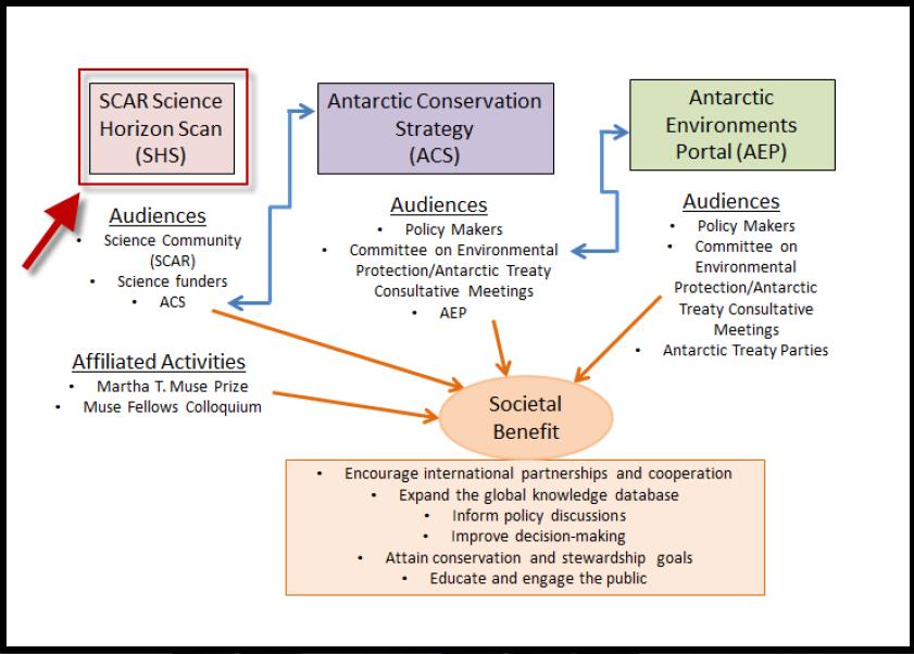
35 35

36 To reach for the horizon: A coordinated, portfolio of interdisciplinary science, based on enhanced international cooperation is essential Future Antarctic science will continue to address multi-disciplinary issues, will be complex and will require international collaborative efforts... No one scientist, program or nation can realize these aspirations alone 36

37 SCAR adaptation Interaction with the Community, National Committees and Partner Organizations New Member Countries Strategic Plan SCAR flag flying over theridge A international observatory 37 (Photo C. Kulesa, Feb. 2013)
38 New SCAR Strategic Plan SCAR will use the key questions arising from the 1st Antarctic and Southern Ocean Science Horizon Scan to guide research priorities and research direction over the next five years and beyond. SCAR s vision is to be an engaged, active, forward-looking organization that promotes, facilities, and delivers scientific excellence and evidence-based policy advice on globally significant issues that are relevant to Antarctica. 38
39 ATCM XXXIX- CEP XIX, Santiago, Chile, 2016 SCAR Science Lecture Exploring the Future of Scientific Research in Antarctica Jerónimo López-Martínez Universidad Autónoma de Madrid, Spain President of SCAR Photo: US National Science Foundation 39


40 ATCM XXXIX- CEP XIX, Santiago, Chile, 2016 SCAR Science Lecture Exploring the Future of Scientific Research in Antarctica Prof. Jerónimo López-Martínez Wednesday 25 May Room 1 (CEP Room) Photo: US National Science Foundation
Research Programme Polar, Marine and Coastal Systems. Current and future Arctic research priorities of Germany Nicole Biebow, AWI
 Research Programme Polar, Marine and Coastal Systems Current and future Arctic research priorities of Germany Nicole Biebow, AWI Arctic Science and Technology (S&T) Collaboration and Engagement Workshop,
NASA. Strategic Plan Connecting and Building Antarctic Research
 NASA Strategic Plan 2017-2022 Connecting and Building Antarctic Research 1 Preface COEA-IVIC / Venezuelan Antarctic Program Scientific Committee on Antarctic Research. 2017. Strategic Plan 2017-2022: Connecting
KUNMING FORUM ON UNITED NATIONS GLOBAL GEOSPATIAL INFORMATION MANAGEMENT CITIES OF THE FUTURE: SMART, RESILIENT
 KUNMING FORUM ON UNITED NATIONS GLOBAL GEOSPATIAL INFORMATION MANAGEMENT CITIES OF THE FUTURE: SMART, RESILIENT and SUSTAINABLE Yunnan Zhenzhuang Guest House, Kunming, China 10 12 May 2017 BACKGROUND CONCEPT
Implementing the Sustainable Development Goals: The Role of Geospatial Technology and Innovation
 Fifth High Level Forum on UN Global Geospatial Information Management Implementing the Sustainable Development Goals: The Role of Geospatial Technology and Innovation 28-30 November 2017 Sheraton Maria
Science in Antarctica and the role of the Scientific Committee on Antarctic Research (SCAR)
") J. Black Sea/Mediterranean Environment Vol. 20, No. 2: 127-136 (2014) REVIEW ARTICLE Science in Antarctica and the role of the Scientific Committee on Antarctic Research (SCAR) Jerónimo López-Martínez
J. Black Sea/Mediterranean Environment Vol. 20, No. 2: 127-136 (2014) REVIEW ARTICLE Science in Antarctica and the role of the Scientific Committee on Antarctic Research (SCAR) Jerónimo López-Martínez
SCAR AAA and its objectives
 SCAR AAA and its objectives John Storey, Chief Officer, AAA Image: Craig Kulesa Work program Our two tasks for this weekend: Write the astronomy & astrophysics submission to the Practical Guide to Enabling
White Paper Antarctic subglacial lake exploration
 White Paper Antarctic subglacial lake exploration Martin Siegert 1, John Priscu 2, Irina Alekhina 3, Jemma Wadham 4 and Berry Lyons 5. Convenors of the 7 th International Meeting on Antarctic Subglacial
SPLAN-Natura Towards an integrated spatial planning approach for Natura th January, 2017 Brussels. Commissioned by DG Environment
 SPLAN-Natura 2000 Towards an integrated spatial planning approach for Natura 2000 Commissioned by DG Environment 17 th January, 2017 Brussels V. Simeonova (Ph.D.) Drivers towards integrating Biodiversity
NOAA/OAR Observing Systems
 NOAA/OAR Observing Systems Dr. Christopher L. Sabine Director NOAA s Pacific Marine Environmental Laboratory Workshop on Hydroclimate Monitoring Systems and Measurement Needs June, 2014 Global Ocean Observing
Egypt-NOAA Cooperation: Advancing our Environmental Science, Technology, and Education
 Egypt-NOAA Cooperation: Advancing our Environmental Science, Technology, and Education T. G. Onsager NOAA Space Weather Prediction Center and NWS International Activities Office (one-year detail) Terry.Onsager@noaa.gov
Key Indicators for Territorial Cohesion & Spatial Planning Stakeholder Workshop - Project Update. 13 th December 2012 San Sebastián, Basque Country
 Key Indicators for Territorial Cohesion & Spatial Planning Stakeholder Workshop - Project Update 13 th December 2012 San Sebastián, Basque Country Key Aims Explore the use of territorial data in developing
CONFERENCE STATEMENT
 Final draft CONFERENCE STATEMENT We, the elected representatives of Canada, Denmark/Greenland, the European Parliament, Finland, Iceland, Norway, Russia, Sweden and the United States of America; In collaboration
ARICE Arctic Research Icebreaker Consortium for Europe A strategy for meeting the needs for marine research in the Arctic
 ARICE Arctic Research Icebreaker Consortium for Europe ARICE Arctic Research Icebreaker Consortium for Europe A strategy for meeting the needs for marine research in the Arctic 20 partners from Europe,
Geospatial framework for monitoring SDGs/Sendai targets By Shimonti Paul Sr. Assistant Editor Geospatial Media & Communications
 Geospatial framework for monitoring SDGs/Sendai targets By Shimonti Paul Sr. Assistant Editor Geospatial Media & Communications Outline 1. Introduction to Geospatial Media and Communications 2. Geospatial
The Future of Tourism in Antarctica: Challenges for Sustainability
 The Future of Tourism in Antarctica: Challenges for Sustainability Machiel Lamers Thesis summary In the last decade, Antarctic tourism has grown rapidly both in terms of volume and diversity. This growth
Services Requirements Paper Executive Council Panel of Experts on Polar & High Mountain Observations, Research, and Services
 Services Requirements Paper Executive Council Panel of Experts on Polar & High Mountain Observations, Research, and Services Aimee M. Devaris Regional Director U.S. National Oceanic and Atmospheric Administration
IPY International Polar Year Observing System Legacy
 International Polar Year - Observing System Legacy Dr E. Sarukhanian, Special Adviser to WMO Secretary- General on IPY 1 Purpose of the presentation IPY provides a unique opportunity to convert valuable
EABRN, 20 years of History and its Future (East Asia Biosphere Reserve Network)
") EABRN, 20 years of History and its Future (East Asia Biosphere Reserve Network) Choi Jongwon Director, MoE, Republic of Korea Contents 1 Overview and History 2 Key Activities (1) Regional Network Meetings
EABRN, 20 years of History and its Future (East Asia Biosphere Reserve Network) Choi Jongwon Director, MoE, Republic of Korea Contents 1 Overview and History 2 Key Activities (1) Regional Network Meetings
FINDINGS OF THE ARCTIC METEOROLOGY SUMMIT
 FINDINGS OF THE ARCTIC METEOROLOGY SUMMIT 2018 WWW.FMI.FI CHAIR S SUMMARY: 1 2 3 We need to be curious to explore the known unknowns. Meteorology is an elemental part of international collaboration in
2018/1 The integration of statistical and geospatial information. The Regional Committee of UN-GGIM: Americas:
 The following are the conclusions and recommendations of the Regional Committee of the United Nations on Global Geospatial Information Management for the Americas, during its Fifth Session, Thursday 8
The EU Arctic Cluster
 The EU Arctic Cluster Implementing the European Arctic Policy and fostering international cooperation Photo: Steffen Olsen www.eu-arcticcluster.eu Integrated European Union Policy for the Arctic 3 priority
Briefing. H.E. Mr. Gyan Chandra Acharya
 Briefing by H.E. Mr. Gyan Chandra Acharya Under-Secretary-General and High Representative for the Least Developed Countries, Landlocked Developing Countries and Small Island Developing States Briefing
EXPLORING COMMON SOLUTIONS IN ARCTIC METEOROLOGY FINLAND S CHAIRMANSHIP OF THE ARCTIC COUNCIL
 EXPLORING COMMON SOLUTIONS IN ARCTIC METEOROLOGY FINLAND S CHAIRMANSHIP OF THE ARCTIC COUNCIL 2017 2019 GENERAL OBJECTIVES Finland chairs the Arctic Council in 2017-2019. One of the chairmanship priorities
GENERAL RECOMMENDATIONS. Session 7. Breakout discussion. discuss on regional and interregional. proposals 1. COLLABORATION BETWEEN PROGRAMMES
 Session 7 24 July 2016, 9.00-11.00 Breakout discussion on regional and interregional joint project proposals Mr Shahbaz Khan summarized the two days of presentations and exchanges and requested the participants
EUSAIR on sea topics from Slovenian perspective
 MINISTRY OF FOREIGN AFFAIRS REPUBLIC OF SLOVENIA EUSAIR on sea topics from Slovenian perspective Mag. Andreja Jerina National Coordinator 4 EU MRS: 270 millions of population 19 MS 12 non MS Sea basin
International Union of Geodesy and Geophysics. Resolutions
 International Union of Geodesy and Geophysics Resolutions ADOPTED BY THE COUNCIL AT THE XXVI GENERAL ASSEMBLY PRAGUE, CZECH REPUBLIC (22 JUNE 2 JULY 2015) 0 Page Resolution 1: Role of Ocean in Climate
Improving Sub-Seasonal to Seasonal Prediction at NOAA
 Improving Sub-Seasonal to Seasonal Prediction at NOAA Dr. Louis W. Uccellini Director, National Weather Service NOAA Assistant Administrator for Weather Services July 13, 2016 Congressional Briefing Value
Greenland: Balancing the need for development and environmental protection. Arctic Frontiers 2016 Industry and Environment
 Greenland: Balancing the need for development and environmental protection Arctic Frontiers 2016 Industry and Environment Speech by Minister for Finance, Mineral Resources and Foreign Affairs Mr. Vittus
Faatasi Malologa (PGSC Chair) Director Department of Lands & Survey, Tuvalu
 Director Department of Lands & Survey, Tuvalu") Seventh Session of the United Nations Committee of Experts on Global Geospatial Information Management (UN-GGIM) - 31 July -4 August 2017 Faatasi Malologa (PGSC Chair) Director Department of Lands & Survey,
Seventh Session of the United Nations Committee of Experts on Global Geospatial Information Management (UN-GGIM) - 31 July -4 August 2017 Faatasi Malologa (PGSC Chair) Director Department of Lands & Survey,
Coastal Erosion & Climate Change: PRIDE 2005 Towards an Alaska Wind/Wave Climatology
 Coastal Erosion & Climate Change: PRIDE 2005 Towards an Alaska Wind/Wave Climatology 2 nd PRIDE Workshop August 9-10, 2005 David Atkinson, Int l Arctic Research Center, Univ. Of Alaska-Fairbanks James
THE ROLE OF GEOSPATIAL AT THE WORLD BANK
 THE ROLE OF GEOSPATIAL AT THE WORLD BANK INSPIRE Conference Barcelona, Spain September 26, 2016 Kathrine Kelm Senior Land Administration Specialist Global Land and Geospatial Unit The World Bank Group
Pacific Geospatial and Surveying Council (PGSC) Geospatial and GNSS CORS Infrastructure Forum. Kuala Lumpur October
 Geospatial and GNSS CORS Infrastructure Forum. Kuala Lumpur October") Pacific Geospatial and Surveying Council (PGSC) Geospatial and GNSS CORS Infrastructure Forum. Kuala Lumpur 16-17 October Beginning and Progress Members PGSC Charter PGSC Strategy 2017-2027 Meetings Geodetic
Pacific Geospatial and Surveying Council (PGSC) Geospatial and GNSS CORS Infrastructure Forum. Kuala Lumpur 16-17 October Beginning and Progress Members PGSC Charter PGSC Strategy 2017-2027 Meetings Geodetic
EC-PORS III Research. Sodankylä, February Developing a Polar Prediction System
 EC-PORS III Research Sodankylä, February 2012 Developing a Polar Prediction System Polar Prediction System - Status 1. EC-PORS I (Oct. 2009) -> initial discussions 2. WWRP/THORPEX Polar Prediction Workshop,
Ministry of Health and Long-Term Care Geographic Information System (GIS) Strategy An Overview of the Strategy Implementation Plan November 2009
 Strategy An Overview of the Strategy Implementation Plan November 2009") Ministry of Health and Long-Term Care Geographic Information System (GIS) Strategy An Overview of the Strategy Implementation Plan November 2009 John Hill, Health Analytics Branch Health System Information
Ministry of Health and Long-Term Care Geographic Information System (GIS) Strategy An Overview of the Strategy Implementation Plan November 2009 John Hill, Health Analytics Branch Health System Information
Introduction of the Asia-Oceania Global Earth Observation System of Systems (AOGEOSS) GEO Initiative(GI-22 )
 GEO Initiative(GI-22 )") Introduction of the Asia-Oceania Global Earth Observation System of Systems (AOGEOSS) GEO Initiative(GI-22 ) Prof. Xiang ZHOU Institute of Remote Sensing and Digital Earth, CAS 11 May 2017 Kunming, China
Introduction of the Asia-Oceania Global Earth Observation System of Systems (AOGEOSS) GEO Initiative(GI-22 ) Prof. Xiang ZHOU Institute of Remote Sensing and Digital Earth, CAS 11 May 2017 Kunming, China
Global Map: A Tool for Disaster Mitigation for the Asia and Pacific Region
 Global Map: A Tool for Disaster Mitigation for the Asia and Pacific Region D. R. Fraser Taylor Chair, International Steering Committee for Global Mapping (ISCGM) fraser_taylor@carleton.ca www. 18 th United
Observation (EO) & Geomatics in Canada
 & Geomatics in Canada") Innovating to Increase the Impact of Earth Observation (EO) & Geomatics in Canada Natural Resources Canada February 25, 2014 Prashant Shukle, Director General Canada Centre for Mapping and Earth Observation
Innovating to Increase the Impact of Earth Observation (EO) & Geomatics in Canada Natural Resources Canada February 25, 2014 Prashant Shukle, Director General Canada Centre for Mapping and Earth Observation
Meteorological instruments and observations methods: a key component of the Global Earth Observing System of Systems (GEOSS)
") GLOBAL OBSERVING SYSTEMS Instruments and Methods of Observation Programme Meteorological instruments and observations methods: a key component of the Global Earth Observing System of Systems (GEOSS) Dr.
GLOBAL OBSERVING SYSTEMS Instruments and Methods of Observation Programme Meteorological instruments and observations methods: a key component of the Global Earth Observing System of Systems (GEOSS) Dr.
Antarctic Marine Biodiversity Data Now Online
 Contact: Bruno Danis +32(2)6274139 bruno.danis@scarmarbin.be EMBARGOED UNTIL 9 a.m ECT, March 31 2009 Antarctic Marine Biodiversity Data Now Online An efficient network of specialists, data and tools to
The GMES/MyOcean Marine Service and its applications
 The GMES/MyOcean Marine Service and its applications P.Y. Le Traon (Ifremer) P. Bahurel (Mercator Ocean) First BreTel Workshop May 31st, 2012 - St Malo Outline The GMES Marine Service and MyOcean What
Spatial Data Availability Energizes Florida s Citizens
 NASCIO 2016 Recognition Awards Nomination Spatial Data Availability Energizes Florida s Citizens State of Florida Agency for State Technology & Department of Environmental Protection Category: ICT Innovations
Arctic Spatial Data Infrastructure Enabling Access to Arctic Location-Based Information
 Arctic Spatial Data Infrastructure Enabling Access to Arctic Location-Based Information Arctic SDI Side Event Co-Chairs: Arvo Kokkonen Arctic SDI Board Chair & Director General, National Land Survey of
Group on Earth Observations (GEO) Cold Regions Work Plan Item WA-01-C3
 Cold Regions Work Plan Item WA-01-C3") EC Panel of Experts on Polar Observations, Research and Services Group on Earth Observations (GEO) Cold Regions Work Plan Item WA-01-C3 Barbara J. Ryan Secretariat Director Lanzhou, China 13 March 2013
EC Panel of Experts on Polar Observations, Research and Services Group on Earth Observations (GEO) Cold Regions Work Plan Item WA-01-C3 Barbara J. Ryan Secretariat Director Lanzhou, China 13 March 2013
SUSTAINABLE OCEANS GOVERNANCE:: NEW APPROACHES. Oceans Governance: Shaping our Future Workshop USP, 1-2 December 2016
 SUSTAINABLE OCEANS GOVERNANCE:: NEW APPROACHES Oceans Governance: Shaping our Future Workshop USP, 1-2 December 2016 WHAT IS SUSTAINABLE OCEAN GOVERNANCE? O C E A N G O V E R N A N C E I S T H E C O N
Climate and Cryosphere Contributions for the Year of Polar Prediction (YOPP)
") Climate and Cryosphere Contributions for the Year of Polar Prediction (YOPP) 11 June 2015 Authors: Alice Bradley, University of Colorado, Boulder, USA (alice.bradley@colorado.edu) François Massonnet, Université
Climate and Cryosphere Contributions for the Year of Polar Prediction (YOPP) 11 June 2015 Authors: Alice Bradley, University of Colorado, Boulder, USA (alice.bradley@colorado.edu) François Massonnet, Université
Enabling Access to Arctic Location Based Information - the Arctic SDI
 Enabling Access to Arctic Location Based Information - the Arctic SDI Jani Kylmäaho Head of Arctic SDI Geoportal WG National Land Survey of Finland SAO Chair, WG Chairs and Executive Secretaries meeting
Background and History
 p1 Background and History What is the Indian Ocean Climate Initiative? The Indian Ocean Climate Initiative (IOCI) is a strategic program of research and information transfer to support government decision-making.
Evidence of Current Climate Change in the Polar Regions
 Evidence of Current Climate Change in the Polar Regions Dr. Mary Albert Cold Regions Research and Engineering Laboratory Thayer School of Engineering, Dartmouth College Hanover, NH Overview How do we detect
Newsletter Newsletter Published on Division for Planetary Sciences ( Issue 16-40, October 16, 2016
 Newsletter 16-40 Issue 16-40, October 16, 2016 +------------------------------------CONTENTS----------------------------------------+ 1. REMOTE PARTICIPATION FOR JWST WORKSHOP AND PROPOSAL TUTORIAL 2.
Enabling Access to Arctic Location Based Information
 Enabling Access to Arctic Location Based Information Kevin Gallagher Arctic SDI Board Chair, United States Geological Survey Alaska Surveying and Mapping Conference, GeoJam 15 February 2017 What is Arctic
Floats in the Seasonal ice zone
 Floats in the Seasonal ice zone Co-ordinator: Institut Français de Recherche pour l'exploitation de la Mer - France Potential for a task team has discussed at AST-15 Colleagues have been approached and
Global Mapping: A Tool for Disaster Mitigation
 Global Mapping: A Tool for Disaster Mitigation D. R. Fraser Taylor Chair, International Steering Committee for Global Mapping (ISCGM) fraser_taylor@carleton.ca www. United Nations Regional Cartographic
GEO Coastal Zone Community of Practice (CZCP)
") ! "#$%&" $'( )$*+,-.'// Global, regional and local trends in natural processes and human demands on coastal ecosystems jeopardize the ability of these ecosystems to support commerce, living resources,
! "#$%&" $'( )$*+,-.'// Global, regional and local trends in natural processes and human demands on coastal ecosystems jeopardize the ability of these ecosystems to support commerce, living resources,
Training on national land cover classification systems. Toward the integration of forest and other land use mapping activities.
 Training on national land cover classification systems Toward the integration of forest and other land use mapping activities. Guiana Shield 9 to 13 March 2015, Paramaribo, Suriname Background Sustainable
Economic and Social Council 2 July 2015
 ADVANCE UNEDITED VERSION UNITED NATIONS E/C.20/2015/11/Add.1 Economic and Social Council 2 July 2015 Committee of Experts on Global Geospatial Information Management Fifth session New York, 5-7 August
UN-GGIM: Strengthening Geospatial Capability
 Fifth Plenary Meeting of UN-GGIM: Europe Brussels, 6-7 June 2018 UN-GGIM: Strengthening Geospatial Capability Walking the talk to leave no one behind Greg Scott, UN-GGIM Secretariat Environmental Statistics
KENYA NATIONAL BUREAU OF STATISTICS Workshop on
 KENYA NATIONAL BUREAU OF STATISTICS Workshop on Capacity Building in Environment Statistics: the Framework for the Development of Environment Statistics (FDES 2013) Coordination with Sector Ministries
Applied Geoscience and Technology Division SOPAC. Joy Papao, Risk Information Systems Officer
 Joy Papao, Risk Information Systems Officer Secretariat of the Pacific Community SPC 22 Pacific Island States Head office in Noumea, New Caledonia 2 Regional offices (Pohnpei and Honiara) 600 staff 9 Technical
Statement (India) at the 1 st High Level Forum Meeting of United Nations Global Geospatial Information Management held at Seoul on 24 th October 2011
 at the 1 st High Level Forum Meeting of United Nations Global Geospatial Information Management held at Seoul on 24 th October 2011") Statement (India) at the 1 st High Level Forum Meeting of United Nations Global Geospatial Information Management held at Seoul on 24 th October 2011 T Ramasami, Secretary to The Government of India, Ministry
Statement (India) at the 1 st High Level Forum Meeting of United Nations Global Geospatial Information Management held at Seoul on 24 th October 2011 T Ramasami, Secretary to The Government of India, Ministry
Statement. H.E. Mr. Gyan Chandra Acharya
 As delivered Statement by H.E. Mr. Gyan Chandra Acharya Under-Secretary-General and High Representative for the Least Developed Countries, Landlocked Developing Countries and Small Island Developing States
8 th Arctic Regional Hydrographic Commission Meeting September 2018, Longyearbyen, Svalbard Norway
 8 th Arctic Regional Hydrographic Commission Meeting 11-13 September 2018, Longyearbyen, Svalbard Norway Status Report of the Arctic Regional Marine Spatial Data Infrastructures Working Group (ARMSDIWG)
The Global Integrated Polar Prediction System (GIPPS) and the Year of Polar Prediction (YOPP)
 and the Year of Polar Prediction (YOPP)") The Global Integrated Polar Prediction System (GIPPS) and the Year of Polar Prediction (YOPP) Thomas Jung Alfred Wegener Institute, Bremerhaven, Germany PRCC Scoping Workshop, 17 November 2015, Geneva
The Global Integrated Polar Prediction System (GIPPS) and the Year of Polar Prediction (YOPP) Thomas Jung Alfred Wegener Institute, Bremerhaven, Germany PRCC Scoping Workshop, 17 November 2015, Geneva
TOWARDS STRATEGIC SPATIAL PLANNING IN JAMAICA: THE NATIONAL SPATIAL PLAN
 TOWARDS STRATEGIC SPATIAL PLANNING IN JAMAICA: THE NATIONAL SPATIAL PLAN JIEP 5th Biennial Conference on the Environment: Balancing National Development and Environmental Protection June 6, 2011 Jamaica
The National Integrated Drought Information System (NIDIS) Moving the Nation from Reactive to Proactive Drought Risk Management
 Moving the Nation from Reactive to Proactive Drought Risk Management") The National Integrated Drought Information System (NIDIS) Moving the Nation from Reactive to Proactive Drought Risk Management CSG-West Annual Meeting Agriculture & Water Committee Snowbird, UT September
The National Integrated Drought Information System (NIDIS) Moving the Nation from Reactive to Proactive Drought Risk Management CSG-West Annual Meeting Agriculture & Water Committee Snowbird, UT September
THE CANADIAN CENTRE FOR CLIMATE MODELLING AND ANALYSIS
 THE CANADIAN CENTRE FOR CLIMATE MODELLING AND ANALYSIS As Canada s climate changes, and weather patterns shift, Canadian climate models provide guidance in an uncertain future. CANADA S CLIMATE IS CHANGING
PACIFIC ISLANDS REGIONAL OCEAN POLICY. A healthy Ocean that sustains the livelihoods and aspirations of Pacific Island communities.
 PACIFIC ISLANDS REGIONAL OCEAN POLICY VISION A healthy Ocean that sustains the livelihoods and aspirations of Pacific Island communities. THIS IS OUR OCEAN 1. The care of the ocean is the responsibility
Storm Surge/Coastal Inundation State of the Union. Jamie Rhome Storm Surge Team Lead NOAA/National Hurricane Center
 Storm Surge/Coastal Inundation State of the Union Jamie Rhome Storm Surge Team Lead NOAA/National Hurricane Center 2 Tampa: Cat 5 Scenario 3 4 The Stakes are High Combination of SLR and increasing coastal
ECONOMIC AND SOCIAL COUNCIL
 UNITED NATIONS E/CONF.102/3 ECONOMIC AND SOCIAL COUNCIL Nineteenth United Nations Regional Cartographic Conference for Asia and the Pacific Bangkok, 29 October 1 November 2012 Item 4 of the provisional
Economic and Social Council
 United Nation E/C.20/2012/4/Add.1 Economic and Social Council Distr.: General 2 July 2012 Original: English Committee of Experts on Global Geospatial Information Management Second session New York, 13-15
NOAA Arctic Priorities and Potential Contributions to PPP/YOPP. Randall Dole NOAA Earth System Research Laboratory Physical Sciences Division
 NOAA Arctic Priorities and Potential Contributions to PPP/YOPP Randall Dole NOAA Earth System Research Laboratory Physical Sciences Division 1 NOAA s Arctic Goals Forecast Sea Ice Strengthen Foundational
NCAR Unified Community Atmosphere Modeling Roadmap
 (Project) NCAR Unified Community Atmosphere Modeling Roadmap Andrew Gettelman, Bill Skamarock, Mary Barth, Jean-François Lamarque On behalf of the Singletrack Steering Group (Also a mountain biking Magazine:
Spatially Enabled Society
 International Seminar on Land Administration Trends and Issues in Asia and the Pacific Region Spatially Enabled Society Abbas Rajabifard Vice Chair PCGIAP-WG3 Vice-President (President Elect), GSDI Association
HY-2A Satellite User s Guide
 National Satellite Ocean Application Service 2013-5-16 Document Change Record Revision Date Changed Pages/Paragraphs Edit Description i Contents 1 Introduction to HY-2 Satellite... 1 2 HY-2 satellite data
What are the social, technical, environmental and economic benefits and opportunities of accessing and sharing geodetic data?
 What are the social, technical, environmental and economic benefits and opportunities of accessing and sharing geodetic data? Graeme Blick Group Manager Positioning and Resilience Land Information New
PROGRESS REPORT ON APPROACH PAPER THE IMPLEMENTATION OF THE GEF KNOWLEDGE MANAGEMENT. GEF/C.49/Inf.04 September 23, 2015
 49 th GEF Council Meeting October 20 22, 2015 Washington, D.C. GEF/C.49/Inf.04 September 23, 2015 PROGRESS REPORT ON THE IMPLEMENTATION OF THE GEF KNOWLEDGE MANAGEMENT APPROACH PAPER TABLE OF CONTENTS
Economic and Social Council
 United Nations Economic and Social Council Distr.: General 2 July 2012 E/C.20/2012/10/Add.1 Original: English Committee of Experts on Global Geospatial Information Management Second session New York, 13-15
GOVERNMENT MAPPING WORKSHOP RECOVER Edmonton s Urban Wellness Plan Mapping Workshop December 4, 2017
 GOVERNMENT MAPPING WORKSHOP 12.4.17 RECOVER Edmonton s Urban Wellness Plan Mapping Workshop December 4, 2017 In July of 2017, City Council directed administration to develop RECOVER, Edmonton s Urban Wellness
the IRIS Consortium Collaborative, Multi-user Facilities for Research and Education Briefing NSF Business Systems Review September 9, 2008
 the IRIS Consortium Collaborative, Multi-user Facilities for Research and Education Briefing NSF Business Systems Review September 9, 2008 A facilities program for collection and distribution of seismological
THE IMPACT OF EL NIÑO AND LA NIÑA ON SOUTHEAST ASIA
 THE IMPACT OF EL NIÑO AND LA NIÑA ON SOUTHEAST ASIA 21st-23rd February 2000 WORKSHOP SUMMARY Organized by the Indochina Global Change Network Funded by the Asia-Pacific Network for Global Change Research
Marine Spatial Planning: A Tool for Implementing Ecosystem-Based Management
 Marine Spatial Planning: A Tool for Implementing Ecosystem-Based Management Steven Murawski, Ph.D., Ecosystem Goal Team Lead National Oceanic and Atmospheric Administration NOAA November 16, 2009 1 To
Maritime Spatial Planning: Transboundary Cooperation in the Celtic Seas Looking Ahead
 Maritime Spatial Planning: Transboundary Cooperation in the Celtic Seas Looking Ahead Looking ahead MSP in the context of the European Maritime and Fisheries Fund (EMFF) and beyond SIMCelt Final Conference
Japan s Arctic Policy
 Japan s Arctic Policy October 16th, 2015 The Headquarters for Ocean Policy Contents 1 Introduction Rapidly Changing Arctic Environment and Increasing Interest over the Arctic 1 2 Background and Purpose
RCOF Review [Regional Climate Outlook Forum for the Gulf of Guinea region of Africa - PRESAGG] Status Report
![RCOF Review [Regional Climate Outlook Forum for the Gulf of Guinea region of Africa - PRESAGG] Status Report](/thumbs/78/77466191.jpg "RCOF Review [Regional Climate Outlook Forum for the Gulf of Guinea region of Africa - PRESAGG] Status Report") RCOF Review 2017 [Regional Climate Outlook Forum for the Gulf of Guinea region of Africa - PRESAGG] Status Report Specific Climate features of concerned region This region typically covers the area below
RCOF Review 2017 [Regional Climate Outlook Forum for the Gulf of Guinea region of Africa - PRESAGG] Status Report Specific Climate features of concerned region This region typically covers the area below
US National Spatial Data Infrastructure A Spatial Framework for Governance and Policy Development to Enable a Location-Based Digital Ecosystem
 GeoPlatform Workshop 7 Dec 2016, Department of the Interior Washington, D.C. US National Spatial Infrastructure A Spatial Framework for Governance and Policy Development to Enable a Location-Based Digital
Press Release: First WMO Workshop on Operational Climate Prediction
 Press Release: First WMO Workshop on Operational Climate Prediction a) b) c) d) Photographs during the first WMO Workshop on Operational Climate Prediction: a) Group Photograph, b) Dr M. Rajeevan, Director,
D2E GIS Coordination Initiative Functional Transformation Kick-Off Meeting
 D2E GIS Coordination Initiative Functional Transformation Kick-Off Meeting GIS Functional Transformation Kick-Off Meeting May 13, 2008 D2E GIS Coordination Initiative Functional Transformation Kick-Off
Academy of Finland Arctic Research Programme. Helsinki
 Academy of Finland Arctic Research Programme HENVI Seminar Helsinki 26.2.2014 Tuula Aarnio Public research funding in Finland Government research expenditure 2013 Total 2 billion Source: Statistics Finland
The Spatial Information Corridor Contributes to UNISPACE+50. JIANG HUI Director of Internation Cooperation Department
 The Spatial Information Corridor Contributes to UNISPACE+50 JIANG HUI Director of Internation Cooperation Department 01 02 03 What is Belt & Road Spatial Information Corridor? China put forward the "Belt
What is COSPAR and why does it matter to CAPS? Gregg Vane 16 September 2015
 What is COSPAR and why does it matter to CAPS? Gregg Vane 16 September 2015 Topics Overview of COSPAR Relevance to CAPS How to engage in an effective way 2 Overview of COSPAR Origin: Established by the
The Arctic Landscape Conservation Cooperative Conservation Goals
 The Arctic Landscape Conservation Cooperative Conservation Goals Adopted by the Arctic LCC Steering Committee, 24 August 2010 Background : Landscape Conservation Cooperatives and Climate Science Centers
USGS National Geospatial Program Understanding User Needs. Dick Vraga National Map Liaison for Federal Agencies July 2015
 + USGS National Geospatial Program Understanding User Needs Dick Vraga National Map Liaison for Federal Agencies July 2015 + Topics 2 Background Communities of Use User Surveys National Map Liaisons Partnerships
Climate Change Impacts in Alaska: the Weather Perspective
 Climate Change Impacts in Alaska: the Weather Perspective September 18, 2007 NOAA s National Weather Service, Alaska Region James Partain, Chief Environmental and Scientific Services Division NOAA NWS
Gaps in Space Weather Forecasting
 Gaps in Space Weather Forecasting Awareness Gap: Where is there uncertainty about how the scientific community can contribute to space weather operations? Areas With Good Awareness - All agencies recognize
Global Science in the Antarctic Context
 Global Science in the Antarctic Context British Antarctic Survey Strategy to 2012 Above and cover: Field party on the Brunt Ice Shelf, Antarctica. Our vision British Antarctic Survey aspires to become,
A unique international environmental research and monitoring platform
 A unique international environmental research and monitoring platform Prof. Dr. Karin Lochte Alfred Wegener Institute for Polar an Marine Research in the Helmholtz Association Climate change in the Arctic
SCAR e il Programma Nazionale di Ricerche Antartide
 SCAR e il Programma Nazionale di Ricerche Antartide Jerónimo López-Martínez Presidente dell SCAR Universidad Autónoma de Madrid, Spagna XII Conferenza Nazionale sulla Ricerche in Antartide 20-21 ottobre
Earth Observation and GEOSS in Horizon Copernicus for Raw Material Workshop 5 th September 2016
 Earth Observation and GEOSS in Horizon 2020 Copernicus for Raw Material Workshop 5 th September 2016 Gilles OLLIER Head of Sector -Earth observation Directorate Environment Unit I.4 Climate Actions and
May 14, MRC Capacity Gap Analysis Preliminary Results
 May 14, 2018 MRC Capacity Gap Analysis Preliminary Results Overview Determine current perceptions of the MRC program in Massachusetts Examine desired outcomes (by region) of the MRC program Supplement
How to shape future met-services: a seamless perspective
 How to shape future met-services: a seamless perspective Paolo Ruti, Chief World Weather Research Division Sarah Jones, Chair Scientific Steering Committee Improving the skill big resources ECMWF s forecast
Framework on reducing diffuse pollution from agriculture perspectives from catchment managers
 Framework on reducing diffuse pollution from agriculture perspectives from catchment managers Photo: River Eden catchment, Sim Reaney, Durham University Introduction This framework has arisen from a series