The Afar Rift Consortium
|
|
|
- Isaac Wood
- 6 years ago
- Views:
Transcription


1 The Afar Rift Consortium University of Bristol University of Oxford University of Cambridge British Geological Survey University of Rochester University of Auckland, NZ
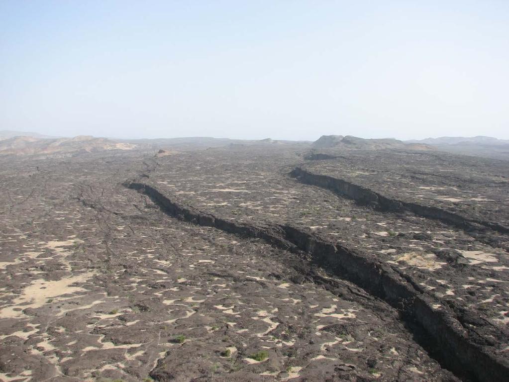
2 Opportunistic programme following start of dyking in the Dabbahu magmatic segment First such episode in the satellite era NERC Urgency grant got equipment in the field within 2 weeks Afar Rift Consortium conceived soon after
3 Programme structure Themed around 5 inter-disciplinary working groups A: where melt forms and ponds in the crust and mantle and how this correlates with zones of lithospheric stretching B: what the composition of magma is and how it evolves C: when previous eruptions have occurred and the time scale of magma evolution D: how magma moves through the crust and mantle (kinematics) E: why magma moves through the crust and mantle (dynamics)
4 Where Seismic tomography & receiver functions Magnetotellurics Links to petrology, remote sensing, seismicity, gravity, shear-wave splitting,
5 What is down there? Nature and relationships of magma, magma genesis and magmatism Modern petrology and geochemistry Inferences on volcanic processes and eruption mechanisms Relationships with all other groups e.g. physical properties of magma, modelling thermal evolution
6 When Eruptive history of Dabbahu magmatic segment and the timescales over which magmas evolved Isotopic chronometers Combine with other information to get time-stratigraphic framework to constrain rates of magma emplacement and eruption
7 How does melt move through the crust and lithosphere? does the brittle crust respond? insar GPS LiDAR topography Seismicity Shear-wave splitting
8 Why? Physical mechanisms responsible for lithospheric extension, magma movement, crustal segmentation and growth Integration of geophysical, geochemical and geological techniques Numerical and analogue modelling
9 also Advanced remote sensing to map lithology at multiple scales LiDAR and hyperspectral imaging Mapping of faults, features of flows Palaeomagnetic sampling Satellite data on eruptions (gases, temperatures, extrusive mapping) Updated geological map with GIS
10 6 year programme, coming to an end 3 main field seasons, many other visits to service and move equipment Shared resources, data with other groups (US, French) Interested in future collaboration 7 PhD students, ~4 Post-Docs Several AAU Project Partners had research periods in UK Universities
11 Where our equipment is GPS Main GPS stations within Afar
12 Seismic stations Where our equipment is Main seismic stations within Afar

13 Magnetotelluric sites Where our equipment is Sites where MT equipment has been installed
14 Volcanology sampling Where our equipment is Sites from where volcanic rocks have been collected
15 MT site distribution
16 Profile across active segment Best-fitting 2D model of resistivity parameterised in blocks
17 Joint interpretation Shallow conductor saline fluids in sediments and faulted and fractured basalt Evidence from geochemistry (and economic salt production from Danakil depression) Deeper conductors partial melt/ magma How much? Use petrology to constrain composition (Si, Na, H 2 O, T)

18 Joint interpretation High conductivities imply wellconnected melt Infer melt fraction from bulk and melt conductivity using HS + or parallel pathways models Parallel pathways consistent with OMP seismic anisotropy Minimum melt amount for given bulk conductivity 12% ~200 km 3 melt beneath profile
19 Joint interpretation Seismic evidence for melt in crust and upper mantle Receiver functions Surface waves Anisotropy Pn study Tomography from seismicity data
20
21
22

23 W Data and model fits Two quantities deduced from the data, in two orthogonal directions (plotted red and blue) Points are data, solid curves model predictions Data plotted horizontally as a function of period depth proxy E

24 SW Oblique profile towards Dabbahu volcano NE Large volumes of melt in crust and mantle

25 Comparison with inactive segment Higher resistivities much less magma No evidence for sub-crustal magma chamber
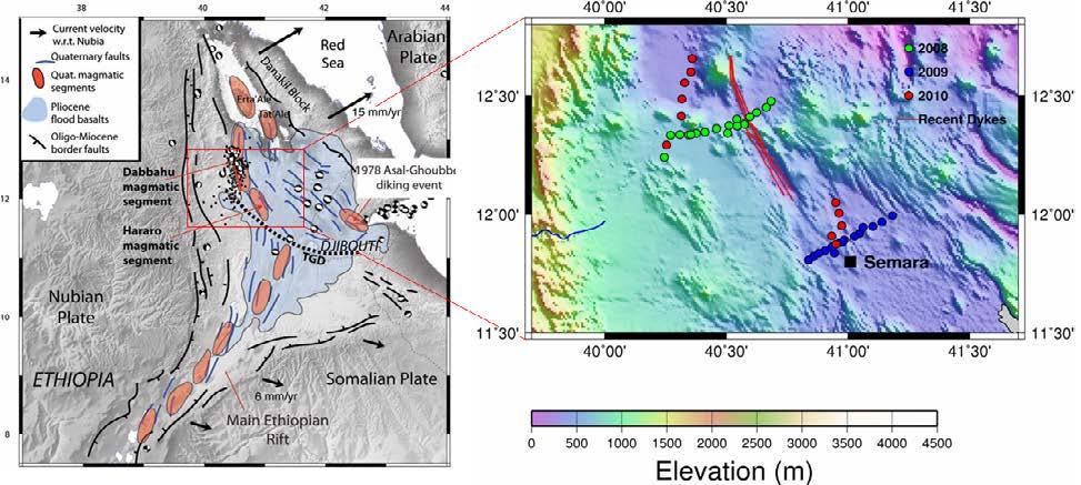
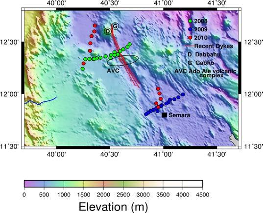
Magnetotelluric profile across the Dabbahu magmatic segment, Afar, Ethiopia
 Magnetotelluric profile across the Dabbahu magmatic segment, Afar, Ethiopia Abstract We have acquired high quality magnetotelluric (MT) and TEM (for static shift correction) data along a 50 km profile
TS Tectonics & Structural Geology Orals and PICOs Monday, 08 April
 TS Tectonics & Structural Geology Orals and PICOs Monday, 08 April MO1, 08:30 10:00 MO2, 10:30 12:00 MOL, 12:15 13:15 MO3, 13:30 15:00 MO4, 15:30 17:00 GD3.3/GM3.3/GMPV16/TS4.7, The evolution of plate
COMPOSITION and PHYSICAL PROPERTIES GENERAL SUBJECTS. GEODESY and GRAVITY
 COMPOSITION and PHYSICAL PROPERTIES Composition and structure of the continental crust Composition and structure of the core Composition and structure of the mantle Composition and structure of the oceanic
Remote Sensing of the Earth s Interior
 Remote Sensing of the Earth s Interior Earth s interior is largely inaccessible Origin and Layering of the Earth: Geochemical Perspectives Composition of Earth cannot be understood in isolation Sun and
Interplay between tectonics and magmatism during the last stages of continental breakup
 R. Pik, P. Burnard, A. Williams, C. Vye, L. France, D. Ayalew, G. Yirgu Interplay between tectonics and magmatism during the last stages of continental breakup The Manda Hararo rift segment, Afar, Ethiopia
Geophysical Surveys of The Geothermal System of The Lakes District Rift, Ethiopia
 Geophysical Surveys of The Geothermal System of The Lakes District Rift, Ethiopia By: Befekadu Oluma By: Geophysics Department Geological Survey of Ethiopia The formation of the rift was preceded by a
An Introduction of Aleutian Subduction Zone. Chuanmao Yang, Hong Yang, Meng Zhang, Wenzhong Wang 2016/04/29
 An Introduction of Aleutian Subduction Zone Chuanmao Yang, Hong Yang, Meng Zhang, Wenzhong Wang 2016/04/29 Outline General Introduction Formation history Structure from seismic study geochemical features
Earthquakes. Earthquakes are caused by a sudden release of energy
 Earthquakes Earthquakes are caused by a sudden release of energy The amount of energy released determines the magnitude of the earthquake Seismic waves carry the energy away from its origin Fig. 18.1 Origin
A) B) C) D) 4. Which diagram below best represents the pattern of magnetic orientation in the seafloor on the west (left) side of the ocean ridge?
 B) C) D) 4. Which diagram below best represents the pattern of magnetic orientation in the seafloor on the west (left) side of the ocean ridge?") 1. Crustal formation, which may cause the widening of an ocean, is most likely occurring at the boundary between the A) African Plate and the Eurasian Plate B) Pacific Plate and the Philippine Plate C)
1. Crustal formation, which may cause the widening of an ocean, is most likely occurring at the boundary between the A) African Plate and the Eurasian Plate B) Pacific Plate and the Philippine Plate C)
Subject Classification
 Istituto Nazionale di Geofisica e Vulcanologia earth-prints home page roma library bologna library catania library milano library napoli library palerm Subject Classification Earth-prints organize its
Chapter 18 - Volcanic Activity. Aka Volcano Under the City
 Chapter 18 - Volcanic Activity Aka Volcano Under the City 18.1 Magma Describe factors that affect the formation of magma. Compare and contrast the different types of magma. Temperature and pressure increase
. Slide 1. Geological Survey of Ethiopia, P.O.Box 2302, Addis Ababa, Ethiopia
 The electrical resistivity structure of the Southern Main Ethiopian Rift (around the Lake Abaya geothermal prospect) revealed by magneto-telluric telluric imaging Mohammednur Desissa and Yohanes Lema Geological
Does the SDCP need inputs from geology?
 The British Geological Survey s Experience and Expertise in Supporting Projects such as the Sirte Depression Connection Project David Ovadia Director of International Kingsley Dunham Centre Keyworth Nottingham
USING ANISOTROPY OF MAGNETIC SUSCEPTIBILITY TO DETERMINE FLOW DIRECTIONS OF THE DEVIL TRACK AND KIMBALL CREEK RHYOLITES
 USING ANISOTROPY OF MAGNETIC SUSCEPTIBILITY TO DETERMINE FLOW DIRECTIONS OF THE DEVIL TRACK AND KIMBALL CREEK RHYOLITES DHIREN R. PATEL Macalester College Sponsor: John Craddock INTRODUCTION Extrusive
EAS 116 Earthquakes and Volcanoes
 EAS 116 Earthquakes and Volcanoes J. Haase Forecasting Volcanic Eruptions Assessment of Volcanic Hazard Is that volcano active? Mount Lassen: 12000 BP and 1915 Santorini, IT: 180,000 BP, 70,000 BP, 21000
Magmatic Rifting and Active Volcanism Conference 2012, January 11-13, Addis Ababa.
 Magmatic Rifting and Active Volcanism Conference 2012, January 11-13, Addis Ababa. DallolVolcano and Danakil Depression, Ethiopia TadiwosChernet* Research and Development Centre, Ministry of Mines, P.O.Box
USU 1360 TECTONICS / PROCESSES
 USU 1360 TECTONICS / PROCESSES Observe the world map and each enlargement Pacific Northwest Tibet South America Japan 03.00.a1 South Atlantic Arabian Peninsula Observe features near the Pacific Northwest
The continental lithosphere
 Simplicity to complexity: The continental lithosphere Reading: Fowler p350-377 Sampling techniques Seismic refraction Bulk crustal properties, thickness velocity profiles Seismic reflection To image specific
Magnetotelluric and Seismic Investigation of Arc Melt Generation, Delivery, and Storage beneath Okmok Volcano
 Magnetotelluric and Seismic Investigation of Arc Melt Generation, Delivery, and Storage beneath Okmok Volcano PIs Ninfa Bennington (U. Wisconsin-Madison) and Kerry Key (Scripps Institution of Oceanography)
Plate Tectonics. entirely rock both and rock
 Plate Tectonics I. Tectonics A. Tectonic Forces are forces generated from within Earth causing rock to become. B. 1. The study of the origin and arrangement of Earth surface including mountain belts, continents,
Global Tectonics. Kearey, Philip. Table of Contents ISBN-13: Historical perspective. 2. The interior of the Earth.
 Global Tectonics Kearey, Philip ISBN-13: 9781405107778 Table of Contents Preface. Acknowledgments. 1. Historical perspective. 1.1 Continental drift. 1.2 Sea floor spreading and the birth of plate tectonics.
ANOTHER MEXICAN EARTHQUAKE! Magnitude 7.1, Tuesday Sept. 19, 2017
 ANOTHER MEXICAN EARTHQUAKE! Magnitude 7.1, Tuesday Sept. 19, 2017 Why is there no oceanic crust older than 200 million years? SUBDUCTION If new oceanic crust is being continuously created along the earth
The countdown to drilling in the Southern Thomson Orogen
 SMEDG NOVEMBER 2016 SYDNEY The countdown to drilling in the Southern Thomson Orogen John Greenfield Director Geoscience Acquisition & Synthesis Geological Survey of New South Wales Aim: Unlock a new mineral
TS Tectonics & Structural Geology Orals Monday, 28 April
 TS Tectonics & Structural Geology Orals Monday, 28 April MO1, 08:30 10:00 MO2, 10:30 12:00 MOL, 12:15 13:15 MO3, 13:30 15:00 MO4, 15:30 17:00 GD3.2/TS9.7, Recent advances in computational geodynamics (co-organized),
Magma Migration, Storage and Evolution in the Galápagos Region John Sinton University of Hawai i
 Magma Migration, Storage and Evolution in the Galápagos Region John Sinton University of Hawai i The Importance of Magma Supply and its relationship to mantle melting Magma Chamber Processes as deduced
Petrology. Petrology: the study of rocks, especially aspects such as physical, chemical, spatial and chronoligic. Associated fields include:
 Petrology Petrology: the study of rocks, especially aspects such as physical, chemical, spatial and chronoligic. Associated fields include: Petrography: study of description and classification of rocks
GEOTHERMAL ENERGY POTENTIAL FOR LONGONOT PROSPECT, KENYA. By Mariita N. O. Kenya Electricity Generating Company
 GEOTHERMAL ENERGY POTENTIAL FOR LONGONOT PROSPECT, KENYA By Mariita N. O. Kenya Electricity Generating Company PRESENTATION OUTLINE INTRODUCTION REGIONAL SETTING GEOLOGY GEOTHERMAL MANIFESTATIONS HYDROGEOLOGY
Igneous Rocks. Igneous Rocks. Genetic Classification of
 Igneous Rocks Fig. 5.1 Genetic Classification of Igneous Rocks Intrusive: crystallized from slowly cooling magma intruded within the Earth s crust; e.g. granite, gabbro 1 Fig. 5.2 Genetic Classification
Regional and local variations in geochemistry and tectonics along and across Central America
 Regional and local variations in geochemistry and tectonics along and across Central America Michael J. Carr, Department of Geological Sciences, Wright Lab Rutgers University, 610 Taylor Rd., Piscataway
Plate Tectonics. By Destiny, Jarrek, Kaidence, and Autumn
 Plate Tectonics By Destiny, Jarrek, Kaidence, and Autumn .The Denali Fault and San Andreas Fault - The San Andreas Fault is a continental transform fault that extends roughly 1300 km (810 miles) through
Before Plate Tectonics: Theory of Continental Drift
 Before Plate Tectonics: Theory of Continental Drift Predecessor to modern plate tectonics Shape and fit of the continents was the initial evidence Snider-Pelligrini (1858) Taylor (1908) Wegner (1915) Fig.
Plate Tectonics and the cycling of Earth materials
 Plate Tectonics and the cycling of Earth materials Plate tectonics drives the rock cycle: the movement of rocks (and the minerals that comprise them, and the chemical elements that comprise them) from
Wilson cycle. 1. Intracontinental rift 2. From rifting to drifting
 Wilson cycle 1. Intracontinental rift 2. From rifting to drifting Stages of the Wilson Cycle Intracontinental Rifts 1. Contemporary examples (EAR, RGR, Baikal, Rhine graben) 2. Mechanical aspects. Characteristics
University of Leeds 3GP Geophysics Field Trip Lake Balaton, Hungary
 University of Leeds 3GP Geophysics Field Trip Lake Balaton, Hungary September 1-15, 2007 geological background and logistics Staff: Greg Houseman, Graham Stuart The Alpine-Carpathian-Pannonian System Elevation
1 Introduction. 1.1 Aims. 1.2 Rock fractures
 1 Introduction 1.1 Aims Rock fractures occur in a variety of geological processes and range in size from plate boundaries at the scale of hundreds of kilometres to microcracks in crystals at the scale
Announcements. Manganese nodule distribution
 Announcements Lithospheric plates not as brittle as previously thought ESCI 322 Meet in Env. Studies Bldg Rm 60 at 1 PM on Tuesday One week (Thursday): Quiz on Booth 1994 and discussion. (Lots of odd terms
Summary. Study Area. Data Acquisition
 Evidence for hyper-extended continental crust in the East Orphan Basin from seismic reflection data and potential field forward modelling and inversion J. Kim Welford 1, Deric Cameron 2, James Carter 2
Taller de Geotermica en Mexico Geothermal Energy Current Technologies
 Taller de Geotermica en Mexico Geothermal Energy Current Technologies presented by Paul Brophy, President/CEO EGS Inc. Mexico City October 10 th 2011 Presentation Topics General Geothermal Discussion Exploration
Yellowstone Hotspot Component of the Plate Boundary Observatory
 Yellowstone Hotspot Component of the Plate Boundary Observatory (Investigators: Smith, Thatcher, Meertens, Humphreys, Dzurisin, Oldow Co-Investigators: Christiansen, Doss, Schwartz, Machette, Wong, Olig,
How does the mantle beneath the Ring of Fire change through time?: a trace element
 Page 1 How does the mantle beneath the Ring of Fire change through time?: a trace element study of primitive basalts erupted in a small area in the Southern Cascades Abstract I will test the hypothesis
Gravity Tectonics Volcanism Atmosphere Water Winds Chemistry. Planetary Surfaces
 Gravity Tectonics Volcanism Atmosphere Water Winds Chemistry Planetary Surfaces Gravity & Rotation Polar flattening caused by rotation is the largest deviation from a sphere for a planet sized object (as
Data Repository Comeau et al., (2015)
") Data Repository 2015087 Comeau et al., (2015) 1. Magnetotelluric data Owing to the remote location, and large distance from sources of electromagnetic noise, most stations were characterized by high quality
Data Repository 2015087 Comeau et al., (2015) 1. Magnetotelluric data Owing to the remote location, and large distance from sources of electromagnetic noise, most stations were characterized by high quality
Volcano Seismicity and Tremor. Geodetic + Seismic
 Volcano Seismicity and Tremor Seismic Imaging Geodetic + Seismic Model based joint inversion Geodetic Monitoring How is magma stored in the crust? geometry, volume and physical state of crustal melts.
Magmatic Processes at Subduction Zones
 Magmatic Processes at Subduction Zones Katherine A. Kelley Graduate School of Oceanography Univ. of Rhode Island Thanks to Terry Plank Erik Hauri GVP: Liz Cottrell Simon Carn Jennifer Jay Ed Venzke Subduction
The Santorini Inflation Episode, Monitored by InSAR and GPS
 The Santorini Inflation Episode, Monitored by InSAR and GPS Ioannis Papoutsis 1,2, Xanthos Papanikolaou 2, Michael Floyd 3, Kang Hyeun Ji 4, Charalampos Kontoes 1, Demitris Paradissis 2, Demitris Anastasiou
NOTICE CONCERNING COPYRIGHT RESTRICTIONS
 NOTICE CONCERNING COPYRIGHT RESTRICTIONS This document may contain copyrighted materials. These materials have been made available for use in research, teaching, and private study, but may not be used
The Role of Magnetotellurics in Geothermal Exploration
 The Role of Magnetotellurics in Geothermal Exploration Adele Manzella CNR - Via Moruzzi 1 56124 PISA, Italy manzella@igg.cnr.it Foreword MT is one of the most used geophysical methods for geothermal exploration.
GO ON. Directions: Use the diagram below to answer question 1.
 d i a g n o s t i c t e s t : e a r t h a n d s p a c e s c i e n c e question 1. 1. What is the correct order (starting from the surface) of Earth s layers? A crust, outer core, inner core, mantle B mantle,
Chang Wenbo.
 The spatial and temporal distributions of the late Mesozoic volcanic successions in the Changling fa ult depression of the Songliao Basin, NE China, and their controlling effects Chang Wenbo susanna0703@163.com
GEOLOGY CURRICULUM. Unit 1: Introduction to Geology
 Chariho Regional School District - Science Curriculum September, 2016 GEOLOGY CURRICULUM Unit 1: Introduction to Geology OVERVIEW Summary In this unit students will be introduced to the field of geology.
GD3.3/GM3.3/GMPV16/TS4.7
 GD Geodynamics Orals and PICOs MO1, 08:30 10:00 MO2, 10:30 12:00 MO3, 13:30 15:00 MO4, 15:30 17:00 TU1, 08:30 10:00 TU2, 10:30 12:00 TU3, 13:30 15:00 Monday, 08 April Medal Lecture) (co-organized), 08:30
The Structure of the Earth and Plate Tectonics
 The Structure of the Earth and Plate Tectonics Agree or Disagree? 1. The Earth if made up of 4 different layers. 2. The crust (where we live) can be made of either less dense continental crust or the more
TORFAJÖKULL, ICELAND A RHYOLITE VOLCANO AND ITS GEOTHERMAL RESOURCE
 Presented at Short Course VI on Exploration for Geothermal Resources, organized by UNU-GTP, GDC and KenGen, at Lake Bogoria and Lake Naivasha, Kenya, Oct. 27 Nov. 18, 2011. GEOTHERMAL TRAINING PROGRAMME
The influence of short wavelength variations in viscosity on subduction dynamics
 1 Introduction Deformation within the earth, driven by mantle convection due primarily to cooling and subduction of oceanic lithosphere, is expressed at every length scale in various geophysical observations.
MT Prospecting. Map Resistivity. Determine Formations. Determine Structure. Targeted Drilling
 MT Prospecting Map Resistivity Determine Formations Determine Structure Targeted Drilling Cross-sectional interpretation before and after an MT survey of a mineral exploration prospect containing volcanic
Receiver function studies of crustal structure, composition, and evolution beneath the Afar Depression, Ethiopia
 Receiver function studies of crustal structure, composition, and evolution beneath the Afar Depression, Ethiopia PhD Dissertation Sattam A. Almadani Missouri University of Science & Technology (MST) Rolla,
Global geophysics and wave propagation
 Global geophysics and wave propagation Reading: Fowler p76 83 Remote sensing Geophysical methods Seismology Gravity and bathymetry Magnetics Heat flow Seismology: Directly samples the physical properties
Petrology. Petrology: the study of rocks, especially aspects such as physical, chemical, spatial and chronoligic. Classification:
 Petrology Petrology: the study of rocks, especially aspects such as physical, chemical, spatial and chronoligic. Associated fields include: Petrography: study of description and classification of rocks
How to Build a Mountain and other Geologic Structures. But first, questions
 How to Build a Mountain and other Geologic Structures But first, questions Questions your students might ask How were Montana s mountains formed? How old are the mountains? What are the different ways
Volcano Deformation in the Main Ethiopian Rift
 Volcano Deformation in the Main Ethiopian Rift Juliet Biggs 1 ; Ian Bastow 1, Derek Keir 2, Elias Lewi 3, 1 University of Bristol; 2 University of Leeds; 3 University of Addis Ababa Seismic and Eruption
Topic 12: Dynamic Earth Pracatice
 Name: Topic 12: Dynamic Earth Pracatice 1. Earth s outer core is best inferred to be A) liquid, with an average density of approximately 4 g/cm 3 B) liquid, with an average density of approximately 11
Plate Tectonics: The New Paradigm
 Earth s major plates Plate Tectonics: The New Paradigm Associated with Earth's strong, rigid outer layer: Known as the lithosphere Consists of uppermost mantle and overlying crust Overlies a weaker region
INTERGRATED GEOPHYSICAL METHODS USED TO SITE HIGH PRODUCER GEOTHERMAL WELLS
 Presented at Short Course VII on Exploration for Geothermal Resources, organized by UNU-GTP, GDC and KenGen, at Lake Bogoria and Lake Naivasha, Kenya, Oct. 27 Nov. 18, 2012. GEOTHERMAL TRAINING PROGRAMME
SUPPLEMENTARY INFORMATION
 SUPPLEMENTARY INFORMATION Supplementary online material for Bai et al., (2). EHS3D MT data collection Broadband magnetotelluric (MT) data were recorded on profiles P, P2 and P4 in the frequency band -.5
MIGRATING SWARMS OF BRITTLE-FAILURE EARTHQUAKES IN THE LOWER CRUST BENEATH MAMMOTH MOUNTAIN, CALIFORNIA
 MIGRATING SWARMS OF BRITTLE-FAILURE EARTHQUAKES IN THE LOWER CRUST BENEATH MAMMOTH MOUNTAIN, CALIFORNIA David Shelly and David Hill GRL, October 2011 Contents Tectonic Setting Long Valley Caldera Mammoth
The Structure of the Earth and Plate Tectonics
 The Structure of the Earth and Plate Tectonics Structure of the Earth The Earth is made up of 4 main layers: Inner Core Outer Core Mantle Crust Crust Mantle Outer core Inner core The Crust This is where
Continental Margin Geology of Korea : Review and constraints on the opening of the East Sea (Japan Sea)
") Continental Margin Geology of Korea : Review and constraints on the opening of the East Sea (Japan Sea) Han-Joon Kim Marine Satellite & Observation Tech. Korea Ocean Research and Development Institute
Continental Margin Geology of Korea : Review and constraints on the opening of the East Sea (Japan Sea) Han-Joon Kim Marine Satellite & Observation Tech. Korea Ocean Research and Development Institute
Unit 4 Lesson 4 Volcanoes. Copyright Houghton Mifflin Harcourt Publishing Company
 Magma Magic What is a volcano? A volcano is any place where gas, ash, or melted rock come out of the ground. Many volcanoes are dormant, meaning an eruption has not occurred in a long period of time. What
TECTONIC AND STRUCTURAL CONTROLS ON INTRUSION- RELATED DEPOSITS IN THE NORTHERN PART OF SREDNA GORA ZONE, BULGARIA NIKOLAY PETROV & KAMELIA NEDKOVA
 TECTONIC AND STRUCTURAL CONTROLS ON INTRUSION- RELATED DEPOSITS IN THE NORTHERN PART OF SREDNA GORA ZONE, BULGARIA NIKOLAY PETROV & KAMELIA NEDKOVA INVESTIGATED AREA Praveshka Lakavica deposit Elatsite
Earthscope in the Northern Rockies Workshop
 Earthscope in the Northern Rockies Workshop Co-conveners: David Foster - University of Florida Paul Mueller - University of Florida David Mogk - Montana State University EarthScope in the Northern Rockies
Integrated Geophysical Model for Suswa Geothermal Prospect using Resistivity, Seismics and Gravity Survey Data in Kenya
 Proceedings World Geothermal Congress 2015 Melbourne, Australia, 19-25 April 2015 Integrated Geophysical Model for Suswa Geothermal Prospect using Resistivity, Seismics and Gravity Survey Data in Kenya
Joint Interpretation of Magnetotelluric and Seismic Models for Exploration of the Gross Schoenebeck Geothermal Site
 Joint Interpretation of Magnetotelluric and Seismic Models for Exploration of the Gross Schoenebeck Geothermal Site G. Muñoz, K. Bauer, I. Moeck, O. Ritter GFZ Deutsches GeoForschungsZentrum Introduction
Geo-scientific Data Integration to Evaluate Geothermal Potential Using GIS (A Case for Korosi-Chepchuk Geothermal Prospects, Kenya)
") Geo-scientific Data Integration to Evaluate Geothermal Potential Using GIS (A Case for Korosi-Chepchuk Geothermal Prospects, Kenya) Levi Shako and Joseph Mutua Geothermal Development Company, P. O. Box
Geo-scientific Data Integration to Evaluate Geothermal Potential Using GIS (A Case for Korosi-Chepchuk Geothermal Prospects, Kenya) Levi Shako and Joseph Mutua Geothermal Development Company, P. O. Box
Earth Science Lesson Plan Quarter 3, Week 7, Day 1
 Earth Science Lesson Plan Quarter 3, Week 7, Day 1 Outcomes for Today Standard Focus: PREPARE 1. Background knowledge necessary for today s reading. Continental ice sheets increase the weight of the Earth
Plate Tectonics Unit II: Plate Boundaries (3.5 pts)
") T. James Noyes, El Camino College Plate Tectonics Unit II: The Plate Boundaries (Topic 11A-2) page 1 Name: Section: Plate Tectonics Unit II: Plate Boundaries (3.5 pts) Plate Boundaries We will now discuss
T. James Noyes, El Camino College Plate Tectonics Unit II: The Plate Boundaries (Topic 11A-2) page 1 Name: Section: Plate Tectonics Unit II: Plate Boundaries (3.5 pts) Plate Boundaries We will now discuss
Junior Research Fellowship in Geology. Test Code: RG (Short answer + Objective type) 2010
 2010") Junior Research Fellowship in Geology Test Code: RG (Short answer + Objective type) 2010 The candidates for Junior Research Fellowship in Geology will have to take two tests- Test GM in the forenoon session
Junior Research Fellowship in Geology Test Code: RG (Short answer + Objective type) 2010 The candidates for Junior Research Fellowship in Geology will have to take two tests- Test GM in the forenoon session
ERTH2104 Winter Igneous Systems, Geochemistry and Processes. Instructor: Brian Cousens
 ERTH2104 Winter 2019 Igneous Systems, Geochemistry and Processes Instructor: Brian Cousens Igneous Petrology is the study of processes that produce melts (magmas) within the Earth, how these melts then
Seismo-volcanic crisis in Afar: the 2005 Boina rupture-eruption sequence
 NERC GEOPHYSICAL EQUIPMENT FACILITY (Seis-UK) PROJECT 0803 SCIENTIFIC REPORT Seismo-volcanic crisis in Afar: the 2005 Boina rupture-eruption sequence Cindy Ebinger*, Derek Keir#, James Hammond^, and Tim
A new era of geodetic big data - challenges and opportunities Tim Wright (COMET, University of
 A new era of geodetic big data - challenges and opportunities Tim Wright (COMET, University of Leeds) S @NERC_COMET N A New Era of Geodetic Big Data? GEM Strain Rate Model 17,491 GNSS sites included in
GEOTHERMAL DEVELOPMENT IN THE COMOROS AND RESULTS OF GEOTHERMAL SURFACE EXPLORATION
 Proceedings, 6 th African Rift Geothermal Conference Addis Ababa, Ethiopia, 2 nd 4 th November 2016 GEOTHERMAL DEVELOPMENT IN THE COMOROS AND RESULTS OF GEOTHERMAL SURFACE EXPLORATION Mohamed Chaheire,
Introduction To Plate Tectonics Evolution. (Continents, Ocean Basins, Mountains and Continental Margins)
") Introduction To Plate Tectonics Evolution (Continents, Ocean Basins, Mountains and Continental Margins) Geo 386 (Arabian Shield Course) Dr. Bassam A. A. Abuamarah Mohanna G E O 3 8 6 A R A B I A N G E
Introduction To Plate Tectonics Evolution (Continents, Ocean Basins, Mountains and Continental Margins) Geo 386 (Arabian Shield Course) Dr. Bassam A. A. Abuamarah Mohanna G E O 3 8 6 A R A B I A N G E
UNIT 3 GEOLOGY VOCABULARY FLASHCARDS THESE KEY VOCABULARY WORDS AND PHRASES APPEAR ON THE UNIT 3 CBA
 UNIT 3 GEOLOGY VOCABULARY FLASHCARDS THESE KEY VOCABULARY WORDS AND PHRASES APPEAR ON THE UNIT 3 CBA A map that shows Earth s Topographic Map surface topography, which is Earth s shape and features Contour
PLATE TECTONICS REVIEW GAME!!!!
 PLATE TECTONICS REVIEW GAME!!!! Name the four layers of the earth - crust - mantle - outer core - inner core Which part of Earth s structure contains tectonic plates? LITHOSPHERE Name one reason why the
Photo credit: S Dumont
 Satellite Monitoring of the 2014 Dyke Intrusion and Eruption within the Bárðarbunga Volcanic System, facilitated by the CEOS Icelandic SUPERSITE M Parks, S Dumont, V Drouin, F Sigmundsson, K Spaans, A
A N 62d. Oceanic Crust. 'hot 7-- Jeffrey A. Karson
 DEFENSE TECHNICAL INFORMATION CENTER 4583 FINAL REI)(.LiT ONR Grant N00014-90-J-1043 Variations in Tectonic Extension Along Slow-Spreading Ridge Axes: Implications for the Internal Structure and Bathymetry.of
Unit 4 Lesson 7 Mountain Building
 Indiana Standards 7.2.4 Explain how convection currents in the mantle cause lithospheric plates to move causing fast changes like earthquakes and volcanic eruptions, and slow changes like creation of mountains
Late 20 th Century Tests of the Continental Drift Hypothesis
 Late 20 th Century Tests of the Continental Drift Hypothesis 5 Characteristics of the Ocean Trenches Unless otherwise noted the artwork and photographs in this slide show are original and by Burt Carter.
Name Class Date. 1. What is the outermost layer of the Earth called?. a. core b. lithosphere c. asthenosphere d. mesosphere
 Name Class Date Assessment Geology Plate Tectonics MULTIPLE CHOICE Write the letter of the correct answer in the space provided. 1. What is the outermost layer of the Earth called?. a. core b. lithosphere
Questions and Topics
 Plate Tectonics and Continental Drift Questions and Topics 1. What are the theories of Plate Tectonics and Continental Drift? 2. What is the evidence that Continents move? 3. What are the forces that
The Earth. Part II: Solar System. The Earth. 1a. Interior. A. Interior of Earth. A. The Interior. B. The Surface. C. Atmosphere
 Part II: Solar System The Earth The Earth A. The Interior B. The Surface C. Atmosphere 2 Updated: July 14, 2007 A. Interior of Earth 1. Differentiated Structure 2. Seismography 3. Composition of layers
Crustal Velocity Structure from Surface Wave Dispersion Tomography in the Indian Himalaya
 Crustal Velocity Structure from Surface Wave Dispersion Tomography in the Indian Himalaya Warren Caldwell Stanford University Page 33 in Extended Abstracts volume Partial Melt in the Mid-Crust of the Northwest
Forces That Shape Earth. How do continents move? What forces can change rocks? How does plate motion affect the rock cycle?
 Forces That Shape Earth How do continents move? What forces can change rocks? How does plate motion affect the rock cycle? Plate Motion Mountain ranges are produced by plate tectonics. The theory of plate
Exploration of Geothermal High Enthalpy Resources using Magnetotellurics an Example from Chile
 Exploration of Geothermal High Enthalpy Resources using Magnetotellurics an Example from Chile Ulrich Kalberkamp, Federal Institute for Geosciences and Natural Resources (BGR), Stilleweg 2, 30655 Hannover,
James Francis Natukunda
 James Francis Natukunda Department of Geological Surveys and Mines Ministry of Energy and Mineral Development, Uganda Regional stakeholders workshop for EARS countries and partners Nairobo, Kenya 15-17
GEOLOGY. Subject : GEOLOGY (For under graduate student.) Paper No. : Paper 02 Introduction to Geology 02
 Paper No. : Paper 02 Introduction to Geology 02") GEOLOGY Subject : GEOLOGY (For under graduate student.) Paper No. : Paper 02 Introduction to Geology 02 Topic No. & Title : 37 Magma Bowen Series (Part 01) Academic Script What is Igneous Petrology? Igneous
GEOLOGY Subject : GEOLOGY (For under graduate student.) Paper No. : Paper 02 Introduction to Geology 02 Topic No. & Title : 37 Magma Bowen Series (Part 01) Academic Script What is Igneous Petrology? Igneous
Geothermal Exploration in Eritrea
 Geothermal Exploration in Eritrea Short Course III on Exploration for Geothermal Resources November 2008, Naivasha, Kenya Ermias Yohannes Berhane Ermias_yohannes@yahoo.com Ministry of Energy and Mines
Magma Formation and Behavior
 Magma Formation and Behavior Introduction: The study of body waves as they pass through Earth's interior provides strong evidence that the Earth's mantle is composed almost entirely of solid ultramafic
MARINE GEOSCIENCES. Master of Science (M.S.) Programs. Doctor of Philosophy (Ph.D.) Programs. Degree Programs. Post-Bachelor's Certificate Program
 Programs. Doctor of Philosophy (Ph.D.) Programs. Degree Programs. Post-Bachelor's Certificate Program") Marine Geosciences 1 MARINE GEOSCIENCES Dept. Code: MGS The Marine Geosciences (MGS) graduate program is focused on studying the geology, geophysics, and geochemistry of the earth system, beneath, within,
Marine Geosciences 1 MARINE GEOSCIENCES Dept. Code: MGS The Marine Geosciences (MGS) graduate program is focused on studying the geology, geophysics, and geochemistry of the earth system, beneath, within,
Course of Geodynamics Dr. Magdala Tesauro
 Course of Geodynamics Dr. Magdala Tesauro Course Outline: 1. Thermo-physical structure of the continental and oceanic crust 2. Thermo-physical structure of the continental lithosphere 3. Thermo-physical
The Tectonic Setting of New Zealand
 The Tectonic Setting of New Zealand we are here Subduction-driven tectonics The New Zealand continent Papua New Guinea Australia 3,000,000 sq km micro-continent back-arc basin trench volcanism faults accretionary