Active Fault Observation and Research on Earthquake Potential in Taiwan. Chao-Chung Lin Central Geological Survey, Taiwan
|
|
|
- Barnaby Hubbard
- 5 years ago
- Views:
Transcription
1 Active Fault Observation and Research on Earthquake Potential in Taiwan Chao-Chung Lin Central Geological Survey, Taiwan
2 Outline Plate tectonic setting and historical earthquake disasters of Taiwan Geologic investigation of active faults Detail active fault mapping Fault geometry investigation Paleoseismologic study Crustal deformation observation GPS ground surface displacement monitoring Precise leveling survey across active faults Earthquake precursor research Geochemical monitoring Groundwater pressure, and Borehole strainmeter measurement Concluding remarks 2
3 Outline Plate tectonic setting and historical earthquake disasters of Taiwan Geologic investigation of active faults Detail active fault mapping Fault geometry investigation Paleoseismologic study Crustal deformation observation GPS ground surface displacement monitoring Precise leveling survey across active faults Earthquake precursors research Geochemical monitoring Groundwater pressure, and Borehole strainmeter measurement Concluding remarks 3


4 Plate Tectonic Setting Offshore northeast of Taiwan, the Philippine Sea plate is subducting northward under the Eurasian plate. The southern part of Taiwan, the Eurasian plate is subducting eastward under the Philippine Sea plate. In between these two subduction zones, collision is taking place with the contact between the Eurasian and the Philippine Sea plates along the Longitudinal Valley. Chang et al.,


5 Subduction zones unraveled by seismicity 5

6 Disastrous Earthquakes for the 20 th Century Name Occurred Time Depth of focus (km) Magnitud e (M L ) Casualties Douliu 1904/11/ dead, 158 injured 2. Meishan 1906/03/ dead, 2385 injured 3. Nantou 1916/08/ dead, 159 injured 4. Hsinchu- Taichung 1935/ 04/ dead, injured 5. Zhongpu 1941/12/ dead, 733 injured 6. Hsinhua 1946/12/ dead, 482 injured 7. A series of East Rift Valley 1951/ dead, 856 injured ; 17 dead, 326 injured 8.Hengchun 1959/ 08/ dead, 68 injured 9. Baihe 1964/01/ dead, 650 injured 10. Haulien 1986/11/ dead, 45 injured 11. Chi-Chi 1999/09/ dead, injured 6


7 Faults activated in 20 th century 2-4 No. Fault Name Occurred Time ML Meishan F Shihtan F Tuntzuchiao F Shenchoshan F Hsinhua F Milun F Yuli F Rueisuei F Chelungpu F
8 Outline Plate tectonic setting and historical earthquake disasters of Taiwan Geologic investigation of active faults Detail active fault mapping Fault geometry investigation Paleoseismologic study Crustal deformation observation GPS ground surface displacement monitoring Precise leveling survey across active faults Earthquake precursors research Geochemical monitoring Groundwater pressure, and Borehole strain measurement Concluding remarks 8
9 Seismic Hazard Assessments for Active Faults GEOLOGIC DATA FAULT ZONE SEGMENTATION Rupture Length Slip Rate Recurrence Interval Elapsed Time Displacement / Event Fault Geometry RECURRENCE MODELS Maximum Earthquake LONG-TERM EARTHQUAKE POTENTIAL Hazard Model Probability of Occurrence From Schwartz and Coppersmith (1986) 9
10 Methodology for acquiring active fault parameters Fault geometry Slip rate Detail mapping Geophysical exploration (seismic reflection, electric resistivity) Deep borehole drilling Short term:monitoring horizontal and vertical displacement Long term:paleoseismology Recurrence interval & elapsed time Paleoseismology Historical records Displacement/event Paleoseismology Historical records 10


11 Mapping Active Faults Conventional methods and techniques, including interpretation of aerial photos and satellite imageries, field mapping, geophysical exploration, borehole drilling etc. are used for active fault mapping. To revise 1:500,000 active fault map. To Compile and publish 1:25,000 strip maps of active faults Outcrop investigation Geophysics prospecting Borehole drilling 11

 42 active faults 33 active")

12 Active Fault Map of Taiwan Active Fault Map of Taiwan 2010,C.G.S (1:500,000) 51 active faults 2000 (1:500,000) 42 active faults 33 active faults With the increase of data, the numbers, locations and category of the faults also change. 12


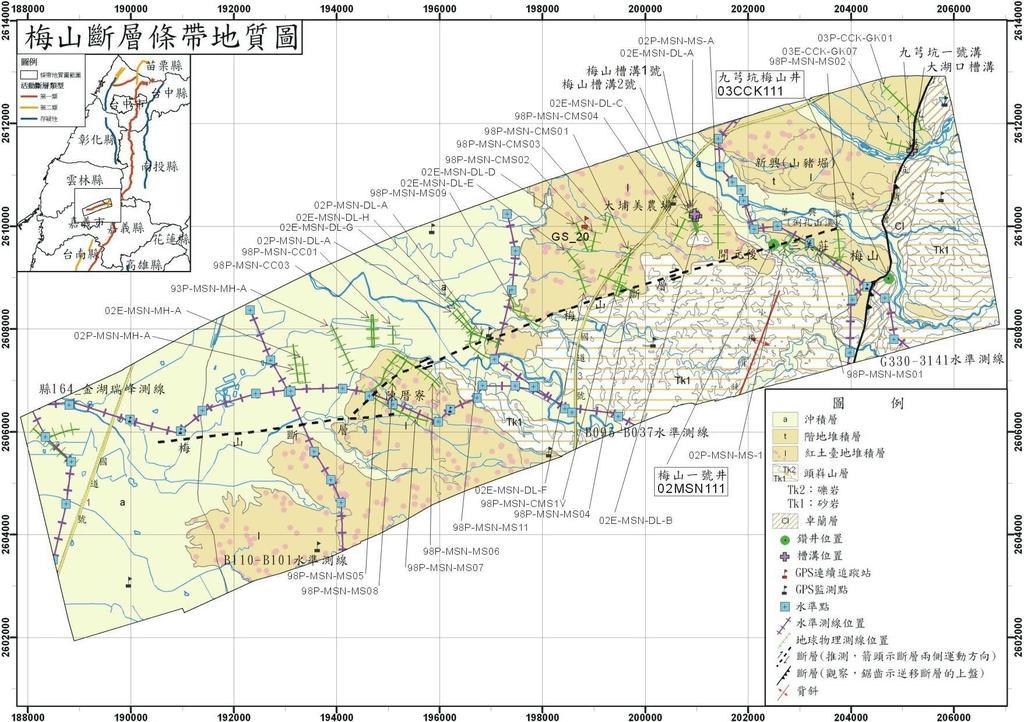
13 The Strip Map of Active Faults (1/25,000) 13


14 The Strip Map of Active Faults (1/25,000) Southwestern Taiwan Central Taiwan Northern Taiwan Eastern and Southern Taiwan 14

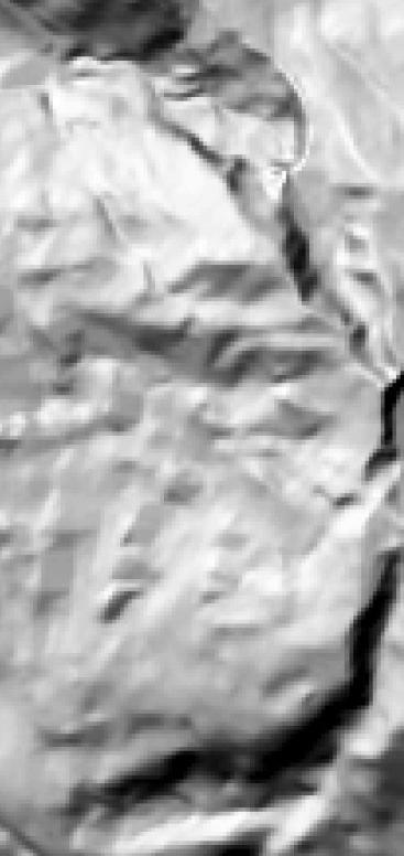
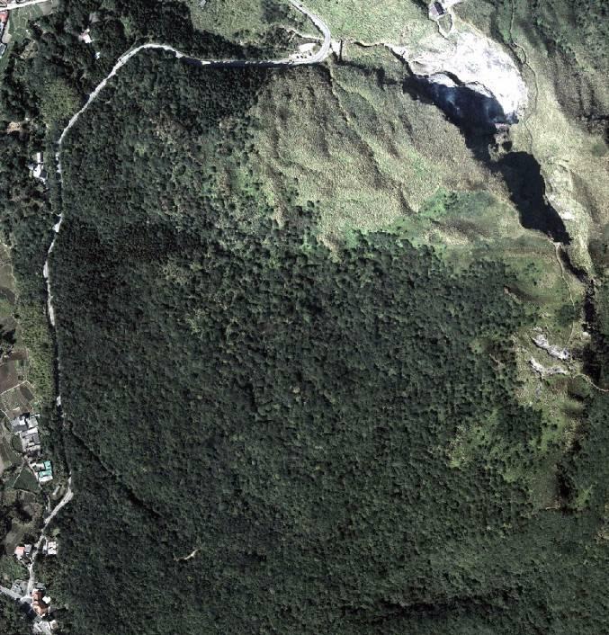
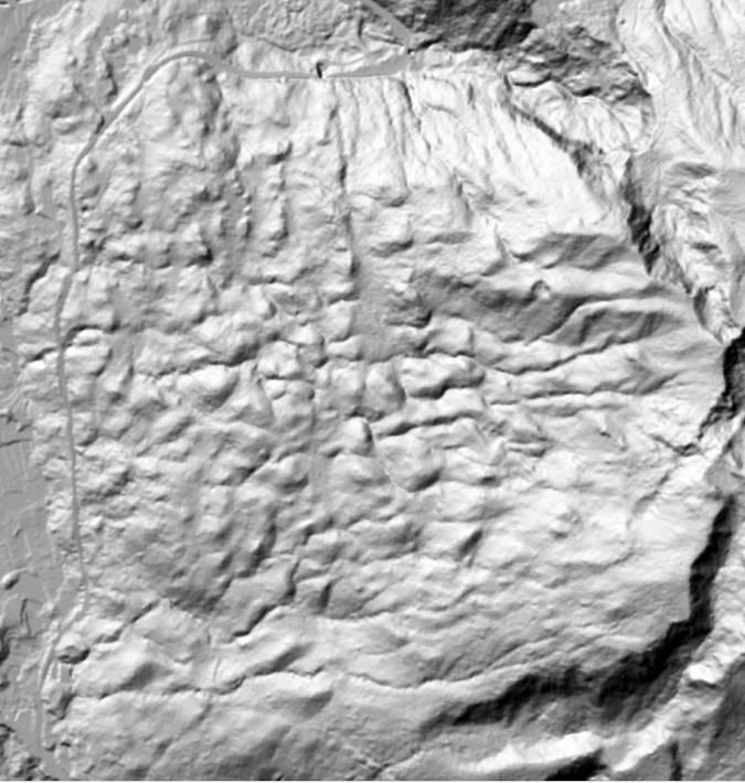
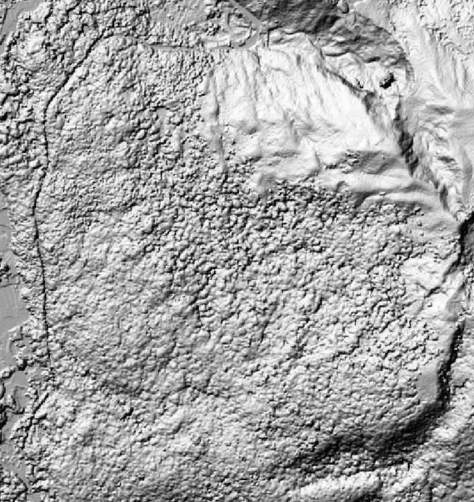
15 LiDAR-derived Images: Clarity of Bare Ground 40m DEM 5 m DEM Airphoto 400 m 15


16 Fault Scarps are greatly enhanced after striping the vegetation 16


17 Mapping faults using the shading map derived from SW LiDAR NE 斷層泥 Average vertical displacement: 3.3 m N 100m 17


18 Paleoseismologic study 9 trenches have been excavated along the Chelungpu fault after the Chi-Chi earthquake. 16 active faults have been trenched in the past decade. 18


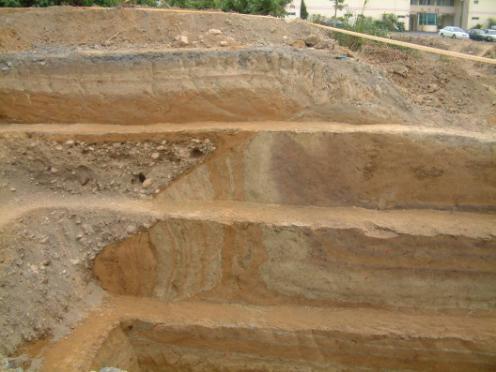
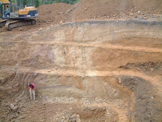
19 Northern wall Southern wall 19

20 Reconstruction of Paleoseismic Events of the Chelungpu fault 20
21 The movement of the Chelungpu fault is time-predicable, but what about the others? 21


22 Parameters of active faults in Taiwan f. name Sense of movement dip Vertical displacement Longterm slip rate Recurrence interval Elapse time 22
23 Outline Plate tectonic setting and historical earthquake disasters of Taiwan Geologic investigation of active faults Detail active fault mapping Fault geometry Paleoseismologic study Crustal deformation observation GPS crustal deformation monitoring Precise leveling survey across active faults Earthquake precursors research Geochemical monitoring Groundwater pressure, and Borehole strainmeter measurement Concluding remarks 23


24 GPS Stations 70 continuous GPS stations have been installed by CGS since continuous GPS stations installed by CWB (not shown on the map) 1000 Campaign-mode sites have been established and have been occupied once annually Continuous GPS station Campaign GPS station 24


25 Precise Leveling across active faults 41 precise leveling lines, summing up to 1000km length, have been deployed across active faults. Occupied once per year To monitor the relative displacements across active faults and estimate the short-term slip rate of the faults Precise Leveling Measurement 25


26 Horizontal velocity field of Taiwan The Coastal Range and the southwestern Taiwan are highly deformed. Eastern : mm/yr northwestward. Southern : mm/yr westward. Central & Northern : < 10 mm/yr. Sharp contrast between Coastal Range and Central Range Sharp contrast across the active fault zone in southwestern Taiwan 26 horizontal velocity field (2002~2010)


27 Vertical Deformation revealed by CGPS and precise leveling Max. ~2 cm/yr Max. ~2.9 cm/yr 27 Four precise leveling campaigns from 2000 to 2008: > 4000 km in leveling lines Chen et al. 2009

28 Strain Rate Field of Taiwan,
29 Outline Plate tectonic setting and historical earthquake disasters of Taiwan Geologic investigation of active faults Detail active fault mapping Fault geometry Paleoseismologic study Crustal deformation observation GPS ground surface displacement monitoring Precise leveling survey across active faults Earthquake precursor research Geochemical monitoring Groundwater pressure, and Borehole strainmeter measurement Concluding remarks 29
30 Geochemical Monitoring Fu et al. (2009) 30 Fu et al. (2009)
 古坑站 (GK) 中崙站 (CL) 二溪站 (RS) 屏科大 (PT) 蘇澳 (SA) 美崙 (ML) 池上 (CS) 2 groundwater radon stations: 安通 (AT) 社頂 (SD) Soil gas geochemical station")
31 Geochemical stations of radon 10 geochemical stations have been installed in the vicinity of active faults 8 soil-gas radon stations: 大平地 (TPT) 古坑站 (GK) 中崙站 (CL) 二溪站 (RS) 屏科大 (PT) 蘇澳 (SA) 美崙 (ML) 池上 (CS) 2 groundwater radon stations: 安通 (AT) 社頂 (SD) Soil gas geochemical station 31
32 Precursor model of observatory network Each station has its own earthquake-sensitive zone The intersection of different sensitive zones will be the area where the expected seismic event may occur in the coming 2 weeks. 32
33 The correlation between radon observation and seismic events After several years observation, earthquake sensitive zone for each station has preliminarily been outlined. If anomalies appear in several stations the expected event may occurred in the intersection area of their sensitive zones. The radon anomalies for 6 major events of M L >5 have been recorded in multiple stations since the end of 2009: 11/05/2009, Nantou, M L = 6.2, stations with radon anomaly: TPT, CL, CS 12/19/2009, Hualien, M L = 6.9, stations with radon anomaly : TPT, CL, CS 1/19/2010, Hualien, M L = 5.6, stations with radon anomaly : CL, CS 2/12/2010, Nantou, M L = 5.2, stations with radon anomaly : TPT, GK, CL, CS 03/04/2010, Kaohsiung, M L = 6.4, stations with radon anomaly : GK, CL, PT, CS 11/21/2010, Hualien, M L = 6.1, stations with radon anomaly : TPT, CS 33
34 Radon anomalies observed prior to 03/04/2010 earthquake 0304 earthquake 2 weeks before , radon anomalies had been detected in GK, CL, CC, and CS stations. Yunlin, Gukeng SA Chiayi, Chunglun Pingtung, Chaochou 34 Taitung, Chinshang


35 Borehole Strainmeter Stations 13 borehole strainmeter observatories have been installed in western Taiwan by CGS since installed in eastern Taiwan for PBO by IES, Academia Sinica GTSM: Gladwin Tensor Strainmeter 35
36 Water head, m Water head, m hourly rainfall, mm Water head, m hourly rainfall, mm Water Head, m hourly rainfall, mm Researches on other earthquake precursors 0304-earthquake 84 TSUN 0304-earthquake TSUN water head change /2/10 1/22/10 2/11/10 3/3/10 3/23/10 48 TAIS TAIS water head change The strainmeter record in Chiayi area The pre-seismic and co-seismic strain variations had been recorded in RST, RNT, DARB, TAIS and TSUN The groundwater piezometers, co-site with strainmeter, showed only coseismic water level change, but without apparent anomalies prior to the earthquake /2/10 1/22/10 2/11/10 3/3/10 3/23/10 DARB water head change /2/10 1/22/10 2/11/10 3/3/10 3/23/ DARB YS YS water head change Groundwater record in Chiayi area 1/2/10 1/22/10 2/11/10 3/3/10 3/23/10 36
37 Concluding remarks A precise active fault maps are essential for seismic hazard mitigation and the LiDAR-derived imageries can greatly improve the precision and accuracy of active fault investigation. GPS observation and leveling survey should be persisted to monitor the crustal deformation in the vicinity of active faults as well as the whole island. The radon anomalies observed in recent years have been correlated with the seismic events of the magnitude greater than 5. It is also possible to determine the precursory time and location of an upcoming earthquake. The correlation between magnitude and radon variation has not well established yet. Joint observation of different precursors such as variations of foreshocks, radon emission, groundwater level, strain, ground displacement, etc. may provide an opportunity for successful prediction of an earthquake. 37


38 Long-term potential evaluation of fault-source earthquakes Evaluating the probabilities of large-scale earthquakes for each active fault is one of our next major assignments in active fault research. San Francisco bay area, USA Japan 38
39 ~Thanks for Your Attention~ 39
Chapter 2. Earthquake and Damage
 EDM Report on the Chi-Chi, Taiwan Earthquake of September 21, 1999 2.1 Earthquake Fault 2.1.1 Tectonic Background The island of Taiwan is located in the complex junction where the Eurasian and Philippine
ESTIMATES OF HORIZONTAL DISPLACEMENTS ASSOCIATED WITH THE 1999 TAIWAN EARTHQUAKE
 ESTIMATES OF HORIZONTAL DISPLACEMENTS ASSOCIATED WITH THE 1999 TAIWAN EARTHQUAKE C. C. Chang Department of Surveying and Mapping Engineering Chung Cheng Institute of Technology, Taiwan, ROC ABSTRACT A
Plate Boundary Observatory Working Group for the Central and Northern San Andreas Fault System PBO-WG-CNSA
 Plate Boundary Observatory Working Group for the Central and Northern San Andreas Fault System PBO-WG-CNSA Introduction Our proposal focuses on the San Andreas fault system in central and northern California.
Lessons from the 2004 Sumatra earthquake and the Asian tsunami
 Lessons from the 2004 Sumatra earthquake and the Asian tsunami Kenji Satake National Institute of Advanced Industrial Science and Technology Outline 1. The largest earthquake in the last 40 years 2. Tsunami
News Release December 30, 2004 The Science behind the Aceh Earthquake
 News Release December 30, 2004 The Science behind the Aceh Earthquake PASADENA, Calif. - Kerry Sieh, the Robert P. Sharp Professor of Geology at the California Institute of Technology and a member of Caltech's
TEGAM s Connection to the EarthScope Project
 TEGAM s Connection to the EarthScope Project Introduction The EarthScope Project is an undertaking funded by the National Science Foundation in partnership with the United States Geological Survey and
Lateral extrusion and tectonic escape in Ilan Plain of northeastern Taiwan
 Lateral extrusion and tectonic escape in Ilan Plain of northeastern Taiwan Angelier, J., Chang, T.Y., Hu, J.C., Chang, C.P., Siame, L., Lee, J.C., Deffontaines, B., Chu, H.T, Lu, C.Y., Does extrusion occur
The Tectonic Setting of New Zealand
 The Tectonic Setting of New Zealand we are here Subduction-driven tectonics The New Zealand continent Papua New Guinea Australia 3,000,000 sq km micro-continent back-arc basin trench volcanism faults accretionary
The potential tsunami threats from the South China Sea and hazard mitigation
 The potential tsunami threats from the South China Sea and hazard mitigation Dr. Tso-Ren Wu ( 吳祚任 ) Graduate Institute of Hydrological and Oceanic Sciences National Central University 國立中央大學水文與海洋科學研究所
Foreshock Characteristics in Taiwan: Potential Earthquake Warning
 Foreshock Characteristics in Taiwan: Potential Earthquake Warning Cheng-Horng Lin Institute of Earth Sciences, Academia Sinica 2010/9/14 Outline Foreshocks and potential applications Previous foreshock
The Chi-Chi,Taiwan Earthquake: Large Surface Displacements on an Inland Thrust Fault
 Eos, Vol. 80, No. 50, December 14,1999 EOS, TRANSACTIONS, AMERICAN GEOPHYSICAL UNION VOLUME 80 NUMBER 50 DECEMBER 14,1999 PAGES 605 620 The Chi-Chi,Taiwan Earthquake: Large Surface Displacements on an
Earthquakes. Earthquake Magnitudes 10/1/2013. Environmental Geology Chapter 8 Earthquakes and Related Phenomena
 Environmental Geology Chapter 8 Earthquakes and Related Phenomena Fall 2013 Northridge 1994 Kobe 1995 Mexico City 1985 China 2008 Earthquakes Earthquake Magnitudes Earthquake Magnitudes Richter Magnitude
Coseismic displacements and slip distribution from GPS and leveling observations for the 2006 Peinan earthquake (M w 6.1) in southeastern Taiwan
 in southeastern Taiwan") Earth Planets Space, 61, 299 318, 2009 Coseismic displacements and slip distribution from GPS and leveling observations for the 2006 Peinan earthquake (M w 6.1) in southeastern Taiwan Horng-Yue Chen 1,
Earth Planets Space, 61, 299 318, 2009 Coseismic displacements and slip distribution from GPS and leveling observations for the 2006 Peinan earthquake (M w 6.1) in southeastern Taiwan Horng-Yue Chen 1,
S. Toda, S. Okada, D. Ishimura, and Y. Niwa International Research Institute of Disaster Science, Tohoku University, Japan
 The first surface-rupturing earthquake in 20 years on a HERP major active fault: Mw=6.2 2014 Nagano, Japan, event along the Itoigawa-Shizuoka Tectonic Line is not characteristic S. Toda, S. Okada, D. Ishimura,
Lab 9: Satellite Geodesy (35 points)
") Lab 9: Satellite Geodesy (35 points) Here you will work with GPS Time Series data to explore plate motion and deformation in California. This lab modifies an exercise found here: http://www.unavco.org:8080/cws/pbonucleus/draftresources/sanandreas/
Lab 9: Satellite Geodesy (35 points) Here you will work with GPS Time Series data to explore plate motion and deformation in California. This lab modifies an exercise found here: http://www.unavco.org:8080/cws/pbonucleus/draftresources/sanandreas/
20 mm/yr mm/yr BERI DTCH MRDR. WHAL Atka AFZ
 Coupling, Slip Partitioning and Arc Deformation Along the Aleutian Subduction zone M. Wyss, H. Avé Lallemant, D. Christensen, J. Freymueller, R. Hansen, P Haeussler, K. Jacob, M. Kogan, S. McNutt, J. Oldow,
Neotectonic Implications between Kaotai and Peinanshan
 Neotectonic Implications between Kaotai and Peinanshan Abstract Longitudinal Valley was the suture zone between the Philippine Sea plate and the Eurasia plate. Peinanshan was the southest segment of the
to: Interseismic strain accumulation and the earthquake potential on the southern San
 Supplementary material to: Interseismic strain accumulation and the earthquake potential on the southern San Andreas fault system by Yuri Fialko Methods The San Bernardino-Coachella Valley segment of the
Seismic Quiescence before the 1999 Chi-Chi, Taiwan, M w 7.6 Earthquake
 Bulletin of the Seismological Society of America, Vol. 96, No. 1, pp. 321 327, February 2006, doi: 10.1785/0120050069 Seismic Quiescence before the 1999 Chi-Chi, Taiwan, M w 7.6 Earthquake by Yih-Min Wu
Preliminary Study of Possible Tsunami Hazards in Taiwan Region
 Preliminary Study of Possible Tsunami Hazards in Taiwan Region Xiaoming Wang and Philip L.-F. Liu Cornell University (First Draft on May 25 2006) (Second Draft on June 1 2006) (Final Update on June 8 2006)
Yellowstone Hotspot Component of the Plate Boundary Observatory
 Yellowstone Hotspot Component of the Plate Boundary Observatory (Investigators: Smith, Thatcher, Meertens, Humphreys, Dzurisin, Oldow Co-Investigators: Christiansen, Doss, Schwartz, Machette, Wong, Olig,
Lithological control on the spatial evolution of fault slip on the Longitudinal Valley Fault, Taiwan - Supplementary materials
 Lithological control on the spatial evolution of fault slip on the Longitudinal Valley Fault, Taiwan - Supplementary materials May 23, 2014 S.1 Seismicity The Longitudinal Valley Fault (LVF) is known to
Sendai Earthquake NE Japan March 11, Some explanatory slides Bob Stern, Dave Scholl, others updated March
 Sendai Earthquake NE Japan March 11, 2011 Some explanatory slides Bob Stern, Dave Scholl, others updated March 14 2011 Earth has 11 large plates and many more smaller ones. Plates are 100-200 km thick
Measurements in the Creeping Section of the Central San Andreas Fault
 Measurements in the Creeping Section of the Central San Andreas Fault Introduction Duncan Agnew, Andy Michael We propose the PBO instrument, with GPS and borehole strainmeters, the creeping section of
GPS Strain & Earthquakes Unit 5: 2014 South Napa earthquake GPS strain analysis student exercise
 GPS Strain & Earthquakes Unit 5: 2014 South Napa earthquake GPS strain analysis student exercise Strain Analysis Introduction Name: The earthquake cycle can be viewed as a process of slow strain accumulation
MAR110 Lecture #5 Plate Tectonics-Earthquakes
 1 MAR110 Lecture #5 Plate Tectonics-Earthquakes Figure 5.0 Plate Formation & Subduction Destruction The formation of the ocean crust from magma that is upwelled into a pair of spreading centers. Pairs
Precise Leveling Survey at the Yuli fault, Southeast Taiwan. and Cheng-Hong Lin
 No.44 2009 pp.159 166 Jui-Jen Lin Hsin-Chieh Pu Wen-Shan Chen and Cheng-Hong Lin Precise Leveling Survey at the Yuli fault, Southeast Taiwan Masayuki Murase, Nobuhisa Matsuta, Jui-Jen Lin Hsin-Chieh Pu
Guidelines for Site-Specific Seismic Hazard Reports for Essential and Hazardous Facilities and Major and Special-Occupancy Structures in Oregon
 Guidelines for Site-Specific Seismic Hazard Reports for Essential and Hazardous Facilities and Major and Special-Occupancy Structures in Oregon By the Oregon Board of Geologist Examiners and the Oregon
Regional deformation and kinematics from GPS data
 Regional deformation and kinematics from GPS data Jessica Murray, Jerry Svarc, Elizabeth Hearn, and Wayne Thatcher U. S. Geological Survey Acknowledgements: Rob McCaffrey, Portland State University UCERF3
Magnitude 7.0 PAPUA, INDONESIA
 A 7.0 magnitude earthquake struck eastern Indonesia's mountainous West Papua province on Saturday but there were no immediate reports of casualties or damage. The region is sparsely populated. According
Elastic Rebound Theory
 Earthquakes Elastic Rebound Theory Earthquakes occur when strain exceeds the strength of the rock and the rock fractures. The arrival of earthquakes waves is recorded by a seismograph. The amplitude of
The neotectonic architecture of Taiwan and its implications for future large earthquakes
 The neotectonic architecture of Taiwan and its implications for future large earthquakes J. Bruce H. Shyu 1,*, Kerry Sieh 1, Yue-Gau Chen 2, Char-Shine Liu 3 1: Division of Geological and Planetary Sciences,
Seismogenic structure of 1935 Hsinchu-Taichung (M GR =7.1) earthquake, Miaoli, western Taiwan 1935 (M GR =7.1)
 earthquake, Miaoli, western Taiwan 1935 (M GR =7.1)") Seismogenic structure of 1935 Hsinchu-Taichung (M GR =7.1) earthquake, Miaoli, western Taiwan 1935 (M GR =7.1) Y.N. Nina Lin; Y.G. Chen; Y.M. Wu (Inst. of Geosciences, NTU); K.M. Yang (Exploration and
Seismogenic structure of 1935 Hsinchu-Taichung (M GR =7.1) earthquake, Miaoli, western Taiwan 1935 (M GR =7.1) Y.N. Nina Lin; Y.G. Chen; Y.M. Wu (Inst. of Geosciences, NTU); K.M. Yang (Exploration and
The March 11, 2011, Tohoku-oki earthquake (Japan): surface displacement and source modelling
: surface displacement and source modelling") The March 11, 2011, Tohoku-oki earthquake (Japan): surface displacement and source modelling Salvatore Stramondo Bignami C., Borgstrom S., Chini M., Guglielmino F., Melini D., Puglisi G., Siniscalchi V.,
The March 11, 2011, Tohoku-oki earthquake (Japan): surface displacement and source modelling Salvatore Stramondo Bignami C., Borgstrom S., Chini M., Guglielmino F., Melini D., Puglisi G., Siniscalchi V.,
National Seismological Centre: An Overview, Prospects and Challenges
 National Seismological Centre: An Overview, Prospects and Challenges By Soma Nath Sapkota Department of Mines and Geology National Seismological Centre Nepal India Himalaya Tibetan Plateau India continental
Bonn, Germany MOUTAZ DALATI. General Organization for Remote Sensing ( GORS ), Syria Advisor to the General Director of GORS,
, Syria Advisor to the General Director of GORS,") Bonn, Germany Early Warning System is needed for Earthquakes disaster mitigation in Syria Case Study: Detecting and Monitoring the Active faulting zones along the Afro-Arabian-Syrian Rift System MOUTAZ
Bonn, Germany Early Warning System is needed for Earthquakes disaster mitigation in Syria Case Study: Detecting and Monitoring the Active faulting zones along the Afro-Arabian-Syrian Rift System MOUTAZ
PALEOSEISMOLOGY: SITES (17)
") GG 454 February 8, 2002 1 PALEOSEISMOLOGY: SITES (17) Schedule Updates and Reminders: Reading for this lecture: Big Picture - Skim "Applications" in PP 1360 Reading for next lecture: Handouts from Active
GG 454 February 8, 2002 1 PALEOSEISMOLOGY: SITES (17) Schedule Updates and Reminders: Reading for this lecture: Big Picture - Skim "Applications" in PP 1360 Reading for next lecture: Handouts from Active
Scientific Research on the Cascadia Subduction Zone that Will Help Improve Seismic Hazard Maps, Building Codes, and Other Risk-Mitigation Measures
 Scientific Research on the Cascadia Subduction Zone that Will Help Improve Seismic Hazard Maps, Building Codes, and Other Risk-Mitigation Measures Art Frankel U.S. Geological Survey Seattle, WA GeoPrisms-Earthscope
Three-dimensional V P and V S structural models associated with the active subduction and collision tectonics in the Taiwan region
 Geophys. J. Int. (2005) 162, 204 220 doi: 10.1111/j.1365-246X.2005.02657.x Three-dimensional V P and V S structural models associated with the active subduction and collision tectonics in the Taiwan region
The Earthquake of Padang, Sumatra of 30 September 2009 scientific information and update
 The Earthquake of Padang, Sumatra of 30 September 2009 scientific information and update 01-October-2009 Christophe Vigny Directeur de recherches at CNRS Laboratoire de Géologie Geoscience Dept. Of ENS,
Deformation of Rocks. Orientation of Deformed Rocks
 Deformation of Rocks Folds and faults are geologic structures caused by deformation. Structural geology is the study of the deformation of rocks and its effects. Fig. 7.1 Orientation of Deformed Rocks
Earthquakes. Building Earth s Surface, Part 2. Science 330 Summer What is an earthquake?
 Earthquakes Building Earth s Surface, Part 2 Science 330 Summer 2005 What is an earthquake? An earthquake is the vibration of Earth produced by the rapid release of energy Energy released radiates in all
A two-dimensional dislocation model for interseismic deformation of the Taiwan mountain belt
 R Available online at www.sciencedirect.com Earth and Planetary Science Letters 211 (2003) 287^294 www.elsevier.com/locate/epsl A two-dimensional dislocation model for interseismic deformation of the Taiwan
GEO-VIII November Geohazard Supersites and Natural Laboratories Progress Report. Document 9
 GEO-VIII 16-17 November 2011 Geohazard Supersites and Natural Laboratories Progress Report Document 9 This document is submitted to GEO-VIII for information. Geohazard Supersites and Natural Laboratories
Jocelyn Karen Campbell
 THE UNCERTAINTIES IN ASSESSING THE IMPACT OF REGIONAL SEISMICITY AT THE WIL SITE Statement of Evidence by Jocelyn Karen Campbell A CANTERBURY FAULTS coded by type CHARACTERISTICS OF THRUST FAULTS IN CANTERBURY
Crustal Boundaries. As they move across the asthenosphere and form plate boundaries they interact in various ways. Convergent Transform Divergent
 Name: Date: Period: Plate Tectonics The Physical Setting: Earth Science CLASS NOTES Tectonic plates are constantly moving and interacting As they move across the asthenosphere and form plate boundaries
Earthquake Doublet Sequences: Evidence of Static Triggering in the Strong Convergent Zones of Taiwan
 Terr. Atmos. Ocean. Sci., Vol. 19, No. 6, 589-594, December 2008 doi: 10.3319/TAO.2008.19.6.589(PT) Earthquake Doublet Sequences: Evidence of Static Triggering in the Strong Convergent Zones of Taiwan
Case study of Japan: Reference Frames in Practice
 Case study of Japan: Reference Frames in Practice Basara Miyahara and Koji Matsuo Sponsors: 1 Outline Introduction - Geodetic reference frame of Japan - GEONET : continuous GNSS observation system Geometric
Strong, Wen (Shih Chung Wen, 溫士忠 ) TEL: ext FAX:
 TEL: ext FAX:") Strong, Wen (Shih Chung Wen, 溫士忠 ) TEL: +886-5-2720411 ext. 61212 FAX: +886-6-2720807 E-mail: strong@eq.ccu.edu.tw strong6212@gmail.com [Education] Ph.D., Institute of Seismology, National Chung Cheng
Strong, Wen (Shih Chung Wen, 溫士忠 ) TEL: +886-5-2720411 ext. 61212 FAX: +886-6-2720807 E-mail: strong@eq.ccu.edu.tw strong6212@gmail.com [Education] Ph.D., Institute of Seismology, National Chung Cheng
John Baldwin and Brian Gray Lettis Consultants International, Inc. Alexis Lavine AMEC Josh Goodman and Janet Sowers Fugro Consultants, Inc.
 John Baldwin and Brian Gray Lettis Consultants International, Inc. Alexis Lavine AMEC Josh Goodman and Janet Sowers Fugro Consultants, Inc. December 1, 2011 Pacific Gas & Electric SSHAC Workshop 1 San
A viscoelastic earthquake cycle model for Taiwan
 JOURNAL OF GEOPHYSICAL RESEARCH, VOL. 110,, doi:10.1029/2004jb003516, 2005 A viscoelastic earthquake cycle model for Taiwan K. M. Johnson 1 and P. Segall Department of Geophysics, Stanford University,
Development of a Predictive Simulation System for Crustal Activities in and around Japan - II
 Development of a Predictive Simulation System for Crustal Activities in and around Japan - II Project Representative Mitsuhiro Matsu'ura Graduate School of Science, The University of Tokyo Authors Mitsuhiro
What scientists know and do not know about the big one at Cascadia
 What scientists know and do not know about the big one at Cascadia Kelin Wang Pacific Geoscience Centre, Geological Survey of Canada Natural Resources Canada The Cascadia Subduction Zone M 7.3, 1946 Rupture
Earth s Tectonic Plates
 MASTER 49 6.2 3.7 5.4 Philippine Pacific 5.4 North American Juan de Fuca Caribbean Cocos 10.0 9.2 2.3 2.5 2.3 1.8 3.0 Indian-Australian 10.5 7.1 17.2 16.8 6.0 Nazca South American 11.1 10.3 7.3 3.7 7.5
Coseismic Surface GPS Displacement and Ground Shaking Associated with the 2006 Pingtung Earthquake Doublet, Offshore Southern Taiwan
 Terr. Atmos. Ocean. Sci., Vol. 19, No. 6, 683-696, December 2008 doi: 10.3319/TAO.2008.19.6.683(PT) Coseismic Surface GPS Displacement and Ground Shaking Associated with the 2006 Pingtung Earthquake Doublet,
Earthquakes and Earthquake Hazards Earth - Chapter 11 Stan Hatfield Southwestern Illinois College
 Earthquakes and Earthquake Hazards Earth - Chapter 11 Stan Hatfield Southwestern Illinois College What Is an Earthquake? An earthquake is the vibration of Earth, produced by the rapid release of energy.
SONGS Seismic Research Projects
 SONGS Seismic Research Projects Energy Division Independent Peer Review Group September 21, 2012 Agenda Background Overview Project Support Permits, Approvals, and Reviews Schedule Use of Advanced Technologies
Earthquake prediction. Earthquake prediction: animals?
 Earthquake prediction Prediction: specifies that an earthquake of a specific magnitude will occur in a defined region during a particular period: There will be a M 7 or larger earthquake in southern California
Estimation of fracture porosity and permeability using radon as a tracer
 PROCEEDINGS, 44th Workshop on Geothermal Reservoir Engineering Stanford University, Stanford, California, February 11-13, 2019 SGP-TR-214 Estimation of fracture porosity and permeability using radon as
How GNSS CORS in Japan works for geodetic control and disaster mitigations
 ICG Working Group D Reference Frames, Timing and Applications How GNSS CORS in Japan works for geodetic control and disaster mitigations ICG11, Nov. 7-11, 2016, Sochi, Russia Hiromichi TSUJI Geodetic Observation
Title. Author(s)Heki, Kosuke. CitationScience, 332(6036): Issue Date Doc URL. Type. File Information. A Tale of Two Earthquakes
Heki, Kosuke. CitationScience, 332(6036): Issue Date Doc URL. Type. File Information. A Tale of Two Earthquakes") Title A Tale of Two Earthquakes Author(s)Heki, Kosuke CitationScience, 332(6036): 1390-1391 Issue Date 2011-06-17 Doc URL http://hdl.handle.net/2115/48524 Type article (author version) File Information
Title A Tale of Two Earthquakes Author(s)Heki, Kosuke CitationScience, 332(6036): 1390-1391 Issue Date 2011-06-17 Doc URL http://hdl.handle.net/2115/48524 Type article (author version) File Information
Bulletin of the Seismological Society of America, Vol. 97, No. 4, pp , August 2007, doi: /
 Bulletin of the Seismological Society of America, Vol. 97, No. 4, pp. 1370 1377, August 2007, doi: 10.1785/0120060226 Short Note Anomalous Pn Waves Observed in Eastern Taiwan: Implications of a Thin Crust
Active Tectonics. Earthquakes, Uplift, and Landscape. Edward A. Keller University of California, Santa Barbara
 Prentice Hall Earth Science Series SUB Gottingen 214 80416X, im ^, 2002 A 7883 lllllllilwii Active Tectonics Earthquakes, Uplift, and Landscape Second Edition V Edward A. Keller University of California,
Case Study of Japan: Crustal deformation monitoring with GNSS and InSAR
 Technical Seminar Reference Frame in Practice, Case Study of Japan: Crustal deformation monitoring with GNSS and InSAR Basara Miyahara miyahara-b96ip@milt.go.jp Geospatial Information Authority of Japan
Plate Boundary Observatory the first five years
 www.earthscope.org Plate Boundary Observatory the first five years Plate Boundary Observatory A Continental-Scale, Integrated Geodetic By the Numbers (2003 2008) Installed 891 permanent Global Positioning
Study on the feature of surface rupture zone of the west of Kunlunshan pass earthquake ( M S 811) with high spatial resolution satellite images
 with high spatial resolution satellite images") 48 2 2005 3 CHINESE JOURNAL OF GEOPHYSICS Vol. 48, No. 2 Mar., 2005,,. M S 811.,2005,48 (2) :321 326 Shan X J, Li J H, Ma C. Study on the feature of surface rupture zone of the West of Kunlunshan Pass
48 2 2005 3 CHINESE JOURNAL OF GEOPHYSICS Vol. 48, No. 2 Mar., 2005,,. M S 811.,2005,48 (2) :321 326 Shan X J, Li J H, Ma C. Study on the feature of surface rupture zone of the West of Kunlunshan Pass
Manila subduction zone
 Manila subduction zone Andrew T.S. Lin SSC TI Team Member Taiwan SSHAC Level 3 PSHA Study Workshop #3, June 19 23, 2017 Taipei, Taiwan 1 1 Manila subduction zone Hazard Contribution Geometry Setting interface
Long-term Crustal Deformation in and around Japan, Simulated by a 3-D Plate Subduction Model
 Long-term Crustal Deformation in and around Japan, Simulated by a 3-D Plate Subduction Model Chihiro Hashimoto (1) and Mitsuhiro Matsu ura (2) (1) Institute of Frontier Research for Earth Evolution, Japan
JOURNAL OF GEOPHYSICAL RESEARCH, VOL. 115, B03419, doi: /2009jb006397, 2010
 Click Here for Full Article JOURNAL OF GEOPHYSICAL RESEARCH, VOL. 115,, doi:10.1029/2009jb006397, 2010 Revealing coseismic displacements and the deformation zones of the 1999 Chi Chi earthquake in the
Earthquakes Earth, 9th edition, Chapter 11 Key Concepts What is an earthquake? Earthquake focus and epicenter What is an earthquake?
 1 2 3 4 5 6 7 8 9 10 Earthquakes Earth, 9 th edition, Chapter 11 Key Concepts Earthquake basics. "" and locating earthquakes.. Destruction resulting from earthquakes. Predicting earthquakes. Earthquakes
Depth (Km) + u ( ξ,t) u = v pl. η= Pa s. Distance from Nankai Trough (Km) u(ξ,τ) dξdτ. w(x,t) = G L (x,t τ;ξ,0) t + u(ξ,t) u(ξ,t) = v pl
 + u ( ξ,t) u = v pl. η= Pa s. Distance from Nankai Trough (Km) u(ξ,τ) dξdτ. w(x,t) = G L (x,t τ;ξ,0) t + u(ξ,t) u(ξ,t) = v pl") Slip history during one earthquake cycle at the Nankai subduction zone, inferred from the inversion analysis of levelling data with a viscoelastic slip response function Mitsuhiro Matsu'ura, Akira Nishitani
Slip history during one earthquake cycle at the Nankai subduction zone, inferred from the inversion analysis of levelling data with a viscoelastic slip response function Mitsuhiro Matsu'ura, Akira Nishitani
Working group. Study of the evolution of the seismic cycle of stress and strain to. Main areas of study. Research lines
 Study of the evolution of the seismic cycle of stress and strain to the El Salvador Fault Zone (ESFZ) Alejandra Staller Universidad Politécnica de Madrid Research group on Seismic Engineering Working group
Modelling Subduction Zone Seismogenic Hazards in Southeast Asia for Seismic Hazard Assessments
 Modelling Subduction Zone Seismogenic Hazards in Southeast Asia for Seismic Hazard Assessments Vicki-Ann Dimas 1,2 and Gary Gibson 3 1. Corresponding Author. Seismic Hazard Analyst, Seismology Research
Earthquakes Chapter 19
 Earthquakes Chapter 19 Does not contain complete lecture notes. What is an earthquake An earthquake is the vibration of Earth produced by the rapid release of energy Energy released radiates in all directions
Real Time Monitoring System for Megathrust Earthquakes and Tsunamis - Cabled Network System and Buoy System in Japan -
 Real Time Monitoring System for Megathrust Earthquakes and Tsunamis - Cabled Network System and Buoy System in Japan - 1 Subduction zones around the world Haiti Italy Turkey Tohoku Sichuan Taiwan Sumatra
THE DEVELOPMENT AND APPLICATION OF THE DISPATCH MODEL FOR MOBILE DEBRIS FLOW MONITORING STATION AT TYPHOON EVENT
 THE DEVELOPMENT AND APPLICATION OF THE DISPATCH MODEL FOR MOBILE DEBRIS FLOW MONITORING STATION AT TYPHOON EVENT Chao-Hsien Yeh 1*, Bing-Jean Lin 2, Yao-Min Fang 3, Hsian-Yuan Yin 4, Hua-wei Lu 5 ABSTRACT
Tsunami waves swept away houses and cars in northern Japan and pushed ships aground.
 Japan was struck by a magnitude 8.9 earthquake off its northeastern coast Friday. This is one of the largest earthquakes that Japan has ever experienced. In downtown Tokyo, large buildings shook violently
TSUNAMI AND EARTHQUAKE ACTIVITY IN INDONESIA *
 LOCAL TSUNAMI WARNING AND MITIGATION TSUNAMI AND EARTHQUAKE ACTIVITY IN INDONESIA * Nanang T. Puspito Department of Geophysics and Meteorology, Institute of Technology Bandung (ITB) Address: Jalan Ganeca
Earthquake Source. Kazuki Koketsu. Special Session: Great East Japan (Tohoku) Earthquake. Earthquake Research Institute, University of Tokyo
 Earthquake. Earthquake Research Institute, University of Tokyo") 2012/9/24 17:20-17:35 WCEE SS24.4 Special Session: Great East Japan (Tohoku) Earthquake Earthquake Source Kazuki Koketsu Earthquake Research Institute, University of Tokyo 1 Names and features of the earthquake
2012/9/24 17:20-17:35 WCEE SS24.4 Special Session: Great East Japan (Tohoku) Earthquake Earthquake Source Kazuki Koketsu Earthquake Research Institute, University of Tokyo 1 Names and features of the earthquake
The 1999 Taiwan Earthquake: A Proposed Stress-Focusing, Heel-Shaped Model
 Bulletin of the Seismological Society of America, 91, 5, pp. 1053 1061, October 2001 The 1999 Taiwan Earthquake: A Proposed Stress-Focusing, Heel-Shaped Model by Cheng-Horng Lin Abstract Stress focusing
Lecture 4: Earthquakes and Seismic Waves
 Lecture 4: Earthquakes and Seismic Waves Key Questions 1. What are the sources for EQs in the PNW? 2. What is a seismograph and seismogram? 3. What is the difference between Richter magnitudes and Mercalli
Site specific seismic hazard assessment a case study of Guanyin offshore wind farm 場址特定地震危害度評估 - 以觀音離岸風力發電廠為例
 Site specific seismic hazard assessment a case study of Guanyin offshore wind farm 場址特定地震危害度評估 - 以觀音離岸風力發電廠為例 Supervisor : Dr. Chyi-Tyi Lee and Dr. Kuo-Fong Ma Speaker : Jia-Cian Gao 2018/04/26 1 1. A
Captain s Tryouts 2017
 Captain s Tryouts 2017 Dynamic Planet Test Written by: Araneesh Pratap (Chattahoochee High School) Name: Date: Answer all questions on the answer sheet. Point values are given next to each question or
Predicting Earthquakes: The Mw9.0 Tohoku Earthquake and Historical Earthquakes in Northeastern Japan
 Int. J. Disaster Risk Sci. 2012, 3 (3): 155 162 doi:10.1007/s13753-012-0016-0 ARTICLE Predicting Earthquakes: The Mw9.0 Tohoku Earthquake and Historical Earthquakes in Northeastern Japan Jifu Liu 1, *
Full file at
 Chapter 2 PLATE TECTONICS AND PHYSICAL HAZARDS MULTIPLE-CHOICE QUESTIONS 1. What direction is the Pacific Plate currently moving, based on the chain of Hawaiian Islands with only the easternmost island
Earthquakes and Tsunamis
 Earthquakes and Tsunamis Kenji Satake Earthquake Research Institute University of Tokyo 1 Part I 2011 Tohoku earthquake and tsunami 2 Fukushima Dai ichi NPP accident Earthquake ground motion Reactors automatically
Seismic Activity near the Sunda and Andaman Trenches in the Sumatra Subduction Zone
 IJMS 2017 vol. 4 (2): 49-54 International Journal of Multidisciplinary Studies (IJMS) Volume 4, Issue 2, 2017 DOI: http://doi.org/10.4038/ijms.v4i2.22 Seismic Activity near the Sunda and Andaman Trenches
Determination of the seismicity and peak ground acceleration for Lombok Island: An evaluation on tectonic setting
 4 TH ICRMCE, SOLO, 11-12 JULY 2018 Determination of the seismicity and peak ground acceleration for Lombok Island: An evaluation on tectonic setting Didi S. Agustawijaya, Heri Sulistiyono, Ikhwan Elhuda
Crustal Deformation. (Building Earth s Surface, Part 1) Science 330 Summer Mapping geologic structures
 Science 330 Summer Mapping geologic structures") Crustal Deformation (Building Earth s Surface, Part 1) Science 330 Summer 2005 Mapping geologic structures When conducting a study of a region, a geologist identifies and describes the dominant rock structures
Crustal Deformation (Building Earth s Surface, Part 1) Science 330 Summer 2005 Mapping geologic structures When conducting a study of a region, a geologist identifies and describes the dominant rock structures
Landsat TM processing in the investigation of active fault zones, South Lajas Valley Fault Zone and Cerro Goden Fault Zone as an example
 Landsat TM processing in the investigation of active fault zones, South Lajas Valley Fault Zone and Cerro Goden Fault Zone as an example ANTONIO E. CAMERON-GONZÁLEZ 1 1 Department of Geology, University
Beneath our Feet: The 4 Layers of the Earty by Kelly Hashway
 Beneath our Feet: The 4 Layers of the Earty by Kelly Hashway The Earth is more than a giant ball made up of dirt, rocks, and minerals. The Earth may look like a giant ball from when looking at it from
Slip distributions of the 1944 Tonankai and 1946 Nankai earthquakes including the horizontal movement effect on tsunami generation
 Slip distributions of the 1944 Tonankai and 1946 Nankai earthquakes including the horizontal movement effect on tsunami generation Toshitaka Baba Research Program for Plate Dynamics, Institute for Frontier
Earth Science, (Tarbuck/Lutgens) Chapter 10: Mountain Building
 Chapter 10: Mountain Building") Earth Science, (Tarbuck/Lutgens) Chapter 10: Mountain Building 1) A(n) fault has little or no vertical movements of the two blocks. A) stick slip B) oblique slip C) strike slip D) dip slip 2) In a(n) fault,
Earth Science, (Tarbuck/Lutgens) Chapter 10: Mountain Building 1) A(n) fault has little or no vertical movements of the two blocks. A) stick slip B) oblique slip C) strike slip D) dip slip 2) In a(n) fault,
MAGMATIC, ERUPTIVE AND TECTONIC PROCESSES IN THE ALEUTIAN ARC, ALASKA
 MAGMATIC, ERUPTIVE AND TECTONIC PROCESSES IN THE ALEUTIAN ARC, ALASKA Introduction The Aleutian Arc contains roughly ten percent of the world s active volcanoes. Hardly a year goes by without a major eruption
Velocity-Interface Structure of the Southwestern Ryukyu Subduction Zone from EW OBS/MCS Data
 Marine Geophysical Researches 22: 265-287, 2001. 2002 Kluwer Academic Publishers. Printed in the Netherlands. Velocity-Interface Structure of the Southwestern Ryukyu Subduction Zone from EW9509-1 OBS/MCS
RELATION BETWEEN RAYLEIGH WAVES AND UPLIFT OF THE SEABED DUE TO SEISMIC FAULTING
 13 th World Conference on Earthquake Engineering Vancouver, B.C., Canada August 1-6, 24 Paper No. 1359 RELATION BETWEEN RAYLEIGH WAVES AND UPLIFT OF THE SEABED DUE TO SEISMIC FAULTING Shusaku INOUE 1,
DEFORMATION KINEMATICS OF TIBETAN PLATEAU DETERMINED FROM GPS OBSERVATIONS
 DEFORMATION KINEMATICS OF TIBETAN PLATEAU DETERMINED FROM GPS OBSERVATIONS Jinwei Ren Institute of Geology, China Seismological Bureau, Beijing 100029 China Tel: (10)62009095; Fax: (10)62009003; email:
Widespread Ground Motion Distribution Caused by Rupture Directivity during the 2015 Gorkha, Nepal Earthquake
 Widespread Ground Motion Distribution Caused by Rupture Directivity during the 2015 Gorkha, Nepal Earthquake Kazuki Koketsu 1, Hiroe Miyake 2, Srinagesh Davuluri 3 and Soma Nath Sapkota 4 1. Corresponding
RELOCATION OF THE MACHAZE AND LACERDA EARTHQUAKES IN MOZAMBIQUE AND THE RUPTURE PROCESS OF THE 2006 Mw7.0 MACHAZE EARTHQUAKE
 RELOCATION OF THE MACHAZE AND LACERDA EARTHQUAKES IN MOZAMBIQUE AND THE RUPTURE PROCESS OF THE 2006 Mw7.0 MACHAZE EARTHQUAKE Paulino C. FEITIO* Supervisors: Nobuo HURUKAWA** MEE07165 Toshiaki YOKOI** ABSTRACT
Coseismic Surface GPS Displacement and Ground Shaking Associated With the 2006 Pingtung Earthquake Doublet, Offshore Southern Taiwan
 Coseismic Surface GPS Displacement and Ground Shaking Associated With the 2006 Pingtung Earthquake Doublet, Offshore Southern Taiwan Horng-Yue Chen, Jian-Cheng Lee, Long-Chen Kuo, Shui-Beih Yu and Chi-Ching