S. Toda, S. Okada, D. Ishimura, and Y. Niwa International Research Institute of Disaster Science, Tohoku University, Japan
|
|
|
- Isaac Gilmore
- 6 years ago
- Views:
Transcription


1 The first surface-rupturing earthquake in 20 years on a HERP major active fault: Mw= Nagano, Japan, event along the Itoigawa-Shizuoka Tectonic Line is not characteristic S. Toda, S. Okada, D. Ishimura, and Y. Niwa International Research Institute of Disaster Science, Tohoku University, Japan Okada et al., 2015, Seismological Research Letters, Vol. 86, No.5

2 First authorized probabilistic seismic hazard map opened in 2005 (10 yr after the Kobe earthquake) 30-yr probabilities of JMA intensity VI lower (~MMI X) > 26% High Moderate 6% - 26% 3% - 6% 0.1% - 3% < 0.1% Paleoseismic trench Pacific Plate Philippine Sea Plate The Headquarters for Earthquake Research Promotion (HERP, 2005)
3 30-yr probs of characteristic earthquakes on major active fault zones The Headquarters for Earthquake Research Promotion (HERP, 2005)
4 30-yr probs of characteristic earthquakes on major active fault zones The Headquarters for Earthquake Research Promotion (HERP, 2005)
 active fault system Southern ISTL (W-dipping thrust) The Headquarters for Earthquake Research Promotion (HERP,")
5 30-yr probs of characteristic earthquakes on major active fault zones Northern ISTL (E-dipping thrust) Central ISTL (left-lateral slip) Itoigawa- Shizuoka Tectonic Line (ISTL) active fault system Southern ISTL (W-dipping thrust) The Headquarters for Earthquake Research Promotion (HERP, 2005)
6 30-yr probs of characteristic earthquakes on major active fault zones Mw=6.2 Nov. 22, 2014 Nagano-ken-hokubu earthquake (M=6.7) (JMA, 2014) Northern ISTL (E-dipping thrust) Central ISTL (left-lateral slip) Itoigawa- Shizuoka Tectonic Line (ISTL) active fault system Southern ISTL (W-dipping thrust) The Headquarters for Earthquake Research Promotion (HERP, 2005)

7 2014 Nagano-ken-hokubu earthquake struck mountainous areas JMA intensity 7 MMI 6+ 9~ Max. acceleration K-net Hakuba 598 gal Epicenter
8 2014 quake ruptured northern half of the Kamishiro fault, Itoigawa-Shizuoka Tectonic Line active fault system

9 2014 quake ruptured northern half of the Kamishiro fault, Itoigawa-Shizuoka Tectonic Line active fault system
10 2014 quake ruptured northern half of the Kamishiro fault, Itoigawa-Shizuoka Tectonic Line active fault system seismicity during a week prior to the Mw6.2
11 2014 quake ruptured northern half of the Kamishiro fault, Itoigawa-Shizuoka Tectonic Line active fault system Aftershocks during the first 1.5 months
12 2014 quake ruptured northern half of the Kamishiro fault, Itoigawa-Shizuoka Tectonic Line active fault system Aftershocks during the first 1.5 months first 24 hr

13 N S Stream

14 Downstream Courtesy of Yasuhira Aoyagi

15 More than 9 km of complex surface faulting occurred on the previously mapped Kamishiro fault


16 Satellite dir. Beam InSAR analyses show densely spaced fringes on the hanging wall side, suggesting westward or uplift movement Beam Satellite dir. 10 km Close to satellite Away from satellite Displacement between satellite and ground (cm)


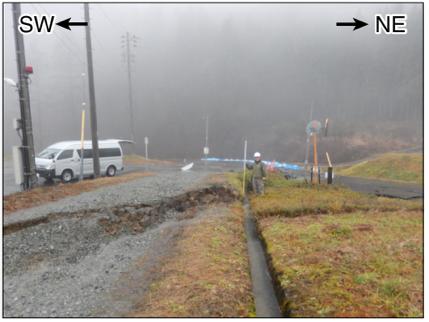
17 Vertical displacement to horizontal shortening N S Buckled object Contraction 30 cm Horinouchi Contraction 55 cm E W Contraction 40 cm Overlapped drainage gutter


18 Vertical displacement to horizontal shortening Contraction 30 cm Horinouchi Contraction 55 cm E W Contraction 40 cm
19 Why did the significant damage only occur at Horinouchi?
20 Why did the significant damage only occur at Horinouchi? Surface rupture


21 Why did the significant damage only occur at Horinouchi? Surface rupture


22 Loose and soft lacustrine sediment deposited in the paleo-kamishiro Lake on the hanging wall would be the reason Hakuba basin Okumura et al Kamishiro basin 2
23 Surface faulting transverses a residential area and caused serious damage to several houses

24 Surface faulting transverses a residential area and caused serious damage to several houses

25 Surface faulting transverses a residential area and caused serious damage to several houses
26 Predictability of rupture location by the pre-existing fault landforms 2014 rupture Sawa & Togo et al., 1999 Suzuki et al., 2010 Okada et al., 2015
27 Predictability of rupture location by the pre-existing fault landforms 2014 rupture Sawa & Togo et al., m Suzuki et al., 2010 Okada et al., 2015


28 Predictability of rupture location by the pre-existing fault landforms 2014 rupture Sawa & Togo et al., m Suzuki et al., 2010 Okada et al., 2015

29 The 2014 earthquake contributed to the growth of the up-hill facing scarp, part of which had been identified before the earthquake

30 Post-seismic geologic survey revealed frequent movements of the back-thrusts
31 Lacustrine sediments lower the fault dip and makes the rupture location unpredictable West Hakuba trench (Okumura et al., 1998; 2001) Tilted alluvial surface Restored topographic profile Flexure scarp 30 m East m a.s.l Artificial fill, paddy soil Lacustrine sand Black clay Peat, peaty clay Lacustrine silt Sand black clay 732 Gravel Fault
32 Lacustrine sediments lower the fault dip and makes the rupture location unpredictable 2014 rupture West Hakuba trench (Okumura et al., 1998; 2001) Tilted alluvial surface Restored topographic profile Flexure scarp 30 m East m a.s.l Artificial fill, paddy soil Lacustrine sand Black clay Peat, peaty clay Lacustrine silt Sand black clay 732 Gravel Fault

33 Deformed sediments indicate 1,000-1,500-yr recurrence intervals
34 We overestimated size of the earthquake on northern ISTL but large quakes on the ISTL might be much more frequent Geological Survey of Japan (2005) Suzuki et al. (2010) Headquarters for Earthquake Research Promotion (2013)
35 We overestimated size of the earthquake on northern ISTL but large quakes on the ISTL might be much more frequent Geological Survey of Japan (2005) Suzuki et al. (2010) Headquarters for Earthquake Research Promotion (2013) Observation (JMA, 2014)
36 Why did previous studies overestimate the size of the surface- rupturing earthquake? 1. Insufficient paleoseismic data lead us either overestimated the slip rate or overlooked some paleoseismic events. 2. Thinner seismogenic layer limits the size of large earthquakes but facilitates the surface faulting process. ~50,000 ybp ~70,000 ybp Tephra ~27,000 ybp Shimokawa & Yamazaki(1987)
37 Summary The 2014 Mw=6.2 Nagano earthquake is the first surfacerupturing earthquake to have occurred on the Itoigawa- Shizuoka Tectonic Line active fault system, one of the 110 major active faults evaluated by HERP since About 9-km-long surface rupture mostly reoccupied the fault scarp on the previously mapped 26-km-long Kamishiro fault, but half of the trace were not well predicted. The 2014 shock is not characteristic : There would be some diversity of large surface-breaking earthquakes not only on a long fault system but also on a single discrete fault segment.
Seismic Activity and Crustal Deformation after the 2011 Off the Pacific Coast of Tohoku Earthquake
 J-RAPID Symposium March 6-7, 2013 Seismic Activity and Crustal Deformation after the 2011 Off the Pacific Coast of Tohoku Earthquake Y. Honkura Tokyo Institute of Technology Japan Science and Technology
REPORT ON THE TOHOKU AREA PASIFIC OFFSHORE EARTHQUAKE
 REPORT ON THE TOHOKU AREA PASIFIC OFFSHORE EARTHQUAKE GENERAL PERSPECTIVE The Highest Magnitude Ever Recorded The 2011 off the Pacific Coast of Tohoku Earthquake (hereafter, the 2011 Tohoku- Pacific Earthquake
Earthquakes. Earthquake Magnitudes 10/1/2013. Environmental Geology Chapter 8 Earthquakes and Related Phenomena
 Environmental Geology Chapter 8 Earthquakes and Related Phenomena Fall 2013 Northridge 1994 Kobe 1995 Mexico City 1985 China 2008 Earthquakes Earthquake Magnitudes Earthquake Magnitudes Richter Magnitude
Earthquake Source. Kazuki Koketsu. Special Session: Great East Japan (Tohoku) Earthquake. Earthquake Research Institute, University of Tokyo
 Earthquake. Earthquake Research Institute, University of Tokyo") 2012/9/24 17:20-17:35 WCEE SS24.4 Special Session: Great East Japan (Tohoku) Earthquake Earthquake Source Kazuki Koketsu Earthquake Research Institute, University of Tokyo 1 Names and features of the earthquake
2012/9/24 17:20-17:35 WCEE SS24.4 Special Session: Great East Japan (Tohoku) Earthquake Earthquake Source Kazuki Koketsu Earthquake Research Institute, University of Tokyo 1 Names and features of the earthquake
PROBABILISTIC SEISMIC HAZARD MAPS AT GROUND SURFACE IN JAPAN BASED ON SITE EFFECTS ESTIMATED FROM OBSERVED STRONG-MOTION RECORDS
 13 th World Conference on Earthquake Engineering Vancouver, B.C., Canada August 1-6, 2004 Paper No. 3488 PROBABILISTIC SEISMIC HAZARD MAPS AT GROUND SURFACE IN JAPAN BASED ON SITE EFFECTS ESTIMATED FROM
Sendai Earthquake NE Japan March 11, Some explanatory slides Bob Stern, Dave Scholl, others updated March
 Sendai Earthquake NE Japan March 11, 2011 Some explanatory slides Bob Stern, Dave Scholl, others updated March 14 2011 Earth has 11 large plates and many more smaller ones. Plates are 100-200 km thick
San Andreas Movie Can It Happen?
 San Andreas Movie Can It Happen? Learning Objectives (LO) Lecture 14: Faults and Quakes Read: Chapter 10 and 11 Homework #12 due Thursday 12pm What we ll learn today:! 1. Compare strike-slip to dip-slip
New Seismic Activity Model of Large Earthquakes along Nankai Trough for Probabilistic Seismic Hazard Maps
 New Seismic Activity Model of Large Earthquakes along Nankai Trough for Probabilistic Seismic Hazard Maps Toshihiko Okumura (Shimizu Corp.) Hiroyuki Fujiwara (NIED) Plate Tectonics around Japan Pacific
SEISMIC HAZARD ASSESSMENT FOR JAPAN AFTER THE 2011 TOHOKU-OKI MEGA-THRUST EARTHQUAKE (Mw9.0)
") Proceedings of the International Symposium on Engineering Lessons Learned from the 2011 Great East Japan Earthquake, March 1-4, 2012, Tokyo, Japan SEISMIC HAZARD ASSESSMENT FOR JAPAN AFTER THE 2011 TOHOKU-OKI
Proceedings of the International Symposium on Engineering Lessons Learned from the 2011 Great East Japan Earthquake, March 1-4, 2012, Tokyo, Japan SEISMIC HAZARD ASSESSMENT FOR JAPAN AFTER THE 2011 TOHOKU-OKI
Magnitude 7.0 PAPUA, INDONESIA
 A 7.0 magnitude earthquake struck eastern Indonesia's mountainous West Papua province on Saturday but there were no immediate reports of casualties or damage. The region is sparsely populated. According
Active Tectonics. Earthquakes, Uplift, and Landscape. Edward A. Keller University of California, Santa Barbara
 Prentice Hall Earth Science Series SUB Gottingen 214 80416X, im ^, 2002 A 7883 lllllllilwii Active Tectonics Earthquakes, Uplift, and Landscape Second Edition V Edward A. Keller University of California,
Magnitude 7.1 NEAR THE EAST COAST OF HONSHU, JAPAN
 Japan was rattled by a strong aftershock and tsunami warning Thursday night nearly a month after a devastating earthquake and tsunami flattened the northeastern coast. This earthquake can be considered
Tohoku-oki event: Tectonic setting
 Tohoku-oki event: Tectonic setting This earthquake was the result of thrust faulting along or near the convergent plate boundary where the Pacific Plate subducts beneath Japan. This map also shows the
Part 2 - Engineering Characterization of Earthquakes and Seismic Hazard. Earthquake Environment
 Part 2 - Engineering Characterization of Earthquakes and Seismic Hazard Ultimately what we want is a seismic intensity measure that will allow us to quantify effect of an earthquake on a structure. S a
Earthquake. What is it? Can we predict it?
 Earthquake What is it? Can we predict it? What is an earthquake? Earthquake is the vibration (shaking) and/or displacement of the ground produced by the sudden release of energy. Rocks under stress accumulate
Chapter 2 Multivariate Statistical Analysis for Seismotectonic Provinces Using Earthquake, Active Fault, and Crustal Structure Datasets
 Chapter 2 Multivariate Statistical Analysis for Seismotectonic Provinces Using Earthquake, Active Fault, and Crustal Structure Datasets Takashi Kumamoto, Masataka Tsukada, and Masatoshi Fujita Abstract
Case Study of Japan: Crustal deformation monitoring with GNSS and InSAR
 Technical Seminar Reference Frame in Practice, Case Study of Japan: Crustal deformation monitoring with GNSS and InSAR Basara Miyahara miyahara-b96ip@milt.go.jp Geospatial Information Authority of Japan
Magnitude 6.3 SOUTH ISLAND OF NEW ZEALAND
 A magnitude 6.3 earthquake shook the southern New Zealand city of Christchurch. At least 100 people are reported dead, and there are reports of collapsed buildings, cracked streets and flooding due to
Jocelyn Karen Campbell
 THE UNCERTAINTIES IN ASSESSING THE IMPACT OF REGIONAL SEISMICITY AT THE WIL SITE Statement of Evidence by Jocelyn Karen Campbell A CANTERBURY FAULTS coded by type CHARACTERISTICS OF THRUST FAULTS IN CANTERBURY
Y. Shioi 1, Y. Hashizume 2 and H. Fukada 3
 Y. Shioi 1, Y. Hashizume 2 and H. Fukada 3 1 Emeritus Professor, Hachinohe Institute of Technology, Hachinohe, Japan 2 Chief Engineer, Izumo, Misawa, Aomori, Japan 3 Profesr, Geo-Technical Division, Fudo
Lecture # 6. Geological Structures
 1 Lecture # 6 Geological Structures ( Folds, Faults and Joints) Instructor: Dr. Attaullah Shah Department of Civil Engineering Swedish College of Engineering and Technology-Wah Cantt. 2 The wavy undulations
Author(s) Lin, Aiming; Sano, Mikako; Yan, Bin. Citation Tectonophysics (2015), 656:
 Lin, Aiming; Sano, Mikako; Yan, Bin. Citation Tectonophysics (2015), 656:") Co-seismic surface ruptures TitleNagano earthquake, along the produce Itoiga central Japan Author(s) Lin, Aiming; Sano, Mikako; Yan, Bin Citation Tectonophysics (2015), 656: 142-153 Issue Date 2015-08
Co-seismic surface ruptures TitleNagano earthquake, along the produce Itoiga central Japan Author(s) Lin, Aiming; Sano, Mikako; Yan, Bin Citation Tectonophysics (2015), 656: 142-153 Issue Date 2015-08
General Geologic Setting and Seismicity of the FHWA Project Site in the New Madrid Seismic Zone
 General Geologic Setting and Seismicity of the FHWA Project Site in the New Madrid Seismic Zone David Hoffman University of Missouri Rolla Natural Hazards Mitigation Institute Civil, Architectural & Environmental
Title fective Earthquake Risk Managemen. Author(s) Nigauri, Yasuhide, Miyata, Takao.
 Nigauri, Yasuhide, Miyata, Takao.") Kochi University of Technology Aca Importance of the Active Fault Re Title fective Earthquake Risk Managemen Author(s) Nigauri, Yasuhide, Miyata, Takao Society for Social Management Sys Citation ournal,
Kochi University of Technology Aca Importance of the Active Fault Re Title fective Earthquake Risk Managemen Author(s) Nigauri, Yasuhide, Miyata, Takao Society for Social Management Sys Citation ournal,
PREDICTION OF AVERAGE SHEAR-WAVE VELOCITY FOR GROUND SHAKING MAPPING USING THE DIGITAL NATIONAL LAND INFORMATION OF JAPAN
 th World Conference on Earthquake Engineering Vancouver, B.C., Canada August -6, 00 Paper No. 07 PREDICTION OF AVERAGE SHEAR-WAVE VELOCITY FOR GROUND SHAKING MAPPING USING THE DIGITAL NATIONAL LAND INFORMATION
Paleo and New Earthquakes and Evaluation of North Tabriz Fault Displacement in Relation to Recurrence Interval of Destructive Earthquakes
 Journal of Civil Engineering and Architecture 9 (2015) 1012-1016 doi: 10.17265/1934-7359/2015.08.013 D DAVID PUBLISHING Paleo and New Earthquakes and Evaluation of North Tabriz Fault Displacement in Relation
I. Locations of Earthquakes. Announcements. Earthquakes Ch. 5. video Northridge, California earthquake, lecture on Chapter 5 Earthquakes!
 51-100-21 Environmental Geology Summer 2006 Tuesday & Thursday 6-9:20 p.m. Dr. Beyer Earthquakes Ch. 5 I. Locations of Earthquakes II. Earthquake Processes III. Effects of Earthquakes IV. Earthquake Risk
Crustal deformation by the Southeast-off Kii Peninsula Earthquake
 Crustal deformation by the Southeast-off Kii Peninsula Earthquake 51 Crustal deformation by the Southeast-off Kii Peninsula Earthquake Tetsuro IMAKIIRE, Shinzaburo OZAWA, Hiroshi YARAI, Takuya NISHIMURA
Earth Science, (Tarbuck/Lutgens) Chapter 10: Mountain Building
 Chapter 10: Mountain Building") Earth Science, (Tarbuck/Lutgens) Chapter 10: Mountain Building 1) A(n) fault has little or no vertical movements of the two blocks. A) stick slip B) oblique slip C) strike slip D) dip slip 2) In a(n) fault,
Earth Science, (Tarbuck/Lutgens) Chapter 10: Mountain Building 1) A(n) fault has little or no vertical movements of the two blocks. A) stick slip B) oblique slip C) strike slip D) dip slip 2) In a(n) fault,
Chapter 2. Earthquake and Damage
 EDM Report on the Chi-Chi, Taiwan Earthquake of September 21, 1999 2.1 Earthquake Fault 2.1.1 Tectonic Background The island of Taiwan is located in the complex junction where the Eurasian and Philippine
Forces in Earth s Crust
 Name Date Class Earthquakes Section Summary Forces in Earth s Crust Guide for Reading How does stress in the crust change Earth s surface? Where are faults usually found, and why do they form? What land
crustal structure experiment beneath Wairarapa - Wellington area: results from SAHKE
 crustal structure experiment beneath Wairarapa - Wellington area: results from SAHKE Tim Stern and SAHKE team* * VUW, GNS, University of Southern California, University of Tokyo(Japan) SAHKE = Seismic
Borehole Strong Motion Observation along the Itoigawa-Shizuoka Tectonic Line
 Borehole Strong Motion Observation along the Itoigawa-Shizuoka Tectonic Line Hiroe Miyake, Minoru Sakaue & Kazuki Koketsu Earthquake Research Institute, University of Tokyo, Japan Yasuo Izutani Shinshu
Overview of Active Fault Research at Geological Survey of Japan
 Overview of Active Fault Research at Geological Survey of Japan Yasuo. AWATA and Toshikazu. YOSHIOKA Active Fault Research Center, Geological Survey of Japan, AIST UJNR, November 10, 2006, Tokushima 1
Widespread Ground Motion Distribution Caused by Rupture Directivity during the 2015 Gorkha, Nepal Earthquake
 Widespread Ground Motion Distribution Caused by Rupture Directivity during the 2015 Gorkha, Nepal Earthquake Kazuki Koketsu 1, Hiroe Miyake 2, Srinagesh Davuluri 3 and Soma Nath Sapkota 4 1. Corresponding
The Seismic Hazardscape of New Zealand
 The Seismic Hazardscape of New Zealand Mark Stirling Professor of Earthquake Science Introduction Plate tectonic setting of New Zealand Seismic hazards for University of Otago campuses Kaikoura earthquake
Earthquakes and Earth s Interior
 - What are Earthquakes? Earthquakes and Earth s Interior - The shaking or trembling caused by the sudden release of energy - Usually associated with faulting or breaking of rocks - Continuing adjustment
Scientific Research on the Cascadia Subduction Zone that Will Help Improve Seismic Hazard Maps, Building Codes, and Other Risk-Mitigation Measures
 Scientific Research on the Cascadia Subduction Zone that Will Help Improve Seismic Hazard Maps, Building Codes, and Other Risk-Mitigation Measures Art Frankel U.S. Geological Survey Seattle, WA GeoPrisms-Earthscope
Usually, only a couple of centuries of earthquake data is available, much shorter than the complete seismic cycle for most plate motions.
 Earthquake Hazard Analysis estimate the hazard presented by earthquakes in a given region Hazard analysis is related to long term prediction and provides a basis to expressed hazard in probabilistic terms.
The Impact of the 2010 Darfield (Canterbury) Earthquake on the Geodetic Infrastructure in New Zealand 1
 Earthquake on the Geodetic Infrastructure in New Zealand 1") The Impact of the 2010 Darfield (Canterbury) Earthquake on the Geodetic Infrastructure in New Zealand 1 Graeme BLICK, John BEAVAN, Chris CROOK, Nic DONNELLY Keywords: Darfield Earthquake, control, survey,
The Impact of the 2010 Darfield (Canterbury) Earthquake on the Geodetic Infrastructure in New Zealand 1 Graeme BLICK, John BEAVAN, Chris CROOK, Nic DONNELLY Keywords: Darfield Earthquake, control, survey,
Tsunami waves swept away houses and cars in northern Japan and pushed ships aground.
 Japan was struck by a magnitude 8.9 earthquake off its northeastern coast Friday. This is one of the largest earthquakes that Japan has ever experienced. In downtown Tokyo, large buildings shook violently
Science Starter. Describe in your own words what an Earthquake is and what causes it. Answer The MSL
 Science Starter Describe in your own words what an Earthquake is and what causes it. Answer The MSL WHAT IS AN EARTHQUAKE AND HOW DO WE MEASURE THEM? Chapter 8, Section 8.1 & 8.2 Looking Back Deserts Wind-shaped
Foundations on Deep Alluvial Soils
 Canterbury Earthquakes Royal Commission Hearings 25 October 2011, Christchurch GEO.CUB.0001.1-35.1 Foundations on Deep Alluvial Soils Misko Cubrinovski, Ian McCahon, Civil and Natural Resources Engineering,
The 2011 Tohoku earthquake and dams
 The 2011 Tohoku earthquake and dams N. Matsumoto & T. Sasaki Japan Dam Engineering Center, Japan T. Ohmachi Tokyo Institute of Technology, Japan ABSTRACT: The magnitude 9.0 Tohoku earthquake occurred on
GROUND SURFACE VISUALIZATION USING RED RELIEF IMAGE MAP FOR A VARIETY OF MAP SCALES
 GROUND SURFACE VISUALIZATION USING RED RELIEF IMAGE MAP FOR A VARIETY OF MAP SCALES T. Chiba a, B. Hasi a * a Asia Air Survey Co., Ltd., Kawasaki, Japan (has.baator, ta.chiba,)@ajiko.co.jp Commission II,
Department of Civil Engineering, Kyoto University, by Shunzo OKAMOTO, M. J. A., Sept.
 214 Proc. Japan Acad., 71, Ser. B (1995) [Vol. 71(B), Extremely High Damage Potential Comparison of the Hyogo-ken of Near Field Earthquake Ground Nanbu and the Northridge Earthquakes Motion By Hirokazu
Earthquake Hazards. Tsunami
 Earthquake Hazards Tsunami Review: What is an earthquake? Earthquake is the vibration (shaking) and/or displacement of the ground produced by the sudden release of energy. The point inside the Earth where
EARTHQUAKE LOCATIONS INDICATE PLATE BOUNDARIES EARTHQUAKE MECHANISMS SHOW MOTION
 6-1 6: EARTHQUAKE FOCAL MECHANISMS AND PLATE MOTIONS Hebgen Lake, Montana 1959 Ms 7.5 1 Stein & Wysession, 2003 Owens Valley, California 1872 Mw ~7.5 EARTHQUAKE LOCATIONS INDICATE PLATE BOUNDARIES EARTHQUAKE
CHAPTER 1 BASIC SEISMOLOGY AND EARTHQUAKE TERMINOLGY. Earth Formation Plate Tectonics Sources of Earthquakes...
 CHAPTER 1 BASIC SEISMOLOGY AND EARTHQUAKE TERMINOLGY Earth Formation... 1-2 Plate Tectonics... 1-2 Sources of Earthquakes... 1-3 Earth Faults... 1-4 Fault Creep... 1-5 California Faults... 1-6 Earthquake
Earthquake Hazards. Tsunami
 Earthquake Hazards Tsunami Review: What is an earthquake? Earthquake is the vibration (shaking) and/or displacement of the ground produced by the sudden release of energy. The point inside the Earth where
DYNAMIC DEFORMATION CHARACTERISTICS OF THE GROUND IDENTIFIED FROM SEISMIC OBSERVATIONS IN VERTICAL BOREHOLES
 DYNAMIC DEFORMATION CHARACTERISTICS OF THE GROUND IDENTIFIED FROM SEISMIC OBSERVATIONS IN VERTICAL BOREHOLES Tetsushi KURITA 1, Hiroshi SATO 2 and Tomomi ADACHI 3 ABSTRACT Parameter identification analysis
The Current Activities of the Headquarters for Earthquake Research Promotion Concerning Tonankai/Nankai Earthquakes
 The Current Activities of the Headquarters for Earthquake Research Promotion Concerning Tonankai/Nankai Earthquakes ISOGAI Keisuke Director of Earthquake Research Division, Research and Development Bureau,
Forces in the Earth s crust
 EARTHQUAKES Forces in the Earth s crust How does stress in the crust change Earth s surface? Where are faults usually found, and why do they form? What land features result from the forces of plate movement?
Case study of Japan: Reference Frames in Practice
 Case study of Japan: Reference Frames in Practice Basara Miyahara and Koji Matsuo Sponsors: 1 Outline Introduction - Geodetic reference frame of Japan - GEONET : continuous GNSS observation system Geometric
Earthquake Hazards. Tsunami
 Earthquake Hazards Tsunami Measuring Earthquakes Two measurements that describe the power or strength of an earthquake are: Intensity a measure of the degree of earthquake shaking at a given locale based
Earthquakes & Volcanoes
 Earthquakes & Volcanoes Geology - the study of solid Earth, the rocks of which it is composed, and the processes by which they change geo = Earth; ology = study of Earth s Layers Plate Tectonics - the
Zoning surface rupture hazard along normal faults: insight from the 2009 M w 6.3 L Aquila, central Italy, earthquake and other global earthquakes
 Zoning surface rupture hazard along normal faults: insight from the 2009 M w 6.3 L Aquila, central Italy, earthquake and other global earthquakes Boncio, P., Galli, P., Naso, G., Pizzi, A. Bulletin of
Lessons from the 2004 Sumatra earthquake and the Asian tsunami
 Lessons from the 2004 Sumatra earthquake and the Asian tsunami Kenji Satake National Institute of Advanced Industrial Science and Technology Outline 1. The largest earthquake in the last 40 years 2. Tsunami
2. Tsunami Source Details
 2. Tsunami Source Details The Northland area faces a range of potential tsunamigenic sources that include several local and distant fault systems and underwater landslides. A NIWA study (Goff et al. 2006)
4. Geotechnical and Geological Aspects. 4.1 Geotechnical Aspects
 4. Geotechnical and Geological Aspects 4.1 Geotechnical Aspects A preliminary reconnaissance of the geotechnical conditions of Duzce, Kaynasli, and Bolu urban areas was done during the Turkey Expedition
The March 11, 2011, Tohoku-oki earthquake (Japan): surface displacement and source modelling
: surface displacement and source modelling") The March 11, 2011, Tohoku-oki earthquake (Japan): surface displacement and source modelling Salvatore Stramondo Bignami C., Borgstrom S., Chini M., Guglielmino F., Melini D., Puglisi G., Siniscalchi V.,
The March 11, 2011, Tohoku-oki earthquake (Japan): surface displacement and source modelling Salvatore Stramondo Bignami C., Borgstrom S., Chini M., Guglielmino F., Melini D., Puglisi G., Siniscalchi V.,
Lab 9: Satellite Geodesy (35 points)
") Lab 9: Satellite Geodesy (35 points) Here you will work with GPS Time Series data to explore plate motion and deformation in California. This lab modifies an exercise found here: http://www.unavco.org:8080/cws/pbonucleus/draftresources/sanandreas/
Lab 9: Satellite Geodesy (35 points) Here you will work with GPS Time Series data to explore plate motion and deformation in California. This lab modifies an exercise found here: http://www.unavco.org:8080/cws/pbonucleus/draftresources/sanandreas/
Field Investigation and Dynamic Analysis of Damaged Structure on Pile Foundation during the 2011 off the Pacific Coast of Tohoku Earthquake
 Field Investigation and Dynamic Analysis of Damaged Structure on Pile Foundation during the 2011 off the Pacific Coast of Tohoku Earthquake Masatoshi Yamazoe Kobori Research Complex Inc., Japan Joji Sakuta
What Causes Rock to Deform?
 Crustal Deformation Earth, Chapter 10 Chapter 10 Crustal Deformation What Causes Rock to Deform? Deformation is a general term that refers to all changes in the shape or position of a rock body in response
THE 2011 TOHOKU EARTHQUAKE IN JAPAN. VSU Lyuben Karavelov, Sofia, Bulgaria. Key words: Tohoku earthquake, strong ground motion, damage
 THE 2011 TOHOKU EARTHQUAKE IN JAPAN Radan Ivanov 1 VSU Lyuben Karavelov, Sofia, Bulgaria Abstract: This earthquake which occurred on March 11, 2011, had a magnitude of 9.0, which places it as the fourth
Coulomb stress changes due to Queensland earthquakes and the implications for seismic risk assessment
 Coulomb stress changes due to Queensland earthquakes and the implications for seismic risk assessment Abstract D. Weatherley University of Queensland Coulomb stress change analysis has been applied in
PROBABILISTIC LIQUEFACTION HAZARD ANALYSIS IN JAPAN
 SECED 2015 Conference: Earthquake Risk and Engineering towards a Resilient World 9-10 July 2015, Cambridge UK PROBABILISTIC LIQUEFACTION HAZARD ANALYSIS IN JAPAN Tetsushi KURITA 1 and Sei ichiro FUKUSHIMA
log 4 0.7m log m Seismic Analysis of Structures by TK Dutta, Civil Department, IIT Delhi, New Delhi. Module 1 Seismology Exercise Problems :
 Seismic Analysis of Structures by TK Dutta, Civil Department, IIT Delhi, New Delhi. Module Seismology Exercise Problems :.4. Estimate the probabilities of surface rupture length, rupture area and maximum
Probabilistic Earthquake Risk Assessment of Newcastle and Lake Macquarie Part 1 Seismic Hazard.
 Probabilistic Earthquake Risk Assessment of Newcastle and Lake Macquarie Part 1 Seismic Hazard. T. Dhu, D. Robinson, C. Sinadinovski, T. Jones, A. Jones & J. Schneider Geoscience Australia, Canberra, Australia.
INTRODUCTION TO EARTHQUAKES
 INTRODUCTION TO EARTHQUAKES Seismology = Study of earthquakes Seismologists = Scientists who study earthquakes Earthquake = Trembling or shaking of the earth s surface, usually as a result of the movement
EQ Monitoring and Hazards NOTES.notebook. January 07, P-wave. S-wave. surface waves. distance
 Earthquake Monitoring and Hazards Reading a Seismogram General guidelines: P-wave First disruption of trace = Second disruption of trace = surface waves Largest disruption of trace = Not the distance to
Earthquakes and Tsunamis
 Earthquakes and Tsunamis Kenji Satake Earthquake Research Institute University of Tokyo 1 Part I 2011 Tohoku earthquake and tsunami 2 Fukushima Dai ichi NPP accident Earthquake ground motion Reactors automatically
RELOCATION OF THE MACHAZE AND LACERDA EARTHQUAKES IN MOZAMBIQUE AND THE RUPTURE PROCESS OF THE 2006 Mw7.0 MACHAZE EARTHQUAKE
 RELOCATION OF THE MACHAZE AND LACERDA EARTHQUAKES IN MOZAMBIQUE AND THE RUPTURE PROCESS OF THE 2006 Mw7.0 MACHAZE EARTHQUAKE Paulino C. FEITIO* Supervisors: Nobuo HURUKAWA** MEE07165 Toshiaki YOKOI** ABSTRACT
PALEOSEISMOLOGY: SITES (17)
") GG 454 February 8, 2002 1 PALEOSEISMOLOGY: SITES (17) Schedule Updates and Reminders: Reading for this lecture: Big Picture - Skim "Applications" in PP 1360 Reading for next lecture: Handouts from Active
GG 454 February 8, 2002 1 PALEOSEISMOLOGY: SITES (17) Schedule Updates and Reminders: Reading for this lecture: Big Picture - Skim "Applications" in PP 1360 Reading for next lecture: Handouts from Active
Tsunami potential and modeling
 Tsunami potential and modeling GEORGE PRIEST OREGON DEPT. OF GEOLOGY AND MINERAL INDUSTRIES NEWPORT COASTAL FIELD OFFICE April 7, 2012 GeoPRISMS Cascadia Workshop, Portland, Oregon What creates most uncertainty
STRUCTURE AND HOLOCENE SLIP OF THE JID FAULT, MONGOLIA ALTAI
 STRUCTURE AND HOLOCENE SLIP OF THE JID FAULT, MONGOLIA ALTAI LAURA K.O. SMITH AND SARAHTSETSEG PUREDORG Princeton University, Mongolian University of Science and Technology Sponsors: Ramon Gonzalez-Mieres
(First Edition: prepared on 29/12/2003)
") (First Edition: prepared on 29/12/2003) Dr Sassan Eshghi 1 and Dr Mehdi Zaré 2 International Institute of Earthquake Engineering and Seismology, Tehran, P.O.Box: 19395/3913, IRAN e-mails: 1)s.eshghi@iiees.ac.ir,
(First Edition: prepared on 29/12/2003) Dr Sassan Eshghi 1 and Dr Mehdi Zaré 2 International Institute of Earthquake Engineering and Seismology, Tehran, P.O.Box: 19395/3913, IRAN e-mails: 1)s.eshghi@iiees.ac.ir,
Earthquakes. Building Earth s Surface, Part 2. Science 330 Summer What is an earthquake?
 Earthquakes Building Earth s Surface, Part 2 Science 330 Summer 2005 What is an earthquake? An earthquake is the vibration of Earth produced by the rapid release of energy Energy released radiates in all
A palaeoseismological investigation of the Cadell Fault Zone, Victoria, Australia
 A palaeoseismological investigation of the Cadell Fault Zone, Victoria, Australia Amy Heath FM Global, Melbourne, Australia. Dan Clarke, Gary Gibson, Kevin McCue, Russ Van Dissen Geoscience Australia,
Magnitude 7.0 NEW CALEDONIA
 A magnitude 7.0 earthquake has occurred 82km ENE of Maré Island, the secondlargest of the Loyalty Islands in the archipelago of New Caledonia. The initial report of the magnitude and shallow 10km depth
Earthquake Damage Scenario
 Chapter 2. Earthquake Damage Scenario CHAPTER 2. EARTHQUAKE DAMAGE SCENARIO 2.1 Earthquake Scenario Setting and Ground Motion 2.1.1 Fault in the Philippines The Philippines is located in latitude 5 to
Crustal Deformation. (Building Earth s Surface, Part 1) Science 330 Summer Mapping geologic structures
 Science 330 Summer Mapping geologic structures") Crustal Deformation (Building Earth s Surface, Part 1) Science 330 Summer 2005 Mapping geologic structures When conducting a study of a region, a geologist identifies and describes the dominant rock structures
Crustal Deformation (Building Earth s Surface, Part 1) Science 330 Summer 2005 Mapping geologic structures When conducting a study of a region, a geologist identifies and describes the dominant rock structures
Magnitude 7.6 & 7.4 SOLOMON ISLANDS
 A magnitude 7.6 earthquake struck near the Solomon Islands on Sunday morning local time; there were no immediate reports of damage. The earthquake was centered 100 km (60 miles) south of Kira Kira, a town
Field Survey of Non-tectonic Surface Displacements Caused by the 2016 Kumamoto Earthquake Around Aso Valley
 Field Survey of Non-tectonic Surface Displacements Caused by the 2016 Kumamoto Earthquake Around Aso Valley 47 Field Survey of Non-tectonic Surface Displacements Caused by the 2016 Kumamoto Earthquake
KIRSTY STYLES - EARTHQUAKE RISK SCIENTIST
 Aspen Opinion 1 ASPEN OPINION STRESS STATE IN JAPAN TWO YEARS ON KIRSTY STYLES - EARTHQUAKE RISK SCIENTIST Kirsty Styles PhD, summarizes key academic papers on the topic of Coulomb Stress Transfer (CST)
Magnitude 7.0 VANUATU
 A major earthquake struck in the southwest Pacific Ocean at a depth of 27 km beneath the island of Melampa in the Vanuatu island chain. There are no reports of damage. The Modified Mercalli Intensity (MMI)
Scenario Earthquake Shaking Maps in Japan
 1 Scenario Earthquake Shaking Maps in Japan Nobuyuki Morikawa National Research Institute for Earth Science and Disaster Prevention (NIED), JAPAN Scenario Earthquake Shaking Maps (SESMs) The shaking maps
Chapter 16. Mountain Building. Mountain Building. Mountains and Plate Tectonics. what s the connection?
 Chapter 16 Mountains and Plate Tectonics what s the connection? Mountain Building Most crustal deformation occurs along plate margins. S.2 Active Margin Passive Margin Mountain Building Factors Affecting
Material Database of reflection surveys in Japan and pattern of active faults in seismic reflection profile
 Bull. of Yamagata Univ., Nat. Sci., Vol.15, No.4, Feb. 2004 Material Database of reflection surveys in Japan and pattern of active faults in seismic reflection profile Yosuke NAKAMURA, Akiko HASEMI, Tomotsugu
POTENTIAL SEISMICITY OF YANGON REGION (GEOLOGICAL APPROACH)
") Advances in Geosciences Vol. 26: Solid Earth (2010) Ed. Kenji Satake c World Scientific Publishing Company POTENTIAL SEISMICITY OF YANGON REGION (GEOLOGICAL APPROACH) HLA HLA AUNG Member, Myanmar Earthquake
Advances in Geosciences Vol. 26: Solid Earth (2010) Ed. Kenji Satake c World Scientific Publishing Company POTENTIAL SEISMICITY OF YANGON REGION (GEOLOGICAL APPROACH) HLA HLA AUNG Member, Myanmar Earthquake
Running Head: JAPANESE TSUNAMI 1. Geological Perspective of the Japanese Tsunami
 Running Head: JAPANESE TSUNAMI 1 Geological Perspective of the Japanese Tsunami JAPANESE TSUNAMI 2 JAPANESE TSUNAMI 3 Abstract Humanity is characterized with flaws, so is planet earth. Earthquakes shake
Overview of the Seismic Source Characterization for the Palo Verde Nuclear Generating Station
 Overview of the Seismic Source Characterization for the Palo Verde Nuclear Generating Station Scott Lindvall SSC TI Team Lead Palo Verde SSC SSHAC Level 3 Project Tuesday, March 19, 2013 1 Questions from
Tsunami and earthquake in Chile Part 2
 EUROPEAN COMMISSION DIRECTORATE GENERAL JRC JOINT RESEARCH CENTRE Institute for the Protection and Security of the Citizen Global Security and Crisis Management Unit CriTech Sunday, 28 February 2010 Executive
Examination of aperiodicity parameters for the Brownian Passage Time model using intraplate paleoearthquake data in Japan
 25 9 Examination of aperiodicity parameters for the Brownian Passage Time model using intraplate paleoearthquake data in Japan Takashi Kumamoto 1 and Yukiko Hamada 1 Abstract When calculating the probability
Crustal deformation around the northern and central Itoigawa-Shizuoka Tectonic Line
 Earth Planets Space, 54, 159 163, 22 Crustal deformation around the northern and central Itoigawa-Shizuoka Tectonic Line Takeshi Sagiya 1, Takuya Nishimura 1, Yoshihisa Iio 2, and Takashi Tada 1 1 Geographical
What is an Earthquake?
 Earthquakes What is an Earthquake? Earthquake - sometimes violent shaking of ground caused by movement of Earth s tectonic plates; creates seismic waves Often followed by smaller earthquakes (aftershocks);
7 Ground Motion Models
 7 Ground Motion Models 7.1 Introduction Ground motion equations are often called attenution relations but they describe much more than just the attenutation of the ground motion; they describe the probability
GROUND MOTION TIME HISTORIES FOR THE VAN NUYS BUILDING
 GROUND MOTION TIME HISTORIES FOR THE VAN NUYS BUILDING Prepared for the PEER Methodology Testbeds Project by Paul Somerville and Nancy Collins URS Corporation, Pasadena, CA March 7, Site Conditions The
Assessment Schedule 2015 Earth and Space Science: Demonstrate understanding of the causes of extreme Earth events in New Zealand (91191)
") NCEA Level 2 Earth and Space Science (91191) 2015 page 1 of 6 Assessment Schedule 2015 Earth and Space Science: Demonstrate understanding of the causes of extreme Earth events in New Zealand (91191) Evidence
NCEA Level 2 Earth and Space Science (91191) 2015 page 1 of 6 Assessment Schedule 2015 Earth and Space Science: Demonstrate understanding of the causes of extreme Earth events in New Zealand (91191) Evidence
Case Study 1: 2014 Chiang Rai Sequence
 Case Study 1: 2014 Chiang Rai Sequence Overview Mw 6.1 earthquake on 5 May 2014 at 11:08:43 UTC Largest recorded earthquake in Thailand Fault Orientation How does the orientation of the fault affect the