GEORED Project: GNSS Geodesy Network for Geodynamics Research in Colombia, South America. Héctor Mora-Páez
|
|
|
- Liliana Johnson
- 5 years ago
- Views:
Transcription
1 GEORED Project: GNSS Geodesy Network for Geodynamics Research in Colombia, South America. Héctor Mora-Páez Colombian Geological Survey UNAVCO SCIENCE MEETING Feb 27 March 1, 2012 Boulder, CO,


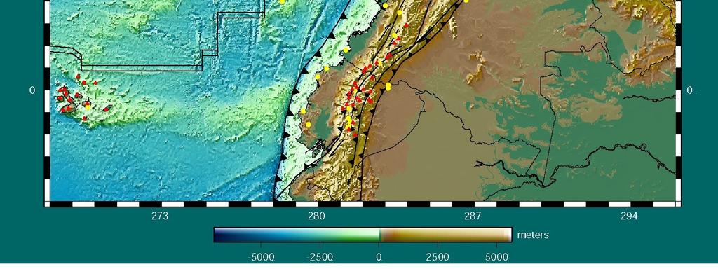
2 TECTONIC FRAME AND SEISMICITY López, 2009 RSNC, INGEOMINAS, 2010
3 GPS AND GEODYNAMICS IN COLOMBIA CASA Project Central And South America GPS Project Kellogg et al PRE-GEORED López, GEORED current RSNC, INGEOMINAS, 2010

4 Earthquakes, ( )

5 WHAT IS GeoRED? GEORED is a research and development project based on GNSS instrumentation proposed and initiated by the formerly Colombian Institute of Geology and Mining - INGEOMINAS in 2007, now Colombian Geological Survey, (Mora, 2006) This project takes into consideration political relevance, economic importance, social bearing, along with scientific, and technical pertinence, as an appropriate approach to cataloging, understanding and defining the geodynamics of northwestern South America in a multi-focused endeavor to study the crustal deformation in Colombia. GEORED is the pseudonym adopted for the project "Implementation of the National GNSS Network for geodynamics and the acronym for Geodesia: Red de Estudios de Deformación as the specific field application for the study and analysis of crustal deformation in Colombia. It is a research and development project financed by the Colombian Government and executed by the Colombian Geological Survey under the BPIN code of the National Planning Department

6 OBJECTIVES AND SCOPE The general purpose of the GEORED Project is to Improve the technical, scientific and operational capabilities in Colombia for analysis, interpretation and policy formulation regarding phenomena related to crustal deformation in Colombia, using GNSS satellite technology. GEORED is also designed to meet the following specific objectives: To implement an Active National GNSS Permanent Network for geodynamics with data transmission to an information-gathering center. To create GNSS mobile teams for campaign style data acquisition (passive network) - (active faults studies, post-seismic assistance, volcanic crisis assistance, mass movements monitoring, etc). To generate information about horizontal and vertical displacements as an essential input for the studies of crustal deformation. To establish a high precision geodetic reference frame for the multipurpose activities within CGS To provide information within CGS as well as to other government institutions toward the execution of research and development projects using GNSS data.

7 CRUSTAL SEGMENTATION OF THE NORTH ANDES WITHIN COLOMBIA Beginning in 2007, discussions within the GEORED group led to a master plan for the distribution of the base permanent GPS station array and specific areas of interest for campaign site construction. The use of previously identified active faults as preferred structures along which stresses are transferred through the deformational area led to the idea of segmentation of the North Andes within Colombia into 20 tectonic sub-blocks. These sub-blocks were determined taking into account some generalizations: A tectonic sub-block represents a homogeneous crustal entity limited by the main active faults, and it is thought to possess a characteristic pattern of internal deformation; At some fault segments, current kinematics, rupture dimensions and terminations remains unclear; moreover, detailed palaeoseismological and neotectonic studies are yet scarce. Due to this, it has been necessary to make some general assumptions about fault extension, geometry and sense of slip from geophysical interpretation, geological maps and reports; Some regions at plate interfaces are expected to be more heterogeneous and to have higher sub-block segmentation. But, owing to the fact that some of those places have not been studied in depth and are difficult to access, the polygons of the sub-blocks are only approximately outlined.

8 GEORED NETWORK IMPLEMENTATION GPS Permanent Stations - Status February 29, 2012

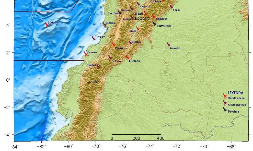
9 GNSS REFERENCE STATIONS FOR VOLCANIC DEFORMATION

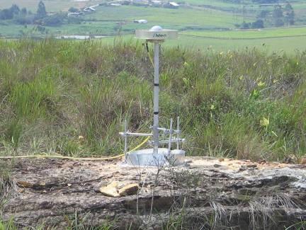
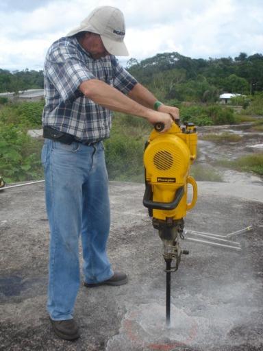
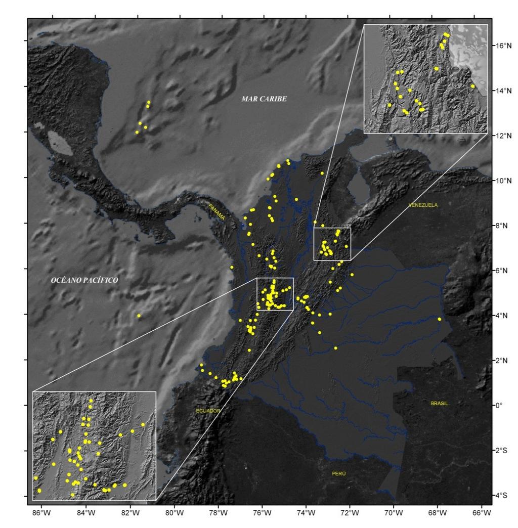
10 GEORED NETWORK IMPLEMENTATION GPS Field Stations - Status December 2011

11 GPS VELOCITIES ITRF2005 Mora et al, 2011


12 CHALLENGES The final objective of the GEORED project is to increase the knowledge of the current crustal deformation stage at Colombia. Specifically: To obtain geodetic rates of fault displacements, as well as to characterize the kinematics of active faults and their seismogenic potential; To generate crustal sub-block and regional deformation models to the Colombian territory, through the integration of geodetic, geological and geophysical data; To establish an operative and dense geodetic network with geodynamic purposes. In addition: To provide support to atmospheric, ionosphere, subsidence and mass movement studies
13 GPS TIME SERIES

14 GEORED NETWORK Current stations + next stations ACP Red Sismológica, Univ. Panamá FUNVISIS Escuela Politécnica de Quito Instituto Geofísico
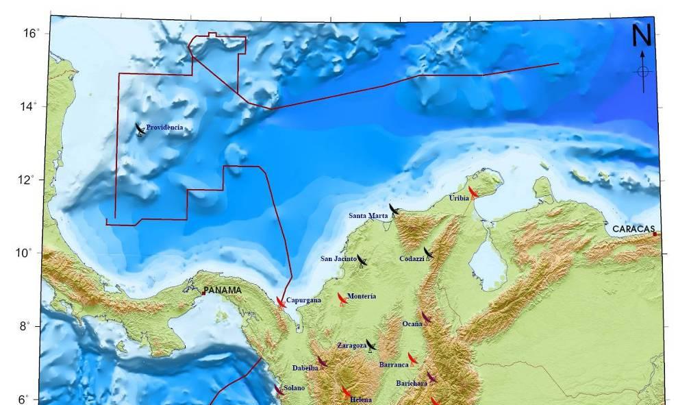
15 SEISMOLOGICAL NETWORK STRONG MOTION NETWORK

16 COCONET Project
Recent GNSS Developments and Reference Frame Issues in Turkey. Onur LENK and Bahadir AKTUĞ
 Recent GNSS Developments and Reference Frame Issues in Turkey Onur LENK and Bahadir AKTUĞ General Command of Mapping onur.lenk lenk@hgk.mil.tr 1/31 GPS STUDIES İN TURKEY date back to early 1990s geodynamics-oriented
SIRGAS: Basis for Geosciences, Geodata, and Navigation in Latin America
 SIRGAS: Basis for Geosciences, Geodata, and Navigation in Latin America Claudio Brunini President of SIRGAS Universidad Nacional de La Plata, Argentina María Virginia Mackern President of SIRGAS/WG-I:
GEODETIC NETWORK OF SAUDI ARABIA AND FIDUCIAL STATIONS. GFN OF Saudi Arabia in Based on ITRF2000 Datum
 STUDIES OF TECTONIC MOVEMENTS IN SAUDI ARABIA USING CORS M. Al Rajhi, Ali Al Omar, R. Yanar, F. Kartal, K. Eren, SUBJECT TO TALKS BACKGROUND GEODETIC NETWORK OF SAUDI ARABIA AND FIDUCIAL STATIONS GFN OF
The Continuously Operation Caribbean Observational Network: COCONet
 The Continuously Operation Caribbean Observational Network: COCONet Glen S. Mattioli University of Texas at Arlington Presenting for COCONet Executive Committee: M. Miller(1), E. Calais(2), C. Meertens(1),
CHILEAN PART OF SIRGAS REFERENCE FRAME, REALIZATION, ADOPTION, MAINTENANCE AND ACTUAL STATUS. Geodesy for Planet Earth IAG 2009, Buenos Aires
 CHILEAN PART OF SIRGAS REFERENCE FRAME, REALIZATION, ADOPTION, MAINTENANCE AND ACTUAL STATUS Geodesy for Planet Earth IAG 2009, Buenos Aires Ing. Héctor Parra hparra@igm.cl, IGM Chile Dr. Juan Báez jbaez@udec.cl,
GPS measurements of current crustal movements along the Gulf of Suez, Egypt.
 GPS measurements of current crustal movements along the Gulf of Suez, Egypt. Presented By Nadia Abo-Ali Assistant Researcher At National Research Institute of Astronomy and Geophysics (NRIAG), Helwan,
How GNSS CORS in Japan works for geodetic control and disaster mitigations
 ICG Working Group D Reference Frames, Timing and Applications How GNSS CORS in Japan works for geodetic control and disaster mitigations ICG11, Nov. 7-11, 2016, Sochi, Russia Hiromichi TSUJI Geodetic Observation
to: Interseismic strain accumulation and the earthquake potential on the southern San
 Supplementary material to: Interseismic strain accumulation and the earthquake potential on the southern San Andreas fault system by Yuri Fialko Methods The San Bernardino-Coachella Valley segment of the
ESTIMATES OF HORIZONTAL DISPLACEMENTS ASSOCIATED WITH THE 1999 TAIWAN EARTHQUAKE
 ESTIMATES OF HORIZONTAL DISPLACEMENTS ASSOCIATED WITH THE 1999 TAIWAN EARTHQUAKE C. C. Chang Department of Surveying and Mapping Engineering Chung Cheng Institute of Technology, Taiwan, ROC ABSTRACT A
The Impact of the 2010 Darfield (Canterbury) Earthquake on the Geodetic Infrastructure in New Zealand 1
 Earthquake on the Geodetic Infrastructure in New Zealand 1") The Impact of the 2010 Darfield (Canterbury) Earthquake on the Geodetic Infrastructure in New Zealand 1 Graeme BLICK, John BEAVAN, Chris CROOK, Nic DONNELLY Keywords: Darfield Earthquake, control, survey,
The Impact of the 2010 Darfield (Canterbury) Earthquake on the Geodetic Infrastructure in New Zealand 1 Graeme BLICK, John BEAVAN, Chris CROOK, Nic DONNELLY Keywords: Darfield Earthquake, control, survey,
Plate Boundary Observatory Working Group for the Central and Northern San Andreas Fault System PBO-WG-CNSA
 Plate Boundary Observatory Working Group for the Central and Northern San Andreas Fault System PBO-WG-CNSA Introduction Our proposal focuses on the San Andreas fault system in central and northern California.
The Structure of the Earth and Plate Tectonics
 The Structure of the Earth and Plate Tectonics Agree or Disagree? 1. The Earth if made up of 4 different layers. 2. The crust (where we live) can be made of either less dense continental crust or the more
GNSS measurements in Ulaanbaatar and its vicinity
 GNSS measurements in Ulaanbaatar and its vicinity Erdenezul Danzansan Institute of Astronomy and Geophysics MAS, Ulaanbaatar, Mongolia erdenezul@iag.ac.mn Andrei Miroshnichenko Institute of the Earth s
Incorporation of the Caribbean to the Geocentric Reference System for the Americas SIRGAS
 Incorporation of the Caribbean to the Geocentric Reference System for the Americas SIRGAS W. Martínez M. V. Mackern V. Cioce R. Rodino S.R. De Freitas UN-GGIM: Americas Third Session, October 5 2016, Mexico
The April 6 th 2009, L Aquila (Italy) earthquake: DInSAR analysis and seismic source model inversion
 earthquake: DInSAR analysis and seismic source model inversion") ESA ESRIN 30th November - 4th December 2009 Frascati, Italy The April 6 th 2009, L Aquila (Italy) earthquake: DInSAR analysis and seismic source model inversion Simone Atzori, Christian Bignami, Marco
ESA ESRIN 30th November - 4th December 2009 Frascati, Italy The April 6 th 2009, L Aquila (Italy) earthquake: DInSAR analysis and seismic source model inversion Simone Atzori, Christian Bignami, Marco
IS THE SUDETIC MARGINAL FAULT STILL ACTIVE? RESULTS OF THE GPS MONITORING
 Acta Geodyn. Geomater.Vol.1, No.3 (135), 35-39, 2004 IS THE SUDETIC MARGINAL FAULT STILL ACTIVE? RESULTS OF THE GPS MONITORING 1996-2002 Bernard KONTNY Department of Geodesy and Photogrammetry, Agricultural
Report for 15th PCGIAP Meeting at 18th UNRCC-AP Working Group 1 Regional Geodesy
 Report for 15th PCGIAP Meeting at 18th UNRCC-AP Working Group 1 Regional Geodesy Chairman Shigeru Matsuzaka, Japan - shigeru@gsi.go.jp Vice Chairman Prof. Pengfei Cheng, China - chengpf@casm.ac.cn John
Lab 9: Satellite Geodesy (35 points)
") Lab 9: Satellite Geodesy (35 points) Here you will work with GPS Time Series data to explore plate motion and deformation in California. This lab modifies an exercise found here: http://www.unavco.org:8080/cws/pbonucleus/draftresources/sanandreas/
Lab 9: Satellite Geodesy (35 points) Here you will work with GPS Time Series data to explore plate motion and deformation in California. This lab modifies an exercise found here: http://www.unavco.org:8080/cws/pbonucleus/draftresources/sanandreas/
The Global Geodetic Observing System (GGOS) of the International Association of Geodesy, IAG
 of the International Association of Geodesy, IAG") The Global Geodetic Observing System (GGOS) of the International Association of Geodesy, IAG Hans-Peter Plag (1), Markus Rothacher (2), Richard Gross (3), Srinivas Bettadpur (4) (1) Nevada Bureau of Mines
The Global Geodetic Observing System (GGOS) of the International Association of Geodesy, IAG Hans-Peter Plag (1), Markus Rothacher (2), Richard Gross (3), Srinivas Bettadpur (4) (1) Nevada Bureau of Mines
Actual Continuous Kinematic Model (ACKIM) of the Earth s Crust based on ITRF2014
 of the Earth s Crust based on ITRF2014") Actual Continuous Kinematic Model (ACKIM) of the Earth s Crust based on ITRF2014 Hermann Drewes Technische Universität München Joint Scientific Assembly of the International Association of Geodesy and
Actual Continuous Kinematic Model (ACKIM) of the Earth s Crust based on ITRF2014 Hermann Drewes Technische Universität München Joint Scientific Assembly of the International Association of Geodesy and
CORS Network and Datum Harmonisation in the Asia-Pacific Region. Richard Stanaway and Craig Roberts
 CORS Network and Datum Harmonisation in the Asia-Pacific Region Richard Stanaway and Craig Roberts School of Surveying and Spatial Information Systems University of New South Wales CORS Networks in the
Tectonic deformations in Greece and the operation of HEPOS network
 Tectonic deformations in Greece and the operation of HEPOS network M. Gianniou KTIMATOLOGIO S.A. (Hellenic Cadastre) Abstract Today, networks of permanent reference stations are broadly used for the realization
Electronic supplement for Forearc motion and deformation between El Salvador and Nicaragua: GPS, seismic, structural, and paleomagnetic observations
 DR2011053 Electronic supplement for Forearc motion and deformation between El Salvador and Nicaragua: GPS, seismic, structural, and paleomagnetic observations by D. Alvarado et al., Lithosphere, April,
Ground displacement in a fault zone in the presence of asperities
 BOLLETTINO DI GEOFISICA TEORICA ED APPLICATA VOL. 40, N. 2, pp. 95-110; JUNE 2000 Ground displacement in a fault zone in the presence of asperities S. SANTINI (1),A.PIOMBO (2) and M. DRAGONI (2) (1) Istituto
The Size and Duration of the Sumatra-Andaman Earthquake from Far-Field Static Offsets
 The Size and Duration of the Sumatra-Andaman Earthquake from Far-Field Static Offsets P. Banerjee, 1 F. F. Pollitz, 2 R. Bürgmann 3 * 1 Wadia Institute of Himalayan Geology, Dehra Dun, 248001, India. 2
Plate Tectonics 2. Ocean crust forms at mid-ocean ridges (with magnetic stripes )
") Plate Tectonics 2 Ocean crust forms at mid-ocean ridges (with magnetic stripes )! some more evidence for plate tectonics: (1)! magnetic stripes (conclusion) and (2) seeing it live with high-precision GPS!
Plate Tectonics 2 Ocean crust forms at mid-ocean ridges (with magnetic stripes )! some more evidence for plate tectonics: (1)! magnetic stripes (conclusion) and (2) seeing it live with high-precision GPS!
Lateral extrusion and tectonic escape in Ilan Plain of northeastern Taiwan
 Lateral extrusion and tectonic escape in Ilan Plain of northeastern Taiwan Angelier, J., Chang, T.Y., Hu, J.C., Chang, C.P., Siame, L., Lee, J.C., Deffontaines, B., Chu, H.T, Lu, C.Y., Does extrusion occur
A Glimpse at Geodetic Activities in Latin America
 UNIVERSIDADE DO ESTADO DO RIO DE JANEIRO CENTRO DE TECNOLOGIA E CIÊNCIAS FACULDADE DE ENGENHARIA DEPARTAMENTO DE ENGENHARIA CARTOGRÁFICA A Glimpse at Geodetic Activities in Latin America Prof. Luiz Paulo
The Structure of the Earth and Plate Tectonics
 The Structure of the Earth and Plate Tectonics Structure of the Earth The Earth is made up of 4 main layers: Inner Core Outer Core Mantle Crust Crust Mantle Outer core Inner core The Crust This is where
Plate Tectonics From VLBI And SLR Global Data Final Report (SuDoc NAS 1.26:191319) By Christopher G. A. Harrison READ ONLINE
 By Christopher G. A. Harrison READ ONLINE") Plate Tectonics From VLBI And SLR Global Data Final Report (SuDoc NAS 1.26:191319) By Christopher G. A. Harrison READ ONLINE If looking for a ebook Plate tectonics from VLBI and SLR global data final report
Plate Tectonics From VLBI And SLR Global Data Final Report (SuDoc NAS 1.26:191319) By Christopher G. A. Harrison READ ONLINE If looking for a ebook Plate tectonics from VLBI and SLR global data final report
FORMAT FOR TECHNICAL PAPERS
 TOWARDS A MODERNIZED GEODETIC DATUM FOR NEPAL: OPTIONS FOR DEVELOPING AN ACCURATE TERRESTRIAL REFERENCE FRAME FOLLOWING THE APRIL 25, 2015 MW7.8 GORKHA EARTHQUAKE Chris PEARSON 1, Niraj MANANDHA 2 ABSTRACT
Geodetic Observing Systems: tools in observing the Glacial Isostatic Adjustment. Markku Poutanen Finnish Geodetic Institute
 Geodetic Observing Systems: tools in observing the Glacial Isostatic Adjustment Markku Poutanen Finnish Geodetic Institute Glacial Isostatic Adjustment Land uplift is just one consequence of the physical
Working group. Study of the evolution of the seismic cycle of stress and strain to. Main areas of study. Research lines
 Study of the evolution of the seismic cycle of stress and strain to the El Salvador Fault Zone (ESFZ) Alejandra Staller Universidad Politécnica de Madrid Research group on Seismic Engineering Working group
Annual Report for Research Work in the fiscal year 2005
 JST Basic Research Programs C R E S T (Core Research for Evolutional Science and Technology) Annual Report for Research Work in the fiscal year 2005 Research Area : High Performance Computing for Multi-scale
TECTONIC MOVEMENTS MONITORING OF SUDETIC MARGINAL FAULT USING SHORT GPS BASELINES
 POSTER PAPER SESSION TECTONIC MOVEMENTS MONITORING OF SUDETIC MARGINAL FAULT USING SHORT GPS ASELINES ernard Kontny Department of Geodesy and Photogrammetry Agricultural University of Wroclaw, Poland Abstract
Military Geographic Institute
 New Chilean Reference Frame, 3 years after Maule Earthquake 90 YEARS SUPORTING THE NATIONAL DEVELOPMENT Major Julio Neira Gutierrez (MSc) Head of Geodetic Department & GDB Military Geographic Institute
Seismological laboratory in Agua Negra tunnel
 Instituto Geofísico Sismológico Volponi Universidad Nacional de San Juan Seismological laboratory in Agua Negra tunnel Buenos Aires, Abril 2011 Why a Seismological laboratory in Agua Negra tunnel? Earthquake
Yellowstone Hotspot Component of the Plate Boundary Observatory
 Yellowstone Hotspot Component of the Plate Boundary Observatory (Investigators: Smith, Thatcher, Meertens, Humphreys, Dzurisin, Oldow Co-Investigators: Christiansen, Doss, Schwartz, Machette, Wong, Olig,
Guidelines for Site-Specific Seismic Hazard Reports for Essential and Hazardous Facilities and Major and Special-Occupancy Structures in Oregon
 Guidelines for Site-Specific Seismic Hazard Reports for Essential and Hazardous Facilities and Major and Special-Occupancy Structures in Oregon By the Oregon Board of Geologist Examiners and the Oregon
A Unique Reference Frame: Basis of the Global Geodetic Observing System (GGOS) for Geodynamics and Global Change
 for Geodynamics and Global Change") SRTM (InSAR) A Unique Reference Frame: Basis of the Global Geodetic Observing System (GGOS) for Geodynamics and Global Change Hermann Drewes President IAG Commission 1 Reference Frames Deutsches Geodätisches
SRTM (InSAR) A Unique Reference Frame: Basis of the Global Geodetic Observing System (GGOS) for Geodynamics and Global Change Hermann Drewes President IAG Commission 1 Reference Frames Deutsches Geodätisches
Simulated and Observed Scaling in Earthquakes Kasey Schultz Physics 219B Final Project December 6, 2013
 Simulated and Observed Scaling in Earthquakes Kasey Schultz Physics 219B Final Project December 6, 2013 Abstract Earthquakes do not fit into the class of models we discussed in Physics 219B. Earthquakes
Athanassios Ganas,
 Current Status of the NOANET GNSS network 2006 2014 Athanassios Ganas, aganas@noa.grgr George Drakatos, Kostas Chousianitis Panagiotis Argyrakis, Marios Papanikolaou, Alexandra Moshou, Christina Tsimi,
Supplementary Material
 1 Supplementary Material 2 3 4 Interseismic, megathrust earthquakes and seismic swarms along the Chilean subduction zone (38-18 S) 5 6 7 8 9 11 12 13 14 1 GPS data set We combined in a single data set
The Theory of Continental Drift. Continental Drift Discovery
 The Theory of Continental Drift Continental Drift Discovery The World ALFRED WEGENER THEORY OF CONTINENTAL DRIFT Found evidence for PANGAEA and proposed the theory of continental drift. Continental Drift
Design of Safety Monitoring and Early Warning System for Buried Pipeline Crossing Fault
 5th International Conference on Civil Engineering and Transportation (ICCET 2015) Design of Safety Monitoring and Early Warning System for Buried Pipeline Crossing Fault Wu Liu1,a, Wanggang Hou1,b *, Wentao
Geodynamic Pattern of the West Bohemia during the October 2008 Earthquake Swarm
 10th Czech-Polish Workshop on RECENT GEODYNAMICS OF THE SUDETEN AND ADJACENT AREAS Szklarska Poręba, November 5-7, 2009 Geodynamic Pattern of the West Bohemia during the October 2008 Earthquake Swarm Vladimír
Determination of Current Velocity Field (Rate) of North Anatolian Fault in Izmit-Sapanca Segment
 of North Anatolian Fault in Izmit-Sapanca Segment") Determination of Current Velocity Field (Rate) of North Anatolian Fault in Izmit-Sapanca Segment Cetin MEKIK, Bulent TURGUT, Haluk OZENER, Turkish Republic INTRODUCTION Turkey is geologically the part
Determination of Current Velocity Field (Rate) of North Anatolian Fault in Izmit-Sapanca Segment Cetin MEKIK, Bulent TURGUT, Haluk OZENER, Turkish Republic INTRODUCTION Turkey is geologically the part
Next Generation Australian Datum. Permanent Committee on Geodesy, ICSM
 Next Generation Australian Datum Permanent Committee on Geodesy, ICSM 2 Presentation: Next Generation Australian Datum Trends in the geospatial sector The Geocentric Datum of Australia 1994 (GDA94) Progress
Sendai Earthquake NE Japan March 11, Some explanatory slides Bob Stern, Dave Scholl, others updated March
 Sendai Earthquake NE Japan March 11, 2011 Some explanatory slides Bob Stern, Dave Scholl, others updated March 14 2011 Earth has 11 large plates and many more smaller ones. Plates are 100-200 km thick
Case Study of Japan: Crustal deformation monitoring with GNSS and InSAR
 Technical Seminar Reference Frame in Practice, Case Study of Japan: Crustal deformation monitoring with GNSS and InSAR Basara Miyahara miyahara-b96ip@milt.go.jp Geospatial Information Authority of Japan
Empirical Green s Function Analysis of the Wells, Nevada, Earthquake Source
 Nevada Bureau of Mines and Geology Special Publication 36 Empirical Green s Function Analysis of the Wells, Nevada, Earthquake Source by Mendoza, C. 1 and Hartzell S. 2 1 Centro de Geociencias, Universidad
Data Repository of Paper: The role of subducted sediments in plate interface dynamics as constrained by Andean forearc (paleo)topography
topography") Data Repository of Paper: The role of subducted sediments in plate interface dynamics as constrained by Andean forearc (paleo)topography Nicolás J. Cosentino 1*, Felipe Aron 2,3, Jorge G. F. Crempien 2,3,
Data Repository of Paper: The role of subducted sediments in plate interface dynamics as constrained by Andean forearc (paleo)topography Nicolás J. Cosentino 1*, Felipe Aron 2,3, Jorge G. F. Crempien 2,3,
Overview of the Seismic Source Characterization for the Palo Verde Nuclear Generating Station
 Overview of the Seismic Source Characterization for the Palo Verde Nuclear Generating Station Scott Lindvall SSC TI Team Lead Palo Verde SSC SSHAC Level 3 Project Tuesday, March 19, 2013 1 Questions from
NCC roles in successful disaster response I.R.IRAN
 The Second UN-GGIM-AP Plenary Meeting NCC roles in successful disaster response I.R.IRAN Teheran Iran 28-30 October 2013 Ali Javidaneh Technical Deputy of National Cartographic Center (NCC) Outline Types
Christine M. Puskas. Objective: A geophysical position where a background in geophysical modeling, data processing, and GPS studies can be applied.
 Christine M. Puskas 777 E South Temple 9C Salt Lake City, UT 84102 www.uusatrg.utah.edu/people/christine (801) 581-7856 Office (801) 521-4107 Home c.puskas@utah.edu Education Ph.D. in Geophysics, University
Geodesy (InSAR, GPS, Gravity) and Big Earthquakes
 and Big Earthquakes") Geodesy (InSAR, GPS, Gravity) and Big Earthquakes Mathew Pritchard Teh-Ru A. Song Yuri Fialko Luis Rivera Mark Simons UJNR Earthquake Research Panel, Morioka, Japan - Nov 6, 2002 Goals Accurate and high
Geodesy (InSAR, GPS, Gravity) and Big Earthquakes Mathew Pritchard Teh-Ru A. Song Yuri Fialko Luis Rivera Mark Simons UJNR Earthquake Research Panel, Morioka, Japan - Nov 6, 2002 Goals Accurate and high
GRAVIMETRIC MAP OF CHILE. Services Mining and Engineering Geophysics Instituto Geográfico Militar
 GRAVIMETRIC MAP OF CHILE Araneda M., Rivas L., Avendaño M, Sottolichio G., Rubio W. Services Mining and Engineering Geophysics segmi@netexpress.cl) Instituto Geográfico Militar (lrivas@igm.cl) Abstract
Study on the feature of surface rupture zone of the west of Kunlunshan pass earthquake ( M S 811) with high spatial resolution satellite images
 with high spatial resolution satellite images") 48 2 2005 3 CHINESE JOURNAL OF GEOPHYSICS Vol. 48, No. 2 Mar., 2005,,. M S 811.,2005,48 (2) :321 326 Shan X J, Li J H, Ma C. Study on the feature of surface rupture zone of the West of Kunlunshan Pass
48 2 2005 3 CHINESE JOURNAL OF GEOPHYSICS Vol. 48, No. 2 Mar., 2005,,. M S 811.,2005,48 (2) :321 326 Shan X J, Li J H, Ma C. Study on the feature of surface rupture zone of the West of Kunlunshan Pass
Separating Tectonic, Magmatic, Hydrological, and Landslide Signals in GPS Measurements near Lake Tahoe, Nevada-California
 Separating Tectonic, Magmatic, Hydrological, and Landslide Signals in GPS Measurements near Lake Tahoe, Nevada-California Geoffrey Blewitt, Corné Kreemer, William C. Hammond, & Hans-Peter Plag NV Geodetic
Study megathrust creep to understand megathrust earthquakes
 1 Study megathrust creep to understand megathrust earthquakes Kelin Wang Pacific Geoscience Centre, Geological Survey of Canada, kelin.wang@canada.ca Introduction Once upon a time, there was a belief that
Densification of the GGOS infrastructure in Poland in the framework of EPOS-PL
 EPOS European Plate Observing System Densification of the GGOS infrastructure in Poland in the framework of EPOS-PL K. Sośnica 1, J. Bosy 1, J. Kapłon 1, W. Rohm 1, T. Hadaś 1, J. Sierny 1, I. Kudłacik
GEO-VIII November Geohazard Supersites and Natural Laboratories Progress Report. Document 9
 GEO-VIII 16-17 November 2011 Geohazard Supersites and Natural Laboratories Progress Report Document 9 This document is submitted to GEO-VIII for information. Geohazard Supersites and Natural Laboratories
THE JANUARY 25TH, 1999, EARTHQUAKE IN THE COFFEE GROWING REGION OF COLOMBIA
 0 THE JANUARY TH,, EARTHQUAKE IN THE COFFEE GROWING REGION OF COLOMBIA Luis E GARCIA And Omar D CARDONA SUMMARY At : PM local time (: GMT) of January,, a. m b magnitude, ±0 km depth earthquake occurred
The problem (1/2) GPS velocity fields in plate boundary zones are very smooth. What does this smoothness hide?
 GPS velocity fields in plate boundary zones are very smooth. What does this smoothness hide?") Block models The problem (1/2) GPS velocity fields in plate boundary zones are very smooth Figure from Tom Herring, MIT What does this smoothness hide? Continuous deformation? Rigid block motions, with
Block models The problem (1/2) GPS velocity fields in plate boundary zones are very smooth Figure from Tom Herring, MIT What does this smoothness hide? Continuous deformation? Rigid block motions, with
NTUA, Faculty of Rural and Surveying Engineering, Dionysos Satellite Observatory, Higher Geodesy Laboratory NOA, Institute of Geodynamics 1
 NOA, Institute of Geodynamics 1 Crustal Deformation from GPS measurements at the Ionian Sea : Preliminary Results Anastasiou 1 D., Paradissis 1 D., Ganas 2 A., Marinou 1 A., Papazissi 1 K., Drakatos 2
Case study of Japan: Reference Frames in Practice
 Case study of Japan: Reference Frames in Practice Basara Miyahara and Koji Matsuo Sponsors: 1 Outline Introduction - Geodetic reference frame of Japan - GEONET : continuous GNSS observation system Geometric
Estimation of tectonic velocities using GPS Precise Point Positioning: The case of Hellenic RTK network HEPOS
 Estimation of tectonic velocities using GPS Precise Point Positioning: The case of Hellenic RTK network HEPOS M. Gianniou, I. Stavropoulou National Cadastre and Mapping Agency S.A. Mesogion Ave. 288, 15562
El proyecto Sistema de Observación Geodésico Global [Global Geodetic Observing System (GGOS)] de la Asociación Internacional de Geodesia (IAG)
![El proyecto Sistema de Observación Geodésico Global [Global Geodetic Observing System (GGOS)] de la Asociación Internacional de Geodesia (IAG)](/thumbs/79/79010389.jpg "El proyecto Sistema de Observación Geodésico Global [Global Geodetic Observing System (GGOS)] de la Asociación Internacional de Geodesia (IAG)") El proyecto Sistema de Observación Geodésico Global [Global Geodetic Observing System (GGOS)] de la Asociación Internacional de Geodesia (IAG) Hermann Drewes Deutsches Geodätisches Forschungsinstitut (DGFI)
El proyecto Sistema de Observación Geodésico Global [Global Geodetic Observing System (GGOS)] de la Asociación Internacional de Geodesia (IAG) Hermann Drewes Deutsches Geodätisches Forschungsinstitut (DGFI)
The Earthquake of Padang, Sumatra of 30 September 2009 scientific information and update
 The Earthquake of Padang, Sumatra of 30 September 2009 scientific information and update 01-October-2009 Christophe Vigny Directeur de recherches at CNRS Laboratoire de Géologie Geoscience Dept. Of ENS,
COMPOSITION and PHYSICAL PROPERTIES GENERAL SUBJECTS. GEODESY and GRAVITY
 COMPOSITION and PHYSICAL PROPERTIES Composition and structure of the continental crust Composition and structure of the core Composition and structure of the mantle Composition and structure of the oceanic
Low-Latency Earthquake Displacement Fields for Tsunami Early Warning and Rapid Response Support
 Low-Latency Earthquake Displacement Fields for Tsunami Early Warning and Rapid Response Support Hans-Peter Plag, Geoffrey Blewitt Nevada Bureau of Mines and Geology and Seismological Laboratory University
Algerian Space Agency Center of Space Techniques
 Algerian Space Agency Center of Space Techniques Investigation of deformations in North of Algeria with GPS data and kinematic model Radia MIR, Salem ahlouche, Saïd Touam Space Geodesy Division Center
GEM Faulted Earth. A Global Active Fault and Fault Source Database
 GEM Faulted Earth A Global Active Fault and Fault Source Database Marco Pagani on behalf of GEM Faulted Earth Kelvin Berryman, Carlos Costa, Kerry Sieh Nicola Litchfield, Annemarie Christophersen THIS
EXAMINATION ON CONSECUTIVE RUPTURING OF TWO CLOSE FAULTS BY DYNAMIC SIMULATION
 EXAMINATION ON CONSECUTIVE RUPTURING OF TWO CLOSE FAULTS BY DYNAMIC SIMULATION M. Muto 1, K. Dan 1, H. Torita 1, Y. Ohashi 1, and Y. Kase 2 1 Ohsaki Research Institute, Inc., Tokyo, Japan 2 National Institute
TEGAM s Connection to the EarthScope Project
 TEGAM s Connection to the EarthScope Project Introduction The EarthScope Project is an undertaking funded by the National Science Foundation in partnership with the United States Geological Survey and
Geodesy. orientation. shape. gravity field
 Geodesy noun Science of measuring the shape, orientation and gravity field of the Earth and how it changes over time. shape orientation gravity field Positioning has always been important Downstream applications
The Application of GNSS to Monitoring Fault Deformation
 The Application of GNSS to Monitoring Fault Deformation Shengtao FENG, Wanju BO, Jianfeng SU, Haitao ZHOU, Xuesong DU, Wenni WAN, Tianhai LIU, China Key words: GNSS, fault deformation, baseline, crustal
Reference frames and positioning
 The APREF Project: an Improved Geodetic Infrastructure for Asia and the Pacific (4861) John Dawson (Australia), Graeme Blick (New Zealand), Manoj Deo, Guorong Hu and Gary Johnston (Australia) Reference
GPS Strain & Earthquakes Unit 4: GPS strain analysis examples Student exercise
 GPS Strain & Earthquakes Unit 4: GPS strain analysis examples Student exercise Example 1: Olympic Peninsula Name: Please complete the following worksheet to estimate, calculate, and interpret the strain
The Japanese University Joint Seismic Observations at the Niigaka-Kobe Tectonic Zone
 Bull. Earthq. Res. Inst. Univ. Tokyo Vol. 2*,**/ pp. +-- +.1 * The Japanese University Joint Seismic Observations at the Niigaka-Kobe Tectonic Zone The Japanese University Group of the Joint Seismic Observations
Haiti: Earthquake on January 12, 2010
 Geophysical Hazards and Plate Boundary Processes In Central America, Mexico and the Caribbean Haiti: Earthquake on January 12, 2010 Situation, achievements and perspective. Hotel La Condesa, Costa Rica
Earthquakes. Earthquake Magnitudes 10/1/2013. Environmental Geology Chapter 8 Earthquakes and Related Phenomena
 Environmental Geology Chapter 8 Earthquakes and Related Phenomena Fall 2013 Northridge 1994 Kobe 1995 Mexico City 1985 China 2008 Earthquakes Earthquake Magnitudes Earthquake Magnitudes Richter Magnitude
Widespread Ground Motion Distribution Caused by Rupture Directivity during the 2015 Gorkha, Nepal Earthquake
 Widespread Ground Motion Distribution Caused by Rupture Directivity during the 2015 Gorkha, Nepal Earthquake Kazuki Koketsu 1, Hiroe Miyake 2, Srinagesh Davuluri 3 and Soma Nath Sapkota 4 1. Corresponding
Basics of the modelling of the ground deformations produced by an earthquake. EO Summer School 2014 Frascati August 13 Pierre Briole
 Basics of the modelling of the ground deformations produced by an earthquake EO Summer School 2014 Frascati August 13 Pierre Briole Content Earthquakes and faults Examples of SAR interferograms of earthquakes
Geochemistry, Geophysics, Geosystems. Supporting Information for
 1 2 3 4 5 6 7 8 Geochemistry, Geophysics, Geosystems Supporting Information for Volcano Deformation Survey over the Northern and Central Andes with ALOS InSAR Time Series Anieri M. Morales Rivera 1, Falk
Analysis Strategies And Software For Geodetic VLBI
 Analysis Strategies And Software For Geodetic VLBI Rüdiger Haas Presentation at the 7th EVN Symposium, Toledo, 2004 Outline: Observing stategies and observables Data analysis strategies Data analysis software
Characterizing Earthquake Rupture Models for the Prediction of Strong Ground Motion
 Characterizing Earthquake Rupture Models for the Prediction of Strong Ground Motion Paul Somerville URS Corporation, 566 El Dorado Street, Pasadena, CA, 91101, USA Summary The uncertainty in estimates
Syllabus and Course Description Geophysical Geodesy Fall 2013 GPH 411/611
 Syllabus and Course Description Geophysical Geodesy Fall 2013 GPH 411/611 Course Location: LME 422 Course Time: Tuesday & Thursday 12:00-1:15 Units: 3 Instructor Name: Bill Hammond Office Location: SEM
PLATE DEFORMATION - 2
 H4.SMR/1775-24 "8th Workshop on Three-Dimensional Modelling of Seismic Waves Generation, Propagation and their Inversion" 25 September - 7 October 2006 PLATE DEFORMATION - 2 Roberto Sabadini Dipartimento
The International Terrestrial Reference System and ETRS89: Part I : General concepts
 The International Terrestrial Reference System and ETRS89: Part I : General concepts Zuheir ALTAMIMI Laboratoire de Recherche en Géodésie Institut national de l information géographique et forestière (IGN),
Advantages of GNSS in Monitoring Crustal Deformation for Detection of Precursors to Strong Earthquakes
 Positioning, 2013, 4, 11-19 http://dx.doi.org/10.4236/pos.2013.41003 Published Online February 2013 (http://www.scirp.org/journal/pos) 11 Advantages of GNSS in Monitoring Crustal Deformation for Detection
Summary so far. Geological structures Earthquakes and their mechanisms Continuous versus block-like behavior Link with dynamics?
 Summary so far Geodetic measurements velocities velocity gradient tensor (spatial derivatives of velocity) Velocity gradient tensor = strain rate (sym.) + rotation rate (antisym.) Strain rate tensor can
Update on the International Terrestrial Reference Frame (ITRF) : ITRF2014. Zuheir Altamimi
 : ITRF2014. Zuheir Altamimi") Update on the International Terrestrial Reference Frame (ITRF) : ITRF2014 Zuheir Altamimi Head of the IERS ITRF Product Center IAG Vice President IGN, France E-mail: zuheir.altamimi@ign.fr Key Points Introduction:
Update on the International Terrestrial Reference Frame (ITRF) : ITRF2014 Zuheir Altamimi Head of the IERS ITRF Product Center IAG Vice President IGN, France E-mail: zuheir.altamimi@ign.fr Key Points Introduction:
SM2.1/GD2.7/NH5.8/TS8.4, Large Earthquake and Tsunami Activity (co-organized), 13:30 17:00, Room B3
, 13:30 17:00, Room B3") SM Seismology Orals and PICOs MO1, 08:30 10:00 MO2, 10:30 12:00 MOL, 12:15 13:15 MO3, 13:30 15:00 MO4, 15:30 17:00 TU1, 08:30 10:00 Monday, 08 April SM1.2/AS4.13, Research and Development in Nuclear Explosion
SM Seismology Orals and PICOs MO1, 08:30 10:00 MO2, 10:30 12:00 MOL, 12:15 13:15 MO3, 13:30 15:00 MO4, 15:30 17:00 TU1, 08:30 10:00 Monday, 08 April SM1.2/AS4.13, Research and Development in Nuclear Explosion
Downtown Anchorage Seismic Risk Assessment & Land Use Regulations to Mitigate Seismic Risk
 Prepared for: The Municipality of Anchorage Planning Department and the Geotechnical Advisory Commission Downtown Anchorage Seismic Risk Assessment & Land Use Regulations to Mitigate Seismic Risk Prepared
Global Positioning System(GPS) Global Positioning System(GPS) is a new surveying technique applying space technology designed by the United States
 Global Positioning System(GPS) is a new surveying technique applying space technology designed by the United States") IV/317 Crustal deformations in the Japanese islands observed with the nationwide continuous GPS observation system Takashi TADA (Crustal Dynamics Department, Geographical Survey Institute, Tsukuba, Ibaraki,
IV/317 Crustal deformations in the Japanese islands observed with the nationwide continuous GPS observation system Takashi TADA (Crustal Dynamics Department, Geographical Survey Institute, Tsukuba, Ibaraki,
Realizing a geodetic reference frame using GNSS in the presence of crustal deformations: The case of Greece
 Realizing a geodetic reference frame using GNSS in the presence of crustal deformations: The case of Greece M. Gianniou National Cadastre and Mapping Agency S.A. Outline 1. Introduction 2. Deformation
What scientists know and do not know about the big one at Cascadia
 What scientists know and do not know about the big one at Cascadia Kelin Wang Pacific Geoscience Centre, Geological Survey of Canada Natural Resources Canada The Cascadia Subduction Zone M 7.3, 1946 Rupture
CSRC Director s Report
 CSRC Director s Report C S R C Yehuda Bock Scripps Orbit and Permanent Array Center (SOPAC) California Spatial Reference Center (CSRC) Scripps Institution of Oceanography La Jolla CSRC Coordinating Council
COUNTRY REPORT THE SEVENTEENTH PERMANENT COMMITTEE ON GIS INFRASTRUCTURE FOR ASIA AND THE PACIFIC (PCGIAP) MEETING JULY 21 22, 2011,
 MEETING JULY 21 22, 2011,") COUNTRY REPORT INDONESIA ACTIVITIES IN 2010 THE SEVENTEENTH PERMANENT COMMITTEE ON GIS INFRASTRUCTURE FOR ASIA AND THE PACIFIC (PCGIAP) MEETING JULY 21 22, 2011, CHINGGIS KHAAN HOTEL, ULAANBAATAR CITY,
COUNTRY REPORT INDONESIA ACTIVITIES IN 2010 THE SEVENTEENTH PERMANENT COMMITTEE ON GIS INFRASTRUCTURE FOR ASIA AND THE PACIFIC (PCGIAP) MEETING JULY 21 22, 2011, CHINGGIS KHAAN HOTEL, ULAANBAATAR CITY,