El proyecto Sistema de Observación Geodésico Global [Global Geodetic Observing System (GGOS)] de la Asociación Internacional de Geodesia (IAG)
|
|
|
- Meredith Richard
- 6 years ago
- Views:
Transcription
1 El proyecto Sistema de Observación Geodésico Global [Global Geodetic Observing System (GGOS)] de la Asociación Internacional de Geodesia (IAG) Hermann Drewes Deutsches Geodätisches Forschungsinstitut (DGFI) München, Germany PAIGH Representative of the International Union of Geodesy and Geophysics (IUGG) IUGG Reunión IPGH, Caracas, Venezuela, 17 de noviembre de 2005
2 The International Association of Geodesy The International Association of Geodesy (IAG) is a scientific organization within the International Union of Geodesy and Geophysics (IUGG) under the umbrella of the International Council for Science (ICSU). The mission of IAG is the advancement of geodesy as an Earth science. It is structured into four Commissions and twelve Services for fundamental and applied research and the generation of products in support of science and society. The Global Geodetic Observing System (GGOS) serves as a flagship of IAG to coordinate the geodetic research work and to represent geodesy in other sciences and in society. It was installed in 2003 and is in full function since GG S
3 The International Association of Geodesy Commissions 1 Reference Frames Pres.: H. Drewes 2 Gravity Field Pres.: C. Jekeli Inter-Commission-Committees 3 Geodynamics Pres.: V. Dehant 4 Applications Pres.: C. Rizos Theory, Pres.: P. Xu Planetary Geodesy, Pres.: D. Smith Services IERS Chopo Ma ILRS W. Gurtner IGS J. Dow Association Project IVS W. Schlüter IDS G. Tavernier IGFS R. Forsberg BGI J.-P. Barriot IGeS F. Sanso ICET B. Ducarme PSMSL P.L. Woodworth BIPM E.F. Arias Global Geodetic Observing System (GGOS), President: M. Rothacher IBS A. Korth


4 4 GGOS integrates different techniques, models and approaches in order to achieve better consistency and long-term reliability as science & infrastructure basis in Earth sciences. The Vision of GGOS Geometric and gravimetric techniques Geometry Orientation Sea Surface Gravity field Identical constants, conventions, models,... Geodynamics, Cadastre, Political Global Change Borders, Land Management, Astronautics Engineering,, Navigation

... and the combination of both, e.g.")
5 The Mission of GGOS (1) GGOS shall ensure the consistency between all geodetic standards, observations, models, reference frames, and all the products: Geometric reference frames (ITRF2000) Gravimetric reference frames (GGM)... and the combination of both, e.g., the globally unified height systems. 5 GG S
6 The Mission of GGOS (2) GGOS shall improve visibility of geodesy in science and society. GGOS shall be established as an official partner in the United Nations Integrated Global Observing Strategy (IGOS). GGOS has become, via IAG, a participating organization in the inter-governmental Group on Earth Observations (GEO). GGOS participated in preparing the 10 year implementation plan of a Global Earth Observation System of Systems (GEOSS). GEO and GEOSS have got their Secretariat in 2005 in Geneve, Switzerland. 6 GG S
; water circulation in oceans, ice covers, atmosphere, solid Earth (satellite")
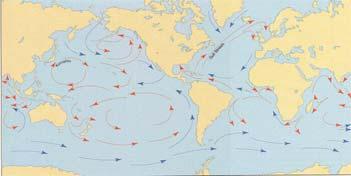
7 The Objectives of GGOS GGOS shall have the central theme Global deformation and mass exchange processes in the System Earth. 7 Geodesy is capable of observing deformation and mass processes: deformation of the solid Earth (geometry and kinematics); water circulation in oceans, ice covers, atmosphere, solid Earth (satellite altimetry, gravity missions, atmosphere sounding); mass exchange between the atmosphere, the hydrosphere and the biosphere (variations of Earth rotation and gravity field). GG S
 (1) Plate")
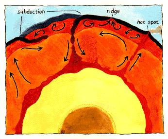
8 Effects on the Solid Earth (Geosphere) (1) Plate kinematics
 (Drewes/Heidbach,")
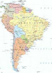
9 Effects on the Solid Earth (Geosphere) (2) Crustal deformation in South America (SIRGAS) (Drewes/Heidbach, 2005) GG S
 (3) Co-seismic")

10 Effects on the Solid Earth (Geosphere) (3) Co-seismic displacements Two Earthquakes in El Salvador 2000/01 Earthquake Arequipa


11 Effects on the Solid Earth (Geosphere) (4) Co-seismic displacements

12 Effects on the Oceans (1) Sea Surface Topography from Satellite Altimetry 12

13 Effects on the Oceans (2) Sea Level Changes from Satellite Altimetry

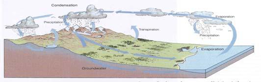
14 Combination of Geodetic Observations of Solid Earth and Oceans: Height Systems Height systems are defined by the mean sea level at an arbitrarily selected tide gauge over an arbitrarily selected time period. The sea level changes geographically and with time. Therefore, the height systems referring to different tide gauges have different levels. 14 Only the combination of levelling, gravity and sea level allows a unified height system. GG S
15 Requirements for Height Systems Physical height systems are a basic geodetic product for many applications, e.g., navigation, engineering, water supply,... The global unification of height systems of all countries is a major objective of geodesy in general and of GGOS in particular. The unification requires geometric and gravimetric information: sea level at tide gauges, spirit levelling, and gravimetry. The adjustment of all available data has to be coordinated in an international cooperation. The collaboration of all countries is solicited and appreciated for the benefit of science and society. 15 GG S
16 Conclusion GGOS has the mission to guarantee the reliability of geodetic products by ensuring the consistency of standards, models, parameters, and reference systems. The horizontal component is well done in the Americas by SIRGAS. The vertical component is quite a bit behind the requirements of practical applications: ± 50 cm for air navigation (worldwide), ± 10 cm for large area water supply (national), ± 1 cm for engineering (regional, trans-national). The collaboration of all American countries for unification of the height systems is solicited. 16 Thank you! GG S
The Global Geodetic Observing System (GGOS) of the International Association of Geodesy (IAG)
 of the International Association of Geodesy (IAG)") The Global Geodetic Observing System (GGOS) of the International Association of Geodesy (IAG) Hermann Drewes Representative of the International Union of Geodesy and Geophysics (IUGG) to the Cartographic
The Global Geodetic Observing System (GGOS) of the International Association of Geodesy (IAG) Hermann Drewes Representative of the International Union of Geodesy and Geophysics (IUGG) to the Cartographic
A Unique Reference Frame: Basis of the Global Geodetic Observing System (GGOS) for Geodynamics and Global Change
 for Geodynamics and Global Change") SRTM (InSAR) A Unique Reference Frame: Basis of the Global Geodetic Observing System (GGOS) for Geodynamics and Global Change Hermann Drewes President IAG Commission 1 Reference Frames Deutsches Geodätisches
SRTM (InSAR) A Unique Reference Frame: Basis of the Global Geodetic Observing System (GGOS) for Geodynamics and Global Change Hermann Drewes President IAG Commission 1 Reference Frames Deutsches Geodätisches
The Global Geodetic Observing System (GGOS) of the International Association of Geodesy, IAG
 of the International Association of Geodesy, IAG") The Global Geodetic Observing System (GGOS) of the International Association of Geodesy, IAG Hans-Peter Plag (1), Markus Rothacher (2), Richard Gross (3), Srinivas Bettadpur (4) (1) Nevada Bureau of Mines
The Global Geodetic Observing System (GGOS) of the International Association of Geodesy, IAG Hans-Peter Plag (1), Markus Rothacher (2), Richard Gross (3), Srinivas Bettadpur (4) (1) Nevada Bureau of Mines
SIRGAS: Basis for Geosciences, Geodata, and Navigation in Latin America
 SIRGAS: Basis for Geosciences, Geodata, and Navigation in Latin America Claudio Brunini President of SIRGAS Universidad Nacional de La Plata, Argentina María Virginia Mackern President of SIRGAS/WG-I:
Strategy for the Realization of the International Height Reference System (IHRS)
") Deutsches Geodätisches Forschungsinstitut (DGFI-TUM) Technische Universität München Strategy for the Realization of the International Height Reference System (IHRS) Laura Sánchez 1, Johannes Ihde 2, Roland
Deutsches Geodätisches Forschungsinstitut (DGFI-TUM) Technische Universität München Strategy for the Realization of the International Height Reference System (IHRS) Laura Sánchez 1, Johannes Ihde 2, Roland
REGIONAL REFERENCE FRAMES: THE IAG PERSPECTIVE
 REGIONAL REFERENCE FRAMES: THE IAG PERSPECTIVE João Agria Torres SPUIAGG IAG Sub-commission 1.3: Regional Reference Frames jatorres@iol.pt 1. About the IAG CONTENT 2. Objectives and organization of SC
Global & National Geodesy, GNSS Surveying & CORS Infrastructure
 Global & National Geodesy, GNSS Surveying & CORS Infrastructure Chris Rizos School of Surveying & Spatial Information Systems University of New South Wales, Sydney, Australia President-elect, International
Structure of the International Association of Geodesy For the period
 Structure of the International Association of Geodesy For the period 2003-2007 Bureau President Vice President Secretary General Excecutive committee. Gerhard Beutler (Switzerland) Michael Sideris (Canada)
Global vertical datum unification based on the combination of the fixed gravimetric and the scalar free geodetic boundary value problems
 Global vertical datum unification based on the combination of the fixed gravimetric and the scalar free geodetic boundary value problems Laura Sánchez contribution to the IAG-IC.: Vertical Reference Frames
Fundamental Station Wettzell - geodetic observatory -
 Fundamental Station Wettzell - geodetic observatory - Wolfgang Schlüter Bundesamt für Kartographie und Geodäsie, Fundamental Station Wettzell Germany Radiometer Workshop, Wettzell, 10.10.06 Evolvement
International Union of Geodesy and Geophysics. Resolutions
 International Union of Geodesy and Geophysics Resolutions ADOPTED BY THE COUNCIL AT THE XXVI GENERAL ASSEMBLY PRAGUE, CZECH REPUBLIC (22 JUNE 2 JULY 2015) 0 Page Resolution 1: Role of Ocean in Climate
Establishment of a Global Absolute Gravity Network
 Establishment of a Global Absolute Gravity Network H. Wilmes 1), H. Wziontek 1), R. Falk 1), J. Ihde 1), S. Bonvalot 2), R. Forsberg 3), S. Kenyon 4), L. Vitushkin 5) 1) Federal Agency for Cartography
Frequent epoch reference frames instead of instant station positions and constant velocities
 Deutsches Geodätisches Forschungsinstitut Technische Universität München (DGFI-TUM) Frequent epoch reference frames instead of instant station positions and constant velocities Hermann Drewes Deutsches
GGOS, ECGN and NGOS: Global and regional geodetic observing systems. Markku Poutanen Finish Geodetic Institute
 GGOS, ECGN and NGOS: Global and regional geodetic observing systems Markku Poutanen Finish Geodetic Institute Contents GGOS, ECGN, NGOS Why? How? Future? (geodesy) GGOS Structure GGOS Structure European
GGOS The Global Geodetic Observing System of the International Association of Geodesy (IAG)
") GGOS The Global Geodetic Observing System of the International Association of Geodesy (IAG) Hansjörg KUTTERER, Germany Key words: Geodetic Reference Frames, Global Geodetic Observing System, International
GGOS The Global Geodetic Observing System of the International Association of Geodesy (IAG) Hansjörg KUTTERER, Germany Key words: Geodetic Reference Frames, Global Geodetic Observing System, International
The Interactions between IGS and GGOS
 The Interactions between IGS and GGOS Markus Rothacher Institute of Geodesy and Photogrammetry (IGP) ETH Zurich, Switzerland 2012 IGS Workshop July 23-27, 2012, Olsztyn, Poland Overview GGOS Vision, Mission
GG S Global Geodetic Observing System (GGOS): Status and Future. Markus Rothacher, Ruth Neilan, Hans-Peter Plag
: Status and Future. Markus Rothacher, Ruth Neilan, Hans-Peter Plag") 2020 Global Geodetic Observing System (GGOS): Status and Future Markus Rothacher, Ruth Neilan, Hans-Peter Plag GeoForschungsZentrum Potsdam (GFZ) Jet Propulsion Laboratory (JPL) University of Nevada, Reno
2020 Global Geodetic Observing System (GGOS): Status and Future Markus Rothacher, Ruth Neilan, Hans-Peter Plag GeoForschungsZentrum Potsdam (GFZ) Jet Propulsion Laboratory (JPL) University of Nevada, Reno
The Kinematic Reference Frame for ITRF
 The Kinematic Reference Frame for ITRF Hermann Drewes and Barbara Meisel Deutsches Geodätisches Forschungsinstitut Munich, Germany IERS Workshop, Potsdam, 10.10.2005 Motivation and Objectives The kinematic
Geodetic Observing Systems: tools in observing the Glacial Isostatic Adjustment. Markku Poutanen Finnish Geodetic Institute
 Geodetic Observing Systems: tools in observing the Glacial Isostatic Adjustment Markku Poutanen Finnish Geodetic Institute Glacial Isostatic Adjustment Land uplift is just one consequence of the physical
GGOS Bureau for Standards and Conventions
 GGOS D. Angermann (1), T. Gruber (2), J. Bouman (1), M. Gerstl (1), R. Heinkelmann (1), U. Hugentobler (2), L. Sánchez (1), P. Steigenberger (2) (1) Deutsches Geodätisches Forschungsinstitut (DGFI), München
GGOS. Global Geodetic Observing System. Carey Noll NASA GSFC (on behalf of GGOS) WDS Forum September 11, 2016
 WDS Forum September 11, 2016") https://ntrs.nasa.gov/search.jsp?r=20160011397 2018-12-07T18:04:29+00:00Z GGOS Global Geodetic Observing System Carey Noll NASA GSFC (on behalf of GGOS) WDS Forum September 11, 2016 Global Geodetic Observing
https://ntrs.nasa.gov/search.jsp?r=20160011397 2018-12-07T18:04:29+00:00Z GGOS Global Geodetic Observing System Carey Noll NASA GSFC (on behalf of GGOS) WDS Forum September 11, 2016 Global Geodetic Observing
Incorporation of the Caribbean to the Geocentric Reference System for the Americas SIRGAS
 Incorporation of the Caribbean to the Geocentric Reference System for the Americas SIRGAS W. Martínez M. V. Mackern V. Cioce R. Rodino S.R. De Freitas UN-GGIM: Americas Third Session, October 5 2016, Mexico
GG S. Internal Vision of GGOS. Markus Rothacher. GFZ Potsdam
 Internal Vision of GGOS Markus Rothacher GFZ Potsdam GGOS Retreat DGFI in Munich February 15-16, 2006 Contents Motivation Four Levels of Products of the IAG Services: First Level: Raw Data Collection Second
GGOS The Global Geodetic Observing System of the International Association of Geodesy
 GGOS The Global Geodetic Observing System of the International Association of Geodesy Presented at the FIG Working Week 2017, May 29 - June 2, 2017 in Helsinki, Finland Hansjörg Kutterer BKG, Germany Content
Lecture 2 Measurement Systems. GEOS 655 Tectonic Geodesy
 Lecture 2 Measurement Systems GEOS 655 Tectonic Geodesy VLBI and SLR VLBI Very Long Baseline Interferometry SLR Satellite Laser Ranging Very Long Baseline Interferometry VLBI Geometric Delay δg S Baseline
Update on the International Terrestrial Reference Frame (ITRF) : ITRF2014. Zuheir Altamimi
 : ITRF2014. Zuheir Altamimi") Update on the International Terrestrial Reference Frame (ITRF) : ITRF2014 Zuheir Altamimi Head of the IERS ITRF Product Center IAG Vice President IGN, France E-mail: zuheir.altamimi@ign.fr Key Points Introduction:
Update on the International Terrestrial Reference Frame (ITRF) : ITRF2014 Zuheir Altamimi Head of the IERS ITRF Product Center IAG Vice President IGN, France E-mail: zuheir.altamimi@ign.fr Key Points Introduction:
Dependences in the pillar Earth s gravity field of
 Reports on Geodesy, vol. 92, no. 1, 2012 Dependences in the pillar Earth s gravity field of GGOS - description using UML notation Małgorzata Paśnicka 1, Karolina Szafranek 2, Agnieszka Zwirowicz Rutkowska
From Global to National Geodetic Reference Frames: how are they connected and why are they needed?
 From Global to National Geodetic Reference Frames: how are they connected and why are they needed? Zuheir ALTAMIMI Institut National de l Information Géographique et Forestière, France Vice-President,
Status. EUREF TWG Meeting November 8 9, 2004, Praha
 ECGN was initiated by IAG Sub-Commission for Europe EUREF (SC1.3a) and IAG Sub-Commission for Europe of the International Gravity and Geoid Commission (IGGC) with relationship to Joint Research Centre
Consideration of a Global Vertical Reference System (GVRS) in the IERS Conventions
 in the IERS Conventions") Consideration of a Global Vertical Reference System (GVRS) in the IERS Conventions Johannes Ihde Federal Agency for Cartography and Geodesy (BKG) Chair of IAG ICP1.2 (2003-2007) Vertical Reference Frames
Consideration of a Global Vertical Reference System (GVRS) in the IERS Conventions Johannes Ihde Federal Agency for Cartography and Geodesy (BKG) Chair of IAG ICP1.2 (2003-2007) Vertical Reference Frames
Towards a Rigorous Combination of Space Geodetic Techniques
 Towards a Rigorous Combination of Space Geodetic Techniques Markus Rothacher Forschungseinrichtung Satellitengeodäsie, TU Munich, Germany Abstract: The with all its different components and products, ranging
Report for 15th PCGIAP Meeting at 18th UNRCC-AP Working Group 1 Regional Geodesy
 Report for 15th PCGIAP Meeting at 18th UNRCC-AP Working Group 1 Regional Geodesy Chairman Shigeru Matsuzaka, Japan - shigeru@gsi.go.jp Vice Chairman Prof. Pengfei Cheng, China - chengpf@casm.ac.cn John
A new best estimate for the conventional value W 0
 - Final Report of the G on Vertical Datum tandardization - L. ánchez Deutsches Geodätisches Forschungsinstitut, Technische Universität München DGFI-TUM, Germany R. Čunderlí, K. Miula, Z. Minarechová Department
GGOS INFORMATION MODELS: ANALYSIS OF INTERRELATIONS BETWEEN OBSERVATION TECHNIQUES AND THE EARTH GRAVITY FIELD
 GGOS INFORMATION MODELS: ANALYSIS OF INTERRELATIONS BETWEEN OBSERVATION TECHNIQUES AND THE EARTH GRAVITY FIELD Wojciech Pachelski 1) Małgorzata Paśnicka-Pawłowska 2) Karolina Szafranek 3) Agnieszka Zwirowicz
Role and importance of the International Terrestrial Reference Frame for sustainable development
 Role and importance of the International Terrestrial Reference Frame for sustainable development This report is provided for the benefit of participants of the UNRCC-PCGIAP Informal Geodetic Consultation,
A Glimpse at Geodetic Activities in Latin America
 UNIVERSIDADE DO ESTADO DO RIO DE JANEIRO CENTRO DE TECNOLOGIA E CIÊNCIAS FACULDADE DE ENGENHARIA DEPARTAMENTO DE ENGENHARIA CARTOGRÁFICA A Glimpse at Geodetic Activities in Latin America Prof. Luiz Paulo
Linking the Global Geodetic Observing System (GGOS) (IGOS-P) through the Theme Earth System Dynamics. with the Integrated Global Observing Strategy
 (IGOS-P) through the Theme Earth System Dynamics. with the Integrated Global Observing Strategy") Linking the Global Geodetic Observing System (GGOS) to the Integrated Global Observing Strategy Partnership (IGOS-P) through the Theme Earth System Dynamics H.-P. Plag, Nevada Bureau of Mines and Geology
Linking the Global Geodetic Observing System (GGOS) to the Integrated Global Observing Strategy Partnership (IGOS-P) through the Theme Earth System Dynamics H.-P. Plag, Nevada Bureau of Mines and Geology
Geocentric Reference System for the Americas 4th Session UN-GGIM Americas April 2017, Santiago, Chile
 Geocentric Reference System for the Americas 4th Session UN-GGIM Americas April 2017, Santiago, Chile María Virginia Mackern Vicepresidente SIRGAS Consejo Nacional de Investigaciones Científicas y Técnicas,
International Gravity Field Service (IGFS)
") IAG-Services: International Gravity Field Service (IGFS) 477 International Gravity Field Service (IGFS) http://www.gravityfield.org Chairman: Renè Forsberg (Denmark, 2011-2013) - Riccardo Barzaghi (Italy,
IAG-Services: International Gravity Field Service (IGFS) 477 International Gravity Field Service (IGFS) http://www.gravityfield.org Chairman: Renè Forsberg (Denmark, 2011-2013) - Riccardo Barzaghi (Italy,
3.6 ITRS Combination Centres
 3 Reports of IERS components 3.6.1 Deutsches Geodätisches Forschungsinstitut (DGFI) In 2010, the focus of the ITRS Combination Centre at DGFI was on the finalization of the ITRS realization DTRF2008, internal
New satellite mission for improving the Terrestrial Reference Frame: means and impacts
 Fourth Swarm science meeting and geodetic missions workshop ESA, 20-24 March 2017, Banff, Alberta, Canada New satellite mission for improving the Terrestrial Reference Frame: means and impacts Richard
Preface. About this book. Background
 Foreword The Global Geodetic Observing System (GGOS) has been established by the International Association of Geodesy (IAG) in order to integrate the three fundamental areas of geodesy, so as to monitor
Contribution of non-tidal oceanic mass variations to Earth rotation determined from space geodesy and ocean data
 Earth FOR584 rotation Earth and rotation global and dynamic global processes dynamic processes Contribution of non-tidal oceanic mass variations to Earth rotation determined from space geodesy and ocean
A Strategic Plan for Geodesy in Sweden. Mikael Lilje Lars E. Engberg Geodesy Department Lantmäteriet Sweden
 A Strategic Plan for Geodesy in Sweden Mikael Lilje Lars E. Engberg Geodesy Department Lantmäteriet Sweden Our vision is to be able to meet Swedish society s needs for a homogeneous, sustainable geodetic
IGFS Structure Director : Rene Forsberg
 IGFS Structure Director : Rene Forsberg International Gravimetric Bureau (BGI) Director S. Bonvalot International Geoid Service (IGeS) Director R. Barzaghi International Center for Global Earth Models
Reference Systems Realization for the Territory of Bulgaria - Status and Perspectives
 Conference and plenary meeting of the Permanent Committee on Cadastre in the European Union 13-15 March 2018, Sofia Reference Systems Realization for the Territory of Bulgaria - Status and Perspectives
PAN AMERICAN INSTITUTE OF GEOGRAPHY AND HISTORY Specialized Organization of the OAS
 PAN AMERICAN INSTITUTE OF GEOGRAPHY AND HISTORY Specialized Organization of the OAS 10 th UNRCC Americas United Nations, New York, 20 August 2013 PAIGH, SIRGAS, PC-IDEA and GeoSUR 2013-2015 Joint Action
Journal of Geodesy. The Geodesist s Handbook Volume 77 Number April International Association of Geodesy
 Volume 77 Number 10-11 April 2004 Journal of Geodesy 77 10-11 The Geodesist s Handbook 2004 International Association of Geodesy International Union of Geodesy and Geophysics Central Bureau Department
Global Geodetic Reference Frame GGRF & Implications for GNSS
 Global Geodetic Reference Frame GGRF & Implications for GNSS On behalf of Gary Johnston Chair GIAC, Ruth Neilan Vice Chair, Global Geodetic Observing System ICG-9 Prague, 10 November 2014 UN GGRF Working
Call for space geodetic solutions corrected for non-tidal atmospheric loading (NT-ATML) at the observation level
 at the observation level") Call for space geodetic solutions corrected for non-tidal atmospheric loading (NT-ATML) at the observation level Xavier Collilieux, Tonie van Dam, Zuheir Altamimi Outline: Context Why correcting for non-tidal
Call for space geodetic solutions corrected for non-tidal atmospheric loading (NT-ATML) at the observation level Xavier Collilieux, Tonie van Dam, Zuheir Altamimi Outline: Context Why correcting for non-tidal
COUNTRY REPORT THE SEVENTEENTH PERMANENT COMMITTEE ON GIS INFRASTRUCTURE FOR ASIA AND THE PACIFIC (PCGIAP) MEETING JULY 21 22, 2011,
 MEETING JULY 21 22, 2011,") COUNTRY REPORT INDONESIA ACTIVITIES IN 2010 THE SEVENTEENTH PERMANENT COMMITTEE ON GIS INFRASTRUCTURE FOR ASIA AND THE PACIFIC (PCGIAP) MEETING JULY 21 22, 2011, CHINGGIS KHAAN HOTEL, ULAANBAATAR CITY,
COUNTRY REPORT INDONESIA ACTIVITIES IN 2010 THE SEVENTEENTH PERMANENT COMMITTEE ON GIS INFRASTRUCTURE FOR ASIA AND THE PACIFIC (PCGIAP) MEETING JULY 21 22, 2011, CHINGGIS KHAAN HOTEL, ULAANBAATAR CITY,
Reference Frame in Practice Workshop 1A
 Reference Frame in Practice Workshop 1A Status of Geodetic Infrastructure in the Pacific Region Case Studies Rob Sarib - FIG Commission 5 Vice Chair of Administration Welcome! Bula! Who are the International
Splinter meeting at GGHS2016 Wednesday, Sept. 21, 2016 Laura Sánchez
 Working Group on the Strategy for the Realization of the International Height Reference System (IHRS) Splinter meeting at GGHS2016 Wednesday, Sept. 21, 2016 Laura Sánchez -Brainstorming and definition
Roadmap Towards Future Satellite Gravity Missions in Support of Monitoring of Mass Redistribution, Global Change, and Natural Hazards
 Roadmap Towards Future Satellite Gravity Missions in Support of Monitoring of Mass Redistribution, Global Change, and Natural Hazards STRATEGIC TARGET A multi-decade, continuous series of space-based observations
Geospatial Information Management in the Americas: Lessons for the Post-2015 development agenda
 Geospatial Information Management in the Americas: Lessons for the Post-2015 development agenda Rolando Ocampo President, UN-GGIM: Americas October 2014 The integration of statistical and geographical
IGS Services & Other Initiatives. Chris Rizos UNSW, Australia President IAG
 IGS Services & Other Initiatives Chris Rizos UNSW, Australia President IAG The IAG & FIG promote the adoption of the ITRF by all nations & users as the basis for fundamental national or regional datums,
Torsten Mayer-Gürr Institute of Geodesy, NAWI Graz Technische Universität Graz
 GGOS and Reference Systems Introduction 2015-10-12 Torsten Mayer-Gürr Institute of Geodesy, NAWI Graz Technische Universität Graz Torsten Mayer-Gürr 1 Course and exam Lecture Monday 14:00 16:00, A111 (ST01044)
Contributions of Geodesy to Oceanography
 Contributions of Geodesy to Oceanography B. Tapley and J. Ries Center for Space Research, The University of Texas at Austin Dynamic Planet 2005 Cairns, Australia August 22-26, 2005 August 22-26, 2005 Dynam
The Pan American Institute of Geography and History (PAIGH) North America National Mapping Meeting May 10, 2018
 North America National Mapping Meeting May 10, 2018") The Pan American Institute of Geography and History (PAIGH) North America National Mapping Meeting May 10, 2018 Pan American Institute of Geography and History (PAIGH) PAIGH was founded in 1928 and their
The Pan American Institute of Geography and History (PAIGH) North America National Mapping Meeting May 10, 2018 Pan American Institute of Geography and History (PAIGH) PAIGH was founded in 1928 and their
Working Group 1. Geodetic Reference Frame. Activity Report. for. The UN-GGIM-AP Plenary Meeting
 Regional Committee of United Nations Global Geospatial Information Management for Asia and the Pacific (UN-GGIM-AP) Established by a United Nations Resolution Working Group 1 Geodetic Reference Frame Activity
Military Geographic Institute
 New Chilean Reference Frame, 3 years after Maule Earthquake 90 YEARS SUPORTING THE NATIONAL DEVELOPMENT Major Julio Neira Gutierrez (MSc) Head of Geodetic Department & GDB Military Geographic Institute
Physical Dynamics of the Coastal Zone in the Mediterranean on Annual to Decadal Scales
 Physical Dynamics of the Coastal Zone in the Mediterranean on Annual to Decadal Scales Hans-Peter Plag Nevada Bureau of Mines and Geology and Seismological Laboratory University of Nevada, Reno, Nevada,
Assessment of the International Terrestrial Reference System 2014 realizations by Precise Orbit Determination of SLR Satellites
 Deutsches Geodätisches Forschungsinstitut (DGFI-TUM) Technische Universität München Assessment of the International Terrestrial Reference System 2014 realizations by Precise Orbit Determination of SLR
GEORED Project: GNSS Geodesy Network for Geodynamics Research in Colombia, South America. Héctor Mora-Páez
 GEORED Project: GNSS Geodesy Network for Geodynamics Research in Colombia, South America. Héctor Mora-Páez Colombian Geological Survey UNAVCO SCIENCE MEETING Feb 27 March 1, 2012 Boulder, CO, TECTONIC
Turkey s National SDI Implementation
 Onur PAŞAOĞULLARI Head of Department Turkey s National SDI Implementation Presentation Plan NSDI Background General Directorate of Geographic Information Systems NSDI Project INSPIRE Directive Urban Information
Geodesy. orientation. shape. gravity field
 Geodesy noun Science of measuring the shape, orientation and gravity field of the Earth and how it changes over time. shape orientation gravity field Positioning has always been important Downstream applications
What does EUREF considers as a realisation of EVRS?
 1 (1) DRAFT PM 2010-05-24 previous versions: 2010-03-08 2010-02-15 What does EUREF considers as a realisation of EVRS? Contents Contents...1 Purpose of document...1 Short review on activities towards a
Report of PCGIAP to the 18 th United Nations Regional Cartographic Conference for Asia and the Pacific (UNRCC-AP) for the period
 for the period") Permanent Committee on GIS Infrastructure for Asia and the Pacific (PCGIAP) Established in 1995 by a United Nations Resolution Report of PCGIAP to the 18 th United Nations Regional Cartographic Conference
Permanent Committee on GIS Infrastructure for Asia and the Pacific (PCGIAP) Established in 1995 by a United Nations Resolution Report of PCGIAP to the 18 th United Nations Regional Cartographic Conference
Evaluation of the Earth Gravity Model EGM2008 in Algeria
 Evaluation of the Earth Gravity Model EGM2008 in Algeria BENAHMED DAHO S. A. National Centre of Space Techniques, Geodetic Laboratory - BP 13 Arzew - 31200 - Algeria. E-mail: d_benahmed@hotmaii.com /Fax:
Reference frames and positioning
 The APREF Project: an Improved Geodetic Infrastructure for Asia and the Pacific (4861) John Dawson (Australia), Graeme Blick (New Zealand), Manoj Deo, Guorong Hu and Gary Johnston (Australia) Reference
The GOCE Geoid in Support to Sea Level Analysis
 The GOCE Geoid in Support to Sea Level Analysis The geoid is a very useful quantity for oceanographers Thomas Gruber Astronomical & Physical Geodesy (IAPG) Technische Universität München 1. Characteristics
Development Of Common Frameworks And Methodologies *
 HIGH LEVEL FORUM ON GLOBAL GEOSPATIAL MANAGEMENT INFORMATION WORKING PAPER No. 9 First Forum Seoul, Republic of Korea, 24-26 October 2011 Development Of Common Frameworks And Methodologies * * Submitted
Specification of the Baltic Sea Chart Datum 2000 (BSCD2000)
") Specification of the Baltic Sea Chart Datum 2000 (BSCD2000) DRAFT by Jonas Ågren, Gunter Liebsch and Jyrki Mononen Version 3a, 2018-02-06 1. Definition The Baltic Sea Chart Datum 2000 (BSCD2000) is a geodetic
Specification of the Baltic Sea Chart Datum 2000 (BSCD2000) DRAFT by Jonas Ågren, Gunter Liebsch and Jyrki Mononen Version 3a, 2018-02-06 1. Definition The Baltic Sea Chart Datum 2000 (BSCD2000) is a geodetic
The European Surveying Plot A surveying map of land property: A proposal and it s perspectives
 The European Surveying Plot A surveying map of land property: A proposal and it s perspectives Nikolaos KALAMAKIS, Greece Key words: INSPIRE, Interoperability, National Geographic Organizations, technical
CHILEAN PART OF SIRGAS REFERENCE FRAME, REALIZATION, ADOPTION, MAINTENANCE AND ACTUAL STATUS. Geodesy for Planet Earth IAG 2009, Buenos Aires
 CHILEAN PART OF SIRGAS REFERENCE FRAME, REALIZATION, ADOPTION, MAINTENANCE AND ACTUAL STATUS Geodesy for Planet Earth IAG 2009, Buenos Aires Ing. Héctor Parra hparra@igm.cl, IGM Chile Dr. Juan Báez jbaez@udec.cl,
Positioning in the Pacific Islands
 Positioning in the Pacific Islands Andrick Lal United Nations/Nepal Workshop on the Applications of Global Navigation Satellite Systems Kathmandu - Nepal 15 th December 2016 Presentation Outline Introduction
STANDARD COVER PAGE FOR ESA STUDY CONTRACT REPORTS ESA STUDY CONTRACT REPORT - SPECIMEN. Subject: Height System Unification with GOCE
 STANDARD COVER PAGE FOR ESA STUDY CONTRACT REPORTS ESA STUDY CONTRACT REPORT - SPECIMEN ESA Contract No: 4000102848/11/NL/EL Subject: Height System Unification with GOCE Contractor: Technische Universität
Geodetic applications of GNSS in the Black Sea region
 BALGEOS II - Balkan countries integration into GGOS Second workshop, 27-29 January, 2010 Vienna - AUSTRIA Geodetic applications of GNSS in the Black Sea region Lyubka Pashova CENTRAL LABORATORY OF GEODESY
FIG Asia Pacific Capacity Development Network
 FIG Asia Pacific Capacity Development Network Report to the 41th General Assembly FIG Congress 2018, Istanbul - Turkey Rob Sarib Chair FIG Asia Pacific Capacity Development Network (AP CDN) Story of the
CORS Network and Datum Harmonisation in the Asia-Pacific Region. Richard Stanaway and Craig Roberts
 CORS Network and Datum Harmonisation in the Asia-Pacific Region Richard Stanaway and Craig Roberts School of Surveying and Spatial Information Systems University of New South Wales CORS Networks in the
GSDI Global Spatial Data Infrastructure. Convergences between Geo Spatial Communities: key decision for decision making
 GSDI Global Spatial Data Infrastructure Convergences between Geo Spatial Communities: key decision for decision making April 14 th 2010 Bas Kok GSDI Past-President Director of International Affairs, Dutch
Warkworth geodetic station as a potential GGOS core site in New Zealand
 "Launching the Next-Generation IVS Network Session 2: Correlators, Stations and Operations Centers. 7th IVS General Meeting March 5, 2012 Madrid, Spain Warkworth geodetic station as a potential GGOS core
Geodetic Observations and Global Reference Frame Contributions to Understanding Sea - Level Rise and Variability
 9 Geodetic Observations and Global Reference Frame Contributions to Understanding Sea - Level Rise and Variability Geoff Blewitt, Zuheir Altamimi, James Davis, Richard Gross, Chung-Yen Kuo, Frank G. Lemoine,
Understanding Earth Rotation Part 2: Physical Foundations and Interpretation
 Understanding Earth Rotation Part 2: Physical Foundations and Interpretation Prof. Dr. Florian Seitz Technische Universität München (TUM) Deutsches Geodätisches Forschungsinstitut (DGFI) Munich, Germany
Summary of the 2012 Global Geophysical Fluid Center Workshop
 Summary of the 2012 Global Geophysical Fluid Center Workshop T. van Dam (Uni. Lux), J. Ray (NGS/NOAA), X. Collilieux (IGN) Introduction Review the history of the GGFC Discuss the 2012 Workshop Review recommendations
Cooperation is the key, FIG can facilitate
 Cooperation is the key, FIG can facilitate Mikael Lilje Vice President 2017-2020 Head, Geodetic infrastructure, Swedish mapping, cadastral and land registration authority Presented at the GIS/RS Conference
Modernization of National Geodetic Datum in China *
 UNITED NATIONS E/CONF.102/IP.16 ECONOMIC AND SOCIAL COUNCIL Nineteenth United Nations Regional Cartographic Conference for Asia and the Pacific Bangkok, 29 October 1 November 2012 Item 6(b) of the provisional
WELCOME SPEECH OF THE CIT PRESIDENT
 COSTA RICA FROM NOVEMBER 12 TO 15, 2007 WELCOME SPEECH OF THE CIT PRESIDENT Cordial Greetings, good morning. Bach. Fernando Zumbado Minister of Housing Eng. Stig Enemack President of the FIG Dear partners
3.3 Analysis Coordinator
 1. Introduction 2. Analysis of ITRF2014 post-seismic parameterization In this report we outline the activities of the Analysis Coordinator during 2015. The main activities were analysis of the ITRF2014
Originally published as:
 Originally published as: Seitz M., Steigenberger P., Artz T. (2xx) Consistent adjustment of combined terrestrial and celestial reference frames, Earth on the Edge: Science for a Sustainable Planet, IAG
Actual Continuous Kinematic Model (ACKIM) of the Earth s Crust based on ITRF2014
 of the Earth s Crust based on ITRF2014") Actual Continuous Kinematic Model (ACKIM) of the Earth s Crust based on ITRF2014 Hermann Drewes Technische Universität München Joint Scientific Assembly of the International Association of Geodesy and
Actual Continuous Kinematic Model (ACKIM) of the Earth s Crust based on ITRF2014 Hermann Drewes Technische Universität München Joint Scientific Assembly of the International Association of Geodesy and
SDI Development in Georgia. Mari Khardziani Head of International Relations Unit National Agency of Public Registry
 SDI Development in Georgia Mari Khardziani Head of International Relations Unit National Agency of Public Registry Kehl, Germany September 5, 2017 2 National Agency of Public Registry Legal Entity of Public
D DAVID PUBLISHING. Towards a New Geoid Model of Tanzania Using Precise Gravity Data. 1. Introduction. Selassie David Mayunga
 Journal of Environmental Science and Engineering A 5 (2016) 267-276 doi:10.17265/2162-5298/2016.05.005 D DAVID PUBLISHING Towards a New Geoid Model of Tanzania Using Precise Gravity Data Selassie David
Report of Uruguay The National Spatial Data Infrastructure
 Report of Uruguay The National Spatial Data Infrastructure Prepared for High-Level Forum on Global Geospatial Information Management (GGIM) and Inaugural Session of the UN Committee of Experts on GGIM
2018/1 The integration of statistical and geospatial information. The Regional Committee of UN-GGIM: Americas:
 The following are the conclusions and recommendations of the Regional Committee of the United Nations on Global Geospatial Information Management for the Americas, during its Fifth Session, Thursday 8
5 Coordinate Reference Systems
 5 Coordinate Reference Systems 5.1 Overview The INSPIRE theme Coordinate reference systems (CRS) provides a harmonised specification for uniquely referencing spatial information, either using three-dimensional,
The GGOS as the backbone for global observing and local monitoring: A user driven perspective
 Journal of Geodynamics 40 (2005) 479 486 The GGOS as the backbone for global observing and local monitoring: A user driven perspective H.-P. Plag Geodetic Institute, Norwegian Mapping Authority, Honefoss,
Earth system. space. planets. atmosphere. ice sheets. ocean. biosphere, technosphere. solid Earth. gravitation on. orbit, spin, tides
 third lecture Three Lectures: One ESA explorer mission GOCE: earth gravity from space Two Signal Processing on a sphere Three Gravity and earth sciences Earth system space sun moon planets gravitation
The African Geoid Project and Its Relevance to the Unification of African Vertical Reference Frames
 The African Geoid Project and Its Relevance to the Unification of African Vertical Reference Frames Charles L MERRY, South Africa Key words: geoid, vertical datum, leveling. SUMMARY The African Geoid Project
Detailed Geoid Model for Africa Final Report
 Detailed Geoid Model for Africa Final Report Hussein A. Abd-Elmotaal Minia University, Faculty of Engineering Civil Engineering Department Egypt abdelmotaal@lycos.com 1. Over View This report summaries