Fundamental Station Wettzell - geodetic observatory -
|
|
|
- Shannon Cain
- 6 years ago
- Views:
Transcription

1 Fundamental Station Wettzell - geodetic observatory - Wolfgang Schlüter Bundesamt für Kartographie und Geodäsie, Fundamental Station Wettzell Germany Radiometer Workshop, Wettzell,
2 Evolvement of Geodetic Space Techniques Progress in accuracy through space techniques 1960 Satellite Triangulation (first global network) ~10 m 1970 Satellite Laser Ranging 1. Gen. ~1 m TRANSIT (Doppler) ~ m 1980 Satellite Laser Ranging 3. Gen. ~3 cm Very Long Baseline Interferometry (VLBI) ~3 cm 1990 SLR/VLBI/GPS progress ~1 cm 2000 Combination of Space Techniques ~3 mm Progress is based on technology developments of the last decades Laser technology Electronic signal processing IT developments (VLBI: data recording, ) T&F (atomic clocks, frequency generator, time transfer) Etc... High Accuracy opens new fields for research and applications

3 Changing Earth - Interactions Mantle Convections Plate Motion Volcanism Sea level Rise Ice melting Warming up Tides (Moon, Sun, Planets) Ocean tides Earth tides Ocean Mass transport Loading Atmosphere/Wind Mass transport Loading Groundwater changes Variations in Positions, Gravity Field, Earth Rotation
4 Continuous observations required Monitoring the variations Improve the models (predictions) Understanding of geophysical phenomena Maintenance of global reference frames for positioning in Space and on Earth Quasar, Stars, Planets, Moon...) Space Crafts, Satellites,... ) Geodesy Geo-Information Navigation.. Fundamental for Research in all Geosciences and related disciplines IAG-PP: GGOS (Global Geodetic Observing System) global reference frame, 10-9 precise consistent in geometrical and physical parameters! consistent for decades!


5 Global Reference Frames ICRF: International Celestial Reference Frame Quasar Positions ITRF: International Terrestrial Reference Frame Position Coordinates Velocity Vector EOP: Earth Orientation Parameter Precession/Nutation Polar Motion UT1 - UTC Earth Rotation combines ICRF and ITRF GGOS extension to Gravity Field etc.
")
")
")
6 Geodetic Space Techniques VLBI VLBI (Very Long Baseline Interferometry) SLR/LLR Satellite/Lunar Laser Ranging GNSS (GPS, GLONASS, future: Galileo) DORIS (Doppler Orbitography and Radio Positioning Integrated by Satellite) SLR/LLR GNSS/GPS DORIS
7 International Cooperation: IAG-, IAU- Services The maintenance of global reference frames is a very complex and a global task, which can only be solved on the international level. In the last years, international services were established by the individual techniques, in the frame of the International Association of Geodesy (IAG) or International Astronomical Union (IAU), in order to coordinate the observations, the data flow, the analysis and the development of technology. The services are the Geometric Services International GNSS Service (IGS), International Laser Ranging Service (ILRS), International VLBI Service for Geodesy and Astrometry (IVS) International DORIS Service (IDS) and the Combination of the products by International Earth Rotation and Reference Frame Service (IERS). IAG-PP: GGOS (Global Geodetic Observing System) needs also Gravimetric Services International Gravimetric Bureau (BGI) International Center for Earth Tides (ICET) Permanent Service for Mean Sea Level (PSMSL) International Gravity Field Service (IGFS)

8 RMS of Geodetic Space Techniques (From a global TRF solution derived by DGFI, Munich)

9 VLBI for Geodesy and Astrometry Observable τ Simultaneous observations of Quasars Recording of radio signals transmitted from quasars (satellites) S/X-band VLBI2010: broadband 2-18GHz IVS observing Program R1... R4.. R&D, CONTxx, INT etc. Data transfer to Correlator Courier e-vlbi Correlation process provides τ Products: Baselines Station coordinates and velocities Earth Orientation Parameter (EOP) Quasar positions, variations tropospheric parameter physical parameters etc.

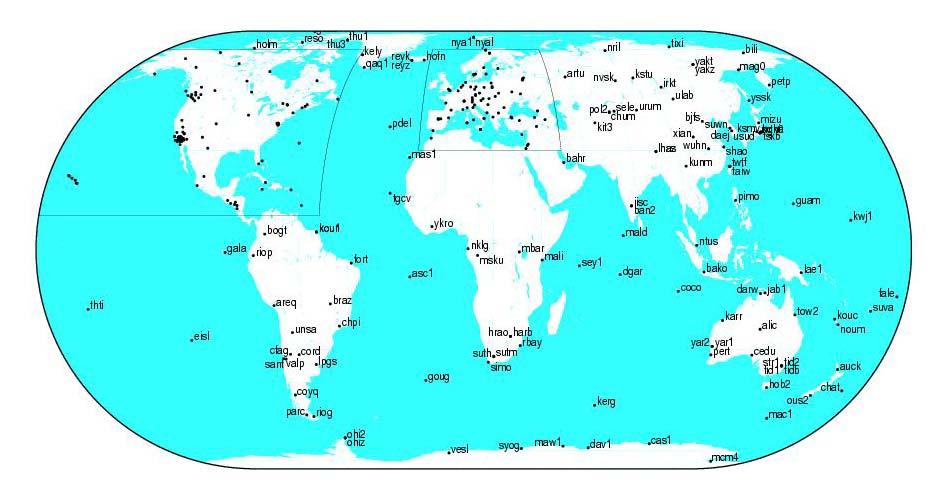
10 Map of the IVS Components
11 SLR/LLR Observable: propagation time t of a Laser pulse between the transmission from the SLR/LLR system, reflection at the target (satellite, Lunar) and receiving of the returns at SLR/LLR system Nd: Yag- or TiSapp- Laser(2 Wave lengths) 10Hz-, future 1kHz- repetition rate Products station positions with respect to the center of mass, velocities polar motion precise satellite orbits gravity field physical parameter etc.

12 ILRS- Global Network
13 GNSS: GPS, GLONASS, Navigation -Pseudo ranges DGPS - simultaneous observations Geodesy - phase observations Products station positions, velocities satellite orbit polar motion, LOD atmosph. parameter ionos. parameter. etc.
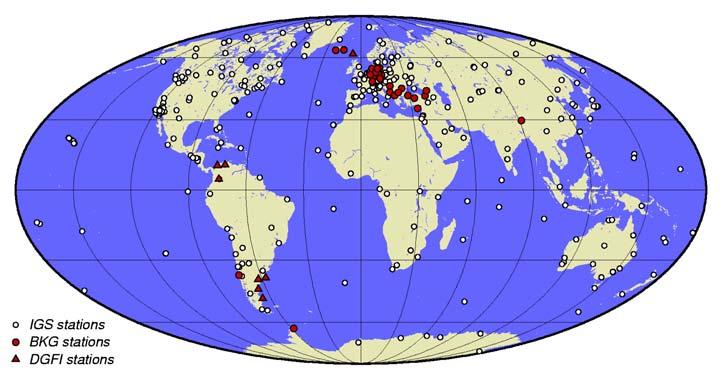
14 IGS-global Network

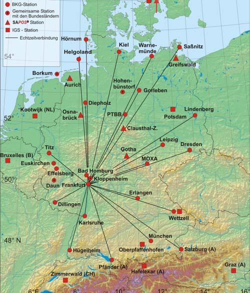
15 Fundamental Stations Wettzell und TIGO Collocation of geodetic space techniques control complementary continuous unification of ITRF local ties FS-Wettzell VLBI, SLR, GPS: Matera, Italy Shanghai, China Keystone, Japan Hartebeesthoeck,S.- Afrika Greenbelt, USA TIGO
16 Tasks of F S W Provision of Observations Contribution to International Programs Space Techniques Very Long Baseline Interferometry (VLBI) Laser Ranging to Satellites and Moon (SLR/LLR) Microwave techniques (GPS, GLONASS, DORIS, PRARE) In situ observations (T&F, Gravimetry, Meteorology, Seismography) Operation of TIGO in Chile Operation of GARS O Higgins Operation of permanent GPS/GLONASS Stations Development of the techniques (e.g. SOS_W) Development of new observing methods (Ringlaser)
17 Research Group Satellite Geodesy (FGS) Agreement on Cooperation Bundesamt für Kartographie und Geodäsie (BKG) Deutsches Geodätisches Forschungsinstitut (DGFI) Technische Universität München (TUM) Institut für Astronomische und Physikalische Geodäsie (IAPG) Forschungseinrichtung Satellitengeodäsie (FESG) Geodätisches Institut der Universität Bonn (GIUB) Operation of Fundamentalstation Wettzell by Bundesamt für Kartographie und Geodäsie (BKG) Forschungseinrichtung Satellitengeodäsie (FESG)


18 VLBI-Activities 9m O Higgins 20m RTW 6m TIGO Observations FSW > 3,5 d/w a 24h INTENSIVES TIGO > 2.5 d/w a 24h O Higgins (campaigns) Maintenance Highly reliable operations Equipped with MK5 data acquisition systems e-vlbi (Internet, INT) Future Developments TWIN telescope IVS- Next Generation VLBI (VISION 2010)


19 WLRS: Wettzell Laser Ranging System 75cm Telescope LAGEOS Reflector on the Moon Satellites LAGEOS1 LAGEOS2 Starlette Stella ETALON1 ETALON2 GPS35 GPS 36 6 GLONASS ERS1 ERS 2 ENVISAT AJISAI BEACON TOPEX Moon ILRS NASA Apollo missions Russian missions


20 SLR/LLR activities WLRS TIGO-SLR SOS-W Continuous observations WLRS: 24h per day, all over the year 360d TIGO: ~24h per day, all over the year Maintennance For robust operation Quality Control Development of the new SLR- Systems SOS-W state of the art automatic operation Ti Sapp-Laser 1kHz-repetition rate
21 GPS/GLONASS - FSW GREF IGS EUREF

22 GPS time series


23 Time and Frequency (T&F) Cs-standard T&F-control board Epoch 10ns with reference to UTC Frequency absolute relative Time systems 5 Cs-standards 3 H-Maser GPS-time transfer H-Maser UTC(Wettzell)

24 TIGO, Transportable Integrated Geodetic Observatory Since April 2002 VLBI: operation for IVS SLR: operation for ILRS GPS: operation for IGS


25 GARS O Higgins German Antarctic Receiving Station BKG und DLR VLBI GPS/GLONASS tide gauges

26 Ring Laser /Laser gyroscope local sensor for rotations daily variations of Earth rotation real time data access co-operation: BKG, FESG, Univ. Canterbury

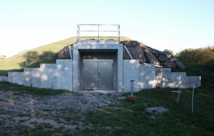
27 G

28 Underground Laboratory G

29 View from the outside
30 Results G
31 Thank you
GG S. Internal Vision of GGOS. Markus Rothacher. GFZ Potsdam
 Internal Vision of GGOS Markus Rothacher GFZ Potsdam GGOS Retreat DGFI in Munich February 15-16, 2006 Contents Motivation Four Levels of Products of the IAG Services: First Level: Raw Data Collection Second
Torsten Mayer-Gürr Institute of Geodesy, NAWI Graz Technische Universität Graz
 GGOS and Reference Systems Introduction 2015-10-12 Torsten Mayer-Gürr Institute of Geodesy, NAWI Graz Technische Universität Graz Torsten Mayer-Gürr 1 Course and exam Lecture Monday 14:00 16:00, A111 (ST01044)
Delay compensated Optical Time and Frequency Distribution for Space Geodesy
 Delay compensated Optical Time and Frequency Distribution for Space Geodesy U. Schreiber 1, J. Kodet 1, U. Hessels 2, C. Bürkel 2 1 Technische Universität München, GO- Wettzell 2 Bundesamt für Kartographie
Geodetic Observatory Wettzell - 20m Radiotelescope Status Report of
 Geodetic Observatory Wettzell - 20m Radiotelescope Status Report of 2009-2010 Alexander Neidhardt 1, Gerhard Kronschnabl 2, Raimund Schatz 1 1 Forschungseinrichtung Satellitengeodäsie (FESG), Technische
Originally published as:
 Originally published as: Seitz M., Steigenberger P., Artz T. (2xx) Consistent adjustment of combined terrestrial and celestial reference frames, Earth on the Edge: Science for a Sustainable Planet, IAG
Lecture 2 Measurement Systems. GEOS 655 Tectonic Geodesy
 Lecture 2 Measurement Systems GEOS 655 Tectonic Geodesy VLBI and SLR VLBI Very Long Baseline Interferometry SLR Satellite Laser Ranging Very Long Baseline Interferometry VLBI Geometric Delay δg S Baseline
Common Realization of Terrestrial and Celestial Reference Frame
 Common Realization of Terrestrial and Celestial Reference Frame M. Seitz, R. Heinkelmann, P. Steigenberger, T. Artz Abstract The realization of the International Celestial Reference System (ICRS) and the
The Global Geodetic Observing System (GGOS) of the International Association of Geodesy (IAG)
 of the International Association of Geodesy (IAG)") The Global Geodetic Observing System (GGOS) of the International Association of Geodesy (IAG) Hermann Drewes Representative of the International Union of Geodesy and Geophysics (IUGG) to the Cartographic
The Global Geodetic Observing System (GGOS) of the International Association of Geodesy (IAG) Hermann Drewes Representative of the International Union of Geodesy and Geophysics (IUGG) to the Cartographic
GG S Global Geodetic Observing System (GGOS): Status and Future. Markus Rothacher, Ruth Neilan, Hans-Peter Plag
: Status and Future. Markus Rothacher, Ruth Neilan, Hans-Peter Plag") 2020 Global Geodetic Observing System (GGOS): Status and Future Markus Rothacher, Ruth Neilan, Hans-Peter Plag GeoForschungsZentrum Potsdam (GFZ) Jet Propulsion Laboratory (JPL) University of Nevada, Reno
2020 Global Geodetic Observing System (GGOS): Status and Future Markus Rothacher, Ruth Neilan, Hans-Peter Plag GeoForschungsZentrum Potsdam (GFZ) Jet Propulsion Laboratory (JPL) University of Nevada, Reno
INTERNATIONAL SLR SERVICE
 ARTIFICIAL SATELLITES, Vol. 46, No. 4 2011 DOI: 10.2478/v10018-012-0004-z INTERNATIONAL SLR SERVICE Stanisław Schillak Space Research Centre, Polish Academy of Sciences Astrogeodynamic Observatory, Borowiec
Challenges and Perspectives for TRF and CRF Determination
 , IVS 2012 General Meeting Proceedings, p.309 313 http://ivscc.gsfc.nasa.gov/publications/gm2012/boehm.pdf Johannes Böhm 1, Zinovy Malkin 2, Sebastien Lambert 3, Chopo Ma 4 1) Vienna University of Technology
Earth gravity field recovery using GPS, GLONASS, and SLR satellites
 Earth gravity field recovery using GPS, GLONASS, and SLR satellites Krzysztof Sośnica (1), Adrian Jäggi (1), Daniela Thaller (2), Ulrich Meyer (1), Gerhard Beutler (1), Rolf Dach (1) (1) Astronomical Institute,
A Unique Reference Frame: Basis of the Global Geodetic Observing System (GGOS) for Geodynamics and Global Change
 for Geodynamics and Global Change") SRTM (InSAR) A Unique Reference Frame: Basis of the Global Geodetic Observing System (GGOS) for Geodynamics and Global Change Hermann Drewes President IAG Commission 1 Reference Frames Deutsches Geodätisches
SRTM (InSAR) A Unique Reference Frame: Basis of the Global Geodetic Observing System (GGOS) for Geodynamics and Global Change Hermann Drewes President IAG Commission 1 Reference Frames Deutsches Geodätisches
GGOS The Global Geodetic Observing System of the International Association of Geodesy (IAG)
") GGOS The Global Geodetic Observing System of the International Association of Geodesy (IAG) Hansjörg KUTTERER, Germany Key words: Geodetic Reference Frames, Global Geodetic Observing System, International
GGOS The Global Geodetic Observing System of the International Association of Geodesy (IAG) Hansjörg KUTTERER, Germany Key words: Geodetic Reference Frames, Global Geodetic Observing System, International
GGOS Bureau for Standards and Conventions
 GGOS D. Angermann (1), T. Gruber (2), J. Bouman (1), M. Gerstl (1), R. Heinkelmann (1), U. Hugentobler (2), L. Sánchez (1), P. Steigenberger (2) (1) Deutsches Geodätisches Forschungsinstitut (DGFI), München
Local Ties Between the Reference Points at the. with the Transportable Integrated Geodetic Observatory (TIGO) in Concepcion/Chile
 in Concepcion/Chile") Local Ties Between the Reference Points at the Transportable Integrated Geodetic Observatory (TIGO) in Concepcion/Chile Wolfgang Schlüter 1, Hayo Hase 3, Rudolf Zernecke 2, Swetlana Becker 2, Thomas Klügel
Local Ties Between the Reference Points at the Transportable Integrated Geodetic Observatory (TIGO) in Concepcion/Chile Wolfgang Schlüter 1, Hayo Hase 3, Rudolf Zernecke 2, Swetlana Becker 2, Thomas Klügel
El proyecto Sistema de Observación Geodésico Global [Global Geodetic Observing System (GGOS)] de la Asociación Internacional de Geodesia (IAG)
![El proyecto Sistema de Observación Geodésico Global [Global Geodetic Observing System (GGOS)] de la Asociación Internacional de Geodesia (IAG)](/thumbs/79/79010389.jpg "El proyecto Sistema de Observación Geodésico Global [Global Geodetic Observing System (GGOS)] de la Asociación Internacional de Geodesia (IAG)") El proyecto Sistema de Observación Geodésico Global [Global Geodetic Observing System (GGOS)] de la Asociación Internacional de Geodesia (IAG) Hermann Drewes Deutsches Geodätisches Forschungsinstitut (DGFI)
El proyecto Sistema de Observación Geodésico Global [Global Geodetic Observing System (GGOS)] de la Asociación Internacional de Geodesia (IAG) Hermann Drewes Deutsches Geodätisches Forschungsinstitut (DGFI)
Towards a Rigorous Combination of Space Geodetic Techniques
 Towards a Rigorous Combination of Space Geodetic Techniques Markus Rothacher Forschungseinrichtung Satellitengeodäsie, TU Munich, Germany Abstract: The with all its different components and products, ranging
Earth gravity field recovery using GPS, GLONASS, and SLR satellites
 13-01-08 Earth gravity field recovery using GPS, GLONASS, and SLR satellites Krzysztof Sośnica (1), Adrian Jäggi (1), Daniela Thaller (2), Ulrich Meyer (1), Christian Baumann (1), Rolf Dach (1), Gerhard
The Global Geodetic Observing System (GGOS) of the International Association of Geodesy, IAG
 of the International Association of Geodesy, IAG") The Global Geodetic Observing System (GGOS) of the International Association of Geodesy, IAG Hans-Peter Plag (1), Markus Rothacher (2), Richard Gross (3), Srinivas Bettadpur (4) (1) Nevada Bureau of Mines
The Global Geodetic Observing System (GGOS) of the International Association of Geodesy, IAG Hans-Peter Plag (1), Markus Rothacher (2), Richard Gross (3), Srinivas Bettadpur (4) (1) Nevada Bureau of Mines
Global reference systems and Earth rotation
 current realizations and scientific problems Aleksander Brzeziński 1,2, Tomasz Liwosz 1, Jerzy Rogowski 1, Jan Kryński 3 1 Department of Geodesy and Geodetic Astronomy Warsaw University of Technology 2
New satellite mission for improving the Terrestrial Reference Frame: means and impacts
 Fourth Swarm science meeting and geodetic missions workshop ESA, 20-24 March 2017, Banff, Alberta, Canada New satellite mission for improving the Terrestrial Reference Frame: means and impacts Richard
Establishment of a Global Absolute Gravity Network
 Establishment of a Global Absolute Gravity Network H. Wilmes 1), H. Wziontek 1), R. Falk 1), J. Ihde 1), S. Bonvalot 2), R. Forsberg 3), S. Kenyon 4), L. Vitushkin 5) 1) Federal Agency for Cartography
GGOS The Global Geodetic Observing System of the International Association of Geodesy
 GGOS The Global Geodetic Observing System of the International Association of Geodesy Presented at the FIG Working Week 2017, May 29 - June 2, 2017 in Helsinki, Finland Hansjörg Kutterer BKG, Germany Content
GGOS INFORMATION MODELS: ANALYSIS OF INTERRELATIONS BETWEEN OBSERVATION TECHNIQUES AND THE EARTH GRAVITY FIELD
 GGOS INFORMATION MODELS: ANALYSIS OF INTERRELATIONS BETWEEN OBSERVATION TECHNIQUES AND THE EARTH GRAVITY FIELD Wojciech Pachelski 1) Małgorzata Paśnicka-Pawłowska 2) Karolina Szafranek 3) Agnieszka Zwirowicz
Global & National Geodesy, GNSS Surveying & CORS Infrastructure
 Global & National Geodesy, GNSS Surveying & CORS Infrastructure Chris Rizos School of Surveying & Spatial Information Systems University of New South Wales, Sydney, Australia President-elect, International
REGIONAL REFERENCE FRAMES: THE IAG PERSPECTIVE
 REGIONAL REFERENCE FRAMES: THE IAG PERSPECTIVE João Agria Torres SPUIAGG IAG Sub-commission 1.3: Regional Reference Frames jatorres@iol.pt 1. About the IAG CONTENT 2. Objectives and organization of SC
GNSS-specific local effects at the Geodetic Observatory Wettzell
 GNSS-specific local effects at the Geodetic Observatory Wettzell Peter Steigenberger, Urs Hugentobler, Ralf Schmid Technische Universität München (TUM) Uwe Hessels, Thomas Klügel Bundesamt für Kartographie
Strategy for the Realization of the International Height Reference System (IHRS)
") Deutsches Geodätisches Forschungsinstitut (DGFI-TUM) Technische Universität München Strategy for the Realization of the International Height Reference System (IHRS) Laura Sánchez 1, Johannes Ihde 2, Roland
Deutsches Geodätisches Forschungsinstitut (DGFI-TUM) Technische Universität München Strategy for the Realization of the International Height Reference System (IHRS) Laura Sánchez 1, Johannes Ihde 2, Roland
3.4.2 International Laser Ranging Service (ILRS)
") 3 Reports of IERS components 3.4 Technique Centres 3.4.2 International Laser Ranging Service (ILRS) Introduction Network The International Laser Ranging Service (ILRS), established in 1998, is responsible
3 Reports of IERS components 3.4 Technique Centres 3.4.2 International Laser Ranging Service (ILRS) Introduction Network The International Laser Ranging Service (ILRS), established in 1998, is responsible
Assessment of the International Terrestrial Reference System 2014 realizations by Precise Orbit Determination of SLR Satellites
 Deutsches Geodätisches Forschungsinstitut (DGFI-TUM) Technische Universität München Assessment of the International Terrestrial Reference System 2014 realizations by Precise Orbit Determination of SLR
Publ. Astron. Obs. Belgrade No. 91 (2012), REALIZATION OF ETRF2000 AS A NEW TERRESTRIAL REFERENCE FRAME IN REPUBLIC OF SERBIA
, REALIZATION OF ETRF2000 AS A NEW TERRESTRIAL REFERENCE FRAME IN REPUBLIC OF SERBIA") Publ. Astron. Obs. Belgrade No. 91 (2012), 199-206 Contributed paper REALIZATION OF ETRF2000 AS A NEW TERRESTRIAL REFERENCE FRAME IN REPUBLIC OF SERBIA D. BLAGOJEVIĆ and V. VASILIĆ Faculty of Civil Engineering,
Publ. Astron. Obs. Belgrade No. 91 (2012), 199-206 Contributed paper REALIZATION OF ETRF2000 AS A NEW TERRESTRIAL REFERENCE FRAME IN REPUBLIC OF SERBIA D. BLAGOJEVIĆ and V. VASILIĆ Faculty of Civil Engineering,
The Interactions between IGS and GGOS
 The Interactions between IGS and GGOS Markus Rothacher Institute of Geodesy and Photogrammetry (IGP) ETH Zurich, Switzerland 2012 IGS Workshop July 23-27, 2012, Olsztyn, Poland Overview GGOS Vision, Mission
Status. EUREF TWG Meeting November 8 9, 2004, Praha
 ECGN was initiated by IAG Sub-Commission for Europe EUREF (SC1.3a) and IAG Sub-Commission for Europe of the International Gravity and Geoid Commission (IGGC) with relationship to Joint Research Centre
Geodetic Observing Systems: tools in observing the Glacial Isostatic Adjustment. Markku Poutanen Finnish Geodetic Institute
 Geodetic Observing Systems: tools in observing the Glacial Isostatic Adjustment Markku Poutanen Finnish Geodetic Institute Glacial Isostatic Adjustment Land uplift is just one consequence of the physical
Integration of space and terrestrial techniques to study crustal deformation. Examples in northeastern Italy
 Integration of space and terrestrial techniques to study crustal deformation. Examples in northeastern Italy Susanna Zerbini Dipartimento di Fisica, University of Bologna, Italy IAG-IASPEI Joint Capacity
IGS-related multi-gnss activities at CODE
 IGS-related multi-gnss activities at CODE Lars Prange (1), Rolf Dach (1) Simon Lutz (1), Stefan Schaer (2), Adrian Jäggi (1) (1) Astronomical Institute, University of Bern, Switzerland source: http://boris.unibe.ch/57698/
Connecting terrestrial to celestial reference frames
 Russian Academy of Sciences Central Astronomical Observatory at Pulkovo IAU XXVIII General Assembly, Joint Discussion 7, Beijing, China, August 28, 2012 Connecting terrestrial to celestial reference frames
Twin Telescopes at Onsala and Wettzell and their contribution to the VGOS System
 Twin Telescopes at Onsala and Wettzell and their contribution to the VGOS System C. Schönberger, P. Gnilsen, J. Böhm, R. Haas Abstract During the last years the International VLBI Service for Geodesy and
Challenges and perspectives for CRF and TRF determination
 Challenges and perspectives for CRF and TRF determination J. Böhm, Z. Malkin, S. Lambert, C. Ma with contributions by H. Spicakova, L. Plank, and H. Schuh Consistency TRF EOP CRF ITRF2008 from VLBI/GNSS/SLR/DORIS
Introduction to geodetic VLBI
 Introduction to geodetic VLBI David Mayer Andreas Hellerschmied Johannes Böhm Harald Schuh and Johannes Böhm, Very Long Baseline Interferometry for Geodesy and Astrometry, in Guochang Xu (editor): Sciences
Impact of Earth Radiation Pressure on LAGEOS Orbits and on the Global Scale
 13-Po-22 Impact of Earth Radiation Pressure on LAGEOS Orbits and on the Global Scale Krzysztof Sośnica (1), Carlos Javier Rodríguez-Solano (2), Daniela Thaller (3), Adrian Jäggi (1), Rolf Dach (1), Gerhard
Consistent realization of Celestial and Terrestrial Reference Frames
 Journal of Geodesy manuscript - accepted version (minor errata corrected) The official publication is available at Springer via https://doi.org/10.1007/s00190-018-1130-6 Consistent realization of Celestial
3.6 ITRS Combination Centres
 3 Reports of IERS components 3.6.1 Deutsches Geodätisches Forschungsinstitut (DGFI) In 2010, the focus of the ITRS Combination Centre at DGFI was on the finalization of the ITRS realization DTRF2008, internal
Understanding Earth Rotation Part 2: Physical Foundations and Interpretation
 Understanding Earth Rotation Part 2: Physical Foundations and Interpretation Prof. Dr. Florian Seitz Technische Universität München (TUM) Deutsches Geodätisches Forschungsinstitut (DGFI) Munich, Germany
Role and importance of the International Terrestrial Reference Frame for sustainable development
 Role and importance of the International Terrestrial Reference Frame for sustainable development This report is provided for the benefit of participants of the UNRCC-PCGIAP Informal Geodetic Consultation,
GEOS 655 Tectonic Geodesy. Jeff Freymueller Elvey 413B, x7286
 GEOS 655 Tectonic Geodesy Jeff Freymueller jfreymueller@alaska.edu Elvey 413B, x7286 Application of Geodesy to Tectonics Uncertainties < 1 mm/y Blue: stable part of tectonic plates Red: deforming zones
Recent Advances in High Resolution Rotation Sensing
 Recent Advances in High Resolution Rotation Sensing U. Schreiber 1,2, A. Gebauer 1, R. Hurst 2, J.-P. Wells 2 1 Forschungseinrichtung Satellitengeodäsie, Technische Universität München, Germany 2 Department
From Global to National Geodetic Reference Frames: how are they connected and why are they needed?
 From Global to National Geodetic Reference Frames: how are they connected and why are they needed? Zuheir ALTAMIMI Institut National de l Information Géographique et Forestière, France Vice-President,
Co-location of VLBI with other techniques in space: a simulation study
 Co-location of VLBI with other techniques in space: a simulation study B. Männel, M. Rothacher ETH Zürich, Geodesy and Geodynamics Lab 7 th IGS General Meeting, Madrid 212 1 Reference frame and local ties
Contributions of Geodesy to Oceanography
 Contributions of Geodesy to Oceanography B. Tapley and J. Ries Center for Space Research, The University of Texas at Austin Dynamic Planet 2005 Cairns, Australia August 22-26, 2005 August 22-26, 2005 Dynam
Simulations of VLBI observations with the Onsala Twin Telescope
 Simulations of VLBI observations with the Onsala Twin Telescope Master of Science Thesis CAROLINE SCHÖNBERGER Department of Earth and Space Sciences Division of Space Geodesy and Geodynamics CHALMERS UNIVERSITY
VLBI: A Fascinating Technique for Geodesy and Astrometry
 VLBI: A Fascinating Technique for Geodesy and Astrometry Annual Conference Satellite methods and position determination in modern surveying and navigation Wroclaw, June 2-3, 2011 Harald Schuh VLBI, Wroclaw,
The 2008 Local-tie Survey at the Onsala Space Observatory
 The 2008 Local-tie Survey at the Onsala Space Observatory M. Lösler, Geodetic Institute of the University of Karlsruhe (TH), DE-76128 Karlsruhe, Germany R. Haas Department of Radio and Space Science, Chalmers
Analysis Strategies And Software For Geodetic VLBI
 Analysis Strategies And Software For Geodetic VLBI Rüdiger Haas Presentation at the 7th EVN Symposium, Toledo, 2004 Outline: Observing stategies and observables Data analysis strategies Data analysis software
Frequent epoch reference frames instead of instant station positions and constant velocities
 Deutsches Geodätisches Forschungsinstitut Technische Universität München (DGFI-TUM) Frequent epoch reference frames instead of instant station positions and constant velocities Hermann Drewes Deutsches
Progress Report on the WLRS: Getting ready for GGOS, LLR and Time Transfer
 13-0219 Progress Report on the WLRS: Getting ready for GGOS, LLR and Time Transfer G. Herold (1), J. Eckl (1), M. Mühlbauer (1), A. Leidig (1), J. Kodet (2), U. Schreiber (2) (1) Geodetic Observatory Wettzell,
Proceedings of the IERS Workshop on Combination Research and Global Geophysical Fluids
 International Earth Rotation and Reference Systems Service () Service International de la Rotation Terrestre et des Systèmes de Référence No. 30 Proceedings of the Workshop on Combination Research and
Satellite Geodesy and Navigation Present and Future
 Satellite Geodesy and Navigation Present and Future Drazen Svehla Institute of Astronomical and Physical Geodesy Technical University of Munich, Germany Content Clocks for navigation Relativistic geodesy
GGOS, ECGN and NGOS: Global and regional geodetic observing systems. Markku Poutanen Finish Geodetic Institute
 GGOS, ECGN and NGOS: Global and regional geodetic observing systems Markku Poutanen Finish Geodetic Institute Contents GGOS, ECGN, NGOS Why? How? Future? (geodesy) GGOS Structure GGOS Structure European
ECGN - Development of the European Combined Geodetic Network in Austria
 ECGN - Development of the European Combined Geodetic Network in Austria Diethard Ruess 1, Gelöscht: BEV Dept. Control Survey Abstract Austria takes part in the European Combined Geodetic Network - Project
A Strategic Plan for Geodesy in Sweden. Mikael Lilje Lars E. Engberg Geodesy Department Lantmäteriet Sweden
 A Strategic Plan for Geodesy in Sweden Mikael Lilje Lars E. Engberg Geodesy Department Lantmäteriet Sweden Our vision is to be able to meet Swedish society s needs for a homogeneous, sustainable geodetic
The International Terrestrial Reference Frame. What is a Terrestrial Reference Frame?
 The International Terrestrial Reference Frame As early as the 15th century, Swedes noticed that rocks in their harbors were slowly rising out of the sea [Ekman, 1991]. These local observations were not
Gaia Astrometry Upkeeping by GNSS - Evaluation Study [GAUGES]
![Gaia Astrometry Upkeeping by GNSS - Evaluation Study [GAUGES]](/thumbs/92/109628399.jpg "Gaia Astrometry Upkeeping by GNSS - Evaluation Study [GAUGES]") Gaia Astrometry Upkeeping by GNSS - Evaluation Study [GAUGES] M. Gai, A. Vecchiato [INAF-OATo] A. Fienga, F. Vakili, J.P. Rivet, D. Albanese [OCA] Framework: Development of High Precision Astrometric Techniques
Gaia Astrometry Upkeeping by GNSS - Evaluation Study [GAUGES] M. Gai, A. Vecchiato [INAF-OATo] A. Fienga, F. Vakili, J.P. Rivet, D. Albanese [OCA] Framework: Development of High Precision Astrometric Techniques
GINS: a new tool for VLBI Geodesy and Astrometry
 GINS: a new tool for VLBI Geodesy and Astrometry G. Bourda, P. Charlot, R. Biancale 2 () Observatoire Aquitain des Sciences de l Univers - Université Bordeaux I Laboratoire d Astrophysique de Bordeaux
GGOS. Global Geodetic Observing System. Carey Noll NASA GSFC (on behalf of GGOS) WDS Forum September 11, 2016
 WDS Forum September 11, 2016") https://ntrs.nasa.gov/search.jsp?r=20160011397 2018-12-07T18:04:29+00:00Z GGOS Global Geodetic Observing System Carey Noll NASA GSFC (on behalf of GGOS) WDS Forum September 11, 2016 Global Geodetic Observing
https://ntrs.nasa.gov/search.jsp?r=20160011397 2018-12-07T18:04:29+00:00Z GGOS Global Geodetic Observing System Carey Noll NASA GSFC (on behalf of GGOS) WDS Forum September 11, 2016 Global Geodetic Observing
Effects of Climate Change on Earth s Parameters An Example of Exabyte-sized System
 Effects of Climate Change on Earth s Parameters An Example of Exabyte-sized System Giampiero Sindoni 1, Erricos. C. Pavlis 2, Claudio Paris 3,1, Antonio Paolozzi 1,3 and Ignazio Ciufolini 4,3 1 Scuola
Update on the International Terrestrial Reference Frame (ITRF) : ITRF2014. Zuheir Altamimi
 : ITRF2014. Zuheir Altamimi") Update on the International Terrestrial Reference Frame (ITRF) : ITRF2014 Zuheir Altamimi Head of the IERS ITRF Product Center IAG Vice President IGN, France E-mail: zuheir.altamimi@ign.fr Key Points Introduction:
Update on the International Terrestrial Reference Frame (ITRF) : ITRF2014 Zuheir Altamimi Head of the IERS ITRF Product Center IAG Vice President IGN, France E-mail: zuheir.altamimi@ign.fr Key Points Introduction:
Toward a direct combination of space-geodetic techniques at the measurement level: Methodology and main issues
 Click Here for Full Article JOURNAL OF GEOPHYSICAL RESEARCH, VOL. 112,, doi:10.1029/2006jb004336, 2007 Toward a direct combination of space-geodetic techniques at the measurement level: Methodology and
SIRGAS: Basis for Geosciences, Geodata, and Navigation in Latin America
 SIRGAS: Basis for Geosciences, Geodata, and Navigation in Latin America Claudio Brunini President of SIRGAS Universidad Nacional de La Plata, Argentina María Virginia Mackern President of SIRGAS/WG-I:
The celestial reference system and its role in the epoch of global geodetic technologies
 Reports on Geodesy, vol. 92, no. 1, 2012 The celestial reference system and its role in the epoch of global geodetic technologies Jerzy B. Rogowski 1, Aleksander Brzeziński 1,2 1 Warsaw University of Technology,
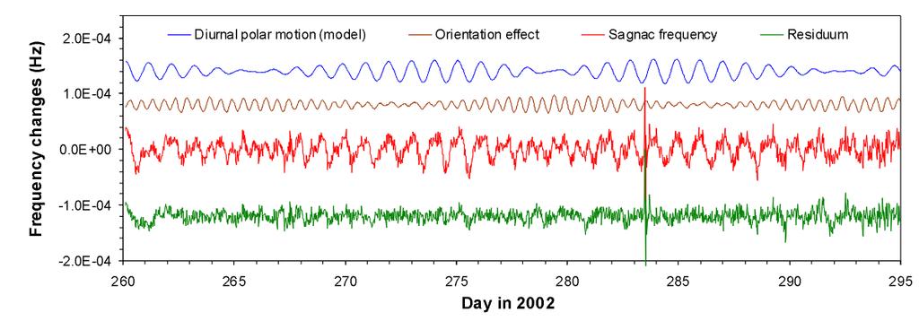
Direct measurement of diurnal polar motion by ring laser gyroscopes
 JOURNAL OF GEOPHYSICAL RESEARCH, VOL. 109,, doi:10.1029/2003jb002803, 2004 Direct measurement of diurnal polar motion by ring laser gyroscopes K. U. Schreiber, A. Velikoseltsev, and M. Rothacher Forschungseinrichtung
Coordinate Systems for Astronomy or: How to get your telescope to observe the right object
 Coordinate Systems for Astronomy or: How to get your telescope to observe the right object Figure 1: Basic definitions for the Earth Definitions - Poles, Equator, Meridians, Parallels The rotation of the
Ludwig Combrinck HartRAO 3rd Space Geodesy Workshop 16 March 2009 Matjiesfontein
 Space Geodesy and Space Science Ludwig Combrinck HartRAO 3rd Space Geodesy Workshop 16 March 2009 Matjiesfontein DST s Concept of Space Science SA Space Agency, commercial applications, CSIR Satellite
Impact of A Priori Gradients on VLBI-Derived Terrestrial Reference Frames
 Impact of A Priori Gradients on VLBI-Derived Terrestrial Reference Frames J. Böhm, H. Spicakova, L. Urquhart, P. Steigenberger, H. Schuh Abstract We compare the influence of two different a priori gradient
ESTIMATION OF NUTATION TERMS USING GPS
 ESTIMATION OF NUTATION TERMS USING GPS Markus Rothacher, Gerhard Beutler Astronomical Institute, University of Berne CH-3012 Berne, Switzerland ABSTRACT Satellite space-geodetic measurements have been
Impact of A Priori Gradients on VLBI-Derived Terrestrial Reference Frames
 Impact of A Priori Gradients on VLBI-Derived Terrestrial Reference Frames J. Böhm, H. Spicakova, L. Urquhart, P. Steigenberger, H. Schuh Abstract We compare the influence of two different a priori gradient
Geodetic and astrometric Very Long Baseline Interferometry (VLBI) - the IVS and its future perspectives
 - the IVS and its future perspectives") Geodetic and astrometric Very Long Baseline Interferometry (VLBI) - the IVS and its future perspectives EGU and IVS Training School on VLBI for Geodesy and Astrometry Aalto University, Espoo, Finland 2
Geodetic and astrometric Very Long Baseline Interferometry (VLBI) - the IVS and its future perspectives EGU and IVS Training School on VLBI for Geodesy and Astrometry Aalto University, Espoo, Finland 2
Test Computations
 158 7. Test Computations.3.2.1 -.1 -.2 Fourier index 2.8.4 -.4 -.8 Fourier index 2.2.1 -.1 -.2 Fourier index 3.8.4 -.4 -.8 Fourier index 3.2.1 -.1 -.2 -.3 Fourier index 4.8.4 -.4 -.8 Fourier index 4.2.1
arxiv:physics/ v1 30 Jun 2004
 JOURNAL OF GEOPHYSICAL RESEARCH, VOL. 109, B06405, doi:10.1029/2003jb002803, 2004 arxiv:physics/0406156 v1 30 Jun 2004 Direct measurement of diurnal polar motion by ring laser gyroscopes K. U. Schreiber,
Geodesy Part of the ACES Mission: GALILEO on Board the International Space Station
 Geodesy Part of the ACES Mission: GALILEO on Board the International Space Station 1 Svehla D, 2 Rothacher M, 3 Salomon C, 2 Wickert J, 2 Helm A, 2 Beyerle, G, 4 Ziebart M, 5 Dow J 1 Institute of Astronomical
The Second Realization of the International Celestial Reference Frame
 ICRF2 Highlights Work done by IERS/IVS and IAU Working Groups A truly international team Constructed using 30 Years of Very Long Baseline Interferometry data 4 times more observations than ICRF1 Improved
The conversion of Universal Time to Greenwich Mean Sidereal Time is rigorously possible and is given by a series development with time defined by
 2.2 Time Systems 23 A = LAST - GAST = LMST -GMST. (2.5) LAST is detennined from astronomical observations to fixed stars and extragalactic radio sources. The mean sidereal time scale is still affected
Overview of the ILRS contribution to the development of ITRF2013
 Overview of the ILRS contribution to the development of ITRF203 V. Luceri, E. C. Pavlis 2, B. Pace, D. König 2, M. Kuzmicz-Cieslak 2, G. Bianco 3 ) e-geos S.p.A., Centro di Geodesia Spaziale, Matera, Italy
VLBI: A Fascinating Technique for Geodesy and Astrometry. Vening Meinesz Medal Lecture by Harald Schuh
 VLBI: A Fascinating Technique for Geodesy and Astrometry Vening Meinesz Medal Lecture by Harald Schuh F. A. Vening Meinesz (1887-1966) conducted several global gravity surveys On the basis of his observational
Atmospheric Effects in Space Geodesy
 Atmospheric Effects in Space Geodesy Johannes Böhm 18 November 2011 @ UNESP, Presidente Prudente, Brazil The atmosphere.. is not only causing troubles in space geodesy.. but it opens up a wide field of
SLR Graz: khz Satellite Laser Ranging & Co
 Graz in Space 2014 KFU Graz 4. 5. September 2014 SLR Graz: khz Satellite Laser Ranging & Co Georg Kirchner, Franz Koidl, Oliver Baur Space Research Institute Austrian Academy of Sciences Outline What is
DETERMINATION OF THE STATION COORDINATES FOR QUALITY CONTROL OF THE SATELLITE LASER RANGING DATA S.
 DETERMINATION OF THE STATION COORDINATES FOR QUALITY CONTROL OF THE SATELLITE LASER RANGING DATA S. Schillak Space Research Centre of the Polish Academy of Sciences. Astrogeodynamic Observatory, Borowiec
Global Mapping Function (GMF): A new empirical mapping function based on numerical weather model data
: A new empirical mapping function based on numerical weather model data") Johannes Böhm, Arthur Niell, Paul Tregoning, and Harald Schuh Global Mapping Function (GMF): A new empirical mapping function based on numerical weather model data Geophysical Research Letters Vol. 33,
Johannes Böhm, Arthur Niell, Paul Tregoning, and Harald Schuh Global Mapping Function (GMF): A new empirical mapping function based on numerical weather model data Geophysical Research Letters Vol. 33,
Call for space geodetic solutions corrected for non-tidal atmospheric loading (NT-ATML) at the observation level
 at the observation level") Call for space geodetic solutions corrected for non-tidal atmospheric loading (NT-ATML) at the observation level Xavier Collilieux, Tonie van Dam, Zuheir Altamimi Outline: Context Why correcting for non-tidal
Call for space geodetic solutions corrected for non-tidal atmospheric loading (NT-ATML) at the observation level Xavier Collilieux, Tonie van Dam, Zuheir Altamimi Outline: Context Why correcting for non-tidal
Report for 15th PCGIAP Meeting at 18th UNRCC-AP Working Group 1 Regional Geodesy
 Report for 15th PCGIAP Meeting at 18th UNRCC-AP Working Group 1 Regional Geodesy Chairman Shigeru Matsuzaka, Japan - shigeru@gsi.go.jp Vice Chairman Prof. Pengfei Cheng, China - chengpf@casm.ac.cn John
Geodetic Very Long Baseline Interferometry (VLBI)
") Geodetic Very Long Baseline Interferometry (VLBI) A brief Note compiled by: Prof. Madhav N. Kulkarni, IIT Bombay Since the inception of the Very Long Baseline Interferometry (VLBI) system in 1967, this
Geodetic Very Long Baseline Interferometry (VLBI) A brief Note compiled by: Prof. Madhav N. Kulkarni, IIT Bombay Since the inception of the Very Long Baseline Interferometry (VLBI) system in 1967, this
The Global Mapping Function (GMF): A new empirical mapping function based on numerical weather model data
: A new empirical mapping function based on numerical weather model data") The Global Mapping Function (GMF): A new empirical mapping function based on numerical weather model data J. Boehm, A. Niell, P. Tregoning, H. Schuh Troposphere mapping functions are used in the analyses
The Global Mapping Function (GMF): A new empirical mapping function based on numerical weather model data J. Boehm, A. Niell, P. Tregoning, H. Schuh Troposphere mapping functions are used in the analyses
The International Terrestrial Reference System and ETRS89: Part II : ITRS & ETRS89 relationship
 The International Terrestrial Reference System and ETRS89: Part II : ITRS & ETRS89 relationship Zuheir ALTAMIMI Laboratoire de Recherche en Géodésie Institut national de l information géographique et forestière
On the accuracy assessment of celestial reference frame realizations
 J Geod (2008) 82:325 329 DOI 10.1007/s00190-007-0181-x ORIGINAL ARTICLE On the accuracy assessment of celestial reference frame realizations Z. Malkin Received: 4 March 2007 / Accepted: 19 July 2007 /
Recent and Anticipated Changes to the International Earth Rotation and Reference Systems Service (IERS) Conventions
 Conventions") Recent and Anticipated Changes to the International Earth Rotation and Reference Systems Service (IERS) Conventions Brian Luzum, U.S. Naval Observatory BIOGRAPHY Brian Luzum began full-time employment
Recent and Anticipated Changes to the International Earth Rotation and Reference Systems Service (IERS) Conventions Brian Luzum, U.S. Naval Observatory BIOGRAPHY Brian Luzum began full-time employment
History of VLBI the IVS, and the next generation of VLBI. H. Schuh, L. Plank
 History of VLBI the IVS, and the next generation of VLBI H. Schuh, L. Plank Evolution of VLBI 60ies: First realization in Canada (Broten et al.,1967) and in the U.S.A. (Bare et al., 1967, Shapiro, 1968)
Radio Interferometry and VLBI. Aletha de Witt AVN Training 2016
 Radio Interferometry and VLBI Aletha de Witt AVN Training 2016 Radio Interferometry Single element radio telescopes have limited spatial resolution θ = 1.22 λ/d ~ λ/d Resolution of the GBT 100m telescope
COMBINING GPS AND VLBI MEASUREMENTS OF CELESTIAL MOTION OF THE EARTH S SPIN AXIS AND UNIVERSAL TIME. Jan VONDRÁK* and Cyril RON
 Acta Geodyn. Geomater., Vol.2, No.3 (139), 87-94, 2005 COMBINING GPS AND VLBI MEASUREMENTS OF CELESTIAL MOTION OF THE EARTH S SPIN AXIS AND UNIVERSAL TIME Jan VONDRÁK* and Cyril RON Department of Galaxies
Analysis and application of 1-way laser ranging data to LRO
 www.dlr.de Chart 1 WLRS ranging to LRO Analysis and application of 1-way laser ranging data to LRO S. Bauer (1), J. Oberst (1,2), H. Hussmann (1), P. Gläser (2), U. Schreiber (3), D. Mao (4), G. Neumann