GNSS-specific local effects at the Geodetic Observatory Wettzell
|
|
|
- Samuel Powers
- 6 years ago
- Views:
Transcription
1 GNSS-specific local effects at the Geodetic Observatory Wettzell Peter Steigenberger, Urs Hugentobler, Ralf Schmid Technische Universität München (TUM) Uwe Hessels, Thomas Klügel Bundesamt für Kartographie und Geodäsie (BKG), Geodetic Observatory Wettzell Manuela Seitz Deutsches Geodätisches Forschungsinstitut (DGFI), München
2 Motivation and Outline Local tie height discrepancies at Wettzell from DTRF2008 GPS VLBI GPS SLR GPS GPS Outline GNSS network at Wettzell GNSS processing Frequency-dependent systematic effects on station coordinates Residual maps igs08.atx receiver antenna calibrations Conclusions
3 Local Surveys Horizontal displacement Vertical displacement WTZR WTZT WTZR WTZJ WTZA WTZZ WTZL WTZA 1 mm The precision of the local ties in Wettzell is at the 1-2 mm level


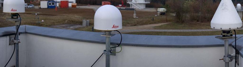
4 GNSS Sites at Wettzell Data analyzed from 329/ /2011 WTZA WTZZ WTZR WTZJ WTZA WTZZ WTZR
5 GNSS Processing Double difference solution with Bernese 5.1, IGS05 reference frame, igs05.atx antenna model WTZA as reference: no antenna change, no discontinuities Reprocessed ( ) and operational ( ) CODE products: - Satellite orbits and Earth rotation parameters Estimation of troposphere parameters for all stations but WTZA - Zenith delays with 2 h parameter spacing, VMF1, ECMWF - One pair of east-west and north-south gradients per day - Elevation-dependent weighting: cos 2 z Ambiguity fixing for L1 and L2 with Sigma method, mean resolution rate of 99.5% Computation of L1, L2, and L3 (ionosphere-free) solutions
6 WTZR w.r.t. WTZA with Troposphere Estimation Antenna change Local Tie L1 L2 L3


7 WTZR w.r.t. WTZA with Troposphere Estimation Antenna change Local Tie Microwave absorber plate installed L1 L2 L3

8 Cumulative Solution: Height Component Differences between baseline w.r.t. WTZA and local tie Troposphere parameters estimated L1 L2 L3 WTZT WTZJ WTZR WTZZ
9 Cumulative Solution: Height Component Differences between baseline w.r.t. WTZA and local tie Troposphere parameters estimated L1 L2 L3 WTZT WTZJ WTZR WTZZ Uncalibrated Radome
10 Impact of Troposphere Estimation L3 station height discrepancies with and without troposphere estimation WTZT WTZJ WTZR WTZZ
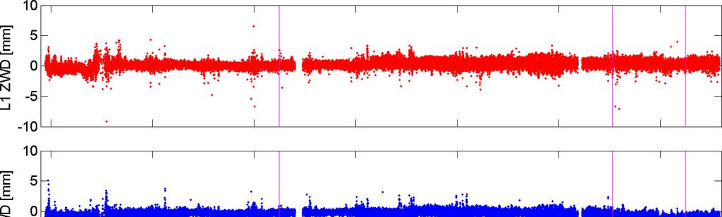
11 Troposphere Zenith Delays for WTZR
 for ionosphere-free linear combination WTZJ WTZR WTZT WTZZ Troposphere")
12 L3 Troposphere Biases Mean bias and standard deviation per solution interval (due to antenna changes) for ionosphere-free linear combination WTZJ WTZR WTZT WTZZ Troposphere Bias [mm]

13 Estimation of Residual Maps WTZT, September 1998 (uncalibrated radome) Local ties fixed No elevation-dependent weighting, 10 cut-off L3 residuals for WTZT with uncalibrated radome
![Application of Residual Maps residual-corrected with troposphere estimation L3 Solution ΔUp [mm] residual-corrected without troposphere estimation WTZT with uncalibrated](/docs-images/75/72545820/images/14-0.jpg "radome zenith-dependent corrections from September 1998 applied uncorrected without troposphere estimation Jan Mar May Jul Sep uncorrected with troposphere estimation")
14 Application of Residual Maps residual-corrected with troposphere estimation L3 Solution ΔUp [mm] residual-corrected without troposphere estimation WTZT with uncalibrated radome zenith-dependent corrections from September 1998 applied uncorrected without troposphere estimation Jan Mar May Jul Sep uncorrected with troposphere estimation 1998


15 Residual Maps: WTZR September 2008 AOAD/M_T NONE September 2009 LEIAR25 LEIT September 2010 LEIAR25.R3 LEIT Residuals [mm]
16 igs08.atx Receiver Antenna Calibrations Differences to station heights derived with igs05.atx receiver calibrations Agreement with local ties Degraded Improved WTZJ WTZR WTZT WTZZ L1 L2 L3 Updated robot calibration New robot calibration
17 Summary and Conclusions Precision of the local ties at Wettzell is at the 1-2 mm level L1, L2, and L3 GPS solutions differ by up to 5 cm L3 differences w.r.t. local ties can reach the cm level Discrepancies are caused by GPS, not the local tie measurements Discrepancies amplified by estimation of troposphere parameters Near-field effects like multipath are most likely the source for these frequency-dependent systematic effects Residual maps show systematic effects at the cm level Residual maps could be used for differential corrections (w.r.t. reference site or previous antenna at same site) Should such corrections be applied within the IGS?

18
Common Realization of Terrestrial and Celestial Reference Frame
 Common Realization of Terrestrial and Celestial Reference Frame M. Seitz, R. Heinkelmann, P. Steigenberger, T. Artz Abstract The realization of the International Celestial Reference System (ICRS) and the
Delay compensated Optical Time and Frequency Distribution for Space Geodesy
 Delay compensated Optical Time and Frequency Distribution for Space Geodesy U. Schreiber 1, J. Kodet 1, U. Hessels 2, C. Bürkel 2 1 Technische Universität München, GO- Wettzell 2 Bundesamt für Kartographie
Impact of solar radiation pressure modeling on GNSS-derived geocenter motion
 EGU 2012, Vienna, Austria Impact of solar radiation pressure modeling on GNSS-derived geocenter motion Carlos Rodriguez-Solano (1) Urs Hugentobler (1) Peter Steigenberger (1) Mathias Fritsche (2) (1) Astronomical,
GNSS Estimates of Short-period Nutation
 GNSS Estimates of Short-period Nutation Peter Steigenberger, Urs Hugentobler Technische Universität München Daniela Thaller, Simon Lutz, Rolf Dach Astronomisches Institut, Universität Bern Sarah Böckmann
Local Ties Between the Reference Points at the. with the Transportable Integrated Geodetic Observatory (TIGO) in Concepcion/Chile
 in Concepcion/Chile") Local Ties Between the Reference Points at the Transportable Integrated Geodetic Observatory (TIGO) in Concepcion/Chile Wolfgang Schlüter 1, Hayo Hase 3, Rudolf Zernecke 2, Swetlana Becker 2, Thomas Klügel
Local Ties Between the Reference Points at the Transportable Integrated Geodetic Observatory (TIGO) in Concepcion/Chile Wolfgang Schlüter 1, Hayo Hase 3, Rudolf Zernecke 2, Swetlana Becker 2, Thomas Klügel
Originally published as:
 Originally published as: Seitz M., Steigenberger P., Artz T. (2xx) Consistent adjustment of combined terrestrial and celestial reference frames, Earth on the Edge: Science for a Sustainable Planet, IAG
IGS-related multi-gnss activities at CODE
 IGS-related multi-gnss activities at CODE Lars Prange (1), Rolf Dach (1) Simon Lutz (1), Stefan Schaer (2), Adrian Jäggi (1) (1) Astronomical Institute, University of Bern, Switzerland source: http://boris.unibe.ch/57698/
Assessment of the International Terrestrial Reference System 2014 realizations by Precise Orbit Determination of SLR Satellites
 Deutsches Geodätisches Forschungsinstitut (DGFI-TUM) Technische Universität München Assessment of the International Terrestrial Reference System 2014 realizations by Precise Orbit Determination of SLR
Fundamental Station Wettzell - geodetic observatory -
 Fundamental Station Wettzell - geodetic observatory - Wolfgang Schlüter Bundesamt für Kartographie und Geodäsie, Fundamental Station Wettzell Germany Radiometer Workshop, Wettzell, 10.10.06 Evolvement
GGOS Bureau for Standards and Conventions
 GGOS D. Angermann (1), T. Gruber (2), J. Bouman (1), M. Gerstl (1), R. Heinkelmann (1), U. Hugentobler (2), L. Sánchez (1), P. Steigenberger (2) (1) Deutsches Geodätisches Forschungsinstitut (DGFI), München
A Unique Reference Frame: Basis of the Global Geodetic Observing System (GGOS) for Geodynamics and Global Change
 for Geodynamics and Global Change") SRTM (InSAR) A Unique Reference Frame: Basis of the Global Geodetic Observing System (GGOS) for Geodynamics and Global Change Hermann Drewes President IAG Commission 1 Reference Frames Deutsches Geodätisches
SRTM (InSAR) A Unique Reference Frame: Basis of the Global Geodetic Observing System (GGOS) for Geodynamics and Global Change Hermann Drewes President IAG Commission 1 Reference Frames Deutsches Geodätisches
Co-location of VLBI with other techniques in space: a simulation study
 Co-location of VLBI with other techniques in space: a simulation study B. Männel, M. Rothacher ETH Zürich, Geodesy and Geodynamics Lab 7 th IGS General Meeting, Madrid 212 1 Reference frame and local ties
A priori gradients in the analysis of GPS and VLBI observations
 A priori gradients in the analysis of GPS and VLBI observations Peter Steigenberger GeoForschungsZentrum Potsdam Volker Tesmer Deutsche Geodätisches Forschungsinstitut, München Johannes Boehm Institute
Impact of Earth Radiation Pressure on LAGEOS Orbits and on the Global Scale
 13-Po-22 Impact of Earth Radiation Pressure on LAGEOS Orbits and on the Global Scale Krzysztof Sośnica (1), Carlos Javier Rodríguez-Solano (2), Daniela Thaller (3), Adrian Jäggi (1), Rolf Dach (1), Gerhard
3.6 ITRS Combination Centres
 3 Reports of IERS components 3.6.1 Deutsches Geodätisches Forschungsinstitut (DGFI) In 2010, the focus of the ITRS Combination Centre at DGFI was on the finalization of the ITRS realization DTRF2008, internal
Impact of A Priori Gradients on VLBI-Derived Terrestrial Reference Frames
 Impact of A Priori Gradients on VLBI-Derived Terrestrial Reference Frames J. Böhm, H. Spicakova, L. Urquhart, P. Steigenberger, H. Schuh Abstract We compare the influence of two different a priori gradient
Evaluation of the impact of atmospheric pressure loading modeling on GNSS data analysis
 Evaluation of the impact of atmospheric pressure loading modeling on GNSS data analysis R. Dach a, J. Böhm b, S. Lutz a, and P. Steigenberger c a Astronomical Institute, University of Bern, Bern, Switzerland
Impact of A Priori Gradients on VLBI-Derived Terrestrial Reference Frames
 Impact of A Priori Gradients on VLBI-Derived Terrestrial Reference Frames J. Böhm, H. Spicakova, L. Urquhart, P. Steigenberger, H. Schuh Abstract We compare the influence of two different a priori gradient
Atmospheric Effects in Space Geodesy
 Atmospheric Effects in Space Geodesy Johannes Böhm 18 November 2011 @ UNESP, Presidente Prudente, Brazil The atmosphere.. is not only causing troubles in space geodesy.. but it opens up a wide field of
Multi-GNSS Working Group Technical Report 2016
 Multi-GNSS Working Group Technical Report 2016 P. Steigenberger 1, O. Montenbruck 1 1 Deutsches Zentrum für Luft- und Raumfahrt (DLR) German Space Operations Center (GSOC) Münchener Straße 20 82234 Wessling,
Global Mapping Function (GMF): A new empirical mapping function based on numerical weather model data
: A new empirical mapping function based on numerical weather model data") Johannes Böhm, Arthur Niell, Paul Tregoning, and Harald Schuh Global Mapping Function (GMF): A new empirical mapping function based on numerical weather model data Geophysical Research Letters Vol. 33,
Johannes Böhm, Arthur Niell, Paul Tregoning, and Harald Schuh Global Mapping Function (GMF): A new empirical mapping function based on numerical weather model data Geophysical Research Letters Vol. 33,
Consistent realization of Celestial and Terrestrial Reference Frames
 Journal of Geodesy manuscript - accepted version (minor errata corrected) The official publication is available at Springer via https://doi.org/10.1007/s00190-018-1130-6 Consistent realization of Celestial
Interaction between tidal terms and GPS orbits
 Interaction between tidal terms and GPS orbits Natalia Panafidina, Manuela Seitz, Urs Hugentobler Deutsches Geodätisches Forschungsinstitut (DGFI) Centrum für Geodätische Erdsystemforschung (CGE) München
Earth gravity field recovery using GPS, GLONASS, and SLR satellites
 Earth gravity field recovery using GPS, GLONASS, and SLR satellites Krzysztof Sośnica (1), Adrian Jäggi (1), Daniela Thaller (2), Ulrich Meyer (1), Gerhard Beutler (1), Rolf Dach (1) (1) Astronomical Institute,
The Global Mapping Function (GMF): A new empirical mapping function based on numerical weather model data
: A new empirical mapping function based on numerical weather model data") The Global Mapping Function (GMF): A new empirical mapping function based on numerical weather model data J. Boehm, A. Niell, P. Tregoning, H. Schuh Troposphere mapping functions are used in the analyses
The Global Mapping Function (GMF): A new empirical mapping function based on numerical weather model data J. Boehm, A. Niell, P. Tregoning, H. Schuh Troposphere mapping functions are used in the analyses
Interaction between subdaily Earth rotation parameters and GPS orbits Natalia Panafidina, Urs Hugentobler, Manuela Seitz
 Interaction between subdaily Earth rotation parameters and GPS orbits Natalia Panafidina, Urs Hugentobler, Manuela Seitz Deutsches Geodätisches Forschungsinstitut (DGFI) Centrum für Geodätische Erdsystemforschung
Consistency of antenna products in the MGEX environment
 Consistency of antenna products in the MGEX environment A. Villiger 1, R. Dach 1, L. Prange 1, S. Schaer 12, A. Jäggi 1 1 Astronomical Institute, University of Bern, Bern, Switzerland 2 swisstopo, Wabern,
IGS Reprocessing. and First Quality Assessment
 IGS Reprocessing Summary of Orbit/Clock Combination and First Quality Assessment Gerd Gendt, GeoForschungsZentrum Potsdam Jake Griffiths, NOAA/National Geodetic Survey Thomas Nischan, GeoForschungsZentrum
The BIFROST Project: 21 years of search for the true crustal deformation in Fennoscandia
 The BIFROST Project: 21 years of search for the true crustal deformation in Fennoscandia Martin Lidberg and Holger Steffen Lantmäteriet, Sweden Jan Johansson Chalmers University of Technology Halfdan Kierulf
INTERNATIONAL SLR SERVICE
 ARTIFICIAL SATELLITES, Vol. 46, No. 4 2011 DOI: 10.2478/v10018-012-0004-z INTERNATIONAL SLR SERVICE Stanisław Schillak Space Research Centre, Polish Academy of Sciences Astrogeodynamic Observatory, Borowiec
Challenges and Perspectives for TRF and CRF Determination
 , IVS 2012 General Meeting Proceedings, p.309 313 http://ivscc.gsfc.nasa.gov/publications/gm2012/boehm.pdf Johannes Böhm 1, Zinovy Malkin 2, Sebastien Lambert 3, Chopo Ma 4 1) Vienna University of Technology
2 Sofia University, Sofia, Bulgaria. C Hackman 1, Guergana Guerova 2, S Byram 1, J Dousa 3 and U Hugentobler 4
 International GNSS Service (IGS) Troposphere Products and Working Group Activities C Hackman 1, Guergana Guerova 2, S Byram 1, J Dousa 3 and U Hugentobler 4 1 United States Naval Observatory, Washington,
IGS POLAR MOTION MEASUREMENTS
 STATUS & PROSPECTS FOR IGS POLAR MOTION MEASUREMENTS Why does the IGS care about EOPs? observations, predictions, & IGS product table Recent pole & pole rate accuracies & error sources Rapid & Final products
CODE's multi-gnss orbit and clock solution
 source: https://doi.org/10.7892/boris.68193 downloaded: 13.3.2017 CODE's multi-gnss orbit and clock solution L. Prange, E. Orliac, R. Dach, D. Arnold, G. Beutler, S. Schaer, A. Jäggi Astronomical Institute,
PRECISE ORBIT DETERMINATION OF GPS SATELLITES FOR REAL TIME APPLICATIONS
 J. Astron. Space Sci. 18(2), 129 136 (2001) GPS,,,, PRECISE ORBIT DETERMINATION OF GPS SATELLITES FOR REAL TIME APPLICATIONS Hyung-Chul Lim, Pil-Ho Park, Jong-Uk Park, Jung-Ho Cho, Yong-Won Ahn GPS Research
Influence of subdaily tidal model on station coordinates and GPS orbits
 DFG Research Unit Space-Time Reference Systems for Monitoring Global Change and for Precise Navigation in Space Influence of subdaily tidal model on station coordinates and GPS orbits N. Panafidina, U.
IGS-MGEX: QZSS Orbit and Clock Determination
 IGS-MGEX: QZSS Orbit and Clock Determination P. Steigenberger (1), S. Kogure (2) (1) DLR/GSOC, (2) JAXA Quasi-Zenith Satellite System (QZSS) Japanese regional augmentation System for GPS in the Asia and
Consistent dynamic satellite reference frames and terrestrial geodetic datum parameters - status report PN 6 -
 Deutsches Geodätisches Forschungsinstitut (DGFI-TUM) Technische Universität München Consistent dynamic satellite reference frames and terrestrial geodetic datum parameters - status report PN 6 - Mathis
Impact of the SRP model on CODE's 5- system orbit and clock solution for the MGEX
 Impact of the SRP model on CODE's 5- system orbit and clock solution for the MGEX L. Prange, E. Orliac, R. Dach, D. Arnold, G. Beutler, S. Schaer, A. Jäggi Astronomical Institute, University of Bern, Switzerland
Frequent epoch reference frames instead of instant station positions and constant velocities
 Deutsches Geodätisches Forschungsinstitut Technische Universität München (DGFI-TUM) Frequent epoch reference frames instead of instant station positions and constant velocities Hermann Drewes Deutsches
Challenges and perspectives for CRF and TRF determination
 Challenges and perspectives for CRF and TRF determination J. Böhm, Z. Malkin, S. Lambert, C. Ma with contributions by H. Spicakova, L. Plank, and H. Schuh Consistency TRF EOP CRF ITRF2008 from VLBI/GNSS/SLR/DORIS
Strategy for the Realization of the International Height Reference System (IHRS)
") Deutsches Geodätisches Forschungsinstitut (DGFI-TUM) Technische Universität München Strategy for the Realization of the International Height Reference System (IHRS) Laura Sánchez 1, Johannes Ihde 2, Roland
Deutsches Geodätisches Forschungsinstitut (DGFI-TUM) Technische Universität München Strategy for the Realization of the International Height Reference System (IHRS) Laura Sánchez 1, Johannes Ihde 2, Roland
Accelerometers for GNSS Orbit Determination
 Accelerometers for GNSS Orbit Determination Urs Hugentobler, Anja Schlicht Technische Universität München 5th International Colloquium on Scientific and Fundamental Aspects of the Galileo Programme October
Twin Telescopes at Onsala and Wettzell and their contribution to the VGOS System
 Twin Telescopes at Onsala and Wettzell and their contribution to the VGOS System C. Schönberger, P. Gnilsen, J. Böhm, R. Haas Abstract During the last years the International VLBI Service for Geodesy and
Analysis of the Accuracy of GMF, NMF, and VMF1 Mapping Functions with GPT 50 a Priori Zenith Constraint in Tropospheric Delay Modelling
 Analysis of the Accuracy of GMF, NMF, and VMF1 Mapping Functions with GPT 50 a Priori Zenith Constraint in Tropospheric Delay Modelling Brian Makabayi 1 Addisu Hunegnaw 2 1 Assistant Lecturer, Department
Torsten Mayer-Gürr Institute of Geodesy, NAWI Graz Technische Universität Graz
 GGOS and Reference Systems Introduction 2015-10-12 Torsten Mayer-Gürr Institute of Geodesy, NAWI Graz Technische Universität Graz Torsten Mayer-Gürr 1 Course and exam Lecture Monday 14:00 16:00, A111 (ST01044)
Performance Evaluation of Integrated GPS/GIOVE Precise Point Positioning
 Performance Evaluation of Integrated /GIOVE Precise Point Positioning Wei Cao 1, André Hauschild 2, Peter Steigenberger 3, Richard B. Langley 1, Landon Urquhart 1, Marcelo Santos 1, and Oliver Montenbruck
Past, present and possible updates to the IERS Conventions. J. Ray, NGS G. Petit, BIPM
 Past, present and possible updates to the IERS Conventions J. Ray, NGS G. Petit, BIPM IERS Conventions update: electronic access http://tai.bipm.org/iers/convupdt/listupdt.html Introduction Add a set of
Progress Report on the WLRS: Getting ready for GGOS, LLR and Time Transfer
 13-0219 Progress Report on the WLRS: Getting ready for GGOS, LLR and Time Transfer G. Herold (1), J. Eckl (1), M. Mühlbauer (1), A. Leidig (1), J. Kodet (2), U. Schreiber (2) (1) Geodetic Observatory Wettzell,
The Victorian Seismic Zone 2011 GNSS Campaign Data Analysis
 G E O S C I E N C E A U S T R A L I A The Victorian Seismic Zone 2011 GNSS Campaign Data Analysis G. Hu Record 2012/38 GeoCat # 74005 APPLYING GEOSCIENCE TO AUSTRALIA S MOST IMPORTANT CHALLENGES The Victorian
Nutation determination by means of GNSS
 Nutation determination by means of GNSS - Comparison with VLBI Nicole Capitaine, Kunliang Yao SYRTE - Observatoire de Paris, CNRS/UPMC, France Introduction Space geodetic techniques cannot be used for
New satellite mission for improving the Terrestrial Reference Frame: means and impacts
 Fourth Swarm science meeting and geodetic missions workshop ESA, 20-24 March 2017, Banff, Alberta, Canada New satellite mission for improving the Terrestrial Reference Frame: means and impacts Richard
TRAVAUX. Volume 36. Reports Established for the IAG Scientific Assembly Buenos Aires, Argentina August/September 2009
 TRAVAUX Volume 36 Reports 2007 2009 Established for the IAG Scientific Assembly Buenos Aires, Argentina August/September 2009 Editors: H. Drewes, H. Hornik IAG Office at Deutsches Geodätisches Forschungsinstitut
Title: Impact of Regional Reference Frame Definition on Geodynamic Interpretations
 Author manuscript, published in "Journal of Geodynamics 49, 3-4 (2010) 116" DOI : 10.1016/j.jog.2009.10.002 Title: Impact of Regional Reference Frame Definition on Geodynamic Interpretations Authors: J.
Lecture 2 Measurement Systems. GEOS 655 Tectonic Geodesy
 Lecture 2 Measurement Systems GEOS 655 Tectonic Geodesy VLBI and SLR VLBI Very Long Baseline Interferometry SLR Satellite Laser Ranging Very Long Baseline Interferometry VLBI Geometric Delay δg S Baseline
On the use of meteo data. How to raise the value of EPN s
 On the use of meteo data or How to raise the value of EPN s ZTD product? Jan Dousa & Wolfgang Söhne 50th EUREF TWG, Florence, 2009-05-26 Introduction Last TWG (Jan Dousa's presentation): ti Towards more
Preparation for the ITRF2013. Zuheir Altamimi Xavier Collilieux Laurent Métivier IGN, France
 Preparation for the ITRF2013 Zuheir Altamimi Xavier Collilieux Laurent Métivier IGN, France 1 Outline Introduction Solicited solutions Analysis Strategy Preparation for the ITRF2013: Combination tests
Characteristics of GPS ZTD products. Jan Douša EUREF Analysis Centre Workshop
 Characteristics of GPS ZTD products Jan Douša EUREF Analysis Centre Workshop March 15-16, 2006 Outline ZTD and PWV products Stragegy changes GPS constellation effect solution characteristics ZTD differences
ESTIMATION OF NUTATION TERMS USING GPS
 ESTIMATION OF NUTATION TERMS USING GPS Markus Rothacher, Gerhard Beutler Astronomical Institute, University of Berne CH-3012 Berne, Switzerland ABSTRACT Satellite space-geodetic measurements have been
International Association of Geodesy TRAVAUX. Reports Volume 37. Edited for the IUGG General Assembly Melbourne, Australia June/July 2011
 International Association of Geodesy TRAVAUX Volume 37 Reports 2007 2011 Edited for the IUGG General Assembly Melbourne, Australia June/July 2011 Editors: H. Drewes, H. Hornik IAG Office at Deutsches Geodätisches
Call for space geodetic solutions corrected for non-tidal atmospheric loading (NT-ATML) at the observation level
 at the observation level") Call for space geodetic solutions corrected for non-tidal atmospheric loading (NT-ATML) at the observation level Xavier Collilieux, Tonie van Dam, Zuheir Altamimi Outline: Context Why correcting for non-tidal
Call for space geodetic solutions corrected for non-tidal atmospheric loading (NT-ATML) at the observation level Xavier Collilieux, Tonie van Dam, Zuheir Altamimi Outline: Context Why correcting for non-tidal
Earth gravity field recovery using GPS, GLONASS, and SLR satellites
 13-01-08 Earth gravity field recovery using GPS, GLONASS, and SLR satellites Krzysztof Sośnica (1), Adrian Jäggi (1), Daniela Thaller (2), Ulrich Meyer (1), Christian Baumann (1), Rolf Dach (1), Gerhard
GOCE based Gravity Field Models Signal and Error Assessment
 GOCE based Gravity Field Models Signal and Error Assessment Th. Gruber, M. Willberg Institute of Astronomical & Physical Geodesy (IAPG) Technical University Munich GOCE Reprocessing Status Expected Results
Towards an improved ILRS TRF contribution
 Towards an improved ILRS TRF contribution Erricos C. Pavlis ILRS Analysis Coordinator JCET/ & NASA Goddard IERS Workshop on Conventions 2007 20-21 Sept. 2007, Sèvres, France Overview The ILRS Network Geometry
ESTIMATING THE RESIDUAL TROPOSPHERIC DELAY FOR AIRBORNE DIFFERENTIAL GPS POSITIONING (A SUMMARY)
") ESTIMATING THE RESIDUAL TROPOSPHERIC DELAY FOR AIRBORNE DIFFERENTIAL GPS POSITIONING (A SUMMARY) J. Paul Collins and Richard B. Langley Geodetic Research Laboratory Department of Geodesy and Geomatics
ESTIMATING THE RESIDUAL TROPOSPHERIC DELAY FOR AIRBORNE DIFFERENTIAL GPS POSITIONING (A SUMMARY) J. Paul Collins and Richard B. Langley Geodetic Research Laboratory Department of Geodesy and Geomatics
LONG-TERM TRENDS IN THE AMOUNT OF ATMOSPHERIC WATER VAPOUR DERIVED FROM SPACE GEODETIC AND REMOTE SENSING TECHNIQUES
 LONG-TERM TRENDS IN THE AMOUNT OF ATMOSPHERIC WATER VAPOUR DERIVED FROM SPACE GEODETIC AND REMOTE SENSING TECHNIQUES Rüdiger Haas, Tong Ning, and Gunnar Elgered Chalmers University of Technology, Onsala
Originally published as:
 Originally published as: Steigenberger, P., Tesmer, V., Krügel, M., Thaller, D., Schmid, R., Vey, S., Rothacher, M. (27): Comparisons of homogeneously reprocessed GPS and VLBI long time-series of troposhere
Geodetic Observatory Wettzell - 20m Radiotelescope Status Report of
 Geodetic Observatory Wettzell - 20m Radiotelescope Status Report of 2009-2010 Alexander Neidhardt 1, Gerhard Kronschnabl 2, Raimund Schatz 1 1 Forschungseinrichtung Satellitengeodäsie (FESG), Technische
The Usefulness of WADGPS Satellite Orbit and Clock Corrections for Dual-Frequency Precise Point Positioning
 The Usefulness of WADGPS Satellite Orbit and Clock Corrections for Dual-Frequency Precise Point Positioning Hyunho Rho and Richard B. Langley Department of Geodesy and Geomatics Engineering, University
Impact of Tropospheric Delay Gradients on Total Tropospheric Delay and Precise Point Positioning
 International Journal of Geosciences, 016, 7, 645-654 Published Online May 016 in SciRes. http://www.scirp.org/journal/ijg http://dx.doi.org/10.436/ijg.016.75050 Impact of Tropospheric Delay Gradients
The Kinematic Reference Frame for ITRF
 The Kinematic Reference Frame for ITRF Hermann Drewes and Barbara Meisel Deutsches Geodätisches Forschungsinstitut Munich, Germany IERS Workshop, Potsdam, 10.10.2005 Motivation and Objectives The kinematic
Real-Time Estimation of GPS Satellite Clocks Based on Global NTRIP-Streams. André Hauschild
 Real-Time Estimation of GPS Satellite Clocks Based on Global NTRIP-Streams André Hauschild Agenda Motivation Overview of the real-time clock estimation system Assessment of clock product quality a) SISRE
Time Evolution of the Terrestrial Reference Frame
 Time Evolution of the Terrestrial Reference Frame D. Angermann, B. Meisel, M. Krügel, H. Müller, V. Tesmer Deutsches Geodätisches Forschungsinstitut (DGFI), Marstallplatz 8, D-89 München, Germany email
ITRF2014 Et la prise en compte des mouvements non linéaires
 ITRF2014 Et la prise en compte des mouvements non linéaires Zuheir Altamimi, Paul Rebischung, Laurent Métivier, Xavier Collilieux E-mail: zuheir.altamimi@ign.fr ITRF2014 Network Key Points Modelling of
The GOCE Geoid in Support to Sea Level Analysis
 The GOCE Geoid in Support to Sea Level Analysis The geoid is a very useful quantity for oceanographers Thomas Gruber Astronomical & Physical Geodesy (IAPG) Technische Universität München 1. Characteristics
The Second Realization of the International Celestial Reference Frame
 ICRF2 Highlights Work done by IERS/IVS and IAU Working Groups A truly international team Constructed using 30 Years of Very Long Baseline Interferometry data 4 times more observations than ICRF1 Improved
Influence of the Reference Frame Alignment on Station Positions and Velocities: Global or Regional?
 AGU Fall Meeting, San Francisco, USA, 15 19 December 2008 Influence of the Reference Frame Alignment on Station Positions and Velocities: Global or Regional? J. Legrand(1), N. Bergeot(1), C. Bruyninx(1),
arxiv:physics/ v1 [physics.geo-ph] 29 Jul 2004
![arxiv:physics/ v1 [physics.geo-ph] 29 Jul 2004](/thumbs/94/119448888.jpg "arxiv:physics/ v1 [physics.geo-ph] 29 Jul 2004") Computation of a homogeneous coordinate time series for European GPS stations by reprocessing of the weekly EPN solutions arxiv:physics/713v1 [physics.geo-ph] 9 Jul Natalia Panafidina, Zinovy Malkin Institute
Computation of a homogeneous coordinate time series for European GPS stations by reprocessing of the weekly EPN solutions arxiv:physics/713v1 [physics.geo-ph] 9 Jul Natalia Panafidina, Zinovy Malkin Institute
Determination of Current Velocity Field (Rate) of North Anatolian Fault in Izmit-Sapanca Segment
 of North Anatolian Fault in Izmit-Sapanca Segment") Determination of Current Velocity Field (Rate) of North Anatolian Fault in Izmit-Sapanca Segment Cetin MEKIK, Bulent TURGUT, Haluk OZENER, Turkish Republic INTRODUCTION Turkey is geologically the part
Determination of Current Velocity Field (Rate) of North Anatolian Fault in Izmit-Sapanca Segment Cetin MEKIK, Bulent TURGUT, Haluk OZENER, Turkish Republic INTRODUCTION Turkey is geologically the part
FEASIBILITY OF DIRECTLY MEASURING SINGLE LINE-OF-SIGHT GPS SIGNAL DELAYS
 FEASIBILITY OF DIRECTLY MEASURING SINGLE LINE-OF-SIGHT GPS SIGNAL DELAYS Pedro Elosegui and James L. Davis Smithsonian Astrophysical Observatory Cambridge, MA 13, USA January, 3 1 1. Executive Summary
DETERMINATION OF THE STATION COORDINATES FOR QUALITY CONTROL OF THE SATELLITE LASER RANGING DATA S.
 DETERMINATION OF THE STATION COORDINATES FOR QUALITY CONTROL OF THE SATELLITE LASER RANGING DATA S. Schillak Space Research Centre of the Polish Academy of Sciences. Astrogeodynamic Observatory, Borowiec
Troposphere delays from space geodetic techniques, fwater vapor radiometers, and numerical weather models over a series of continuous VLBI campaigns
 Troposphere delays from space geodetic techniques, fwater vapor radiometers, and numerical weather models over a series of continuous VLBI campaigns Kamil Teke (1, 2), Tobias Nilsson (3), Johannes Böhm
The APREF Project: First Results and Analysis
 The APREF Project: First Results and Analysis Lennard Huisman 1*, John Dawson 2, and Peter J G Teunissen 1 1 GNSS Research, Curtin University of Technology, Australia, l.huisman@curtin.edu.au 2 Earth Monitoring
A priori solar radiation pressure model for QZSS Michibiki satellite
 IGS Workshop, 8-12 Feb, 2016, Sydney, Australia A priori solar radiation pressure model for QZSS Michibiki satellite Qile Zhao, Guo Chen, Jing Guo, Jingnan Liu (Email: zhaoql@whu.edu.cn) GNSS Research
Analysis effects in IGS station motion time series P. Rebischung, X. Collilieux, T. van Dam, J. Ray, Z. Altamimi
 Analysis effects in IGS station motion time series P. Rebischung, X. Collilieux, T. van Dam, J. Ray, Z. Altamimi IGS workshop 2012, Olsztyn, Poland 1 Background: expectedsignals IGS station position time
Citation: Flury J., Gerlach C., Hirt C., and Schirmer U. (2009) Heights in the Bavarian Alps: mutual validation of GPS, levelling, gravimetric and
 Heights in the Bavarian Alps: mutual validation of GPS, levelling, gravimetric and") Citation: Flury J., Gerlach C., Hirt C., and Schirmer U. (009) Heights in the Bavarian Alps: mutual validation of GPS, levelling, gravimetric and astrogeodetic quasigeoids. Proceed. Geodetic Reference
Citation: Flury J., Gerlach C., Hirt C., and Schirmer U. (009) Heights in the Bavarian Alps: mutual validation of GPS, levelling, gravimetric and astrogeodetic quasigeoids. Proceed. Geodetic Reference
The 2008 Local-tie Survey at the Onsala Space Observatory
 The 2008 Local-tie Survey at the Onsala Space Observatory M. Lösler, Geodetic Institute of the University of Karlsruhe (TH), DE-76128 Karlsruhe, Germany R. Haas Department of Radio and Space Science, Chalmers
The APREF Project. The Asia-Pacific regional geodetic
 The GEODESY APREF Project The Asia-Pacifi c Reference Frame (APREF) is an initiative that recognizes the importance of improving the regional geodetic framework in the Asia-Pacifi c region Lennard Huisman
High Rate GPS Solutions
 High Rate GPS Solutions High rate GPS data (1 Hz or higher) Network solution Fixed a local reference clock Bias fixed Sub daily position estimates solutions Position becomes stochastic parameter Fairly
Evaluation on the Multi-GNSS Precise Orbit and Clock Products
 Evaluation on the Multi-GNSS Precise Orbit and Clock Products Fei Guo 1, 2, Xingxing Li 3, Xiaohong Zhang 1, Jinling Wang 2 1 School of Geodesy and Geomatics, Wuhan University, China 2 School of Civil
Satellite baseline determination with phase cycle slip fixing over long data gaps
 Satellite baseline determination with phase cycle slip fixing over long data gaps Grzegorz Michalak and Rolf König Overview The cycle slip fixing methode 3 solutions Float ambiguities Ambiguities fixed
Ground-based GPS networks for remote sensing of the atmospheric water vapour content: a review
 Ground-based GPS networks for remote sensing of the atmospheric water vapour content: a review Gunnar Elgered Earth and Space Sciences, Chalmers University of Technology, Onsala Space Observatory, SE-43992
Connecting terrestrial to celestial reference frames
 Russian Academy of Sciences Central Astronomical Observatory at Pulkovo IAU XXVIII General Assembly, Joint Discussion 7, Beijing, China, August 28, 2012 Connecting terrestrial to celestial reference frames
Current status of the ITRS realization
 Current status of the ITRS realization Input data Principles for datum definition Combination strategies (3 CCs) Some notes on ITRF2005 Next ITRF solution (?) Zuheir Altamimi ITRS PC ITRF Input Data Up
Contribution of non-tidal oceanic mass variations to Earth rotation determined from space geodesy and ocean data
 Earth FOR584 rotation Earth and rotation global and dynamic global processes dynamic processes Contribution of non-tidal oceanic mass variations to Earth rotation determined from space geodesy and ocean
ECGN - Development of the European Combined Geodetic Network in Austria
 ECGN - Development of the European Combined Geodetic Network in Austria Diethard Ruess 1, Gelöscht: BEV Dept. Control Survey Abstract Austria takes part in the European Combined Geodetic Network - Project
Bahnen und Schwere. Bahnen und Schwere. Adrian Jäggi. Astronomical Institute University of Bern
 Bahnen und Schwere Adrian Jäggi Astronomical Institute University of Bern GOCE Orbit Characteristics (1) GOCE History : 17 March: Launch into a sun-synchronous (i ~ 97 ), dusk-dawn orbit at an altitude
Influences of different factors on temporal correlations of GNSS observations
 2 T : oscillation period (unknown) C : scaling factor (unknown) ND : determined empirically a priori C,T: least-squares regression on sample ACF ND : first zero point of sample ACF h= ACF h π h ND ND T
Use of ground-based GNSS measurements in data assimilation. Reima Eresmaa Finnish Meteorological Institute
 Use of ground-based GNSS measurements in data assimilation Reima Eresmaa Finnish Meteorological Institute 16 June 2006 Outline 1) Introduction GNSS * positioning Tropospheric delay 2) GNSS as a meteorological