The Global Mapping Function (GMF): A new empirical mapping function based on numerical weather model data
|
|
|
- Natalie Austin
- 6 years ago
- Views:
Transcription
1 The Global Mapping Function (GMF): A new empirical mapping function based on numerical weather model data J. Boehm, A. Niell, P. Tregoning, H. Schuh Troposphere mapping functions are used in the analyses of Global Positioning System and Very Long Baseline Interferometry observations to map a priori zenith hydrostatic and wet delays to any elevation angle. Most analysts use the Niell Mapping Function (NMF) whose coefficients are determined from site coordinates and the day of year. Here we present the Global Mapping Function (GMF), based on data from the global ECMWF numerical weather model. The coefficients of the GMF were obtained from an expansion of the Vienna Mapping Function (VMF1) parameters into spherical harmonics on a global grid. Similar to NMF, the values of the coefficients require only the station coordinates and the day of year as input parameters. Compared to the 6-hourly values of the VMF1 a slight degradation in short-term precision occurs using the empirical GMF. However, the regional height biases and annual errors of NMF are significantly reduced with GMF. 1. Introduction For space geodetic measurements, estimates of atmosphere delays are highly correlated with site coordinates and receiver clock biases. Thus it is important to use the most accurate models for the atmosphere delay to reduce errors in the estimates of the other parameters. Numerical Weather Models (NWM) provide the spatial distribution of refractivity throughout the troposphere with high temporal resolution for mapping the zenith troposphere delay to the elevation of each observation by so-called mapping functions. The information needed for the mapping functions must be obtained from an external source, i.e. the NWM, prior to geodetic data analysis. In contrast, the Niell Mapping Function (NMF) was built on one year of radiosonde profiles from the northern hemisphere [Niell, 1996]; the spatial and temporal variability of the mapping function is accounted for with only a latitude and seasonal dependence. This empirical approach considerably simplifies the estimation process since no external data are required. However, following the development of NMF, two deficiencies became evident: a) latitudedependent biases, which are largest in high southern latitudes, and b) the lack of
2 sensitivity to the longitude of a site, what causes systematic distortions of estimated positions in some areas, for example over northeast China and Japan. The simple temporal and latitudinal functions of the NMF do not provide the resolution to capture the higher variability in space and time that are seen in mapping functions based on NWM data [Boehm and Schuh, 2004; Boehm et al., 2006]. Boehm et al. [2006] showed from an analysis of Very Long Baseline Interferometry (VLBI) observations that the application of the Vienna Mapping Function (VMF1), with coefficients given at 6-hourly time intervals, considerably improves the precision of geodetic results such as baseline lengths and station heights. VMF1 is currently the mapping function providing globally the most accurate and reliable geodetic results. Moreover, systematic station height changes of up to 10 mm occur when changing from the NMF to the VMF1. The goal of this paper is to present a mapping function which can be used globally and implemented easily in existing geodetic analysis software and which provides consistency with NWM-based mapping functions, in particular with the VMF1 [Boehm et al., 2006]. The parameterization of the coefficients in the three-term continued fraction (see Equation (1)) that is used in most mapping functions has been refined to include a dependence on longitude. The accuracies of the mapping functions have been improved by extending the temporal range of input data used and also by global sampling of the atmosphere by raytracing through a global NWM instead of the limited number of radiosonde sites used to derive the NMF. The resulting mapping functions, one each for the hydrostatic and wet components, are designated the Global Mapping Function (GMF). We compare the empirical GMF with mapping functions derived from radiosonde data, with NMF, and with VMF1. 2. Mapping Functions For space geodetic measurements it is convenient to characterize the azimuthally symmetric component of the atmospheric delay with a value in the zenith direction that varies with time on a scale of twenty minutes to a few hours. The delay in the direction of an observation is related to the zenith delay by a mapping function, which is modelled with sufficient accuracy for elevations down to 3 using a three term continued fraction in sin e elevation, e, [Niell, 1996] given by:
3 (1) mf ( e) a 1+ b 1+ = 1+ c a sine + b sine + sine + c The parameters a, b, and c are different for the hydrostatic and wet components of the atmosphere designated with indices h or w in section 3. They should be related with sufficient accuracy to the characteristics of the atmosphere at the time of observation to avoid introducing significant error into the estimation of the geodetic site coordinates. For NMF [Niell, 1996], each of the parameters is a constant or a function of site latitude (symmetric about the equator) and day of year. Thus, only the seasonal dependence of the temporal variation of the atmosphere is taken into account. The mapping functions IMF [Niell, 2001] and VMF1 [Boehm et al., 2006] use the output of a numerical weather analysis to provide information specifically for the geographic location of the site with a temporal resolution of six hours. They differ in the ease of computation of the parameters and the amount of data used from the NWM. While VMF1 is more accurate, IMF is more generally applicable. The accuracy improvement over NMF is especially significant for the hydrostatic component for both VMF1 and IMF. Different mapping functions produce different coordinate estimates, not only in terms of precision and repeatability but also with different biases and seasonal variability. It is necessary to use consistent mapping functions for all analyses in order to derive consistent sets of coordinates. The VMF1 is provided only at discrete locations, e.g. all IVS (International VLBI Service for Geodesy and Astrometry) sites and all IGS (International GNSS Service) sites, and does not cover the whole time period of global GPS observations since the early 1990s. Therefore, it is desirable to have a mapping function compatible with NMF, that can be computed empirically for any site at any date but which is more consistent with the VMF1 than is NMF. Such a mapping function could be seen as a back-up in case the NWM-based models are not available for some period of time or are discontinued. 3. Determination of the Global Mapping Function (GMF)
4 Using 15 x 15 global grids of monthly mean profiles for pressure, temperature, and humidity from the ECMWF (European Centre for Medium-Range Weather Forecasts) 40 years reanalysis data (ERA40), the coefficients a h and a w were determined for the period September 1999 to August 2002 applying the same strategy which was used for VMF1. Taking empirical equations for b and c (from VMF1) the parameters a were derived by a single raytrace at 3.3 initial elevation angle [Boehm et al., 2006]. Thus, at each of the 312 grid points, 36 monthly values were obtained for the hydrostatic and wet a parameters. The hydrostatic coefficients were reduced to mean sea level by applying the height correction given by Niell [1996]. The mean values, a 0, and the annual amplitudes A of a sinusoidal function (Equation (2)) were fitted to the time series of the a parameters at each grid point, with the phases referred to January 28, corresponding to the NMF. The standard deviations of the monthly values at the single grid points with respect to Equation (2) increase towards higher latitude from the equator, with a maximum value of 8 mm (equivalent station height error) in Siberia. For the wet component, the standard deviations are smaller with maximum values of about 3 mm at the equator. (2) doy 28 = a + A cos 2π 365 a 0 9 n (3) a0 = Pnm( sinϕ) [ Anm cos( m λ) + Bnm sin( m λ) ] n= 0 m= 0 Then, the global grid of the mean values a 0 and that of the amplitudes A for both the hydrostatic and wet coefficients of the continued fraction form were expanded into spatial spherical harmonic coefficients up to degree and order 9 (according to Equation (3) for a 0 ) in a least-squares adjustment. The residuals of the global grid of a 0 and A values to the spherical harmonics are in the sub-millimeter range (in terms of station height). The hydrostatic and wet coefficients a for any site coordinates and day of year can then be determined using Equation (2). 4. Validation and comparison of mapping functions 4.1 Validation of mapping functions with radiosondes
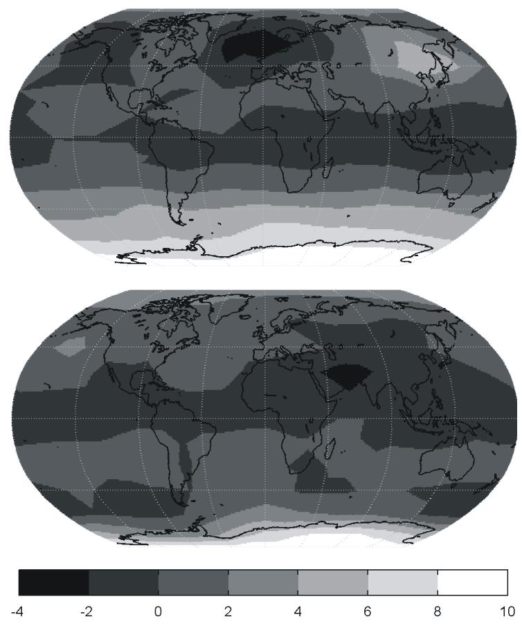
5 The most accurate computation of azimuthally symmetric mapping functions is assumed to be obtained from vertical profiles of temperature, pressure, and humidity from radiosondes [Niell et al., 2001]. The mapping function is then computed as the ratio of the delay (obtained by raytracing) along the path at the desired elevation to the delay in the zenith direction. For convenience we compare the mapping functions for a vacuum (outgoing) elevation angle of 5. The radiosonde data used for this comparison are from 23 sites and span the latitude range from -66 to +75. However, it has to be mentioned that the majority of the radiosonde sites are in the northern hemisphere. A 'rule of thumb' [MacMillan and Ma, 1994] states that for azimuthally symmetric delay errors and observations down to approximately 5, the height error is approximately one fifth of the delay error at the lowest elevation. The mapping function differences have been converted to an equivalent height difference using this rule of thumb because station height changes are more easily visualized than differences in the a coefficients. The mean station height differences, averaged over the year, are shown in Figure 1 after comparing the hydrostatic delays from NMF, GMF, and VMF1 with radiosonde data. The most important feature is the significantly smaller bias for hydrostatic GMF compared to hydrostatic NMF, thus confirming that the mean biases can be reduced with GMF. On the other hand, GMF and NMF are not significantly different with respect to the standard deviations of the height changes (not shown here) since both contain only annual time variability, whereas the actual variations occur on weekly, daily, and sub-daily time scales. The influence of the wet mapping functions is less critical than the hydrostatic component in GPS and VLBI analyses, since the wet delays are typically smaller than the hydrostatic delays by a factor of NMF and GMF compared to VMF1 in GPS analysis A global network of more than 100 GPS stations was analysed with the software package GAMIT Version [King and Bock, 2005; Herring, 2005] applying the NMF, GMF, and VMF1 mapping functions. We processed observations from July 2004 through June 2005, producing a fiducial-free global network for each day. The elevation cutoff angle was set to 7 and no downweighting of low observations was applied to make the performance of the mapping functions most visible. Atmospheric pressure loading (tidal and non-tidal) [Tregoning and van Dam, 2005] was applied along with ocean tide loading and the IERS2003 solid Earth tide model [IERS Conventions 2003]. We estimated satellite orbital
6 parameters, station coordinates, zenith tropospheric delay parameters every 2 hours, and resolved ambiguities where possible. We used ~60 sites to transform the fiducial-free networks into the ITRF2000 by estimating 6-parameter transformations (3 rotations, 3 translations) [Herring 2005]. For the investigations described below the time series were used of those 133 stations which have more than 300 daily height estimates. The latitudes of the sites are indicated in Figure 2 which shows the mean changes of GPS station heights with NMF or GMF relative to using VMF1. It is evident that the agreement between VMF1 and GMF is very good, whereas station height differences up to 10 mm occur in the southern hemisphere south of 45 S and in the Japan region when changing from VMF1 to NMF. 4.3 NMF versus GMF Computing hydrostatic GMF and NMF for each month on a global grid and applying the rule of thumb, we derived corresponding station height differences. In Figure 3 the height changes from NMF to GMF are plotted for January and July. These comparisons show that there is pretty good agreement between NMF and GMF in July (apart from Antarctica), but that in January differences are large (up to 15 mm) south of 45 S and in northeast China and Japan. These height changes vary throughout the year and influence other parameters such as scale and geocenter motion. In Figure 4 the three hydrostatic mapping functions discussed in this paper at 5 elevation are plotted for Fortaleza, Brazil. The NMF does not show a seasonal variation because this station is situated near the equator (2 S). In contrast, the GMF reflects a seasonal variability and, on average, agrees much better with the VMF1. However, a deficiency is evident in both empirical mapping functions compared to the VMF1 because neither NMF nor GMF reveal the unusual meteorological conditions described by the VMF1 during the El Niño phenomena in 1997 and Conclusions To achieve the highest accuracy in VLBI and GPS analyses, it is recommended to use troposphere mapping functions that are based on data from numerical weather models. Today, these mapping functions (e.g. VMF1 [Boehm et al., 2006] or IMF [Niell, 2001]) are available as time series of coefficients with a resolution of six hours. However, for
7 particular time periods or stations where NWM-based mapping functions are not available, the GMF can be used without introducing systematic biases in the coordinate time series, although the short-term precision will suffer compared to the VMF1. The GMF can serve as a 'back-up' mapping function or a compatible empirical representation of the more complex NWM-based mapping functions. The GMF provides better precision than the NMF and smaller height biases with respect to VMF1. It can be implemented very easily because it uses the same input parameters (station coordinates and day of year) as NMF, which is already implemented in most space geodesy software packages. Code for FORTRAN implementations of VMF1 and GMF are provided at as are the input data for VMF1 and IMF. Acknowledgments We would like to thank the Zentralanstalt fuer Meteorologie und Geodynamik (ZAMG) for allowing us access to the data of the European Centre for Medium-Range Weather Forecasts (ECMWF). Johannes Boehm and Harald Schuh are grateful to the Austrian Science Fund (FWF) for supporting this work under project P16992-N10. Arthur Niell was supported by NASA contract NNG05HY03C. The GPS analyses were computed on the Terrawulf linux cluster belonging to the Centre for Advanced Data Inference at the Research School of Earth Sciences, The Australian National University. References Boehm J., and H. Schuh (2004), Vienna Mapping Functions in VLBI analyses, Geophys. Res. Lett. 31(1):L01603, DOI: /2003GL Boehm J., B. Werl, and H. Schuh (2006), Troposphere mapping functions for GPS and VLBI from ECMWF operational analysis data, Journal of Geophysical Research, in press. Herring, T.A. (2005), GLOBK Global Kalman Filter VLBI and GPS analysis program, version 10.1, Mass. Inst. of Technol., Cambridge, MA. King, R.W., and Y. Bock (2005), Documentation for the GAMIT GPS processing software Release 10.2, Mass. Inst. of Technol., Cambridge, MA.
8 MacMillan, D.S., and C. Ma (1994), Evaluation of very long baseline interferometry atmospheric modeling improvements, J. Geophys. Res., 99, B1, pp McCarthy, D.D., and G. Petit (2004). IERS Conventions (2003), IERS Technical Note, No. 32, Verlag des Bundesamtes für Kartographie und Geodäsie, Frankfurt am Main. Niell, A.E. (1996), Global mapping functions for the atmosphere delay at radio wavelengths, J. Geophys. Res. 101(B2): Niell, A. E. (2001), Preliminary evaluation of atmospheric mapping functions based on numerical weather models, Phys. Chem. Earth, 26, Niell A.E., A.J. Coster, F.S. Solheim, V.B. Mendes, P.C. Toor, R.B. Langley, C.A. Upham (2001), Comparison of Measurements of Atmospheric Wet Delay by Radiosonde, Water Vapor Radiometer, GPS, and VLBI, Journal of Atmospheric and Oceanic Technology 18: Tregoning, P., and T. van Dam (2005), Atmospheric pressure loading corrections applied to GPS data at the observation level, Geophys. Res. Lett., 32, L22310, doi: /2005gl
9 Figure Captions: Figure 1: Mean height differences in mm for hydrostatic NMF ( relative to radiosonde based mapping functions for ), GMF (+), and VMF1 (o) Figure 2: Mean height changes in mm when using NMF ( with heights obtained with VMF1 as reference. ) and GMF (+) in GPS analysis Figure 3: Mean height changes (in mm) when using the hydrostatic GMF instead of NMF for January (upper plot) and July (lower plot) determined by applying the rule of thumb. The largest differences can be found in January south of 45 S and in northeast China and Japan, with station height differences up to 10 mm. Figure 4: Hydrostatic mapping function at 5 elevation at Fortaleza, Brazil. Phenomena such as the El Niño event in 1997 and 1998 cannot be accounted for with empirical mapping functions like NMF or GMF that contain only average seasonal terms.
10 height change in mm w.r.t. radiosonde latitude
11 6 height change in mm w.r.t. VMF latitude
12
13 VMF1 NMF GMF
Global Mapping Function (GMF): A new empirical mapping function based on numerical weather model data
: A new empirical mapping function based on numerical weather model data") Johannes Böhm, Arthur Niell, Paul Tregoning, and Harald Schuh Global Mapping Function (GMF): A new empirical mapping function based on numerical weather model data Geophysical Research Letters Vol. 33,
Johannes Böhm, Arthur Niell, Paul Tregoning, and Harald Schuh Global Mapping Function (GMF): A new empirical mapping function based on numerical weather model data Geophysical Research Letters Vol. 33,
Analysis of the Accuracy of GMF, NMF, and VMF1 Mapping Functions with GPT 50 a Priori Zenith Constraint in Tropospheric Delay Modelling
 Analysis of the Accuracy of GMF, NMF, and VMF1 Mapping Functions with GPT 50 a Priori Zenith Constraint in Tropospheric Delay Modelling Brian Makabayi 1 Addisu Hunegnaw 2 1 Assistant Lecturer, Department
Impact of A Priori Gradients on VLBI-Derived Terrestrial Reference Frames
 Impact of A Priori Gradients on VLBI-Derived Terrestrial Reference Frames J. Böhm, H. Spicakova, L. Urquhart, P. Steigenberger, H. Schuh Abstract We compare the influence of two different a priori gradient
Impact of A Priori Gradients on VLBI-Derived Terrestrial Reference Frames
 Impact of A Priori Gradients on VLBI-Derived Terrestrial Reference Frames J. Böhm, H. Spicakova, L. Urquhart, P. Steigenberger, H. Schuh Abstract We compare the influence of two different a priori gradient
Impact of a priori zenith hydrostatic delay errors on GPS estimates of station heights and zenith total delays
 Click Here for Full Article GEOPHYSICAL RESEARCH LETTERS, VOL. 33, L23303, doi:10.1029/2006gl027706, 2006 Impact of a priori zenith hydrostatic delay errors on GPS estimates of station heights and zenith
Johannes Böhm, Robert Heinkelmann, and Harald Schuh. Short Note: A Global Model of Pressure and Temperature for Geodetic Applications
 Johannes Böhm, Robert Heinkelmann, and Harald Schuh Short Note: A Global Model of Pressure and Temperature for Geodetic Applications Journal of Geodesy doi:10.1007/s00190-007-0135-3 2007a Short Note: A
GPT2: Empirical slant delay model for radio space geodetic techniques
 GEOPHYSICAL RESEARCH LETTERS, VOL. 40, 1069 1073, doi:10.1002/grl.50288, 2013 GPT2: Empirical slant delay model for radio space geodetic techniques K. Lagler, 1,2 M. Schindelegger, 1 J. Böhm, 1 H. Krásná,
Atmospheric Effects in Space Geodesy
 Atmospheric Effects in Space Geodesy Johannes Böhm 18 November 2011 @ UNESP, Presidente Prudente, Brazil The atmosphere.. is not only causing troubles in space geodesy.. but it opens up a wide field of
ESTIMATING THE RESIDUAL TROPOSPHERIC DELAY FOR AIRBORNE DIFFERENTIAL GPS POSITIONING (A SUMMARY)
") ESTIMATING THE RESIDUAL TROPOSPHERIC DELAY FOR AIRBORNE DIFFERENTIAL GPS POSITIONING (A SUMMARY) J. Paul Collins and Richard B. Langley Geodetic Research Laboratory Department of Geodesy and Geomatics
ESTIMATING THE RESIDUAL TROPOSPHERIC DELAY FOR AIRBORNE DIFFERENTIAL GPS POSITIONING (A SUMMARY) J. Paul Collins and Richard B. Langley Geodetic Research Laboratory Department of Geodesy and Geomatics
Very Long Baseline Interferometry for Geodesy and Astrometry
 Very Long Baseline Interferometry for Geodesy and Astrometry Johannes Böhm Harald Schuh and Johannes Böhm, Very Long Baseline Interferometry for Geodesy and Astrometry, in Guochang Xu (editor): Sciences
Introduction to geodetic VLBI
 Introduction to geodetic VLBI David Mayer Andreas Hellerschmied Johannes Böhm Harald Schuh and Johannes Böhm, Very Long Baseline Interferometry for Geodesy and Astrometry, in Guochang Xu (editor): Sciences
LONG-TERM TRENDS IN THE AMOUNT OF ATMOSPHERIC WATER VAPOUR DERIVED FROM SPACE GEODETIC AND REMOTE SENSING TECHNIQUES
 LONG-TERM TRENDS IN THE AMOUNT OF ATMOSPHERIC WATER VAPOUR DERIVED FROM SPACE GEODETIC AND REMOTE SENSING TECHNIQUES Rüdiger Haas, Tong Ning, and Gunnar Elgered Chalmers University of Technology, Onsala
REFINED AND SITE-AUGMENTED TROPOSPHERIC DELAY MODELS FOR GNSS
 REFINED AND SITE-AUGMENTED TROPOSPHERIC DELAY MODELS FOR GNSS Daniel Landskron, Gregor Möller, Armin Hofmeister, Johannes Böhm, and Robert Weber Technische Universität Wien, Austria Gußhausstraße 27-29,
Humidity 3D field comparisons between GNSS tomography, IASI satellite observations and ALARO model. Belgian Institute for Space Aeronomy BIRA 3
 Oral Presentation, EGU0-85 Humidity D field comparisons between, H. Brenot, C. Champollion, A. Deckmyn, R. van Malderen, N. Kumps, R. Warnant, E. Goudenhoofdt, L. Delobbe and M. De Mazière contact: Belgian
Modeling and Observation of Loading Contribution to Time-Variable GPS Site Positions
 EGU2009-3768 Session G4 EGU General Assembly 2009 Vienna, Austria, 19 24 April 2009 Modeling and Observation of Loading Contribution to Time-Variable GPS Site Positions Are we able to Detect and Identify
Principles of Global Positioning Systems Spring 2008
 MIT OpenCourseWare http://ocw.mit.edu 12.540 Principles of Global Positioning Systems Spring 2008 For information about citing these materials or our Terms of Use, visit: http://ocw.mit.edu/terms. 12.540
State-of-the-art physical models for calculating atmospheric pressure loading effects
 State-of-the-art physical models for calculating atmospheric pressure loading effects Dudy D. Wijaya, Böhm J., Schindelegger M., Karbon M., Schuh H. Institute of Geodesy and Geophysics, TU Vienna Geodätische
Modeling and Observation of Loading Contribution to Time-Variable GPS Site Positions
 EGU2009-3768 Session G4 EGU General Assembly 2009 Vienna, Austria, 19 24 April 2009 Modeling and Observation of Loading Contribution to Time-Variable GPS Site Positions Are we able to Detect and Identify
Workshop on Numerical Weather Models for Space Geodesy Positioning
 Workshop on Numerical Weather Models for Space Geodesy Positioning Marcelo C. Santos University of New Brunswick, Department of Geodesy and Geomatics Engineering, Fredericton, NB Room C25 (ADI Room), Head
Correction to Atmospheric Effects and Spurious Signals in GPS Analyses
 JOURNAL OF GEOPHYSICAL RESEARCH, VOL.???, XXXX, DOI:10.1029/, 1 2 Correction to Atmospheric Effects and Spurious Signals in GPS Analyses P. Tregoning 3 4 Research School of Earth Sciences, The Australian
High Rate GPS Solutions
 High Rate GPS Solutions High rate GPS data (1 Hz or higher) Network solution Fixed a local reference clock Bias fixed Sub daily position estimates solutions Position becomes stochastic parameter Fairly
Impact of Tropospheric Delay Gradients on Total Tropospheric Delay and Precise Point Positioning
 International Journal of Geosciences, 016, 7, 645-654 Published Online May 016 in SciRes. http://www.scirp.org/journal/ijg http://dx.doi.org/10.436/ijg.016.75050 Impact of Tropospheric Delay Gradients
ESTIMATION OF NUTATION TERMS USING GPS
 ESTIMATION OF NUTATION TERMS USING GPS Markus Rothacher, Gerhard Beutler Astronomical Institute, University of Berne CH-3012 Berne, Switzerland ABSTRACT Satellite space-geodetic measurements have been
A priori gradients in the analysis of GPS and VLBI observations
 A priori gradients in the analysis of GPS and VLBI observations Peter Steigenberger GeoForschungsZentrum Potsdam Volker Tesmer Deutsche Geodätisches Forschungsinstitut, München Johannes Boehm Institute
SCIENCE CHINA Earth Sciences. A global empirical model for estimating zenith tropospheric delay
 SCIENCE CHINA Earth Sciences RESEARCH PAPER January 2016 Vol.59 No.1: 118 128 doi: 10.1007/s11430-015-5173-8 A global empirical model for estimating zenith tropospheric delay YAO YiBin 1,2*, ZHANG Bao
Very Long Baseline Interferometry for Geodesy and Astrometry
 VieVS User-Workshop 2017 Very Long Baseline Interferometry for Geodesy and Astrometry Johannes Böhm VLBI How does it work? VLBI a flowchart SINEX skd vex2 drudge drudge snp/prc snp/prc NGS Mark4 Mark4
Use of ground-based GNSS measurements in data assimilation. Reima Eresmaa Finnish Meteorological Institute
 Use of ground-based GNSS measurements in data assimilation Reima Eresmaa Finnish Meteorological Institute 16 June 2006 Outline 1) Introduction GNSS * positioning Tropospheric delay 2) GNSS as a meteorological
Earth gravity field recovery using GPS, GLONASS, and SLR satellites
 13-01-08 Earth gravity field recovery using GPS, GLONASS, and SLR satellites Krzysztof Sośnica (1), Adrian Jäggi (1), Daniela Thaller (2), Ulrich Meyer (1), Christian Baumann (1), Rolf Dach (1), Gerhard
The PaTrop Experiment
 Improved estimation of the tropospheric delay component in GNSS and InSAR measurements in the Western Corinth Gulf (Greece), by the use of a highresolution meteorological model: The PaTrop Experiment N.
ERAD Water vapor observations with SAR, microwave radiometer and GPS: comparison of scaling characteristics
 Proceedings of ERAD (2002): 190 194 c Copernicus GmbH 2002 ERAD 2002 Water vapor observations with SAR, microwave radiometer and GPS: comparison of scaling characteristics D. N. Moisseev 1, R. F. Hanssen
Towards an improved ILRS TRF contribution
 Towards an improved ILRS TRF contribution Erricos C. Pavlis ILRS Analysis Coordinator JCET/ & NASA Goddard IERS Workshop on Conventions 2007 20-21 Sept. 2007, Sèvres, France Overview The ILRS Network Geometry
Effect of troposphere slant delays on regional double difference GPS processing
 Earth Planets Space, 61, 845 852, 2009 Effect of troposphere slant delays on regional double difference GPS processing Maaria Nordman 1, Reima Eresmaa 2, Johannes Boehm 3, Markku Poutanen 1, Hannu Koivula
Using Numerical Weather Prediction Model Derived Tropospheric Slant Delays in GPS Processing: a Case Study
 Geophysica (2007), 43(1 2), 49 57 Using Numerical Weather Prediction Model Derived Tropospheric Slant Delays in GPS Processing: a Case Study Maaria Nordman 1, Reima Eresmaa 2, Markku Poutanen 1, Heikki
GNSS-specific local effects at the Geodetic Observatory Wettzell
 GNSS-specific local effects at the Geodetic Observatory Wettzell Peter Steigenberger, Urs Hugentobler, Ralf Schmid Technische Universität München (TUM) Uwe Hessels, Thomas Klügel Bundesamt für Kartographie
Summary of the 2012 Global Geophysical Fluid Center Workshop
 Summary of the 2012 Global Geophysical Fluid Center Workshop T. van Dam (Uni. Lux), J. Ray (NGS/NOAA), X. Collilieux (IGN) Introduction Review the history of the GGFC Discuss the 2012 Workshop Review recommendations
Call for space geodetic solutions corrected for non-tidal atmospheric loading (NT-ATML) at the observation level
 at the observation level") Call for space geodetic solutions corrected for non-tidal atmospheric loading (NT-ATML) at the observation level Xavier Collilieux, Tonie van Dam, Zuheir Altamimi Outline: Context Why correcting for non-tidal
Call for space geodetic solutions corrected for non-tidal atmospheric loading (NT-ATML) at the observation level Xavier Collilieux, Tonie van Dam, Zuheir Altamimi Outline: Context Why correcting for non-tidal
Challenges and Perspectives for TRF and CRF Determination
 , IVS 2012 General Meeting Proceedings, p.309 313 http://ivscc.gsfc.nasa.gov/publications/gm2012/boehm.pdf Johannes Böhm 1, Zinovy Malkin 2, Sebastien Lambert 3, Chopo Ma 4 1) Vienna University of Technology
UNB Neutral Atmosphere Models: Development and Performance
 UNB Neutral Atmosphere Models: Development and Performance Rodrigo Leandro, Marcelo Santos, and Richard B. Langley Geodetic Research Laboratory, Department of Geodesy and Geomatics Engineering University
Using non-tidal atmospheric loading model in space geodetic data processing: Preliminary results of the IERS analysis campaign
 Using non-tidal atmospheric loading model in space geodetic data processing: Preliminary results of the IERS analysis campaign Xavier Collilieux (1), Zuheir Altamimi (1), Laurent Métivier (1), Tonie van
OPTIMIZATION OF TROPOSPHERIC DELAY MAPPING FUNCTION PERFORMANCE FOR HIGH-PRECISION GEODETIC APPLICATIONS
 OPTIMIZATION OF TROPOSPHERIC DELAY MAPPING FUNCTION PERFORMANCE FOR HIGH-PRECISION GEODETIC APPLICATIONS Virgílio B. MENDES 1, and Richard B. LANGLEY 1 Faculty of Sciences of the University of Lisbon,
Improving the long-term stability of the GDR orbit solutions
 Improving the long-term stability of the GDR orbit solutions L. Cerri 1, A. Couhert 1, S. Houry 1, F. Mercier 1 (1) CNES Toulouse OSTST Meeting 19-21 Oct. 2011 POD Splinter Session Status of the POD standards
OBSERVING AND MODELING LONG-PERIOD TIDAL VARIATIONS IN POLAR MOTION
 OBSERVING AND MODELING LONG-PERIOD TIDAL VARIATIONS IN POLAR MOTION R.S. GROSS 1, S.R. DICKMAN 2 1 Jet Propulsion Laboratory, California Institute of Technology 4800 Oak Grove Drive, Pasadena, CA 91109,
Péter Braunmüller: The evaluation of troposphere models applied in the Hungarian Active GNSS Network
 Péter Braunmüller: The evaluation of troposphere models applied in the Hungarian Active GNSS Network Abridged version of my MSc degree thesis at the Budapest University of Technology and Economics written
Characteristics of GPS ZTD products. Jan Douša EUREF Analysis Centre Workshop
 Characteristics of GPS ZTD products Jan Douša EUREF Analysis Centre Workshop March 15-16, 2006 Outline ZTD and PWV products Stragegy changes GPS constellation effect solution characteristics ZTD differences
Three-dimensional distribution of water vapor estimated from tropospheric delay of GPS data in a mesoscale precipitation system of the Baiu front
 Earth Planets Space, 52, 927 933, 2000 Three-dimensional distribution of water vapor estimated from tropospheric delay of GPS data in a mesoscale precipitation system of the Baiu front Hiromu Seko 1, Seiichi
Estimation of Geodetic and Geodynamical Parameters with VieVS
 Estimation of Geodetic and Geodynamical Parameters with VieVS, IVS 2010 General Meeting Proceedings, p.202 206 http://ivscc.gsfc.nasa.gov/publications/gm2010/spicakova.pdf Estimation of Geodetic and Geodynamical
SCIENCE CHINA Physics, Mechanics & Astronomy. Establishment of a new tropospheric delay correction model over China area
 SCIENCE CHINA Physics, Mechanics & Astronomy Research Paper December 2011 Vol.54 No.12: 2271 2283 doi: 10.1007/s11433-011-4530-7 Establishment of a new tropospheric delay correction model over China area
Global reference systems and Earth rotation
 current realizations and scientific problems Aleksander Brzeziński 1,2, Tomasz Liwosz 1, Jerzy Rogowski 1, Jan Kryński 3 1 Department of Geodesy and Geodetic Astronomy Warsaw University of Technology 2
Earth gravity field recovery using GPS, GLONASS, and SLR satellites
 Earth gravity field recovery using GPS, GLONASS, and SLR satellites Krzysztof Sośnica (1), Adrian Jäggi (1), Daniela Thaller (2), Ulrich Meyer (1), Gerhard Beutler (1), Rolf Dach (1) (1) Astronomical Institute,
Measurement of Water Vapor by GPS, WVR, and Radiosonde
 Measurement of Water Vapor by GPS, WVR, and Radiosonde A.E. Niell 1, A.J. Coster 2, F.S. Solheim 3, V.B. Mendes 4, P.C. Toor 4 R.B. Langley 4 C.A. Ruggles 2 1 MIT Haystack Observatory, Westford, MA 01886
GNSS and the Troposphere
 GNSS and the Troposphere Jan Johansson jan.johansson@chalmers.se Onsala Space Observatory Chalmers University of Technology Gothenburg, Sweden Department of Space and Earth Sciences 1 Onsala Space Observatory
Lecture 2 Measurement Systems. GEOS 655 Tectonic Geodesy
 Lecture 2 Measurement Systems GEOS 655 Tectonic Geodesy VLBI and SLR VLBI Very Long Baseline Interferometry SLR Satellite Laser Ranging Very Long Baseline Interferometry VLBI Geometric Delay δg S Baseline
Multi-Technique Comparisons of Ten Years of Wet Delay Estimates on the West Coast of Sweden
 Noname manuscript No. (will be inserted by the editor) 1 2 Multi-Technique Comparisons of Ten Years of Wet Delay Estimates on the West Coast of Sweden 3 T. Ning R. Haas G. Elgered U. Willén 4 5 the date
INTERNATIONAL SLR SERVICE
 ARTIFICIAL SATELLITES, Vol. 46, No. 4 2011 DOI: 10.2478/v10018-012-0004-z INTERNATIONAL SLR SERVICE Stanisław Schillak Space Research Centre, Polish Academy of Sciences Astrogeodynamic Observatory, Borowiec
Past, present and possible updates to the IERS Conventions. J. Ray, NGS G. Petit, BIPM
 Past, present and possible updates to the IERS Conventions J. Ray, NGS G. Petit, BIPM IERS Conventions update: electronic access http://tai.bipm.org/iers/convupdt/listupdt.html Introduction Add a set of
Validation of Climate Models Using Ground-Based GNSS Observations. Dep. of Earth and Space Sciences, Onsala Space Observatory, SE Onsala
 Validation of Climate Models Using Ground-Based GNSS Observations Gunnar Elgered 1, Jan Johansson 1,2, Erik Kjellström 3, Ragne Emardson 2, Per Jarlemark 2, Tobias Nilsson 1,4, Tong Ning 1, Ulrika Willén
Impact of Earth Radiation Pressure on LAGEOS Orbits and on the Global Scale
 13-Po-22 Impact of Earth Radiation Pressure on LAGEOS Orbits and on the Global Scale Krzysztof Sośnica (1), Carlos Javier Rodríguez-Solano (2), Daniela Thaller (3), Adrian Jäggi (1), Rolf Dach (1), Gerhard
GGOS Bureau for Standards and Conventions
 GGOS D. Angermann (1), T. Gruber (2), J. Bouman (1), M. Gerstl (1), R. Heinkelmann (1), U. Hugentobler (2), L. Sánchez (1), P. Steigenberger (2) (1) Deutsches Geodätisches Forschungsinstitut (DGFI), München
Dynamic statistical optimization of GNSS radio occultation bending angles: an advanced algorithm and performance analysis results
 Dynamic statistical optimization of GNSS radio occultation bending angles: an advanced algorithm and performance analysis results Ying Li 1,2, Gottfried Kirchengast 3,2, Barbara Scherllin-Pirscher 3, Robert
Atmospheric Water Vapor and Geoid Measurements in the Open Ocean with GPS
 Atmospheric Water Vapor and Geoid Measurements in the Open Ocean with GPS Christian Rocken, James Johnson, Teresa Van Hove, Tetsuya Iwabuchi COSMIC Program Office, University Corporation for Atmospheric
Principles of the Global Positioning System Lecture 18" Mathematical models in GPS" Mathematical models used in GPS"
 12.540 Principles of the Global Positioning System Lecture 18" Prof. Thomas Herring" Room 54-820A; 253-5941" tah@mit.edu" http://geoweb.mit.edu/~tah/12.540 " Mathematical models in GPS" Review assignment
Relationships between mass redistribution, station position, geocenter, and Earth rotation: Results from IGS GNAAC analysis
 Relationships between mass redistribution, station position, geocenter, and Earth rotation: Results from IGS GNAAC analysis Geoff Blewitt Mackay School of Earth Sciences and Engineering University of Nevada,
Christina Selle, Shailen Desai IGS Workshop 2016, Sydney
 Optimization of tropospheric delay estimation parameters by comparison of GPS-based precipitable water vapor estimates with microwave radiometer measurements Christina Selle, Shailen Desai IGS Workshop
GINS: a new tool for VLBI Geodesy and Astrometry
 GINS: a new tool for VLBI Geodesy and Astrometry G. Bourda, P. Charlot, R. Biancale 2 () Observatoire Aquitain des Sciences de l Univers - Université Bordeaux I Laboratoire d Astrophysique de Bordeaux
Numerical Experiment on Atmospheric Delay in Very Long Baseline Interferometric Observation*
 Journal of the Geodetic Society of Japan Vol. 29, No. 4, (1983), pp. 262-272 Numerical Experiment on Atmospheric Delay in Very Long Baseline Interferometric Observation* Masaru KAIDZU Geographical Survey
The global S 1 tide and Earth s nutation
 Journées 2014 St. Petersburg 22 24 September Michael SCHINDELEGGER Johannes BÖHM, David SALSTEIN The global S 1 tide and Earth s nutation Session 4: Earth s rotation and geodynamics Motivation & Background
Originally published as:
 Originally published as: Seitz M., Steigenberger P., Artz T. (2xx) Consistent adjustment of combined terrestrial and celestial reference frames, Earth on the Edge: Science for a Sustainable Planet, IAG
Effect of post-seismic deformation on earth orientation parameter estimates from VLBI observations: a case study at Gilcreek, Alaska
 J Geod (2005) DOI 10.1007/s00190-005-0459-9 ORIGINAL ARTICLE O. Titov P. Tregoning Effect of post-seismic deformation on earth orientation parameter estimates from VLBI observations: a case study at Gilcreek,
arxiv:physics/ v1 [physics.geo-ph] 29 Jul 2004
![arxiv:physics/ v1 [physics.geo-ph] 29 Jul 2004](/thumbs/94/119448888.jpg "arxiv:physics/ v1 [physics.geo-ph] 29 Jul 2004") Computation of a homogeneous coordinate time series for European GPS stations by reprocessing of the weekly EPN solutions arxiv:physics/713v1 [physics.geo-ph] 9 Jul Natalia Panafidina, Zinovy Malkin Institute
Computation of a homogeneous coordinate time series for European GPS stations by reprocessing of the weekly EPN solutions arxiv:physics/713v1 [physics.geo-ph] 9 Jul Natalia Panafidina, Zinovy Malkin Institute
Evaluation of the impact of atmospheric pressure loading modeling on GNSS data analysis
 Evaluation of the impact of atmospheric pressure loading modeling on GNSS data analysis R. Dach a, J. Böhm b, S. Lutz a, and P. Steigenberger c a Astronomical Institute, University of Bern, Bern, Switzerland
Journal of Atmospheric and Solar-Terrestrial Physics
 Journal of Atmospheric and Solar-Terrestrial Physics 7 (8) 1366 137 Contents lists available at ScienceDirect Journal of Atmospheric and Solar-Terrestrial Physics journal homepage: www.elsevier.com/locate/jastp
A new global zenith tropospheric delay model IGGtrop for GNSS applications
 Article Geophysics June 2012 Vol.57 No.17: 21322139 doi: 10.1007/s11434-012-5010-9 SPECIAL TOPICS: A new global zenith tropospheric delay model IGGtrop for GNSS applications LI Wei 1*, YUAN YunBin 1, OU
Twin Telescopes at Onsala and Wettzell and their contribution to the VGOS System
 Twin Telescopes at Onsala and Wettzell and their contribution to the VGOS System C. Schönberger, P. Gnilsen, J. Böhm, R. Haas Abstract During the last years the International VLBI Service for Geodesy and
The 2008 Local-tie Survey at the Onsala Space Observatory
 The 2008 Local-tie Survey at the Onsala Space Observatory M. Lösler, Geodetic Institute of the University of Karlsruhe (TH), DE-76128 Karlsruhe, Germany R. Haas Department of Radio and Space Science, Chalmers
FEASIBILITY OF DIRECTLY MEASURING SINGLE LINE-OF-SIGHT GPS SIGNAL DELAYS
 FEASIBILITY OF DIRECTLY MEASURING SINGLE LINE-OF-SIGHT GPS SIGNAL DELAYS Pedro Elosegui and James L. Davis Smithsonian Astrophysical Observatory Cambridge, MA 13, USA January, 3 1 1. Executive Summary
Connecting terrestrial to celestial reference frames
 Russian Academy of Sciences Central Astronomical Observatory at Pulkovo IAU XXVIII General Assembly, Joint Discussion 7, Beijing, China, August 28, 2012 Connecting terrestrial to celestial reference frames
Nutation determination by means of GNSS
 Nutation determination by means of GNSS - Comparison with VLBI Nicole Capitaine, Kunliang Yao SYRTE - Observatoire de Paris, CNRS/UPMC, France Introduction Space geodetic techniques cannot be used for
Fundamental Station Wettzell - geodetic observatory -
 Fundamental Station Wettzell - geodetic observatory - Wolfgang Schlüter Bundesamt für Kartographie und Geodäsie, Fundamental Station Wettzell Germany Radiometer Workshop, Wettzell, 10.10.06 Evolvement
Precipitable water observed by ground-based GPS receivers and microwave radiometry
 Earth Planets Space, 52, 445 450, 2000 Precipitable water observed by ground-based GPS receivers and microwave radiometry Yuei-An Liou, Cheng-Yung Huang, and Yu-Tun Teng Center for Space and Remote Sensing
On the use of meteo data. How to raise the value of EPN s
 On the use of meteo data or How to raise the value of EPN s ZTD product? Jan Dousa & Wolfgang Söhne 50th EUREF TWG, Florence, 2009-05-26 Introduction Last TWG (Jan Dousa's presentation): ti Towards more
Troposphere delays from space geodetic techniques, fwater vapor radiometers, and numerical weather models over a series of continuous VLBI campaigns
 Troposphere delays from space geodetic techniques, fwater vapor radiometers, and numerical weather models over a series of continuous VLBI campaigns Kamil Teke (1, 2), Tobias Nilsson (3), Johannes Böhm
The Effect of Gradients in the GPS Estimation of Tropospheric Water Vapor
 The Effect of Gradients in the GPS Estimation of Tropospheric Water Vapor A. J. Coster 1, A.E.Niell 2, F.S.Solheim 3, V.B. Mendes 4, P.C. Toor 4, R. B. Langley 4, 1 MIT Lincoln Laboratory, Millstone Radar,
Application of Satellite Laser Ranging for Long- Wavelength Gravity Field Determination
 Application of Satellite Laser Ranging for Long- Wavelength Gravity Field Determination J. C. Ries Center for Space Research The University of Texas at Austin Low Degree Gravity Variations from SLR GRACE
Analysis Strategies And Software For Geodetic VLBI
 Analysis Strategies And Software For Geodetic VLBI Rüdiger Haas Presentation at the 7th EVN Symposium, Toledo, 2004 Outline: Observing stategies and observables Data analysis strategies Data analysis software
Precise Point Positioning requires consistent global products
 Precise Point Positioning requires consistent global products H. P. Kierulf Hans-Peter Plag Abstract Precise Point Positioning (PPP) is increasingly used to compute time series of point motion in a global
Towards a Consistent Conventional Treatment of Surface-Load Induced Deformations
 Towards a Consistent Conventional Treatment of Surface-Load Induced Deformations Hans-Peter Plag(1), Geoff Blewitt, Tom A. Herring (1) Nevada Bureau of Mines and Geology and Seismological Laboratory University
Study the Effect of New Egypt Wet Mapping Function on Space Geodetic Measurements
 American Journal of Remote Sensing 2018; 6(1): 29-38 http://www.sciencepublishinggroup.com/j/ajrs doi: 10.11648/j.ajrs.20180601.16 ISSN: 2328-5788 (Print); ISSN: 2328-580X (Online) Study the Effect of
ATMOSPHERIC AND OCEANIC EXCITATION OF EARTH ROTATION
 ATMOSPHERIC AND OCEANIC EXCITATION OF EARTH ROTATION S. BÖHM, T. NILSSON, M. SCHINDELEGGER, H. SCHUH Institute of Geodesy and Geophysics, Advanced Geodesy Vienna University of Technology Gußhausstraße
Observed Trends in Wind Speed over the Southern Ocean
 GEOPHYSICAL RESEARCH LETTERS, VOL. 39,, doi:10.1029/2012gl051734, 2012 Observed s in over the Southern Ocean L. B. Hande, 1 S. T. Siems, 1 and M. J. Manton 1 Received 19 March 2012; revised 8 May 2012;
We have processed RO data for climate research and for validation of weather data since 1995 as illustrated in Figure 1.
 Real-time Analysis of COSMIC Data Christian Rocken, Doug Hunt, Bill Schreiner University Corporation for Atmospheric Research (UCAR) COSMIC Project Office Boulder, CO Abstract UCAR has analyzed GPS radio
GRACE Gravity Model GGM02
 GRACE Gravity Model GGM02 The GGM02S gravity model was estimated with 363 days (spanning April 2002 through December 2003) of GRACE K-band range-rate, attitude, and accelerometer data. No Kaula constraint,
Lake parameters climatology for cold start runs (lake initialization) in the ECMWF forecast system
 in the ECMWF forecast system") 2nd Workshop on Parameterization of Lakes in Numerical Weather Prediction and Climate Modelling Lake parameters climatology for cold start runs (lake initialization) in the ECMWF forecast system R. Salgado(1),
2nd Workshop on Parameterization of Lakes in Numerical Weather Prediction and Climate Modelling Lake parameters climatology for cold start runs (lake initialization) in the ECMWF forecast system R. Salgado(1),
The Second Realization of the International Celestial Reference Frame
 ICRF2 Highlights Work done by IERS/IVS and IAU Working Groups A truly international team Constructed using 30 Years of Very Long Baseline Interferometry data 4 times more observations than ICRF1 Improved
Impact of GPS and TMI Precipitable Water Data on Mesoscale Numerical Weather Prediction Model Forecasts
 Journal of the Meteorological Society of Japan, Vol. 82, No. 1B, pp. 453--457, 2004 453 Impact of GPS and TMI Precipitable Water Data on Mesoscale Numerical Weather Prediction Model Forecasts Ko KOIZUMI
Geodätische Woche The global radiational S1 tide - current Earth rotation research at TU Wien. September 17, 2015
 Geodätische Woche 2015 A. Girdiuk, M. Schindelegger, J. Böhm / TU Wien / Geodätische Woche 2015 1/14 - current Earth rotation research at TU Wien A. Girdiuk, M. Schindelegger, J. Böhm TU Wien, Geodesy
GPS Tomography and Remote Sensing Techniques for Water Vapor Determination in the ESCOMPTE Campaign
 GPS Tomography and Remote Sensing Techniques for Water Vapor Determination in the ESCOMPTE Campaign S. Lutz 1, M. Troller 1, A. Somieski 1, A. Walpersdorf 2, E. Doerflinger 3, A. Geiger 1, B. Bürki 1,
Common Realization of Terrestrial and Celestial Reference Frame
 Common Realization of Terrestrial and Celestial Reference Frame M. Seitz, R. Heinkelmann, P. Steigenberger, T. Artz Abstract The realization of the International Celestial Reference System (ICRS) and the
Tectonics of the terrestrial litosphere in spherical harmonics
 Journal of Physics: Conference Series PAPER OPEN ACCESS Tectonics of the terrestrial litosphere in spherical harmonics To cite this article: A V Mokhnatkin et al 2016 J. Phys.: Conf. Ser. 769 012007 View
The celestial reference system and its role in the epoch of global geodetic technologies
 Reports on Geodesy, vol. 92, no. 1, 2012 The celestial reference system and its role in the epoch of global geodetic technologies Jerzy B. Rogowski 1, Aleksander Brzeziński 1,2 1 Warsaw University of Technology,
THE FREE CORE NUTATION
 THE FREE CORE NUTATION D.D. MCCARTHY U. S. Naval Observatory Washington, DC 20392 USA e-mail: dmc@maia.usno.navy.mil ABSTRACT. The International Earth rotation and Reference system Service (IERS) provides