Analysis effects in IGS station motion time series P. Rebischung, X. Collilieux, T. van Dam, J. Ray, Z. Altamimi
|
|
|
- Lucy Hoover
- 6 years ago
- Views:
Transcription


1 Analysis effects in IGS station motion time series P. Rebischung, X. Collilieux, T. van Dam, J. Ray, Z. Altamimi IGS workshop 2012, Olsztyn, Poland 1
 Thermal expansion of ground and monuments Other local deformations Artificial variations due to, e.g., Mis-modeling(orbits, troposphere.")
2 Background: expectedsignals IGS station position time series mainly consist of: Trends + discontinuities Ex: YAR2 (Australia) height time series Seasonal variations, including: Displacements due to mass transfers at the Earth s surface (loading) Thermal expansion of ground and monuments Other local deformations Artificial variations due to, e.g., Mis-modeling(orbits, troposphere...) Observation data & data quality variations Local multipath variations 2
3 Background: GPS draconiticyear Period at which the GPS/sun orientation repeats Schmid et al., (2007) Detectedby Ray (2006) in IGS position time series Visible in nearlyall IGS products Possible origins: Aliasing of local site effects(multipath, antenna mis-calibration ) Orbiterrors(e.g. due to errorsin IERS subdailyerp tide model, Griffiths & Ray, 2011) 3
4 Outline Goal: Investigate systematic errors in IGS station positions 1) Load-corrected IGS combined station positions What is the contribution of draconitic errors? 2) Inter-AC discrepancies Are there systematic AC-specific analysis artifacts? How large are they compared to the IGS-load residuals? 4
5 IGS positions & loadingmodel: Data GPS position time series: (Special) combination of AC repro1/operational weekly SINEX solutions Time series segmentation Corrections for offsets, velocities& apparent geocenter motion Non-tidal loading model: Green s function approach Earth model: Gutenberg-Bullen Reference Frame: Center of Figure (CF) of the Earth (Blewitt, 2003) ECCO NCEP GLDAS version h 1 x 1 6 h 2,5 x 2,5 1 month 1 x 1 5
6 IGS positions & loadingmodel: Comparison Conclusions from Collilieux et al., 2011 and Ray et al., 2011: Load corrections reduce WRMS for most stations, even in horizontal. (Mostly due to reduction of annual signals.) Annual signal amplitudes (mm): Raw GPS Load-corrected GPS But most residual signal remains, especially in horizontal. Inaccuracy of loading models Thermal + local deformations GPS errors Draconitic errors must contribute to remaining annual signals, but magnitude is unknown. 6
7 Load-correctedIGS positions: annualor draconitic? Simultaneous estimation of annual& draconitic: Possible with long enough time series(beat period 25 years) cf. Watson et al., UGGI 2011& Haines et al., AGU 2011 But hypothesis of time-variable annual signal plausible as well. Draconitic amplitudes: load-corrected GPS series vs. raw GPS series (records longer than 3 years) Estimated draconitic signals seem reliable. 7
: Annual in raw GPS Annual in load-corrected GPS Annual & draconitic estimated simultaneously: Amplitudes (mm): Annual in load-corrected GPS Draconitic in")
8 Load-correctedIGS positions: annualor draconitic? Annual estimated alone: Amplitudes (mm): Annual in raw GPS Annual in load-corrected GPS Annual & draconitic estimated simultaneously: Amplitudes (mm): Annual in load-corrected GPS Draconitic in load-corrected GPS Simultaneous estimation of annual& draconitic does not significantly improve the agreement between GPS and loading models at the annual frequency. Residual annual& draconitic signals have similar magnitudes. 8


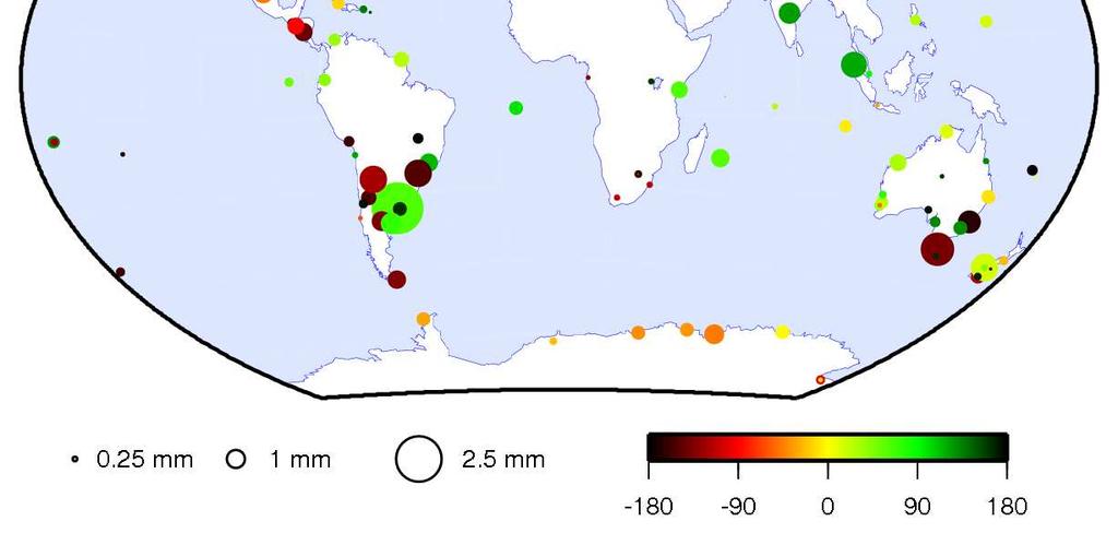
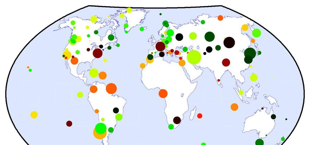
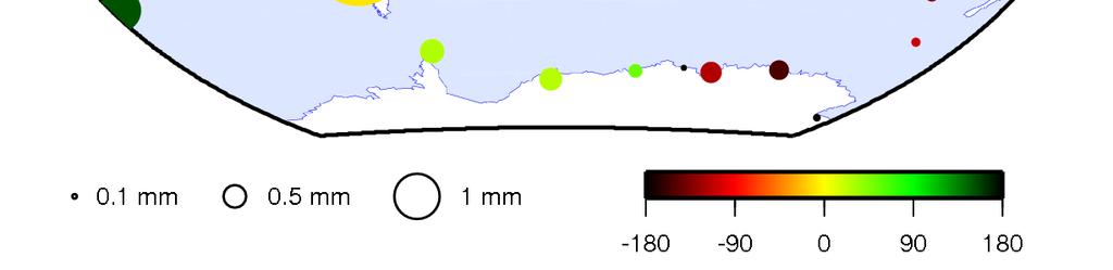
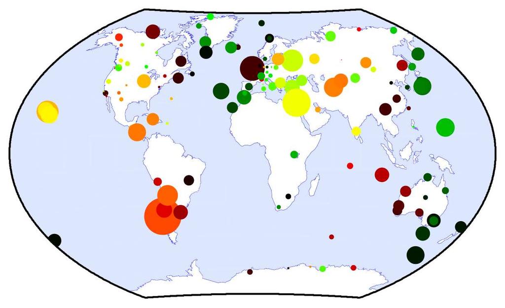
9 Load-correctedIGS positions: annual/draconitic Annual East Annual North Annual Up Draconitic East Draconitic North Draconitic Up 9


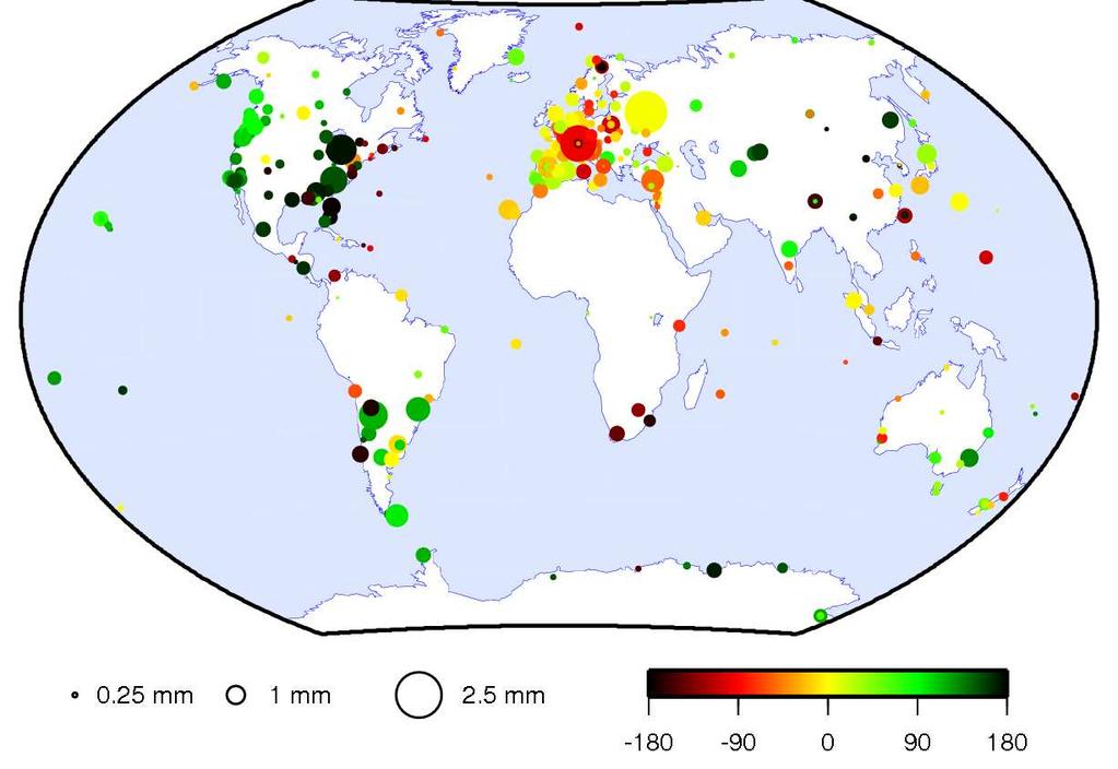
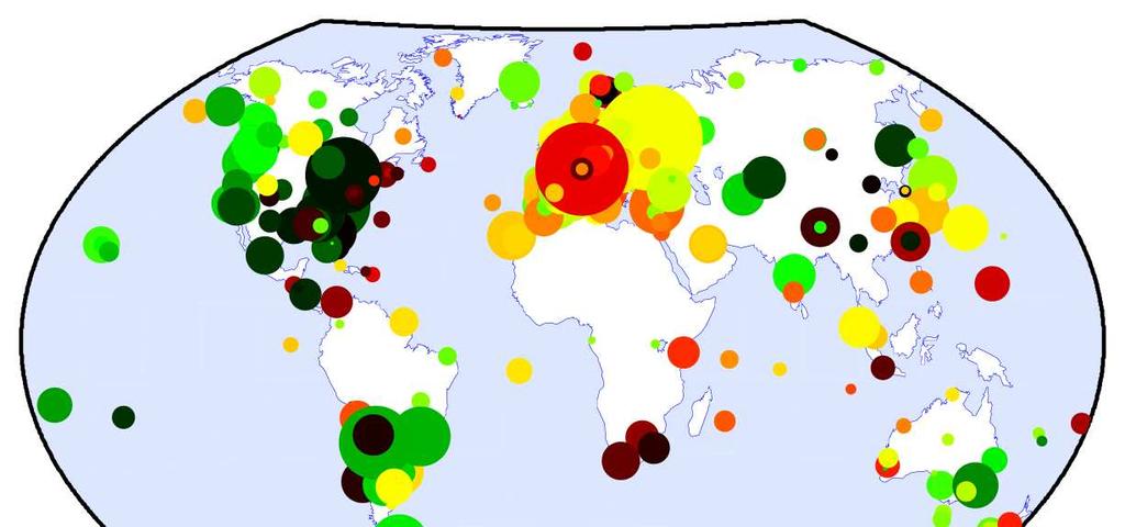
10 Load-correctedIGS positions: semi-annual/2 nd draconitic Semi-annual East Semi-annual North Semi-annual Up 2 nd draconitic East 2 nd draconitic North 2 nd draconitic Up 10

11 Inter-AC discrepancies Are there systematic AC-specific analysis artifacts? How large are they compared to the IGS-load residuals? Investigate residuals of the weekly SINEX combinations = differences between AC and IGS weekly station positions Geophysical signals should cancel out, leaving analysis related effects: Differences in data modeling/selection/weighting Metadata errors Different impacts of common modeling errors (e.g. antenna mis-calibrations, sub-daily EOPs) 11
12 Inter-AC discrepancies: VENE East North Up Seasonal signals Large offsets before ant+rec change 12
13 Inter-AC discrepancies: MCM4 East North Up Offsets due to analysis changes Non constant seasonal amplitude Offsets 13
14 Inter-AC discrepancies: MALI East North Up 2 nd draconitic harmonic Apparent drifts (or offsets?) 14
15 Inter-AC discrepancies: SANT (co-located) East North Up constant AC-specific biases 15
16 Inter-AC discrepancies: Earthquakes Are there differences between AC co-seismic offset estimates? CONZ: IGS weekly combined positions Seeposter by Lercieret et al. CONZ: weekly combination residuals(ac igs) 16
17 Inter-AC discrepancies: Spectra Stacked periodograms (stations present more than 75% over ) Unexpected peaks at 27.55d & 14.4d North Bump near 14d Up 17 17
18 Inter-AC discrepancies: Oceantidal loading Peaksat27.55d & 14.4d probablyexplainedby an errorin the version of hardisp.f distributed in 2006 (Agnew, 2008) Corrected version used at CODE since week 1529: Stacked periodograms of CODE Up residuals: beforeweek1529 afterweek1529 Olderversion stillin use atesa? 18
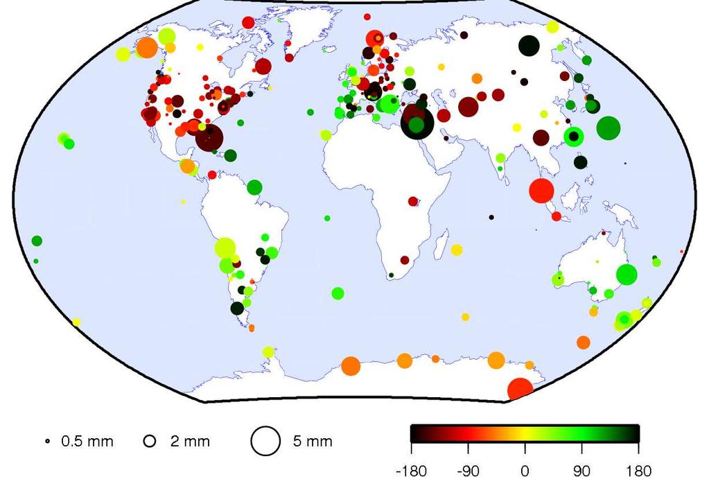
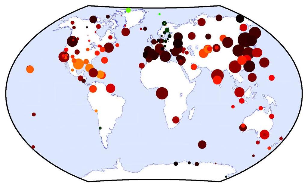
19 Inter-AC discrepancies: Annual-Up COD EMR ESA GFZ IGS-load JPL MIT NGS SIO IGS workshop 2012, Olsztyn, Poland 19 19
20 Inter-AC discrepancies: 1 st draconitic-up COD EMR ESA GFZ IGS-load JPL MIT NGS SIO 20
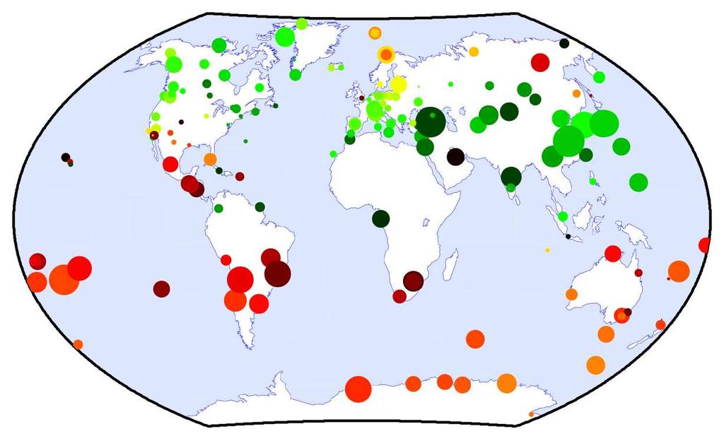
21 Inter-AC discrepancies: Semi-annual-Up COD EMR ESA GFZ IGS-load JPL MIT NGS SIO 21
22 Inter-AC discrepancies: 2 nd draconitic-up COD EMR ESA GFZ IGS-load JPL MIT NGS SIO 22
23 Conclusions (1/2) Load-corrected IGS positions: Simultaneous estimation of annual& draconitic does not significantly improve the agreement between GPS and loading model at the annual frequency. Residual annual& draconitic signals have similar magnitudes. Spatial coherence of draconitic errors suggests major orbit-related source. (e.g., due to errorsin IERS subdailyerp tide model) Inter-AC discrepancies: A lot can be learnt from the weekly combination residual time series. Deeper investigation needed to understand biases and offsets, especially at co-location sites! Two-step combination planned for repro2: 1. Combination 2. Investigation of residualtime series; Exclusion of aberrant AC positions; 2 nd combination 23
24 Conclusions (2/2) Inter-AC discrepancies(continued): Spectral analysis reveals AC specificities: hardisp.f problem Large 2 nd draconiticsignalsin NGS residuals, withstrongspatial coherence(?) JPL residuals often the largest at other frequencies, with less spatial coherence. (modeling difference at the station level?) Inter-AC discrepancies globally smaller than IGS-load residuals, at all frequencies. Common modeling errors(and/or loading model errors) predominant over AC specificities. 24
25 Additionalslides 25


26 Inter-AC discrepancies: Annual-Up COD EMR ESA GFZ IGS-load JPL MIT NGS SIO IGS workshop 2012, Olsztyn, Poland 26


27 Inter-AC discrepancies: 1 st draconitic-up COD EMR ESA GFZ IGS-load JPL MIT NGS SIO


28 Inter-AC discrepancies: Annual-North COD EMR ESA GFZ IGS-load JPL MIT NGS SIO

29 Inter-AC discrepancies: 1 st draconitic-north COD EMR ESA GFZ IGS-load JPL MIT NGS SIO


30 Inter-AC discrepancies: Annual-East COD EMR ESA GFZ IGS-load JPL MIT NGS SIO


31 Inter-AC discrepancies: 1 st draconitic-east COD EMR ESA GFZ IGS-load JPL MIT NGS SIO

32 Inter-AC discrepancies: Semi-annual-Up COD EMR ESA GFZ IGS-load JPL MIT NGS SIO 32

33 Inter-AC discrepancies: 2 nd draconitic-up COD EMR ESA GFZ IGS-load JPL MIT NGS SIO


34 Inter-AC discrepancies: Semi-annual-North COD EMR ESA GFZ IGS-load JPL MIT NGS SIO

35 Inter-AC discrepancies: 2 nd draconitic-north COD EMR ESA GFZ IGS-load JPL MIT NGS SIO

36 Inter-AC discrepancies: Semi-annual-East COD EMR ESA GFZ IGS-load JPL MIT NGS SIO


37 Inter-AC discrepancies: 2 nd draconitic-east COD EMR ESA GFZ IGS-load JPL MIT NGS SIO
Assessment of the orbits from the 1st IGS reprocessing campaign
 Assessment of the orbits from the 1st IGS reprocessing campaign results from combined reprocessed IGS GPS orbits and EOPs assessment of IG1 orbit repeatability items to consider for next reprocessing Jake
ITRF2014 Et la prise en compte des mouvements non linéaires
 ITRF2014 Et la prise en compte des mouvements non linéaires Zuheir Altamimi, Paul Rebischung, Laurent Métivier, Xavier Collilieux E-mail: zuheir.altamimi@ign.fr ITRF2014 Network Key Points Modelling of
Call for space geodetic solutions corrected for non-tidal atmospheric loading (NT-ATML) at the observation level
 at the observation level") Call for space geodetic solutions corrected for non-tidal atmospheric loading (NT-ATML) at the observation level Xavier Collilieux, Tonie van Dam, Zuheir Altamimi Outline: Context Why correcting for non-tidal
Call for space geodetic solutions corrected for non-tidal atmospheric loading (NT-ATML) at the observation level Xavier Collilieux, Tonie van Dam, Zuheir Altamimi Outline: Context Why correcting for non-tidal
IGS Reprocessing. and First Quality Assessment
 IGS Reprocessing Summary of Orbit/Clock Combination and First Quality Assessment Gerd Gendt, GeoForschungsZentrum Potsdam Jake Griffiths, NOAA/National Geodetic Survey Thomas Nischan, GeoForschungsZentrum
PRELIMINARY ANALYSIS OF IGS REPROCESSED ORBIT & POLAR MOTION ESTIMATES
 PRELIMINARY ANALYSIS OF IGS REPROCESSED ORBIT & POLAR MOTION ESTIMATES IGS is reprocessing old GPS data consistently will cover ~1994 present (finish by end of 2009) results for 2000 2008 submitted for
Application of Satellite Laser Ranging for Long- Wavelength Gravity Field Determination
 Application of Satellite Laser Ranging for Long- Wavelength Gravity Field Determination J. C. Ries Center for Space Research The University of Texas at Austin Low Degree Gravity Variations from SLR GRACE
Summary of the 2012 Global Geophysical Fluid Center Workshop
 Summary of the 2012 Global Geophysical Fluid Center Workshop T. van Dam (Uni. Lux), J. Ray (NGS/NOAA), X. Collilieux (IGN) Introduction Review the history of the GGFC Discuss the 2012 Workshop Review recommendations
IGS10, Newcastle upon Tyne England, 28 June 2 July, 2010 Combination of the reprocessed IGS Analysis Center SINEX solutions
 Combination of the reprocessed IGS Analysis Center SINEX solutions Rémi Ferland Geodetic Survey Division Contents Introduction Contribution Combined Products: Coordinates ERP s Apparent Geocenter Summary
IGS POLAR MOTION MEASUREMENTS
 STATUS & PROSPECTS FOR IGS POLAR MOTION MEASUREMENTS Why does the IGS care about EOPs? observations, predictions, & IGS product table Recent pole & pole rate accuracies & error sources Rapid & Final products
Correction to Atmospheric Effects and Spurious Signals in GPS Analyses
 JOURNAL OF GEOPHYSICAL RESEARCH, VOL.???, XXXX, DOI:10.1029/, 1 2 Correction to Atmospheric Effects and Spurious Signals in GPS Analyses P. Tregoning 3 4 Research School of Earth Sciences, The Australian
Using non-tidal atmospheric loading model in space geodetic data processing: Preliminary results of the IERS analysis campaign
 Using non-tidal atmospheric loading model in space geodetic data processing: Preliminary results of the IERS analysis campaign Xavier Collilieux (1), Zuheir Altamimi (1), Laurent Métivier (1), Tonie van
Current status of the ITRS realization
 Current status of the ITRS realization Input data Principles for datum definition Combination strategies (3 CCs) Some notes on ITRF2005 Next ITRF solution (?) Zuheir Altamimi ITRS PC ITRF Input Data Up
New satellite mission for improving the Terrestrial Reference Frame: means and impacts
 Fourth Swarm science meeting and geodetic missions workshop ESA, 20-24 March 2017, Banff, Alberta, Canada New satellite mission for improving the Terrestrial Reference Frame: means and impacts Richard
Preparation for the ITRF2013. Zuheir Altamimi Xavier Collilieux Laurent Métivier IGN, France
 Preparation for the ITRF2013 Zuheir Altamimi Xavier Collilieux Laurent Métivier IGN, France 1 Outline Introduction Solicited solutions Analysis Strategy Preparation for the ITRF2013: Combination tests
Towards a Consistent Conventional Treatment of Surface-Load Induced Deformations
 Towards a Consistent Conventional Treatment of Surface-Load Induced Deformations Hans-Peter Plag(1), Geoff Blewitt, Tom A. Herring (1) Nevada Bureau of Mines and Geology and Seismological Laboratory University
Assessment of the orbit-related sea level error budget for the TOPEX/Poseidon altimetry mission
 Assessment of the orbit-related sea level error budget for the TOPEX/Poseidon altimetry mission Sergei Rudenko (1,2), Saskia Esselborn (1), Tilo Schöne (1) (1) GFZ German Research Centre for Geosciences,
Time Variable Gravity (TVG) in GRGS REPRO2 solution (GR2)
 in GRGS REPRO2 solution (GR2)") Time Variable Gravity (TVG) in GRGS REPRO2 solution (GR2) S. Loyer (1), J.-M. Lemoine (2) and F. Perosanz (2) (1) Collecte Localisation Satellites (CLS, Ramonville Saint-Agne, France) (2) Centre National
Time Variable Gravity (TVG) in GRGS REPRO2 solution (GR2) S. Loyer (1), J.-M. Lemoine (2) and F. Perosanz (2) (1) Collecte Localisation Satellites (CLS, Ramonville Saint-Agne, France) (2) Centre National
South Pacific Sea Level and Climate Monitoring Project
 G E O S C I E N C E A U S T R A L I A South Pacific Sea Level and Climate Monitoring Project GPS Coordinate Time Series, 2007.0 to Manoj N. Deo, Guorong Hu, John Dawson and Minghai Jia Record 2012/34 GeoCat
3.3 Analysis Coordinator
 1. Introduction 2. Analysis of ITRF2014 post-seismic parameterization In this report we outline the activities of the Analysis Coordinator during 2015. The main activities were analysis of the ITRF2014
Joint Inversion of GPS site displacements, ocean bottom pressure models and GRACE gravimetry
 Joint Inversion of GPS site displacements, ocean bottom pressure models and GRACE gravimetry Status JIGOG project R. Rietbroek, J. Kusche, Ch. Dahle, F. Flechtner, R. Schmidt, J. Schröter, M.J.F. Jansen,
Impact of the SRP model on CODE's 5- system orbit and clock solution for the MGEX
 Impact of the SRP model on CODE's 5- system orbit and clock solution for the MGEX L. Prange, E. Orliac, R. Dach, D. Arnold, G. Beutler, S. Schaer, A. Jäggi Astronomical Institute, University of Bern, Switzerland
Evaluation of the impact of atmospheric pressure loading modeling on GNSS data analysis
 Evaluation of the impact of atmospheric pressure loading modeling on GNSS data analysis R. Dach a, J. Böhm b, S. Lutz a, and P. Steigenberger c a Astronomical Institute, University of Bern, Bern, Switzerland
Improving the long-term stability of the GDR orbit solutions
 Improving the long-term stability of the GDR orbit solutions L. Cerri 1, A. Couhert 1, S. Houry 1, F. Mercier 1 (1) CNES Toulouse OSTST Meeting 19-21 Oct. 2011 POD Splinter Session Status of the POD standards
Influence of the Reference Frame Alignment on Station Positions and Velocities: Global or Regional?
 AGU Fall Meeting, San Francisco, USA, 15 19 December 2008 Influence of the Reference Frame Alignment on Station Positions and Velocities: Global or Regional? J. Legrand(1), N. Bergeot(1), C. Bruyninx(1),
Earth gravity field recovery using GPS, GLONASS, and SLR satellites
 13-01-08 Earth gravity field recovery using GPS, GLONASS, and SLR satellites Krzysztof Sośnica (1), Adrian Jäggi (1), Daniela Thaller (2), Ulrich Meyer (1), Christian Baumann (1), Rolf Dach (1), Gerhard
The International Terrestrial Reference System and ETRS89: Part I : General concepts
 The International Terrestrial Reference System and ETRS89: Part I : General concepts Zuheir ALTAMIMI Laboratoire de Recherche en Géodésie Institut national de l information géographique et forestière (IGN),
Precise Point Positioning requires consistent global products
 Precise Point Positioning requires consistent global products H. P. Kierulf Hans-Peter Plag Abstract Precise Point Positioning (PPP) is increasingly used to compute time series of point motion in a global
Towards a Rigorous Combination of Space Geodetic Techniques
 Towards a Rigorous Combination of Space Geodetic Techniques Markus Rothacher Forschungseinrichtung Satellitengeodäsie, TU Munich, Germany Abstract: The with all its different components and products, ranging
Principles of the Global Positioning System Lecture 24
 12.540 Principles of the Global Positioning System Lecture 24 Prof. Thomas Herring http://geoweb.mit.edu/~tah/12.540 OVERVIEW Examination of results from Earthscope Reference frame definition: SNARF High-rate
Earth rotation and Earth gravity field from GRACE observations. Lucia Seoane, Christian Bizouard, Daniel Gambis
 Earth rotation and Earth gravity field from GRACE observations Lucia Seoane, Christian Bizouard, Daniel Gambis Observatoire de Paris SYRTE, 61 av. de l'observatoire, 7514 Paris Introduction Gravity field
GNSS-specific local effects at the Geodetic Observatory Wettzell
 GNSS-specific local effects at the Geodetic Observatory Wettzell Peter Steigenberger, Urs Hugentobler, Ralf Schmid Technische Universität München (TUM) Uwe Hessels, Thomas Klügel Bundesamt für Kartographie
Interaction between tidal terms and GPS orbits
 Interaction between tidal terms and GPS orbits Natalia Panafidina, Manuela Seitz, Urs Hugentobler Deutsches Geodätisches Forschungsinstitut (DGFI) Centrum für Geodätische Erdsystemforschung (CGE) München
Past, present and possible updates to the IERS Conventions. J. Ray, NGS G. Petit, BIPM
 Past, present and possible updates to the IERS Conventions J. Ray, NGS G. Petit, BIPM IERS Conventions update: electronic access http://tai.bipm.org/iers/convupdt/listupdt.html Introduction Add a set of
State-of-the-art physical models for calculating atmospheric pressure loading effects
 State-of-the-art physical models for calculating atmospheric pressure loading effects Dudy D. Wijaya, Böhm J., Schindelegger M., Karbon M., Schuh H. Institute of Geodesy and Geophysics, TU Vienna Geodätische
Relationships between mass redistribution, station position, geocenter, and Earth rotation: Results from IGS GNAAC analysis
 Relationships between mass redistribution, station position, geocenter, and Earth rotation: Results from IGS GNAAC analysis Geoff Blewitt Mackay School of Earth Sciences and Engineering University of Nevada,
The effect and correction of non-tectonic crustal deformation for continuous GPS position time series
 The effect and correction of non-tectonic crustal deformation for continuous GPS position time series WANG Min 1,2) SHEN Zheng-Kang 1,3) DONG Da-Nan 4) 1) State Key Laboratory of Earthquake Dynamics, Institute
Influence of subdaily tidal model on station coordinates and GPS orbits
 DFG Research Unit Space-Time Reference Systems for Monitoring Global Change and for Precise Navigation in Space Influence of subdaily tidal model on station coordinates and GPS orbits N. Panafidina, U.
GGOS Bureau for Standards and Conventions
 GGOS D. Angermann (1), T. Gruber (2), J. Bouman (1), M. Gerstl (1), R. Heinkelmann (1), U. Hugentobler (2), L. Sánchez (1), P. Steigenberger (2) (1) Deutsches Geodätisches Forschungsinstitut (DGFI), München
GRACE processing at TU Graz
 S C I E N C E P A S S I O N T E C H N O L O G Y GRACE processing at TU Graz Torsten Mayer-Gürr, Saniya Behzadpour, Andreas Kvas, Matthias Ellmer, Beate Klinger, Norbert Zehentner, and Sebastian Strasser
Assessment of the International Terrestrial Reference System 2014 realizations by Precise Orbit Determination of SLR Satellites
 Deutsches Geodätisches Forschungsinstitut (DGFI-TUM) Technische Universität München Assessment of the International Terrestrial Reference System 2014 realizations by Precise Orbit Determination of SLR
The Effect of the Geocentric Gravitational Constant on Scale
 The Effect of the Geocentric Gravitational Constant on Scale S.Y. Zhu, F.-H. Massmann, Y. Yu, Ch. Reigber GeoForschungsZentrum Potsdam, Division 1 (Submitted to Journal of Geodesy) 1 Abstract It is well
Nutation determination by means of GNSS
 Nutation determination by means of GNSS - Comparison with VLBI Nicole Capitaine, Kunliang Yao SYRTE - Observatoire de Paris, CNRS/UPMC, France Introduction Space geodetic techniques cannot be used for
3.6 ITRS Combination Centres
 3 Reports of IERS components 3.6.1 Deutsches Geodätisches Forschungsinstitut (DGFI) In 2010, the focus of the ITRS Combination Centre at DGFI was on the finalization of the ITRS realization DTRF2008, internal
Mutual comparison of the combinations of the Earth orientation parameters obtained by different techniques
 Mutual comparison of the combinations of the Earth orientation parameters obtained by different techniques C. Ron, J. Vondrák Astronomical Institute, Boční II 141, 141 31 Praha 4, Czech Republic Abstract.
Publ. Astron. Obs. Belgrade No. 91 (2012), REALIZATION OF ETRF2000 AS A NEW TERRESTRIAL REFERENCE FRAME IN REPUBLIC OF SERBIA
, REALIZATION OF ETRF2000 AS A NEW TERRESTRIAL REFERENCE FRAME IN REPUBLIC OF SERBIA") Publ. Astron. Obs. Belgrade No. 91 (2012), 199-206 Contributed paper REALIZATION OF ETRF2000 AS A NEW TERRESTRIAL REFERENCE FRAME IN REPUBLIC OF SERBIA D. BLAGOJEVIĆ and V. VASILIĆ Faculty of Civil Engineering,
Publ. Astron. Obs. Belgrade No. 91 (2012), 199-206 Contributed paper REALIZATION OF ETRF2000 AS A NEW TERRESTRIAL REFERENCE FRAME IN REPUBLIC OF SERBIA D. BLAGOJEVIĆ and V. VASILIĆ Faculty of Civil Engineering,
SLR and the Gravity Field
 SLR and the Gravity Field Daniela Thaller With contributions by: Krzysztof Sośnica (University of Wroclaw, Poland) Mathis Bloßfeld (DGFI-TUM, Germany) Gravity Field Determination Dedicated gravity field
Towards an improved ILRS TRF contribution
 Towards an improved ILRS TRF contribution Erricos C. Pavlis ILRS Analysis Coordinator JCET/ & NASA Goddard IERS Workshop on Conventions 2007 20-21 Sept. 2007, Sèvres, France Overview The ILRS Network Geometry
The APREF Project: First Results and Analysis
 The APREF Project: First Results and Analysis Lennard Huisman 1*, John Dawson 2, and Peter J G Teunissen 1 1 GNSS Research, Curtin University of Technology, Australia, l.huisman@curtin.edu.au 2 Earth Monitoring
Global Mapping Function (GMF): A new empirical mapping function based on numerical weather model data
: A new empirical mapping function based on numerical weather model data") Johannes Böhm, Arthur Niell, Paul Tregoning, and Harald Schuh Global Mapping Function (GMF): A new empirical mapping function based on numerical weather model data Geophysical Research Letters Vol. 33,
Johannes Böhm, Arthur Niell, Paul Tregoning, and Harald Schuh Global Mapping Function (GMF): A new empirical mapping function based on numerical weather model data Geophysical Research Letters Vol. 33,
IGS-related multi-gnss activities at CODE
 IGS-related multi-gnss activities at CODE Lars Prange (1), Rolf Dach (1) Simon Lutz (1), Stefan Schaer (2), Adrian Jäggi (1) (1) Astronomical Institute, University of Bern, Switzerland source: http://boris.unibe.ch/57698/
CODE's multi-gnss orbit and clock solution
 source: https://doi.org/10.7892/boris.68193 downloaded: 13.3.2017 CODE's multi-gnss orbit and clock solution L. Prange, E. Orliac, R. Dach, D. Arnold, G. Beutler, S. Schaer, A. Jäggi Astronomical Institute,
The Global Mapping Function (GMF): A new empirical mapping function based on numerical weather model data
: A new empirical mapping function based on numerical weather model data") The Global Mapping Function (GMF): A new empirical mapping function based on numerical weather model data J. Boehm, A. Niell, P. Tregoning, H. Schuh Troposphere mapping functions are used in the analyses
The Global Mapping Function (GMF): A new empirical mapping function based on numerical weather model data J. Boehm, A. Niell, P. Tregoning, H. Schuh Troposphere mapping functions are used in the analyses
Hydrological Mass Variations due to Extreme Weather Conditions in Central Europe from Regional GRACE 4D Expansions
 Hydrological Mass Variations due to Extreme Weather Conditions in Central Europe from Regional GRACE 4D Expansions Florian Seitz 1, Michael Schmidt 2, C.K. Shum 3, Yiqun Chen 3 1 Earth Oriented Space Science
The JCET/GSFC (SLR) TRF Solution 2004
 TRF Solution 2004") The JCET/GSFC (SLR) TRF Solution 2004 JCET and NASA Goddard Space Flight Center Univ. of Maryland Baltimore County Baltimore, Maryland (epavlis@jcet.umbc.edu) IERS Workshop 2004: IERS Combination Pilot
The JCET/GSFC (SLR) TRF Solution 2004 JCET and NASA Goddard Space Flight Center Univ. of Maryland Baltimore County Baltimore, Maryland (epavlis@jcet.umbc.edu) IERS Workshop 2004: IERS Combination Pilot
Surface Mass Loads from GRACE, GPS, and Earth Rotation
 Surface Mass Loads from GRACE,, and Earth Rotation R. Gross *, G. Blewitt, H.-P. Plag, P. Clarke, D. Lavallée, T. van Dam *Jet Propulsion Laboratory, California Institute of Technology, Pasadena, USA Nevada
Rapid Determination of Earthquake Magnitude using GPS for Tsunami Warning Systems: An Opportunity for IGS to Make a Difference
 Rapid Determination of Earthquake Magnitude using GPS for Tsunami Warning Systems: An Opportunity for IGS to Make a Difference Geoffrey Blewitt, 1 Corné Kreemer, 1 William C. Hammond, 1 Hans-Peter Plag,
Update on the International Terrestrial Reference Frame (ITRF) : ITRF2014. Zuheir Altamimi
 : ITRF2014. Zuheir Altamimi") Update on the International Terrestrial Reference Frame (ITRF) : ITRF2014 Zuheir Altamimi Head of the IERS ITRF Product Center IAG Vice President IGN, France E-mail: zuheir.altamimi@ign.fr Key Points Introduction:
Update on the International Terrestrial Reference Frame (ITRF) : ITRF2014 Zuheir Altamimi Head of the IERS ITRF Product Center IAG Vice President IGN, France E-mail: zuheir.altamimi@ign.fr Key Points Introduction:
Basis functions for the consistent and accurate representation of surface mass loading
 Geophys. J. Int. (27) doi: 1.1111/j.1365-246X.27.3493.x Basis functions for the consistent and accurate representation of surface mass loading Peter J. Clarke, 1 David A. Lavallée, 1 Geoff Blewitt 1,2
Time Evolution of the Terrestrial Reference Frame
 Time Evolution of the Terrestrial Reference Frame D. Angermann, B. Meisel, M. Krügel, H. Müller, V. Tesmer Deutsches Geodätisches Forschungsinstitut (DGFI), Marstallplatz 8, D-89 München, Germany email
Determination of Current Velocity Field (Rate) of North Anatolian Fault in Izmit-Sapanca Segment
 of North Anatolian Fault in Izmit-Sapanca Segment") Determination of Current Velocity Field (Rate) of North Anatolian Fault in Izmit-Sapanca Segment Cetin MEKIK, Bulent TURGUT, Haluk OZENER, Turkish Republic INTRODUCTION Turkey is geologically the part
Determination of Current Velocity Field (Rate) of North Anatolian Fault in Izmit-Sapanca Segment Cetin MEKIK, Bulent TURGUT, Haluk OZENER, Turkish Republic INTRODUCTION Turkey is geologically the part
TIDAL EFFECTS IN GPS/GLONASS DATA PROCESSING
 TIDAL EFFECTS IN GPS/GLONASS DATA PROCESSING R. Weber (1), Carine Bruyninx, H.G. Scherneck, M. Rothacher,P.H. Andersen, T.F. Baker, T. van Dam (1)Institute of Geodesy and Geophysics, TU-Vienna, Gusshausstr.27-29,A-1040
Interaction between subdaily Earth rotation parameters and GPS orbits Natalia Panafidina, Urs Hugentobler, Manuela Seitz
 Interaction between subdaily Earth rotation parameters and GPS orbits Natalia Panafidina, Urs Hugentobler, Manuela Seitz Deutsches Geodätisches Forschungsinstitut (DGFI) Centrum für Geodätische Erdsystemforschung
Spatiotemporal filtering using principal component analysis and Karhunen-Loeve expansion approaches for regional GPS network analysis
 JOURNAL OF GEOPHYSICAL RESEARCH, VOL. 111,, doi: 10.1029/2005JB003806, 2006 Spatiotemporal filtering using principal component analysis and Karhunen-Loeve expansion approaches for regional GPS network
Solid Earth Deformations Induced by the Sumatra Earthquakes of : GPS Detection of Co-Seismic Displacements
 Solid Earth Deformations Induced by the Sumatra Earthquakes of 2-25: GPS Detection of Co-Seismic Displacements and Tsunami-Induced Loading H.-P. Plag, G. Blewitt, C. Kreemer, W.C. Haond Nevada Bureau of
Lecture 2 Measurement Systems. GEOS 655 Tectonic Geodesy
 Lecture 2 Measurement Systems GEOS 655 Tectonic Geodesy VLBI and SLR VLBI Very Long Baseline Interferometry SLR Satellite Laser Ranging Very Long Baseline Interferometry VLBI Geometric Delay δg S Baseline
High Rate GPS Solutions
 High Rate GPS Solutions High rate GPS data (1 Hz or higher) Network solution Fixed a local reference clock Bias fixed Sub daily position estimates solutions Position becomes stochastic parameter Fairly
Tectonics of the terrestrial litosphere in spherical harmonics
 Journal of Physics: Conference Series PAPER OPEN ACCESS Tectonics of the terrestrial litosphere in spherical harmonics To cite this article: A V Mokhnatkin et al 2016 J. Phys.: Conf. Ser. 769 012007 View
ESTIMATES OF HORIZONTAL DISPLACEMENTS ASSOCIATED WITH THE 1999 TAIWAN EARTHQUAKE
 ESTIMATES OF HORIZONTAL DISPLACEMENTS ASSOCIATED WITH THE 1999 TAIWAN EARTHQUAKE C. C. Chang Department of Surveying and Mapping Engineering Chung Cheng Institute of Technology, Taiwan, ROC ABSTRACT A
GPS time series and sea level
 GPS time series and sea level M. Poutanen 1, H. Koivula 1, M. Tervo 1,2, K. Kahma 3, M. Ollikainen 1, H. Virtanen 1 1 Finnish Geodetic Institute, 2 University of Helsinki, 3 Finnish Institute of Marine
A S S O C I A T E A N A L Y S I S C E N T E R S
 I G S A S S O C I A T E A N A L Y S I S C E N T E R S I G S R A P I D S E R V I C E A N D P R E D I C T I O N U.S. Naval Observatory: Center for Rapid Service and Predictions U.S. Naval Observatory:
Beate Klinger, Torsten Mayer-Gürr, Saniya Behzadpour, Matthias Ellmer, Andreas Kvas and Norbert Zehentner
 , Torsten Mayer-Gürr, Saniya Behzadpour, Matthias Ellmer, Andreas Kvas and Norbert Zehentner Institute of Geodesy NAWI Graz, Graz University of Technology Outline ITSG-Grace2016 Processing details Unconstrained
The Victorian Seismic Zone 2011 GNSS Campaign Data Analysis
 G E O S C I E N C E A U S T R A L I A The Victorian Seismic Zone 2011 GNSS Campaign Data Analysis G. Hu Record 2012/38 GeoCat # 74005 APPLYING GEOSCIENCE TO AUSTRALIA S MOST IMPORTANT CHALLENGES The Victorian
Impact of a priori zenith hydrostatic delay errors on GPS estimates of station heights and zenith total delays
 Click Here for Full Article GEOPHYSICAL RESEARCH LETTERS, VOL. 33, L23303, doi:10.1029/2006gl027706, 2006 Impact of a priori zenith hydrostatic delay errors on GPS estimates of station heights and zenith
Integration of space and terrestrial techniques to study crustal deformation. Examples in northeastern Italy
 Integration of space and terrestrial techniques to study crustal deformation. Examples in northeastern Italy Susanna Zerbini Dipartimento di Fisica, University of Bologna, Italy IAG-IASPEI Joint Capacity
Frequent epoch reference frames instead of instant station positions and constant velocities
 Deutsches Geodätisches Forschungsinstitut Technische Universität München (DGFI-TUM) Frequent epoch reference frames instead of instant station positions and constant velocities Hermann Drewes Deutsches
Consistent realization of Celestial and Terrestrial Reference Frames
 Journal of Geodesy manuscript - accepted version (minor errata corrected) The official publication is available at Springer via https://doi.org/10.1007/s00190-018-1130-6 Consistent realization of Celestial
Current Status of Non-conservative Force Modelling:
 Current Status of Non-conservative Force Modelling: Interface to REPRO2 Marek Ziebart, Stuart Grey and Shawn Allgeier Chair, IGS working group on Space Vehicle Orbit Dynamics Space Geodesy and Navigation
Earth gravity field recovery using GPS, GLONASS, and SLR satellites
 Earth gravity field recovery using GPS, GLONASS, and SLR satellites Krzysztof Sośnica (1), Adrian Jäggi (1), Daniela Thaller (2), Ulrich Meyer (1), Gerhard Beutler (1), Rolf Dach (1) (1) Astronomical Institute,
The International Terrestrial Reference System and ETRS89: Part II : ITRS & ETRS89 relationship
 The International Terrestrial Reference System and ETRS89: Part II : ITRS & ETRS89 relationship Zuheir ALTAMIMI Laboratoire de Recherche en Géodésie Institut national de l information géographique et forestière
Electronic supplement for Forearc motion and deformation between El Salvador and Nicaragua: GPS, seismic, structural, and paleomagnetic observations
 DR2011053 Electronic supplement for Forearc motion and deformation between El Salvador and Nicaragua: GPS, seismic, structural, and paleomagnetic observations by D. Alvarado et al., Lithosphere, April,
THREE SEASONAL BEHAVIOUR OF THE BALKAN PENINSULA GNSS PERMANENT STATIONS FROM GPS SOLUTIONS
 Доклади на Българската академия на науките Comptes rendus de l Académie bulgare des Sciences Tome 66, No 1, 2013 GEOPHYSIQUE Sismologie THREE SEASONAL BEHAVIOUR OF THE BALKAN PENINSULA GNSS PERMANENT STATIONS
Jason-1 orbit comparison : POE-E versus POE-D. L. Zawadzki, M. Ablain (CLS)
") Jason-1 orbit comparison : versus POE-D L. Zawadzki, M. Ablain (CLS) Jason-1 orbit comparison : versus POE-D Objectives Evaluate orbit for Jason-1 (by comparison to POE-D standard) Observe and analyse
Jason-1 orbit comparison : versus POE-D L. Zawadzki, M. Ablain (CLS) Jason-1 orbit comparison : versus POE-D Objectives Evaluate orbit for Jason-1 (by comparison to POE-D standard) Observe and analyse
The APREF Project. The Asia-Pacific regional geodetic
 The GEODESY APREF Project The Asia-Pacifi c Reference Frame (APREF) is an initiative that recognizes the importance of improving the regional geodetic framework in the Asia-Pacifi c region Lennard Huisman
Very Long Baseline Interferometry for Geodesy and Astrometry
 VieVS User-Workshop 2017 Very Long Baseline Interferometry for Geodesy and Astrometry Johannes Böhm VLBI How does it work? VLBI a flowchart SINEX skd vex2 drudge drudge snp/prc snp/prc NGS Mark4 Mark4
Characteristics of GPS ZTD products. Jan Douša EUREF Analysis Centre Workshop
 Characteristics of GPS ZTD products Jan Douša EUREF Analysis Centre Workshop March 15-16, 2006 Outline ZTD and PWV products Stragegy changes GPS constellation effect solution characteristics ZTD differences
Principles of the Global Positioning System Lecture 18" Mathematical models in GPS" Mathematical models used in GPS"
 12.540 Principles of the Global Positioning System Lecture 18" Prof. Thomas Herring" Room 54-820A; 253-5941" tah@mit.edu" http://geoweb.mit.edu/~tah/12.540 " Mathematical models in GPS" Review assignment
A priori gradients in the analysis of GPS and VLBI observations
 A priori gradients in the analysis of GPS and VLBI observations Peter Steigenberger GeoForschungsZentrum Potsdam Volker Tesmer Deutsche Geodätisches Forschungsinstitut, München Johannes Boehm Institute
Your Advisor Said, Get the GPS Data and Plot it. Jeff Freymueller Geophysical University of Alaska Fairbanks
 Your Advisor Said, Get the GPS Data and Plot it Jeff Freymueller Geophysical Ins@tute University of Alaska Fairbanks Actual GPS Data GPS Data are phase and pseudorange data that measure distances to satellites.
Deriving groundwater estimates in Australia from GRACE observations
 Deriving groundwater estimates in Australia from GRACE observations P. Tregoning 1 and S.C. McClusky 1 1 Research School of Earth Sciences, The Australian National University, Canberra, ACT, 0200, Australia,
Gravimetric Tide observation at Lake Nasser Region, Aswan, Egypt
 Gravimetric Tide observation at Lake Nasser Region, Aswan, Egypt R.M. Hassan, E.M. Abdelrahman, A. Tealeb, K.H. Zahran and G. Jentzsch ABSTRACT The LaCoste and Romberg gravimeter D-218 of the National
A. Barbu, J. Laurent-Varin, F. Perosanz, F. Mercier and J. Marty. AVENUE project. June, 20
 Efficient QR Sequential Least Square algorithm for high frequency GNSS Precise Point Positioning A. Barbu, J. Laurent-Varin, F. Perosanz, F. Mercier and J. Marty AVENUE project June, 20 A. Barbu, J. Laurent-Varin,
Global reference systems and Earth rotation
 current realizations and scientific problems Aleksander Brzeziński 1,2, Tomasz Liwosz 1, Jerzy Rogowski 1, Jan Kryński 3 1 Department of Geodesy and Geodetic Astronomy Warsaw University of Technology 2
Hydrological deformation induced by the West African Monsoon: Comparison of GPS, GRACE and loading models
 JOURNAL OF GEOPHYSICAL RESEARCH, VOL. 117,, doi:10.1029/2011jb009102, 2012 Hydrological deformation induced by the West African Monsoon: Comparison of GPS, GRACE and loading models Samuel Nahmani, 1 Olivier
Orbit comparison for Jason-2 mission between GFZ and CNES (POE-D)
") Orbit comparison for Jason-2 mission between GFZ and CNES (POE-D) The GFZ orbit is referred to as GFZ in the following study The CNES orbit is referred to as SL_cci Lionel Zawadzki, Michael Ablain (CLS)
Orbit comparison for Jason-2 mission between GFZ and CNES (POE-D) The GFZ orbit is referred to as GFZ in the following study The CNES orbit is referred to as SL_cci Lionel Zawadzki, Michael Ablain (CLS)
Status of Precise Orbit Determination for Altimeter Satellites at GSFC
 Status of Precise Orbit Determination for Altimeter Satellites at GSFC F.G. Lemoine 1, N.P. Zelensky 2, D.S. Chinn 2, B.D. Beckley 2, D.E.Pavlis 2 (1) NASA GSFC, Greenbelt, Maryland, USA (2) SGT Inc.,
Effect of post-seismic deformation on earth orientation parameter estimates from VLBI observations: a case study at Gilcreek, Alaska
 J Geod (2005) DOI 10.1007/s00190-005-0459-9 ORIGINAL ARTICLE O. Titov P. Tregoning Effect of post-seismic deformation on earth orientation parameter estimates from VLBI observations: a case study at Gilcreek,
This article appeared in a journal published by Elsevier. The attached copy is furnished to the author for internal non-commercial research and
 This article appeared in a journal published by Elsevier. The attached copy is furnished to the author for internal non-commercial research and education use, including for instruction at the authors institution
Real-Time Estimation of GPS Satellite Clocks Based on Global NTRIP-Streams. André Hauschild
 Real-Time Estimation of GPS Satellite Clocks Based on Global NTRIP-Streams André Hauschild Agenda Motivation Overview of the real-time clock estimation system Assessment of clock product quality a) SISRE
Overview of the ILRS contribution to the development of ITRF2013
 Overview of the ILRS contribution to the development of ITRF203 V. Luceri, E. C. Pavlis 2, B. Pace, D. König 2, M. Kuzmicz-Cieslak 2, G. Bianco 3 ) e-geos S.p.A., Centro di Geodesia Spaziale, Matera, Italy
CODE s new solar radiation pressure model for GNSS orbit determination
 Noname manuscript No. (will be inserted by the editor) CODE s new solar radiation pressure model for GNSS orbit determination D. Arnold M. Meindl G. Beutler R. Dach S. Schaer S. Lutz L. Prange K. Sośnica