Integration of space and terrestrial techniques to study crustal deformation. Examples in northeastern Italy
|
|
|
- Jennifer Tabitha Harrington
- 5 years ago
- Views:
Transcription
1

2 Integration of space and terrestrial techniques to study crustal deformation. Examples in northeastern Italy Susanna Zerbini Dipartimento di Fisica, University of Bologna, Italy IAG-IASPEI Joint Capacity Workshop on Deformation Measurements & Understanding Natural Hazards in Developing Countries Trieste, January, 2005
3 Fine-tuning in the knowledge of station motions has not yet been reached. Detailed knowledge will allow Better understanding of geophysical processes responsible of horizontal and vertical deformation; Constraining the physical models describing the deformations of the Earth; Contributing to high-precision reference frame realizations. Validation and crosschecking of techniques is necessary to understand the error sources and to fully exploit the potential of each single technique.
4 Integration allows to take advantage of the complementary strengths of the single techniques (GPS, VLBI, SLR, InSAR, gravimetry.). VLBI, SLR limited number of stations around the globe major importance for global reference frame GPS networks, though dense, provide information, which is continuous in time, however, is not spatially continuous. InSAR has proven capability to provide spatially continuous information, which, however, is limited in temporal coverage.


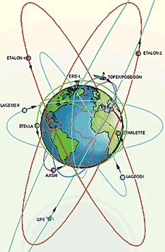
5 LAGEOS II GPS Satellite Laser Ranging SLR VLBI Absolute and relative gravimetry

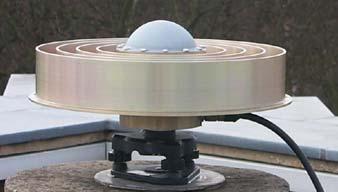
6 IGS GPS network
7
8 SLR concept In Satellite Laser Ranging, a short pulse of coherent light generated by a laser (Light Amplification by Stimulated Emission of Radiation) is transmitted in a narrow beam to illuminate corner cube retroreflectors on the satellite. The return signal, typically a few photons, is collected by a telescope and the time-of-flight is measured. Using information about the satellite s orbit, the time-of-flight, and the speed of light, the location of the ranging station can be determined. Similar data acquired by another station, many kilometers distant from the first, or on a different continent, can be used to determine the distance between stations to precisions of a few mm. Repetitive measurements over months and years yield the change in distance, or the motion of the Earth s crust.
9 SLR satellites

10 SLR Network


11 3 French SLR systems at Grasse Riyadh SLR system Matera LRO

12 VLBI concept VLBI is a geometric technique: it measures the time difference between b the arrival at two Earth-based antennas of a radio wavefront emitted by a distant quasar. Because the time difference measurements are precise to a few picoseconds, VLBI determines the relative positions of the antennas to a few millimeters

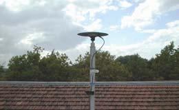
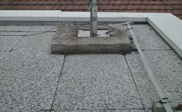
13 VLBI network

14 Hartebeesthoek, South Africa, 26 m Medicina, Italy, 32 m

15 TIGO Conception, Chile, VLBI 6m
16 InSAR Permanent Scatters (PS) technique Stable natural reflectors (PS) can be identified from long temporal series of interferometric data. PS are parts of buildings, metallic structures etc. PS constitute a sort of natural geodetic network, a monitoring tool with very high spatial density of measurements.
17 The combination of GPS and InSAR provides the ability to observe time and space continuous deformation by taking advantage of the complementary strengths of the two techniques. GPS provides absolute positions and is, at present, the only technique contributing time continuous information, however, limited to the station location. InSAR results are relative to a reference point. The technique provides spatially continuous information, which, however, is limited in temporal coverage.


18 Gravimetry Among the terrestrial observation techniques used for the estimate of vertical land movements, gravimetry is a completely independent method with respect to space techniques.

19 Examples of comparisons of techniques GPS network of Dept.of Physics, Univ. Bologna Medicina and Bologna are EPN/ECGN stations InSAR data available for Bologna, Medicina and Marina di Ravenna

20 Medicina station Piezometric hole 2 g Laboratory Piezometric hole 1 GPS ASI VLBI GPS UniBO
21 49,365 Medicina GPS Height 49,360 Height (m) 49,355 49,350 49,345 49,340 49, ± 0.05 mm/yr 49,330 49,325 J M S J M S J M S J M S J M S J M S J M S J M S J M Time Height (m) 49,365 49,360 49,355 49,350 49,345 49,340 49,335 49,330 49, ± 0.07 mm/yr 49,365 49,360 J M S J M S J M S J M S J M S J M S J Time Height (m) 49,355 49,350 49,345 49,340-1,54 ± 0,05 mm/yr Differences due to length of time series but also to data treatment 49,335 J M S J M S J M S J M S J M S J M S J M S J Time
 0,000-0,005-0,010-0,015 Jan May Sep Jan May Sep Jan May Sep Jan May Sep Jan May Sep Jan May Sep Jan May Sep Jan 1996 1997 1998 1999 2000 2001 2002")
22 Modeling the height seasonal oscillations Observed height oscillation 0,015 0,010 Non-tidal ocean loading Air pressure loading Hydrological balance loading Thermal expansion 0,005 (m) 0,000-0,005-0,010-0,015 Jan May Sep Jan May Sep Jan May Sep Jan May Sep Jan May Sep Jan May Sep Jan May Sep Jan Time
23 Model of the seasonal oscillations 0,015 0,010 Model Observed height oscillation 0,005 (m) 0,000-0,005-0,010-0,015 Jan May Sep Jan May Sep Jan May Sep Jan May Sep Jan May Sep Jan May Sep Jan May Sep Jan Time
24 Long-term trend 49,370 49,365 Height - model (m) 49,360 49,355 49,350 49,345 49, ± 0.05 mm/yr 49,335 49,330 J M S J M S J M S J M S J M S J M S J M S J Time Height residuals (m) 0,015 0,010 0,005 0,000-0,005 Height residuals 1,5 1,0 0,5 0,0-0,5-1,0-1,5-2,0 Water table (m) -0,010-2,5-3,0-0,015-3,5 J M S J M S J M S J M S J M S J M S J M S J Time Improved modeling of the seasonal oscillations needed for reliable estimates of long-term trends
25 Gravity at Medicina g (µgal) ,68±0,03 µgal/yr Jan May Sep Jan May Sep Jan May Sep Jan May Sep Jan May Sep Jan May Sep Jan Time g (µgal) Jan May Sep Jan May Sep Jan May Sep Jan May Sep Jan May Sep Jan May Sep Jan Time
26 Modeling the seasonal oscillations observed gravity oscillation vertical air mass non-tidal ocean hydrological balance Model observed gravity oscillations µgal 0 µgal Jan May Sep Jan May Sep Jan May Sep Jan May Sep Jan May Sep Jan Time -5 Jan May Sep Jan May Sep Jan May Sep Jan May Sep Jan May Sep Jan Time
27 Long-term trend Gravity residuals µgal ,15±0,02 µgal/yr Jan May Sep Jan May Sep Jan May Sep Jan May Sep Jan May Sep Jan Time µgal Water Table (m) Jan May Sep Jan May Sep Jan May Sep Jan May Sep Jan May Sep Jan Time
28 Medicina height variations from different techniques and solutions ± 0.07 mm/yr CGPS UNIBO ± 0.15 mm/yr VLBI NASA solution (courtesy of D. McMillan) ± 0.02 µgal/yr ~ -3.8 mm/yr SG data ± 0.06 mm/yr CGPS UNIBO -2.6 ± 0.5 mm/yr CGPS ASI SOPAC solution ± 0.14 mm/yr VLBI NASA solution (courtesy of D. McMillan) ± 0.30 mm/yr VLBI DGFI solution (courtesy of V. Tessmar) ± 0.26 mm/yr VLBI BKG solution

29 InSAR PS Medicina and Bologna

30 InSAR PS Medicina station

31

32

33 Horizontal motions Comparison at Medicina

34 Bologna InSAR PS -16,0 mm/yr relative to the reference point in the Medicina area GPS and Absolute gravity
35 Bologna GPS 99,66 99,64 99, ± 0.08 mm/yr Gravity Height (m) 99,60 99,58 99,56 99,54 Jan May Sep Jan May Sep Jan May Sep Jan May Sep Jan May Sep Jan May Time Absolute Gravity (µgal/yr) ± 1.19 µgal/yr Sep Jan May Sep Jan May Sep Jan May Sep Jan Time ~-17 mm/yr

36 InSAR PS Marina di Ravenna GPS mm/yr
37 GPS Marina di Ravenna 44, ± 0.04 mm/yr 44,32 Height (m) 44,30 44,28 44,26 44,24 44,22 May Sep Jan May Sep Jan May Sep Jan May Sep Jan May Sep Jan May Sep Jan May Sep Jan May Sep Jan May Time

38 RIMINI IGEA MARINA BELLARIA VILLAMARINA CESENATICO PINARELLA SAVIO FOSSO GHIAIA CLASSE RAVENNA MEZZANO ALFONSINE IL CASINO S. BIAGIO ARGENTA CONSANDOLO PORTOMAGGIORE PUNTA DI FERRARA Marina di Ravenna High-precision leveling Subsidence rate from Rimini to Ferrara. From Benedetti et al., Proc. 6th Int. Symposium on Land Subsidence, Ravenna, Sept Cesenatico 7-8 mm/yr subsidence mm/yr
39 Conclusions A first comparison of the long-term height variations derived from space and terrestrial techniques yields satisfactory results; However, there are still differences to be interpreted. A thorough comparison between GPS and InSAR requires accurate knowledge of the motion of the InSAR reference PS and/or realization of a reliable geodetic PS near the GPS antenna;
 Both the GPS and gravity time series exhibit significant seasonal oscillations of similar amplitude")

40 Conclusions (cont.) Both the GPS and gravity time series exhibit significant seasonal oscillations of similar amplitude (peak-to-peak 1.5 cm for GPS and about 2 cm for gravity); They have been modeled. Improved understanding/modeling of the local hydrology is necessary. Removal of the seasonal oscillation reduces the sd of the residual series (ex. from 2 to 1 µgal for gravity at Medicina) and changes the estimate of the long-term trend
Fundamental Station Wettzell - geodetic observatory -
 Fundamental Station Wettzell - geodetic observatory - Wolfgang Schlüter Bundesamt für Kartographie und Geodäsie, Fundamental Station Wettzell Germany Radiometer Workshop, Wettzell, 10.10.06 Evolvement
DETERMINATION OF THE STATION COORDINATES FOR QUALITY CONTROL OF THE SATELLITE LASER RANGING DATA S.
 DETERMINATION OF THE STATION COORDINATES FOR QUALITY CONTROL OF THE SATELLITE LASER RANGING DATA S. Schillak Space Research Centre of the Polish Academy of Sciences. Astrogeodynamic Observatory, Borowiec
Lecture 2 Measurement Systems. GEOS 655 Tectonic Geodesy
 Lecture 2 Measurement Systems GEOS 655 Tectonic Geodesy VLBI and SLR VLBI Very Long Baseline Interferometry SLR Satellite Laser Ranging Very Long Baseline Interferometry VLBI Geometric Delay δg S Baseline
A Unique Reference Frame: Basis of the Global Geodetic Observing System (GGOS) for Geodynamics and Global Change
 for Geodynamics and Global Change") SRTM (InSAR) A Unique Reference Frame: Basis of the Global Geodetic Observing System (GGOS) for Geodynamics and Global Change Hermann Drewes President IAG Commission 1 Reference Frames Deutsches Geodätisches
SRTM (InSAR) A Unique Reference Frame: Basis of the Global Geodetic Observing System (GGOS) for Geodynamics and Global Change Hermann Drewes President IAG Commission 1 Reference Frames Deutsches Geodätisches
GGOS Bureau for Standards and Conventions
 GGOS D. Angermann (1), T. Gruber (2), J. Bouman (1), M. Gerstl (1), R. Heinkelmann (1), U. Hugentobler (2), L. Sánchez (1), P. Steigenberger (2) (1) Deutsches Geodätisches Forschungsinstitut (DGFI), München
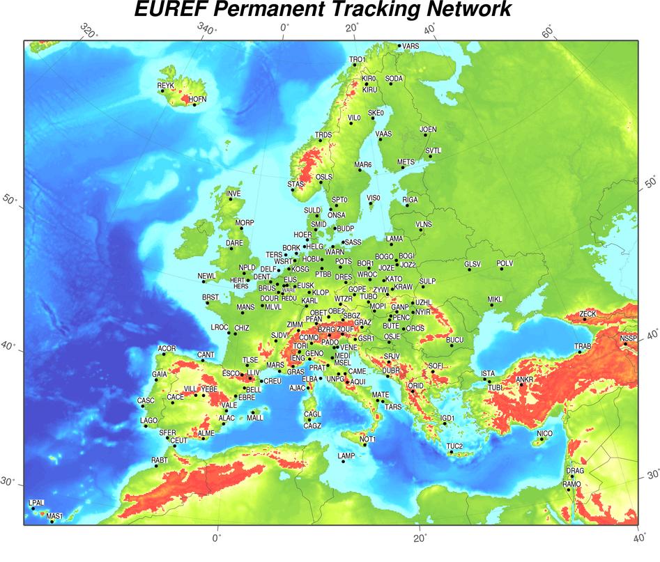
Status. EUREF TWG Meeting November 8 9, 2004, Praha
 ECGN was initiated by IAG Sub-Commission for Europe EUREF (SC1.3a) and IAG Sub-Commission for Europe of the International Gravity and Geoid Commission (IGGC) with relationship to Joint Research Centre
GG S. Internal Vision of GGOS. Markus Rothacher. GFZ Potsdam
 Internal Vision of GGOS Markus Rothacher GFZ Potsdam GGOS Retreat DGFI in Munich February 15-16, 2006 Contents Motivation Four Levels of Products of the IAG Services: First Level: Raw Data Collection Second
INTERNATIONAL SLR SERVICE
 ARTIFICIAL SATELLITES, Vol. 46, No. 4 2011 DOI: 10.2478/v10018-012-0004-z INTERNATIONAL SLR SERVICE Stanisław Schillak Space Research Centre, Polish Academy of Sciences Astrogeodynamic Observatory, Borowiec
The Global Geodetic Observing System (GGOS) of the International Association of Geodesy, IAG
 of the International Association of Geodesy, IAG") The Global Geodetic Observing System (GGOS) of the International Association of Geodesy, IAG Hans-Peter Plag (1), Markus Rothacher (2), Richard Gross (3), Srinivas Bettadpur (4) (1) Nevada Bureau of Mines
The Global Geodetic Observing System (GGOS) of the International Association of Geodesy, IAG Hans-Peter Plag (1), Markus Rothacher (2), Richard Gross (3), Srinivas Bettadpur (4) (1) Nevada Bureau of Mines
Torsten Mayer-Gürr Institute of Geodesy, NAWI Graz Technische Universität Graz
 GGOS and Reference Systems Introduction 2015-10-12 Torsten Mayer-Gürr Institute of Geodesy, NAWI Graz Technische Universität Graz Torsten Mayer-Gürr 1 Course and exam Lecture Monday 14:00 16:00, A111 (ST01044)
Application of Satellite Laser Ranging for Long- Wavelength Gravity Field Determination
 Application of Satellite Laser Ranging for Long- Wavelength Gravity Field Determination J. C. Ries Center for Space Research The University of Texas at Austin Low Degree Gravity Variations from SLR GRACE
Geodetic Very Long Baseline Interferometry (VLBI)
") Geodetic Very Long Baseline Interferometry (VLBI) A brief Note compiled by: Prof. Madhav N. Kulkarni, IIT Bombay Since the inception of the Very Long Baseline Interferometry (VLBI) system in 1967, this
Geodetic Very Long Baseline Interferometry (VLBI) A brief Note compiled by: Prof. Madhav N. Kulkarni, IIT Bombay Since the inception of the Very Long Baseline Interferometry (VLBI) system in 1967, this
CHINA-ITALY BILATERAL SYMPOSIUM ON THE COASTAL ZONE: EVOLUTION AND SAFEGUARD
 CHINA-ITALY BILATERAL SYMPOSIUM ON THE COASTAL ZONE: EVOLUTION AND SAFEGUARD 4-8 November 2007 Bologna, ITALY Editors F.Marabini, A.Galvani, M.Ciabatti Editorial Assistant M.Barazutti C.N.R. Bologna LAND
Long-term crustal deformation monitored by gravity and space techniques at Medicina, Italy and Wettzell, Germany
 Journal of Geodynamics 38 (2004) 281 292 Long-term crustal deformation monitored by gravity and space techniques at Medicina, Italy and Wettzell, Germany B. Richter a,, S. Zerbini b, F. Matonti b, D. Simon
Geodetic Observing Systems: tools in observing the Glacial Isostatic Adjustment. Markku Poutanen Finnish Geodetic Institute
 Geodetic Observing Systems: tools in observing the Glacial Isostatic Adjustment Markku Poutanen Finnish Geodetic Institute Glacial Isostatic Adjustment Land uplift is just one consequence of the physical
A Combination of Space and Terrestrial Geodetic Techniques to Monitor Land Subsidence: Case Study, the Southeastern Po Plain, Italy
 JOURNAL OF GEOPHYSICAL RESEARCH, VOL. 112,, doi:10.1029/2006jb004338, 2007 A Combination of Space and Terrestrial Geodetic Techniques to Monitor Land Subsidence: Case Study, the Southeastern Po Plain,
Ludwig Combrinck HartRAO 3rd Space Geodesy Workshop 16 March 2009 Matjiesfontein
 Space Geodesy and Space Science Ludwig Combrinck HartRAO 3rd Space Geodesy Workshop 16 March 2009 Matjiesfontein DST s Concept of Space Science SA Space Agency, commercial applications, CSIR Satellite
Report for 15th PCGIAP Meeting at 18th UNRCC-AP Working Group 1 Regional Geodesy
 Report for 15th PCGIAP Meeting at 18th UNRCC-AP Working Group 1 Regional Geodesy Chairman Shigeru Matsuzaka, Japan - shigeru@gsi.go.jp Vice Chairman Prof. Pengfei Cheng, China - chengpf@casm.ac.cn John
Delay compensated Optical Time and Frequency Distribution for Space Geodesy
 Delay compensated Optical Time and Frequency Distribution for Space Geodesy U. Schreiber 1, J. Kodet 1, U. Hessels 2, C. Bürkel 2 1 Technische Universität München, GO- Wettzell 2 Bundesamt für Kartographie
THE EARTH - GEODESY, KINEMATICS, DYNAMICS
 THE EARTH - GEODESY, KINEMATICS, DYNAMICS OUTLINE Shape: Geodetic Measurements Geodesy = science of the figure of the Earth; its relation to astronomy and the Earth s gravity field The geoid (mean sea
Towards an improved ILRS TRF contribution
 Towards an improved ILRS TRF contribution Erricos C. Pavlis ILRS Analysis Coordinator JCET/ & NASA Goddard IERS Workshop on Conventions 2007 20-21 Sept. 2007, Sèvres, France Overview The ILRS Network Geometry
Absolute gravimetry. Gabriel Strykowski Geodynamics Department DTU-Space (formerly Danish National Space Center)
") Absolute gravimetry by Gabriel Strykowski Geodynamics Department DTU-Space (formerly Danish National Space Center) gs@space.dtu.dk Contents 1. Instrumentation 2. Absolute gravity measurements: applications
Absolute gravimetry by Gabriel Strykowski Geodynamics Department DTU-Space (formerly Danish National Space Center) gs@space.dtu.dk Contents 1. Instrumentation 2. Absolute gravity measurements: applications
New satellite mission for improving the Terrestrial Reference Frame: means and impacts
 Fourth Swarm science meeting and geodetic missions workshop ESA, 20-24 March 2017, Banff, Alberta, Canada New satellite mission for improving the Terrestrial Reference Frame: means and impacts Richard
STATISTICAL EVALUATION OF THE STABILITY OF VLBI, SLR, DORIS AND GPS STATIONS
 STATISTICAL EVALUATION OF THE STABILITY OF VLBI, SLR, DORIS AND GPS STATIONS K. Le Bail (1), O. de Viron (), M. Feissel-Vernier (3), (1) Institut Géographique National/LAREG, Marne La Vallée, France and
Establishment of a Global Absolute Gravity Network
 Establishment of a Global Absolute Gravity Network H. Wilmes 1), H. Wziontek 1), R. Falk 1), J. Ihde 1), S. Bonvalot 2), R. Forsberg 3), S. Kenyon 4), L. Vitushkin 5) 1) Federal Agency for Cartography
Update on the International Terrestrial Reference Frame (ITRF) : ITRF2014. Zuheir Altamimi
 : ITRF2014. Zuheir Altamimi") Update on the International Terrestrial Reference Frame (ITRF) : ITRF2014 Zuheir Altamimi Head of the IERS ITRF Product Center IAG Vice President IGN, France E-mail: zuheir.altamimi@ign.fr Key Points Introduction:
Update on the International Terrestrial Reference Frame (ITRF) : ITRF2014 Zuheir Altamimi Head of the IERS ITRF Product Center IAG Vice President IGN, France E-mail: zuheir.altamimi@ign.fr Key Points Introduction:
Strategy for the Realization of the International Height Reference System (IHRS)
") Deutsches Geodätisches Forschungsinstitut (DGFI-TUM) Technische Universität München Strategy for the Realization of the International Height Reference System (IHRS) Laura Sánchez 1, Johannes Ihde 2, Roland
Deutsches Geodätisches Forschungsinstitut (DGFI-TUM) Technische Universität München Strategy for the Realization of the International Height Reference System (IHRS) Laura Sánchez 1, Johannes Ihde 2, Roland
The financial and communal impact of a catastrophe instantiated by. volcanoes endlessly impact on lives and damage expensive infrastructure every
 Chapter 1 Introduction The financial and communal impact of a catastrophe instantiated by geophysical activity is significant. Landslides, subsidence, earthquakes and volcanoes endlessly impact on lives
SIRGAS: Basis for Geosciences, Geodata, and Navigation in Latin America
 SIRGAS: Basis for Geosciences, Geodata, and Navigation in Latin America Claudio Brunini President of SIRGAS Universidad Nacional de La Plata, Argentina María Virginia Mackern President of SIRGAS/WG-I:
Interferometric Synthetic Aperture Radar (InSAR) and GGOS. Andrea Donnellan NASA/JPL February 21, 2007
 and GGOS. Andrea Donnellan NASA/JPL February 21, 2007") Interferometric Synthetic Aperture Radar (InSAR) and GGOS Andrea Donnellan NASA/JPL February 21, 2007 Sources for Science Objectives Fourth component of EarthScope Involvement: NSF, NASA, USGS, Universities
Interferometric Synthetic Aperture Radar (InSAR) and GGOS Andrea Donnellan NASA/JPL February 21, 2007 Sources for Science Objectives Fourth component of EarthScope Involvement: NSF, NASA, USGS, Universities
GRACE impact in geodesy and geophysics. R. Biancale (GRGS-CNES Toulouse), M. Diament (IPG Paris)
, M. Diament (IPG Paris)") GRACE impact in geodesy and geophysics R. Biancale (GRGS-CNES Toulouse), M. Diament (IPG Paris) Improvement of gravity models Since 2002 the GRACE mission has changed some goals in geodesy. It has become
GRACE impact in geodesy and geophysics R. Biancale (GRGS-CNES Toulouse), M. Diament (IPG Paris) Improvement of gravity models Since 2002 the GRACE mission has changed some goals in geodesy. It has become
Case study of Japan: Reference Frames in Practice
 Case study of Japan: Reference Frames in Practice Basara Miyahara and Koji Matsuo Sponsors: 1 Outline Introduction - Geodetic reference frame of Japan - GEONET : continuous GNSS observation system Geometric
Observing and assessing nontidal ocean loading using ocean, continuous GPS and gravity data in the Adriatic area
 GEOPHYSICAL RESEARCH LETTERS, VOL. 31, L23609, doi:10.1029/2004gl021185, 2004 Observing and assessing nontidal ocean loading using ocean, continuous GPS and gravity data in the Adriatic area S. Zerbini,
The Potential of High Resolution Satellite Interferometry for Monitoring Enhanced Oil Recovery
 The Potential of High Resolution Satellite Interferometry for Monitoring Enhanced Oil Recovery Urs Wegmüller a Lutz Petrat b Karsten Zimmermann c Issa al Quseimi d 1 Introduction Over the last years land
geodynamics
 FGI activity report on geodynamics 2009-2010 Ruotsalainen H., J. Mäkinen, M. Bilker- Koivula, M. Nordman, V. Saaranen,K.Arsov, J.Virtanen, H. Virtanen, U.Kallio, J. Jokela, P. Häkli, H. Koivula, M.Poutanen,
CHILEAN PART OF SIRGAS REFERENCE FRAME, REALIZATION, ADOPTION, MAINTENANCE AND ACTUAL STATUS. Geodesy for Planet Earth IAG 2009, Buenos Aires
 CHILEAN PART OF SIRGAS REFERENCE FRAME, REALIZATION, ADOPTION, MAINTENANCE AND ACTUAL STATUS Geodesy for Planet Earth IAG 2009, Buenos Aires Ing. Héctor Parra hparra@igm.cl, IGM Chile Dr. Juan Báez jbaez@udec.cl,
SLR Graz: khz Satellite Laser Ranging & Co
 Graz in Space 2014 KFU Graz 4. 5. September 2014 SLR Graz: khz Satellite Laser Ranging & Co Georg Kirchner, Franz Koidl, Oliver Baur Space Research Institute Austrian Academy of Sciences Outline What is
Call for space geodetic solutions corrected for non-tidal atmospheric loading (NT-ATML) at the observation level
 at the observation level") Call for space geodetic solutions corrected for non-tidal atmospheric loading (NT-ATML) at the observation level Xavier Collilieux, Tonie van Dam, Zuheir Altamimi Outline: Context Why correcting for non-tidal
Call for space geodetic solutions corrected for non-tidal atmospheric loading (NT-ATML) at the observation level Xavier Collilieux, Tonie van Dam, Zuheir Altamimi Outline: Context Why correcting for non-tidal
Frequent epoch reference frames instead of instant station positions and constant velocities
 Deutsches Geodätisches Forschungsinstitut Technische Universität München (DGFI-TUM) Frequent epoch reference frames instead of instant station positions and constant velocities Hermann Drewes Deutsches
REGIONAL REFERENCE FRAMES: THE IAG PERSPECTIVE
 REGIONAL REFERENCE FRAMES: THE IAG PERSPECTIVE João Agria Torres SPUIAGG IAG Sub-commission 1.3: Regional Reference Frames jatorres@iol.pt 1. About the IAG CONTENT 2. Objectives and organization of SC
High-resolution temporal imaging of. Howard Zebker
 High-resolution temporal imaging of crustal deformation using InSAR Howard Zebker Stanford University InSAR Prehistory SEASAT Topographic Fringes SEASAT Deformation ERS Earthquake Image Accurate imaging
Deformation measurement using SAR interferometry: quantitative aspects
 Deformation measurement using SAR interferometry: quantitative aspects Michele Crosetto (1), Erlinda Biescas (1), Ismael Fernández (1), Ivan Torrobella (1), Bruno Crippa (2) (1) (2) Institute of Geomatics,
Global reference systems and Earth rotation
 current realizations and scientific problems Aleksander Brzeziński 1,2, Tomasz Liwosz 1, Jerzy Rogowski 1, Jan Kryński 3 1 Department of Geodesy and Geodetic Astronomy Warsaw University of Technology 2
Analysis Strategies And Software For Geodetic VLBI
 Analysis Strategies And Software For Geodetic VLBI Rüdiger Haas Presentation at the 7th EVN Symposium, Toledo, 2004 Outline: Observing stategies and observables Data analysis strategies Data analysis software
The Rotational and Gravitational Signature of Recent Great Earthquakes
 The Rotational and Gravitational Signature of Recent Great Earthquakes Richard S. Gross Jet Propulsion Laboratory California Institute of Technology Pasadena, CA 91109 8099, USA 7th IVS General Meeting
Subsidence and associated shallow faulting hazard assessment in central Mexico using InSAR and GPS.
 Subsidence and associated shallow faulting hazard assessment in central Mexico using InSAR and GPS. E. Cabral-Cano, Instituto de Geofísica, UNAM D. Solano-Rojas, Univ. of Miami-RSMAS T. Oliver-Cabrera
From Global to National Geodetic Reference Frames: how are they connected and why are they needed?
 From Global to National Geodetic Reference Frames: how are they connected and why are they needed? Zuheir ALTAMIMI Institut National de l Information Géographique et Forestière, France Vice-President,
Contributions of Geodesy to Oceanography
 Contributions of Geodesy to Oceanography B. Tapley and J. Ries Center for Space Research, The University of Texas at Austin Dynamic Planet 2005 Cairns, Australia August 22-26, 2005 August 22-26, 2005 Dynam
Progress Report on the WLRS: Getting ready for GGOS, LLR and Time Transfer
 13-0219 Progress Report on the WLRS: Getting ready for GGOS, LLR and Time Transfer G. Herold (1), J. Eckl (1), M. Mühlbauer (1), A. Leidig (1), J. Kodet (2), U. Schreiber (2) (1) Geodetic Observatory Wettzell,
Pilot service: Southern Emilia Romagna (Italy)
") Pilot service: Southern Emilia Romagna (Italy) Surface deformation service provider (PSInSAR TM ) Geodetic and optical remote sensing data integration Final user The study area The Southern Emilia-Romagna
Pilot service: Southern Emilia Romagna (Italy) Surface deformation service provider (PSInSAR TM ) Geodetic and optical remote sensing data integration Final user The study area The Southern Emilia-Romagna
Warkworth geodetic station as a potential GGOS core site in New Zealand
 "Launching the Next-Generation IVS Network Session 2: Correlators, Stations and Operations Centers. 7th IVS General Meeting March 5, 2012 Madrid, Spain Warkworth geodetic station as a potential GGOS core
Publ. Astron. Obs. Belgrade No. 91 (2012), REALIZATION OF ETRF2000 AS A NEW TERRESTRIAL REFERENCE FRAME IN REPUBLIC OF SERBIA
, REALIZATION OF ETRF2000 AS A NEW TERRESTRIAL REFERENCE FRAME IN REPUBLIC OF SERBIA") Publ. Astron. Obs. Belgrade No. 91 (2012), 199-206 Contributed paper REALIZATION OF ETRF2000 AS A NEW TERRESTRIAL REFERENCE FRAME IN REPUBLIC OF SERBIA D. BLAGOJEVIĆ and V. VASILIĆ Faculty of Civil Engineering,
Publ. Astron. Obs. Belgrade No. 91 (2012), 199-206 Contributed paper REALIZATION OF ETRF2000 AS A NEW TERRESTRIAL REFERENCE FRAME IN REPUBLIC OF SERBIA D. BLAGOJEVIĆ and V. VASILIĆ Faculty of Civil Engineering,
Copyright 2016 Advanced Maui Optical and Space Surveillance Technologies Conference (AMOS)
") Application of satellite laser ranging techniques for space situational awareness efforts M. Shappirio, NASA Goddard Space Flight Center J.F. McGarry, NASA Goddard Space Flight Center J. Bufton, Global
Application of satellite laser ranging techniques for space situational awareness efforts M. Shappirio, NASA Goddard Space Flight Center J.F. McGarry, NASA Goddard Space Flight Center J. Bufton, Global
The Global Geodetic Observing System (GGOS) of the International Association of Geodesy (IAG)
 of the International Association of Geodesy (IAG)") The Global Geodetic Observing System (GGOS) of the International Association of Geodesy (IAG) Hermann Drewes Representative of the International Union of Geodesy and Geophysics (IUGG) to the Cartographic
The Global Geodetic Observing System (GGOS) of the International Association of Geodesy (IAG) Hermann Drewes Representative of the International Union of Geodesy and Geophysics (IUGG) to the Cartographic
3.6 ITRS Combination Centres
 3 Reports of IERS components 3.6.1 Deutsches Geodätisches Forschungsinstitut (DGFI) In 2010, the focus of the ITRS Combination Centre at DGFI was on the finalization of the ITRS realization DTRF2008, internal
Introduction Fundamentals of laser Types of lasers Semiconductor lasers
 Introduction Fundamentals of laser Types of lasers Semiconductor lasers Is it Light Amplification and Stimulated Emission Radiation? No. So what if I know an acronym? What exactly is Light Amplification
SECOND ANNOUNCEMENT International Technical Laser Workshop 2012 (ITLW-12)
") SECOND ANNOUNCEMENT International Technical Laser Workshop 2012 (ITLW-12) Version 31/Oct/12 Satellite, Lunar and Planetary Laser Ranging: characterizing the space segment Frascati National Laboratories
SECOND ANNOUNCEMENT International Technical Laser Workshop 2012 (ITLW-12) Version 31/Oct/12 Satellite, Lunar and Planetary Laser Ranging: characterizing the space segment Frascati National Laboratories
A Brief History of the NOAA Very Long Baseline Interferometry Program
 With the NOAA 200th Celebration coming to a close at the end of 2007, maintenance of this Web site ceased. Updates to the site are no longer being made. Feature Stories : Very Long Baseline Interferometry
REFERENCE: The Blue Planet An Introduction to Earth System Science. Brian J. Skinner and Barbara W. Murck (2011) Third Edition. John Wiley and Sons
 Third Edition. John Wiley and Sons") REFERENCE: The Blue Planet An Introduction to Earth System Science. Brian J. Skinner and Barbara W. Murck (2011) Third Edition. John Wiley and Sons Inc. It is the solid Earth composed primarily of: :
REFERENCE: The Blue Planet An Introduction to Earth System Science. Brian J. Skinner and Barbara W. Murck (2011) Third Edition. John Wiley and Sons Inc. It is the solid Earth composed primarily of: :
GGOS, ECGN and NGOS: Global and regional geodetic observing systems. Markku Poutanen Finish Geodetic Institute
 GGOS, ECGN and NGOS: Global and regional geodetic observing systems Markku Poutanen Finish Geodetic Institute Contents GGOS, ECGN, NGOS Why? How? Future? (geodesy) GGOS Structure GGOS Structure European
Relationships between mass redistribution, station position, geocenter, and Earth rotation: Results from IGS GNAAC analysis
 Relationships between mass redistribution, station position, geocenter, and Earth rotation: Results from IGS GNAAC analysis Geoff Blewitt Mackay School of Earth Sciences and Engineering University of Nevada,
Reference frames and positioning
 The APREF Project: an Improved Geodetic Infrastructure for Asia and the Pacific (4861) John Dawson (Australia), Graeme Blick (New Zealand), Manoj Deo, Guorong Hu and Gary Johnston (Australia) Reference
COASTAL VULNERABILITY DUE TO SEA-LEVEL RISE HAZARDS IN THE BANGLADESH DELTA: BAND-AID
 Band-Aid Project NASA NASA ESA ESA JAXA NASA/DLR COASTAL VULNERABILITY DUE TO SEA-LEVEL RISE HAZARDS IN THE BANGLADESH DELTA: BAND-AID R. Rietbroek, B. Uebbing, C.K. Shum, V. Ballu, S. Calmant, J. Duan,
Principles of the Global Positioning System Lecture 18" Mathematical models in GPS" Mathematical models used in GPS"
 12.540 Principles of the Global Positioning System Lecture 18" Prof. Thomas Herring" Room 54-820A; 253-5941" tah@mit.edu" http://geoweb.mit.edu/~tah/12.540 " Mathematical models in GPS" Review assignment
Graz in Space Graz SLR System. Daniel Kucharski. IWF / SatGeo
 Graz in Space 2008 Graz SLR System Daniel Kucharski IWF / SatGeo Satellite Laser Ranging Range measurements to the satellites - time of flight of the ultrashort laser pulses - mm precision station-satellite
Advanced interpretation of land subsidence by validating multiinterferometric SAR data: the case study of Anthemountas basin (Northern Greece)
") Revision of paper Advanced interpretation of land subsidence by validating multiinterferometric SAR data: the case study of Anthemountas basin (Northern Greece) By Raspini et al. General comments This
Revision of paper Advanced interpretation of land subsidence by validating multiinterferometric SAR data: the case study of Anthemountas basin (Northern Greece) By Raspini et al. General comments This
The 2008 Local-tie Survey at the Onsala Space Observatory
 The 2008 Local-tie Survey at the Onsala Space Observatory M. Lösler, Geodetic Institute of the University of Karlsruhe (TH), DE-76128 Karlsruhe, Germany R. Haas Department of Radio and Space Science, Chalmers
Hydrological Mass Variations due to Extreme Weather Conditions in Central Europe from Regional GRACE 4D Expansions
 Hydrological Mass Variations due to Extreme Weather Conditions in Central Europe from Regional GRACE 4D Expansions Florian Seitz 1, Michael Schmidt 2, C.K. Shum 3, Yiqun Chen 3 1 Earth Oriented Space Science
Rationale for a Geophysics & Geodesy Payload for Lunar Networks
 N. Schmitz, J. Biele, M. Grott, M. Knapmeyer, J. Oberst, F. Sohl, T. Spohn, S.Ulamec Rationale for a Geophysics & Geodesy Payload for Lunar Networks DLR, Institute of Planetary Research, Berlin, Germany
Densification of the GGOS infrastructure in Poland in the framework of EPOS-PL
 EPOS European Plate Observing System Densification of the GGOS infrastructure in Poland in the framework of EPOS-PL K. Sośnica 1, J. Bosy 1, J. Kapłon 1, W. Rohm 1, T. Hadaś 1, J. Sierny 1, I. Kudłacik
3D temporal evolution of displacements recorded on Mt. Etna from the 2007 to 2010 through the SISTEM method
 3D temporal evolution of displacements recorded on Mt. Etna from the 2007 to 2010 through the SISTEM method Bonforte A., Guglielmino F.,, Puglisi G. INGV Istituto Nazionale di Gofisica e vulcanologia Osservatorio
Ground displacement in a fault zone in the presence of asperities
 BOLLETTINO DI GEOFISICA TEORICA ED APPLICATA VOL. 40, N. 2, pp. 95-110; JUNE 2000 Ground displacement in a fault zone in the presence of asperities S. SANTINI (1),A.PIOMBO (2) and M. DRAGONI (2) (1) Istituto
The PaTrop Experiment
 Improved estimation of the tropospheric delay component in GNSS and InSAR measurements in the Western Corinth Gulf (Greece), by the use of a highresolution meteorological model: The PaTrop Experiment N.
EQ Monitoring and Hazards NOTES.notebook. January 07, P-wave. S-wave. surface waves. distance
 Earthquake Monitoring and Hazards Reading a Seismogram General guidelines: P-wave First disruption of trace = Second disruption of trace = surface waves Largest disruption of trace = Not the distance to
Dr. Jean Lautier-Gaud October, 14 th 2016
 New generation of operational atomic clock: what perspectives for radio-astronomy & VLBI? Dr. Jean Lautier-Gaud October, 14 th 2016 Courtesy of Noel Dimarcq, SYRTE Content 1. Why is Muquans here? 2. What
3.4.2 International Laser Ranging Service (ILRS)
") 3 Reports of IERS components 3.4 Technique Centres 3.4.2 International Laser Ranging Service (ILRS) Introduction Network The International Laser Ranging Service (ILRS), established in 1998, is responsible
3 Reports of IERS components 3.4 Technique Centres 3.4.2 International Laser Ranging Service (ILRS) Introduction Network The International Laser Ranging Service (ILRS), established in 1998, is responsible
DIFFERENTIAL INSAR STUDIES IN THE BOREAL FOREST ZONE IN FINLAND
 DIFFERENTIAL INSAR STUDIES IN THE BOREAL FOREST ZONE IN FINLAND Kirsi Karila (1,2), Mika Karjalainen (1), Juha Hyyppä (1) (1) Finnish Geodetic Institute, P.O. Box 15, FIN-02431 Masala, Finland, Email:
Implementation of Multi-Temporal InSAR to monitor pumping induced land subsidence in Pingtung Plain, Taiwan
 Implementation of Multi-Temporal InSAR to monitor pumping induced land subsidence in Pingtung Plain, Taiwan Presenter: Oswald Advisor: Chuen-Fa Ni Date: March 09, 2017 Literature Review Pingtung Plain
Measuring Water Resources Unit 3: Groundwater withdrawal and fluctuations in the height of Earth's surface student exercise
 Measuring Water Resources Unit 3: Groundwater withdrawal and fluctuations in the height of Earth's surface student exercise Eric Small (University of Colorado) and Bruce Douglas (Indiana University) Complete
Impact of Earth Radiation Pressure on LAGEOS Orbits and on the Global Scale
 13-Po-22 Impact of Earth Radiation Pressure on LAGEOS Orbits and on the Global Scale Krzysztof Sośnica (1), Carlos Javier Rodríguez-Solano (2), Daniela Thaller (3), Adrian Jäggi (1), Rolf Dach (1), Gerhard
Towards a Rigorous Combination of Space Geodetic Techniques
 Towards a Rigorous Combination of Space Geodetic Techniques Markus Rothacher Forschungseinrichtung Satellitengeodäsie, TU Munich, Germany Abstract: The with all its different components and products, ranging
The International Terrestrial Reference Frame. What is a Terrestrial Reference Frame?
 The International Terrestrial Reference Frame As early as the 15th century, Swedes noticed that rocks in their harbors were slowly rising out of the sea [Ekman, 1991]. These local observations were not
GNSS-specific local effects at the Geodetic Observatory Wettzell
 GNSS-specific local effects at the Geodetic Observatory Wettzell Peter Steigenberger, Urs Hugentobler, Ralf Schmid Technische Universität München (TUM) Uwe Hessels, Thomas Klügel Bundesamt für Kartographie
Shining Dark on Dust. Using Total Lunar Eclipses to expose Dust Accumulation on Apollo Reflectors. Tom Murphy (UCSD)
") Shining Dark on Dust Using Total Lunar Eclipses to expose Dust Accumulation on Apollo Reflectors Tom Murphy (UCSD) APOLLO: one giant leap for LLR APOLLO performs lunar laser ranging (LLR) to test the foundations
Shining Dark on Dust Using Total Lunar Eclipses to expose Dust Accumulation on Apollo Reflectors Tom Murphy (UCSD) APOLLO: one giant leap for LLR APOLLO performs lunar laser ranging (LLR) to test the foundations
Military Geographic Institute
 New Chilean Reference Frame, 3 years after Maule Earthquake 90 YEARS SUPORTING THE NATIONAL DEVELOPMENT Major Julio Neira Gutierrez (MSc) Head of Geodetic Department & GDB Military Geographic Institute
Determination of Current Velocity Field (Rate) of North Anatolian Fault in Izmit-Sapanca Segment
 of North Anatolian Fault in Izmit-Sapanca Segment") Determination of Current Velocity Field (Rate) of North Anatolian Fault in Izmit-Sapanca Segment Cetin MEKIK, Bulent TURGUT, Haluk OZENER, Turkish Republic INTRODUCTION Turkey is geologically the part
Determination of Current Velocity Field (Rate) of North Anatolian Fault in Izmit-Sapanca Segment Cetin MEKIK, Bulent TURGUT, Haluk OZENER, Turkish Republic INTRODUCTION Turkey is geologically the part
Geocentric Reference System for the Americas 4th Session UN-GGIM Americas April 2017, Santiago, Chile
 Geocentric Reference System for the Americas 4th Session UN-GGIM Americas April 2017, Santiago, Chile María Virginia Mackern Vicepresidente SIRGAS Consejo Nacional de Investigaciones Científicas y Técnicas,
Summary of the 2012 Global Geophysical Fluid Center Workshop
 Summary of the 2012 Global Geophysical Fluid Center Workshop T. van Dam (Uni. Lux), J. Ray (NGS/NOAA), X. Collilieux (IGN) Introduction Review the history of the GGFC Discuss the 2012 Workshop Review recommendations
ECGN - Development of the European Combined Geodetic Network in Austria
 ECGN - Development of the European Combined Geodetic Network in Austria Diethard Ruess 1, Gelöscht: BEV Dept. Control Survey Abstract Austria takes part in the European Combined Geodetic Network - Project
Overview of the ILRS contribution to the development of ITRF2013
 Overview of the ILRS contribution to the development of ITRF203 V. Luceri, E. C. Pavlis 2, B. Pace, D. König 2, M. Kuzmicz-Cieslak 2, G. Bianco 3 ) e-geos S.p.A., Centro di Geodesia Spaziale, Matera, Italy
GG S Global Geodetic Observing System (GGOS): Status and Future. Markus Rothacher, Ruth Neilan, Hans-Peter Plag
: Status and Future. Markus Rothacher, Ruth Neilan, Hans-Peter Plag") 2020 Global Geodetic Observing System (GGOS): Status and Future Markus Rothacher, Ruth Neilan, Hans-Peter Plag GeoForschungsZentrum Potsdam (GFZ) Jet Propulsion Laboratory (JPL) University of Nevada, Reno
2020 Global Geodetic Observing System (GGOS): Status and Future Markus Rothacher, Ruth Neilan, Hans-Peter Plag GeoForschungsZentrum Potsdam (GFZ) Jet Propulsion Laboratory (JPL) University of Nevada, Reno
Earth gravity field recovery using GPS, GLONASS, and SLR satellites
 Earth gravity field recovery using GPS, GLONASS, and SLR satellites Krzysztof Sośnica (1), Adrian Jäggi (1), Daniela Thaller (2), Ulrich Meyer (1), Gerhard Beutler (1), Rolf Dach (1) (1) Astronomical Institute,
Probing Gravity with 2nd Generation Lunar Laser Ranging
 Probing Gravity with 2nd Generation Lunar Laser Ranging Manuele Martini (INFN-LNF) for the MoonLIGHT Collaboration D. G. Currie (PI) University of Maryland at College Park, MD, USA R. Vittori ESA-EAC Astronaut,
SAR interferometry Status and future directions. Rüdiger Gens
 SAR interferometry Status and future directions Rüdiger Gens Polarimetric InSAR Polarimetric InSAR InSAR - Status and future directions sensitivity to changes in surface scattering, even in the presence
GGOS The Global Geodetic Observing System of the International Association of Geodesy (IAG)
") GGOS The Global Geodetic Observing System of the International Association of Geodesy (IAG) Hansjörg KUTTERER, Germany Key words: Geodetic Reference Frames, Global Geodetic Observing System, International
GGOS The Global Geodetic Observing System of the International Association of Geodesy (IAG) Hansjörg KUTTERER, Germany Key words: Geodetic Reference Frames, Global Geodetic Observing System, International
Status report of the BKG Gravity Group
 Status report of the BKG Gravity Group Hartmut Wziontek, Herbert Wilmes, Reinhard Falk, Jan Müller Federal Agency for Cartography and Geodesy Frankfurt/Main, Germany Outline TIGO/Concepcion (Chile): gravity
Laserphysik. Prof. Yong Lei & Dr. Yang Xu. Fachgebiet Angewandte Nanophysik, Institut für Physik
 Laserphysik Prof. Yong Lei & Dr. Yang Xu Fachgebiet Angewandte Nanophysik, Institut für Physik Contact: yong.lei@tu-ilmenau.de; yang.xu@tu-ilmenau.de Office: Heisenbergbau V 202, Unterpörlitzer Straße
Geodetic Observations and Global Reference Frame Contributions to Understanding Sea - Level Rise and Variability
 9 Geodetic Observations and Global Reference Frame Contributions to Understanding Sea - Level Rise and Variability Geoff Blewitt, Zuheir Altamimi, James Davis, Richard Gross, Chung-Yen Kuo, Frank G. Lemoine,
Co-location of VLBI with other techniques in space: a simulation study
 Co-location of VLBI with other techniques in space: a simulation study B. Männel, M. Rothacher ETH Zürich, Geodesy and Geodynamics Lab 7 th IGS General Meeting, Madrid 212 1 Reference frame and local ties
Tectonic deformations in Greece and the operation of HEPOS network
 Tectonic deformations in Greece and the operation of HEPOS network M. Gianniou KTIMATOLOGIO S.A. (Hellenic Cadastre) Abstract Today, networks of permanent reference stations are broadly used for the realization