Graz in Space Graz SLR System. Daniel Kucharski. IWF / SatGeo
|
|
|
- Abraham Walton
- 6 years ago
- Views:
Transcription
1 Graz in Space 2008 Graz SLR System Daniel Kucharski IWF / SatGeo

2 Satellite Laser Ranging Range measurements to the satellites - time of flight of the ultrashort laser pulses - mm precision station-satellite - for: POD, science


3 SLR geodetic technique time of flight measurement of the laser pulses


4 SLR measurements - scientific studies of the Earth / Atmosphere / Oceans systems, determination of the temporal mass redistribution, EOP - determination of the geocentric position of an Earth satellite (precise calibration of radar altimeters)


5 SLR measurements - allow to determine the stations positions, their tectonic motion with respect to the geocenter - support research in fundamental physics. SLR measurements of LAGEOS 1 and 2 have measured the Lense- Thirring drag of the reference frame. A third LAGEOS-type satellite has been proposed for relativity studies.

6 The satellites Currently 35 objects - active: altimetry, gravitometry, navigation - passive: geodynamic


7 LAGEOS-1 i CCRs 60 cm diameter Mass 411 kg, 405 kg ~6000 km above the surface Fully passive, geodesy

8 Ajisai 1436 CCRs mirrors 685 kg Diameter 215 cm 1500 km above the Earth Fully passive, geodesy


9 GPS-35 i 36 Panels with 32 CCRs Navigation system, time transfer


10 ERS-2, Envisat 9 CCRs 800 km above the ground remote sensing and environmental monitoring 1200 km altimetry, oceanography
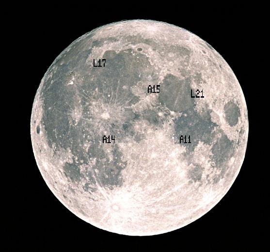
11 The Moon

12 The Moon

13 SLR stations on the world
14 Graz SLR station Laser pulse GRAZ The other stations 2 khz 5-10 Hz Energy / puls Puls width Wavelength 0.4 mj 10 ps 532 nm mj ps 532 nm High accuracy of the distance measurements 200 times more measurements per second -> POD


15 LAGEOS-1 pass
16 GPS 35: Average # of Pts/NP in 2004 Potsdam Graz Matera Grasse Riyadh Monument Wettzell Koganei Mt Stromlo McDonald Herstmonceu Yarragadee Zimmerwald Maidanak 1 Simosato Changchun Beijing Graz khz SLR - statistics
17 Graz khz SLR - calibration SLR Graz: Routine - Calibrations ; 10 Hz: 500 Returns; khz: Returns / CAL 4 Peak minus Mean [mm] CAL Peak minus Mean [mm]
18 Graz station position motion Up Component: ± 0.07 mm / year ( 100 k years until sea level) East Component: ± 0.07 mm / year North Component: ± 0.10 mm / year
19 Graz khz SLR new applications Satellite spin measurements Gravity Probe B, 650 km, 75s AJISAI, 1500 km, 2s LAGEOS 1, 2, 6000 km, 5000s, 600s ETALON 1, 2, km, 65 s Atmospheric seeing measurements monitoring the atm. condition of the way of a laser pulse Space debris tracking helps to monitor them, POD

20 Graz khz SLR Spin GP-B Lense-Thirring drag 650 km Only Graz khz SLR station was able to measure the spin of the spacecraft


21 Graz khz SLR Spin GP-B 8 CCRs, 10cm dia.


22 Graz khz SLR Spin GP-B RMS LASER-OnBoard = 0.98 s


23 Graz khz SLR Spin AJISAI Spectral analysis of khz SLR data
24 Graz khz SLR Spin AJISAI AJISAI SPIN RATE 2003/ /06; corrected for apparent Spin 195 passes with >300 k points; ± 48 s around CA used (40 k min) Spin Rate [Hz] Retro 9 Retro 12 Retro Year


25 Graz khz SLR LAGEOS-1 T=5775 s


26 Graz khz SLR ETALON-1, 2 Real obs. Sim: 30 s ~70k returns/h 66 s 100 s
27 Graz khz SLR ETALON-1, 2 Spin period of the ETALONs is increasing by a value of about 0.5 s/year RMS ~1%
28 Spin parameters - application Improving the accuracy of the perturbations models The magnetic torque ( ϖ B) Vα ( B ϖ ) B Γmagnetic = Vα ϖ B Bertotti and Iess, 1991 The gravitational torque m Γ nal = L ( C A)( 3cos ϑ )( n L)( n L) gravitatio Farinella et al., 1996 Solar radiation pressure causes a torque: I hc A c ( s r ) 0 R cross Vokrouhlicky, 1996 Γoffset = sun Bertotti, B., and Iess, L. The rotation of LAGEOS, J. Geophys. Res., 96 (B1), , 1991 Farinella, P., Vokrouhlicky, D., Barlier F. The rotation of LAGEOS and ist long-term semimajor axis decay, J. Geophys. Res., 101 (B8), 17,861-17,892, 1996 Vokrouhlicky, D. Non-gravitational effects on LAGEOS rotation. Geophys. Res. Lett., 23, , 1996

29 Graz khz SLR LAGEOS-2 Full 15 years spin period history, Only Graz khz system can measure L2 spin of more than 100s Study of various perturbations and RE

30 Graz khz SLR atm. seeing

31 Graz khz SLR seeing Laser Beam Backscatter is monitored by ISIT; => into PC; Real Time Image Processing: Determine Peak of Laser Beam; At 25 fps: Store peak coordinates in file; Post Processing: Get Area of Coordinates; FWHM of this area => Astr. Seeing (arc secs) Calibrate with standard astronomical methods
32 Graz the first khz SLR system - more accurate range measurements = improvement of POD (navigation systems HEO, LEO) - much more scientific data: spin determination of various sat. - khz SLR allows to investigate the values of the SP and their changes, that gives an unique possibility to study the tiny petrurbating forces (RE) - more information about the atmospheric conditions: seeing measurements over the station
SLR Graz: khz Satellite Laser Ranging & Co
 Graz in Space 2014 KFU Graz 4. 5. September 2014 SLR Graz: khz Satellite Laser Ranging & Co Georg Kirchner, Franz Koidl, Oliver Baur Space Research Institute Austrian Academy of Sciences Outline What is
Laser de-spin maneuver for an active debris removal mission - a realistic scenario for Envisat
 Laser de-spin maneuver for an active debris removal mission - a realistic scenario for Envisat Daniel Kucharski Space Environment Research Centre, Mt Stromlo Observatory, Weston Creek ACT, 2611, AUSTRALIA
DETERMINATION OF THE STATION COORDINATES FOR QUALITY CONTROL OF THE SATELLITE LASER RANGING DATA S.
 DETERMINATION OF THE STATION COORDINATES FOR QUALITY CONTROL OF THE SATELLITE LASER RANGING DATA S. Schillak Space Research Centre of the Polish Academy of Sciences. Astrogeodynamic Observatory, Borowiec
3.4.2 International Laser Ranging Service (ILRS)
") 3 Reports of IERS components 3.4 Technique Centres 3.4.2 International Laser Ranging Service (ILRS) Introduction Network The International Laser Ranging Service (ILRS), established in 1998, is responsible
3 Reports of IERS components 3.4 Technique Centres 3.4.2 International Laser Ranging Service (ILRS) Introduction Network The International Laser Ranging Service (ILRS), established in 1998, is responsible
INTERNATIONAL SLR SERVICE
 ARTIFICIAL SATELLITES, Vol. 46, No. 4 2011 DOI: 10.2478/v10018-012-0004-z INTERNATIONAL SLR SERVICE Stanisław Schillak Space Research Centre, Polish Academy of Sciences Astrogeodynamic Observatory, Borowiec
New satellite mission for improving the Terrestrial Reference Frame: means and impacts
 Fourth Swarm science meeting and geodetic missions workshop ESA, 20-24 March 2017, Banff, Alberta, Canada New satellite mission for improving the Terrestrial Reference Frame: means and impacts Richard
SLR-based orbit determination and orbit prediction of space debris objects
 Geodätische Woche Congress Center Essen, 8.- 10. Oktober 2013 SLR-based orbit determination and orbit prediction of space debris objects Harald Wirnsberger, Oliver Baur, Georg Kirchner Space Research Institute
Copyright 2016 Advanced Maui Optical and Space Surveillance Technologies Conference (AMOS)
") Application of satellite laser ranging techniques for space situational awareness efforts M. Shappirio, NASA Goddard Space Flight Center J.F. McGarry, NASA Goddard Space Flight Center J. Bufton, Global
Application of satellite laser ranging techniques for space situational awareness efforts M. Shappirio, NASA Goddard Space Flight Center J.F. McGarry, NASA Goddard Space Flight Center J. Bufton, Global
Torsten Mayer-Gürr Institute of Geodesy, NAWI Graz Technische Universität Graz
 GGOS and Reference Systems Introduction 2015-10-12 Torsten Mayer-Gürr Institute of Geodesy, NAWI Graz Technische Universität Graz Torsten Mayer-Gürr 1 Course and exam Lecture Monday 14:00 16:00, A111 (ST01044)
A Mission to Planet Mars Gravity Field Determination
 A Mission to Planet Mars Gravity Field Determination Department for Theoretical Geodesy Graz University of Technology and Space Research Institute Austrian Academy of Sciences Gravity field CHAMP GRACE
Assessment of the International Terrestrial Reference System 2014 realizations by Precise Orbit Determination of SLR Satellites
 Deutsches Geodätisches Forschungsinstitut (DGFI-TUM) Technische Universität München Assessment of the International Terrestrial Reference System 2014 realizations by Precise Orbit Determination of SLR
Contributions of Geodesy to Oceanography
 Contributions of Geodesy to Oceanography B. Tapley and J. Ries Center for Space Research, The University of Texas at Austin Dynamic Planet 2005 Cairns, Australia August 22-26, 2005 August 22-26, 2005 Dynam
Earth gravity field recovery using GPS, GLONASS, and SLR satellites
 Earth gravity field recovery using GPS, GLONASS, and SLR satellites Krzysztof Sośnica (1), Adrian Jäggi (1), Daniela Thaller (2), Ulrich Meyer (1), Gerhard Beutler (1), Rolf Dach (1) (1) Astronomical Institute,
Earth gravity field recovery using GPS, GLONASS, and SLR satellites
 13-01-08 Earth gravity field recovery using GPS, GLONASS, and SLR satellites Krzysztof Sośnica (1), Adrian Jäggi (1), Daniela Thaller (2), Ulrich Meyer (1), Christian Baumann (1), Rolf Dach (1), Gerhard
GG S. Internal Vision of GGOS. Markus Rothacher. GFZ Potsdam
 Internal Vision of GGOS Markus Rothacher GFZ Potsdam GGOS Retreat DGFI in Munich February 15-16, 2006 Contents Motivation Four Levels of Products of the IAG Services: First Level: Raw Data Collection Second
A method to calculate zero-signature satellite laser ranging normal points for millimeter geodesy - a case study with Ajisai
 Kucharski et al. Earth, Planets and Space (2015) 67:34 DOI 10.1186/s40623-015-0204-4 FULL PAPER A method to calculate zero-signature satellite laser ranging normal points for millimeter geodesy - a case
A TLE-BASED REPRESENTATION OF PRECISE ORBIT PREDICTION RESULTS. Jizhang Sang and Bin Li. School of Geodesy and Geomatics, Wuhan University
 A TLE-BASED REPRESENTATION OF PRECISE ORBIT PREDICTION RESULTS Jizhang Sang and Bin Li School of Geodesy and Geomatics, Wuhan University ABSTRACT The computing efficiency of the analytic SGP4 algorithm
Impact of Earth Radiation Pressure on LAGEOS Orbits and on the Global Scale
 13-Po-22 Impact of Earth Radiation Pressure on LAGEOS Orbits and on the Global Scale Krzysztof Sośnica (1), Carlos Javier Rodríguez-Solano (2), Daniela Thaller (3), Adrian Jäggi (1), Rolf Dach (1), Gerhard
P. Cipollini, H. Snaith - A short course on Altimetry. Altimetry 2 - Data processing (from satellite height to sea surface height)
") P. Cipollini, H. Snaith - A short course on Altimetry Altimetry 2 - Data processing (from satellite height to sea surface height) 1 2 Satellite height to sea surface height The altimeter measures the altitude
P. Cipollini, H. Snaith - A short course on Altimetry Altimetry 2 - Data processing (from satellite height to sea surface height) 1 2 Satellite height to sea surface height The altimeter measures the altitude
Towards an improved ILRS TRF contribution
 Towards an improved ILRS TRF contribution Erricos C. Pavlis ILRS Analysis Coordinator JCET/ & NASA Goddard IERS Workshop on Conventions 2007 20-21 Sept. 2007, Sèvres, France Overview The ILRS Network Geometry
GG S Global Geodetic Observing System (GGOS): Status and Future. Markus Rothacher, Ruth Neilan, Hans-Peter Plag
: Status and Future. Markus Rothacher, Ruth Neilan, Hans-Peter Plag") 2020 Global Geodetic Observing System (GGOS): Status and Future Markus Rothacher, Ruth Neilan, Hans-Peter Plag GeoForschungsZentrum Potsdam (GFZ) Jet Propulsion Laboratory (JPL) University of Nevada, Reno
2020 Global Geodetic Observing System (GGOS): Status and Future Markus Rothacher, Ruth Neilan, Hans-Peter Plag GeoForschungsZentrum Potsdam (GFZ) Jet Propulsion Laboratory (JPL) University of Nevada, Reno
Fundamental Station Wettzell - geodetic observatory -
 Fundamental Station Wettzell - geodetic observatory - Wolfgang Schlüter Bundesamt für Kartographie und Geodäsie, Fundamental Station Wettzell Germany Radiometer Workshop, Wettzell, 10.10.06 Evolvement
Active microwave systems (2) Satellite Altimetry * the movie * applications
 Satellite Altimetry * the movie * applications") Remote Sensing: John Wilkin wilkin@marine.rutgers.edu IMCS Building Room 211C 732-932-6555 ext 251 Active microwave systems (2) Satellite Altimetry * the movie * applications Altimeters (nadir pointing
Remote Sensing: John Wilkin wilkin@marine.rutgers.edu IMCS Building Room 211C 732-932-6555 ext 251 Active microwave systems (2) Satellite Altimetry * the movie * applications Altimeters (nadir pointing
Earth-Oriented Space Research at TU-Delft
 Earth-Oriented Space Research at TU-Delft The contribution of DEOS to the South-East Asia: Mastering Environmental Research with Geodetic Space Techniques (SEAMERGES) project Kick-off meeting, Chulalongkorn
Inertial Frame frame-dragging
 Frame Dragging Frame Dragging An Inertial Frame is a frame that is not accelerating (in the sense of proper acceleration that would be detected by an accelerometer). In Einstein s theory of General Relativity
Results and Analyses of Debris Tracking from Mt Stromlo
 Results and Analyses of Debris Tracking from Mt Stromlo Jizhang Sang 1, Ian Ritchie, Matt Pearson, and Craig Smith EOS Space Systems Pty Ltd, Australia Abstract In the last 2 years, EOS Space Systems has
HY-2A Satellite User s Guide
 National Satellite Ocean Application Service 2013-5-16 Document Change Record Revision Date Changed Pages/Paragraphs Edit Description i Contents 1 Introduction to HY-2 Satellite... 1 2 HY-2 satellite data
The JCET/GSFC (SLR) TRF Solution 2004
 TRF Solution 2004") The JCET/GSFC (SLR) TRF Solution 2004 JCET and NASA Goddard Space Flight Center Univ. of Maryland Baltimore County Baltimore, Maryland (epavlis@jcet.umbc.edu) IERS Workshop 2004: IERS Combination Pilot
The JCET/GSFC (SLR) TRF Solution 2004 JCET and NASA Goddard Space Flight Center Univ. of Maryland Baltimore County Baltimore, Maryland (epavlis@jcet.umbc.edu) IERS Workshop 2004: IERS Combination Pilot
The Global Geodetic Observing System (GGOS) of the International Association of Geodesy, IAG
 of the International Association of Geodesy, IAG") The Global Geodetic Observing System (GGOS) of the International Association of Geodesy, IAG Hans-Peter Plag (1), Markus Rothacher (2), Richard Gross (3), Srinivas Bettadpur (4) (1) Nevada Bureau of Mines
The Global Geodetic Observing System (GGOS) of the International Association of Geodesy, IAG Hans-Peter Plag (1), Markus Rothacher (2), Richard Gross (3), Srinivas Bettadpur (4) (1) Nevada Bureau of Mines
Possible advantages of equipping GNSS satellites with on-board accelerometers
 Possible advantages of equipping GNSS satellites with on-board accelerometers - a way to get profits - Maciej Kalarus (1) Krzysztof Sośnica (2) Agata Wielgosz (1) Tomasz Liwosz (3) Janusz B. Zielioski
Satellite Geodesy and Navigation Present and Future
 Satellite Geodesy and Navigation Present and Future Drazen Svehla Institute of Astronomical and Physical Geodesy Technical University of Munich, Germany Content Clocks for navigation Relativistic geodesy
Remote Sensing I: Basics
 Remote Sensing I: Basics Kelly M. Brunt Earth System Science Interdisciplinary Center, University of Maryland Cryospheric Science Laboratory, Goddard Space Flight Center kelly.m.brunt@nasa.gov (Based on
SENTINEL-3 SLR YEARLY REPORT
 SENTINEL-3 SLR YEARLY REPORT - 2017 SENTINELSPOD Prepared by: X L. J. Gallardo Project Engineer Firmado por: Luis Javier Gallardo Amézquita Approved by: X Authorised by: X J. Aguilar Quality Manager Firmado
Application of Accelerometer Data in Precise Orbit Determination of GRACE -A and -B
 Chin. J. Astron. Astrophys. Vol. 8 (28), No., 63 61 (http://www.chjaa.org) Chinese Journal of Astronomy and Astrophysics Application of Accelerometer Data in Precise Orbit Determination of GRACE -A and
Evaluation of the EGM2008 Gravity Model
 Evaluation of the EGM2008 Gravity Model Minkang Cheng, John C. Ries and Don P. Chambers Center for Space Research, University of Texas at Austin, USA 3925 West Braker Lane, STE 200, Austin, TX 78759, USA
FRENCH TRANSPORTABLE LASER RANGING STATION: POSITIONING CAMPAIGNS FOR SATELLITE ALTIMETER CALIBRATION MISSIONS IN OCCIDENTAL MEDITERRANEAN SEA
 Larhyss Journal, ISSN 1112-3680, n 12, Janvier 2013, pp. 57-69 2013 Tous droits réservés FRENCH TRANSPORTABLE LASER RANGING STATION: POSITIONING CAMPAIGNS FOR SATELLITE ALTIMETER CALIBRATION MISSIONS IN
ORBIT DETERMINATION ANALYSIS FOR A JOINT UK-AUSTRALIAN SPACE SURVEILLANCE EXPERIMENT
 ORBIT DETERMINATION ANALYSIS FOR A JOINT UK-AUSTRALIAN SPACE SURVEILLANCE EXPERIMENT M. Rutten, * T. Bessell, * N. Gordon, *, * NSID, Defence Science and Technology Organisation, Australia School of ITEE,
SECOND ANNOUNCEMENT International Technical Laser Workshop 2012 (ITLW-12)
") SECOND ANNOUNCEMENT International Technical Laser Workshop 2012 (ITLW-12) Version 31/Oct/12 Satellite, Lunar and Planetary Laser Ranging: characterizing the space segment Frascati National Laboratories
SECOND ANNOUNCEMENT International Technical Laser Workshop 2012 (ITLW-12) Version 31/Oct/12 Satellite, Lunar and Planetary Laser Ranging: characterizing the space segment Frascati National Laboratories
3.4.2 International Laser Ranging Service (ILRS)
") 3 Reports of IERS components 3.4 Technique Centres 3.4.2 International Laser Ranging Service (ILRS) Introduction Network The International Laser Ranging Service (ILRS), established in 1998, is responsible
3 Reports of IERS components 3.4 Technique Centres 3.4.2 International Laser Ranging Service (ILRS) Introduction Network The International Laser Ranging Service (ILRS), established in 1998, is responsible
A plate motion study using Ajisai SLR data
 Earth Planets Space, 50, 611 627, 1998 A plate motion study using Ajisai SLR data Arata Sengoku Hydrographic Department, Maritime Safety Agency, 5-3-1, Tsukiji, Chuo, Tokyo 104-0045, Japan (Received July
UV LED charge control at 255 nm
 UV LED charge control at 255 nm Karthik Balakrishnan Department of Aeronautics and Astronautics Hansen Experimental Physics Labs Stanford University karthikb@stanford.edu Drag free concept and applications
Development of Laser Measurement to Space Debris at Shanghai SLR Station
 Abstract Development of Laser Measurement to Space Debris at Shanghai SLR Station Zhang Zhongping, Deng Huarong, Tang Kai, Wu Zhibo, Zhang Haifeng (Shanghai Astronomical Observatory of Chinese Academy
GRACE impact in geodesy and geophysics. R. Biancale (GRGS-CNES Toulouse), M. Diament (IPG Paris)
, M. Diament (IPG Paris)") GRACE impact in geodesy and geophysics R. Biancale (GRGS-CNES Toulouse), M. Diament (IPG Paris) Improvement of gravity models Since 2002 the GRACE mission has changed some goals in geodesy. It has become
GRACE impact in geodesy and geophysics R. Biancale (GRGS-CNES Toulouse), M. Diament (IPG Paris) Improvement of gravity models Since 2002 the GRACE mission has changed some goals in geodesy. It has become
THE EARTH - GEODESY, KINEMATICS, DYNAMICS
 THE EARTH - GEODESY, KINEMATICS, DYNAMICS OUTLINE Shape: Geodetic Measurements Geodesy = science of the figure of the Earth; its relation to astronomy and the Earth s gravity field The geoid (mean sea
Probing Gravity with 2nd Generation Lunar Laser Ranging
 Probing Gravity with 2nd Generation Lunar Laser Ranging Manuele Martini (INFN-LNF) for the MoonLIGHT Collaboration D. G. Currie (PI) University of Maryland at College Park, MD, USA R. Vittori ESA-EAC Astronaut,
ACCURATE ORBIT DETERMINATION OF SPACE DEBRIS WITH LASER TRACKING
 ACCURATE ORBIT DETERMINATION OF SPACE DEBRIS WITH LASER TRACKING C. Bamann and U. Hugentobler Chair of Satellite Geodesy, Technical University of Munich, Germany, Email: christoph.bamann@tum.de, urs.hugentobler@bv.tum.de
Reduction and analysis of one-way laser ranging data from ILRS ground stations to LRO
 Reduction and analysis of one-way laser ranging data from ILRS ground stations to LRO S. Bauer 1, J. Oberst 1,2, H. Hussmann 1, P. Gläser 2, U. Schreiber 3, D. Mao 4, G.A. Neumann 5, E. Mazarico 5, M.H.
Co-location of VLBI with other techniques in space: a simulation study
 Co-location of VLBI with other techniques in space: a simulation study B. Männel, M. Rothacher ETH Zürich, Geodesy and Geodynamics Lab 7 th IGS General Meeting, Madrid 212 1 Reference frame and local ties
A new Solar Radiation Pressure Model for the GPS Satellites
 A new Solar Radiation Pressure Model for the GPS Satellites T.A. Springer, G. Beutler, M. Rothacher Astronomical Institute, University of Bern Sidlerstrasse 5, CH-32 Bern, Switzerland Abstract The largest
Gaia Astrometry Upkeeping by GNSS - Evaluation Study [GAUGES]
![Gaia Astrometry Upkeeping by GNSS - Evaluation Study [GAUGES]](/thumbs/92/109628399.jpg "Gaia Astrometry Upkeeping by GNSS - Evaluation Study [GAUGES]") Gaia Astrometry Upkeeping by GNSS - Evaluation Study [GAUGES] M. Gai, A. Vecchiato [INAF-OATo] A. Fienga, F. Vakili, J.P. Rivet, D. Albanese [OCA] Framework: Development of High Precision Astrometric Techniques
Gaia Astrometry Upkeeping by GNSS - Evaluation Study [GAUGES] M. Gai, A. Vecchiato [INAF-OATo] A. Fienga, F. Vakili, J.P. Rivet, D. Albanese [OCA] Framework: Development of High Precision Astrometric Techniques
PRECESSIONS IN RELATIVITY
 PRECESSIONS IN RELATIVITY COSTANTINO SIGISMONDI University of Rome La Sapienza Physics dept. and ICRA, Piazzale A. Moro 5 00185 Rome, Italy. e-mail: sigismondi@icra.it From Mercury s perihelion precession
1 of 5 4/21/2015 6:40 PM
 1 of 5 4/21/2015 6:40 PM 1. Which of the following lists the outer planets in order of increasing mass?,,,,,,,,,,,, 2. The surface structure of 's largest satellite, Titan, is completely unknown because
10 General Relativistic Models for Space-time Coordinates and Equations of Motion
 10 General Relativistic Models for Space-time Coordinates and Equations of Motion 10.1 Time Coordinates IAU resolution A4 (1991) set the framework presently used to define the barycentric reference system
Experimental Analysis of Low Earth Orbit Satellites due to Atmospheric Perturbations
 Experimental Analysis of Low Earth Orbit Satellites due to Atmospheric Perturbations Aman Saluja #1, Manish Bansal #2, M Raja #3, Mohd Maaz #4 #Aerospace Department, University of Petroleum and Energy
Precise Orbit Determinatibn for CHAMP'using GPS Data from BlackJack Receiver
 Precise Orbit Determinatibn for CHAMP'using GPS Data from BlackJack Receiver Da Kuang, Yoaz Bar-Sever, Willy Bertiger, Shailen Desai, Bruce Haines, Byron Iijima, Gerhard Kruizinga, Thomas'Meehan, Larry
Information in Radio Waves
 Teacher Notes for the Geodesy Presentation: Possible discussion questions before presentation: - If you didn t know the size and shape of the Earth, how would you go about figuring it out? Slide 1: Geodesy
HYPER Industrial Feasibility Study Final Presentation Orbit Selection
 Industrial Feasibility Study Final Presentation Orbit Selection Steve Kemble Astrium Ltd. 6 March 2003 Mission Analysis Lense Thiring effect and orbit requirements Orbital environment Gravity Atmospheric
QUINC2. Harvest MNPEAK MCDON4 MAZTLN HOLLAS
 Orbit analysis for the TOPEX altimeter calibration P.N.A.M. Visser 1 and C.K. Shum University of Texas at Austin Center for Space Research October 1993 Abstract Several orbits have been used in the calibration
The Effect of the Geocentric Gravitational Constant on Scale
 The Effect of the Geocentric Gravitational Constant on Scale S.Y. Zhu, F.-H. Massmann, Y. Yu, Ch. Reigber GeoForschungsZentrum Potsdam, Division 1 (Submitted to Journal of Geodesy) 1 Abstract It is well
Lecture 2 Measurement Systems. GEOS 655 Tectonic Geodesy
 Lecture 2 Measurement Systems GEOS 655 Tectonic Geodesy VLBI and SLR VLBI Very Long Baseline Interferometry SLR Satellite Laser Ranging Very Long Baseline Interferometry VLBI Geometric Delay δg S Baseline
Chapter 31 Maxwell s Equations and Electromagnetic Waves. Copyright 2009 Pearson Education, Inc.
 Chapter 31 Maxwell s Equations and Electromagnetic Waves Units of Chapter 31 Changing Electric Fields Produce Magnetic Fields; Ampère s Law and Displacement Current Gauss s Law for Magnetism Maxwell s
3. Data and analysis Introduction Data
 3. Data and analysis In every branch of knowledge the progress is proportional to the amount of facts on which to build, and therefore to the facility of obtaining data. James Maxwell 3.1. Introduction
Principles of the Global Positioning System Lecture 18" Mathematical models in GPS" Mathematical models used in GPS"
 12.540 Principles of the Global Positioning System Lecture 18" Prof. Thomas Herring" Room 54-820A; 253-5941" tah@mit.edu" http://geoweb.mit.edu/~tah/12.540 " Mathematical models in GPS" Review assignment
Improving LEO prediction precision with TLEs
 Improving LEO prediction precision with TLEs LIU Wei,WANG Ronglan,YAN Ruidong,GONG Jiancun (1. Center for Space Science and Applied Research, CAS,Beijing 119, China) Abstract: TLE is the only publicly
Status of Precise Orbit Determination for Altimeter Satellites at GSFC
 Status of Precise Orbit Determination for Altimeter Satellites at GSFC F.G. Lemoine 1, N.P. Zelensky 2, D.S. Chinn 2, B.D. Beckley 2, D.E.Pavlis 2 (1) NASA GSFC, Greenbelt, Maryland, USA (2) SGT Inc.,
Evaluation of height network in Latvia
 Evaluation of height network in Latvia Kaminskis J. (,), Balodis J. (), Janpaule I. (,), Normand M. (,), Rubans A. (), Silabriedis G. (,), Zvirgzds J. (,) AFFILIATION: () Riga Technical University; ()
New Observation Results from A Rotating-drift-scan CCD System
 New Observation Results from A Rotating-drift-scan CCD System TANG Zheng-Hong, MAO Yin-Dun, LI Yan, YU Yong Shanghai Astronomical Observatory, Chinese Academy of Sciences Abstract: A Rotating-drift-scan
Satellite and debris characterisation in LEO and GEO using adaptive optics
 Satellite and debris characterisation in LEO and GEO using adaptive optics M. Copeland, F. Bennet, F. Rigaut, C. d Orgeville and V. Korkiakoski Research School of Astronomy and Astrophysics, Australian
A new Solar Radiation Pressure Model for the GPS Satellites
 A new Solar Radiation Pressure Model for the GPS Satellites T.A. Springer, G. Beutler, M. Rothacher Astronomical Institute, University of Bern Sidlerstrasse 5, CH-3012 Bern, Switzerland Abstract The largest
A Unique Reference Frame: Basis of the Global Geodetic Observing System (GGOS) for Geodynamics and Global Change
 for Geodynamics and Global Change") SRTM (InSAR) A Unique Reference Frame: Basis of the Global Geodetic Observing System (GGOS) for Geodynamics and Global Change Hermann Drewes President IAG Commission 1 Reference Frames Deutsches Geodätisches
SRTM (InSAR) A Unique Reference Frame: Basis of the Global Geodetic Observing System (GGOS) for Geodynamics and Global Change Hermann Drewes President IAG Commission 1 Reference Frames Deutsches Geodätisches
LASER RETROREFLECTOR EXPERIMENT ON NAVSTAR 35 AND 36
 LASER RETROREFLECTOR EXPERIMENT ON NAVSTAR 35 AND 36 E. C. Pavlis Dept. of Astronomy, University of Maryland, NASA/GSFC 926 Space Geodesy Branch, Greenbelt, MD 20771 Ronald L. Beard Space Applications
Determination of long-term changes in the Earth's gravity field from satellite laser ranging observations
 JOURNAL OF GEOPHYSICAL RESEARCH, VOL. 102, NO. B10, PAGES 22,377-22,390, OCTOBER 10, 1997 Determination of long-term changes in the Earth's gravity field from satellite laser ranging observations M. K.
Consistent dynamic satellite reference frames and terrestrial geodetic datum parameters - status report PN 6 -
 Deutsches Geodätisches Forschungsinstitut (DGFI-TUM) Technische Universität München Consistent dynamic satellite reference frames and terrestrial geodetic datum parameters - status report PN 6 - Mathis
What Happened to BLITS? An Analysis of the 2013 Jan 22 Event
 What Happened to BLITS? An Analysis of the 2013 Jan 22 Event T.S. Kelso Center for Space Standards & Innovation N.N. Parkhomenko, V.D. Shargorodsky, V.P. Vasiliev, V.S. Yurasov Open Joint-Stock Company
SPIN PRECESSION IN A 2 BODY SYSTEM: A NEW TEST OF GENERAL RELATIVITY R. F. O CONNELL DEPT. OF PHYSICS & ASTRONOMY LOUISIANA STATE UNIVERSITY
 SPIN PRECESSION IN A 2 BODY SYSTEM: A NEW TEST OF GENERAL RELATIVITY R. F. O CONNELL DEPT. OF PHYSICS & ASTRONOMY LOUISIANA STATE UNIVERSITY 1 1. Newtonian Theory (p. 2) 2. General Relativistic Corrections
Thoughts on Sun-Synchronous* Altimetry
 Thoughts on Sun-Synchronous* Altimetry R. D. Ray NASA Goddard Space Flight Center 14 March 2007 * Yes, a sun-synchronous wide swath is still sun-synch! Whatʼs so bad about sun-synchronous altimetry? For
Progress Report on the WLRS: Getting ready for GGOS, LLR and Time Transfer
 13-0219 Progress Report on the WLRS: Getting ready for GGOS, LLR and Time Transfer G. Herold (1), J. Eckl (1), M. Mühlbauer (1), A. Leidig (1), J. Kodet (2), U. Schreiber (2) (1) Geodetic Observatory Wettzell,
ISSN Scientific Technical Report STR 06/01 GeoForschungsZentrum Potsdam
 ISSN 1610-0956 G F Z P EO ORSCHUNGS ENTRUM OTSDAM in der Helmholtz-Gemeinschaft Richard Biancale and Albert Bode Mean Annual and Seasonal Atmospheric Tide Models Based on 3-hourly and 6-hourly ECMWF Surface
The International Terrestrial Reference Frame. What is a Terrestrial Reference Frame?
 The International Terrestrial Reference Frame As early as the 15th century, Swedes noticed that rocks in their harbors were slowly rising out of the sea [Ekman, 1991]. These local observations were not
Robotic Lunar Exploration Scenario JAXA Plan
 Workshop May, 2006 Robotic Lunar Exploration Scenario JAXA Plan Tatsuaki HASHIMOTO JAXA 1 Question: What is Space Exploration? Answers: There are as many answers as the number of the people who answer
Hydrological balance in the large Russian river basins from GRACE satellites
 Hydrological balance in the large Russian river basins from GRACE satellites Leonid Zotov 1,2, Natalya Frolova 3, E. Kyzyngasheva 1, C.K. Shum 4,5 1 NRU Higher School of Economics, Russia 2 SAI Moscow
arxiv:gr-qc/ v1 17 Nov 2006
 International Journal of Modern Physics D c World Scientific Publishing Company arxiv:gr-qc/0611095v1 17 Nov 2006 SPACE-BASED TESTS OF GRAVITY WITH LASER RANGING SLAVA G. TURYSHEV, JAMES G. WILLIAMS Jet
Geodesy Part of the ACES Mission: GALILEO on Board the International Space Station
 Geodesy Part of the ACES Mission: GALILEO on Board the International Space Station 1 Svehla D, 2 Rothacher M, 3 Salomon C, 2 Wickert J, 2 Helm A, 2 Beyerle, G, 4 Ziebart M, 5 Dow J 1 Institute of Astronomical
1 The satellite altimeter measurement
 1 The satellite altimeter measurement In the ideal case, a satellite altimeter measurement is equal to the instantaneous distance between the satellite s geocenter and the ocean surface. However, an altimeter
Preliminary Products of Precise Orbit Determination Using Satellite Laser Ranging Observations for ILRS AAC
 Research Paper J. Astron. Space Sci. 29(3), 275-285 (2012) http://dx.doi.org/1140/jass.2012.29.3.275 Preliminary Products of Precise Orbit Determination Using Satellite Laser Ranging Observations for ILRS
THE PERTURBATION OF THE ORBITAL ELEMENTS OF GPS AND Y-BIAS. GPS satellite and each arc of one to three days on top of the a priori radiation pressure
 THE PERTURATION OF THE ORITAL ELEMENTS OF GPS SATELLITES THROUGH DIRET RADIATION PRESSURE AND Y-IAS Markus Rothacher, Gerhard eutler, Leos Mervart Astronomical Institute, University of erne H-3 ern, Switzerland
Earth rotation and Earth gravity field from GRACE observations. Lucia Seoane, Christian Bizouard, Daniel Gambis
 Earth rotation and Earth gravity field from GRACE observations Lucia Seoane, Christian Bizouard, Daniel Gambis Observatoire de Paris SYRTE, 61 av. de l'observatoire, 7514 Paris Introduction Gravity field
Integration of space and terrestrial techniques to study crustal deformation. Examples in northeastern Italy
 Integration of space and terrestrial techniques to study crustal deformation. Examples in northeastern Italy Susanna Zerbini Dipartimento di Fisica, University of Bologna, Italy IAG-IASPEI Joint Capacity
Measuring the Whirling of Spacetime
 Measuring the Whirling of Spacetime Lecture series on Experimental Gravity (revised version) Kostas Glampedakis Prologue: does spin gravitate? M 1 M 2 System I: F = GM 1M 2 r 2 J 1 J 2 System II: M 1?
Science Unit Test Grade: 8 Unit 6: Gravity
 Science Unit Test Grade: 8 Unit 6: Gravity Name Date 1. Which of these is best used to measure weight in newtons? a. Spring scale b. Triple beam balance c. Double pan balance d. Simple lever 2. Which of
Spacecraft Bus / Platform
 Spacecraft Bus / Platform Propulsion Thrusters ADCS: Attitude Determination and Control Subsystem Shield CDH: Command and Data Handling Subsystem Payload Communication Thermal Power Structure and Mechanisms
Table 5-1: POD Processing Overview
 38 of 141 5. ORBITAL ACCURACY This section reports on the orbital accuracy attainable by the Copernicus POD Service with the current system. In order to perform an external validation of the orbital products,
Status of the Gravitational Redshift Test with Eccentric Galileo Satellites
 Status of the Gravitational Redshift Test with Eccentric Galileo Satellites J. Ventura-Traveset, R. Prieto-Cerdeira, D. Blonski ICG 11, Sochi, 7 November 2016 Contents 1. Galileo satellites 5 & 6 Status
The Orbit Control of ERS-1 and ERS-2 for a Very Accurate Tandem Configuration
 The Orbit Control of ERS-1 and ERS-2 for a Very Accurate Tandem Configuration Mats Rosengren European Space Operations Centre Robert Bosch Str 5 D64293 Darmstadt Germany Email: mrosengr@esoc.esa.de Abstract
ON THE ACCURACY OF CURRENT MEAN SEA SURFACE MODELS FOR THE USE WITH GOCE DATA
 ON THE ACCURACY OF CURRENT MEAN SEA SURFACE MODELS FOR THE USE WITH GOCE DATA Ole B. Andersen 1, M-.H., Rio 2 (1) DTU Space, Juliane Maries Vej 30, Copenhagen, Denmark (2) CLS, Ramon St Agne, France ABSTRACT
A Factor of 2-4 Improvement in Marine Gravity and Predicted Bathymetry from CryoSat, Jason-1, and Envisat Radar Altimetry: Arctic and Coastal Regions
 DISTRIBUTION STATEMENT A. Approved for public release; distribution is unlimited. A Factor of 2-4 Improvement in Marine Gravity and Predicted Bathymetry from CryoSat, Jason-1, and Envisat Radar Altimetry:
Third Body Perturbation
 Third Body Perturbation p. 1/30 Third Body Perturbation Modeling the Space Environment Manuel Ruiz Delgado European Masters in Aeronautics and Space E.T.S.I. Aeronáuticos Universidad Politécnica de Madrid
Development of a new SSA facility at Learmonth Australia
 Development of a new SSA facility at Learmonth Australia Craig H. Smith EOS Space Systems Ben Greene Electro Optic Systems EOS Space Systems Matt Bold Lockheed Martin Corporation Rod Drury Lockheed Martin
on space debris objects obtained by the
 KIAM space debris data center for processing and analysis of information on space debris objects obtained by the ISON network Vladimir Agapov, Igor Molotov Keldysh Institute of Applied Mathematics RAS
Modern Navigation. Thomas Herring
 12.215 Modern Navigation Thomas Herring Today s Class Latitude and Longitude Simple spherical definitions Geodetic definition: For an ellipsoid Astronomical definition: Based on direction of gravity Relationships