The International Terrestrial Reference Frame. What is a Terrestrial Reference Frame?
|
|
|
- Leona Holmes
- 6 years ago
- Views:
Transcription
1 The International Terrestrial Reference Frame As early as the 15th century, Swedes noticed that rocks in their harbors were slowly rising out of the sea [Ekman, 1991]. These local observations were not sufficient to distinguish whether the rocks were rising or the sea level falling. Later, it was realized that Fennoscandia was still rebounding from the last Ice Age. This historical observation is still relevant today. How can you know whether a point on the Earth's surface is slowly moving up, down, or horizontally? One must relate local measurements to a stable and accurate reference frame, one whose scale is much larger than the problem at hand. We remain concerned with sea level variations, but present-day studies recognize that change must be measured from a global point of view and with respect to a globally well-defined reference frame. Thus, the regional and national geodetic datums developed over the past 200 years are inappropriate for studying global-level problems. One of the main tasks of modern geodesy --the science of measuring and mapping the Earth's surface-- is to define and maintain this global terrestrial reference frame. How well the reference frame can be realized has important implications for our ability to study both regional and global properties of the Earth, including post-glacial rebound, sea level change, plate tectonics, regional subsidence and loading, plate boundary deformation, and Earth orientation excitation. What is a Terrestrial Reference Frame? Two coordinate frames are commonly used: a rotating system fixed to the Earth's surface (terrestrial; used for most practical applications) and an essentially inertial system fixed to the stars (celestial; where dynamical equations of motion can be solved). The celestial reference frame was historically specified by the equator, ecliptic, and pole of rotation of the Earth and was realized by the two-dimensional coordinates of a large number of stars. The present-day International Celestial Reference Frame (ICRF) is defined by the coordinates of a much smaller set of essentially stationary quasars whose positions are far better known. The terrestrial reference frame, on the other hand, was realized mostly through national conventions. In 1895, the International Latitude Service (ILS) formed, marking the development of the first international group of globally distributed stations to define and monitor the evolution of the frame. In 1962, this group evolved into the much broader International Polar Motion Service (IPMS). The establishment of the International Earth Rotation Service (IERS) in 1988 shifted the responsibility for establishing and maintaining both frames to a single international authority. This was the genesis of the International Terrestrial Reference Frame (ITRF). In a break with the past, IERS based its definition of the ITRF and ICRF on modern observational techniques: Doppler and laser tracking of satellites, very long baseline interferometry (VLBI) astrometry and later global positioning system (GPS) tracking. Although far more accurate than classical techniques, none of these techniques is sensitive to all degrees of freedom--translational, rotational, and scale--of a reference frame. We thus need to use the relevant information from each to define the frame in its entirety. Since one of the primary reasons behind establishing a unique global reference frame is to provide a common reference in comparing observations and results from different locations and epochs, "continuity" between the older realizations and the new ones is
2 of utmost importance. Thus, it is not by chance that while the new frames do not rely on astronomical observations, the Greenwich meridian is still used as the "primary meridian" containing the x and z axes of the ITRF. Similarly, the z-axis is defined to coincide with the Conventional International Origin (CIO), which was defined by ILS as the mean pole of rotation over the period To relate the celestial and terrestrial reference frames, knowledge of the Earth's variable rotation vector in space is required. This includes motions with respect to both inertial space and the crust. Earth orientation variations, particularly those with respect to the crust, cannot be accurately predicted. Developments in space geodetic techniques over the past 2 decades now allow these processes to be monitored at a level comparable to the accuracy of the terrestrial and celestial frame realizations. IERS coordinates the programs to monitor the Earth orientation parameters that relate the ICRF and ITRF. How Is the ITRF Formed? The ITRF is realized through the global Cartesian coordinates and linear velocities of a global set of sites equipped with various space geodetic observing systems, and it is maintained by participating agencies (Figure 1). It is assembled by combining sets of results from independent techniques as analyzed by a number of separate groups organized under the IERS and cooperating services. The space geodetic techniques used at present are lunar and satellite laser ranging (LLR, SLR), VLBI, GPS, and Doppler orbit determination and radio positioning integrated on satellites (DORIS). Each technique is organized as a service by the International Association of Geodesy. In addition to these observations, the frame also depends on the surveyed tie vectors that relate colocated systems at a subset of the ITRF sites. Without these ties, each geodetic technique would realize individual terrestrial frames rather than a single unified one. The complementarity of the independent techniques used by the IERS requires an integrated approach to achieve the highest possible accuracy and consistency for the ITRF. All techniques can contribute to the ITRF, given appropriate weights and allowing for possible systematic differences. The advantage of using as many different techniques and solutions as possible is that the errors of the combined ITRF can be significantly smaller than for any of the individual contributors, if the error sources are largely independent. This also improves stability from one ITRF realization to the next and improves reliability. However, it is expected that in many cases the dominant errors in individual solutions will be mainly systematic rather than random. This can make the determination of appropriate solution weights problematic. Since the ITRF should be as accurate as possible, and not merely stable from one realization to the next, care must be taken to ensure that the effects of systematic errors are identified and controlled as much as possible. Beginning with the ITRF94 realization, only those reference frame solutions that provide full variance-covariance information accompanied by complete a priori constraint matrices are used. In this way, the ITRF is formed and maintained in a rigorous fashion. Alignments in orientation between successive updates rely on the full covariance information, which is also provided to the user community with the site coordinates and velocities. Unlike some of the older terrestrial reference frames, the ITRF allows for the relative motions of sites on the Earth's surface, due to plate tectonics as well as other local effects. These observations
3 of contemporary motions can be compared to plate motion models, which are based on geological data spanning the past 3 million years. Outside of plate boundary deformation zones, the rates generally agree very well. Difficulties do arise in certain cases, particularly when a station's motion is not at a constant velocity. Position offsets can be introduced to account for episodic events such as earthquakes, but the assumption of constant velocities is not always adequate for describing post-seismic motions. Such situations must be treated as special cases. Evolution of the ITRF to Present: ITRF2000 Space geodesy at the sub-decimeter level began with SLR and VLBI in the 1970s, and it benefited particularly from the vigorous support of NASA's Crustal Dynamics Program. The first detection of contemporary intercontinental plate motion was one product of this program. In the mid-1980s, GPS began to be used for regional crustal deformation measurements, expanding quickly to form a global network of continuously operating receivers by the early 1990s. DORIS, which was accepted as an IERS technique in the mid-1990s and first used in the ITRF94 realization, enjoys an especially robust network of globally well-distributed sites. The work of combining contributed sets of coordinates and velocities from the various techniques and analyses is performed by the IERS Terrestrial Reference System Product Center, which is hosted by the Institut Géographique National in Paris. The first ITRF realization was prepared shortly after the founding of IERS in In the past decade, a new ITRF has been prepared approximately every 2 years. In March of 2001, ITRF2000 was released. The locations of the ITRF2000 sites are shown in Figure 2; sites where collocated techniques are operating, such as shown in Figure 1, are also highlighted. ITRF2000 is the most extensive and accurate terrestrial reference frame ever developed and includes positions and velocities for about 800 stations located at about 500 sites. As stated above, a terrestrial reference frame requires the definition of its scale, its origin, and the orientation of the coordinate axes. The sensitivities of some techniques are better suited for observing certain aspects of the frame. For example, the scale of ITRF2000 was established by a combination of VLBI and SLR results. The orientation of the frame has been aligned with the preceding realization, ITRF97, and its orientation rate is defined, by convention, so that there is no net rotation of the frame with respect to the Earth's lithosphere. To do so, the ITRF2000 orientation rate is aligned to the geological tectonic model NNR-NUVEL-1A [Argus and Gordon, 1991]. Clearly many of the sites in Figure 2 are in plate boundary zones and thus were not used to specify the no-net-rotation condition. Sites whose velocities showed significant discrepancies with respect to NNR-NUVEL-1A or were observed only briefly were also removed from the rotational constraint. In addition to the rotational definition, the translational origin must also be precisely defined and maintained. For the ITRF, the origin is chosen to be the center of mass of the Earth, which is determined by the mass distribution of the solid Earth (including the Earth's interior), the oceans, and the atmosphere. This is the point about which a satellite dynamically orbits, although the tracking sites are all located on the lithosphere only, and so the network origin will not generally coincide with the center of mass [Watkins and Eanes, 1997]. ITRF2000 uses SLR tracking of the Lageos spacecraft to determine the translational origin of the reference frame. Only the linear
4 evolution of the geocenter is currently modeled, but future realizations may include periodic variations as well. A strength of ITRF2000 is its combination of station positions and velocities that are free from any external constraint, thus reflecting the actual precision of the space geodetic techniques. Although GPS was not used in the ITRF2000 origin or scale definition, it makes a large contribution in terms of the velocity field (about 150 IGS stations, as well as many regional GPS networks). DORIS, with its homogeneous network coverage, provides an excellent tracking system for low Earth orbiting satellites. Based on the internal consistency of the independent solutions included in ITRF2000, the global frame scale and origin stability over 10 years is estimated to be accurate in scale to better than 0.5 parts per billion. This is equivalent to a shift of about 3 mm in station height and better than 4 mm in origin. Maintenance and improvement of a global frame of this accuracy requires continued collection of high-quality geodetic data. How is a Reference Frame Used by Scientists? Space geodesy is used to investigate a wide range of scientific questions and applications, particularly those related to crustal motions and the rotational dynamics of the Earth. In addition to the well-known tectonic deformations being monitored by space geodetic techniques, there are other geodynamic processes that are also measurable with space geodesy, including mantle elasticity and viscosity, structure and properties of the core and core-mantle boundary, and variations in water storage. In many cases, the surface expression of these processes can be less than 1 mm/yr. Current space geodetic technology is capable of measuring these rates, but only with fairly lengthy observation campaigns, ~5-15 years. To achieve the highest accuracy possible, the reference frame must be consistently defined throughout this observation period. The recent space geodetic studies of post-glacial rebound [Argus et al., 1999; Johansson et al., 2001] are just a few examples in which millimeter-per-year level vertical results depend heavily on the accuracy and stability of the terrestrial reference frame. It is straightforward to see how measuring positions on the Earth's surface--given enough time--will provide the kinematic expression needed to study the dynamics of Earth deformation. What is perhaps less appreciated is how important the terrestrial reference frame is to other scientific experiments. One example is Topex/Poseidon, which uses SLR and DORIS as its primary tracking systems. Assessments of sea level rise derived from Topex/Poseidon studies directly benefit from accurate ITRF coordinates being used for the SLR and DORIS tracking sites. Likewise, the upcoming JASON-1 radar altimeter mission, the Gravity Recovery and Climate Experiment (GRACE) mission to measure the Earth's time variable gravity, and the ICESat mission to measure ice sheet elevation all require orbits that are accurately referenced to the Earth at the centimeter level, which in turn requires the precise reference frame that the ITRF provides. The precise orbit knowledge required by these missions is a critical prerequisite to their ability to significantly contribute to hydrology, oceanography, and glaciology. Perspective It is easy to overlook the importance of the terrestrial reference frame and take for granted that a well-determined frame will always be available. However, a considerable amount of analysis from
5 a variety of institutions around the world is required to determine and maintain the modern terrestrial reference frame. This effort takes place quietly in the background but is nonetheless critical for much of today's high-accuracy geodesy-based results. Each technique brings unique contributions, and the past few decades have been devoted to improving the quality of the data and the analysis methods. As we approach, and hope to exceed, the part-per-billion level in knowledge of the Earth's shape, the importance of continuing the support of each of these techniques cannot be underestimated. Returning to our initial example, when we ask whether a tide gauge is sinking or the sea level is rising, and we want to know this better than the few millimeter-per-year level, only an accurate, stable global terrestrial reference frame will give the answer. For more information on space geodesy and reference frames refer to: International Terrestrial Reference Frame, ITRF ( International Earth Rotation Service, IERS ( International GPS Service, IGS ( International VLBI Service for Geodesy and Astrometry ( International DORIS Service, IDS ( and International Laser Ranging Service, ILRS ( Acknowledgments The ITRF Working Group thanks the many institutions and individuals that contributed to ITRF2000 ( We also thank Wolfgang Schlüter for providing Figure 1 and Duncan Agnew for reviewing the article. Authors Zuheir Altamimi, Detlef Angermann, Don Argus, Geoff Blewitt, Claude Boucher, Ben Chao, Hermann Drewes, Richards Eanes, Martine Feissel, Remi Ferland, Tom Herring, Bill Holt, Jan Johannson, Kristine Larson, Chopo Ma, John Manning, Chuck Meertens, Axel Nothnagel, Erricos Pavlis, Gerard Petit, Jim Ray, John Ries, Hans-Georg Scherneck, Patrick Sillard, and Mike Watkins. For additional information, contact Kristine Larson, Chair, ITRF Working Group, Department of Aerospace Engineering Sciences, University of Colorado, Boulder, Colo., USA; E- mail: kristine.larson@colorado.edu References Argus, D., and R. Gordon, No-net rotation model of current plate velocities incorporating plate motion model NUVEL-1, Geophys. Res. Lett., 18, , Argus, D. F., W. R. Peltier, and M. M. Watkins, Global Isostatic Adjustment Observed Using Very Long Baseline Interferometry and Satellite Laser Ranging, J. Geophys. Res., 104, 29,077-29,083, Ekman, M., A concise history of postglacial land uplift research (from its beginning to 1950), Terra Nova, 3, , 1991.
6 Johansson, J. M., et al., Continuous GPS measurements of postglacial adjustment in Fennoscandia, 1. Geodetic results, J. Geophys. Res., in press, Watkins, M. M., and R. J. Eanes, Observations of Tidally Coherent Variations in the Geocenter, Geophys. Res. Lett., 24, , Figure Captions Fig. 1. ITRF sites in Wettzell, Germany, with GPS in the foreground, and SLR and VLBI in the background. Fig. 2. Location of geodetic sites defined in ITRF2000.

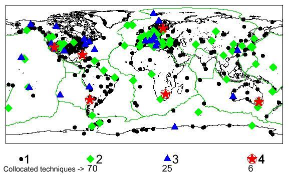
7 Figure 1 Figure 2
New satellite mission for improving the Terrestrial Reference Frame: means and impacts
 Fourth Swarm science meeting and geodetic missions workshop ESA, 20-24 March 2017, Banff, Alberta, Canada New satellite mission for improving the Terrestrial Reference Frame: means and impacts Richard
Publ. Astron. Obs. Belgrade No. 91 (2012), REALIZATION OF ETRF2000 AS A NEW TERRESTRIAL REFERENCE FRAME IN REPUBLIC OF SERBIA
, REALIZATION OF ETRF2000 AS A NEW TERRESTRIAL REFERENCE FRAME IN REPUBLIC OF SERBIA") Publ. Astron. Obs. Belgrade No. 91 (2012), 199-206 Contributed paper REALIZATION OF ETRF2000 AS A NEW TERRESTRIAL REFERENCE FRAME IN REPUBLIC OF SERBIA D. BLAGOJEVIĆ and V. VASILIĆ Faculty of Civil Engineering,
Publ. Astron. Obs. Belgrade No. 91 (2012), 199-206 Contributed paper REALIZATION OF ETRF2000 AS A NEW TERRESTRIAL REFERENCE FRAME IN REPUBLIC OF SERBIA D. BLAGOJEVIĆ and V. VASILIĆ Faculty of Civil Engineering,
The Global Geodetic Observing System (GGOS) of the International Association of Geodesy, IAG
 of the International Association of Geodesy, IAG") The Global Geodetic Observing System (GGOS) of the International Association of Geodesy, IAG Hans-Peter Plag (1), Markus Rothacher (2), Richard Gross (3), Srinivas Bettadpur (4) (1) Nevada Bureau of Mines
The Global Geodetic Observing System (GGOS) of the International Association of Geodesy, IAG Hans-Peter Plag (1), Markus Rothacher (2), Richard Gross (3), Srinivas Bettadpur (4) (1) Nevada Bureau of Mines
Contributions of Geodesy to Oceanography
 Contributions of Geodesy to Oceanography B. Tapley and J. Ries Center for Space Research, The University of Texas at Austin Dynamic Planet 2005 Cairns, Australia August 22-26, 2005 August 22-26, 2005 Dynam
From Global to National Geodetic Reference Frames: how are they connected and why are they needed?
 From Global to National Geodetic Reference Frames: how are they connected and why are they needed? Zuheir ALTAMIMI Institut National de l Information Géographique et Forestière, France Vice-President,
Towards a Rigorous Combination of Space Geodetic Techniques
 Towards a Rigorous Combination of Space Geodetic Techniques Markus Rothacher Forschungseinrichtung Satellitengeodäsie, TU Munich, Germany Abstract: The with all its different components and products, ranging
Geodetic Observing Systems: tools in observing the Glacial Isostatic Adjustment. Markku Poutanen Finnish Geodetic Institute
 Geodetic Observing Systems: tools in observing the Glacial Isostatic Adjustment Markku Poutanen Finnish Geodetic Institute Glacial Isostatic Adjustment Land uplift is just one consequence of the physical
Memo : Specifications for reference frame fixing in the analysis of a EUREF GPS campaign
 ' ' 7 7 7 6 6 ' Memo : Specifications for reference frame fixing in the analysis of a EUREF GPS campaign Version 1 : 30-09-1993 Version 2 : 07-03-1995 Version 3 : 10-02-1997 Version 4 : 0-01-199 Version
Lecture 2 Measurement Systems. GEOS 655 Tectonic Geodesy
 Lecture 2 Measurement Systems GEOS 655 Tectonic Geodesy VLBI and SLR VLBI Very Long Baseline Interferometry SLR Satellite Laser Ranging Very Long Baseline Interferometry VLBI Geometric Delay δg S Baseline
Torsten Mayer-Gürr Institute of Geodesy, NAWI Graz Technische Universität Graz
 GGOS and Reference Systems Introduction 2015-10-12 Torsten Mayer-Gürr Institute of Geodesy, NAWI Graz Technische Universität Graz Torsten Mayer-Gürr 1 Course and exam Lecture Monday 14:00 16:00, A111 (ST01044)
Application of Satellite Laser Ranging for Long- Wavelength Gravity Field Determination
 Application of Satellite Laser Ranging for Long- Wavelength Gravity Field Determination J. C. Ries Center for Space Research The University of Texas at Austin Low Degree Gravity Variations from SLR GRACE
Introduction to geodetic VLBI
 Introduction to geodetic VLBI David Mayer Andreas Hellerschmied Johannes Böhm Harald Schuh and Johannes Böhm, Very Long Baseline Interferometry for Geodesy and Astrometry, in Guochang Xu (editor): Sciences
Role and importance of the International Terrestrial Reference Frame for sustainable development
 Role and importance of the International Terrestrial Reference Frame for sustainable development This report is provided for the benefit of participants of the UNRCC-PCGIAP Informal Geodetic Consultation,
Common Realization of Terrestrial and Celestial Reference Frame
 Common Realization of Terrestrial and Celestial Reference Frame M. Seitz, R. Heinkelmann, P. Steigenberger, T. Artz Abstract The realization of the International Celestial Reference System (ICRS) and the
Frames for the Future New Datum Definitions for Modernization of the U.S. National Spatial Reference System
 Figure 10. Horizontal position differences (in meters) between NAD 83 and ITRF 08 at time 2022.00 (January 1, 2022). Positional differences are shown for the North American and Pacific tectonic plates.
Global reference systems and Earth rotation
 current realizations and scientific problems Aleksander Brzeziński 1,2, Tomasz Liwosz 1, Jerzy Rogowski 1, Jan Kryński 3 1 Department of Geodesy and Geodetic Astronomy Warsaw University of Technology 2
Update on the International Terrestrial Reference Frame (ITRF) : ITRF2014. Zuheir Altamimi
 : ITRF2014. Zuheir Altamimi") Update on the International Terrestrial Reference Frame (ITRF) : ITRF2014 Zuheir Altamimi Head of the IERS ITRF Product Center IAG Vice President IGN, France E-mail: zuheir.altamimi@ign.fr Key Points Introduction:
Update on the International Terrestrial Reference Frame (ITRF) : ITRF2014 Zuheir Altamimi Head of the IERS ITRF Product Center IAG Vice President IGN, France E-mail: zuheir.altamimi@ign.fr Key Points Introduction:
Challenges and Perspectives for TRF and CRF Determination
 , IVS 2012 General Meeting Proceedings, p.309 313 http://ivscc.gsfc.nasa.gov/publications/gm2012/boehm.pdf Johannes Böhm 1, Zinovy Malkin 2, Sebastien Lambert 3, Chopo Ma 4 1) Vienna University of Technology
Call for space geodetic solutions corrected for non-tidal atmospheric loading (NT-ATML) at the observation level
 at the observation level") Call for space geodetic solutions corrected for non-tidal atmospheric loading (NT-ATML) at the observation level Xavier Collilieux, Tonie van Dam, Zuheir Altamimi Outline: Context Why correcting for non-tidal
Call for space geodetic solutions corrected for non-tidal atmospheric loading (NT-ATML) at the observation level Xavier Collilieux, Tonie van Dam, Zuheir Altamimi Outline: Context Why correcting for non-tidal
A Unique Reference Frame: Basis of the Global Geodetic Observing System (GGOS) for Geodynamics and Global Change
 for Geodynamics and Global Change") SRTM (InSAR) A Unique Reference Frame: Basis of the Global Geodetic Observing System (GGOS) for Geodynamics and Global Change Hermann Drewes President IAG Commission 1 Reference Frames Deutsches Geodätisches
SRTM (InSAR) A Unique Reference Frame: Basis of the Global Geodetic Observing System (GGOS) for Geodynamics and Global Change Hermann Drewes President IAG Commission 1 Reference Frames Deutsches Geodätisches
Fundamental Station Wettzell - geodetic observatory -
 Fundamental Station Wettzell - geodetic observatory - Wolfgang Schlüter Bundesamt für Kartographie und Geodäsie, Fundamental Station Wettzell Germany Radiometer Workshop, Wettzell, 10.10.06 Evolvement
Principles of the Global Positioning System Lecture 18" Mathematical models in GPS" Mathematical models used in GPS"
 12.540 Principles of the Global Positioning System Lecture 18" Prof. Thomas Herring" Room 54-820A; 253-5941" tah@mit.edu" http://geoweb.mit.edu/~tah/12.540 " Mathematical models in GPS" Review assignment
Very Long Baseline Interferometry for Geodesy and Astrometry
 VieVS User-Workshop 2017 Very Long Baseline Interferometry for Geodesy and Astrometry Johannes Böhm VLBI How does it work? VLBI a flowchart SINEX skd vex2 drudge drudge snp/prc snp/prc NGS Mark4 Mark4
The Kinematic Reference Frame for ITRF
 The Kinematic Reference Frame for ITRF Hermann Drewes and Barbara Meisel Deutsches Geodätisches Forschungsinstitut Munich, Germany IERS Workshop, Potsdam, 10.10.2005 Motivation and Objectives The kinematic
The International Terrestrial Reference System and ETRS89: Part I : General concepts
 The International Terrestrial Reference System and ETRS89: Part I : General concepts Zuheir ALTAMIMI Laboratoire de Recherche en Géodésie Institut national de l information géographique et forestière (IGN),
The Global Geodetic Observing System (GGOS) of the International Association of Geodesy (IAG)
 of the International Association of Geodesy (IAG)") The Global Geodetic Observing System (GGOS) of the International Association of Geodesy (IAG) Hermann Drewes Representative of the International Union of Geodesy and Geophysics (IUGG) to the Cartographic
The Global Geodetic Observing System (GGOS) of the International Association of Geodesy (IAG) Hermann Drewes Representative of the International Union of Geodesy and Geophysics (IUGG) to the Cartographic
E. Calais Purdue University - EAS Department Civil 3273
 E. Calais urdue University - EAS Department Civil 3273 ecalais@purdue.edu Need for a Reference Frame 1. ositions and velocities from geodetic measurements: Are not direct observations, but estimated quantities
Originally published as:
 Originally published as: Seitz M., Steigenberger P., Artz T. (2xx) Consistent adjustment of combined terrestrial and celestial reference frames, Earth on the Edge: Science for a Sustainable Planet, IAG
Preparation for the ITRF2013. Zuheir Altamimi Xavier Collilieux Laurent Métivier IGN, France
 Preparation for the ITRF2013 Zuheir Altamimi Xavier Collilieux Laurent Métivier IGN, France 1 Outline Introduction Solicited solutions Analysis Strategy Preparation for the ITRF2013: Combination tests
GGOS INFORMATION MODELS: ANALYSIS OF INTERRELATIONS BETWEEN OBSERVATION TECHNIQUES AND THE EARTH GRAVITY FIELD
 GGOS INFORMATION MODELS: ANALYSIS OF INTERRELATIONS BETWEEN OBSERVATION TECHNIQUES AND THE EARTH GRAVITY FIELD Wojciech Pachelski 1) Małgorzata Paśnicka-Pawłowska 2) Karolina Szafranek 3) Agnieszka Zwirowicz
Towards an improved ILRS TRF contribution
 Towards an improved ILRS TRF contribution Erricos C. Pavlis ILRS Analysis Coordinator JCET/ & NASA Goddard IERS Workshop on Conventions 2007 20-21 Sept. 2007, Sèvres, France Overview The ILRS Network Geometry
GG S. Internal Vision of GGOS. Markus Rothacher. GFZ Potsdam
 Internal Vision of GGOS Markus Rothacher GFZ Potsdam GGOS Retreat DGFI in Munich February 15-16, 2006 Contents Motivation Four Levels of Products of the IAG Services: First Level: Raw Data Collection Second
Geodetic Very Long Baseline Interferometry (VLBI)
") Geodetic Very Long Baseline Interferometry (VLBI) A brief Note compiled by: Prof. Madhav N. Kulkarni, IIT Bombay Since the inception of the Very Long Baseline Interferometry (VLBI) system in 1967, this
Geodetic Very Long Baseline Interferometry (VLBI) A brief Note compiled by: Prof. Madhav N. Kulkarni, IIT Bombay Since the inception of the Very Long Baseline Interferometry (VLBI) system in 1967, this
ITRF2014 Et la prise en compte des mouvements non linéaires
 ITRF2014 Et la prise en compte des mouvements non linéaires Zuheir Altamimi, Paul Rebischung, Laurent Métivier, Xavier Collilieux E-mail: zuheir.altamimi@ign.fr ITRF2014 Network Key Points Modelling of
A Strategic Plan for Geodesy in Sweden. Mikael Lilje Lars E. Engberg Geodesy Department Lantmäteriet Sweden
 A Strategic Plan for Geodesy in Sweden Mikael Lilje Lars E. Engberg Geodesy Department Lantmäteriet Sweden Our vision is to be able to meet Swedish society s needs for a homogeneous, sustainable geodetic
IGS POLAR MOTION MEASUREMENTS
 STATUS & PROSPECTS FOR IGS POLAR MOTION MEASUREMENTS Why does the IGS care about EOPs? observations, predictions, & IGS product table Recent pole & pole rate accuracies & error sources Rapid & Final products
Very Long Baseline Interferometry for Geodesy and Astrometry
 Very Long Baseline Interferometry for Geodesy and Astrometry Johannes Böhm Harald Schuh and Johannes Böhm, Very Long Baseline Interferometry for Geodesy and Astrometry, in Guochang Xu (editor): Sciences
The International Terrestrial Reference System and ETRS89: Part II : ITRS & ETRS89 relationship
 The International Terrestrial Reference System and ETRS89: Part II : ITRS & ETRS89 relationship Zuheir ALTAMIMI Laboratoire de Recherche en Géodésie Institut national de l information géographique et forestière
EUREF Technical Note 1: Relationship and Transformation between the International and the European Terrestrial Reference Systems
 EUREF Technical Note 1: Relationship and Transformation between the International and the European Terrestrial Reference Systems Zuheir Altamimi Institut National de l Information Géographique et Forestière
GEOS 655 Tectonic Geodesy. Jeff Freymueller Elvey 413B, x7286
 GEOS 655 Tectonic Geodesy Jeff Freymueller jfreymueller@alaska.edu Elvey 413B, x7286 Application of Geodesy to Tectonics Uncertainties < 1 mm/y Blue: stable part of tectonic plates Red: deforming zones
Current status of the ITRS realization
 Current status of the ITRS realization Input data Principles for datum definition Combination strategies (3 CCs) Some notes on ITRF2005 Next ITRF solution (?) Zuheir Altamimi ITRS PC ITRF Input Data Up
SIRGAS: Basis for Geosciences, Geodata, and Navigation in Latin America
 SIRGAS: Basis for Geosciences, Geodata, and Navigation in Latin America Claudio Brunini President of SIRGAS Universidad Nacional de La Plata, Argentina María Virginia Mackern President of SIRGAS/WG-I:
Frequent epoch reference frames instead of instant station positions and constant velocities
 Deutsches Geodätisches Forschungsinstitut Technische Universität München (DGFI-TUM) Frequent epoch reference frames instead of instant station positions and constant velocities Hermann Drewes Deutsches
INTERNATIONAL SLR SERVICE
 ARTIFICIAL SATELLITES, Vol. 46, No. 4 2011 DOI: 10.2478/v10018-012-0004-z INTERNATIONAL SLR SERVICE Stanisław Schillak Space Research Centre, Polish Academy of Sciences Astrogeodynamic Observatory, Borowiec
Time-variable gravity from SLR and DORIS tracking
 Time-variable gravity from SLR and DORIS tracking Frank G. Lemoine 1, Steven M. Klosko 2, Christopher M. Cox 3, Thomas J. Johnson 4 1. Planetary Geodynamics Laboratory, NASA Goddard Space Flight Center,
GGOS The Global Geodetic Observing System of the International Association of Geodesy (IAG)
") GGOS The Global Geodetic Observing System of the International Association of Geodesy (IAG) Hansjörg KUTTERER, Germany Key words: Geodetic Reference Frames, Global Geodetic Observing System, International
GGOS The Global Geodetic Observing System of the International Association of Geodesy (IAG) Hansjörg KUTTERER, Germany Key words: Geodetic Reference Frames, Global Geodetic Observing System, International
3.3 Analysis Coordinator
 1. Introduction 2. Analysis of ITRF2014 post-seismic parameterization In this report we outline the activities of the Analysis Coordinator during 2015. The main activities were analysis of the ITRF2014
El proyecto Sistema de Observación Geodésico Global [Global Geodetic Observing System (GGOS)] de la Asociación Internacional de Geodesia (IAG)
![El proyecto Sistema de Observación Geodésico Global [Global Geodetic Observing System (GGOS)] de la Asociación Internacional de Geodesia (IAG)](/thumbs/79/79010389.jpg "El proyecto Sistema de Observación Geodésico Global [Global Geodetic Observing System (GGOS)] de la Asociación Internacional de Geodesia (IAG)") El proyecto Sistema de Observación Geodésico Global [Global Geodetic Observing System (GGOS)] de la Asociación Internacional de Geodesia (IAG) Hermann Drewes Deutsches Geodätisches Forschungsinstitut (DGFI)
El proyecto Sistema de Observación Geodésico Global [Global Geodetic Observing System (GGOS)] de la Asociación Internacional de Geodesia (IAG) Hermann Drewes Deutsches Geodätisches Forschungsinstitut (DGFI)
GGOS, ECGN and NGOS: Global and regional geodetic observing systems. Markku Poutanen Finish Geodetic Institute
 GGOS, ECGN and NGOS: Global and regional geodetic observing systems Markku Poutanen Finish Geodetic Institute Contents GGOS, ECGN, NGOS Why? How? Future? (geodesy) GGOS Structure GGOS Structure European
Actual Continuous Kinematic Model (ACKIM) of the Earth s Crust based on ITRF2014
 of the Earth s Crust based on ITRF2014") Actual Continuous Kinematic Model (ACKIM) of the Earth s Crust based on ITRF2014 Hermann Drewes Technische Universität München Joint Scientific Assembly of the International Association of Geodesy and
Actual Continuous Kinematic Model (ACKIM) of the Earth s Crust based on ITRF2014 Hermann Drewes Technische Universität München Joint Scientific Assembly of the International Association of Geodesy and
Geodetic Observations and Global Reference Frame Contributions to Understanding Sea Level Rise and Variability
 Geodetic Observations and Global Reference Frame Contributions to Understanding Sea Level Rise and Variability G. Blewitt (1), Z. Altamimi (2), J. Davis (3), R. Gross (4), C. Kuo (5), F. Lemoine (6), R.Neilan
ESTIMATION OF NUTATION TERMS USING GPS
 ESTIMATION OF NUTATION TERMS USING GPS Markus Rothacher, Gerhard Beutler Astronomical Institute, University of Berne CH-3012 Berne, Switzerland ABSTRACT Satellite space-geodetic measurements have been
Global Inverse for Surface Mass Variations, Geocenter Motion, and Earth Rheology
 Global Inverse for Surface Mass Variations, Geocenter Motion, and Earth Rheology Xiaoping Frank Wu Objectives Seasonal to Interannual Mass Variation: Elastic Earth - Multi-satellite data combination to
Connecting terrestrial to celestial reference frames
 Russian Academy of Sciences Central Astronomical Observatory at Pulkovo IAU XXVIII General Assembly, Joint Discussion 7, Beijing, China, August 28, 2012 Connecting terrestrial to celestial reference frames
Summary of the 2012 Global Geophysical Fluid Center Workshop
 Summary of the 2012 Global Geophysical Fluid Center Workshop T. van Dam (Uni. Lux), J. Ray (NGS/NOAA), X. Collilieux (IGN) Introduction Review the history of the GGFC Discuss the 2012 Workshop Review recommendations
Past, present and possible updates to the IERS Conventions. J. Ray, NGS G. Petit, BIPM
 Past, present and possible updates to the IERS Conventions J. Ray, NGS G. Petit, BIPM IERS Conventions update: electronic access http://tai.bipm.org/iers/convupdt/listupdt.html Introduction Add a set of
GGOS Bureau for Standards and Conventions
 GGOS D. Angermann (1), T. Gruber (2), J. Bouman (1), M. Gerstl (1), R. Heinkelmann (1), U. Hugentobler (2), L. Sánchez (1), P. Steigenberger (2) (1) Deutsches Geodätisches Forschungsinstitut (DGFI), München
The conversion of Universal Time to Greenwich Mean Sidereal Time is rigorously possible and is given by a series development with time defined by
 2.2 Time Systems 23 A = LAST - GAST = LMST -GMST. (2.5) LAST is detennined from astronomical observations to fixed stars and extragalactic radio sources. The mean sidereal time scale is still affected
Comparison of the ITRF2000 and ITRF96 Space Displacements of the Stations for Europe
 Abstract: Comparison of the ITRF2000 and ITRF96 Space Displacements of the Stations for Europe J. KOSTELECKÝ 12, A.ZEMAN 1 Residual horizontal and vertical movements were computed for individual tectonic
Establishment of the three-dimensional kinematic reference frame by space geodetic measurements
 LETTER Earth Planets Space, 52, 959 963, 2000 Establishment of the three-dimensional kinematic reference frame by space geodetic measurements M. D. Gerasimenko 1 and Teruyuki Kato 2 1 Institute of Applied
The celestial reference system and its role in the epoch of global geodetic technologies
 Reports on Geodesy, vol. 92, no. 1, 2012 The celestial reference system and its role in the epoch of global geodetic technologies Jerzy B. Rogowski 1, Aleksander Brzeziński 1,2 1 Warsaw University of Technology,
Geodetic Observations and Global Reference Frame Contributions to Understanding Sea - Level Rise and Variability
 9 Geodetic Observations and Global Reference Frame Contributions to Understanding Sea - Level Rise and Variability Geoff Blewitt, Zuheir Altamimi, James Davis, Richard Gross, Chung-Yen Kuo, Frank G. Lemoine,
On the stability of a geodetic no-net-rotation frame and its implication for the International Terrestrial Reference Frame
 Click Here for Full Article GEOPHYSICAL RESEARCH LETTERS, VOL. 33, L17306, doi:10.1029/2006gl027058, 2006 On the stability of a geodetic no-net-rotation frame and its implication for the International
Time Evolution of the Terrestrial Reference Frame
 Time Evolution of the Terrestrial Reference Frame D. Angermann, B. Meisel, M. Krügel, H. Müller, V. Tesmer Deutsches Geodätisches Forschungsinstitut (DGFI), Marstallplatz 8, D-89 München, Germany email
High-Harmonic Geoid Signatures due to Glacial Isostatic Adjustment, Subduction and Seismic Deformation
 High-Harmonic Geoid Signatures due to Glacial Isostatic Adjustment, Subduction and Seismic Deformation L.L.A. Vermeersen (1), H. Schotman (1), M.-W. Jansen (1), R. Riva (1) and R. Sabadini (2) (1) DEOS,
Precise Point Positioning requires consistent global products
 Precise Point Positioning requires consistent global products H. P. Kierulf Hans-Peter Plag Abstract Precise Point Positioning (PPP) is increasingly used to compute time series of point motion in a global
Improving the long-term stability of the GDR orbit solutions
 Improving the long-term stability of the GDR orbit solutions L. Cerri 1, A. Couhert 1, S. Houry 1, F. Mercier 1 (1) CNES Toulouse OSTST Meeting 19-21 Oct. 2011 POD Splinter Session Status of the POD standards
GRACE impact in geodesy and geophysics. R. Biancale (GRGS-CNES Toulouse), M. Diament (IPG Paris)
, M. Diament (IPG Paris)") GRACE impact in geodesy and geophysics R. Biancale (GRGS-CNES Toulouse), M. Diament (IPG Paris) Improvement of gravity models Since 2002 the GRACE mission has changed some goals in geodesy. It has become
GRACE impact in geodesy and geophysics R. Biancale (GRGS-CNES Toulouse), M. Diament (IPG Paris) Improvement of gravity models Since 2002 the GRACE mission has changed some goals in geodesy. It has become
Global & National Geodesy, GNSS Surveying & CORS Infrastructure
 Global & National Geodesy, GNSS Surveying & CORS Infrastructure Chris Rizos School of Surveying & Spatial Information Systems University of New South Wales, Sydney, Australia President-elect, International
Title: Impact of Regional Reference Frame Definition on Geodynamic Interpretations
 Author manuscript, published in "Journal of Geodynamics 49, 3-4 (2010) 116" DOI : 10.1016/j.jog.2009.10.002 Title: Impact of Regional Reference Frame Definition on Geodynamic Interpretations Authors: J.
COMBINING GPS AND VLBI MEASUREMENTS OF CELESTIAL MOTION OF THE EARTH S SPIN AXIS AND UNIVERSAL TIME. Jan VONDRÁK* and Cyril RON
 Acta Geodyn. Geomater., Vol.2, No.3 (139), 87-94, 2005 COMBINING GPS AND VLBI MEASUREMENTS OF CELESTIAL MOTION OF THE EARTH S SPIN AXIS AND UNIVERSAL TIME Jan VONDRÁK* and Cyril RON Department of Galaxies
Information in Radio Waves
 Teacher Notes for the Geodesy Presentation: Possible discussion questions before presentation: - If you didn t know the size and shape of the Earth, how would you go about figuring it out? Slide 1: Geodesy
Modern Navigation. Thomas Herring
 12.215 Modern Navigation Thomas Herring Today s Class Latitude and Longitude Simple spherical definitions Geodetic definition: For an ellipsoid Astronomical definition: Based on direction of gravity Relationships
GG S Global Geodetic Observing System (GGOS): Status and Future. Markus Rothacher, Ruth Neilan, Hans-Peter Plag
: Status and Future. Markus Rothacher, Ruth Neilan, Hans-Peter Plag") 2020 Global Geodetic Observing System (GGOS): Status and Future Markus Rothacher, Ruth Neilan, Hans-Peter Plag GeoForschungsZentrum Potsdam (GFZ) Jet Propulsion Laboratory (JPL) University of Nevada, Reno
2020 Global Geodetic Observing System (GGOS): Status and Future Markus Rothacher, Ruth Neilan, Hans-Peter Plag GeoForschungsZentrum Potsdam (GFZ) Jet Propulsion Laboratory (JPL) University of Nevada, Reno
Earth gravity field recovery using GPS, GLONASS, and SLR satellites
 13-01-08 Earth gravity field recovery using GPS, GLONASS, and SLR satellites Krzysztof Sośnica (1), Adrian Jäggi (1), Daniela Thaller (2), Ulrich Meyer (1), Christian Baumann (1), Rolf Dach (1), Gerhard
The BIFROST Project: 21 years of search for the true crustal deformation in Fennoscandia
 The BIFROST Project: 21 years of search for the true crustal deformation in Fennoscandia Martin Lidberg and Holger Steffen Lantmäteriet, Sweden Jan Johansson Chalmers University of Technology Halfdan Kierulf
3.6 ITRS Combination Centres
 3 Reports of IERS components 3.6.1 Deutsches Geodätisches Forschungsinstitut (DGFI) In 2010, the focus of the ITRS Combination Centre at DGFI was on the finalization of the ITRS realization DTRF2008, internal
Making Sense of Evolving Reference Frames for North America
 Making Sense of Evolving Reference Frames for North America Mike Craymer Geodetic Survey Division, Natural Resources Canada Giovanni Sella U.S. National Geodesy Survey American Geophysical Union 2007 Joint
Relationships between mass redistribution, station position, geocenter, and Earth rotation: Results from IGS GNAAC analysis
 Relationships between mass redistribution, station position, geocenter, and Earth rotation: Results from IGS GNAAC analysis Geoff Blewitt Mackay School of Earth Sciences and Engineering University of Nevada,
Challenges and perspectives for CRF and TRF determination
 Challenges and perspectives for CRF and TRF determination J. Böhm, Z. Malkin, S. Lambert, C. Ma with contributions by H. Spicakova, L. Plank, and H. Schuh Consistency TRF EOP CRF ITRF2008 from VLBI/GNSS/SLR/DORIS
What are the social, technical, environmental and economic benefits and opportunities of accessing and sharing geodetic data?
 What are the social, technical, environmental and economic benefits and opportunities of accessing and sharing geodetic data? Graeme Blick Group Manager Positioning and Resilience Land Information New
Can we see evidence of post-glacial geoidal adjustment in the current slowing rate of rotation of the Earth?
 Can we see evidence of post-glacial geoidal adjustment in the current slowing rate of rotation of the Earth? BARRETO L., FORTIN M.-A., IREDALE A. In this simple analysis, we compare the historical record
A Mission to Planet Mars Gravity Field Determination
 A Mission to Planet Mars Gravity Field Determination Department for Theoretical Geodesy Graz University of Technology and Space Research Institute Austrian Academy of Sciences Gravity field CHAMP GRACE
REGIONAL REFERENCE FRAMES: THE IAG PERSPECTIVE
 REGIONAL REFERENCE FRAMES: THE IAG PERSPECTIVE João Agria Torres SPUIAGG IAG Sub-commission 1.3: Regional Reference Frames jatorres@iol.pt 1. About the IAG CONTENT 2. Objectives and organization of SC
Sea level change recent past, present, future
 Sea level change recent past, present, future Anny Cazenave LEGOS-CNES Toulouse, France CCI_Colocation meeting, ESA/ESRIN Global mean sea level rise during the 20 th century (red : tide gauges; blue :
Co-location of VLBI with other techniques in space: a simulation study
 Co-location of VLBI with other techniques in space: a simulation study B. Männel, M. Rothacher ETH Zürich, Geodesy and Geodynamics Lab 7 th IGS General Meeting, Madrid 212 1 Reference frame and local ties
Warkworth geodetic station as a potential GGOS core site in New Zealand
 "Launching the Next-Generation IVS Network Session 2: Correlators, Stations and Operations Centers. 7th IVS General Meeting March 5, 2012 Madrid, Spain Warkworth geodetic station as a potential GGOS core
Assessment of the orbit-related sea level error budget for the TOPEX/Poseidon altimetry mission
 Assessment of the orbit-related sea level error budget for the TOPEX/Poseidon altimetry mission Sergei Rudenko (1,2), Saskia Esselborn (1), Tilo Schöne (1) (1) GFZ German Research Centre for Geosciences,
Overview of the ILRS contribution to the development of ITRF2013
 Overview of the ILRS contribution to the development of ITRF203 V. Luceri, E. C. Pavlis 2, B. Pace, D. König 2, M. Kuzmicz-Cieslak 2, G. Bianco 3 ) e-geos S.p.A., Centro di Geodesia Spaziale, Matera, Italy
Chapter Review USING KEY TERMS. asthenosphere uplift continental drift. known as. tectonic plates move. object. UNDERSTANDING KEY IDEAS
 Skills Worksheet Chapter Review USING KEY TERMS 1. Use the following terms in the same sentence: crust, mantle, and core. Complete each of the following sentences by choosing the correct term from the
Self-consistency in reference frames, geocenter definition, and surface loading of the solid Earth
 JOURNAL OF GEOPHYSICAL RESEARCH, VOL. 18, NO. B2, 213, doi:1.129/22jb282, 23 Self-consistency in reference frames, geocenter definition, and surface loading of the solid Earth Geoffrey Blewitt 1 Nevada
ESTIMATES OF HORIZONTAL DISPLACEMENTS ASSOCIATED WITH THE 1999 TAIWAN EARTHQUAKE
 ESTIMATES OF HORIZONTAL DISPLACEMENTS ASSOCIATED WITH THE 1999 TAIWAN EARTHQUAKE C. C. Chang Department of Surveying and Mapping Engineering Chung Cheng Institute of Technology, Taiwan, ROC ABSTRACT A
On the Use of Crustal Deformation Models. in the Management of ETRS89 Realizations in Fennoscandia
 On the Use of Crustal Deformation Models Presented at the FIG Working Week 2017, May 29 - June 2, 2017 in Helsinki, Finland in the Management of ETRS89 Realizations in Fennoscandia Martin Lidberg, Jonas
DETERMINATION OF THE STATION COORDINATES FOR QUALITY CONTROL OF THE SATELLITE LASER RANGING DATA S.
 DETERMINATION OF THE STATION COORDINATES FOR QUALITY CONTROL OF THE SATELLITE LASER RANGING DATA S. Schillak Space Research Centre of the Polish Academy of Sciences. Astrogeodynamic Observatory, Borowiec
MSGIC Spring Mtg Denton April 23, 2014
 Modernization of the National Spatial Reference System Keeping Pace with Changes in Positioning Technology and User Expectations in a Dynamic World MSGIC Spring Mtg Denton April 23, 2014 Dave Doyle Base
Report for 15th PCGIAP Meeting at 18th UNRCC-AP Working Group 1 Regional Geodesy
 Report for 15th PCGIAP Meeting at 18th UNRCC-AP Working Group 1 Regional Geodesy Chairman Shigeru Matsuzaka, Japan - shigeru@gsi.go.jp Vice Chairman Prof. Pengfei Cheng, China - chengpf@casm.ac.cn John
GNSS Observations & Sea Level
 with contributions from: - Marta Marcos - Alvaro Santamaria - GNSS Observations & Sea Level Guy Wöppelmann gwoppelm@univ-lr.fr Outline: 1. Introduction 2. The importance of Vertical Land Motions 3. The
Reference system and non-rotating origin: the NRO for the rest of us Olivier de Viron, Véronique Dehant, and Nicole Capitaine
 Reference system and non-rotating origin: the NRO for the rest of us Olivier de Viron, Véronique Dehant, and Nicole Capitaine Abstract The concept of Non Rotating Origin has been introduced in the method
Analysis Strategies And Software For Geodetic VLBI
 Analysis Strategies And Software For Geodetic VLBI Rüdiger Haas Presentation at the 7th EVN Symposium, Toledo, 2004 Outline: Observing stategies and observables Data analysis strategies Data analysis software
Consistent realization of Celestial and Terrestrial Reference Frames
 Journal of Geodesy manuscript - accepted version (minor errata corrected) The official publication is available at Springer via https://doi.org/10.1007/s00190-018-1130-6 Consistent realization of Celestial