Earth-Oriented Space Research at TU-Delft
|
|
|
- Melina Hardy
- 5 years ago
- Views:
Transcription
 project Kick-off meeting, Chulalongkorn University, Bangkok, Thailand Prof. Ir. Boudewijn A.C. Ambrosius March 3, 2004 1 Vermelding onderdeel organisatie")
1 Earth-Oriented Space Research at TU-Delft The contribution of DEOS to the South-East Asia: Mastering Environmental Research with Geodetic Space Techniques (SEAMERGES) project Kick-off meeting, Chulalongkorn University, Bangkok, Thailand Prof. Ir. Boudewijn A.C. Ambrosius March 3, Vermelding onderdeel organisatie
2 WHAT IS DEOS? OLD DEOS: Delft Institute for Earth-Oriented Space Research NEW DEOS: Department of Earth Observation and Space Systems What is the difference? 2
3 OLD POSITION OF DEOS WITHIN TU-DELFT (until ) Faculties Departments Sections Aerospace Eng. Dynam. & Sim... T U - D e l f t DEOS Astrodyn. & Sat. Syst. + Phys. & Math. Space Geod. + Math. Geod. & Point Pos. CiTG Geodesy... 3
4 NEW POSITION OF DEOS WITHIN TU-DELFT (from ) Faculties Departments Sections Aerospace Eng. Design &????.. T U - D e l f t DEOS.. Astrodynamics & Sat. Syst. Systems Itegration of Spacecr. Phys. & Math. Space Geod. Photogram. & Remote Sensing Math. Geod. & Point Pos. CiTG Geodesy... 4
5 DEOS Mission: develop and exploit (space-)geodetic observation techniques to enhance our knowledge of the kinematic and physical properties of the Earth, comprising its motion, interior, crust, oceans, cryosphere and atmosphere. 5
6 Main Research Topics: Precise satellite orbits Geo-kinematics Gravity fields Geophysical signals Instrumentation & operations 6
7 Relevant Satellite Missions (instruments): Lageos-I, Lageos-II, Starlette, Westpac (SLR) Topex/Poseidon (RA, SLR, DORIS, GPS) ERS-1 and ERS-2 (RA, SLR, PRARE, SAR) Global Positioning System (GPS) GOCE (SGG, GPS), GRACE (SST, GPS, ACC), CHAMP (SLR, GPS, ACC) Jason, GFO (RA, DORIS, GPS) ENVISAT (RA, SLR, DORIS, SAR) CRYOSAT (RA, DORIS?, GPS?). 7
8 Ongoing GPS projects: South-East Asia Carpathians (Romania) Azores-Gibraltar region (Portugal) Umbria-Marche earthquake (Italy) Eurasia-Africa plate boundary (Southern Italy) Atmospheric water vapor detection Permanent GPS stations in Netherlands (2+4), Russia, Singapore, Angola, Azores (2), Romania (6) and Indonesia (3) 8

9 The Global Positioning System space segment (nominal constellation) 9
10 Earthquakes (M > 5) since 1973 in South-East Asia 10

11 GPS observations of tectonic motions in South-East Asia 11

12 Tectonic setting of the triple plate junction near Sulawesi 12

13 Migration of earthquakes along the Minahassa trench and Palu fault 13
 from")
14 Relative motion across the Palu-Koro fault (Sulawesi) from GPS obs. 14

15 Rotation and strain in South-East Asia derived from GPS observations 15

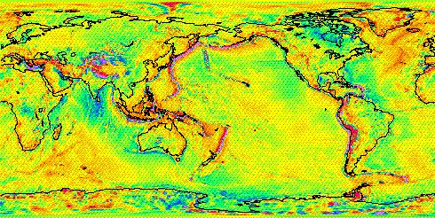
16 GPS field work in Indonesia in cooperation with local staff 16

17 Setting up a GPS field station in Sulawesi 17
")
18 Leica GPS receivers for field work (ISES funding) 18

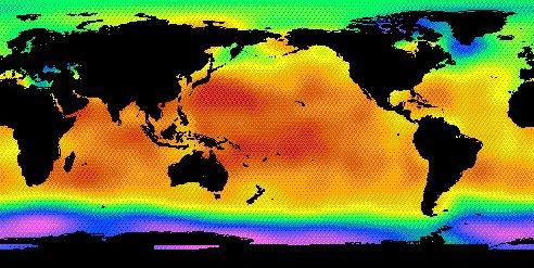
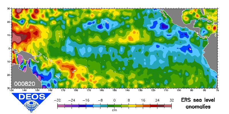
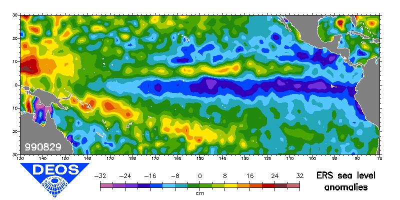
19 Equipment for permanent GPS station in Sulawesi (ISES funding) 19
20 Time-series of GPS position solutions of KOSG permanent station 20

21 Damage to railroad due to Izmit earthquake (Turkey, August 17, 1999) 21


22 Principle of satellite SAR Interferometry 22

23 Interferogram of two ERS-2 SAR images of Izmit earthquake 23

24 Campi Flegrei, Italy; interferometric phase image (Mar 97-Mar 99) 24


25 The Gravity and Ocean Circulation Explorer (GOCE) mission Geoid Gravity Anomalies 25
 Proof Mass Integrated View Exploded View")
26 GOCE Satellite Gravity Gradiometer (SGG) equipment (ONERA) Proof Mass Integrated View Exploded View Electrodes 26
 for sea surface")
27 Principle of satellite Radar Altimetry (RA) for sea surface height obs. 27
 satellite")
28 The Topex/Poseidon Radar Altimeter (RA) satellite mission 28


29 Evolution of El Nino/La Nina determined from RA observations 29

30 Changes in thickness of the Antarctic ice sheet from ERS-2 RA data 30
31 Measuring atmospheric water vapor with GPS 31
GG S. Internal Vision of GGOS. Markus Rothacher. GFZ Potsdam
 Internal Vision of GGOS Markus Rothacher GFZ Potsdam GGOS Retreat DGFI in Munich February 15-16, 2006 Contents Motivation Four Levels of Products of the IAG Services: First Level: Raw Data Collection Second
A Mission to Planet Mars Gravity Field Determination
 A Mission to Planet Mars Gravity Field Determination Department for Theoretical Geodesy Graz University of Technology and Space Research Institute Austrian Academy of Sciences Gravity field CHAMP GRACE
Satellite ALTimetry. SALT applications and use of data base for SE-Asia region. SEAMERGES kick-off meeting, Bangkok, Thailand.
 Satellite ALTimetry SALT applications and use of data base for SE-Asia region SEAMERGES kick-off meeting, Bangkok, Thailand Marc Naeije 4 March 2004 1 Faculty of Aerospace Engineering DEOS/AS SEAMERGES
GRACE impact in geodesy and geophysics. R. Biancale (GRGS-CNES Toulouse), M. Diament (IPG Paris)
, M. Diament (IPG Paris)") GRACE impact in geodesy and geophysics R. Biancale (GRGS-CNES Toulouse), M. Diament (IPG Paris) Improvement of gravity models Since 2002 the GRACE mission has changed some goals in geodesy. It has become
GRACE impact in geodesy and geophysics R. Biancale (GRGS-CNES Toulouse), M. Diament (IPG Paris) Improvement of gravity models Since 2002 the GRACE mission has changed some goals in geodesy. It has become
A Unique Reference Frame: Basis of the Global Geodetic Observing System (GGOS) for Geodynamics and Global Change
 for Geodynamics and Global Change") SRTM (InSAR) A Unique Reference Frame: Basis of the Global Geodetic Observing System (GGOS) for Geodynamics and Global Change Hermann Drewes President IAG Commission 1 Reference Frames Deutsches Geodätisches
SRTM (InSAR) A Unique Reference Frame: Basis of the Global Geodetic Observing System (GGOS) for Geodynamics and Global Change Hermann Drewes President IAG Commission 1 Reference Frames Deutsches Geodätisches
The Global Geodetic Observing System (GGOS) of the International Association of Geodesy, IAG
 of the International Association of Geodesy, IAG") The Global Geodetic Observing System (GGOS) of the International Association of Geodesy, IAG Hans-Peter Plag (1), Markus Rothacher (2), Richard Gross (3), Srinivas Bettadpur (4) (1) Nevada Bureau of Mines
The Global Geodetic Observing System (GGOS) of the International Association of Geodesy, IAG Hans-Peter Plag (1), Markus Rothacher (2), Richard Gross (3), Srinivas Bettadpur (4) (1) Nevada Bureau of Mines
The Earth Explorer Missions - Current Status
 EOQ N 66 July 2000 meteorology earthnet remote sensing solid earth future programmes Earth Observation Quarterly The Earth Explorer Missions - Current Status G. Mégie (1) and C.J. Readings (2) (1) Institut
Global & National Geodesy, GNSS Surveying & CORS Infrastructure
 Global & National Geodesy, GNSS Surveying & CORS Infrastructure Chris Rizos School of Surveying & Spatial Information Systems University of New South Wales, Sydney, Australia President-elect, International
P. Cipollini, H. Snaith - A short course on Altimetry. Altimetry 2 - Data processing (from satellite height to sea surface height)
") P. Cipollini, H. Snaith - A short course on Altimetry Altimetry 2 - Data processing (from satellite height to sea surface height) 1 2 Satellite height to sea surface height The altimeter measures the altitude
P. Cipollini, H. Snaith - A short course on Altimetry Altimetry 2 - Data processing (from satellite height to sea surface height) 1 2 Satellite height to sea surface height The altimeter measures the altitude
Report for 15th PCGIAP Meeting at 18th UNRCC-AP Working Group 1 Regional Geodesy
 Report for 15th PCGIAP Meeting at 18th UNRCC-AP Working Group 1 Regional Geodesy Chairman Shigeru Matsuzaka, Japan - shigeru@gsi.go.jp Vice Chairman Prof. Pengfei Cheng, China - chengpf@casm.ac.cn John
New satellite mission for improving the Terrestrial Reference Frame: means and impacts
 Fourth Swarm science meeting and geodetic missions workshop ESA, 20-24 March 2017, Banff, Alberta, Canada New satellite mission for improving the Terrestrial Reference Frame: means and impacts Richard
Determination of Marine Gravity Anomalies in the Truong Sa Archipelago s Sea Territory Using Satellite Altimeter Data
 This is a Peer Reviewed Paper Determination of Marine Gravity Anomalies in the Truong Sa Archipelago s Sea Territory Using Satellite Altimeter Data NGUYEN Van Sang, VU Van Tri, PHAM Van Tuyen, Vietnam
GG S Global Geodetic Observing System (GGOS): Status and Future. Markus Rothacher, Ruth Neilan, Hans-Peter Plag
: Status and Future. Markus Rothacher, Ruth Neilan, Hans-Peter Plag") 2020 Global Geodetic Observing System (GGOS): Status and Future Markus Rothacher, Ruth Neilan, Hans-Peter Plag GeoForschungsZentrum Potsdam (GFZ) Jet Propulsion Laboratory (JPL) University of Nevada, Reno
2020 Global Geodetic Observing System (GGOS): Status and Future Markus Rothacher, Ruth Neilan, Hans-Peter Plag GeoForschungsZentrum Potsdam (GFZ) Jet Propulsion Laboratory (JPL) University of Nevada, Reno
Active microwave systems (2) Satellite Altimetry * the movie * applications
 Satellite Altimetry * the movie * applications") Remote Sensing: John Wilkin wilkin@marine.rutgers.edu IMCS Building Room 211C 732-932-6555 ext 251 Active microwave systems (2) Satellite Altimetry * the movie * applications Altimeters (nadir pointing
Remote Sensing: John Wilkin wilkin@marine.rutgers.edu IMCS Building Room 211C 732-932-6555 ext 251 Active microwave systems (2) Satellite Altimetry * the movie * applications Altimeters (nadir pointing
Banda Aceh December 26th Earthquake monitored by GPS
 Banda Aceh December 26th Earthquake monitored by GPS C. Vigny (1), W.J.F. Simons (2), S. Abu (3), Chalermchon Satirapod (4), M. Hashizume (5), Sarayut Yousamran (6), C. Subarya (7), K. Omar (8), H.Z. Abidin
MASS TRANSPORT AND MASS DISTRIBUTION IN THE EARTH SYSTEM
 MASS TRANSPORT AND MASS DISTRIBUTION IN THE EARTH SYSTEM Jakob Flury (1) and Reiner Rummel (1) (1) German GOCE Project Bureau Institute for Astronomical and Physical Geodesy Technische Universität München,
Contributions of Geodesy to Oceanography
 Contributions of Geodesy to Oceanography B. Tapley and J. Ries Center for Space Research, The University of Texas at Austin Dynamic Planet 2005 Cairns, Australia August 22-26, 2005 August 22-26, 2005 Dynam
Interannual trends in the Southern Ocean sea surface temperature and sea level from remote sensing data
 RUSSIAN JOURNAL OF EARTH SCIENCES, VOL. 9, ES3003, doi:10.2205/2007es000283, 2007 Interannual trends in the Southern Ocean sea surface temperature and sea level from remote sensing data S. A. Lebedev 1,2
Graz in Space Graz SLR System. Daniel Kucharski. IWF / SatGeo
 Graz in Space 2008 Graz SLR System Daniel Kucharski IWF / SatGeo Satellite Laser Ranging Range measurements to the satellites - time of flight of the ultrashort laser pulses - mm precision station-satellite
1 The satellite altimeter measurement
 1 The satellite altimeter measurement In the ideal case, a satellite altimeter measurement is equal to the instantaneous distance between the satellite s geocenter and the ocean surface. However, an altimeter
Interferometric Synthetic Aperture Radar (InSAR) and GGOS. Andrea Donnellan NASA/JPL February 21, 2007
 and GGOS. Andrea Donnellan NASA/JPL February 21, 2007") Interferometric Synthetic Aperture Radar (InSAR) and GGOS Andrea Donnellan NASA/JPL February 21, 2007 Sources for Science Objectives Fourth component of EarthScope Involvement: NSF, NASA, USGS, Universities
Interferometric Synthetic Aperture Radar (InSAR) and GGOS Andrea Donnellan NASA/JPL February 21, 2007 Sources for Science Objectives Fourth component of EarthScope Involvement: NSF, NASA, USGS, Universities
B. Loomis, D. Wiese, R. S. Nerem (1) P. L. Bender (2) P. N. A. M. Visser (3)
 P. L. Bender (2) P. N. A. M. Visser (3)") Possible mission architectures for a GRACE follow-on mission including a study on upgraded instrumentation suites, and multiple satellite pairs in moderately-inclined orbits B. Loomis, D. Wiese, R. S.
Possible mission architectures for a GRACE follow-on mission including a study on upgraded instrumentation suites, and multiple satellite pairs in moderately-inclined orbits B. Loomis, D. Wiese, R. S.
The GOCE User Toolbox
 The GOCE User Toolbox Jérôme Benveniste - ESA Earth Observation Science and Applications Department Per Knudsen - Danish National Space Center and the GUT TEAM 37th COSPAR Scientific Assembly 2008, Montreal
From Global to National Geodetic Reference Frames: how are they connected and why are they needed?
 From Global to National Geodetic Reference Frames: how are they connected and why are they needed? Zuheir ALTAMIMI Institut National de l Information Géographique et Forestière, France Vice-President,
TECH NOTE. New Mean Sea Surface for the CryoSat-2 L2 SAR Chain. Andy Ridout, CPOM, University College London
 TECH NOTE Subject : From : To : New Mean Sea Surface for the CryoSat-2 L2 SAR Chain Andy Ridout, CPOM, University College London Tommaso Parrinello, CryoSat Mission Manager, ESRIN Date : 30 th June 2014
GS 873 Advanced Satellite Geodesy. Laboratory No. 2. April 8, Problem: Quantification of Satellite Orbit Errors Due to Gravity
 GS 873 Advanced Satellite Geodesy Laboratory No. 2 April 8, 2004 Instructor: C.K. Shum, ckshum@osu.edu Instructor Assistant: Shengjie Ge, ge.18@osu.edu Problem: Quantication of Satellite Orbit Errors Due
GEOSC/METEO 597K Kevin Bowley Kaitlin Walsh
 GEOSC/METEO 597K Kevin Bowley Kaitlin Walsh Timeline of Satellites ERS-1 (1991-2000) NSCAT (1996) Envisat (2002) RADARSAT (2007) Seasat (1978) TOPEX/Poseidon (1992-2005) QuikSCAT (1999) Jason-2 (2008)
Radar Remote Sensing: Monitoring Ground Deformations and Geohazards from Space
 Radar Remote Sensing: Monitoring Ground Deformations and Geohazards from Space Xiaoli Ding Department of Land Surveying and Geo-Informatics The Hong Kong Polytechnic University A Question 100 km 100 km
ESA s Earth Observation Programmes
 ESA s Earth Observation Programmes 2015 DRAGON Symposium Interlaken, 23 June 2015 Maurice Borgeaud Head of the Department Science, Applications, and Future Technologies ESA Earth Observation Programmes
Gravimetry: Theory and Applications
 Satellite Altimetry and Gravimetry Gravimetry: Theory and Applications C.K. Shum 1,2, Alexander Bruan 2,1 1,2 Laboratory for Space Geodesy & Remote Sensing 2,1 Byrd Polar Research Center The Ohio State
Contributions of geodesy to monitoring natural hazards and global change
 Contributions of geodesy to monitoring natural hazards and global change Prof. Dr. Harald Schuh Director Dept. 1: Geodesy and Remote Sensing Helmholtz Centre Potsdam, GFZ German Research Centre for Geosciences
Exploiting radar power to study oceans and climate: the rise and prospects of satellite altimetry
 Exploiting radar power to study oceans and climate: the rise and prospects of satellite altimetry Paolo Cipollini National Oceanography Centre, Southampton, UK with contributions by Peter Challenor, Ian
High-Harmonic Geoid Signatures due to Glacial Isostatic Adjustment, Subduction and Seismic Deformation
 High-Harmonic Geoid Signatures due to Glacial Isostatic Adjustment, Subduction and Seismic Deformation L.L.A. Vermeersen (1), H. Schotman (1), M.-W. Jansen (1), R. Riva (1) and R. Sabadini (2) (1) DEOS,
Hydrological balance in the large Russian river basins from GRACE satellites
 Hydrological balance in the large Russian river basins from GRACE satellites Leonid Zotov 1,2, Natalya Frolova 3, E. Kyzyngasheva 1, C.K. Shum 4,5 1 NRU Higher School of Economics, Russia 2 SAI Moscow
GGOS INFORMATION MODELS: ANALYSIS OF INTERRELATIONS BETWEEN OBSERVATION TECHNIQUES AND THE EARTH GRAVITY FIELD
 GGOS INFORMATION MODELS: ANALYSIS OF INTERRELATIONS BETWEEN OBSERVATION TECHNIQUES AND THE EARTH GRAVITY FIELD Wojciech Pachelski 1) Małgorzata Paśnicka-Pawłowska 2) Karolina Szafranek 3) Agnieszka Zwirowicz
Assimilation of satellite altimetry referenced to the new GRACE geoid estimate
 GEOPHYSICAL RESEARCH LETTERS, VOL. 32, L06601, doi:10.1029/2004gl021329, 2005 Assimilation of satellite altimetry referenced to the new GRACE geoid estimate F. Birol, 1 J. M. Brankart, 1 J. M. Lemoine,
Dependences in the pillar Earth s gravity field of
 Reports on Geodesy, vol. 92, no. 1, 2012 Dependences in the pillar Earth s gravity field of GGOS - description using UML notation Małgorzata Paśnicka 1, Karolina Szafranek 2, Agnieszka Zwirowicz Rutkowska
SLR Graz: khz Satellite Laser Ranging & Co
 Graz in Space 2014 KFU Graz 4. 5. September 2014 SLR Graz: khz Satellite Laser Ranging & Co Georg Kirchner, Franz Koidl, Oliver Baur Space Research Institute Austrian Academy of Sciences Outline What is
Geophysik mittels Satellitenbeobachtungen - Von der Struktur zur dynamischen Betrachtung der Erde
 Geophysik mittels Satellitenbeobachtungen - Von der Struktur zur dynamischen Betrachtung der Erde Jörg Ebbing Institut für Geowissenschaften Christian-Albrechts-Universität zu Kiel 102. Sitzung des FKPE
Ice sheet mass balance from satellite altimetry. Kate Briggs (Mal McMillan)
") Ice sheet mass balance from satellite altimetry Kate Briggs (Mal McMillan) Outline Background Recap 25 year altimetry record Recap Measuring surface elevation with altimetry Measuring surface elevation
Ice sheet mass balance from satellite altimetry Kate Briggs (Mal McMillan) Outline Background Recap 25 year altimetry record Recap Measuring surface elevation with altimetry Measuring surface elevation
Actual Continuous Kinematic Model (ACKIM) of the Earth s Crust based on ITRF2014
 of the Earth s Crust based on ITRF2014") Actual Continuous Kinematic Model (ACKIM) of the Earth s Crust based on ITRF2014 Hermann Drewes Technische Universität München Joint Scientific Assembly of the International Association of Geodesy and
Actual Continuous Kinematic Model (ACKIM) of the Earth s Crust based on ITRF2014 Hermann Drewes Technische Universität München Joint Scientific Assembly of the International Association of Geodesy and
GOCE. Gravity and steady-state Ocean Circulation Explorer
 GOCE Gravity and steady-state Ocean Circulation Explorer Reiner Rummel Astronomical and Physical Geodesy Technische Universität München rummel@bv.tum.de ESA Earth Observation Summerschool ESRIN/Frascati
Co-location of VLBI with other techniques in space: a simulation study
 Co-location of VLBI with other techniques in space: a simulation study B. Männel, M. Rothacher ETH Zürich, Geodesy and Geodynamics Lab 7 th IGS General Meeting, Madrid 212 1 Reference frame and local ties
FRENCH TRANSPORTABLE LASER RANGING STATION: POSITIONING CAMPAIGNS FOR SATELLITE ALTIMETER CALIBRATION MISSIONS IN OCCIDENTAL MEDITERRANEAN SEA
 Larhyss Journal, ISSN 1112-3680, n 12, Janvier 2013, pp. 57-69 2013 Tous droits réservés FRENCH TRANSPORTABLE LASER RANGING STATION: POSITIONING CAMPAIGNS FOR SATELLITE ALTIMETER CALIBRATION MISSIONS IN
GEO-VIII November Geohazard Supersites and Natural Laboratories Progress Report. Document 9
 GEO-VIII 16-17 November 2011 Geohazard Supersites and Natural Laboratories Progress Report Document 9 This document is submitted to GEO-VIII for information. Geohazard Supersites and Natural Laboratories
GOCE Research in Germany: From Sensor Analysis to Earth System Science
 GOCE Research in Germany: From Sensor Analysis to Earth System Science Reiner Rummel, Jakob Flury and Thomas Gruber Institut für Astronomische und Physikalische Geodäsie Technische Universität München
Fundamental Station Wettzell - geodetic observatory -
 Fundamental Station Wettzell - geodetic observatory - Wolfgang Schlüter Bundesamt für Kartographie und Geodäsie, Fundamental Station Wettzell Germany Radiometer Workshop, Wettzell, 10.10.06 Evolvement
High resolution geoid from altimetry & bathymetry: requirements for a future mission
 High resolution geoid from altimetry & bathymetry: requirements for a future mission The GRAL team: J-Y Royer 1,2, M-F Lalancette 3, G Louis 1,2, M Maia 1,2, D Rouxel 3 & L Géli 4 Project funded by 1 2
Presented at the FIG Congress 2018, May 6-11, 2018 in Istanbul, Turkey
 Presented at the FIG Congress 2018, May 6-11, 2018 in Istanbul, Turkey Paper ID: 9253 (Peer Review) By: Amalina Izzati Abdul Hamid, Ami Hassan Md Din & Kamaludin Mohd Omar Geomatic Innovation Research
Geodetic Observing Systems: tools in observing the Glacial Isostatic Adjustment. Markku Poutanen Finnish Geodetic Institute
 Geodetic Observing Systems: tools in observing the Glacial Isostatic Adjustment Markku Poutanen Finnish Geodetic Institute Glacial Isostatic Adjustment Land uplift is just one consequence of the physical
ERS ORBIT DETERMINATION AND GRAVITY FIELD MODEL TAILORING: RECENT DEVELOPMENTS
 ERS ORBIT DETERMINATION AND GRAVITY FIELD MODEL TAILORING: RECENT DEVELOPMENTS Remko Scharroo 1, Pieter Visser 1 and Neil Peacock 2 1 Delft Institute for Earth-Oriented Space Research, Delft University
Torsten Mayer-Gürr Institute of Geodesy, NAWI Graz Technische Universität Graz
 GGOS and Reference Systems Introduction 2015-10-12 Torsten Mayer-Gürr Institute of Geodesy, NAWI Graz Technische Universität Graz Torsten Mayer-Gürr 1 Course and exam Lecture Monday 14:00 16:00, A111 (ST01044)
Spaceborne radar applications in Geology
 216 051 ESATM-17 December 2005 Spaceborne radar applications in Geology An introduction to imaging radar, and application examples of ERS SAR in Geology and Geomorphology European Spate Agency Agente spatiale
Report on Banda Aceh mega-thrust earthquake, December 26, 2004
 Report on Banda Aceh mega-thrust earthquake, December 26, 2004 Prepared January 7 th 2005 by C. Vigny, on behalf of the SEAMERGES (*) participants On the morning of December 26 th, 2004 in SE Asia, 30
The Earth s time-variable gravity field observed by GOCE
 The Earth s time-variable gravity field observed by GOCE GOCE+ Time-Variations, part of STSE (Theme 4, Innovative Feasibility Studies) J. Bouman, M. Fuchs, C. Haberkorn, V. Lieb, M. Schmidt T. Broerse,
(1) , 6WHYH.HQ\RQ (2) *HRG\QDPLFV 'HSW 1DWLRQDO 6XUYH\ DQG &DGDVWUH 5HQWHPHVWHUYHM '. &RSHQKDJHQ 19 'HQPDUN UI#NPV GN
 , 6WHYH.HQ\RQ (2) *HRG\QDPLFV 'HSW 1DWLRQDO 6XUYH\ DQG &DGDVWUH 5HQWHPHVWHUYHM '. &RSHQKDJHQ 19 'HQPDUN UI#NPV GN") *5$9,7
*5$9,7
INSAR ATMOSPHERIC DELAY MIGITIGATION BY GPS; CASE STUDY IZMIT EARTQUAKE INTERFEROGRAMS
 INSAR ATMOSPHERIC DELAY MIGITIGATION BY GPS; CASE STUDY IZMIT EARTQUAKE INTERFEROGRAMS M.U. Altın a, *, E. Tari a, L. Ge b a ITU, Civil Engineering Faculty, 80626 Maslak Istanbul, Turkey (altinm, tari)@itu.edu.tr
DERIVATION OF SEA LEVEL ANOMALY USING SATELLITE ALTIMETER. Ami Hassan Md Din, Kamaludin Mohd Omar
 DERIVATION OF SEA LEVEL ANOMALY USING SATELLITE ALTIMETER Ami Hassan Md Din, Kamaludin Mohd Omar Faculty of Geoinformation Science and Engineering Universiti Teknologi Malaysia Skudai, Johor E-mail: amihassan@utm.my
NEXT GENERATION ALTIMETER SERVICE CHALLENGES AND ACHIEVEMENTS
 NEXT GENERATION ALTIMETER SERVICE CHALLENGES AND ACHIEVEMENTS M. Naeije (1), R. Scharroo (2), and E. Doornbos (1) (1) DEOS, Delft University of Technology, Kluyverweg 1, 2629 HS Delft, Netherlands (2)
Overview and Status of ESA Earth Observation Programmes
 Overview and Status of ESA Earth Observation Programmes Maurice Borgeaud, ESA Head of the Science, Applications and Future Technologies Department Directorate of Earth Observation Programmes ADM-Aeolus
Presented at the FIG Congress 2018, May 6-11, 2018 in Istanbul, Turkey
 Presented at the FIG Congress 2018, May 6-11, 2018 in Istanbul, Turkey A Geoid model of northern Chile from airborne and surface gravity Geographic Description of Chile. Total Surface: 2,006,096 Km 2.
A Factor of 2-4 Improvement in Marine Gravity and Predicted Bathymetry from CryoSat, Jason-1, and Envisat Radar Altimetry: Arctic and Coastal Regions
 DISTRIBUTION STATEMENT A. Approved for public release; distribution is unlimited. A Factor of 2-4 Improvement in Marine Gravity and Predicted Bathymetry from CryoSat, Jason-1, and Envisat Radar Altimetry:
Towards a Rigorous Combination of Space Geodetic Techniques
 Towards a Rigorous Combination of Space Geodetic Techniques Markus Rothacher Forschungseinrichtung Satellitengeodäsie, TU Munich, Germany Abstract: The with all its different components and products, ranging
AIMING AT A I-CM ORBIT FOR LOW EARTH ORBITERS: REDUCED-DYNAMIC AND KINEMATIC PRECISE ORBIT DETERMINATION
 AIMING AT A I-CM ORBIT FOR LOW EARTH ORBITERS: REDUCED-DYNAMIC AND KINEMATIC PRECISE ORBIT DETERMINATION P.N.A.M. VISSER (pieter. visser@lr. tudel ft. nl) and J. VAN DEN IJSSEL (j ose. vandenij ssel@lr.
Basics of the modelling of the ground deformations produced by an earthquake. EO Summer School 2014 Frascati August 13 Pierre Briole
 Basics of the modelling of the ground deformations produced by an earthquake EO Summer School 2014 Frascati August 13 Pierre Briole Content Earthquakes and faults Examples of SAR interferograms of earthquakes
What are the social, technical, environmental and economic benefits and opportunities of accessing and sharing geodetic data?
 What are the social, technical, environmental and economic benefits and opportunities of accessing and sharing geodetic data? Graeme Blick Group Manager Positioning and Resilience Land Information New
Satellite Oceanography and Applications 2: Altimetry, scatterometry, SAR, GRACE. RMU Summer Program (AUGUST 24-28, 2015)
") Satellite Oceanography and Applications 2: Altimetry, scatterometry, SAR, GRACE RMU Summer Program (AUGUST 24-28, 2015) Altimetry 2 Basic principles of satellite altimetry Altimetry: the measurements of
Satellite Oceanography and Applications 2: Altimetry, scatterometry, SAR, GRACE RMU Summer Program (AUGUST 24-28, 2015) Altimetry 2 Basic principles of satellite altimetry Altimetry: the measurements of
Towards an improved ILRS TRF contribution
 Towards an improved ILRS TRF contribution Erricos C. Pavlis ILRS Analysis Coordinator JCET/ & NASA Goddard IERS Workshop on Conventions 2007 20-21 Sept. 2007, Sèvres, France Overview The ILRS Network Geometry
Report on Banda Aceh mega-thrust earthquake, December 26, 2004
 Report on Banda Aceh mega-thrust earthquake, December 26, 2004 Prepared January 7 th 2005 by C. Vigny, on behalf of the SEAMERGES (*) participants On the morning of December 26 th in SE Asia, 30 km below
to: Interseismic strain accumulation and the earthquake potential on the southern San
 Supplementary material to: Interseismic strain accumulation and the earthquake potential on the southern San Andreas fault system by Yuri Fialko Methods The San Bernardino-Coachella Valley segment of the
GGOS Bureau for Standards and Conventions
 GGOS D. Angermann (1), T. Gruber (2), J. Bouman (1), M. Gerstl (1), R. Heinkelmann (1), U. Hugentobler (2), L. Sánchez (1), P. Steigenberger (2) (1) Deutsches Geodätisches Forschungsinstitut (DGFI), München
ESA s supporting Activities Related to Mass Transport in the Earth System
 ESA s supporting Activities Related to Mass Transport in the Earth System Roger Haagmans Mission Science Division European Space Agency Swarm mission: 3D-Mantle Conductivity (A. Jackson ETH Zürich, DNSC,
Time-variable gravity from SLR and DORIS tracking
 Time-variable gravity from SLR and DORIS tracking Frank G. Lemoine 1, Steven M. Klosko 2, Christopher M. Cox 3, Thomas J. Johnson 4 1. Planetary Geodynamics Laboratory, NASA Goddard Space Flight Center,
Lab 9: Satellite Geodesy (35 points)
") Lab 9: Satellite Geodesy (35 points) Here you will work with GPS Time Series data to explore plate motion and deformation in California. This lab modifies an exercise found here: http://www.unavco.org:8080/cws/pbonucleus/draftresources/sanandreas/
Lab 9: Satellite Geodesy (35 points) Here you will work with GPS Time Series data to explore plate motion and deformation in California. This lab modifies an exercise found here: http://www.unavco.org:8080/cws/pbonucleus/draftresources/sanandreas/
Inter comparison of wave height observations from buoy and altimeter with numerical prediction
 Indian Journal of Geo-Marine Sciences Vol. 43(7), July 2014, pp. 1347-1351 Inter comparison of wave height observations from buoy and altimeter with numerical prediction S. A. Sannasiraj 1*, M. Kalyani
Earth gravity field recovery using GPS, GLONASS, and SLR satellites
 Earth gravity field recovery using GPS, GLONASS, and SLR satellites Krzysztof Sośnica (1), Adrian Jäggi (1), Daniela Thaller (2), Ulrich Meyer (1), Gerhard Beutler (1), Rolf Dach (1) (1) Astronomical Institute,
DLR s TerraSAR-X contributes to international fleet of radar satellites to map the Arctic and Antarctica
 DLR s TerraSAR-X contributes to international fleet of radar satellites to map the Arctic and Antarctica The polar regions play an important role in the Earth system. The snow and ice covered ocean and
The Global Geodetic Observing System (GGOS) of the International Association of Geodesy (IAG)
 of the International Association of Geodesy (IAG)") The Global Geodetic Observing System (GGOS) of the International Association of Geodesy (IAG) Hermann Drewes Representative of the International Union of Geodesy and Geophysics (IUGG) to the Cartographic
The Global Geodetic Observing System (GGOS) of the International Association of Geodesy (IAG) Hermann Drewes Representative of the International Union of Geodesy and Geophysics (IUGG) to the Cartographic
Using Remote-sensed Sea Ice Thickness, Extent and Speed Observations to Optimise a Sea Ice Model
 Using Remote-sensed Sea Ice Thickness, Extent and Speed Observations to Optimise a Sea Ice Model Paul Miller, Seymour Laxon, Daniel Feltham, Douglas Cresswell Centre for Polar Observation and Modelling
RECENT DYNAMIC OCEAN TOPOGRAPHY MODELS AND THEIR COMPARISON
 INFRASTRUKTURA I EKOLOGIA TERENÓW WIEJSKICH INFRASTRUCTURE AND ECOLOGY OF RURAL AREAS Recent dynamic ocean Nr 11/2010, POLSKA AKADEMIA NAUK, Oddział w Krakowie, s. 151 158 Komisja Technicznej Infrastruktury
Deformation measurement using SAR interferometry: quantitative aspects
 Deformation measurement using SAR interferometry: quantitative aspects Michele Crosetto (1), Erlinda Biescas (1), Ismael Fernández (1), Ivan Torrobella (1), Bruno Crippa (2) (1) (2) Institute of Geomatics,
Tectonic deformations in Greece and the operation of HEPOS network
 Tectonic deformations in Greece and the operation of HEPOS network M. Gianniou KTIMATOLOGIO S.A. (Hellenic Cadastre) Abstract Today, networks of permanent reference stations are broadly used for the realization
Update on the International Terrestrial Reference Frame (ITRF) : ITRF2014. Zuheir Altamimi
 : ITRF2014. Zuheir Altamimi") Update on the International Terrestrial Reference Frame (ITRF) : ITRF2014 Zuheir Altamimi Head of the IERS ITRF Product Center IAG Vice President IGN, France E-mail: zuheir.altamimi@ign.fr Key Points Introduction:
Update on the International Terrestrial Reference Frame (ITRF) : ITRF2014 Zuheir Altamimi Head of the IERS ITRF Product Center IAG Vice President IGN, France E-mail: zuheir.altamimi@ign.fr Key Points Introduction:
Antarctic Ice Sheet cci. Anna Hogg
 Antarctic Ice Sheet cci Anna Hogg Overview 1.Project Summary and Status 2.AIS cci Products Surface Elevation Change Gravimetry Mass Balance Ice Velocity Grounding Line Location 3.Climate Assessment 4.AIS
Geodesy Part of the ACES Mission: GALILEO on Board the International Space Station
 Geodesy Part of the ACES Mission: GALILEO on Board the International Space Station 1 Svehla D, 2 Rothacher M, 3 Salomon C, 2 Wickert J, 2 Helm A, 2 Beyerle, G, 4 Ziebart M, 5 Dow J 1 Institute of Astronomical
HY-2A Satellite User s Guide
 National Satellite Ocean Application Service 2013-5-16 Document Change Record Revision Date Changed Pages/Paragraphs Edit Description i Contents 1 Introduction to HY-2 Satellite... 1 2 HY-2 satellite data
Earth Observatory of Singapore. Nina Lin 22 Jan 2018
 Earth Observatory of Singapore Nina Lin 22 Jan 2018 EOS Our Mission Our Mission Director Prof. Kerry Sieh The Earth Observatory of Singapore conducts fundamental research on earthquakes, volcanic eruptions,
COMPOSITION and PHYSICAL PROPERTIES GENERAL SUBJECTS. GEODESY and GRAVITY
 COMPOSITION and PHYSICAL PROPERTIES Composition and structure of the continental crust Composition and structure of the core Composition and structure of the mantle Composition and structure of the oceanic
Theory of Plate Tectonics
 Theory of Plate Tectonics The Theory of Plate Tectonics Plate tectonics is the theory that the Earth's lithosphere is divided into tectonic plates that move around on top of the asthenosphere. The plates
Model name GO_CONS_GCF_2_DIR_R5 Producer Method Data period Max. degree Input data Processing strategy
 Model name GO_CONS_GCF_2_DIR_R5 Producer - GFZ German Research Centre for Geosciences Potsdam, Section 1.2 Global Geomonitoring and Gravity Field - Groupe de Recherche de Géodésie Spatiale (GRGS)/CNES,
More than 60% of the Earth s land and shallow
 SPECIAL G r a v SECTION: i t y a n d G rpaov ti et ny tand i a l fpotential i e l d s fields Toward 1-mGal accuracy in global marine gravity from CryoSat-2, Envisat, and Jason-1 DAVID SANDWELL and EMMANUEL
GGOS, ECGN and NGOS: Global and regional geodetic observing systems. Markku Poutanen Finish Geodetic Institute
 GGOS, ECGN and NGOS: Global and regional geodetic observing systems Markku Poutanen Finish Geodetic Institute Contents GGOS, ECGN, NGOS Why? How? Future? (geodesy) GGOS Structure GGOS Structure European
The GOCE Geoid in Support to Sea Level Analysis
 The GOCE Geoid in Support to Sea Level Analysis The geoid is a very useful quantity for oceanographers Thomas Gruber Astronomical & Physical Geodesy (IAPG) Technische Universität München 1. Characteristics
Studies of Austfonna ice cap (Svalbard) using radar altimetry with other satellite techniques
 using radar altimetry with other satellite techniques") 15 Years of progress in Radar Altimetry Symposium Ocean surface topography science team (OSTST) International Doris Service (IDS) Workshop, Argo Workshop 13-18 March 2006, Venice, Italy Alexei V. Kouraev,
15 Years of progress in Radar Altimetry Symposium Ocean surface topography science team (OSTST) International Doris Service (IDS) Workshop, Argo Workshop 13-18 March 2006, Venice, Italy Alexei V. Kouraev,
GLOBAL WAVEFORM SHAPE ANALYSIS FOR THE DETECTION AND MONITORING OF EPHEMERAL SURFACE WATER
 GLOBAL WAVEFORM SHAPE ANALYSIS FOR THE DETECTION AND MONITORING OF EPHEMERAL SURFACE WATER Dowson, M. (1), Berry, P.A.M. (1), Freeman, J.A. (1) (1) De Montfort University EAPRS Lab, De Montfort University,
ON THE ACCURACY OF CURRENT MEAN SEA SURFACE MODELS FOR THE USE WITH GOCE DATA
 ON THE ACCURACY OF CURRENT MEAN SEA SURFACE MODELS FOR THE USE WITH GOCE DATA Ole B. Andersen 1, M-.H., Rio 2 (1) DTU Space, Juliane Maries Vej 30, Copenhagen, Denmark (2) CLS, Ramon St Agne, France ABSTRACT
esurge A Storm Surge Demonstration Project
 esurge A Storm Surge Demonstration Project Helen Snaith British Oceanographic Data Centre, National Oceanography Centre, UK The Impact of Storm Surges Great flood in the Netherlands History: Zeeland, 31
Combining InSAR, Levelling and GNSS for the Estimation of 3D Surface Displacements
 Combining InSAR, Levelling and GNSS for the Estimation of 3D Surface Displacements Thomas Fuhrmann (1), Miguel Caro Cuenca (2), Freek van Leijen (3), Malte Westerhaus (1), Ramon Hanssen (3), Bernhard Heck
ESA Status Report. ET-SAT-11, WMO, Geneva, CH, 4 April Prepared by Earth Observation Programmes Directorate
 ESA Status Report ET-SAT-11, WMO, Geneva, CH, 4 April 2017 Prepared by Earth Observation Programmes Directorate Presented by Ivan Petiteville, ESA, Earth Observation Programmes Issue/Revision: 0.0 Reference:
Originally published as:
 Originally published as: Bruinsma, S., Förste, C., Abrikosov, O., Marty, J. C., Rio, M. H., Mulet, S., Bonvalot, S. (2013): The new ESA satellite only gravity field model via the direct approach. Geophysical