Active microwave systems (2) Satellite Altimetry * the movie * applications
|
|
|
- Rosanna Dalton
- 5 years ago
- Views:
Transcription
")
1 Remote Sensing: John Wilkin IMCS Building Room 211C ext 251 Active microwave systems (2) Satellite Altimetry * the movie * applications


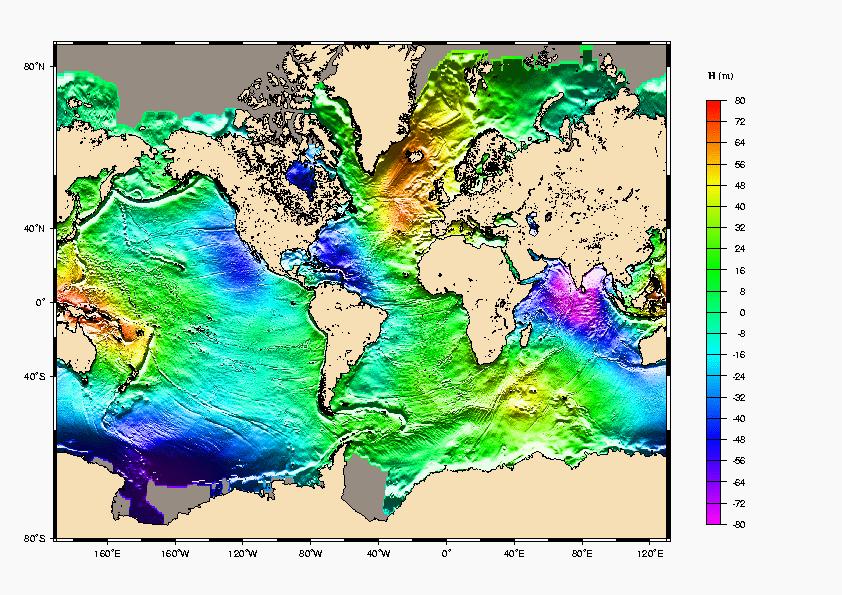
2 Altimeters (nadir pointing radar) sea surface height (long wavelengths ~50 km) mesoscale currents, eddies, fronts thermal expansion significant wave height wind speed gravity and bathymetry ice sheets
3 Satellite Altimeters nadir-pointing satellite-based radars measures the range from satellite to surface of the Earth radar pulse is reflected from the Earth s surface measure the round-trip travel time range from satellite to surface is R = ½ ct where c = speed of light Precision Orbit Determination (POD) systems measure the altitude of the satellite above a reference ellipsoid several corrections must be made for atmosphere and sea state effects on range calculation
4 Sea surface HEIGHT (SSH) Sea Surface Height is satellite altitude minus range It comprises two contributions: geoid and dynamic topography Geoid: The sea surface height that would exist without any motion. This surface is due to gravity variations around the planet due to mass and density differences on the seafloor Major bathymetric features deform sea level by tens of meters and are visible as a hill on the geoid Dynamic topography The ocean circulation comprises a permanent mean component linked to Earth's rotation, mean winds, and density patterns and a highly variable component (wind variability, tides, seasonal heating, eddies)
5 How altimetry works: Sea Surface Height SSH = altitude - range = Geoid + dyn. topography To get dynamic topography the easiest way would be to subtract the geoid from SSH D = SSH - G The geoid is not yet known accurately enough for all oceanographic applications, but this is changing due to the GRACE mission
6

 and gravity changes due to the")
7 GRACE: Gravity Recovery and Climate Experiment Dedicated mission for observing the mean gravity field (geoid) and gravity changes due to the hydrologic cycle.

8 GRACE: Gravity Recovery and Climate Experiment

9 GRACE: Gravity Recovery and Climate Experiment

10 Gravity anomalies from 363 days of GRACE data (GGM02S)
 (b) Ocean currents from direct measurement by floats deployed from ships.")
11 (a) Circulation at 1000 m depth obtained from the GRACE geoid combined with satellite altimetry and ship measurements. Note that the flow direction in the Gulf Stream extension matches that measured by shipdeployed floats in (b) (b) Ocean currents from direct measurement by floats deployed from ships. This can be compared to the panels above and below. (c) Same as (a) except that the best gravity model prior to GRACE was used. In many areas the implied currents are flowing in the wrong direction.
12 Jason satellite AVISO Web site

13 Jason launch movies
14 Topex/Poseidon and Jason satellites (same orbit) altitude 1336 km relatively high: less drag and more stable orbit inclination of 66 to Earth's polar axis it can "see" only up to 66 North and South the satellite repeats the same ground track every days the ground-tracks are 315 km apart at the equator track repeat precision is about 1km ground scanning velocity is 5.8 km/s, orbit velocity 7.2 km/s


15 Where is Jason now? Where is Topex now?
16 Tidal aliasing considerations Orbital parameters (inclination, altitude and precession rate which set orbital period) should be chosen so that the alias period of energetic tidal harmonic constituents is at least resolved by the duration of the altimeter mission, and preferably to frequencies of less than 2 cycles per year. Aliased tide variations (which appear to be low frequency signals) are phase shifted on adjacent ground-tracks by several days, and can appear to propagate westward or eastward
17
18 Altimetry: How it works For altimeter observations to be useful for oceanography, range accuracy of order 2 cm is required. Where is Jason now?
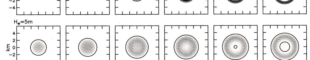
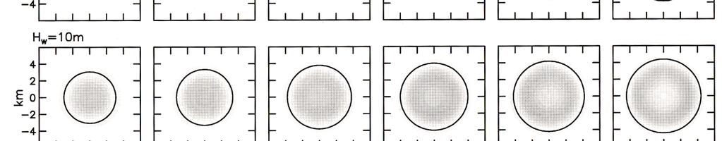
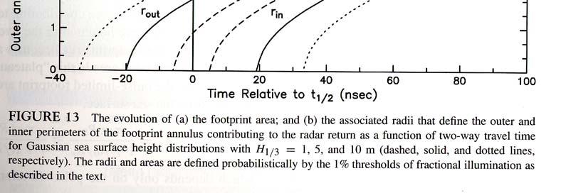
19 Pulse-limited altimetry Foot-print size on the sea surface: large enough to filter out surface gravity waves small enough to resolve Rossby radius ~ 100 km wave field and roughness (radar cross-section) are homogeneous 1 10 km satisfies these criteria Antenna beam width depends on: range and foot-print size => 0.21 o for T/P Antenna diameter depends on: EM wavelength and beam width => d = 7.7 m Too big to fly, and beam-limited design is sensitive to pointing errors
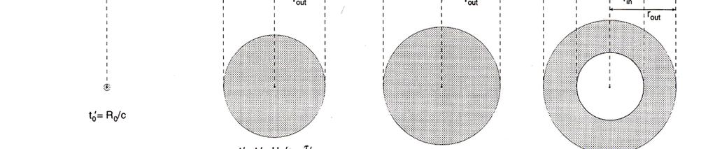
20 Pulse-limited altimetry
21
22


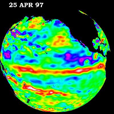
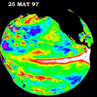
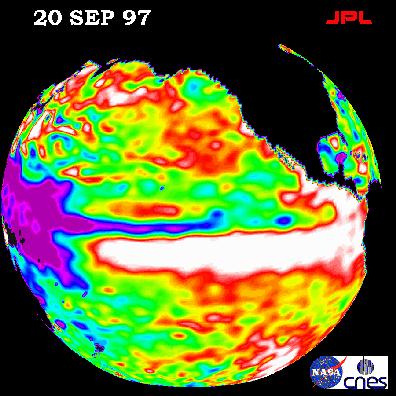
23 The onboard Adaptive Tracking Unit analyzes the returned pulses to estimate two-way travel time, wave height and radar cross-section.
24 Dry tropospheric correction Corrections to the range calculation: by far the most significant adjustment to 2-way travel time correction involves vertical integral of the air density and is thus proportional to mean sea level pressure (MSLP) analyzed MSLP fields from ECMWF are used in Jason processing Wet troposphere correction vertical integral of water vapor determined from an onboard radiometer Ionospheric correction variation in the number of free electrons present in the sub-satellite ionosphere varies from day to night (few free electrons at night), season (fewer during summer), and solar cycle effect is inversely proportional to transmitter frequency Poseidon is a dual-frequency altimeter so differential response provides information on range correction Atmospheric modeling and GPS (also dual frequency) can be used to map ionosphere electron density
25
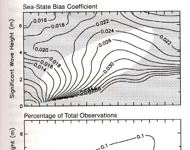
26 Corrections to the range calculation: Electromagnetic bias ocean troughs have a larger radius of curvature than wave crests greater reflection from wave troughs than wave crests induces an EM sea level bias toward wave troughs scatter at crests due to small scale roughness increases the effect difference between height of mean sea level and mean scattering surface backscatter from small wave facet is proportional to curvature of long wave part of spectrum Skewness bias non-gaussian distribution of the sea surface height shifts the median from the mean sea level toward wave troughs adding to the EM bias towards wave troughs Combined sea-state bias depends on significant wave height, but also stage of development of the sea: fetch limited vs duration limited presence of swell (which has less bias) these cannot be determined from the altimeter pulse waveform Where is Jason now?
27
28 The challenges to achieving 2 cm accuracy are: computing the satellite position accurately range corrections for the atmosphere density of atmosphere, water vapor accounting for the aliasing of tides knowing the shape of a reference gravitational potential surface, or geoid, that defines a surface along which gravity is constant (and therefore dynamically level )
29

30 Applications Large-scale ocean circulation
31
32
33 Applications: ENSO observation

34 Applications Meso-scale vectors currents from groundtrack cross-over points CHAPTER 3, FIGURE 9. Velocity variance ellipses in the East Australian Currnet from Geosat observations at crossover points and long-term surface drifter data, plotted over bathymetry (From Wilkin, J. and Morrow, R.A With permission)
35 Applications Sea-level rise
36 Applications Tidal dissipation
37 Applications Tidal energy flux

38 Applications Ice-sheet dynamics

39 Applications Operational oceanography e.g. Mercator Where is Jason now?
40
P. Cipollini, H. Snaith - A short course on Altimetry. Altimetry 2 - Data processing (from satellite height to sea surface height)
") P. Cipollini, H. Snaith - A short course on Altimetry Altimetry 2 - Data processing (from satellite height to sea surface height) 1 2 Satellite height to sea surface height The altimeter measures the altitude
P. Cipollini, H. Snaith - A short course on Altimetry Altimetry 2 - Data processing (from satellite height to sea surface height) 1 2 Satellite height to sea surface height The altimeter measures the altitude
1 The satellite altimeter measurement
 1 The satellite altimeter measurement In the ideal case, a satellite altimeter measurement is equal to the instantaneous distance between the satellite s geocenter and the ocean surface. However, an altimeter
Exploiting radar power to study oceans and climate: the rise and prospects of satellite altimetry
 Exploiting radar power to study oceans and climate: the rise and prospects of satellite altimetry Paolo Cipollini National Oceanography Centre, Southampton, UK with contributions by Peter Challenor, Ian
DERIVATION OF SEA LEVEL ANOMALY USING SATELLITE ALTIMETER. Ami Hassan Md Din, Kamaludin Mohd Omar
 DERIVATION OF SEA LEVEL ANOMALY USING SATELLITE ALTIMETER Ami Hassan Md Din, Kamaludin Mohd Omar Faculty of Geoinformation Science and Engineering Universiti Teknologi Malaysia Skudai, Johor E-mail: amihassan@utm.my
Satellite Oceanography and Applications 2: Altimetry, scatterometry, SAR, GRACE. RMU Summer Program (AUGUST 24-28, 2015)
") Satellite Oceanography and Applications 2: Altimetry, scatterometry, SAR, GRACE RMU Summer Program (AUGUST 24-28, 2015) Altimetry 2 Basic principles of satellite altimetry Altimetry: the measurements of
Satellite Oceanography and Applications 2: Altimetry, scatterometry, SAR, GRACE RMU Summer Program (AUGUST 24-28, 2015) Altimetry 2 Basic principles of satellite altimetry Altimetry: the measurements of
Coastal Altimetry Workshop February 5-7, Supported by NOAA (Stan Wilson) NASA (Eric Lindstrom, Lee Fu)
 NASA (Eric Lindstrom, Lee Fu)") Coastal Altimetry Workshop February 5-7, 2008 Organized by: Laury Miller, Walter Smith: NOAA/NESDIS Ted Strub, Amy Vandehey: CIOSS/COAS/OSU With help from many of you! Supported by NOAA (Stan Wilson) NASA
Coastal Altimetry Workshop February 5-7, 2008 Organized by: Laury Miller, Walter Smith: NOAA/NESDIS Ted Strub, Amy Vandehey: CIOSS/COAS/OSU With help from many of you! Supported by NOAA (Stan Wilson) NASA
Comparison of Mean Sea Surface Data For Oceanography
 Universität Stuttgart Geodätisches Institut Comparison of Mean Sea Surface Data For Oceanography Studienarbeit im Studiengang Geodäsie und Geoinformatik an der Universität Stuttgart Naomi Zimmermann Stuttgart,
GEOSC/METEO 597K Kevin Bowley Kaitlin Walsh
 GEOSC/METEO 597K Kevin Bowley Kaitlin Walsh Timeline of Satellites ERS-1 (1991-2000) NSCAT (1996) Envisat (2002) RADARSAT (2007) Seasat (1978) TOPEX/Poseidon (1992-2005) QuikSCAT (1999) Jason-2 (2008)
Processing RADS Data LAXMIKANT DHAGE COAS OREGON STATE UNIVERSITY
 Processing RADS Data LAXMIKANT DHAGE COAS OREGON STATE UNIVERSITY 1 Declaration I hereby declare that the work incorporated in this project is original and carried out at the College of Oceanic and Atmospheric
Jason-1 orbit comparison : POE-E versus POE-D. L. Zawadzki, M. Ablain (CLS)
") Jason-1 orbit comparison : versus POE-D L. Zawadzki, M. Ablain (CLS) Jason-1 orbit comparison : versus POE-D Objectives Evaluate orbit for Jason-1 (by comparison to POE-D standard) Observe and analyse
Jason-1 orbit comparison : versus POE-D L. Zawadzki, M. Ablain (CLS) Jason-1 orbit comparison : versus POE-D Objectives Evaluate orbit for Jason-1 (by comparison to POE-D standard) Observe and analyse
COMBINING ALTIMETRY AND HYDROGRAPHY FOR GEODESY
 COMBINING ALTIMETRY AND HYDROGRAPHY FOR GEODESY Helen M. Snaith, Peter G. Challenor and S Steven G. Alderson James Rennell Division for Ocean Circulation and Climate, Southampton Oceanography Centre, European
PREDICTION AND MONITORING OF OCEANIC DISASTERS USING MICROWAVE REMOTE SENSING TECHNIQUES
 PREDICTION AND MONITORING OF OCEANIC DISASTERS USING MICROWAVE REMOTE SENSING TECHNIQUES O P N Calla International Centre for Radio Science, OM NIWAS A-23, Shastri Nagar, Jodhpur-342 003 Abstract The disasters
HY-2A Satellite User s Guide
 National Satellite Ocean Application Service 2013-5-16 Document Change Record Revision Date Changed Pages/Paragraphs Edit Description i Contents 1 Introduction to HY-2 Satellite... 1 2 HY-2 satellite data
Satellite Altimetry and Earth Sciences
 Satellite Altimetry and Earth Sciences Satellite Altimetry and Earth Sciences This is Volume 69 in the INTERNATIONAL GEOPHYSICS SERIES A series of monographs and textbooks Edited by RENATA DMOWSKA, JAMES
A Mission to Planet Mars Gravity Field Determination
 A Mission to Planet Mars Gravity Field Determination Department for Theoretical Geodesy Graz University of Technology and Space Research Institute Austrian Academy of Sciences Gravity field CHAMP GRACE
A Factor of 2-4 Improvement in Marine Gravity and Predicted Bathymetry from CryoSat, Jason-1, and Envisat Radar Altimetry: Arctic and Coastal Regions
 DISTRIBUTION STATEMENT A. Approved for public release; distribution is unlimited. A Factor of 2-4 Improvement in Marine Gravity and Predicted Bathymetry from CryoSat, Jason-1, and Envisat Radar Altimetry:
Annual Report. LaMer, Ehime University. Principle Investigator: Include the report on the result of the project/meeting in a separate sheet.
 Form 3 Annual Report LaMer, Ehime University Date (16, 11, 2017) To Director of LaMer Principle Investigator: Affiliation Second Institute of Oceanography, SOA Position Research Assistant Name in print
Large-scale Ocean Circulation
 Chapter 2 Large-scale Ocean Circulation Author: Gregg Jacobs 2.1 INTRODUCTION This chapter examines the observation and physics of large-scale ocean features. Physical oceanographers apply the term large-scale
Satellite ALTimetry. SALT applications and use of data base for SE-Asia region. SEAMERGES kick-off meeting, Bangkok, Thailand.
 Satellite ALTimetry SALT applications and use of data base for SE-Asia region SEAMERGES kick-off meeting, Bangkok, Thailand Marc Naeije 4 March 2004 1 Faculty of Aerospace Engineering DEOS/AS SEAMERGES
Presented at the FIG Congress 2018, May 6-11, 2018 in Istanbul, Turkey
 Presented at the FIG Congress 2018, May 6-11, 2018 in Istanbul, Turkey Paper ID: 9253 (Peer Review) By: Amalina Izzati Abdul Hamid, Ami Hassan Md Din & Kamaludin Mohd Omar Geomatic Innovation Research
High resolution geoid from altimetry & bathymetry: requirements for a future mission
 High resolution geoid from altimetry & bathymetry: requirements for a future mission The GRAL team: J-Y Royer 1,2, M-F Lalancette 3, G Louis 1,2, M Maia 1,2, D Rouxel 3 & L Géli 4 Project funded by 1 2
New retrieval algorithm for the wet tropospheric correction of altimetry missions
 New retrieval algorithm for the wet tropospheric correction of altimetry missions A. Rahmani, E. Obligis and L. Eymard CLS/LOCEAN MicroRad Conference March 2008 Page n 1/13 Introduction Altimeters are
Lesson IV. TOPEX/Poseidon Measuring Currents from Space
 Lesson IV. TOPEX/Poseidon Measuring Currents from Space The goal of this unit is to explain in detail the various measurements taken by the TOPEX/Poseidon satellite. Keywords: ocean topography, geoid,
REMOTE SENSING BY RADAR ALTIMETRY
 CHARLES C. KLGUS, JOHN L. MacARTHUR, and PETER V. K. BRON REMOTE SENSNG BY RADAR ALTMETRY A satellite radar altimeter allows remote sensing of the topography of the ocean's surface with the precision of
COMPARISON OF SATELLITE DERIVED OCEAN SURFACE WIND SPEEDS AND THEIR ERROR DUE TO PRECIPITATION
 COMPARISON OF SATELLITE DERIVED OCEAN SURFACE WIND SPEEDS AND THEIR ERROR DUE TO PRECIPITATION A.-M. Blechschmidt and H. Graßl Meteorological Institute, University of Hamburg, Hamburg, Germany ABSTRACT
HYBRID DECADE-MEAN GLOBAL SEA LEVEL WITH MESOSCALE RESOLUTION. University of Hawaii, Honolulu, Hawaii, U.S.A.
 HYBRID DECADE-MEAN GLOBAL SEA LEVEL WITH MESOSCALE RESOLUTION Nikolai A. Maximenko 1 and Pearn P. Niiler 2 1 International Pacific Research Center, School of Ocean and Earth Science and Technology, University
Report from CNSA 16th GSICS Executive Panel, Boulder, May 2015
 Report from CNSA 16th GSICS Executive Panel, Boulder, 15-16 May 2015 Peng Zhang, Jun Gao Satellite Introdution GF-1 satellite mission GF-1 satellite is the first CHEOS constellation satellite launched
The GOCE User Toolbox
 The GOCE User Toolbox Jérôme Benveniste - ESA Earth Observation Science and Applications Department Per Knudsen - Danish National Space Center and the GUT TEAM 37th COSPAR Scientific Assembly 2008, Montreal
Ocean currents from altimetry
 Ocean currents from altimetry Pierre-Yves LE TRAON - CLS - Space Oceanography Division Gamble Workshop - Stavanger,, May 2003 Introduction Today: information mainly comes from in situ measurements ocean
Comparison of Sea Surface Heights Observed by TOPEX Altimeter with Sea Level Data at Chichijima
 Journal of Oceanography Vol. 52, pp. 259 to 273. 1996 Comparison of Sea Surface Heights Observed by TOPEX Altimeter with Sea Level Data at Chichijima NAOTO EBUCHI 1 and KIMIO HANAWA 2 1 Center for Atmospheric
Jerome Bouffard CryoSat Mission Geophysicist
 Multi-Platform validations of altimetry for monitoring the variability of Coastal fronts: Status and Updates Jerome Bouffard CryoSat Mission Geophysicist Context Applications Conclusions The North Western
Remote Sensing I: Basics
 Remote Sensing I: Basics Kelly M. Brunt Earth System Science Interdisciplinary Center, University of Maryland Cryospheric Science Laboratory, Goddard Space Flight Center kelly.m.brunt@nasa.gov (Based on
Satellite oceanography, altimetry, sea surface height, ocean colour, sea-surface temperature, ocean waves, GODAE, ocean models, GHRSST.
 Chapter 6 SATELLITE MEASUREMENTS FOR OPERATIONAL OCEAN MODELS Ian Robinson Southampton Oceanography Centre, University of Southampton, U.K. Abstract: Key words: This chapter outlines the character of ocean
Lectures 7 and 8: 14, 16 Oct Sea Surface Temperature
 Lectures 7 and 8: 14, 16 Oct 2008 Sea Surface Temperature References: Martin, S., 2004, An Introduction to Ocean Remote Sensing, Cambridge University Press, 454 pp. Chapter 7. Robinson, I. S., 2004, Measuring
Remote Sensing and GIS. Microwave Remote Sensing and its Applications
 Subject Paper No and Title Module No and Title Module Tag Geology Remote Sensing and GIS Microwave Remote Sensing and its Applications RS & GIS XVII Principal Investigator Co-Principal Investigator Co-Principal
Improved description of the ocean mesoscale variability by combining four satellite altimeters
 Please note that this is an author-produced PDF of an article accepted for publication following peer review. The definitive publisher-authenticated version is available on the publisher Web site GEOPHYSICAL
Orbit and Transmit Characteristics of the CloudSat Cloud Profiling Radar (CPR) JPL Document No. D-29695
 JPL Document No. D-29695") Orbit and Transmit Characteristics of the CloudSat Cloud Profiling Radar (CPR) JPL Document No. D-29695 Jet Propulsion Laboratory California Institute of Technology Pasadena, CA 91109 26 July 2004 Revised
Orbit and Transmit Characteristics of the CloudSat Cloud Profiling Radar (CPR) JPL Document No. D-29695 Jet Propulsion Laboratory California Institute of Technology Pasadena, CA 91109 26 July 2004 Revised
Validation Report: WP5000 Regional tidal correction (Noveltis)
") Consortium Members ESA Cryosat Plus for Oceans Validation Report: WP5000 Regional tidal correction (Noveltis) Reference: Nomenclature: CLS-DOS-NT-14-083 CP4O-WP5000-VR-03 Issue: 2. 0 Date: Jun. 20, 14
Consortium Members ESA Cryosat Plus for Oceans Validation Report: WP5000 Regional tidal correction (Noveltis) Reference: Nomenclature: CLS-DOS-NT-14-083 CP4O-WP5000-VR-03 Issue: 2. 0 Date: Jun. 20, 14
Geophysical Correction Application in Level 2 CryoSat Data Products
 ESRIN-EOP-GQ / IDEAS IDEAS-VEG-IPF-MEM-1288 Version 2.0 29 July 2014 Geophysical Correction Application in Level 2 CryoSat Data Products TABLE OF CONTENTS 1 INTRODUCTION... 3 1.1 Purpose and Scope... 3
Supplementary material to Challenges in Coastal Satellite Radar Altimetry
 Supplementary material to Challenges in Coastal Satellite Radar Altimetry Published 30 June 2009 Jérôme Benveniste, European Space Agency Center for Earth Observation (ESRIN), Frascati, Italy Stefano Vignudelli,
GOCE DATA PRODUCT VERIFICATION IN THE MEDITERRANEAN SEA
 GOCE DATA PRODUCT VERIFICATION IN THE MEDITERRANEAN SEA Juan Jose Martinez Benjamin 1, Yuchan Yi 2, Chungyen Kuo 2, Alexander Braun 3, 2, Yiqun Chen 2, Shin-Chan Han 2, C.K. Shum 2, 3 1 Universitat Politecnica
A Factor of 2-4 Improvement in Marine Gravity and Predicted Bathymetry from CryoSat, Jason-1, and Envisat Radar Altimetry: Arctic and Coastal Regions
 DISTRIBUTION STATEMENT A. Approved for public release; distribution is unlimited. A Factor of 2-4 Improvement in Marine Gravity and Predicted Bathymetry from CryoSat, Jason-1, and Envisat Radar Altimetry:
Thoughts on Sun-Synchronous* Altimetry
 Thoughts on Sun-Synchronous* Altimetry R. D. Ray NASA Goddard Space Flight Center 14 March 2007 * Yes, a sun-synchronous wide swath is still sun-synch! Whatʼs so bad about sun-synchronous altimetry? For
China France. Oceanography S A T. The CFOSAT project. e l l i t e. C. Tison (1), D. Hauser (2), A. Mouche (3) CNES, France (2)
, D. Hauser (2), A. Mouche (3) CNES, France (2)") China France The CFOSAT project C. Tison (1), D. Hauser (2), A. Mouche (3) (1) CNES, France (2) OVSQ, CNRS, LATMOS-IPSL, France (3) IFREMER, LOS, France celine.tison@cnes.fr Oceanography S A T e l l i
China France The CFOSAT project C. Tison (1), D. Hauser (2), A. Mouche (3) (1) CNES, France (2) OVSQ, CNRS, LATMOS-IPSL, France (3) IFREMER, LOS, France celine.tison@cnes.fr Oceanography S A T e l l i
The Malaysian Seas: Variation of Sea Level Observed by Tide Gauges and Satellite Altimetry. Universiti Teknologi Malaysia Skudai, Johor
 The Malaysian Seas: Variation of Sea Level Observed by Tide Gauges and Satellite Altimetry Kamaludin Omar 1, Shahrum Ses 1, Marc Naeije 2, Mohamad Asrul Mustafar 1 1 Faculty of Geoinformation Science and
2 nd Tidal and Water Level Working Group Meeting
 2 nd Tidal and Water Level Working Group Meeting Norwegian Hydrographic Service, Stavanger, Norway 27 29 April 2010 Vertical Offshore Reference Framework (VORF) Chris Jones United Kingdom Hydrographic
Satellite Geodesy and Navigation Present and Future
 Satellite Geodesy and Navigation Present and Future Drazen Svehla Institute of Astronomical and Physical Geodesy Technical University of Munich, Germany Content Clocks for navigation Relativistic geodesy
A short course on Altimetry
 A short course on Altimetry Paolo Cipollini National Oceanography Centre, Southampton, UK cipo@noc.soton.ac.uk with contributions by Peter Challenor, Ian Robinson, Helen Snaith, R. Keith Raney + some other
ON THE ACCURACY OF CURRENT MEAN SEA SURFACE MODELS FOR THE USE WITH GOCE DATA
 ON THE ACCURACY OF CURRENT MEAN SEA SURFACE MODELS FOR THE USE WITH GOCE DATA Ole B. Andersen 1, M-.H., Rio 2 (1) DTU Space, Juliane Maries Vej 30, Copenhagen, Denmark (2) CLS, Ramon St Agne, France ABSTRACT
Study of Sea Level Variation of Exclusive Economic Zone of Malaysia. Universiti Teknologi Malaysia Skudai, Johor
 Study of Sea Level Variation of Exclusive Economic Zone of Malaysia Kamaludin Omar 1, Shahrum Ses 1, Marc Naeije 2, Mohamad Asrul Mustafar 1 1 Faculty of Geoinformation Science and Engineering Universiti
Deriving groundwater estimates in Australia from GRACE observations
 Deriving groundwater estimates in Australia from GRACE observations P. Tregoning 1 and S.C. McClusky 1 1 Research School of Earth Sciences, The Australian National University, Canberra, ACT, 0200, Australia,
Atmospheric Lidar The Atmospheric Lidar (ATLID) is a high-spectral resolution lidar and will be the first of its type to be flown in space.
 is a high-spectral resolution lidar and will be the first of its type to be flown in space.") www.esa.int EarthCARE mission instruments ESA s EarthCARE satellite payload comprises four instruments: the Atmospheric Lidar, the Cloud Profiling Radar, the Multi-Spectral Imager and the Broad-Band Radiometer.
www.esa.int EarthCARE mission instruments ESA s EarthCARE satellite payload comprises four instruments: the Atmospheric Lidar, the Cloud Profiling Radar, the Multi-Spectral Imager and the Broad-Band Radiometer.
The KMS04 Multi-Mission Mean Sea Surface.
 The KMS04 Multi-Mission Mean Sea Surface. Ole B. Andersen, Anne L. Vest and P. Knudsen Danish National Space Center. Juliane Maries Vej 30, DK-100 Copenhagen, Denmark. Email: {oa,alv,pk}@spacecenter.dk,
Spectral Albedos. a: dry snow. b: wet new snow. c: melting old snow. a: cold MY ice. b: melting MY ice. d: frozen pond. c: melting FY white ice
 Spectral Albedos a: dry snow b: wet new snow a: cold MY ice c: melting old snow b: melting MY ice d: frozen pond c: melting FY white ice d: melting FY blue ice e: early MY pond e: ageing ponds Extinction
Contributions of Geodesy to Oceanography
 Contributions of Geodesy to Oceanography B. Tapley and J. Ries Center for Space Research, The University of Texas at Austin Dynamic Planet 2005 Cairns, Australia August 22-26, 2005 August 22-26, 2005 Dynam
Physics Mechanics Lecture 30 Gravitational Energy
 Physics 170 - Mechanics Lecture 30 Gravitational Energy Gravitational Potential Energy Gravitational potential energy of an object of mass m a distance r from the Earth s center: Gravitational Potential
Effects of Unresolved High-Frequency Signals in Altimeter Records Inferred from Tide Gauge Data
 534 JOURNAL OF ATMOSPHERIC AND OCEANIC TECHNOLOGY VOLUME 19 Effects of Unresolved High-Frequency Signals in Altimeter Records Inferred from Tide Gauge Data RUI M. PONTE Atmospheric and Environmental Research,
S3-A Land and Sea Ice Cyclic Performance Report. Cycle No Start date: 30/09/2017. End date: 27/10/2017
 PREPARATION AND OPERATIONS OF THE MISSION PERFORMANCE CENTRE (MPC) FOR THE COPERNICUS SENTINEL-3 MISSION Start date: 30/09/2017 End date: 27/10/2017 Ref. S3MPC.UCL.PR.08-023 Contract: 4000111836/14/I-LG
Radio Frequency Earth Science
 Radio Frequency Earth Science Overview for Committee On Radio Frequency (CORF) National Academy of Science National Research Council April 27, 2005 Bill.Watson@NASA.Gov Program Executive for Ground Networks
New satellite mission for improving the Terrestrial Reference Frame: means and impacts
 Fourth Swarm science meeting and geodetic missions workshop ESA, 20-24 March 2017, Banff, Alberta, Canada New satellite mission for improving the Terrestrial Reference Frame: means and impacts Richard
EUMETSAT STATUS AND PLANS
 1 EUM/TSS/VWG/15/826793 07/10/2015 EUMETSAT STATUS AND PLANS François Montagner, Marine Applications Manager, EUMETSAT WMO Polar Space Task Group 5 5-7 October 2015, DLR, Oberpfaffenhofen PSTG Strategic
Status of Indian Satellite Meteorological Programme
 Status of Indian Satellite Meteorological Programme Pradeep K Thapliyal Space Applications Centre (SAC) Indian Space research Organisation (ISRO) Ahmedabad (INDIA) Email: pkthapliyal@sac.isro.gov.in International
Comparison Figures from the New 22-Year Daily Eddy Dataset (January April 2015)
") Comparison Figures from the New 22-Year Daily Eddy Dataset (January 1993 - April 2015) The figures on the following pages were constructed from the new version of the eddy dataset that is available online
Comparison Figures from the New 22-Year Daily Eddy Dataset (January 1993 - April 2015) The figures on the following pages were constructed from the new version of the eddy dataset that is available online
Noise Analysis of Satellites Altimetry Observations for Improving chart datum within the Persian Gulf and Oman Sea
 ACCEPTED ON ANNALS OF GEOPHYSICS, 61, 2018; Doi: 10.4401/ag-7610 Noise Analysis of Satellites Altimetry Observations for Improving chart datum within the Persian Gulf and Oman Sea S. Farzaneh, K. Parvazi
EVALUATION OF WINDSAT SURFACE WIND DATA AND ITS IMPACT ON OCEAN SURFACE WIND ANALYSES AND NUMERICAL WEATHER PREDICTION
 5.8 EVALUATION OF WINDSAT SURFACE WIND DATA AND ITS IMPACT ON OCEAN SURFACE WIND ANALYSES AND NUMERICAL WEATHER PREDICTION Robert Atlas* NOAA/Atlantic Oceanographic and Meteorological Laboratory, Miami,
Sentinels and Waves. GMES Sentinel-1 SAR GMES Sentinel-3 Altimeter
 Sentinels and Waves GMES Sentinel-1 SAR GMES Sentinel-3 Altimeter Simon Pinnock, ESA-ESRIN, Frascati, Italy with help from Craig Donlon (ESTEC) & Nuno Miranda (ESRIN) et al. GMES Space Component: dedicated
Remote Sensing in Meteorology: Satellites and Radar. AT 351 Lab 10 April 2, Remote Sensing
 Remote Sensing in Meteorology: Satellites and Radar AT 351 Lab 10 April 2, 2008 Remote Sensing Remote sensing is gathering information about something without being in physical contact with it typically
A global high resolution mean sea surface from multi mission satellite altimetry
 BOLLETTINO DI GEOFISICA TEORICA ED APPLICATA VOL. 40, N. 3-4, pp. 439-443; SEP.-DEC. 1999 A global high resolution mean sea surface from multi mission satellite altimetry P. KNUDSEN and O. ANDERSEN Kort
Global Edited Soundings for Gravity/Bathymetry Calibration
 Global Edited Soundings for Gravity/Bathymetry Calibration David Sandwell, Walter Smith, JJ Becker, Karen Marks, Megan Jones, Adrienne Apacile, Seung-Hee Kim, Scott Nelson Rob Beaman,... Objective - construct
Do altimeter wavenumber spectra agree with interior or surface. quasi-geostrophic theory?
 Do altimeter wavenumber spectra agree with interior or surface quasi-geostrophic theory? P.Y. Le Traon*, P. Klein*, Bach Lien Hua* and G. Dibarboure** *Ifremer, Centre de Brest, 29280 Plouzané, France
The ICESat 2 Mission Laser altimetry of ice, clouds and land elevation
 OSTM SWT San Diego October 2011 The ICESat 2 Mission Laser altimetry of ice, clouds and land elevation and also ocean, coastal, and continental waters Charon Birkett, ESSIC/UMD on behalf of T. Markus,
Dr Marc Lucas CLS Toulouse, France.
 Dr Marc Lucas CLS Toulouse, France. Oceanology International 15th March 2012 Slide 1 Ocean depiction In the past: Information mainly comes from in situ measurements (ADCP) Now: The role of satellite data
TECH NOTE. New Mean Sea Surface for the CryoSat-2 L2 SAR Chain. Andy Ridout, CPOM, University College London
 TECH NOTE Subject : From : To : New Mean Sea Surface for the CryoSat-2 L2 SAR Chain Andy Ridout, CPOM, University College London Tommaso Parrinello, CryoSat Mission Manager, ESRIN Date : 30 th June 2014
Earth Exploration-Satellite Service (EESS)- Active Spaceborne Remote Sensing and Operations
- Active Spaceborne Remote Sensing and Operations") Earth Exploration-Satellite Service (EESS)- Active Spaceborne Remote Sensing and Operations SRTM Radarsat JASON Seawinds TRMM Cloudsat Bryan Huneycutt (USA) Charles Wende (USA) WMO, Geneva, Switzerland
Earth Exploration-Satellite Service (EESS)- Active Spaceborne Remote Sensing and Operations SRTM Radarsat JASON Seawinds TRMM Cloudsat Bryan Huneycutt (USA) Charles Wende (USA) WMO, Geneva, Switzerland
Geodetics measurements within the scope of current and future perspectives of GNSS-Reflectometry and GNSS-Radio Occultation
 Geodetics measurements within the scope of current and future perspectives of GNSS-Reflectometry and GNSS-Radio Occultation Introduction The aim of this presentation is to provide an overview of the GNSS-R
Study Participants: T.E. Sarris, E.R. Talaat, A. Papayannis, P. Dietrich, M. Daly, X. Chu, J. Penson, A. Vouldis, V. Antakis, G.
 GLEME: GLOBAL LIDAR EXPLORATION OF THE MESOSPHERE Project Technical Officer: E. Armandillo Study Participants: T.E. Sarris, E.R. Talaat, A. Papayannis, P. Dietrich, M. Daly, X. Chu, J. Penson, A. Vouldis,
Remote Sensing. RAHS C Division Invitational
 Remote Sensing RAHS C Division Invitational 2017-18 Instructions: Answer all questions on this answer sheet. Sheets may be double sided, check both sides! If you separate the sheets of the test be sure
Eddy Shedding from the Kuroshio Bend at Luzon Strait
 Journal of Oceanography, Vol. 60, pp. 1063 to 1069, 2004 Short Contribution Eddy Shedding from the Kuroshio Bend at Luzon Strait YINGLAI JIA* and QINYU LIU Physical Oceanography Laboratory and Ocean-Atmosphere
Near Real-Time Alongtrack Altimeter Sea Level Anomalies: Options. Corinne James and Ted Strub Oregon State University. Motivation
 Near Real-Time Alongtrack Altimeter Sea Level Anomalies: Options Corinne James and Ted Strub Oregon State University Motivation Modelers want easy access to alongtrack SSHA, SLA or ADT, with enough explanations
2 Observing the Ocean Ships Navigation The Electronics Era 16
 Contents Preface xiii 1 Introduction 1 2 Observing the Ocean 4 2.1 Ships 5 2.2 Navigation 6 2.3 The Preelectronics Era 6 2.4 The Electronics Era 16 2.5 The Rise of Satellites 27 2.6 Intermediate- and Long-Duration
The Earth Explorer Missions - Current Status
 EOQ N 66 July 2000 meteorology earthnet remote sensing solid earth future programmes Earth Observation Quarterly The Earth Explorer Missions - Current Status G. Mégie (1) and C.J. Readings (2) (1) Institut
S3-A Land and Sea Ice Cyclic Performance Report. Cycle No Start date: 21/04/2017. End date: 18/05/2017
 PREPARATION AND OPERATIONS OF THE MISSION PERFORMANCE CENTRE (MPC) FOR THE COPERNICUS SENTINEL-3 MISSION Cycle No. 017 Start date: 21/04/2017 End date: 18/05/2017 Ref. S3MPC.UCL.PR.08-017 Contract: 4000111836/14/I-LG
Electromagnetic bias estimates based on TOPEX, buoy, and wave model data
 JOURNAL OF GEOPHYSICAL RESEARCH, VOL. 108, NO. C11, 3351, doi:10.1029/2002jc001525, 2003 Electromagnetic bias estimates based on TOPEX, buoy, and wave model data Raj Kumar Oceanic Sciences Division, MOG/RESA,
Nanosats for Radar Altimetry
 SSC15-XII-7 Nanosats for Radar Altimetry Austin Mroczek Program Executive Office Space Systems / SPAWAR Systems Center Pacific 4301 Pacific Highway, San Diego, CA 92110; (619) 221-7749 austin.mroczek@navy.mil
Arctic Ocean Mean Sea Surface, Geoid and Gravity from Surface Data, Icesat and GRACE a reference for Cryosat sea-ice mapping
 Arctic Ocean Mean Sea Surface, Geoid and Gravity from Surface Data, Icesat and GRACE a reference for Cryosat sea-ice mapping R. Forsberg and H. Skourup, Geodynamics Dept., DNSC rf@spacecenter.dk Arctic
Interferometric Synthetic Aperture Radar (InSAR) and GGOS. Andrea Donnellan NASA/JPL February 21, 2007
 and GGOS. Andrea Donnellan NASA/JPL February 21, 2007") Interferometric Synthetic Aperture Radar (InSAR) and GGOS Andrea Donnellan NASA/JPL February 21, 2007 Sources for Science Objectives Fourth component of EarthScope Involvement: NSF, NASA, USGS, Universities
Interferometric Synthetic Aperture Radar (InSAR) and GGOS Andrea Donnellan NASA/JPL February 21, 2007 Sources for Science Objectives Fourth component of EarthScope Involvement: NSF, NASA, USGS, Universities
Earth system. space. planets. atmosphere. ice sheets. ocean. biosphere, technosphere. solid Earth. gravitation on. orbit, spin, tides
 third lecture Three Lectures: One ESA explorer mission GOCE: earth gravity from space Two Signal Processing on a sphere Three Gravity and earth sciences Earth system space sun moon planets gravitation
AN ASSESSMENT OF SATELLITE ALTIMETRY IN PROXIMITY OF THE MEDITERRANEAN COASTLINE
 AN ASSESSMENT OF SATELLITE ALTIMETRY IN PROXIMITY OF THE MEDITERRANEAN COASTLINE Fenoglio-Marc L. (1), Vignudelli S. (2), Humbert A. (1), Cipollini P. (3), Fehlau M. (1), Becker M. (1) (1) Institut für
Gravity Recovery Using COSMIC GPS Data: Application of Orbital Perturbation Theory
 Gravity Recovery Using COSMIC GPS Data: Application of Orbital Perturbation Theory by Cheinway Hwang Report No. 463 Geodetic and GeoInformation Science Department of Civil and Environmental Engineering
The Ocean Floor THE VAST WORLD OCEAN
 OCEANOGRAPHY Name Color all water LIGHT BLUE. Color all land LIGHT GREEN. Label the 5 Oceans: Pacific, Atlantic, Indian, Arctic, Antarctic. Label the 7 Continents: N.America, S.America, Europe, Asia, Africa,
Assimilation of satellite altimetry referenced to the new GRACE geoid estimate
 GEOPHYSICAL RESEARCH LETTERS, VOL. 32, L06601, doi:10.1029/2004gl021329, 2005 Assimilation of satellite altimetry referenced to the new GRACE geoid estimate F. Birol, 1 J. M. Brankart, 1 J. M. Lemoine,
Exploring the Atmosphere with Lidars
 Exploring the Atmosphere with Lidars 2. Types of Lidars S Veerabuthiran S Veerabuthiran is working as a research fellow in Space Physics Laboratory, Vikram Sarabhai Space Centre, Trivandrum. His research
Report of the High-Resolution Ocean Topography Science Working Group Meeting
 Report of the High-Resolution Ocean Topography Science Working Group Meeting Edited by Dudley B. Chelton College of Oceanic and Atmospheric Sciences Oregon State University, Corvallis, Oregon Reference
SSH retrieval in the ice covered Arctic Ocean: from waveform classification to regional sea level maps
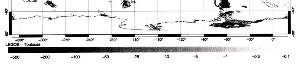
 ESA Climate Change Initiative SSH retrieval in the ice covered Arctic Ocean: from waveform classification to regional sea level maps CLS LEGOS PML Arctic SIE status 2 nd lowest on record with 4.14 10 6
QUINC2. Harvest MNPEAK MCDON4 MAZTLN HOLLAS
 Orbit analysis for the TOPEX altimeter calibration P.N.A.M. Visser 1 and C.K. Shum University of Texas at Austin Center for Space Research October 1993 Abstract Several orbits have been used in the calibration
Your web browser (Safari 7) is out of date. For more security, comfort and the best experience on this site: Update your browser Ignore
 is out of date. For more security, comfort and the best experience on this site: Update your browser Ignore") Your web browser (Safari 7) is out of date. For more security, comfort and the best experience on this site: Update your browser Ignore ALTIMETER altitude meter For the complete encyclopedic entry with
Your web browser (Safari 7) is out of date. For more security, comfort and the best experience on this site: Update your browser Ignore ALTIMETER altitude meter For the complete encyclopedic entry with
Currents and Mixing in the Southern Ocean. Sarah Gille
 Currents and Mixing in the Southern Ocean Sarah Gille Scripps Institution of Oceanography and Department of Mechanical and Aerospace Engineering UCSD, La Jolla, CA Where might AVISO gridded fields fall
52 th International Astronautical Congress 1-5 Oct 2001 / Toulouse, France
 IAF 01 B.2.10 ALTIKA : A MICRO-SATELLITE Ka-BAND ALTIMETRY MISSION J. VERRON 1, P. BAHUREL 2, E. CAUBET 3, B. CHAPRON 4, J.F. CRETAUX 5, L. EYMARD 6, C. LE PROVOST 5, P.Y. LE TRAON 7, L. PHALIPPOU 3, F.
Annex VI-1. Draft National Report on Ocean Remote Sensing in China. (Reviewed by the Second Meeting of NOWPAP WG4)
") UNEP/NOWPAP/CEARAC/WG4 2/9 Page1 Draft National Report on Ocean Remote Sensing in China (Reviewed by the Second Meeting of NOWPAP WG4) UNEP/NOWPAP/CEARAC/WG4 2/9 Page1 1. Status of RS utilization in marine
UNEP/NOWPAP/CEARAC/WG4 2/9 Page1 Draft National Report on Ocean Remote Sensing in China (Reviewed by the Second Meeting of NOWPAP WG4) UNEP/NOWPAP/CEARAC/WG4 2/9 Page1 1. Status of RS utilization in marine
B. Loomis, D. Wiese, R. S. Nerem (1) P. L. Bender (2) P. N. A. M. Visser (3)
 P. L. Bender (2) P. N. A. M. Visser (3)") Possible mission architectures for a GRACE follow-on mission including a study on upgraded instrumentation suites, and multiple satellite pairs in moderately-inclined orbits B. Loomis, D. Wiese, R. S.
Possible mission architectures for a GRACE follow-on mission including a study on upgraded instrumentation suites, and multiple satellite pairs in moderately-inclined orbits B. Loomis, D. Wiese, R. S.