Coastal Altimetry Workshop February 5-7, Supported by NOAA (Stan Wilson) NASA (Eric Lindstrom, Lee Fu)
|
|
|
- Aubrey Jackson
- 5 years ago
- Views:
Transcription
 NASA (Eric Lindstrom, Lee Fu)")
1 Coastal Altimetry Workshop February 5-7, 2008 Organized by: Laury Miller, Walter Smith: NOAA/NESDIS Ted Strub, Amy Vandehey: CIOSS/COAS/OSU With help from many of you! Supported by NOAA (Stan Wilson) NASA (Eric Lindstrom, Lee Fu)
2 Fundamental Simple (?) Question: How does a nadir altimeter s alongtrack estimates of range and corrections change as it moves from water to land or land to water (or passes near land)? Answers get complicated fast. In general, gridding is not the focus, but this brings in the question: What are the time and space scales that need to be resolved in the coastal ocean and of the range and correction terms?
3 Further Issues and Questions What time and space scales are associated with priority applications in the coastal ocean leads to a discussion of applications and the Programs that are supporting this research. To resolve these space scales, Dynamical models are needed to produce continuous fields that assimilate the altimeter and other data. This leads to a discussion of Integrated Ocean Observing Systems (remote sensing, in situ data and models).

4 Meeting Objectives Develop a new error budget specifically for the coastal ocean for the alongtrack signals. Identify specific problems where progress can be made in improving the alongtrack estimates of range and corrections in the region next to the coast. Form partnerships and collaborations to work on these. How do we do this? Through the new OST Science Teams? Through the various Europeans initiatives? In doing this, provide information and recommendations to the agencies and programs which will be reprocessing the historical data for better coastal coverage.
5 Error budget slides for intro/overview By Walter Smith for Ted Strub
6 Altimeter corrections
7 Absolute & Relative Errors The error budget for an absolute height measurement must include all the error sources at left. Are there applications (surface geostrophic currents, detecting fronts, transport) where only a height gradient, or relative change in height, is required? If the spatial correlation scale of a height error is longer than the width of a height gradient signal, then that error is not significant for detecting the gradient of interest. Height gradients are much more accurate than heights.
. For comparison, 0.")
8 Example: wet delay correction Maximum IWV Gradient: 4 mm IWV per 40 km There are 6.36 mm of Ku-band radar correction for each 1 mm of IWV. Correction is 6 to 19 cm, but max. gradient in correction is 0.6 mm per km (μrad). For comparison, 0.6 μrad of dynamic height gradient is 6 mm/sec geostrophic velocity at mid-latitudes.
9 Example: sea state bias The sea state bias correction is ~2% of SWH. If the SWH correlation scale is such that a 1 meter change in SWH is spread over 20 km or more, then the gradient of the SSB correction is 1 μrad or less. SWH values separated by 20 km are expected to differ by no more than 0.2 m [F. Monaldo, JGR, 93 C(3), 1988, at page 2292]. Thus the expected gradient in the SSB correction is ~0.2 mm/km (2 mm/sec equivalent geostrophic velocity at mid lat.). We need not care about the details of the SSB correction if the SWH field is smooth and we are only interested in height changes, not absolute heights.

10 Example: tides 15 cm of error in semi-diurnal tide height may give us only 1 μrad error of height gradient in 50 meters depth, where a simple theory holds.
11 Example: Geoid or MSS The geoid gradient over trenches can be 300 μrad. Thus near the coasts of Central and South America, Japan, the Philippines and Indonesia, a 1 km shift in an altimeter track can introduce a geoid change of 30 cm. In these areas one must account for the displacement of each altimeter track from the mean repeat track, and the errors in the geoid or MSS may be the dominant term in the height error budget.
12 Error budget for height and slope Signal or Error Source Half-Wavelength Scale (km) Height (cm) Slope (μrad) Single 6-Year Measurement Average ABYSS signal 6 to to to to 300 Height error sources Orbit height errors, 1-σ a 10,000 to 20, <0.2 <0.1 Ionosphere (Imel, 1994; Yale, 1997) > <0.22 <0.1 SWH-induced precision error >20 (See F.2.4.2, F.2.4.3, and Table F-4) *Wet troposphere (Chelton et al., 2001) >100 3 to 6 <0.6 <0.3 *Sea-state bias (Monaldo, 1988) >20 <0.6 <0.3 <0.1 Inverse barometer (Ponte, 1994; Gill, 1982) >1000 <14 <0.14 <0.07 Oceanographic error sources Basin-scale circulation (steady) (Fu & Chelton, 2001) > <1 <1 El Ni o (Picaut & Busalacchi, 2001), other b > <0.2 <0.1 Deep ocean tide model errors (Chelton et al., 2001; > <0.03 <0.01 Shum et al., 2001) Coastal tide model errors (Shum et al., 2001; Yale, 50 to 100 <13 <2.6 < ) Eddies, Mesoscale Variability (Le Traon & Morrow, 60 to to to 5 1 to ) Meandering jet (Gulf Stream) (Fu & Chelton, 2001; 100 to to to 10 2 to 4 Smith & Sandwell, 1995) Steady jet (Florida Current) (Fu & Chelton, 2001; to to 10 5 to 10 Smith & Sandwell, 1995) a At the ABYSS antenna phase center (see section G.4.1.2). Interannual variability, planetary waves. *Bold type indicates height error constituents that are pertinent to ABYSS (see section F.2.4). From ABYSS proposal (peer-reviewed by NASA in 2001)
13
14
15
16
17
18
19

20 What do real altimeters see in the region next to the coast? Jason-1 data on tracks 247 and 28 are being extended closer to the coast by substituting ECMWF water vapor for the microwave radiometer wet tropo correction.


21 Jason-1 Pass 28, Cycle 130: July 18, 2005

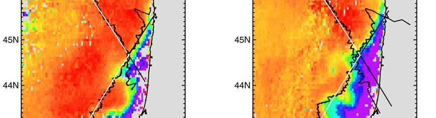


22 Extending the Altimeter Alongtrack SSH to the Coast 2005 ~ July 18 ~ July 28 ~ August 27
23 Wet Troposphere Corrections from Jason Microwave, NCEP & ECMWF Pass 28, Cycle 130 Pass 28, Cycle 131 Wet tropo (ECMWF) Dry Tropo (ECMWF) Wet tropo (ECMWF) Dry Tropo (ECMWF) cm cm cm cm E longitude E longitude E longitude E longitude 0 Wet tropo (NCEP) -220 Dry Tropo (NCEP) -5 Wet tropo (NCEP) -220 Dry Tropo (NCEP) cm cm cm -15 cm E longitude E longitude pass 28 cycle 130 Jul corrected FES04 tide Oct E longitude E longitude pass 28 cycle 131 Jul corrected FES04 tide
P. Cipollini, H. Snaith - A short course on Altimetry. Altimetry 2 - Data processing (from satellite height to sea surface height)
") P. Cipollini, H. Snaith - A short course on Altimetry Altimetry 2 - Data processing (from satellite height to sea surface height) 1 2 Satellite height to sea surface height The altimeter measures the altitude
P. Cipollini, H. Snaith - A short course on Altimetry Altimetry 2 - Data processing (from satellite height to sea surface height) 1 2 Satellite height to sea surface height The altimeter measures the altitude
Active microwave systems (2) Satellite Altimetry * the movie * applications
 Satellite Altimetry * the movie * applications") Remote Sensing: John Wilkin wilkin@marine.rutgers.edu IMCS Building Room 211C 732-932-6555 ext 251 Active microwave systems (2) Satellite Altimetry * the movie * applications Altimeters (nadir pointing
Remote Sensing: John Wilkin wilkin@marine.rutgers.edu IMCS Building Room 211C 732-932-6555 ext 251 Active microwave systems (2) Satellite Altimetry * the movie * applications Altimeters (nadir pointing
Supplementary material to Challenges in Coastal Satellite Radar Altimetry
 Supplementary material to Challenges in Coastal Satellite Radar Altimetry Published 30 June 2009 Jérôme Benveniste, European Space Agency Center for Earth Observation (ESRIN), Frascati, Italy Stefano Vignudelli,
Near Real-Time Alongtrack Altimeter Sea Level Anomalies: Options. Corinne James and Ted Strub Oregon State University. Motivation
 Near Real-Time Alongtrack Altimeter Sea Level Anomalies: Options Corinne James and Ted Strub Oregon State University Motivation Modelers want easy access to alongtrack SSHA, SLA or ADT, with enough explanations
D2.1 Product Validation Plan (PVP)
") Consortium Members ESA Sea Level CCI D2.1 Product Validation Plan (PVP) Reference: Nomenclature: CLS-DOS-NT-10-278 SLCCI-PVP-005 Issue: 1. 1 Date: Oct. 11, 11 CLS-DOS-NT-10-278 SLCCI-PVP-005 Issue 1.1
Consortium Members ESA Sea Level CCI D2.1 Product Validation Plan (PVP) Reference: Nomenclature: CLS-DOS-NT-10-278 SLCCI-PVP-005 Issue: 1. 1 Date: Oct. 11, 11 CLS-DOS-NT-10-278 SLCCI-PVP-005 Issue 1.1
High resolution geoid from altimetry & bathymetry: requirements for a future mission
 High resolution geoid from altimetry & bathymetry: requirements for a future mission The GRAL team: J-Y Royer 1,2, M-F Lalancette 3, G Louis 1,2, M Maia 1,2, D Rouxel 3 & L Géli 4 Project funded by 1 2
1 The satellite altimeter measurement
 1 The satellite altimeter measurement In the ideal case, a satellite altimeter measurement is equal to the instantaneous distance between the satellite s geocenter and the ocean surface. However, an altimeter
Study of Sea Level Variation of Exclusive Economic Zone of Malaysia. Universiti Teknologi Malaysia Skudai, Johor
 Study of Sea Level Variation of Exclusive Economic Zone of Malaysia Kamaludin Omar 1, Shahrum Ses 1, Marc Naeije 2, Mohamad Asrul Mustafar 1 1 Faculty of Geoinformation Science and Engineering Universiti
Presented at the FIG Congress 2018, May 6-11, 2018 in Istanbul, Turkey
 Presented at the FIG Congress 2018, May 6-11, 2018 in Istanbul, Turkey Paper ID: 9253 (Peer Review) By: Amalina Izzati Abdul Hamid, Ami Hassan Md Din & Kamaludin Mohd Omar Geomatic Innovation Research
Processing RADS Data LAXMIKANT DHAGE COAS OREGON STATE UNIVERSITY
 Processing RADS Data LAXMIKANT DHAGE COAS OREGON STATE UNIVERSITY 1 Declaration I hereby declare that the work incorporated in this project is original and carried out at the College of Oceanic and Atmospheric
Coastal Altimetry: recent developments and proposed use in the Agulhas region. Paolo Cipollini (NOCS, UK)
") Coastal Altimetry: recent developments and proposed use in the Agulhas region Paolo Cipollini (NOCS, UK) Coastal altimetry - the concept Satellite altimetry has been designed for the open ocean 15 years
Coastal Altimetry: recent developments and proposed use in the Agulhas region Paolo Cipollini (NOCS, UK) Coastal altimetry - the concept Satellite altimetry has been designed for the open ocean 15 years
Applications of an ensemble Kalman Filter to regional ocean modeling associated with the western boundary currents variations
 Applications of an ensemble Kalman Filter to regional ocean modeling associated with the western boundary currents variations Miyazawa, Yasumasa (JAMSTEC) Collaboration with Princeton University AICS Data
DERIVATION OF SEA LEVEL ANOMALY USING SATELLITE ALTIMETER. Ami Hassan Md Din, Kamaludin Mohd Omar
 DERIVATION OF SEA LEVEL ANOMALY USING SATELLITE ALTIMETER Ami Hassan Md Din, Kamaludin Mohd Omar Faculty of Geoinformation Science and Engineering Universiti Teknologi Malaysia Skudai, Johor E-mail: amihassan@utm.my
ON THE ACCURACY OF CURRENT MEAN SEA SURFACE MODELS FOR THE USE WITH GOCE DATA
 ON THE ACCURACY OF CURRENT MEAN SEA SURFACE MODELS FOR THE USE WITH GOCE DATA Ole B. Andersen 1, M-.H., Rio 2 (1) DTU Space, Juliane Maries Vej 30, Copenhagen, Denmark (2) CLS, Ramon St Agne, France ABSTRACT
Comparison of Mean Sea Surface Data For Oceanography
 Universität Stuttgart Geodätisches Institut Comparison of Mean Sea Surface Data For Oceanography Studienarbeit im Studiengang Geodäsie und Geoinformatik an der Universität Stuttgart Naomi Zimmermann Stuttgart,
The Malaysian Seas: Variation of Sea Level Observed by Tide Gauges and Satellite Altimetry. Universiti Teknologi Malaysia Skudai, Johor
 The Malaysian Seas: Variation of Sea Level Observed by Tide Gauges and Satellite Altimetry Kamaludin Omar 1, Shahrum Ses 1, Marc Naeije 2, Mohamad Asrul Mustafar 1 1 Faculty of Geoinformation Science and
Ocean currents from altimetry
 Ocean currents from altimetry Pierre-Yves LE TRAON - CLS - Space Oceanography Division Gamble Workshop - Stavanger,, May 2003 Introduction Today: information mainly comes from in situ measurements ocean
Satellite Altimetry and Earth Sciences
 Satellite Altimetry and Earth Sciences Satellite Altimetry and Earth Sciences This is Volume 69 in the INTERNATIONAL GEOPHYSICS SERIES A series of monographs and textbooks Edited by RENATA DMOWSKA, JAMES
Comparison of Sea Surface Heights Observed by TOPEX Altimeter with Sea Level Data at Chichijima
 Journal of Oceanography Vol. 52, pp. 259 to 273. 1996 Comparison of Sea Surface Heights Observed by TOPEX Altimeter with Sea Level Data at Chichijima NAOTO EBUCHI 1 and KIMIO HANAWA 2 1 Center for Atmospheric
Exploiting radar power to study oceans and climate: the rise and prospects of satellite altimetry
 Exploiting radar power to study oceans and climate: the rise and prospects of satellite altimetry Paolo Cipollini National Oceanography Centre, Southampton, UK with contributions by Peter Challenor, Ian
Effects of Unresolved High-Frequency Signals in Altimeter Records Inferred from Tide Gauge Data
 534 JOURNAL OF ATMOSPHERIC AND OCEANIC TECHNOLOGY VOLUME 19 Effects of Unresolved High-Frequency Signals in Altimeter Records Inferred from Tide Gauge Data RUI M. PONTE Atmospheric and Environmental Research,
Inter-tropical Convergence Zone (ITCZ) analysis using AIRWAVE retrievals of TCWV from (A)ATSR series and potential extension of AIRWAVE to SLSTR
 analysis using AIRWAVE retrievals of TCWV from (A)ATSR series and potential extension of AIRWAVE to SLSTR") Inter-tropical Convergence Zone (ITCZ) analysis using AIRWAVE retrievals of TCWV from (A)ATSR series and potential extension of AIRWAVE to SLSTR Enzo Papandrea (SERCO, CNR-ISAC, Enzo.Papandrea@serco.com)
Inter-tropical Convergence Zone (ITCZ) analysis using AIRWAVE retrievals of TCWV from (A)ATSR series and potential extension of AIRWAVE to SLSTR Enzo Papandrea (SERCO, CNR-ISAC, Enzo.Papandrea@serco.com)
Improved description of the ocean mesoscale variability by combining four satellite altimeters
 Please note that this is an author-produced PDF of an article accepted for publication following peer review. The definitive publisher-authenticated version is available on the publisher Web site GEOPHYSICAL
Currents and Mixing in the Southern Ocean. Sarah Gille
 Currents and Mixing in the Southern Ocean Sarah Gille Scripps Institution of Oceanography and Department of Mechanical and Aerospace Engineering UCSD, La Jolla, CA Where might AVISO gridded fields fall
Interannual trends in the Southern Ocean sea surface temperature and sea level from remote sensing data
 RUSSIAN JOURNAL OF EARTH SCIENCES, VOL. 9, ES3003, doi:10.2205/2007es000283, 2007 Interannual trends in the Southern Ocean sea surface temperature and sea level from remote sensing data S. A. Lebedev 1,2
Effect of coastal resolution on global estimates of tidal energy dissipation
 Effect of coastal resolution on global estimates of tidal energy dissipation Maialen Irazoqui Apecechea, Martin Verlaan Contents The GTSMv2.0 model Characteristics Major developments Applications Coastal
Geophysical Correction Application in Level 2 CryoSat Data Products
 ESRIN-EOP-GQ / IDEAS IDEAS-VEG-IPF-MEM-1288 Version 2.0 29 July 2014 Geophysical Correction Application in Level 2 CryoSat Data Products TABLE OF CONTENTS 1 INTRODUCTION... 3 1.1 Purpose and Scope... 3
Satellite Oceanography and Applications 2: Altimetry, scatterometry, SAR, GRACE. RMU Summer Program (AUGUST 24-28, 2015)
") Satellite Oceanography and Applications 2: Altimetry, scatterometry, SAR, GRACE RMU Summer Program (AUGUST 24-28, 2015) Altimetry 2 Basic principles of satellite altimetry Altimetry: the measurements of
Satellite Oceanography and Applications 2: Altimetry, scatterometry, SAR, GRACE RMU Summer Program (AUGUST 24-28, 2015) Altimetry 2 Basic principles of satellite altimetry Altimetry: the measurements of
Jerome Bouffard CryoSat Mission Geophysicist
 Multi-Platform validations of altimetry for monitoring the variability of Coastal fronts: Status and Updates Jerome Bouffard CryoSat Mission Geophysicist Context Applications Conclusions The North Western
Enhancing predictability of the Loop Current variability using Gulf of Mexico Hycom
 Enhancing predictability of the Loop Current variability using Gulf of Mexico Hycom Matthieu Le Hénaff (1) Villy Kourafalou (1) Ashwanth Srinivasan (1) Collaborators: O. M. Smedstad (2), P. Hogan (2),
Preparation of the SWOT Mission
 Preparation of the SWOT Mission M.Benkiran, E. Greiner, E. Rémy, P.Y. Le Traon and the Mercator Ocean team. Study done in the framework of a CNES/Mercator Ocean convention, in collaboration with CLS. GODAE
HYBRID DECADE-MEAN GLOBAL SEA LEVEL WITH MESOSCALE RESOLUTION. University of Hawaii, Honolulu, Hawaii, U.S.A.
 HYBRID DECADE-MEAN GLOBAL SEA LEVEL WITH MESOSCALE RESOLUTION Nikolai A. Maximenko 1 and Pearn P. Niiler 2 1 International Pacific Research Center, School of Ocean and Earth Science and Technology, University
Boundary Conditions, Data Assimilation and Predictability in Coastal Ocean Models
 Boundary Conditions, Data Assimilation and Predictability in Coastal Ocean Models (NOPP-CODAE/ONR) R. Samelson, J. S. Allen, G. Egbert, A. Kurapov, R. Miller S. Kim, S. Springer; B.-J. Choi (GLOBEC) College
Do altimeter wavenumber spectra agree with interior or surface. quasi-geostrophic theory?
 Do altimeter wavenumber spectra agree with interior or surface quasi-geostrophic theory? P.Y. Le Traon*, P. Klein*, Bach Lien Hua* and G. Dibarboure** *Ifremer, Centre de Brest, 29280 Plouzané, France
COMBINING ALTIMETRY AND HYDROGRAPHY FOR GEODESY
 COMBINING ALTIMETRY AND HYDROGRAPHY FOR GEODESY Helen M. Snaith, Peter G. Challenor and S Steven G. Alderson James Rennell Division for Ocean Circulation and Climate, Southampton Oceanography Centre, European
Assimilation of satellite altimetry referenced to the new GRACE geoid estimate
 GEOPHYSICAL RESEARCH LETTERS, VOL. 32, L06601, doi:10.1029/2004gl021329, 2005 Assimilation of satellite altimetry referenced to the new GRACE geoid estimate F. Birol, 1 J. M. Brankart, 1 J. M. Lemoine,
New retrieval algorithm for the wet tropospheric correction of altimetry missions
 New retrieval algorithm for the wet tropospheric correction of altimetry missions A. Rahmani, E. Obligis and L. Eymard CLS/LOCEAN MicroRad Conference March 2008 Page n 1/13 Introduction Altimeters are
S3-A Land and Sea Ice Cyclic Performance Report. Cycle No Start date: 30/09/2017. End date: 27/10/2017
 PREPARATION AND OPERATIONS OF THE MISSION PERFORMANCE CENTRE (MPC) FOR THE COPERNICUS SENTINEL-3 MISSION Start date: 30/09/2017 End date: 27/10/2017 Ref. S3MPC.UCL.PR.08-023 Contract: 4000111836/14/I-LG
RETRIEVING EXTREME LOW PRESSURE WITH ALTIMETRY
 RETRIEVING EXTREME LOW PRESSURE WITH ALTIMETRY L. Carrère (1), F. Mertz (1), J. Dorandeu (1), Y. Quilfen (2), Chung-Chi Lin (3) (1) CLS, 8-10 rue Hérmès, 31520 Ramonville St Agne (France) Email:lcarrere@cls.fr
The KMS04 Multi-Mission Mean Sea Surface.
 The KMS04 Multi-Mission Mean Sea Surface. Ole B. Andersen, Anne L. Vest and P. Knudsen Danish National Space Center. Juliane Maries Vej 30, DK-100 Copenhagen, Denmark. Email: {oa,alv,pk}@spacecenter.dk,
Global Variability of the Wavenumber Spectrum of Oceanic Mesoscale Turbulence
 802 J O U R N A L O F P H Y S I C A L O C E A N O G R A P H Y VOLUME 41 Global Variability of the Wavenumber Spectrum of Oceanic Mesoscale Turbulence YONGSHENG XU AND LEE-LUENG FU Jet Propulsion Laboratory,
VALIDATION OF ALTIMETER SIGNIFICANT WAVE HEIGHT USING WAVE GAUGE MEASUREMENT IN PACITAN COASTAL WATERS, EAST JAVA, INDONESIA
 VALIDATION OF ALTIMETER SIGNIFICANT WAVE HEIGHT USING WAVE GAUGE MEASUREMENT IN PACITAN COASTAL WATERS, EAST JAVA, INDONESIA *Yati Muliati, **Andojo Wurjanto, *** Widodo S. Pranowo * Institut Teknologi
S3 Product Notice Altimetry
 S3 Product Notice Altimetry Mission Sensor Product S3-A SRAL / MWR LAND L2 NRT, STC and NTC Product Notice ID Issue/Rev Date Version 1.0 Preparation S3A.PN-STM-L2L.06 04-April-2018 This Product Notice
Updated Results from the In Situ Calibration Site in Bass Strait, Australia
 Updated Results from the In Situ Calibration Site in Bass Strait, Australia Christopher Watson 1, Neil White 2,, John Church 2 Reed Burgette 1, Paul Tregoning 3, Richard Coleman 4 1 University of Tasmania
Thoughts on Sun-Synchronous* Altimetry
 Thoughts on Sun-Synchronous* Altimetry R. D. Ray NASA Goddard Space Flight Center 14 March 2007 * Yes, a sun-synchronous wide swath is still sun-synch! Whatʼs so bad about sun-synchronous altimetry? For
SIO 210 Problem Set 2 October 17, 2011 Due Oct. 24, 2011
 SIO 210 Problem Set 2 October 17, 2011 Due Oct. 24, 2011 1. The Pacific Ocean is approximately 10,000 km wide. Its upper layer (wind-driven gyre*) is approximately 1,000 m deep. Consider a west-to-east
Assimilation of SWOT simulated observations in a regional ocean model: preliminary experiments
 Assimilation of SWOT simulated observations in a regional ocean model: preliminary experiments Benkiran M., Rémy E., Le Traon P.Y., Greiner E., Lellouche J.-M., Testut C.E., and the Mercator Ocean team.
Report of the High-Resolution Ocean Topography Science Working Group Meeting
 Report of the High-Resolution Ocean Topography Science Working Group Meeting Edited by Dudley B. Chelton College of Oceanic and Atmospheric Sciences Oregon State University, Corvallis, Oregon Reference
Evaluating the Use of High-Frequency Radar Coastal Currents to Correct Satellite Altimetry
 University of Colorado, Boulder CU Scholar Aerospace Engineering Sciences Graduate Theses & Dissertations Aerospace Engineering Sciences Summer 7-15-2014 Evaluating the Use of High-Frequency Radar Coastal
Concurrent simulation of the eddying general circulation and tides in a global ocean model
 Concurrent simulation of the eddying general circulation and tides in a global ocean model Brian K. Arbic 1 E. Joseph Metzger 2 Alan J. Wallcraft 2 1 Department of Oceanography and Center for Ocean-Atmospheric
The CNES CLS 2015 Global Mean Sea surface
 P. Schaeffer, I. Pujol, Y. Faugere(CLS), A. Guillot, N. Picot (CNES). The CNES CLS 2015 Global Mean Sea surface OST-ST, La Rochelle, October 2016. Plan 1. Data & Processing 2. Focus on the oceanic variability
MERIS and OSCAR: Online Services for Correcting Atmosphere in Radar
 National Aeronautics and Space Administration MERIS and OSCAR: Online Services for Correcting Atmosphere in Radar Eric Fielding and Evan Fishbein Jet Propulsion Laboratory, California Inst. of Tech. Zhenhong
Pathways of eddies in the South Atlantic Ocean revealed from satellite altimeter observations
 GEOPHYSICAL RESEARCH LETTERS, VOL. 33,, doi:10.1029/2006gl026245, 2006 Pathways of eddies in the South Atlantic Ocean revealed from satellite altimeter observations Lee-Lueng Fu 1 Received 8 March 2006;
Validation Report: WP5000 Regional tidal correction (Noveltis)
") Consortium Members ESA Cryosat Plus for Oceans Validation Report: WP5000 Regional tidal correction (Noveltis) Reference: Nomenclature: CLS-DOS-NT-14-083 CP4O-WP5000-VR-03 Issue: 2. 0 Date: Jun. 20, 14
Consortium Members ESA Cryosat Plus for Oceans Validation Report: WP5000 Regional tidal correction (Noveltis) Reference: Nomenclature: CLS-DOS-NT-14-083 CP4O-WP5000-VR-03 Issue: 2. 0 Date: Jun. 20, 14
Large-scale Ocean Circulation
 Chapter 2 Large-scale Ocean Circulation Author: Gregg Jacobs 2.1 INTRODUCTION This chapter examines the observation and physics of large-scale ocean features. Physical oceanographers apply the term large-scale
Alexander Kurapov, in collaboration with R. Samelson, G. Egbert, J. S. Allen, R. Miller, S. Erofeeva, A. Koch, S. Springer, J.
 Coastal Ocean Modeling at CIOSS Alexander Kurapov, in collaboration with R. Samelson, G. Egbert, J. S. Allen, R. Miller, S. Erofeeva, A. Koch, S. Springer, J. Osborne - Pilot real-time forecast model of
NUMERICAL EXPERIMENTS USING CLOUD MOTION WINDS AT ECMWF GRAEME KELLY. ECMWF, Shinfield Park, Reading ABSTRACT
 NUMERICAL EXPERIMENTS USING CLOUD MOTION WINDS AT ECMWF GRAEME KELLY ECMWF, Shinfield Park, Reading ABSTRACT Recent monitoring of cloud motion winds (SATOBs) at ECMWF has shown an improvement in quality.
EVALUATION OF WINDSAT SURFACE WIND DATA AND ITS IMPACT ON OCEAN SURFACE WIND ANALYSES AND NUMERICAL WEATHER PREDICTION
 5.8 EVALUATION OF WINDSAT SURFACE WIND DATA AND ITS IMPACT ON OCEAN SURFACE WIND ANALYSES AND NUMERICAL WEATHER PREDICTION Robert Atlas* NOAA/Atlantic Oceanographic and Meteorological Laboratory, Miami,
Air-Sea Coupling in an Eastern Boundary Current Region
 Air-Sea Coupling in an Eastern Boundary Current Region Eric D. Skyllingstad CEOAS, Oregon State University Roger M. Samelson D. B. Chelton, A. Kurapov CEOAS, Oregon State University N. Perlin RSMAS, University
Airborne Remote Sensing for Ocean and Coastal Applications
 Airborne Remote Sensing for Ocean and Coastal Applications Ben Reineman, Luc Lenain, Nick Statom, David Castel, Ken Melville Scripps Institution of Oceanography 17 October, 2011 Address for correspondence:
HY-2A Satellite User s Guide
 National Satellite Ocean Application Service 2013-5-16 Document Change Record Revision Date Changed Pages/Paragraphs Edit Description i Contents 1 Introduction to HY-2 Satellite... 1 2 HY-2 satellite data
PROCESSES CONTRIBUTING TO THE GLOBAL SEA LEVEL CHANGE
 Second Split Workshop in Atmospheric Physics and Oceanography PROCESSES CONTRIBUTING TO THE GLOBAL SEA LEVEL CHANGE Student: Maristella Berta Mentor: Prof. Stjepan Marcelja Split, 24 May 2010 INTRODUCTION
Preliminary Programme (090910)
") Preliminary Programme (090910) Day 1, Thursday 17 September 2009 08:00 08:30 Registration and Poster Mounting 08:30 08:50 Introduction and Objectives of the Workshop J. Benveniste, P. Cipollini, L. Miller,
Preliminary Programme (090910) Day 1, Thursday 17 September 2009 08:00 08:30 Registration and Poster Mounting 08:30 08:50 Introduction and Objectives of the Workshop J. Benveniste, P. Cipollini, L. Miller,
A New Mapping Method for Sparse Observations of Propagating Features
 A New Mapping Method for Sparse Observations of Propagating Features Using Complex Empirical Orthogonal Function Analysis for spatial and temporal interpolation with applications to satellite data (appears
On the Transition from Profile Altimeter to Swath Altimeter for Observing Global Ocean Surface Topography
 560 J O U R N A L O F A T M O S P H E R I C A N D O C E A N I C T E C H N O L O G Y VOLUME 31 On the Transition from Profile Altimeter to Swath Altimeter for Observing Global Ocean Surface Topography LEE-LUENG
Pacific HYCOM. E. Joseph Metzger, Harley E. Hurlburt, Alan J. Wallcraft, Luis Zamudio and Patrick J. Hogan
 Pacific HYCOM E. Joseph Metzger, Harley E. Hurlburt, Alan J. Wallcraft, Luis Zamudio and Patrick J. Hogan Naval Research Laboratory, Stennis Space Center, MS Center for Ocean-Atmospheric Prediction Studies,
Observations and Modeling of SST Influence on Surface Winds
 Observations and Modeling of SST Influence on Surface Winds Dudley B. Chelton and Qingtao Song College of Oceanic and Atmospheric Sciences Oregon State University, Corvallis, OR 97331-5503 chelton@coas.oregonstate.edu,
S3-A Land and Sea Ice Cyclic Performance Report. Cycle No Start date: 21/04/2017. End date: 18/05/2017
 PREPARATION AND OPERATIONS OF THE MISSION PERFORMANCE CENTRE (MPC) FOR THE COPERNICUS SENTINEL-3 MISSION Cycle No. 017 Start date: 21/04/2017 End date: 18/05/2017 Ref. S3MPC.UCL.PR.08-017 Contract: 4000111836/14/I-LG
North Atlantic circulation in three simulations of 1/12, 1/25, and 1/50
 North Atlantic circulation in three simulations of 1/12, 1/2, and 1/ Xiaobiao Xu and Eric Chassignet Center for ocean-atmospheric prediction studies Florida State University Motivation Numerical models
Improved Fields of Satellite-Derived Ocean Surface Turbulent Fluxes of Energy and Moisture
 Improved Fields of Satellite-Derived Ocean Surface Turbulent Fluxes of Energy and Moisture First year report on NASA grant NNX09AJ49G PI: Mark A. Bourassa Co-Is: Carol Anne Clayson, Shawn Smith, and Gary
Comparing Mesoscale Eddy to Internal Gravity Kinetic Energy from HighResolution Global Ocean Models with. Moored Current Meter Observations
 Comparing Mesoscale Eddy to Internal Gravity Kinetic Energy from HighResolution Global Ocean Models with Moored Current Meter Observations James G. Richman Florida State University/ Naval Research Laboratory
Aliasing of High-Frequency Sea Surface Height Signals in Swath Satellite Altimetry Ji Ye
 Aliasing of High-Frequency Sea Surface Height Signals in Swath Satellite Altimetry Ji Ye Abstract Satellite altimeters measure global sea surface height (SSH); a variable crucial to understanding phenomena
A global high resolution mean sea surface from multi mission satellite altimetry
 BOLLETTINO DI GEOFISICA TEORICA ED APPLICATA VOL. 40, N. 3-4, pp. 439-443; SEP.-DEC. 1999 A global high resolution mean sea surface from multi mission satellite altimetry P. KNUDSEN and O. ANDERSEN Kort
Generation and Initial Evaluation of a 27-Year Satellite-Derived Wind Data Set for the Polar Regions NNX09AJ39G. Final Report Ending November 2011
 Generation and Initial Evaluation of a 27-Year Satellite-Derived Wind Data Set for the Polar Regions NNX09AJ39G Final Report Ending November 2011 David Santek, PI Space Science and Engineering Center University
PREDICTION AND MONITORING OF OCEANIC DISASTERS USING MICROWAVE REMOTE SENSING TECHNIQUES
 PREDICTION AND MONITORING OF OCEANIC DISASTERS USING MICROWAVE REMOTE SENSING TECHNIQUES O P N Calla International Centre for Radio Science, OM NIWAS A-23, Shastri Nagar, Jodhpur-342 003 Abstract The disasters
A Factor of 2-4 Improvement in Marine Gravity and Predicted Bathymetry from CryoSat, Jason-1, and Envisat Radar Altimetry: Arctic and Coastal Regions
 DISTRIBUTION STATEMENT A. Approved for public release; distribution is unlimited. A Factor of 2-4 Improvement in Marine Gravity and Predicted Bathymetry from CryoSat, Jason-1, and Envisat Radar Altimetry:
The impact of combined assimilation of altimeters data and wave spectra from S-1A and 1B in the operational model MFWAM
 The impact of combined assimilation of altimeters data and wave spectra from S-1A and 1B in the operational model MFWAM Lotfi Aouf and Alice Dalphinet Météo-France, Département Marine et Oceanographie
On the impact of the assimilation of ASAR wave spectra in the wave model MFWAM
 On the impact of the assimilation of ASAR wave spectra in the wave model MFWAM Lotfi Aouf, Jean-Michel Lefèvre Météo-France, Toulouse SEASAR 2012, 4 th International workshop on Advances in SAR oceanography,
THE SURFACE WATER AND OCEAN TOPOGRAPHY (SWOT) MISSION
 MISSION") THE SURFACE WATER AND OCEAN TOPOGRAPHY (SWOT) MISSION Lee-Lueng Fu (1), Douglas Alsdorf (2), Erensto Rodriguez (1), Rosemary Morrow (3), Nelly Mognard (3), Juliette Lambin (4), Parag Vaze (1), and Thierry
THE SURFACE WATER AND OCEAN TOPOGRAPHY (SWOT) MISSION Lee-Lueng Fu (1), Douglas Alsdorf (2), Erensto Rodriguez (1), Rosemary Morrow (3), Nelly Mognard (3), Juliette Lambin (4), Parag Vaze (1), and Thierry
Recent improvements on the wave forecasting system of Meteo-France: modeling and assimilation aspects
 Recent improvements on the wave forecasting system of Meteo-France: modeling and assimilation aspects L. Aouf and J-M. Lefèvre Division Marine et Océanographie, Météo-France 13 th International workshop
A short course on Altimetry
 A short course on Altimetry Paolo Cipollini National Oceanography Centre, Southampton, UK cipo@noc.soton.ac.uk with contributions by Peter Challenor, Ian Robinson, Helen Snaith, R. Keith Raney + some other
Near-coastal satellite altimetry: Sea surface height variability in the North Sea Baltic Sea area
 Near-coastal satellite altimetry: Sea surface height variability in the North Sea Baltic Sea area K. S. Madsen 1,2, J. L. Høyer 2, and C. C. Tscherning 1 An edited version of this paper was published by
Variability in the Slope Water and its relation to the Gulf Stream path
 Click Here for Full Article GEOPHYSICAL RESEARCH LETTERS, VOL. 35, L03606, doi:10.1029/2007gl032183, 2008 Variability in the Slope Water and its relation to the Gulf Stream path B. Peña-Molino 1 and T.
The impact of the assimilation of altimeters and ASAR L2 wave data in the wave model MFWAM
 The impact of the assimilation of altimeters and ASAR L2 wave data in the wave model MFWAM Lotfi Aouf 1, Jean-Michel Lefèvre 1 1) Météo-France, Toulouse 12 th Wave Hindcasting and Forecasting, Big Island
Impact of Argo, SST, and altimeter data on an eddy-resolving ocean reanalysis
 Click Here for Full Article GEOPHYSICAL RESEARCH LETTERS, VOL. 34, L19601, doi:10.1029/2007gl031549, 2007 Impact of Argo, SST, and altimeter data on an eddy-resolving ocean reanalysis Peter R. Oke 1 and
On the Wind Power Input and Eddy Residence Time
 Hamburg Workshop 215 On the Wind Power Input and Eddy Residence Time Xiaoming Zhai Centre for Ocean and Atmospheric Sciences School of Environmental Sciences, University of East Anglia With David Marshall,
Feature resolution in OSTIA L4 analyses. Chongyuan Mao, Emma Fiedler, Simon Good, Jennie Waters, Matthew Martin
 Feature resolution in OSTIA L4 analyses Chongyuan Mao, Emma Fiedler, Simon Good, Jennie Waters, Matthew Martin GHRSST XVIII, Qingdao, China, 5-9 June 2017 Talk outline Introduction NEMOVAR in OSTIA Methods
Investigate the influence of the Amazon rainfall on westerly wind anomalies and the 2002 Atlantic Nino using QuikScat, Altimeter and TRMM data
 Investigate the influence of the Amazon rainfall on westerly wind anomalies and the 2002 Atlantic Nino using QuikScat, Altimeter and TRMM data Rong Fu 1, Mike Young 1, Hui Wang 2, Weiqing Han 3 1 School
Effects of Eddy Variability on the Circulation of the Japan/ East Sea
 Journal of Oceanography, Vol. 55, pp. 247 to 256. 1999 Effects of Eddy Variability on the Circulation of the Japan/ East Sea G. A. JACOBS 1, P. J. HOGAN 1 AND K. R. WHITMER 2 1 Naval Research Laboratory,
COMBAT CMEMS Service Evolution 2 KOM Visio-conference, 16 April AZTI. Todos los derechos reservados
 COMBAT CMEMS Service Evolution 2 KOM Visio-conference, 16 April 2018 INDEX CONTEXT OBJECTIVES TEAM ORGANIZATION IMPACT AND RELEVANCE OF THE PROJECT FOR CMEMS PLAN TO INTERACT WITH TACs AND MFCs CONTEXT
SIO 210 Final Exam December 10, :30 2:30 NTV 330 No books, no notes. Calculators can be used.
 SIO 210 Final Exam December 10, 2003 11:30 2:30 NTV 330 No books, no notes. Calculators can be used. There are three sections to the exam: multiple choice, short answer, and long problems. Points are given
Studies of Austfonna ice cap (Svalbard) using radar altimetry with other satellite techniques
 using radar altimetry with other satellite techniques") 15 Years of progress in Radar Altimetry Symposium Ocean surface topography science team (OSTST) International Doris Service (IDS) Workshop, Argo Workshop 13-18 March 2006, Venice, Italy Alexei V. Kouraev,
15 Years of progress in Radar Altimetry Symposium Ocean surface topography science team (OSTST) International Doris Service (IDS) Workshop, Argo Workshop 13-18 March 2006, Venice, Italy Alexei V. Kouraev,
Geography of the world s oceans and major current systems. Lecture 2
 Geography of the world s oceans and major current systems Lecture 2 WHY is the GEOMORPHOLOGY OF THE OCEAN FLOOR important? (in the context of Oceanography) WHY is the GEOMORPHOLOGY OF THE OCEAN FLOOR important?
APPENDIX 2 OVERVIEW OF THE GLOBAL PRECIPITATION MEASUREMENT (GPM) AND THE TROPICAL RAINFALL MEASURING MISSION (TRMM) 2-1
 AND THE TROPICAL RAINFALL MEASURING MISSION (TRMM) 2-1") APPENDIX 2 OVERVIEW OF THE GLOBAL PRECIPITATION MEASUREMENT (GPM) AND THE TROPICAL RAINFALL MEASURING MISSION (TRMM) 2-1 1. Introduction Precipitation is one of most important environmental parameters.
APPENDIX 2 OVERVIEW OF THE GLOBAL PRECIPITATION MEASUREMENT (GPM) AND THE TROPICAL RAINFALL MEASURING MISSION (TRMM) 2-1 1. Introduction Precipitation is one of most important environmental parameters.
OSE/OSSEs at NOAA. Eric Bayler NOAA/NESDIS/STAR
 OSE/OSSEs at NOAA Eric Bayler NOAA/NESDIS/STAR OSE/OSSEs at NOAA NOAA Leadership view: Relatively inexpensive way to: Assess the impact of potential new observations Refine and redirect current observing
Geoid and MDT of the Arctic Ocean
 Geoid and MDT of the Arctic Ocean Rene Forsberg, Henriette Skourup Geodynamics Dept National Space Institute Techical University of Denmark rf@space.dtu.dk Outline: Determination of MDT from remote sensing
Global Edited Soundings for Gravity/Bathymetry Calibration
 Global Edited Soundings for Gravity/Bathymetry Calibration David Sandwell, Walter Smith, JJ Becker, Karen Marks, Megan Jones, Adrienne Apacile, Seung-Hee Kim, Scott Nelson Rob Beaman,... Objective - construct
Vertical velocities in the upper ocean from glider and altimetry data 1
 Vertical velocities in the upper ocean from glider and altimetry data 1 In this poster we show results on the combination of new glider technology data with altimetry observations to diagnose vertical
The GOCE User Toolbox
 The GOCE User Toolbox Jérôme Benveniste - ESA Earth Observation Science and Applications Department Per Knudsen - Danish National Space Center and the GUT TEAM 37th COSPAR Scientific Assembly 2008, Montreal
Robert Weaver, Donald Slinn 1
 1 1 Robert Weaver, Donald Slinn 1 Department of Civil and Coastal Engineering, University of Florida, Gainesville, Florida Supported by the US Office of Naval Research AGU Fall Meeting 2002 Poster OS72A-0342