Evaluation of height network in Latvia
|
|
|
- Gabriella Lawrence
- 5 years ago
- Views:
Transcription
1 Evaluation of height network in Latvia Kaminskis J. (,), Balodis J. (), Janpaule I. (,), Normand M. (,), Rubans A. (), Silabriedis G. (,), Zvirgzds J. (,) AFFILIATION: () Riga Technical University; () Institute of Geodesy and Geoinformation, University of Latvia; () Latvian Geospatial Information Agency; () Rigas GeoMetrs Ltd.
2 OUTLINE.Levelling campaigns in Riga city.height determination of levelling benchmarks.the control measuring campaign using EUPOS Riga and LATPOS RTK network.. The daily result distribution during two month period (Jan-Feb, ).. The LATPOS base station OJARS. Hourly result distribution during day period September.. Preliminary results.. The st order levelling benchmark monumentation in Latvia.. The control measuring campaign using EUPOS Riga and LATPOS RTK network.. Results.Conclusion for RTK.The analysis of precise levelling and Earth s crust vertical movement.selection of zero point (reference point with zero vertical motion).the reference points of geodetic heights. Interoperability of height systems 9.Additionally re-measured EUVN points
3 . Levelling campaigns in Riga city Last nd order levelling campaign in Riga city was performed at 9-. Mainly negative vertical movement was discovered at several places comparing with levelling results of 99-. There were no levelling networks neither controlled nor developed in Riga city after 9. However, the high accuracy levelling network is still important for many civil engineering tasks and for geodetic and geophysical research purposes. The deformation of Riga levelling network may be caused by: -the vertical movement of local earth surface; -the tectonic continental and intercontinental movement of the earth core is available as well. -there are several effects of vertical movement in urban environment. -development of the new building construction; -increase of traffic intensities and -both the geologic and hydro geologic conditions in upper layers of ground are additional sources of the up or down movement of earth surface.
4 . Height determination of levelling benchmarks The vertical movement could be controlled by height determination of levelling benchmarks. Application of Global Navigation Satellite Systems (GNSS) in geodesy discovers a powerful tool for the verification and validation of the historically long time ago established geodetic levelling benchmarks. The differential GNSS and RTK methods appear very useful to identify the vertical displacement of landscape by means of inspection of the deformation of levelling networks. The criteria of Mean Sea Level not always is highly useful. The mean Baltic Sea level has risen by cm during years according the records of Riga tide gauge station. It is placed near the Daugava river estuary where the water level changes depending of the work regime at the Riga hydroelectric power station placed on the Daugava river at a distance of about km. Therefore it is rather difficult to fix the real value of mean sea level near Riga. It is influenced by the artificially changing water level of river Daugava.
")

5 . Height determination of levelling benchmarks Additional tool for the independent height determination is the application of Satellite Laser Ranging System (SLR) recently developed at the University of Latvia. The SLR is located at the centre of EUPOS Riga base station network at a distance of m from GNSS antenna (in the centre of our capital).

.")
6 . Height determination of levelling benchmarks The relevant volume of SLR ranging data will be collected and the proper height determination tests will be performed. The laser ranging accuracy of LAGEOS and other LEO satellites appears at the subcentimeter level. Date Satellite RMS cm RMS cm NP RMS cm 9.. Ajisai Jason Ajisai Ajisai Jason 9... Lageos.9. LAGEOS (d= cm)..9 Lageos....9 ERS Lageos 9.. LAGEOS visible in SLR telescope guide at a distance of km.. ENVISAT.... ERS Jason..


7 . The control measuring campaign using EUPOS Riga and LATPOS RTK networks EUPOS -Riga - base stations - distance between stations ~ km Riga's GeoMetrs Ltd. and Institute Of Geodesy and Geoinformation /University of Latvia/ LATPOS - 9 base stations - distance between stations ~ km Latvian Geospatial Information Agency
 EUPOS-Riga antennas calibrated Lu ( Northing ) RMS=, mm Lu ( Easting ) RMS=, mm Lu ( Up ) RMS=, mm Centre (LU) N, E, U: STDV mm ={.")
8 S S S S S 9 S S S S S S S S S NKG General Assembly.. The daily result distribution during two month period (Jan-Feb, ) EUPOS-Riga antennas calibrated Lu ( Northing ) RMS=, mm Lu ( Easting ) RMS=, mm Lu ( Up ) RMS=, mm Centre (LU) N, E, U: STDV mm ={.,.,.} Kre ( Northing ) RMS=,9 mm Kre ( Easting ) RMS=, MM Kre ( Up ) RMS=, mm North (Kre) N, E, U: STDV mm ={.9,.,.} Msk (Northing) RMS=,9 mm Msk (Easting) RMS=, mm Msk ( Up ) RMS=, mm South (Msk) N, E, U: STDV mm ={.9,.,.} Van ( Northing ) RMS=, mm Van ( Easting ) RMS=, mm Van ( Up ) RMS=, mm East (Van) N, E, U: STDV mm ={.,.,.} Series Series - - S Ann (Northing) RMS=, mm Ann (Easting) RMS=, mm Ann (Up) RMS=, mm West (Ann) N, E, U: STDV mm ={.,.,.}
9 NKG General Assembly.. The LATPOS base station OJARS. Hourly result distribution during day period September Antenna not calibrated OJARS (Northing) OJARS (Easting) 9 9 S S Series Series Series Series OJARS (Up) OJARS N, E, U: STDV mm = {.,.,.} S Series Series
10 Kre Van Lu Ann 9 T Msk 9 9 Kre Ann Differences ( cm ) Lu Van T Msk South <- North NKG General Assembly.. Preliminary results Arrangement N -> S West -> East, -, -, -, Epoch precision and reliability Rp 9 one measurement RMS=, cm ( measurements) result RMS=, mm -, -, -,
11 .. Preliminary results Preliminary results have discovered a land down lift at the bank of Riga Bay THEREFORE Further measurements and research was performed during summer.


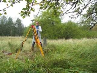
12 .. The st order levelling benchmark monumentation in Latvia Fundamental ground benchmark Ground benchmark


13 .. The control measuring campaign using EUPOS Riga and LATPOS RTK networks
14 .. Results points (st order and nd order levelling benchmarks) were measured using LEICA and TOPCON GPS receivers The sequence of results of RTK sec long sessions were collected and/or The sequence of results of RTK sec long sessions were collected


15 Collecting results of RTK sec long sessions in Riga at the Rainis monument
16 Variation in m NKG General Assembly.. Results STDV= RMS= n Results STDV RMS STDV RMS # H mm mm mm mm, 9,,,, 9,9,,,, 9,9,,,, 9,,,,9,, 9,,,,, 9,9,,,9, 9,9,,,,9,,,,, 9, 9,,,,,,,,,,, 9,,, SALA,,, T,9,,9,,,,,,,,99,99,9,9,9,9,9,9,9,,,,,, Sequence of results of RTK sec long sessions, probably influenced by ionosphere fluctuations 9 9 Sequence of results of RTK sec long sessions () Sequence of results of RTK sec long sessions (),9,9,9,9,9,9,
17 .. Results Levelling Year dh (m) Levelling Year dh (m) # st order st order nd order nd order,9 9, 9, 9, 9, -, 9, -, 9, -,,9 9, 9, -, 9, -,, 9 -, 9, 9,, -, 9, -,, -, The coherence of results (st and nd order of benchmarks; year 9,,,, ) is within cm Mainly the values with negative sign have been observed, -,,,,, 9, 9 -, SALA,9, T, 9 -,,,
18 Deformation ( m ) NKG General Assembly.. Results Control Results,,,, -, -, SALA T -, -, st order nd order
19 . Conclusion for RTK,,,,,,,, LEVELLING using traditional methods / using RTK application ~ km; ~ km; days work of levelling team week work,,, 9,,,,,
20 . The analysis of precise levelling and Earth s crust vertical movement Acquired and allowed (in blue color) discrepancies of polygons

21 . The analysis of precise levelling and Earth s crust vertical movement Earth s crust vertical movements in a year period in [mm] (represented with isolines)
 tied with sea level observation data (research of O. Jakubovskis).")
22 Scientific and historical motivation. Selection of zero point (reference point with zero vertical motion) Earth s crust movement in Baltic states (O. Jakubovskis, G. Žeļņins, I.Liešs un V. Matskovs). The results from levelling materials (9 99) tied with sea level observation data (research of O. Jakubovskis). The data of precise levelling in the territory of Latvia and Lithuania ( - 9) (research of G. Zelnins and I. Liess). The isolines of Earth s vertical movement for a year period (research of V. Matskovs)
23 . Selection of zero point (reference point with zero vertical motion) Zero line of Earth s crust vertical movement
 point The")

 and.")
24 . Selection of zero (reference point with zero vertical motion) point The fundamental benchmark is determined as the most suitable height zero point, Fr, in Sloka, its height is. m (BHS) and. m (EVRF) Difference, cm between systems
25 . The reference points of geodetic heights
26 . Interoperability of height systems The predicted height differences between BHS and EVRF
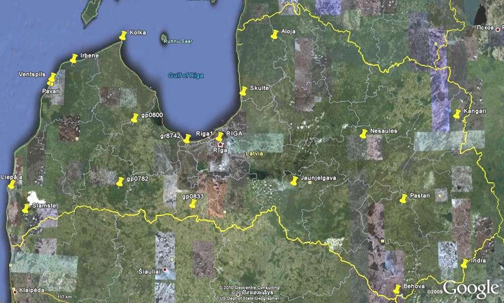
27 9. Additional measured points EUVN_DA ETRFyy ETRFyy ETRFyy LV9 EGG NKG normal height of Remarks N.p.k. Station name identifier lat lon ellipsoidal height [m] Geoid Geoid Geoid EUVN_DA station char. [deg] [deg] tide free zero tidal model model model EVRF EVRF Skulte LV,9,,, 9, 9,9 9,,, Liepaja LV,9,9,,9,,,9,, Ventspils LV,99,9,9,,,,,9, Irbene LV,,99,,9,,, 9, 9, M RIGA,99,,,,9,,,, gp LV,,99,,,,,,, gp LV,,99,,,9,,99,, gp LV,,,,9,,9,9,, 9 gr LV,99,9,,,,,,, - Aloja LV,,9,,9 9,9 9, 9,9,, Behova LV,9,,,,9,, 9, 9, Indra LV,9,,,,,, 9, 9,9 Jaunjelgava LV,9,,,9,9,, 9, 9, - Kangari LV9,99,9,, 9, 9, 9,,,9 Kolka LV,9,,9,,,9,9,99, Nesaules LV,9,9,,,,,,,9 Pastari LV,,99,,,9,9, 9,9 9,99 Pavari LV,9,9,,,,9,,, 9 Riga LV,9,9 9, 9,,9,,,, Slamste LV,,,,9,,,9,9, Mean values 9,9 9,9,,,,9, +, cm +, cm
28 9. Additional measured points Dispersion of height measurements during session KOLKA (m),,,,,,,, Ellipsoidal height =, m +, cm
29 9. Additional measured points Dispersion of height measurements during session gr (m),,,,,,,,, Ellipsoidal height =, m -, cm
30 9. Additional measured points Dispersion of height measurements during session JAUNJELGAVA (m),,,9,,,,,,,,, Ellipsoidal height =, m +, cm
31 9. Additionally measured EUVN points

32 THANK YOU FOR KIND ATTENTION!
National Report about geodetic work in Latvia
 National Report about geodetic work in Latvia EUREF 2007 London, 6th to 9th June 2007 J. Kaminskis, Department of Geodesy Latvian Geospatial Information Agency, Latvia E-mail: janis.kaminskis@lgia.gov.lv
Digital Zenith Camera for Geodetic Purposes in Latvia
 Digital Zenith Camera for Geodetic Purposes in Latvia Janis Kaminskis, Inese Janpaule, Ansis Zarins Presented by Jānis Kaminskis Development of a digital zenith telescope optical system and telescope prototype
European Vertical Reference System Influence in Latvia
 IOP Conference Series: Materials Science and Engineering PAPER OPEN ACCESS European Vertical Reference System Influence in Latvia To cite this article: A Celms et al 2015 IOP Conf. Ser.: Mater. Sci. Eng.
INTERNATIONAL SLR SERVICE
 ARTIFICIAL SATELLITES, Vol. 46, No. 4 2011 DOI: 10.2478/v10018-012-0004-z INTERNATIONAL SLR SERVICE Stanisław Schillak Space Research Centre, Polish Academy of Sciences Astrogeodynamic Observatory, Borowiec
Sciences, Moltkestrasse 30, 76133, Karlsruhe, Germany c College of Engineering and Technology, Civil and Architectural Engineering, Palestine
 This article was downloaded by: [Palestinian Polytechnic University] On: 14 April 2013, At: 00:18 Publisher: Taylor & Francis Informa Ltd Registered in England and Wales Registered Number: 1072954 Registered
New satellite mission for improving the Terrestrial Reference Frame: means and impacts
 Fourth Swarm science meeting and geodetic missions workshop ESA, 20-24 March 2017, Banff, Alberta, Canada New satellite mission for improving the Terrestrial Reference Frame: means and impacts Richard
THE SITUATION IN EASTERN EUROPE ABOUT GEOID / QUASIGEOID MODELS DETERMINATION
 THE SITUATION IN EASTERN EUROPE ABOUT GEOID / QUASIGEOID MODELS DETERMINATION Petre Iuliu DRAGOMIR, Professor, PhD Technical University of Civil Engineering Bucharest, Faculty of Geodesy, pdragomir@rdslink.ro
Observation of Landslide Movements by Geodetic and Borehole Tilt Measurements
 53 Observation of Landslide Movements by Geodetic and Borehole Tilt Measurements Mentes, Gy. and László Bányai, L. Geodetic and Geophysical Institute, Research Centre for Astronomy and Earth Sciences,
2 nd Tidal and Water Level Working Group Meeting
 2 nd Tidal and Water Level Working Group Meeting Norwegian Hydrographic Service, Stavanger, Norway 27 29 April 2010 Vertical Offshore Reference Framework (VORF) Chris Jones United Kingdom Hydrographic
Shape of the Earth. Data Output by the Receiver
 It is quite common for confusion to arise about the process used during a hydrographic survey when GPS-derived water surface elevation is incorporated into the data as an RTK Tide correction. This article
A Unique Reference Frame: Basis of the Global Geodetic Observing System (GGOS) for Geodynamics and Global Change
 for Geodynamics and Global Change") SRTM (InSAR) A Unique Reference Frame: Basis of the Global Geodetic Observing System (GGOS) for Geodynamics and Global Change Hermann Drewes President IAG Commission 1 Reference Frames Deutsches Geodätisches
SRTM (InSAR) A Unique Reference Frame: Basis of the Global Geodetic Observing System (GGOS) for Geodynamics and Global Change Hermann Drewes President IAG Commission 1 Reference Frames Deutsches Geodätisches
DETERMINATION OF THE STATION COORDINATES FOR QUALITY CONTROL OF THE SATELLITE LASER RANGING DATA S.
 DETERMINATION OF THE STATION COORDINATES FOR QUALITY CONTROL OF THE SATELLITE LASER RANGING DATA S. Schillak Space Research Centre of the Polish Academy of Sciences. Astrogeodynamic Observatory, Borowiec
Geodetic applications of GNSS in the Black Sea region
 BALGEOS II - Balkan countries integration into GGOS Second workshop, 27-29 January, 2010 Vienna - AUSTRIA Geodetic applications of GNSS in the Black Sea region Lyubka Pashova CENTRAL LABORATORY OF GEODESY
SIRGAS: Basis for Geosciences, Geodata, and Navigation in Latin America
 SIRGAS: Basis for Geosciences, Geodata, and Navigation in Latin America Claudio Brunini President of SIRGAS Universidad Nacional de La Plata, Argentina María Virginia Mackern President of SIRGAS/WG-I:
Graz in Space Graz SLR System. Daniel Kucharski. IWF / SatGeo
 Graz in Space 2008 Graz SLR System Daniel Kucharski IWF / SatGeo Satellite Laser Ranging Range measurements to the satellites - time of flight of the ultrashort laser pulses - mm precision station-satellite
ESTIMATES OF HORIZONTAL DISPLACEMENTS ASSOCIATED WITH THE 1999 TAIWAN EARTHQUAKE
 ESTIMATES OF HORIZONTAL DISPLACEMENTS ASSOCIATED WITH THE 1999 TAIWAN EARTHQUAKE C. C. Chang Department of Surveying and Mapping Engineering Chung Cheng Institute of Technology, Taiwan, ROC ABSTRACT A
Warkworth geodetic station as a potential GGOS core site in New Zealand
 "Launching the Next-Generation IVS Network Session 2: Correlators, Stations and Operations Centers. 7th IVS General Meeting March 5, 2012 Madrid, Spain Warkworth geodetic station as a potential GGOS core
BUILDING AN ACCURATE GIS
 BUILDING AN ACCURATE GIS 2006 GIS in the Rockies Denver, Colorado September 13, 2006 William E. Linzey United States Department of Commerce National Oceanic and Atmospheric Administration National Geodetic
Working Group 1. Geodetic Reference Frame. Activity Report. for. The UN-GGIM-AP Plenary Meeting
 Regional Committee of United Nations Global Geospatial Information Management for Asia and the Pacific (UN-GGIM-AP) Established by a United Nations Resolution Working Group 1 Geodetic Reference Frame Activity
NEW GEODETIC REFERENCE FRAME KOSOVAREV 01
 Bashkim IDRIZI Ismail KABASHI NEW GEODETIC REFERENCE FRAME KOSOVAREV 01 Overview: Basic data of the Republic of Kosova Geodetic referent frame before year 2001 KOSOVAREF 01 KOSOVAREF 01 1 st order Observations
Height Modernization 2013 A New Canadian Vertical Datum
 Height Modernization 2013 A New Canadian Vertical Datum What is Height Modernization? The Height Reference System Modernization is a project at the Geodetic Survey Division (GSD) of Natural Resources Canada
Specification of the Baltic Sea Chart Datum 2000 (BSCD2000)
") Specification of the Baltic Sea Chart Datum 2000 (BSCD2000) DRAFT by Jonas Ågren, Gunter Liebsch and Jyrki Mononen Version 3a, 2018-02-06 1. Definition The Baltic Sea Chart Datum 2000 (BSCD2000) is a geodetic
Specification of the Baltic Sea Chart Datum 2000 (BSCD2000) DRAFT by Jonas Ågren, Gunter Liebsch and Jyrki Mononen Version 3a, 2018-02-06 1. Definition The Baltic Sea Chart Datum 2000 (BSCD2000) is a geodetic
A new transformation including deformation model for the Nordic. and Baltic countries
 A new transformation including deformation model for the Nordic Presented at the FIG Working Week 2017, May 29 - June 2, 2017 in Helsinki, Finland and Baltic countries P. Häkli, M. Lidberg, L. Jivall,
Report for 15th PCGIAP Meeting at 18th UNRCC-AP Working Group 1 Regional Geodesy
 Report for 15th PCGIAP Meeting at 18th UNRCC-AP Working Group 1 Regional Geodesy Chairman Shigeru Matsuzaka, Japan - shigeru@gsi.go.jp Vice Chairman Prof. Pengfei Cheng, China - chengpf@casm.ac.cn John
A New Transformation Including Deformation Model for the Nordic and Baltic Countries
 A New Transformation Including Deformation Model for the Nordic and Baltic Countries Pasi HÄKLI, Finland, Martin LIDBERG, Sweden, Lotti JIVALL, Sweden, Torbjørn NØRBECH, Norway, Oddvar TANGEN, Norway,
Publ. Astron. Obs. Belgrade No. 91 (2012), REALIZATION OF ETRF2000 AS A NEW TERRESTRIAL REFERENCE FRAME IN REPUBLIC OF SERBIA
, REALIZATION OF ETRF2000 AS A NEW TERRESTRIAL REFERENCE FRAME IN REPUBLIC OF SERBIA") Publ. Astron. Obs. Belgrade No. 91 (2012), 199-206 Contributed paper REALIZATION OF ETRF2000 AS A NEW TERRESTRIAL REFERENCE FRAME IN REPUBLIC OF SERBIA D. BLAGOJEVIĆ and V. VASILIĆ Faculty of Civil Engineering,
Publ. Astron. Obs. Belgrade No. 91 (2012), 199-206 Contributed paper REALIZATION OF ETRF2000 AS A NEW TERRESTRIAL REFERENCE FRAME IN REPUBLIC OF SERBIA D. BLAGOJEVIĆ and V. VASILIĆ Faculty of Civil Engineering,
Do we need to update PNG94 to PNG2020?
 Do we need to update PNG94 to PNG2020? Richard Stanaway Quickclose Pty Ltd Robert Rosa PNG University of Technology, Lae Does PNG94 have a use by date? PNG94 is now 23 years old (reference epoch) Users
Reference Systems Realization for the Territory of Bulgaria - Status and Perspectives
 Conference and plenary meeting of the Permanent Committee on Cadastre in the European Union 13-15 March 2018, Sofia Reference Systems Realization for the Territory of Bulgaria - Status and Perspectives
Earthquake distribution is not random: very narrow deforming zones (= plate boundaries) versus large areas with no earthquakes (= rigid plate
 versus large areas with no earthquakes (= rigid plate") Earthquake distribution is not random: very narrow deforming zones (= plate boundaries) versus large areas with no earthquakes (= rigid plate interiors) Tectonic plates and their boundaries today -- continents
Earthquake distribution is not random: very narrow deforming zones (= plate boundaries) versus large areas with no earthquakes (= rigid plate interiors) Tectonic plates and their boundaries today -- continents
Next Generation Australian Datum. Permanent Committee on Geodesy, ICSM
 Next Generation Australian Datum Permanent Committee on Geodesy, ICSM 2 Presentation: Next Generation Australian Datum Trends in the geospatial sector The Geocentric Datum of Australia 1994 (GDA94) Progress
Evaluation of Transition to Updated Regional Q-geoid Model Janis KAMINSKIS
 Janis Kaminskis, Atis Vallis, Ineta Geipele, Iveta Stamure, Martins Reiniks, Una Krutova Evaluation of Transition to Updated Regional Q-geoid Model Janis KAMINSKIS Aim and tasks: The research aim is to
The Victorian Seismic Zone 2011 GNSS Campaign Data Analysis
 G E O S C I E N C E A U S T R A L I A The Victorian Seismic Zone 2011 GNSS Campaign Data Analysis G. Hu Record 2012/38 GeoCat # 74005 APPLYING GEOSCIENCE TO AUSTRALIA S MOST IMPORTANT CHALLENGES The Victorian
STUDIES OF DISPLACEMENTS OF GPS STATIONS ON POLISH COPPER BASIN AREA Alojzy Wasilewski 1, Zofia Rzepecka 1, Stanislaw Oszczak 2
 STUDIES OF DISPLACEMENTS OF GPS STATIONS ON POLISH COPPER BASIN AREA Alojzy Wasilewski 1, Zofia Rzepecka 1, Stanislaw Oszczak 2 1 Institute of Geodesy Warmia and Masuria University in Olsztyn Fax: ++48
From Global to National Geodetic Reference Frames: how are they connected and why are they needed?
 From Global to National Geodetic Reference Frames: how are they connected and why are they needed? Zuheir ALTAMIMI Institut National de l Information Géographique et Forestière, France Vice-President,
TOWARDS ROBUST LOCALIZATION OF RTK-GPS TOPOGRAPHIC SURVEYS 23
 TOWARDS ROBUST LOCALIZATION OF RTK-GPS TOPOGRAPHIC SURVEYS Jerry W. Nave, North Carolina A&T University; Tarig A. Ali, American University of Sharjah Abstract Localization is performed to fit the observed
GNSS Observations & Sea Level
 with contributions from: - Marta Marcos - Alvaro Santamaria - GNSS Observations & Sea Level Guy Wöppelmann gwoppelm@univ-lr.fr Outline: 1. Introduction 2. The importance of Vertical Land Motions 3. The
Fundamental Station Wettzell - geodetic observatory -
 Fundamental Station Wettzell - geodetic observatory - Wolfgang Schlüter Bundesamt für Kartographie und Geodäsie, Fundamental Station Wettzell Germany Radiometer Workshop, Wettzell, 10.10.06 Evolvement
The GOCE Geoid in Support to Sea Level Analysis
 The GOCE Geoid in Support to Sea Level Analysis The geoid is a very useful quantity for oceanographers Thomas Gruber Astronomical & Physical Geodesy (IAPG) Technische Universität München 1. Characteristics
Geodesy Part of the ACES Mission: GALILEO on Board the International Space Station
 Geodesy Part of the ACES Mission: GALILEO on Board the International Space Station 1 Svehla D, 2 Rothacher M, 3 Salomon C, 2 Wickert J, 2 Helm A, 2 Beyerle, G, 4 Ziebart M, 5 Dow J 1 Institute of Astronomical
Faatasi Malologa (PGSC Chair) Director Department of Lands & Survey, Tuvalu
 Director Department of Lands & Survey, Tuvalu") Seventh Session of the United Nations Committee of Experts on Global Geospatial Information Management (UN-GGIM) - 31 July -4 August 2017 Faatasi Malologa (PGSC Chair) Director Department of Lands & Survey,
Seventh Session of the United Nations Committee of Experts on Global Geospatial Information Management (UN-GGIM) - 31 July -4 August 2017 Faatasi Malologa (PGSC Chair) Director Department of Lands & Survey,
GEORED Project: GNSS Geodesy Network for Geodynamics Research in Colombia, South America. Héctor Mora-Páez
 GEORED Project: GNSS Geodesy Network for Geodynamics Research in Colombia, South America. Héctor Mora-Páez Colombian Geological Survey UNAVCO SCIENCE MEETING Feb 27 March 1, 2012 Boulder, CO, TECTONIC
Modernization of National Geodetic Datum in China *
 UNITED NATIONS E/CONF.102/IP.16 ECONOMIC AND SOCIAL COUNCIL Nineteenth United Nations Regional Cartographic Conference for Asia and the Pacific Bangkok, 29 October 1 November 2012 Item 6(b) of the provisional
The Potential of High Resolution Satellite Interferometry for Monitoring Enhanced Oil Recovery
 The Potential of High Resolution Satellite Interferometry for Monitoring Enhanced Oil Recovery Urs Wegmüller a Lutz Petrat b Karsten Zimmermann c Issa al Quseimi d 1 Introduction Over the last years land
Multi-GNSS Opportunities and Challenges
 Multi-GNSS Opportunities and Challenges School of Surveying & Spatial Information Systems Ali Al-Shaery 1,2 Shaocheng Zhang 3 Samsung Lim 1 Chris Rizos 1 1 School of Surveying and Spatial Information System,
Towards an improved ILRS TRF contribution
 Towards an improved ILRS TRF contribution Erricos C. Pavlis ILRS Analysis Coordinator JCET/ & NASA Goddard IERS Workshop on Conventions 2007 20-21 Sept. 2007, Sèvres, France Overview The ILRS Network Geometry
ZONING OF CLIMATE IN RIGA CITY
 ZONING OF CLIMATE IN RIGA CITY Anita Kalnina*, Marita Cekule**, Lita Lizuma* *Faculty of Geography and Earth Sciences, University of Latvia, Riga, Latvia ** Institute of Geodesy and Geoinformation, University
Summary of the 2012 Global Geophysical Fluid Center Workshop
 Summary of the 2012 Global Geophysical Fluid Center Workshop T. van Dam (Uni. Lux), J. Ray (NGS/NOAA), X. Collilieux (IGN) Introduction Review the history of the GGFC Discuss the 2012 Workshop Review recommendations
On the Use of Crustal Deformation Models. in the Management of ETRS89 Realizations in Fennoscandia
 On the Use of Crustal Deformation Models Presented at the FIG Working Week 2017, May 29 - June 2, 2017 in Helsinki, Finland in the Management of ETRS89 Realizations in Fennoscandia Martin Lidberg, Jonas
GG S Global Geodetic Observing System (GGOS): Status and Future. Markus Rothacher, Ruth Neilan, Hans-Peter Plag
: Status and Future. Markus Rothacher, Ruth Neilan, Hans-Peter Plag") 2020 Global Geodetic Observing System (GGOS): Status and Future Markus Rothacher, Ruth Neilan, Hans-Peter Plag GeoForschungsZentrum Potsdam (GFZ) Jet Propulsion Laboratory (JPL) University of Nevada, Reno
2020 Global Geodetic Observing System (GGOS): Status and Future Markus Rothacher, Ruth Neilan, Hans-Peter Plag GeoForschungsZentrum Potsdam (GFZ) Jet Propulsion Laboratory (JPL) University of Nevada, Reno
Gaia Astrometry Upkeeping by GNSS - Evaluation Study [GAUGES]
![Gaia Astrometry Upkeeping by GNSS - Evaluation Study [GAUGES]](/thumbs/92/109628399.jpg "Gaia Astrometry Upkeeping by GNSS - Evaluation Study [GAUGES]") Gaia Astrometry Upkeeping by GNSS - Evaluation Study [GAUGES] M. Gai, A. Vecchiato [INAF-OATo] A. Fienga, F. Vakili, J.P. Rivet, D. Albanese [OCA] Framework: Development of High Precision Astrometric Techniques
Gaia Astrometry Upkeeping by GNSS - Evaluation Study [GAUGES] M. Gai, A. Vecchiato [INAF-OATo] A. Fienga, F. Vakili, J.P. Rivet, D. Albanese [OCA] Framework: Development of High Precision Astrometric Techniques
THREE SEASONAL BEHAVIOUR OF THE BALKAN PENINSULA GNSS PERMANENT STATIONS FROM GPS SOLUTIONS
 Доклади на Българската академия на науките Comptes rendus de l Académie bulgare des Sciences Tome 66, No 1, 2013 GEOPHYSIQUE Sismologie THREE SEASONAL BEHAVIOUR OF THE BALKAN PENINSULA GNSS PERMANENT STATIONS
Final VRF grids Date: Aug 25, 2011 Author: R. Forsberg, G. Strykowski, O. Andersen
 Final VRF grids Date: Aug 25, 2011 Author: R. Forsberg, G. Strykowski, O. Andersen www.blast-project.eu 1 Authors Name Organisation Rene Forsberg National Space Institute, DTU G. Strykowski National Space
Frames for the Future New Datum Definitions for Modernization of the U.S. National Spatial Reference System
 Figure 10. Horizontal position differences (in meters) between NAD 83 and ITRF 08 at time 2022.00 (January 1, 2022). Positional differences are shown for the North American and Pacific tectonic plates.
National report of Slovakia 2016
 National report of Slovakia 2016 Branislav Droščák, Ivan Horváth, Karol Smolík 1), Marcel Mojzeš, Juraj Papčo, Ľubomíra Gerhátová, Martina Minariková 2) 1) Geodetic and Cartographic Institute Bratislava
A Strategic Plan for Geodesy in Sweden. Mikael Lilje Lars E. Engberg Geodesy Department Lantmäteriet Sweden
 A Strategic Plan for Geodesy in Sweden Mikael Lilje Lars E. Engberg Geodesy Department Lantmäteriet Sweden Our vision is to be able to meet Swedish society s needs for a homogeneous, sustainable geodetic
Geodetic Observing Systems: tools in observing the Glacial Isostatic Adjustment. Markku Poutanen Finnish Geodetic Institute
 Geodetic Observing Systems: tools in observing the Glacial Isostatic Adjustment Markku Poutanen Finnish Geodetic Institute Glacial Isostatic Adjustment Land uplift is just one consequence of the physical
Results and Analyses of Debris Tracking from Mt Stromlo
 Results and Analyses of Debris Tracking from Mt Stromlo Jizhang Sang 1, Ian Ritchie, Matt Pearson, and Craig Smith EOS Space Systems Pty Ltd, Australia Abstract In the last 2 years, EOS Space Systems has
Establishment of a Global Absolute Gravity Network
 Establishment of a Global Absolute Gravity Network H. Wilmes 1), H. Wziontek 1), R. Falk 1), J. Ihde 1), S. Bonvalot 2), R. Forsberg 3), S. Kenyon 4), L. Vitushkin 5) 1) Federal Agency for Cartography
Contributions of Geodesy to Oceanography
 Contributions of Geodesy to Oceanography B. Tapley and J. Ries Center for Space Research, The University of Texas at Austin Dynamic Planet 2005 Cairns, Australia August 22-26, 2005 August 22-26, 2005 Dynam
MODELS OF VERTICAL MOVEMENTS OF THE EARTH CRUST SURFACE IN THE AREA OF POLAND DERIVED FROM LEVELING AND GNSS DATA
 Acta Geodyn. Geomater., Vol. 9, No. 3 (167), 331 337, 2012 MODELS OF VERTICAL MOVEMENTS OF THE EARTH CRUST SURFACE IN THE AREA OF POLAND DERIVED FROM LEVELING AND GNSS DATA Bernard KONTNY 1) * and Janusz
HORIZONTAL PROJECTION PARAMETERS: DANE COUNTY COORDINATES
 Recommended RTK GPS Configuration Parameters for the City of Madison, WI Base Station Compiled by: Dan Rodman RLS, City of Madison (608)266-6674 drodman@cityofmadison.com For base station information see
Preparation for the ITRF2013. Zuheir Altamimi Xavier Collilieux Laurent Métivier IGN, France
 Preparation for the ITRF2013 Zuheir Altamimi Xavier Collilieux Laurent Métivier IGN, France 1 Outline Introduction Solicited solutions Analysis Strategy Preparation for the ITRF2013: Combination tests
GG S. Internal Vision of GGOS. Markus Rothacher. GFZ Potsdam
 Internal Vision of GGOS Markus Rothacher GFZ Potsdam GGOS Retreat DGFI in Munich February 15-16, 2006 Contents Motivation Four Levels of Products of the IAG Services: First Level: Raw Data Collection Second
Geo Referencing & Map projections CGI-GIRS 0910
 Geo Referencing & Map projections CGI-GIRS 0910 Where are you? 31UFT8361 174,7 441,2 51 58' NB 5 40' OL 2/60 Who are they? 3/60 Do geo data describe Earth s phenomena perfectly? Georeference systems ellipsoid
VALIDATION OF THE PERMANENT SCATTERERS TECHNIQUE IN URBAN AREAS
 VALIDATION OF THE PERMANENT SCATTERERS TECHNIQUE IN URBAN AREAS Alessandro Ferretti, Claudio Prati, Fabio Rocca, Carlo Colesanti Dipartimento di Elettonica e Informazione Politecnico di Milano Piazza L.
International Association of Geodesy GEODESY ACTIVITIES IN BULGARIA NATIONAL REPORT
 INTERNATIONAL ASSOCIATION OF GEODESY, BULGARIAN NATIONAL REPORT 2007 2011 International Association of Geodesy GEODESY ACTIVITIES IN BULGARIA NATIONAL REPORT 2007 2011 Prepared for the XXVth General Assembly
GRACE impact in geodesy and geophysics. R. Biancale (GRGS-CNES Toulouse), M. Diament (IPG Paris)
, M. Diament (IPG Paris)") GRACE impact in geodesy and geophysics R. Biancale (GRGS-CNES Toulouse), M. Diament (IPG Paris) Improvement of gravity models Since 2002 the GRACE mission has changed some goals in geodesy. It has become
GRACE impact in geodesy and geophysics R. Biancale (GRGS-CNES Toulouse), M. Diament (IPG Paris) Improvement of gravity models Since 2002 the GRACE mission has changed some goals in geodesy. It has become
Positioning in the Pacific Islands
 Positioning in the Pacific Islands Andrick Lal United Nations/Nepal Workshop on the Applications of Global Navigation Satellite Systems Kathmandu - Nepal 15 th December 2016 Presentation Outline Introduction
Recent GNSS Developments and Reference Frame Issues in Turkey. Onur LENK and Bahadir AKTUĞ
 Recent GNSS Developments and Reference Frame Issues in Turkey Onur LENK and Bahadir AKTUĞ General Command of Mapping onur.lenk lenk@hgk.mil.tr 1/31 GPS STUDIES İN TURKEY date back to early 1990s geodynamics-oriented
Geocentric Sea Level Changes At Tide Gauge Station In Władysławowo
 Geocentric Sea Level Changes At Tide Gauge Station In Władysławowo Adam LYSZKOWICZ and Anna BERNATOWICZ, Poland Key words: mean sea level, land uplift, time series analysis. SUMMARY Knowledge of the changes
Semi-Dynamic Datum of Indonesia
 Technical Seminar Reference Frame in Practice, Semi-Dynamic Datum of Indonesia H.Z. Abidin, A.B. Wijanarto, S.T. Wibowo, Susilo, J. Efendi Geospatial Information Agency, Indonesia (BIG) Sponsors: Page
Modernising the Northern Territory s GRS
 Modernising the Northern Territory s GRS Geospatial & GNSS CORS Forum Kuala Lumpur, Malaysia Amy Peterson; Rob Sarib DIPL Land Information Survey Services Sunday 16 October 2016 Presentation Outline Our
The European height reference system and its realizations
 The European height reference system and its realizations Martina Sacher, Gunter Liebsch EUREF symposium 2015 Tutorial Height & Gravity June 02, Leipzig, Germany Contents 1. UELN-forerunner - Steps of
Meteorology in Latvia: History and future perspectives.
 Meteorology in Latvia: History and future perspectives. Dinara Gershinkova Latvian Hidrometeorological Agency, Riga, Latvia Dinara.Gershinkova@meteo.lv Last years we see very high interest to our service
Dealing with significant differential tectonic plate velocities within an RTK-network: The case of HEPOS
 Dealing with significant differential tectonic plate velocities within an RTK-network: The case of HEPOS M. Gianniou, E. Mitropoulou, I. Stavropoulou National Cadastre and Mapping Agency S.A. Mesogion
Geo Referencing & Map projections CGI-GIRS 0910
 Geo Referencing & Map projections CGI-GIRS 0910 Where are you? 31UFT8361 174,7 441,2 51 58' NB 5 40' OL 2/60 Who are they? 3/60 Do geo data describe Earth s phenomena perfectly? Georeference systems ellipsoid
GGOS, ECGN and NGOS: Global and regional geodetic observing systems. Markku Poutanen Finish Geodetic Institute
 GGOS, ECGN and NGOS: Global and regional geodetic observing systems Markku Poutanen Finish Geodetic Institute Contents GGOS, ECGN, NGOS Why? How? Future? (geodesy) GGOS Structure GGOS Structure European
Integration of space and terrestrial techniques to study crustal deformation. Examples in northeastern Italy
 Integration of space and terrestrial techniques to study crustal deformation. Examples in northeastern Italy Susanna Zerbini Dipartimento di Fisica, University of Bologna, Italy IAG-IASPEI Joint Capacity
Update on the International Terrestrial Reference Frame (ITRF) : ITRF2014. Zuheir Altamimi
 : ITRF2014. Zuheir Altamimi") Update on the International Terrestrial Reference Frame (ITRF) : ITRF2014 Zuheir Altamimi Head of the IERS ITRF Product Center IAG Vice President IGN, France E-mail: zuheir.altamimi@ign.fr Key Points Introduction:
Update on the International Terrestrial Reference Frame (ITRF) : ITRF2014 Zuheir Altamimi Head of the IERS ITRF Product Center IAG Vice President IGN, France E-mail: zuheir.altamimi@ign.fr Key Points Introduction:
A COMPREHENSIVE ANALYSIS OF THE CAPABILITES AND LIMITATIONS OF PSI
 A COMPREHENSIVE ANALYSIS OF THE CAPABILITES AND LIMITATIONS OF PSI Rachel Holley, InSAR Surveying Consultant InSAR Surveying Team Fugro NPA Satellite Mapping Introduction Look at the capabilities and limitations
Lecture 2 Measurement Systems. GEOS 655 Tectonic Geodesy
 Lecture 2 Measurement Systems GEOS 655 Tectonic Geodesy VLBI and SLR VLBI Very Long Baseline Interferometry SLR Satellite Laser Ranging Very Long Baseline Interferometry VLBI Geometric Delay δg S Baseline
Status of spatial information in the Republic of Moldova
 AGENCY FOR LAND RELATIONS AND CADASTRE OF MOLDOVA Status of spatial information in the Republic of Moldova Vasile GRAMA, Maria OVDII, Agency for Land Relations and Cadastre ovdii@agency.cadastre.md CONTENTS
ECGN - Development of the European Combined Geodetic Network in Austria
 ECGN - Development of the European Combined Geodetic Network in Austria Diethard Ruess 1, Gelöscht: BEV Dept. Control Survey Abstract Austria takes part in the European Combined Geodetic Network - Project
Workshop on GNSS Data Application to Low Latitude Ionospheric Research May Fundamentals of Satellite Navigation
 2458-6 Workshop on GNSS Data Application to Low Latitude Ionospheric Research 6-17 May 2013 Fundamentals of Satellite Navigation HEGARTY Christopher The MITRE Corporation 202 Burlington Rd. / Rte 62 Bedford
Geog Lecture 29 Mapping and GIS Continued
 Geog 1000 - Lecture 29 Mapping and GIS Continued http://scholar.ulethbridge.ca/chasmer/classes/ Today s Lecture (Pgs 13-25, 28-29) 1. Hand back Assignment 3 2. Review of Dr. Peddle s lecture last week
Ellipsoid Hydro Datum Geoid Errors
 Ellipsoid Hydro Datum Geoid Errors Jack L. Riley Office of Coast Survey Hydrographic Systems & Technology Branch Geoid Errors via Ellipsoid Hydrography? Per datum hydro Traditional & ellipsoid referenced
Proceedings of the First International Conference on Civil Engineering, Assiut University, Volume 2, pp , October 7-8.
 Proceedings of the First International Conference on Civil Engineering, Assiut University, Volume 2, pp. 246-253, October 7-8. PRODUCTIVE GPS TOPOGRAPHIC MAPPING FOR NATIONAL DEVELOPMENT PROJECTS IN EGYPT
PROJECT FOR THE PRODUCTION OF 1/1000 SCALE BASE MAPS FROM COLOUR IMAGES USING DIGITAL CAMERAS IN BURSA METROPOLITAN AREA (BMA) IN TURKEY
 IN TURKEY") PROJECT FOR THE PRODUCTION OF 1/1000 SCALE BASE MAPS FROM COLOUR IMAGES USING DIGITAL CAMERAS IN BURSA METROPOLITAN AREA (BMA) IN TURKEY Şenol KUŞCU, M.Sait AYIK, Eray CAN, Hasan Yasar ARKAYIN, Turkey
PROJECT FOR THE PRODUCTION OF 1/1000 SCALE BASE MAPS FROM COLOUR IMAGES USING DIGITAL CAMERAS IN BURSA METROPOLITAN AREA (BMA) IN TURKEY Şenol KUŞCU, M.Sait AYIK, Eray CAN, Hasan Yasar ARKAYIN, Turkey
GNSS-specific local effects at the Geodetic Observatory Wettzell
 GNSS-specific local effects at the Geodetic Observatory Wettzell Peter Steigenberger, Urs Hugentobler, Ralf Schmid Technische Universität München (TUM) Uwe Hessels, Thomas Klügel Bundesamt für Kartographie
Torsten Mayer-Gürr Institute of Geodesy, NAWI Graz Technische Universität Graz
 GGOS and Reference Systems Introduction 2015-10-12 Torsten Mayer-Gürr Institute of Geodesy, NAWI Graz Technische Universität Graz Torsten Mayer-Gürr 1 Course and exam Lecture Monday 14:00 16:00, A111 (ST01044)
The 2008 Local-tie Survey at the Onsala Space Observatory
 The 2008 Local-tie Survey at the Onsala Space Observatory M. Lösler, Geodetic Institute of the University of Karlsruhe (TH), DE-76128 Karlsruhe, Germany R. Haas Department of Radio and Space Science, Chalmers
TECTONIC MOVEMENTS MONITORING OF SUDETIC MARGINAL FAULT USING SHORT GPS BASELINES
 POSTER PAPER SESSION TECTONIC MOVEMENTS MONITORING OF SUDETIC MARGINAL FAULT USING SHORT GPS ASELINES ernard Kontny Department of Geodesy and Photogrammetry Agricultural University of Wroclaw, Poland Abstract
SLR Graz: khz Satellite Laser Ranging & Co
 Graz in Space 2014 KFU Graz 4. 5. September 2014 SLR Graz: khz Satellite Laser Ranging & Co Georg Kirchner, Franz Koidl, Oliver Baur Space Research Institute Austrian Academy of Sciences Outline What is
Technical Support: Data Submission
 Why do we want your data? How should I observe data for submission? The objective behind data submissions is to leverage ongoing field work to provide industry with an up-todate network of NAD83 (CSRS)
European Vertical Reference System (EVRS) 2007 a Combination of UELN and ECGN
 2007 a Combination of UELN and ECGN") European Vertical Reference System (EVRS) 2007 a Combination of UELN and ECGN Johannes Ihde, Martina Sacher, Jaakko Mäkinen EUREF Symposium 2006 Riga, June 2006 EUREF Symposium 2006 2 I. Objectives of
European Vertical Reference System (EVRS) 2007 a Combination of UELN and ECGN Johannes Ihde, Martina Sacher, Jaakko Mäkinen EUREF Symposium 2006 Riga, June 2006 EUREF Symposium 2006 2 I. Objectives of
Sea level changes around Thailand
 Final symposium 27 May Bangkok, Thailand Sea level changes around Thailand Marc Naeije Contents GEO2TECDI- SONG: measuring sea level around Thailand Concept of satellite altimetry Concept of tide gauges
IS THE SUDETIC MARGINAL FAULT STILL ACTIVE? RESULTS OF THE GPS MONITORING
 Acta Geodyn. Geomater.Vol.1, No.3 (135), 35-39, 2004 IS THE SUDETIC MARGINAL FAULT STILL ACTIVE? RESULTS OF THE GPS MONITORING 1996-2002 Bernard KONTNY Department of Geodesy and Photogrammetry, Agricultural
Consideration of a Global Vertical Reference System (GVRS) in the IERS Conventions
 in the IERS Conventions") Consideration of a Global Vertical Reference System (GVRS) in the IERS Conventions Johannes Ihde Federal Agency for Cartography and Geodesy (BKG) Chair of IAG ICP1.2 (2003-2007) Vertical Reference Frames
Consideration of a Global Vertical Reference System (GVRS) in the IERS Conventions Johannes Ihde Federal Agency for Cartography and Geodesy (BKG) Chair of IAG ICP1.2 (2003-2007) Vertical Reference Frames
New height reference surfaces for Norway
 154 European Vertical System New height reference surfaces for Norway D. SOLHEIM 1 Abstract In this article the computation of height reference surfaces at Statens kartverk is described. The difference
Height systems. Rudi Gens Alaska Satellite Facility
 Rudi Gens Alaska Satellite Facility Outline Why bother about height systems? Relevant terms Coordinate systems Reference surfaces Geopotential number 2 Why bother about height systems? give a meaning to