GNSS measurements in Ulaanbaatar and its vicinity
|
|
|
- Donna Hamilton
- 5 years ago
- Views:
Transcription
1 GNSS measurements in Ulaanbaatar and its vicinity Erdenezul Danzansan Institute of Astronomy and Geophysics MAS, Ulaanbaatar, Mongolia Andrei Miroshnichenko Institute of the Earth s Crust SB RAS, Irkutsk, Russia United Nations/Russian Federation Workshop on the Applications of Global Navigation Satellite System, Krasnoyarsk, Russian Federation,18 22 May 2015


2 Outline A brief introduction seismicity of Mongolia Recent seismic activity around Ulaanbaatar area, capital of Mongolia The active faults related to this activity The research that are currently going on Analysis and preliminary result of GNSS measurement Summary

3 Seismicity of Mongolia 1905, (M=8.0) 1905 (M=8.4) 1931, (M=8.0) 1957, Ms= earthquakes with M 7 including 4 with M 8 rate of occurrence of earthquakes per one day ~ km
4 The Gobi-Altay earthquake 1957, Ms= km In 1957, Gobi_Altay earthquake (M~8.1) occurred in south Mongolia, and produced a 250 km long surface rupture along the left-lateral, strike-slip, trending Gobi-Altay Fault. The largest displacement was around 8-10 m of horizontal and 3-4 m vertical of offset
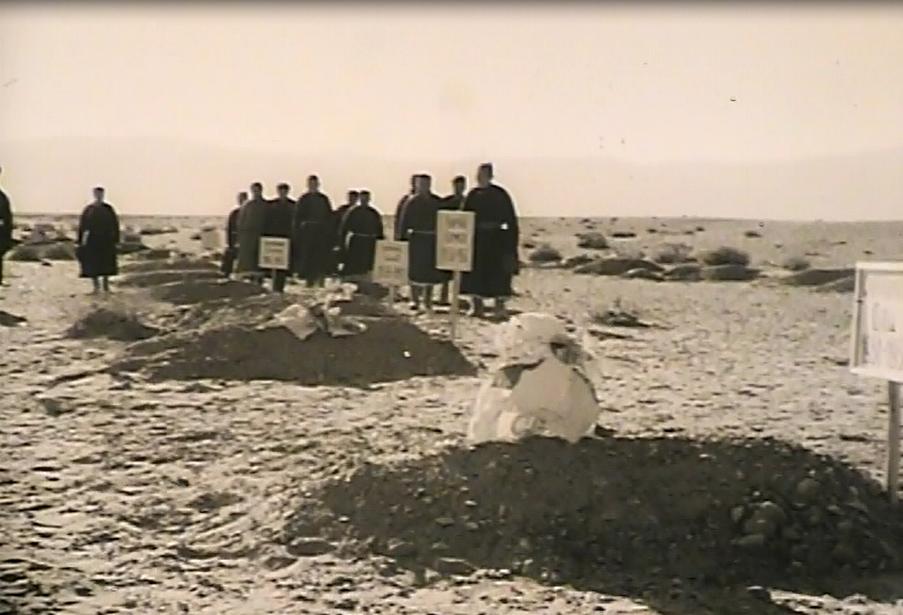

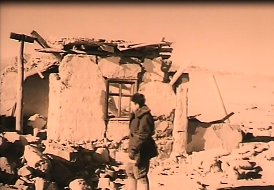


5 Casualties tens thousand cattle's 3Several villages were completely Approximately 30 people lostwiped their out livesand 5 villages suffered died severe damage.


6 Surface rupture of the Gobi-Altay earthquake

7 Recent seismic activity of Ulaanbaatar Ulaanbaatar
8 Cumulative number of earthquakes occurred between 2000 and Number of earthquakes UB

9 Seismic storm starts Cumulative numbers of earthquakes Time in years Seismic activity around Ulaanbaatar city increasing in last years and rate is changing several times during that period.


10 The active faults related to this activity Ulaanbaatar

11 Seismic hazard of Ulaanbaatar city Number of buildings are increasing rapidly. Ulaanbaatar is the capital city where is living 2/3 of the population of Mongolia. May 15 Several earthquakes has been felt in last few years. If large event occur - it will be not only for Ulaanbaatar city, it will be nation wide hazard. 11

12 GPS derived velocities with respect to Eurasia
.")
13 Previous study GPS-derived velocities with respect to Eurasia (Lukhnev A. et al, 2010).

14 Strain rates derived within the Baikal-Mongolian GPS network Blue outlined areas - elongation Red outlined areas - shortening (Lukhnev A. et al, 2010)
15 The research that are currently going on: The aim of this study is to estimate the surface velocity field and strain rate in the vicinity of Ulaanbaatar and eastern part of Mongolia. Stage 1. To install regional and local GNSS networks around Ulaanbaatar as well as in the eastern part of Mongolia. Stage 2. To carry out GNSS campaigns at the testing areas. Stage 3. To process the measurements. Stage 4. To implement the results for geodynamic models.

16 The research that are currently going on: Configurations of GNSS polygons and quantities of permanent and temporary sites are determined with regard to the geological and geomorphological structure of the areas, locations and orientations of active faults, and paleo-andrecent seismicity indicators. Three polygons are established: - East (8 sites) - Ulaanbaatar (12 sites) - Emeelt (10 sites)


17 GNSS equipments Measurements were taken by dual-frequency Trimble 5700 GPS receivers with Zephyr TRM antennas and starting from 2012, measurements at all the sites are taken by Trimble NetR9 multi-channel GNSS-receivers with ChokeRing antennas.
18 Analysis and preliminary result of GNSS measurement Measurement recording cycles lasted for 72 hours as minimum at East and Ulaanbaatar polygons, and for at least two (2) hours at Emeelt polygon. Software: GAMIT (King & Bock, 2000), GLOBK (Herring et al., 1990), FONDA (Dong et al., 1998), Calculated with: ITRF2008 IGS stations (ARTU, BADG, BJFS, CHUM, FAIR, GRAZ, IISC, IRKT, KHAJ, KIT3, KOKB, KUNM, LHAZ, MAG0, NRIL, NVSK, ONSA, PETP, PETS, POL2, SELE, SHAO, TIDB, TIXI, TSKB, ULAB, URUM, USUD, WUHN, XIAN, YAKT) Analyses of the measurement data yielded preliminary results for Ulaanbaatar polygon.
19 Horizontal velocity of the GNSS network East, Ulaanbaatar and Emeelt in ITRF2008 system and the accuracy of the measurements SITE Long. (deg) Lat. (deg) Rate E (mm/yr) Rate N (mm/yr) ± de ± dn ULAB ASGT BDRU BNTG HDUR HTBU BTSH BORU TSCH URGN TERJ HUAN WNDY GUNJ ZNMD GUNT FERM YLMT LTUG HUST EML EML EML EML EML EML EML
 to 36 mm/ yr (GUNT), and strain rates were variable within the range from 3*10-8 to 6.")
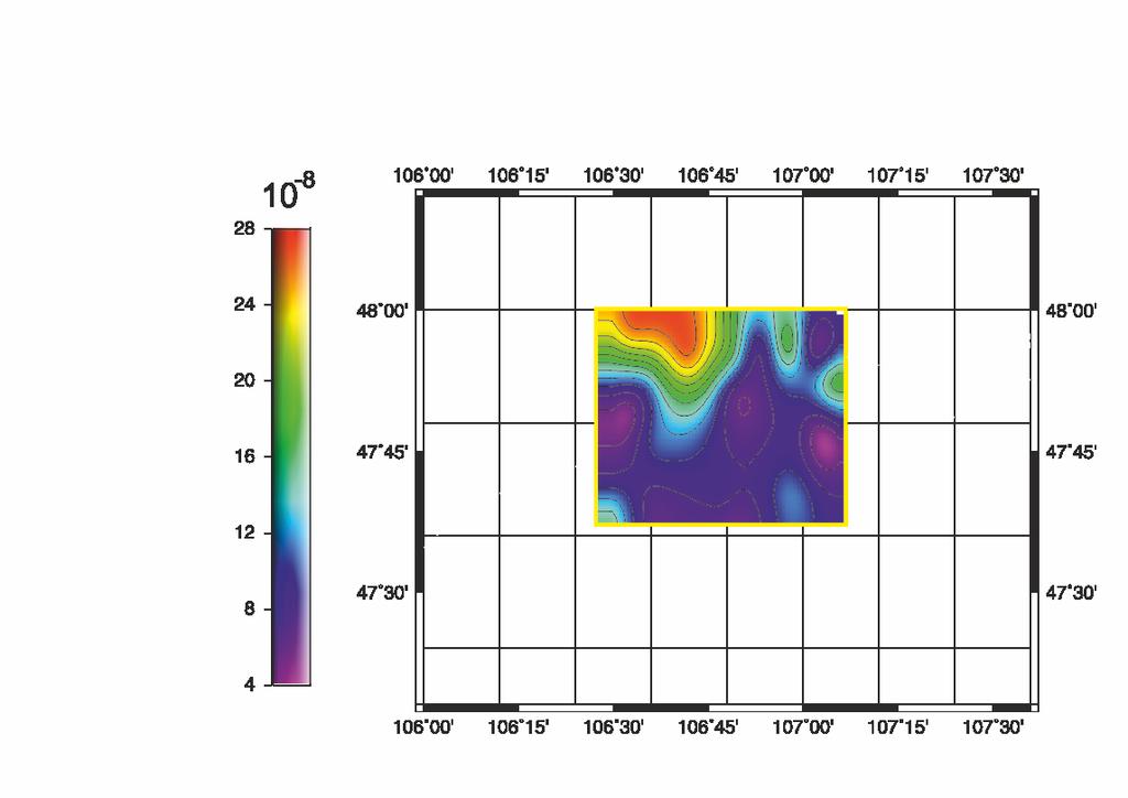
20 Preliminary results of the Ulaanbaatar polygon The sites at the polygons under study were shifted at velocities from 30 mm/yr (TERJ) to 36 mm/ yr (GUNT), and strain rates were variable within the range from 3*10-8 to 6.5*10-7 yr -1.

21 Horizontal deformation on Ulaanbaatar GNSS network

22 Preliminary results of the Emeelt polygon The sites at the polygons were shifted at velocities from 17.5 mm/yr (EML9) to 32 mm/yr (EML5) and direction of the vectors varies from 92 to 140 degrees. Such variations associated that points in the polygon "Emeelt" substantially disposed within the seismogenic structure. Accordingly, the relative deformation, manifested at the site, are characterized by considerable variation both in strain rate and types.

23 Horizontal deformation on Emeelt network


24 Horizontal velocities of the networks


25 By seismic data By GNSS measurement data


26 Seismic + GNSS data

27 Permanent GNSS stations for geodynamic application An assignment of the second stage of our program was designing and planning for network of permanent GNSS stations in Ulaanbaatar regions based on the results of first stage. Now within the second stage, we did installation of permanent stations around Ulaanbaatar region. The structure of database was developed which received from GNSS monitoring. Software development of automatic calculation, monitoring the velocity of relative deformations for earthquake prediction is beginning. Permanent GNSS station UG05 Solar panel Trimble NetR9 reciever

28 Permanent GNSS stations installed by IAG Ulaanbaatar
29 Summary ü The geodynamic networks have been designed and established in the territory of the eastern Mongolia and in the vicinity of Ulaanbaatar. Regular observations were conducted at 25 GNSS sites from 2010 to ü By results of measurements in , the preliminary sizes of modern horizontal velocities on points of the East, Ulaanbaatar and Emeelt polygons have been allowing to estimate that deformations of a terrestrial surface in the central and east regions of Mongolia. ü The method of research of geodynamic parameters fulfilled in tectonic active regions of Mongolia, and numerical values of modern deformations received by means from these methods. It will be used at an assessment of environmental, social and economic risks of development of Mongolia and Baikal regions. ü The results of measurements at the Ulaanbaatar testing area will be implemented for assessment of deformation of the Earth's surface in Ulaanbaatar and its vicinity.


30 Thank you for your attention
Extension in the Baikal Rift: Present-Day Kinematics of Passive Rifting
 ISSN 8-33X, Doklady Earth Sciences, 9, Vol. 5, No., pp. 5 9. Pleiades Publishing, Ltd., 9. Original Russian Text V.A. San kov, A.V. Lukhnev, A.I. Miroshnichenko, S.V. Ashurkov, L.M. Byzov, M.G. Dembelov,
GEORED Project: GNSS Geodesy Network for Geodynamics Research in Colombia, South America. Héctor Mora-Páez
 GEORED Project: GNSS Geodesy Network for Geodynamics Research in Colombia, South America. Héctor Mora-Páez Colombian Geological Survey UNAVCO SCIENCE MEETING Feb 27 March 1, 2012 Boulder, CO, TECTONIC
Determination of Current Velocity Field (Rate) of North Anatolian Fault in Izmit-Sapanca Segment
 of North Anatolian Fault in Izmit-Sapanca Segment") Determination of Current Velocity Field (Rate) of North Anatolian Fault in Izmit-Sapanca Segment Cetin MEKIK, Bulent TURGUT, Haluk OZENER, Turkish Republic INTRODUCTION Turkey is geologically the part
Determination of Current Velocity Field (Rate) of North Anatolian Fault in Izmit-Sapanca Segment Cetin MEKIK, Bulent TURGUT, Haluk OZENER, Turkish Republic INTRODUCTION Turkey is geologically the part
ESTIMATES OF HORIZONTAL DISPLACEMENTS ASSOCIATED WITH THE 1999 TAIWAN EARTHQUAKE
 ESTIMATES OF HORIZONTAL DISPLACEMENTS ASSOCIATED WITH THE 1999 TAIWAN EARTHQUAKE C. C. Chang Department of Surveying and Mapping Engineering Chung Cheng Institute of Technology, Taiwan, ROC ABSTRACT A
Design of Safety Monitoring and Early Warning System for Buried Pipeline Crossing Fault
 5th International Conference on Civil Engineering and Transportation (ICCET 2015) Design of Safety Monitoring and Early Warning System for Buried Pipeline Crossing Fault Wu Liu1,a, Wanggang Hou1,b *, Wentao
Slip Rates Estimate of Western North Anatolian Fault System in Turkey
 Slip Rates Estimate of Western North Anatolian Fault System in Turkey Haluk OZENER, Asli DOGRU, Bahadir AKTUG, Semih ERGINTAV, Bulent TURGUT, Onur YILMAZ, Kerem HALICIOGLU, Onur GURKAN, Turkey Keywords:
NTUA, Faculty of Rural and Surveying Engineering, Dionysos Satellite Observatory, Higher Geodesy Laboratory NOA, Institute of Geodynamics 1
 NOA, Institute of Geodynamics 1 Crustal Deformation from GPS measurements at the Ionian Sea : Preliminary Results Anastasiou 1 D., Paradissis 1 D., Ganas 2 A., Marinou 1 A., Papazissi 1 K., Drakatos 2
GPS Strain & Earthquakes Unit 5: 2014 South Napa earthquake GPS strain analysis student exercise
 GPS Strain & Earthquakes Unit 5: 2014 South Napa earthquake GPS strain analysis student exercise Strain Analysis Introduction Name: The earthquake cycle can be viewed as a process of slow strain accumulation
GEODETIC NETWORK OF SAUDI ARABIA AND FIDUCIAL STATIONS. GFN OF Saudi Arabia in Based on ITRF2000 Datum
 STUDIES OF TECTONIC MOVEMENTS IN SAUDI ARABIA USING CORS M. Al Rajhi, Ali Al Omar, R. Yanar, F. Kartal, K. Eren, SUBJECT TO TALKS BACKGROUND GEODETIC NETWORK OF SAUDI ARABIA AND FIDUCIAL STATIONS GFN OF
THREE SEASONAL BEHAVIOUR OF THE BALKAN PENINSULA GNSS PERMANENT STATIONS FROM GPS SOLUTIONS
 Доклади на Българската академия на науките Comptes rendus de l Académie bulgare des Sciences Tome 66, No 1, 2013 GEOPHYSIQUE Sismologie THREE SEASONAL BEHAVIOUR OF THE BALKAN PENINSULA GNSS PERMANENT STATIONS
Principles of the Global Positioning System Lecture 23
 12.540 Principles of the Global Positioning System Lecture 23 Prof. Thomas Herring 05/12/03 12.540 Lec 23 1 OVERVIEW Run through HW 03. Final lecture: Application area and GPS results Analysis of contemporary
12/07/2013. Apparent sea level rise and earthquakes
 Main collaborations: - P. Simeoni - M. N. Bouin - S. Calmant Valérie Ballu Valerie.ballu@univ-lr.fr Apparent sea level rise and earthquakes possibly the world s first community to be formally moved out
GPS measurements of current crustal movements along the Gulf of Suez, Egypt.
 GPS measurements of current crustal movements along the Gulf of Suez, Egypt. Presented By Nadia Abo-Ali Assistant Researcher At National Research Institute of Astronomy and Geophysics (NRIAG), Helwan,
From Earthquakes to Mountains: the Earth s Crust in Motion
 Dean s Freshman Honor Seminar (SCI 110) Eric Calais Associate Professor of Geophysics Purdue University Department of Earth and Atmospheric Sciences ecalais@purdue.edu http:/www.eas.purdue.edu/~calais
SCIENCE CHINA Earth Sciences. Preseismic deformation in the seismogenic zone of the Lushan M S 7.0 earthquake detected by GPS observations
 SCIENCE CHINA Earth Sciences RESEARCH PAPER September 2015 Vol.58 No.9: 1592 1601 doi: 10.1007/s11430-015-5128-0 Preseismic deformation in the seismogenic zone of the Lushan M S 7.0 earthquake detected
GPS measurements of crustal deformation in the Baikal-Mongolia area ( ): Implications for current kinematics of Asia
: Implications for current kinematics of Asia") JOURNAL OF GEOPHYSICAL RESEARCH, VOL. 108, NO. B10, 2501, doi:10.1029/2002jb002373, 2003 GPS measurements of crustal deformation in the Baikal-Mongolia area (1994 2002): Implications for current kinematics
JOURNAL OF GEOPHYSICAL RESEARCH, VOL. 108, NO. B10, 2501, doi:10.1029/2002jb002373, 2003 GPS measurements of crustal deformation in the Baikal-Mongolia area (1994 2002): Implications for current kinematics
Current Seismic Hazard Assessment and Creation of Early Warning System in the Republic of Armenia
 Current Seismic Hazard Assessment and Creation of Early Warning System in the Republic of Armenia Dr. Alvaro Antonyan, Dr. Valeri Arzumanyan National Survey for Seismic Protection Agency (NSSP) Ministry
How GNSS CORS in Japan works for geodetic control and disaster mitigations
 ICG Working Group D Reference Frames, Timing and Applications How GNSS CORS in Japan works for geodetic control and disaster mitigations ICG11, Nov. 7-11, 2016, Sochi, Russia Hiromichi TSUJI Geodetic Observation
Lab 9: Satellite Geodesy (35 points)
") Lab 9: Satellite Geodesy (35 points) Here you will work with GPS Time Series data to explore plate motion and deformation in California. This lab modifies an exercise found here: http://www.unavco.org:8080/cws/pbonucleus/draftresources/sanandreas/
Lab 9: Satellite Geodesy (35 points) Here you will work with GPS Time Series data to explore plate motion and deformation in California. This lab modifies an exercise found here: http://www.unavco.org:8080/cws/pbonucleus/draftresources/sanandreas/
IS THE SUDETIC MARGINAL FAULT STILL ACTIVE? RESULTS OF THE GPS MONITORING
 Acta Geodyn. Geomater.Vol.1, No.3 (135), 35-39, 2004 IS THE SUDETIC MARGINAL FAULT STILL ACTIVE? RESULTS OF THE GPS MONITORING 1996-2002 Bernard KONTNY Department of Geodesy and Photogrammetry, Agricultural
Journal of Geophysical Research Letters Supporting Information for
 Journal of Geophysical Research Letters Supporting Information for InSAR observations of strain accumulation and fault creep along the Chaman Fault system, Pakistan and Afghanistan H. Fattahi 1, F. Amelung
Can geodetic strain rate be useful in seismic hazard studies?
 Can geodetic strain rate be useful in seismic hazard studies? F. Riguzzi 1, R. Devoti 1, G. Pietrantonio 1, M. Crespi 2, C. Doglioni 2, A.R. Pisani 1 Istituto Nazionale di Geofisica e Vulcanologia 2 Università
Report for 15th PCGIAP Meeting at 18th UNRCC-AP Working Group 1 Regional Geodesy
 Report for 15th PCGIAP Meeting at 18th UNRCC-AP Working Group 1 Regional Geodesy Chairman Shigeru Matsuzaka, Japan - shigeru@gsi.go.jp Vice Chairman Prof. Pengfei Cheng, China - chengpf@casm.ac.cn John
Micro-plate tectonics and kinematics in Northeast Asia inferred from a dense set of GPS observations
 Earth and Planetary Science Letters 257 (2007) 486 496 www.elsevier.com/locate/epsl Micro-plate tectonics and kinematics in Northeast Asia inferred from a dense set of GPS observations Shuanggen Jin a,b,,
Case study of Japan: Reference Frames in Practice
 Case study of Japan: Reference Frames in Practice Basara Miyahara and Koji Matsuo Sponsors: 1 Outline Introduction - Geodetic reference frame of Japan - GEONET : continuous GNSS observation system Geometric
The Victorian Seismic Zone 2011 GNSS Campaign Data Analysis
 G E O S C I E N C E A U S T R A L I A The Victorian Seismic Zone 2011 GNSS Campaign Data Analysis G. Hu Record 2012/38 GeoCat # 74005 APPLYING GEOSCIENCE TO AUSTRALIA S MOST IMPORTANT CHALLENGES The Victorian
Case Study of Japan: Crustal deformation monitoring with GNSS and InSAR
 Technical Seminar Reference Frame in Practice, Case Study of Japan: Crustal deformation monitoring with GNSS and InSAR Basara Miyahara miyahara-b96ip@milt.go.jp Geospatial Information Authority of Japan
GPS study of N-S trending Karaburun Belt (Turkey) and its E-W trending eastern part
 and its E-W trending eastern part") Presented at the FIG Working Week 2017, GPS study of N-S trending Karaburun Belt (Turkey) and its E-W trending eastern part May 29 - June 2, 2017 in Helsinki, Finland Muzaffer KAHVECİ Selcuk University,
Presented at the FIG Working Week 2017, GPS study of N-S trending Karaburun Belt (Turkey) and its E-W trending eastern part May 29 - June 2, 2017 in Helsinki, Finland Muzaffer KAHVECİ Selcuk University,
Coupling on the MHT - Supplementary material
 Coupling on the MHT - Supplementary material February, S. Map of the GPS network Figure S: Map indicating the names and position of the continuous GPS stations used in this study to determine the pattern
Tectonics of the terrestrial litosphere in spherical harmonics
 Journal of Physics: Conference Series PAPER OPEN ACCESS Tectonics of the terrestrial litosphere in spherical harmonics To cite this article: A V Mokhnatkin et al 2016 J. Phys.: Conf. Ser. 769 012007 View
The Ohio State University IGS LEO/GPS Pilot Project: Status and Future Plans
 The Ohio State University IGS LEO/GPS Pilot Project: Status and Future Plans Dorota Brzezinska, Jay Kwon and C. K. Shum Department of Civil and Environmental Engineering and Geodetic Science OSU The Ohio
SIRGAS: Basis for Geosciences, Geodata, and Navigation in Latin America
 SIRGAS: Basis for Geosciences, Geodata, and Navigation in Latin America Claudio Brunini President of SIRGAS Universidad Nacional de La Plata, Argentina María Virginia Mackern President of SIRGAS/WG-I:
Publ. Astron. Obs. Belgrade No. 91 (2012), REALIZATION OF ETRF2000 AS A NEW TERRESTRIAL REFERENCE FRAME IN REPUBLIC OF SERBIA
, REALIZATION OF ETRF2000 AS A NEW TERRESTRIAL REFERENCE FRAME IN REPUBLIC OF SERBIA") Publ. Astron. Obs. Belgrade No. 91 (2012), 199-206 Contributed paper REALIZATION OF ETRF2000 AS A NEW TERRESTRIAL REFERENCE FRAME IN REPUBLIC OF SERBIA D. BLAGOJEVIĆ and V. VASILIĆ Faculty of Civil Engineering,
Publ. Astron. Obs. Belgrade No. 91 (2012), 199-206 Contributed paper REALIZATION OF ETRF2000 AS A NEW TERRESTRIAL REFERENCE FRAME IN REPUBLIC OF SERBIA D. BLAGOJEVIĆ and V. VASILIĆ Faculty of Civil Engineering,
National Seismological Centre: An Overview, Prospects and Challenges
 National Seismological Centre: An Overview, Prospects and Challenges By Soma Nath Sapkota Department of Mines and Geology National Seismological Centre Nepal India Himalaya Tibetan Plateau India continental
RESEARCH CENTRE OF ASTRONOMY & GEOPHYSICS OF MONGOLIAN ACADEMY OF SCIENCES. Seismicity of Mongolia and activity around Ulaanbaatar city
 RESEARCH CENTRE OF ASTRONOMY & GEOPHYSICS OF MONGOLIAN ACADEMY OF SCIENCES Seismicity of Mongolia and activity around Ulaanbaatar city Topic. Brief information about Mongolia Development of Seismology
S e i s m i c W a v e s
 Project Report S e i s m i c W a v e s PORTLAND STATE UNIVERSITY PHYSICS 213 SPRING TERM 2005 Instructor: Dr. Andres La Rosa Student Name: Prisciliano Peralta-Ramirez Table Of Contents 1. Cover Sheet 2.
GROUND SURFACE VISUALIZATION USING RED RELIEF IMAGE MAP FOR A VARIETY OF MAP SCALES
 GROUND SURFACE VISUALIZATION USING RED RELIEF IMAGE MAP FOR A VARIETY OF MAP SCALES T. Chiba a, B. Hasi a * a Asia Air Survey Co., Ltd., Kawasaki, Japan (has.baator, ta.chiba,)@ajiko.co.jp Commission II,
Earthquakes. Forces Within Eartth. Faults form when the forces acting on rock exceed the rock s strength.
 Earthquakes Vocabulary: Stress Strain Elastic Deformation Plastic Deformation Fault Seismic Wave Primary Wave Secondary Wave Focus Epicenter Define stress and strain as they apply to rocks. Distinguish
Section Forces Within Earth. 8 th Grade Earth & Space Science - Class Notes
 Section 19.1 - Forces Within Earth 8 th Grade Earth & Space Science - Class Notes Stress and Strain Stress - is the total force acting on crustal rocks per unit of area (cause) Strain deformation of materials
Recent GNSS Developments and Reference Frame Issues in Turkey. Onur LENK and Bahadir AKTUĞ
 Recent GNSS Developments and Reference Frame Issues in Turkey Onur LENK and Bahadir AKTUĞ General Command of Mapping onur.lenk lenk@hgk.mil.tr 1/31 GPS STUDIES İN TURKEY date back to early 1990s geodynamics-oriented
The BIFROST Project: 21 years of search for the true crustal deformation in Fennoscandia
 The BIFROST Project: 21 years of search for the true crustal deformation in Fennoscandia Martin Lidberg and Holger Steffen Lantmäteriet, Sweden Jan Johansson Chalmers University of Technology Halfdan Kierulf
TEGAM s Connection to the EarthScope Project
 TEGAM s Connection to the EarthScope Project Introduction The EarthScope Project is an undertaking funded by the National Science Foundation in partnership with the United States Geological Survey and
4. Geotechnical and Geological Aspects. 4.1 Geotechnical Aspects
 4. Geotechnical and Geological Aspects 4.1 Geotechnical Aspects A preliminary reconnaissance of the geotechnical conditions of Duzce, Kaynasli, and Bolu urban areas was done during the Turkey Expedition
TexNet and CISR: An Update on Monitoring and Understanding Seismicity in Texas
 TexNet and CISR: An Update on Monitoring and Understanding Seismicity in Texas Michael H. Young a, Alexandros Savvaidis a, Peter Hennings a, Ellen Rathje b a Bureau of Economic Geology, Jackson School
Magnitude 7.0 PAPUA, INDONESIA
 A 7.0 magnitude earthquake struck eastern Indonesia's mountainous West Papua province on Saturday but there were no immediate reports of casualties or damage. The region is sparsely populated. According
The geomagnetic field variations and earthquake activity
 The geomagnetic field variations and earthquake activity Yu. Ya. Ruzhin 1), V. A. Novikov 2) 1) Pushkov Institute of Terrestrial Magnetism, Ionosphere and Radio Wave Propagation (IZMIRAN), Russian Academy
Deformation monitoring and analysis using Victorian regional CORS data
 Journal of Global Positioning Systems (2005) Vol. 4, No. 1-2: 129-138 Deformation monitoring and analysis using Victorian regional CORS data Kefei Zhang 1, Youjian Hu 1,2, Gangjun Liu 1, Falin Wu 1 and
Next Generation Australian Datum. Permanent Committee on Geodesy, ICSM
 Next Generation Australian Datum Permanent Committee on Geodesy, ICSM 2 Presentation: Next Generation Australian Datum Trends in the geospatial sector The Geocentric Datum of Australia 1994 (GDA94) Progress
Earthquakes in Canada
 Earthquakes in Canada Maurice Lamontagne, Ph.D., ing. Geological Survey of Canada Natural Resources Canada 1 What is an Earthquake? P S P S P PS 2 2 Movement on a fault plane causes vibrations The larger
P- AND S-WAVE RECEIVER FUNCTION STUDY OF THE CRUST AND MANTLE STRUCTURE BENEATH THE TRANSBAIKALIA
 P- AND S-WAVE RECEIVER FUNCTION STUDY OF THE CRUST AND MANTLE STRUCTURE BENEATH THE TRANSBAIKALIA Tcydypova Larisa¹, Tubanov Tsyren¹, Oreshin Sergey², Predein Petr¹ 1Geological institute of Siberian Branch
ON THE RELATION BETWEEN GPS STRAIN FIELD AND ACTIVE FAULTS IN THE EASTERN BALTIC REGION
 ON THE RELATION BETWEEN GPS STRAIN FIELD AND ACTIVE FAULTS IN THE EASTERN BALTIC REGION B.A. Assinovskaya 1, V.L. Gorshkov 2, N.V. Shcherbakova 2, N.M. Panas 1 1 Geophysical Service RAS, seismic station
A Multi-Purpose Continuous GPS Network within the boundary zones of the Eurasian, African, and Arabian plates
 A Multi-Purpose Continuous GPS Network within the boundary zones of the Eurasian, African, and Arabian plates Bahadır AKTUĞ General Command of Mapping TR06100 Ankara/Turkey http://www.hgk.mil.tr Anatolia,
GEO-VIII November Geohazard Supersites and Natural Laboratories Progress Report. Document 9
 GEO-VIII 16-17 November 2011 Geohazard Supersites and Natural Laboratories Progress Report Document 9 This document is submitted to GEO-VIII for information. Geohazard Supersites and Natural Laboratories
Electronic supplement for Forearc motion and deformation between El Salvador and Nicaragua: GPS, seismic, structural, and paleomagnetic observations
 DR2011053 Electronic supplement for Forearc motion and deformation between El Salvador and Nicaragua: GPS, seismic, structural, and paleomagnetic observations by D. Alvarado et al., Lithosphere, April,
Application of a GIS for Earthquake Hazard Assessment and Risk Mitigation in Vietnam
 Application of a GIS for Earthquake Hazard Assessment and Risk Mitigation in Vietnam Nguyen Hong Phuong Earthquake Information and Tsunami Warning Centre, VAST OUTLINE Introduction Fault Source Model and
John Shaw CRUSTAL DEFORMATION MODEL: OBLIQUE CONVERGENCE IN THE INNER CALIFORNIA BORDERLANDS ACCOMMODATED BY ACTIVE STRIKE-SLIP AND REVERSE FAULTS
 CRUSTAL DEFORMATION MODEL: OBLIQUE CONVERGENCE IN THE INNER CALIFORNIA BORDERLANDS ACCOMMODATED BY ACTIVE STRIKE-SLIP AND REVERSE FAULTS August 2013 SONGS SSC SSHAC Workshop # 2 (August 12-14, 2013) Crustal
Global Positioning System(GPS) Global Positioning System(GPS) is a new surveying technique applying space technology designed by the United States
 Global Positioning System(GPS) is a new surveying technique applying space technology designed by the United States") IV/317 Crustal deformations in the Japanese islands observed with the nationwide continuous GPS observation system Takashi TADA (Crustal Dynamics Department, Geographical Survey Institute, Tsukuba, Ibaraki,
IV/317 Crustal deformations in the Japanese islands observed with the nationwide continuous GPS observation system Takashi TADA (Crustal Dynamics Department, Geographical Survey Institute, Tsukuba, Ibaraki,
What is an Earthquake?
 Earthquakes What is an Earthquake? Earthquake - sometimes violent shaking of ground caused by movement of Earth s tectonic plates; creates seismic waves Often followed by smaller earthquakes (aftershocks);
Update on the International Terrestrial Reference Frame (ITRF) : ITRF2014. Zuheir Altamimi
 : ITRF2014. Zuheir Altamimi") Update on the International Terrestrial Reference Frame (ITRF) : ITRF2014 Zuheir Altamimi Head of the IERS ITRF Product Center IAG Vice President IGN, France E-mail: zuheir.altamimi@ign.fr Key Points Introduction:
Update on the International Terrestrial Reference Frame (ITRF) : ITRF2014 Zuheir Altamimi Head of the IERS ITRF Product Center IAG Vice President IGN, France E-mail: zuheir.altamimi@ign.fr Key Points Introduction:
Tsunami hazard risk and early warning projects at Global Geophysics Institute, Vietnam
 Tsunami hazard risk and early warning projects at Global Geophysics Institute, Vietnam presented by Dr Kelvin Berryman, GNS Science, New Zealand k.berryman@gns.cri.nz on behalf of Prof. Bui C. Que,, Director
NCC roles in successful disaster response I.R.IRAN
 The Second UN-GGIM-AP Plenary Meeting NCC roles in successful disaster response I.R.IRAN Teheran Iran 28-30 October 2013 Ali Javidaneh Technical Deputy of National Cartographic Center (NCC) Outline Types
Widespread Ground Motion Distribution Caused by Rupture Directivity during the 2015 Gorkha, Nepal Earthquake
 Widespread Ground Motion Distribution Caused by Rupture Directivity during the 2015 Gorkha, Nepal Earthquake Kazuki Koketsu 1, Hiroe Miyake 2, Srinagesh Davuluri 3 and Soma Nath Sapkota 4 1. Corresponding
New satellite mission for improving the Terrestrial Reference Frame: means and impacts
 Fourth Swarm science meeting and geodetic missions workshop ESA, 20-24 March 2017, Banff, Alberta, Canada New satellite mission for improving the Terrestrial Reference Frame: means and impacts Richard
Lateral extrusion and tectonic escape in Ilan Plain of northeastern Taiwan
 Lateral extrusion and tectonic escape in Ilan Plain of northeastern Taiwan Angelier, J., Chang, T.Y., Hu, J.C., Chang, C.P., Siame, L., Lee, J.C., Deffontaines, B., Chu, H.T, Lu, C.Y., Does extrusion occur
PRECISE ORBIT DETERMINATION OF GPS SATELLITES FOR REAL TIME APPLICATIONS
 J. Astron. Space Sci. 18(2), 129 136 (2001) GPS,,,, PRECISE ORBIT DETERMINATION OF GPS SATELLITES FOR REAL TIME APPLICATIONS Hyung-Chul Lim, Pil-Ho Park, Jong-Uk Park, Jung-Ho Cho, Yong-Won Ahn GPS Research
STRUCTURE AND HOLOCENE SLIP OF THE JID FAULT, MONGOLIA ALTAI
 STRUCTURE AND HOLOCENE SLIP OF THE JID FAULT, MONGOLIA ALTAI LAURA K.O. SMITH AND SARAHTSETSEG PUREDORG Princeton University, Mongolian University of Science and Technology Sponsors: Ramon Gonzalez-Mieres
The problem (1/2) GPS velocity fields in plate boundary zones are very smooth. What does this smoothness hide?
 GPS velocity fields in plate boundary zones are very smooth. What does this smoothness hide?") Block models The problem (1/2) GPS velocity fields in plate boundary zones are very smooth Figure from Tom Herring, MIT What does this smoothness hide? Continuous deformation? Rigid block motions, with
Block models The problem (1/2) GPS velocity fields in plate boundary zones are very smooth Figure from Tom Herring, MIT What does this smoothness hide? Continuous deformation? Rigid block motions, with
Geometry of co-seismic surface ruptures and tectonic meaning of the 23 October 2011 Mw 7.1 Van earthquake (East Anatolian Region, Turkey)
") Geometry of co-seismic surface ruptures and tectonic meaning of the 23 October 2011 Mw 7.1 Van earthquake (East Anatolian Region, Turkey) Bülent Dogan & Ahmet Karakaș. Journal of Structural Geology, 46(2013),
Geometry of co-seismic surface ruptures and tectonic meaning of the 23 October 2011 Mw 7.1 Van earthquake (East Anatolian Region, Turkey) Bülent Dogan & Ahmet Karakaș. Journal of Structural Geology, 46(2013),
Actual Continuous Kinematic Model (ACKIM) of the Earth s Crust based on ITRF2014
 of the Earth s Crust based on ITRF2014") Actual Continuous Kinematic Model (ACKIM) of the Earth s Crust based on ITRF2014 Hermann Drewes Technische Universität München Joint Scientific Assembly of the International Association of Geodesy and
Actual Continuous Kinematic Model (ACKIM) of the Earth s Crust based on ITRF2014 Hermann Drewes Technische Universität München Joint Scientific Assembly of the International Association of Geodesy and
WP2: Framework for Seismic Hazard Analysis of Spatially Distributed Systems
 Systemic Seismic Vulnerability and Risk Analysis for Buildings, Lifeline Networks and Infrastructures Safety Gain WP2: Framework for Seismic Hazard Analysis of Spatially Distributed Systems Graeme Weatherill,
20 mm/yr mm/yr BERI DTCH MRDR. WHAL Atka AFZ
 Coupling, Slip Partitioning and Arc Deformation Along the Aleutian Subduction zone M. Wyss, H. Avé Lallemant, D. Christensen, J. Freymueller, R. Hansen, P Haeussler, K. Jacob, M. Kogan, S. McNutt, J. Oldow,
Observation of Landslide Movements by Geodetic and Borehole Tilt Measurements
 53 Observation of Landslide Movements by Geodetic and Borehole Tilt Measurements Mentes, Gy. and László Bányai, L. Geodetic and Geophysical Institute, Research Centre for Astronomy and Earth Sciences,
FORMAT FOR TECHNICAL PAPERS
 TOWARDS A MODERNIZED GEODETIC DATUM FOR NEPAL: OPTIONS FOR DEVELOPING AN ACCURATE TERRESTRIAL REFERENCE FRAME FOLLOWING THE APRIL 25, 2015 MW7.8 GORKHA EARTHQUAKE Chris PEARSON 1, Niraj MANANDHA 2 ABSTRACT
Determining the Earthquake Epicenter: Japan
 Practice Name: Hour: Determining the Earthquake Epicenter: Japan Measuring the S-P interval There are hundreds of seismic data recording stations throughout the United States and the rest of the world.
EARTHQUAKE HAZARD ASSESSMENT IN KAZAKHSTAN
 EARTHQUAKE HAZARD ASSESSMENT IN KAZAKHSTAN Dr Ilaria Mosca 1 and Dr Natalya Silacheva 2 1 British Geological Survey, Edinburgh (UK) imosca@nerc.ac.uk 2 Institute of Seismology, Almaty (Kazakhstan) silacheva_nat@mail.ru
A. Barbu, J. Laurent-Varin, F. Perosanz, F. Mercier and J. Marty. AVENUE project. June, 20
 Efficient QR Sequential Least Square algorithm for high frequency GNSS Precise Point Positioning A. Barbu, J. Laurent-Varin, F. Perosanz, F. Mercier and J. Marty AVENUE project June, 20 A. Barbu, J. Laurent-Varin,
Earthquakes. Earthquake Magnitudes 10/1/2013. Environmental Geology Chapter 8 Earthquakes and Related Phenomena
 Environmental Geology Chapter 8 Earthquakes and Related Phenomena Fall 2013 Northridge 1994 Kobe 1995 Mexico City 1985 China 2008 Earthquakes Earthquake Magnitudes Earthquake Magnitudes Richter Magnitude
Earthquake. What is it? Can we predict it?
 Earthquake What is it? Can we predict it? What is an earthquake? Earthquake is the vibration (shaking) and/or displacement of the ground produced by the sudden release of energy. Rocks under stress accumulate
The Impact of the 2010 Darfield (Canterbury) Earthquake on the Geodetic Infrastructure in New Zealand 1
 Earthquake on the Geodetic Infrastructure in New Zealand 1") The Impact of the 2010 Darfield (Canterbury) Earthquake on the Geodetic Infrastructure in New Zealand 1 Graeme BLICK, John BEAVAN, Chris CROOK, Nic DONNELLY Keywords: Darfield Earthquake, control, survey,
The Impact of the 2010 Darfield (Canterbury) Earthquake on the Geodetic Infrastructure in New Zealand 1 Graeme BLICK, John BEAVAN, Chris CROOK, Nic DONNELLY Keywords: Darfield Earthquake, control, survey,
The effect and correction of non-tectonic crustal deformation for continuous GPS position time series
 The effect and correction of non-tectonic crustal deformation for continuous GPS position time series WANG Min 1,2) SHEN Zheng-Kang 1,3) DONG Da-Nan 4) 1) State Key Laboratory of Earthquake Dynamics, Institute
Continental deformation in Asia from a combined GPS solution
 Click Here for Full Article GEOPHYSICAL RESEARCH LETTERS, VOL. 33, L24319, doi:10.1029/2006gl028433, 2006 Continental deformation in Asia from a combined GPS solution E. Calais, 1 L. Dong, 1 M. Wang, 2
SOME PRELIMINARY RESULTS AND ANALYSIS OF DIFFERENT GEODYNAMIC TECHNIQUES WITH SPECIAL REMARK ON GPS AND TILTMETER MEASUREMENTS IN CROATIA
 SOME PRELIMINARY RESULTS AND ANALYSIS OF DIFFERENT GEODYNAMIC TECHNIQUES WITH SPECIAL REMARK ON GPS AND TILTMETER MEASUREMENTS IN CROATIA Yüksel ALTINER 1, Krešimir COLIC 2 And Radovan MARJANOVIC - KAVANAGH
Magnitude 7.7 QUEEN CHARLOTTE ISLANDS REGION
 A major 7.7 magnitude earthquake struck at 8:04 PM local time in western British Columbia, Canada. The epicenter is located on Moresby Island, the southern large island in the Queen Charlotte Islands region.
SCIENTIFIC REPORT NERC GEF
 SCIENTIFIC REPORT NERC GEF Loan 927 Measuring changes in the dynamics of Pine Island Glacier, Antarctica A.M. Smith & E.C. King, British Antarctic Survey (BAS) pp J.B.T. Scott ABSTRACT A brief period of
Strain accumulation studies between Antarctica and India through geodetic tying of two continents from continuous GPS measurements
 Indian Journal of Marine Sciences Vol. 37(4), December 2008, pp. 404-411 Strain accumulation studies between Antarctica and India through geodetic tying of two continents from continuous GPS measurements
Mw 7.8, Southwest of Sumatra, Indonesia Wed, 2 March 2016 at 12:49:48 UTC M /03/03
 Earthquake overview AFGHANISTA N PAKISTA N INDIA A moment magnitude (Mw) 7.8 earthquake struck in South West, Indonesia. The epicentre was centered about 800 km West South West of Padang, Sumatra province,
Earthquakes and seismic hazard in Sweden
 Earthquakes and seismic hazard in Sweden Björn Lund, Roland Roberts & Reynir Bödvarsson Uppsala University Outline Nordic and Swedish seismicity Comparison to plate boundary seismicity in Japan. Extrapolation
Earthquakes and Faulting
 Earthquakes and Faulting Crustal Strength Profile Quakes happen in the strong, brittle layers Great San Francisco Earthquake April 18, 1906, 5:12 AM Quake lasted about 60 seconds San Francisco was devastated
BRIEFING MEMO ON RESERVOIR TRIGGERED SEISMICITY (RTS)
") BRIEFING MEMO ON RESERVOIR TRIGGERED SEISMICITY (RTS) 1. General. The issue of reservoir-triggered seismicity (RTS) has been controversial, and hotly debated, for many decades. There has been general recognition
BRIEFING MEMO ON RESERVOIR TRIGGERED SEISMICITY (RTS) 1. General. The issue of reservoir-triggered seismicity (RTS) has been controversial, and hotly debated, for many decades. There has been general recognition
TECTONIC MOVEMENTS MONITORING OF SUDETIC MARGINAL FAULT USING SHORT GPS BASELINES
 POSTER PAPER SESSION TECTONIC MOVEMENTS MONITORING OF SUDETIC MARGINAL FAULT USING SHORT GPS ASELINES ernard Kontny Department of Geodesy and Photogrammetry Agricultural University of Wroclaw, Poland Abstract
Advanced Workshop on Evaluating, Monitoring and Communicating Volcanic and Seismic Hazards in East Africa.
 2053-8 Advanced Workshop on Evaluating, Monitoring and Communicating Volcanic and Seismic Hazards in East Africa 17-28 August 2009 Seismicity of the East African Rift Atalay Ayele W. Addis Ababa University
Flash flood disaster in Bayangol district, Ulaanbaatar
 Flash flood disaster in Bayangol district, Ulaanbaatar Advanced Training Workshop on Reservoir Sedimentation Management 10-16 October 2007. IRTCES, Beijing China Janchivdorj.L, Institute of Geoecology,MAS
Earthquake patterns in the Flinders Ranges - Temporary network , preliminary results
 Earthquake patterns in the Flinders Ranges - Temporary network 2003-2006, preliminary results Objectives David Love 1, Phil Cummins 2, Natalie Balfour 3 1 Primary Industries and Resources South Australia
Measurements in the Creeping Section of the Central San Andreas Fault
 Measurements in the Creeping Section of the Central San Andreas Fault Introduction Duncan Agnew, Andy Michael We propose the PBO instrument, with GPS and borehole strainmeters, the creeping section of
Plate Boundary Observatory Working Group for the Central and Northern San Andreas Fault System PBO-WG-CNSA
 Plate Boundary Observatory Working Group for the Central and Northern San Andreas Fault System PBO-WG-CNSA Introduction Our proposal focuses on the San Andreas fault system in central and northern California.
ECGN - Development of the European Combined Geodetic Network in Austria
 ECGN - Development of the European Combined Geodetic Network in Austria Diethard Ruess 1, Gelöscht: BEV Dept. Control Survey Abstract Austria takes part in the European Combined Geodetic Network - Project
Tectonic Seismogenic Index of Geothermal Reservoirs
 Tectonic Seismogenic Index of Geothermal Reservoirs C. Dinske 1, F. Wenzel 2 and S.A. Shapiro 1 1 Freie Universität Berlin 2 KIT Karlsruhe November 27, 2012 Introduction M max reservoir location -2.0 Barnett
Active Fault Observation and Research on Earthquake Potential in Taiwan. Chao-Chung Lin Central Geological Survey, Taiwan
 Active Fault Observation and Research on Earthquake Potential in Taiwan Chao-Chung Lin Central Geological Survey, Taiwan Outline Plate tectonic setting and historical earthquake disasters of Taiwan Geologic
Preparation for the ITRF2013. Zuheir Altamimi Xavier Collilieux Laurent Métivier IGN, France
 Preparation for the ITRF2013 Zuheir Altamimi Xavier Collilieux Laurent Métivier IGN, France 1 Outline Introduction Solicited solutions Analysis Strategy Preparation for the ITRF2013: Combination tests
CHILEAN PART OF SIRGAS REFERENCE FRAME, REALIZATION, ADOPTION, MAINTENANCE AND ACTUAL STATUS. Geodesy for Planet Earth IAG 2009, Buenos Aires
 CHILEAN PART OF SIRGAS REFERENCE FRAME, REALIZATION, ADOPTION, MAINTENANCE AND ACTUAL STATUS Geodesy for Planet Earth IAG 2009, Buenos Aires Ing. Héctor Parra hparra@igm.cl, IGM Chile Dr. Juan Báez jbaez@udec.cl,