NCC roles in successful disaster response I.R.IRAN
|
|
|
- Leslie Baldwin
- 5 years ago
- Views:
Transcription
 Outline Types of natural disasters occur in IRAN Examples of these disasters Measures taken")
1 The Second UN-GGIM-AP Plenary Meeting NCC roles in successful disaster response I.R.IRAN Teheran Iran October 2013 Ali Javidaneh Technical Deputy of National Cartographic Center (NCC) Outline Types of natural disasters occur in IRAN Examples of these disasters Measures taken by NCC for disaster management Types of data collected and prepared by NCC for disaster management Equipment or technical methods used by NCC for disaster management Factors contributing to effective disaster preparedness by NCC Users of NCC s data and services Role of UN-GGIM-AP in disaster management 1


 Ahar-Varzaghan,( 2012,,")
 Booshehr, (2013, Mw 6.")
 Saravan (2013, Mw7.")
2 Types of natural disasters occur in IRAN Earthquake Landslide Flood Drought Avalanche Wildfire Examples of the disasters Earthquake Bam, (2003, Mw 6.5) Baladeh,(2004, Mw 6.2) Ahar-Varzaghan,( 2012,, M 6.4 and M 6.3 ) Booshehr, (2013, Mw 6.3) Bashagard-Jask (2013,Mw 6.2 ) Saravan (2013, Mw7.2) wildfire Golestan, 2010,


 Bam city earthquake, 2003")

 South of")
 Azerbaijan (north of Iran)")
")

3 Measures taken by NCC for disaster management data acquisition for disasters management SDI of disaster management spatial support atlas for earthquake management proper allocation for temporary settlement after disaster Data acquisition for disasters management Earthquake of North of Iran, 1990 (aerial photography 3day after of earthquake) Bam city earthquake, 2003 (aerial photography the day after earthquake) InSar and Levelling Observations for the Bam Earthquake Karkheh river flooding, 2005 (aerial photography two days after the flood) South of Iran flood, 2006 (aerial photography two days after the flood) Azerbaijan (north of Iran) earthquake, 2012 (digital photography and airborne LiDAR two days after earthquake) Images to Detect Oil Pollution in Persian Gulf Subsidence area in Tehran detected by precise levelling during 13 years 3


4 support atlas for earthquake management SDI of disaster management Involving organizations and agencies Disaster management SDI 4


")

5 Proper allocation for temporary settlement after disaster The condition of proper location is proximity to roads and city, distant from faults, lakes, rivers, floodways, buildings, having proper slop and being not to expose wind from city. Type of Data Collected and Prepared by NCC for disaster management National Geodatabase includes: The vector layers of Topographic Basemaps at 1:25000 and 1: scales from whole country The vector layers of Geological maps at1: scale covering whole country ETM Image coverage of whole country (15m) DTM of whole country (10m) SPOT Images of whole country (2.5m) IRS Images of whole country (5m) 5


6 Type of Data Collected and Prepared by NCC for disaster management General topographic, thematic and image maps Supporting rescue Teams with Different kinds of thematic maps of affected areas before and after disaster; Production of Atlases in different subjects, such as PPOPULATION, GEOLOGY, ROADS, for pre-disaster preparation; Development of the Geographic Names Database to guide rescuers in locating villages and small inhibited places in post Disasters phase. Type of Data Collected and Prepared by NCC for disaster management Geographic Thematic Map- Name General Satellite Platform Database Topographic Image & Faults Search Map Map of Iran Engine 6

 and prevent soil loss")
 for monitoring crustal deformation")

 for metrological application Water")


")
 7")
7 Equipment or technical methods used by NCC for disaster management digital aerial mapping equipments Determine the exact height of the Rafsanjan area with airborne LiDAR imagery (annual measurement) and prevent soil loss Equipment or technical methods used by NCC for disaster management TEC: Total Electron Content Iranian Permanent GPS Network (IPGN) for monitoring crustal deformation Recent earthquake in NW Iran, August 11, 2012 Capability of IPGN for earthquake prediction using TEC ionosphere recurrence interval of Iranian Permanent GPS Network earthquake (IPGN) for metrological application Water vapor plays a major role in atmospheric processes Slip rate of GPS receiver + meteorological sensor = GPS Meteorology Strain technique rate faults Application of GPS Meteorology : - Near Real-Time Weather Forecasting Integrated Precipitable Water Vapor (IPWV) Seismic - Flash Flood Prediction hazard - Long-Term Weather Studies (Climatology) - Fog Forecasting GPS Water Vapor Tomography: 3-D distribution of tropospheric water vapor velocity field of GPS networks relative Displacement of AHAR GPS site due to Eurasia plate to recent NW Iran earthquake Iranian Regional Ionosphere Model (IR-RIM) produced by IPGN data (DOY 173 Integrated Water, 2009) Vapor TEC in values NW Iran illustrated using in IPGN 0.1 TECU. observations (DOY 266, 2006) 7


 Erosion Project in")
8 Equipment or technical methods used by NCC for disaster management HODA : Nation-wide differential GNSS project. The main purpose of the project is providing differential corrections in the whole country. Nationwide DGPS provide Real-time Corrections for GPS users for online processing that they are able to positioning at the moment with guaranteed accuracy. This capability is important for near real-time monitoring of crustal deformation. InSar Dispalcement time series of Damavand volcano.3-5 mm/yr extension and 3 mm/yr subsidence Equipment or technical methods used by NCC for disaster management Persian Gulf Level Monitoring Network (Main Stations) Erosion Project in Bushehr Province Tsunami Early Warning Stations (Oman Sea) Caspian Sea Level Monitoring Network (Sea Level Rise) 8


9 Factors contributing to effective disaster preparedness by NCC Permanent data acquisition and keep the National Geodatabase update Sharing analyses results through National clearinghouse for disaster managers Performing required spatial analyses to spatially support preparedness Users of NCC s data and services Ministries and governmental organizations Private and Public sectors Academies, 9


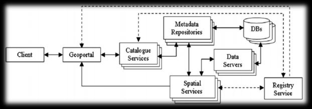
10 7 5 6 Role of UN-GGIM-AP in Disaster Management A Regional Disaster!!! UN-ESC-AP 7 6 National clearinghouse 1 OGC CSW Catalog Server1 Standard ISO Repository1 Database 1 OGC Standards 5 Semantic Translator Semantic descriptio n for goals OGC CSW National geo-portal 5 Catalog Server2 Repository2 Database 2 Emergency planner Regional Geo-portal 6 7 Catalog Server3 Repository3 Database 3 8 Catalog Server1 Repository1 Database 1 Service controller A.I. planning 9 OGC CSW 10 National geo-portal Catalog Server2 Repository2 Database 2 National clearinghouse 2 Catalog Server3 Repository3 Database 3 10
11 Contact information [Name] Ali Javidaneh Technical deputy of NCC [Organization Name] National Cartographic Center, Vice-presidency for strategic planning and supervision, Islamic republic of Iran [ address] 11
National Cartographic Center
 National Cartographic Center NCC activities and accomplishments Activities of national organizations, institutions and universities in field of geomatics Large scale maps Medium scale maps Small scale
NGIAs' roles in successful disaster response
 The Second UN-GGIM-AP Plenary Meeting NGIAs' roles in successful disaster response Japan Teheran Iran 28 October 2013 Shin-ichi SAKABE, Director of International Affairs Division Geospatial Information
Roles of NGII in successful disaster management
 The Second UN-GGIM-AP Plenary Meeting Roles of NGII in successful disaster management Republic of Korea Teheran Iran 28 October 2013 Sanghoon Lee, Ph.D. NGII Outline Type of Disasters Occur in Korea Practical
National Report. 14th General Assembly of the International Cartographic Association. Paris 2011
 National Report 14th General Assembly of the International Cartographic Association Paris 2011 National Cartographic Center P.O.BOX 13185-1684 Azadi Sq. Tehran Iran Tel: +9821 6000031-8 Fax: +9821 6001972
Disaster Management in Republic of Korea
 The Third UN-GGIM-AP Plenary Meeting Disaster Management in Republic of Korea ~Coordination among NGIA & Other Related Organizations and Recommendations~ Bali Indonesia 10 November 2014 Sanghoon Lee, Ph.D.
SDI DEVELOPMENT UPDATES OF INDONESIA
 SDI DEVELOPMENT UPDATES OF INDONESIA DR. ANTONIUS B. WIJANARTO Center For Management And Dissemination Of Geospatial Information GEOSPATIAL INFORMATION AUTHORITY GOVERNMENT OF THE REPUBLIC OF INDONESIA
Report of the Working Group 2 Data Sharing and Integration for Disaster Management *
 UNITED NATIONS E/CONF.104/6 ECONOMIC AND SOCIAL COUNCIL Twentieth United Nations Regional Cartographic Conference for Asia and the Pacific Jeju, 6-9 October 2015 Item 5 of the provisional agenda Report
USING GIS CARTOGRAPHIC MODELING TO ANALYSIS SPATIAL DISTRIBUTION OF LANDSLIDE SENSITIVE AREAS IN YANGMINGSHAN NATIONAL PARK, TAIWAN
 CO-145 USING GIS CARTOGRAPHIC MODELING TO ANALYSIS SPATIAL DISTRIBUTION OF LANDSLIDE SENSITIVE AREAS IN YANGMINGSHAN NATIONAL PARK, TAIWAN DING Y.C. Chinese Culture University., TAIPEI, TAIWAN, PROVINCE
World Meteorological Organization
 World Meteorological Organization Opportunities and Challenges for Development of Weather-based Insurance and Derivatives Markets in Developing Countries By Maryam Golnaraghi, Ph.D. Head of WMO Disaster
Themes for Geomatics Conference. Geodesy Themes
 Themes for Geomatics Conference Geodesy Themes Geodynamics o Modeling the Deformation of the Earth s Crust o Recent Advances in Geometric Approaches to Deformation Analysis o Monitoring Systems (Sensors
The Role Of Ina-SDI For Disaster Management
 The Second UN-GGIM-AP Plenary Meeting The Role Of Ina-SDI For Disaster Management Indonesia Tehran - Iran 28 October 2013 Dodi Sukmayadi Geospatial Information Authority of Indonesia (BIG) COMPONENT FOR
Norwegian spatial data infrastructure supporting disaster risk management Norwegian Mapping Authority
 Norwegian spatial data infrastructure supporting disaster risk management Norwegian Mapping Authority Arvid Lillethun, Norwegian Mapping Authority Land and Poverty 2018 Conference, World Bank 19.-23. March
Challenges and Issues for Regional Geoportal on Disaster Data Sharing - from Perspective of China
 The 3 rd UN-GGIM-AP Plenary Meeting Challenges and Issues for Regional Geoportal on Disaster Data Sharing - from Perspective of China ZHOU Xu, Vice Chair of WG2 National Geomatics Center of China Outline
From PCGIAP to UN GGIM AP: A Regional Perspective on GGIM
 Regional Committee of United Nations Global Geospatial Information Management for Asia and the Pacific (UN-GGIM-AP) Established by a United Nations Resolution From PCGIAP to UN GGIM AP: A Regional Perspective
Georeferencing and Satellite Image Support: Lessons learned, Challenges and Opportunities
 Georeferencing and Satellite Image Support: Lessons learned, Challenges and Opportunities Shirish Ravan shirish.ravan@unoosa.org UN-SPIDER United Nations Office for Outer Space Affairs (UNOOSA) UN-SPIDER
Disaster Management in Mongolia
 The Third UN-GGIM-AP Plenary Meeting Disaster Management in Mongolia ~Coordination among NGIA & Other Related Organizations and Recommendations~ Bali Indonesia 10 November 2014 Khurelshagai Ayurzana, Director
COUNTRY REPORT THE SEVENTEENTH PERMANENT COMMITTEE ON GIS INFRASTRUCTURE FOR ASIA AND THE PACIFIC (PCGIAP) MEETING JULY 21 22, 2011,
 MEETING JULY 21 22, 2011,") COUNTRY REPORT INDONESIA ACTIVITIES IN 2010 THE SEVENTEENTH PERMANENT COMMITTEE ON GIS INFRASTRUCTURE FOR ASIA AND THE PACIFIC (PCGIAP) MEETING JULY 21 22, 2011, CHINGGIS KHAAN HOTEL, ULAANBAATAR CITY,
COUNTRY REPORT INDONESIA ACTIVITIES IN 2010 THE SEVENTEENTH PERMANENT COMMITTEE ON GIS INFRASTRUCTURE FOR ASIA AND THE PACIFIC (PCGIAP) MEETING JULY 21 22, 2011, CHINGGIS KHAAN HOTEL, ULAANBAATAR CITY,
ISLAMIC REPUBLIC OF IRAN NATIONAL REPORT FOR PHOTOGRAMMETRY, REMOTE SENSING AND SPATIAL INFORMATION SCIENCE
 ISLAMIC REPUBLIC OF IRAN NATIONAL REPORT FOR PHOTOGRAMMETRY, REMOTE SENSING AND SPATIAL INFORMATION SCIENCE 2004-2008 A. Eslami Rad a, M. Sarpoulaki b a Director Technical Advisor, National Cartographic
One Map Policy to Support National Development in Indonesia
 One Map Policy to Support National Development in Indonesia Dr. Nurwadjedi Sarbini Deputy of Thematic Geospatial Information Geospatial Information Agency (BIG) Geosmart Asia, September 29 October 1, 2015
WEATHER AND CLIMATE EXTREMES MONITORING BASED ON SATELLITE OBSERVATION : INDONESIA PERSPECTIVE RIRIS ADRIYANTO
 WEATHER AND CLIMATE EXTREMES MONITORING BASED ON SATELLITE OBSERVATION : INDONESIA PERSPECTIVE RIRIS ADRIYANTO INDONESIA AGENCY FOR METEOROLOGY, CLIMATOLOGY AND GEOPHYSICS (BM KG) 1. INTRODUCTION - BMKG
IGOS Geohazards: toward an improved use of Earth Observations for Geohazards mitigation
 IGOS Geohazards: toward an improved use of Earth Observations for Geohazards mitigation Scientific and Technical Subcommittee session Vienna, 15th February 2007 Gonéri Le Cozannet IGOS Geohazards Bureau
Country Report Nepal Geospatial Data Sharing Initiatives of Survey Department Supporting Disaster Management
 Third JPTM Step 2 for Sentinel Asia 6-8 July, 2010 Manila, The Philippines Country Report Nepal Geospatial Data Sharing Initiatives of Survey Department Supporting Disaster Management Durgendra M Kayastha
RS / GIS for Disaster Management. Some Important Definitions. Classifications of Natural Disasters. Disasters W/Some Human Influence
 RS / GIS for Disaster Management A Basic Introduction to Natural Disasters Using Remote Sensing & GIS ~~~~~~~~~~ Rev. Ronald J. Wasowski, C.S.C. Associate Professor of Environmental Science University
Sri Lanka Enhancing the Role of ICTs for Disaster Risk Management
 Workshop on ICT for Promoting Inclusive and Disaster Resilient Development Ulaanbaatar, Mongolia Sri Lanka Enhancing the Role of ICTs for Disaster Risk Management Kanchana Thudugala Programme Head, eservices
The Third UN-GGIM-AP Plenary Meeting. Use of Geospatial Information in Disaster and Coordination among NDMA and Relevant Organizations/Stakeholders
 The Third UN-GGIM-AP Plenary Meeting Use of Geospatial Information in Disaster and Coordination among NDMA and Relevant Organizations/Stakeholders Bali Indonesia 10 November 2014 Bernardus Wisnu Widjaja
Economic and Social Council
 United Nations Economic and Social Council Distr.: General 23 May 2012 Original: English E/CONF.101/100 Tenth United Nations Conference on the Standardization of Geographical Names New York, 31 July 9
Report for 15th PCGIAP Meeting at 18th UNRCC-AP Working Group 1 Regional Geodesy
 Report for 15th PCGIAP Meeting at 18th UNRCC-AP Working Group 1 Regional Geodesy Chairman Shigeru Matsuzaka, Japan - shigeru@gsi.go.jp Vice Chairman Prof. Pengfei Cheng, China - chengpf@casm.ac.cn John
Challenges and Potentials of Place Based Information Management in Nepal"
 Nineteenth United Nations Regional Cartographic Conference for Asia and the Pacific, Bangkok, Thailand, 29 October 1 November 2012 Challenges and Potentials of Place Based Information Management in Nepal"
Country Report on SDI Activities in Singapore *
 UNITED NATIONS E/CONF.100/CRP.9 ECONOMIC AND SOCIAL COUNCIL Eighteenth United Nations Regional Cartographic Conference for Asia and the Pacific Bangkok, 26-29 October 2009 Item 7(a) of the provisional
Country Report On Sdi Activities In Singapore ( )
") UNITED NATIONS E/CONF.102/IP.4 ECONOMIC AND SOCIAL COUNCIL Nineteenth United Nations Regional Cartographic Conference for Asia and the Pacific Bangkok, 29 October 1 November 2012 Item 6(b) of the provisional
UNITED NATIONS E/CONF.102/IP.4 ECONOMIC AND SOCIAL COUNCIL Nineteenth United Nations Regional Cartographic Conference for Asia and the Pacific Bangkok, 29 October 1 November 2012 Item 6(b) of the provisional
Report of PCGIAP to the 18 th United Nations Regional Cartographic Conference for Asia and the Pacific (UNRCC-AP) for the period
 for the period") Permanent Committee on GIS Infrastructure for Asia and the Pacific (PCGIAP) Established in 1995 by a United Nations Resolution Report of PCGIAP to the 18 th United Nations Regional Cartographic Conference
Permanent Committee on GIS Infrastructure for Asia and the Pacific (PCGIAP) Established in 1995 by a United Nations Resolution Report of PCGIAP to the 18 th United Nations Regional Cartographic Conference
Building a National Data Repository
 Building a National Data Repository Mladen Stojic, Vice President - Geospatial 1/30/2013 2012 Intergraph Corporation 1 Information has meaning and gives power only when shared and distributed. Information,
Seismic Activity and Crustal Deformation after the 2011 Off the Pacific Coast of Tohoku Earthquake
 J-RAPID Symposium March 6-7, 2013 Seismic Activity and Crustal Deformation after the 2011 Off the Pacific Coast of Tohoku Earthquake Y. Honkura Tokyo Institute of Technology Japan Science and Technology
Data Quality and Uncertainty. Accuracy, Precision, Data quality and Errors
 Data Quality and Uncertainty The power of GIS analysis is based on the assembly of layers of data, but as data layers increase, errors multiply (and quality decreases). Garbage in, garbage out. High quality
Spanish national plan for land observation: new collaborative production system in Europe
 ADVANCE UNEDITED VERSION UNITED NATIONS E/CONF.103/5/Add.1 Economic and Social Affairs 9 July 2013 Tenth United Nations Regional Cartographic Conference for the Americas New York, 19-23, August 2013 Item
BANGLADESH SURVEY OF BANGLADESH PREMISES
 BANGLADESH SURVEY OF BANGLADESH PREMISES Survey of Bangladesh (SOB) is the National Mapping organization of Bangladesh SOB is carrying out all Geodetic activities of Bangladesh SOB is responsible for taking
Funding models for institutional arrangements in the context of a national SDI: the case of Chile
 Funding models for institutional arrangements in the context of a national SDI: the case of Chile Alvaro Monett Hernández Executive Secretary SNIT Chile Vice-President UN-GGIM Américas Fifth Meeting of
EARTH OBSERVATION SERVICES IN REPUBLIC OF MOLDOVA
 EARTH OBSERVATION SERVICES IN REPUBLIC OF MOLDOVA Vasile ALCAZ 1 Ion APOSTOL 2 1 Institute of Geology and Seismology Moldavian Academy of Sciences 2 Ministry of Environment and Natural Resources Republic
Geo-information and Disaster Risk Reduction in the Hindu Kush-Himalayan region
 Geo-information and Disaster Risk Reduction in the Hindu Kush-Himalayan region Basanta Shrestha, Division Head MENRIS, International Centre for Integrated Mountain Development Kathmandu, Nepal The International
Yrd. Doç. Dr. Saygın ABDİKAN Öğretim Yılı Güz Dönemi
 Yabancı Dil III (YDL285) Introduction to Geomatics Yrd. Doç. Dr. Saygın ABDİKAN 2017-2018 Öğretim Yılı Güz Dönemi 1 géomatique Geo (Earth) + informatics Geodesy + Geoinformatics Geomatics: The mathematics
Crowdsourcing approach for large scale mapping of built-up land
 Crowdsourcing approach for large scale mapping of built-up land Kavinda Gunasekara Kavinda@ait.asia Geoinformatics Center Asian Institute of Technology, Thailand. Regional expert workshop on land accounting
GEOGRAPHY (029) CLASS XI ( ) Part A: Fundamentals of Physical Geography. Map and Diagram 5. Part B India-Physical Environment 35 Marks
 CLASS XI ( ) Part A: Fundamentals of Physical Geography. Map and Diagram 5. Part B India-Physical Environment 35 Marks") GEOGRAPHY (029) CLASS XI (207-8) One Theory Paper 70 Marks 3 Hours Part A Fundamentals of Physical Geography 35 Marks Unit-: Geography as a discipline Unit-3: Landforms Unit-4: Climate Unit-5: Water (Oceans)
GEOGRAPHY (029) CLASS XI (207-8) One Theory Paper 70 Marks 3 Hours Part A Fundamentals of Physical Geography 35 Marks Unit-: Geography as a discipline Unit-3: Landforms Unit-4: Climate Unit-5: Water (Oceans)
EXPLORE PLATE TECTONICS & MORE THROUGH GPS DATA. Shelley Olds, UNAVCO April 12, 2018 NGSS Webinar
 EXPLORE PLATE TECTONICS & MORE THROUGH GPS DATA Shelley Olds, UNAVCO April 12, 2018 NGSS Webinar Today s Outline Central question: How do we know the tectonic plates are still moving? -- What evidence
GEO-VIII November Geohazard Supersites and Natural Laboratories Progress Report. Document 9
 GEO-VIII 16-17 November 2011 Geohazard Supersites and Natural Laboratories Progress Report Document 9 This document is submitted to GEO-VIII for information. Geohazard Supersites and Natural Laboratories
Application of a GIS for Earthquake Hazard Assessment and Risk Mitigation in Vietnam
 Application of a GIS for Earthquake Hazard Assessment and Risk Mitigation in Vietnam Nguyen Hong Phuong Earthquake Information and Tsunami Warning Centre, VAST OUTLINE Introduction Fault Source Model and
International Union of Geodesy and Geophysics. Resolutions
 International Union of Geodesy and Geophysics Resolutions ADOPTED BY THE COUNCIL AT THE XXVI GENERAL ASSEMBLY PRAGUE, CZECH REPUBLIC (22 JUNE 2 JULY 2015) 0 Page Resolution 1: Role of Ocean in Climate
State of Israel Ministry of Housing and Construction Survey of Israel. The Hydrological project case
 State of Israel Ministry of Housing and Construction Survey of Israel The Hydrological project case Survey of Israel Content Introduction To the Survey of Israel The operation assumptions The main responsibilities
Portfolio of karteco Cadastral Survey Department
 Portfolio of karteco Cadastral Survey Department 01-2016 Who we are? karteco Environmental & Energy Engineering Consultancy Founding members: Apostolos Karteris Dr. Environmental Engineer Marinos Karteris
Climatic Extreme Events over Iran: Observation and Future Projection
 3rd Meeting of COMSATS International Thematic Research Group on Climate Change and Environmental Protection (22nd January 2014, Islamabad, Pakistan) Climatic Extreme Events over Iran: Observation and Future
GIS in Weather and Society
 GIS in Weather and Society Olga Wilhelmi Institute for the Study of Society and Environment National Center for Atmospheric Research WAS*IS November 8, 2005 Boulder, Colorado Presentation Outline GIS basic
Assessing Hazards and Risk
 Page 1 of 6 EENS 204 Tulane University Natural Disasters Prof. Stephen A. Nelson Assessing Hazards and Risk This page last updated on 07-Jan-2004 As discussed before, natural disasters are produced by
UNITED NATIONS E/CONF.97/6/IP. 34
 UNITED NATIONS E/CONF.97/6/IP. 34 ECONOMIC AND SOCIAL COUNCIL Seventeenth United Nations Regional Cartographic Conference for Asia and the Pacific Bangkok, 18-22 September 2006 Item 7 of the provisional
Add NOAA nowcoast Layers to Maps
 WebEOC Maps Add-on Quick Reference Guide Add NOAA nowcoast Layers to Maps Overview With Maps Add-on, you can configure an unlimited number of map layers. These layers allow you to control the data you
GEOMATICS. Shaping our world. A company of
 GEOMATICS Shaping our world A company of OUR EXPERTISE Geomatics Geomatics plays a mayor role in hydropower, land and water resources, urban development, transport & mobility, renewable energy, and infrastructure
EARTHQUAKE PROFILE. Figure 1-Seismic hazard map, I.R.Iran
 EARTHQUAKE PROFILE The Iranian plateau has long been known as one of the seismically active areas of the world and it frequently suffers destructive and catastrophic earthquakes that cause heavy loss of
Geospatial Infrastructure that Helps Keep us Resilient to Natural Disasters - Japan s example
 Regional Workshop on Strengthening Multi-Hazard Early Warning System in Pacific Islands Countries Nuku alofa, Tonga 26-27 April 2018 Geospatial Infrastructure that Helps Keep us Resilient to Natural Disasters
GEODETIC NETWORK OF SAUDI ARABIA AND FIDUCIAL STATIONS. GFN OF Saudi Arabia in Based on ITRF2000 Datum
 STUDIES OF TECTONIC MOVEMENTS IN SAUDI ARABIA USING CORS M. Al Rajhi, Ali Al Omar, R. Yanar, F. Kartal, K. Eren, SUBJECT TO TALKS BACKGROUND GEODETIC NETWORK OF SAUDI ARABIA AND FIDUCIAL STATIONS GFN OF
Country Report. KAZAKHSTAN DAN of SENTINEL ASIA INITIATIVE
 Country Report KAZAKHSTAN DAN of SENTINEL ASIA INITIATIVE Putrajaya, 2011 LAND RESOURCES OF KAZAKHSTAN Area 2,72 mln km 2 Population 16 Mln Land use Area Mln. ha % Territory of Republic 272,4 Agriculture
Disaster Risk Reduction in Survey for Seismic Protection of MES
 Survey for Seismic Protection Ministry of Emergency Situations of Republic of Armenia Disaster Risk Reduction in Survey for Seismic Protection of MES Syuzanna Kakoyan Leading specialist at the Department
Status and Challenges on Geo-DRM Information Systems in Tonga
 Name: Mafua- i-vai utukakau Maka Status and Challenges on Geo-DRM Information Systems in Tonga 1 Roles and Relationships Land and Geographic Information Systems (LGIS) Unit: Establish updated high-resolution
RESAP Progress Report
 RESAP Progress Report December 2016 to October 2017 Presentation to the Twenty-first session of the Intergovernmental Consultative Committee on the Regional Space Applications Programme for Sustainable
July 5-6, 2010 Mytilene, Greece
 Web GIS platform for forest fire management Prof. Kostas Kalabokidis Principal Investigator Univ. of the Aegean, Dept. of Geography, Greece Prof. George Kallos Univ. of Athens, Dept. of Physics, Greece
SEISMIC RISK ASSESSMENT IN ARMENIA
 SEISMIC RISK ASSESSMENT IN ARMENIA Hovhannes Khangeldyan Head of National Crisis Management Center Rescue Service Ministry of Emergency Situations of the Republic of Armenia Tokyo, 2016 ARMENIA: GEOGRAPHICAL
GenEd Courses offered by Dept. of Geography, Presidency University
 GenEd Courses offered by Dept. of Geography, Presidency University (All the Courses are offered to both Science and Humanities Students) Semester Course No. Course Name Maximum No. of Students (originally
Land Administration and Cadastre
 Geomatics play a major role in hydropower, land and water resources and other infrastructure projects. Lahmeyer International s (LI) worldwide projects require a wide range of approaches to the integration
Development of the Kingdom of Tonga Cyclone Emergency Recovery and Management System using Geospatial Tools
 Development of the Kingdom of Tonga Cyclone Emergency Recovery and Management System using Geospatial Tools Case Studies from Small Island States FIG Commissions 3, 7 and 8 Malcolm Archbold General Manager
Use of Geospatial data for disaster managements
 Use of Geospatial data for disaster managements Source: http://alertsystemsgroup.com Instructor : Professor Dr. Yuji Murayama Teaching Assistant : Manjula Ranagalage What is GIS? A powerful set of tools
Presented to Sub-regional workshop on integration of administrative data, big data and geospatial information for the compilation of SDG indicators
 Presented to Sub-regional workshop on integration of administrative data, big data and geospatial information for the compilation of SDG indicators 23-25 April,2018 Addis Ababa, Ethiopia By: Deogratius
Operational Aspects of GNSS CORS What is a GNSS CORS system used for?
 Please insert a picture (Insert, Picture, from file). Size according to grey field (10 cm x 25.4 cm). Scale picture: highlight, pull corner point Cut picture: highlight, choose the cutting icon from the
Upgrade the Datasets in NSDI for Smarter Services with the Cases of China
 Upgrade the Datasets in NSDI for Smarter Services with the Cases of China By Dr. JIANG Jie Dept of GeoInformaiton Service Platform National Geomatics Center of China October 7, 2015 Jeju, Republic of Korea
Design of Safety Monitoring and Early Warning System for Buried Pipeline Crossing Fault
 5th International Conference on Civil Engineering and Transportation (ICCET 2015) Design of Safety Monitoring and Early Warning System for Buried Pipeline Crossing Fault Wu Liu1,a, Wanggang Hou1,b *, Wentao
INSPIRATION results and benefits for the Agency for Real Estate Cadastre
 JOINT RESEARCH CENTER - E&I WORKSHOP INSPIRATION results and benefits for the Agency for Real Estate Cadastre Sonja Dimova, state advisor AGENCY FOR REAL ESTATE CADASTRE REPUBLIC OF MACEDONIA Wednesday,
5.2. IDENTIFICATION OF NATURAL HAZARDS OF CONCERN
 5.2. IDENTIFICATION OF NATURAL HAZARDS OF CONCERN To provide a strong foundation for mitigation strategies considered in Sections 6 and 9, County considered a full range of natural hazards that could impact
Progress of Space Technology Application for Disaster Management in China
 Progress of Space Technology Application for Disaster Management in China LI Qun Department of Disaster Relief Ministry of Civil Affairs of P.R.China Background drought 1 2 flood earthquake typhoon Progress
DATA APPLIANCE FOR ARCGIS
 DATA APPLIANCE FOR ARCGIS Data Appliance for ArcGIS Provides Access to Multi-Scale Basemaps Down to Medium Scale Levels Worldwide And Large Scale for Most of the World The Data Appliance includes Several
IDENTIFICATION OF HAZARDS OF CONCERN
 IDENTIFICATION OF HAZARDS OF CONCERN To provide a strong foundation for mitigation strategies considered in Section 6, the Village considered a full range of hazards that could impact the area and then
Progress on GCOS-China CMA IOS Development Plan ( ) PEI, Chong Department of Integrated Observation of CMA 09/25/2017 Hangzhou, China
 PEI, Chong Department of Integrated Observation of CMA 09/25/2017 Hangzhou, China") Progress on GCOS-China CMA IOS Development Plan (2016-2020) PEI, Chong Department of Integrated Observation of CMA 09/25/2017 Hangzhou, China 1. Progress on GCOS-China 1 Organized GCOS-China GCOS-China
Progress on GCOS-China CMA IOS Development Plan (2016-2020) PEI, Chong Department of Integrated Observation of CMA 09/25/2017 Hangzhou, China 1. Progress on GCOS-China 1 Organized GCOS-China GCOS-China
J M MIRANDA UNIVERSITY OF LISBON THE USE OF REMOTE SENSING FOR EARTHQUAKE RISK ASSESSMENT AND MITIGATION
 1 THE USE OF REMOTE SENSING FOR EARTHQUAKE RISK ASSESSMENT AND MITIGATION 2 the observation of strong ground motion and aftershock sequences as well as the investigation of the destruction from these earthquakes
GEO Geohazards Community of Practice
 GEO Geohazards Community of Practice 1) Co-Chair of GHCP With input from: Stuart Marsh, GHCP Co-Chair Francesco Gaetani, GEO Secretariat and many GHCP contributors 1) Nevada Bureau of Mines and Geology
Canadian Geo Course Introduction
 Canadian Geo 1202 Course Introduction Course Overview Unit 1 Natural and Human Systems (SCO 1.0 and SCO 2.0) - What happens when systems interact? In this unit students are challenged to reflect on the
Current Status of the Standardization of Geographical Names in Cambodia
 1 Current Status of the Standardization of Geographical Names in Cambodia His Excellency Ith Sotha, Under Secretary of States, MLMUPC Mr Chharom Chin, Deputy Director, Geography Department, MLMUPC Mr Narith
AND THE COOPERATION WITH SENTINEL ASIA FOR DISASTER MANAGEMENT
 Ministry of Natural resources and Environment National Remote Sensing DEpartment NATIONAL REMOTE SENSING DEPARTMENT (NRSD) AND THE COOPERATION WITH SENTINEL ASIA FOR DISASTER MANAGEMENT By: Dr. Chu Hai
March 2007 The Survey Department of Sri Lanka
 Contribution of Survey Department of Sri Lanka for Mitigation of Disasters in Sri Lanka K.A.U.N.Kasthuri Deputy Surveyor General (Information Technology) March 2007 The Survey Department of Sri Lanka 1
Plan4all (econtentplus project)
") Plan4all (econtentplus project) Karel CHARVAT 1, Tomáš MILDORF 2 1 Help service remote sensing, Ltd., Černoleská 1600, 256 01 Benešov u Prahy, Czech Republic charvat@bnhelp.cz 2 Department of Mathematics
Plan4all (econtentplus project) Karel CHARVAT 1, Tomáš MILDORF 2 1 Help service remote sensing, Ltd., Černoleská 1600, 256 01 Benešov u Prahy, Czech Republic charvat@bnhelp.cz 2 Department of Mathematics
INDONESIA S S UPDATE: GEOSPATIAL INFORMATION FOR SUSTAINABLE DEVELOPMENT RELATED TO INA SDI Dr. Asep Karsidi, M.Sc
 INDONESIA S S UPDATE: GEOSPATIAL INFORMATION FOR SUSTAINABLE DEVELOPMENT RELATED TO INA SDI Dr. Asep Karsidi, M.Sc GEOSPATIAL INFORMATION AGENCY 08 August, 2012 OUTLINE 1. Transformation Bakosurtanal into
HISTORY OF HEAVY RAINFALL DISASTER INFORMATION IN JAPAN
 transmission, for a state-of-the-art review. In addition, issues expected to arise in the future are discussed. HISTORY OF HEAVY RAINFALL DISASTER INFORMATION IN JAPAN Progress of Rainfall Observation
Urban Planning for Tehran, By Using Environmental Modeling and GIS/RS
 Urban Planning for Tehran, By Using Environmental Modeling and GIS/RS Alireza GHARAGOZLU, Iran Key words: GIS, Environmental Planning, Remote Sensing, modeling, development SUMMARY The environment is a
Copernicus Overview. Major Emergency Management Conference Athlone 2017
 Copernicus Overview Major Emergency Management Conference Athlone 2017 Copernicus is a European programme implemented by the European Commission. The services address six thematic areas: land, marine,
A Broad View of Geospatial Technology & Systems
 A Broad View of Geospatial Technology & Systems Pete Large Vice President, Trimble On the shoulders of giants 1 Since their time, our ability to generate geospatial information has grown exponentially
Geography General Course Year 12. Selected Unit 3 syllabus content for the. Externally set task 2019
 Geography General Course Year 12 Selected Unit 3 syllabus content for the Externally set task 2019 This document is an extract from the Geography General Course Year 12 syllabus, featuring all of the content
Building Institutional Capacity for Multi-Hazard Early Warning in Asia and the Pacific Subtitle
 Building Institutional Capacity for Multi-Hazard Early Warning in Asia and the Pacific Subtitle Title Keran Wang Chief, Space Applications Section ICT and Disaster Risk Reduction Division 22 May 2018 Pillar
Guidelines for Site-Specific Seismic Hazard Reports for Essential and Hazardous Facilities and Major and Special-Occupancy Structures in Oregon
 Guidelines for Site-Specific Seismic Hazard Reports for Essential and Hazardous Facilities and Major and Special-Occupancy Structures in Oregon By the Oregon Board of Geologist Examiners and the Oregon
Building Institutional Capacity for Multi-Hazard Early Warning in Pacific Countries Subtitle
 Building Institutional Capacity for Multi-Hazard Early Warning in Pacific Countries Subtitle Title Keran Wang Chief, Space Applications Section ICT and Disaster Risk Reduction Division 30 March 2018 Slide
Mainstream Space Technology in Implementing SFDRR - GPSTAR. Srimal Samansiri Disaster Management Centre Government of Sri Lanka
 Mainstream Space Technology in Implementing SFDRR - GPSTAR Srimal Samansiri Disaster Management Centre Government of Sri Lanka SFDRR Priority Actions Effective use of Space technology in SFDRR Priority
Brazil Paper for the. Second Preparatory Meeting of the Proposed United Nations Committee of Experts on Global Geographic Information Management
 Brazil Paper for the Second Preparatory Meeting of the Proposed United Nations Committee of Experts on Global Geographic Information Management on Data Integration Introduction The quick development of
Landslide monitoring system in Iceland. Harpa Grímsdóttir Jón Kristinn Helgason NVE, Oslo, October
 Landslide monitoring system in Iceland Harpa Grímsdóttir Jón Kristinn Helgason NVE, Oslo, October 26 2016 History Avalanches and landslides have caused extensive damages and loss of human lives in Iceland
ADVANTAGES OF GIS-INTEGRATED MARITIME DATA IN THE BLACK SEA REGION FOR MULTIPURPOSE USE
 INTERAGENCY INTERACTION IN CRISIS MANAGEMENT AND DISASTER RESPONSE 2017 ADVANTAGES OF GIS-INTEGRATED MARITIME DATA IN THE BLACK SEA REGION FOR MULTIPURPOSE USE Lyubka Pashova 1, Anna Kortcheva 2, Vasko
Strategic Framework on Geospatial Information and Services for Disasters Relevance for the Americas Region
 Strategic Framework on Geospatial Information and Services for Disasters Relevance for the Americas Region Seventh Session of the Committee of Experts on UN-GGIM Side Event --- UN Headquarters, New York
Pre-eruptive ground deformation of Azerbaijan mud volcanoes detected through satellite radar interferometry (DInSAR)
") Pre-eruptive ground deformation of Azerbaijan mud volcanoes detected through satellite radar interferometry (DInSAR) Tectonophysics 637 (2014) 163 177 Speaker:Yi-Huei,Cho Advisor :Loung-Yie,Tsai Date:2016/12/08
Pre-eruptive ground deformation of Azerbaijan mud volcanoes detected through satellite radar interferometry (DInSAR) Tectonophysics 637 (2014) 163 177 Speaker:Yi-Huei,Cho Advisor :Loung-Yie,Tsai Date:2016/12/08
Republic of Mozambique
 Republic of Mozambique Second Expert's Symposium on Multi-Hazard Early Warning Systems with focus on the Role of National Meteorological and Hydrological Services 5-7 May 2009, Toulouse France 1. Background