July 5-6, 2010 Mytilene, Greece
|
|
|
- Adele Henderson
- 5 years ago
- Views:
Transcription

1 Web GIS platform for forest fire management Prof. Kostas Kalabokidis Principal Investigator Univ. of the Aegean, Dept. of Geography, Greece Prof. George Kallos Univ. of Athens, Dept. of Physics, Greece Research Group: Dr. C. Vasilakos Dr. N. Athanasis P. Palaiologou J. Dimou G. Hiotellis G. Aggelopoulou M. Kyrou Dr. G. Galanis Dr. C. Mitsakou C. Spyrou N. Hatzopoulos Virtual Fire Final Review & PR Event Microsoft Research Microsoft, Redmond, USA Microsoft Hellas Microsoft Innovation Center, Greece
2 Objective of the research: new Web GIS application of Microsoft Bing TM Maps aimed to assist on early fire warning, fire control, and GPS navigation and coordination of firefighting forces 2 / 52
3 Identity of the research Virtual Fire (VF) is a research projectrun run by University of the Aegean, and supported by University of Athens and Microsoft Hellas/MIC in Greece; and funded by Microsoft Research. VF is a fully stand-alone, alone, web-based based early warning and decision support system for integrated forest fire management, based on geo-informatics and IT modeling. The main concept of the project is that firefighting forces need a tool to easily, validly, promptly and immediately access geographical and relational data during a fire event, without the knowledge of handling complicated GIS applications and the installation of special desktop software. End-users will be able to access 3-day weather forecasting maps, daily fire risk maps, real-time fire behavior maps, vehicle and resource positions, high-resolution satellite images etc., all through a simple Internet connection of their portable computer or GPS with the VF platform. 3 / 52


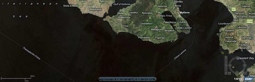
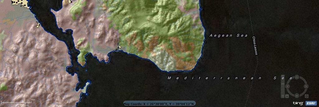
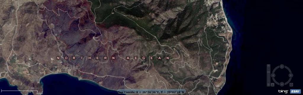
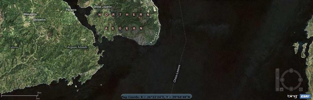
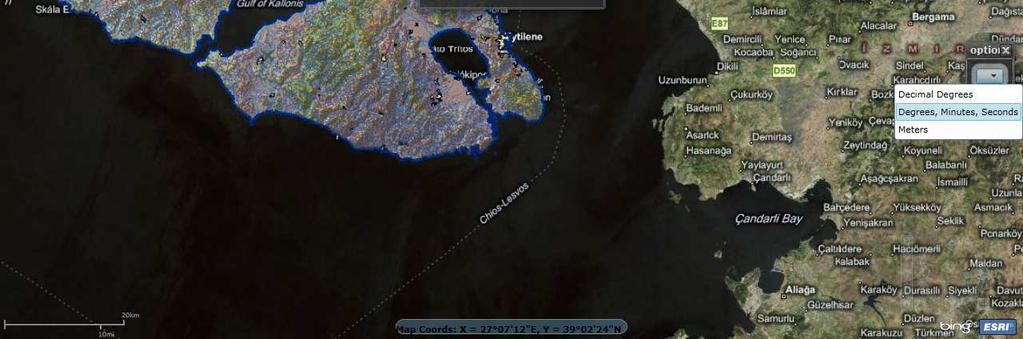
4 Pilot case study: Lesvos Island, Greece w/ an area of 1,636 km 2 & 90,000 residents, located at northeastern Aegean Sea ECOSYSTEMS & FOREST FIRES OF LESVOS ISLAND Map Legend Fire-prone and high-risk area of Greece: more than 600 wildfires, mostly human-caused, occurred between resulting in about 9,000 hectares of total area burned 4 / 52
5 Design of services offered to forest fire and civil protection agencies through the VF management system: 1. Remote automatic weather stations and a weather forecasting system provide all the necessary fire meteorology info for fire prevention, early warning, and control 2. Geographical representation of the fire risk potential and identification of high-risk areas at different local regions are provided on-demand, based on meteorological, socio-economic, and biophysical parameters 3. Maps that represent the spread and intensity of a forest fire at different times and places; thus, authorities will have the ability to design an operational plan to encompass the forest fire, choosing the best way to put out the fire with the proper means at the proper time 4. On-line and real-time location of Fire Service vehicles and other resources by using GPS and communications that transmit the coordinates of each item to the system, portraying them on an electronic map/ video wall; thus, achieving better coordination in emergency response & resource dispatching 5. In-situ situdetection cameras along with prompt satellite images are of added value as integrated extensions to the VF platform 6. State-of-the-art know-how and advanced computing schemes; e.g. spatial modeling, GIS and remote sensing, specialized software and algorithms, and high performance computing (HPC). 5 / 52
6 Technical contents of the research GSM/GPRS PROTOCOLS FOR DATA SUBMISSION & RECEPTION INPUT OF DATA INTO GPS SQL QUERIES: SPATIAL & RELATIONAL SATELLITE IMAGES OF HIGH RESOLUTION THEMATIC MAPPING FIRE RISK AND BEHAVIOR PREDICTION VISUALIZATION VIA MS BING MAPS AND MS SILVERLIGHT 3 LIVE COVERAGE OF EVENTS (VIDEOS FROM CAMERAS AND DATA FROM WEATHER STATIONS) FLEET TRACKING MANAGEMENT 6 / 52

 is the primary mapping information platform, and all data and maps are displayed as overlays on top of it.")
7 Technologies and platforms employed Virtual Fire is based on ESRI ArcGIScommercial commercial software: maps and functions are created within this software in close integration with MS SQL Server 2008; ; outcomes are published to the web via the ArcGIS Server; MS Visual Studio 2008combines them all with MS Silverlight 3by using components of ArcGIS APIfor MS Silverlight / WPF. MS Bing Maps(ex Virtual Earth) is the primary mapping information platform, and all data and maps are displayed as overlays on top of it. The integration of the above plus the addition of other components from external sites comprise the VF software architecture. 7 / 52
8 Other technologies and platforms employed Use of ESRI ArcSDE geo-databases to store geographic and other data (compliant with MS SQL Server 2008) Use of SKIRONweather prediction HPC models (University of Athens) to create weather forecasting maps FARSITEand Flammapfire growth and behavior simulation models to predict fire behavior Neural networks for fire risk mapping (Windows HPC Server 2008compliant software developed by the project) GPRS / GSM protocols for data transmission. 8 / 52
9 Overall Project Achievements 1. Ability to select among the Bing Maps database and several other layers (high- resolution satellite images, ortho-photos, thematic maps, topographic maps) 2. GeoRSS live data streams for new fire events, with ability to add new events 3. Ability to monitor and survey several weather forecasting maps (temperature, relative humidity, cloud cover, rain and wind), with a prediction range of 3 days and update once every day (09:00 am local time) 4. Access to data of 5 Remote Automatic Weather Stations (RAWS) with real-time diagrams and weather monitor graphics 5. Ability to access several different fire/ disaster management data (road network, water tanks, evacuations areas, etc.), and switch among them at will 6. Daily fire risk maps that portray the potential of fire occurrence, based on a high performance computing (HPC) pilot application with Microsoft Windows HPC server 7. On-demand fire behavior modeling 8. A rich toolbox with mapping and other tools that enhance interoperability (shortest routes, closest water tanks, service areas, measurement and digitizing tools, s, fleet tracking, web-cameras, etc.) 9. Daily updated world satellite imagery courtesy of NASA/GSFC/JPL-Caltech, Caltech, OnEarth, MODIS Terra (WMS map); and other live feeds of worldwide disasters 10. GPS navigation and data collection utility with Windows Mobile Operating System. 9 / 52

10 BING MAPS 10 / 52
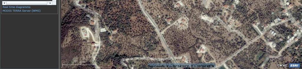
11 HIGH-RESOLUTION SATELLITE IMAGES 11 / 52

12 BASE MAP SELECTION 12 / 52
13 Overall Project Achievements 1. Ability to select among the Bing Maps database and several other layers (high- resolution satellite images, ortho-photos, thematic maps, topographic maps) 2. GeoRSS live data streams for new fire events, with ability to add new events 13 / 52

14 GEO-RSS WEB FEEDS 14 / 52
15 Overall Project Achievements 1. Ability to select among the Bing Maps database and several other layers (high- resolution satellite images, ortho-photos, thematic maps, topographic maps) 2. GeoRSS live data streams for new fire events, with ability to add new events 3. Ability to monitor and survey several weather forecasting maps (temperature, relative humidity, cloud cover, rain and wind), with a prediction range of 3 days and update once every day (09:00 am local time) 15 / 52
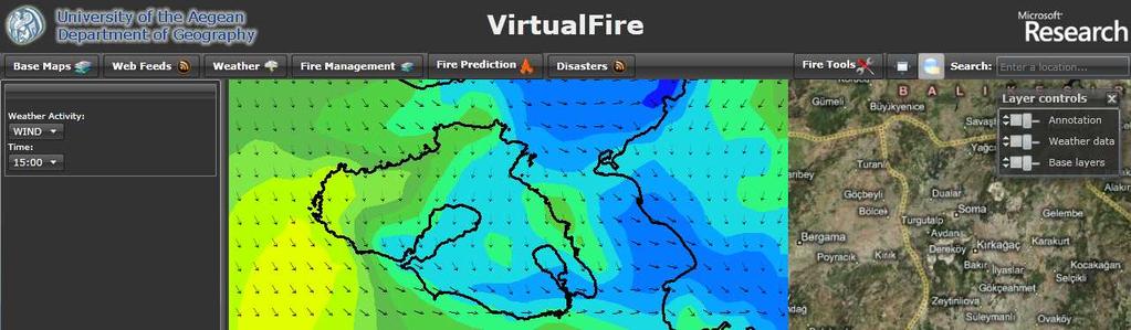
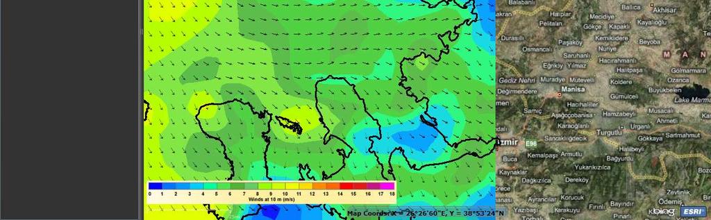
16 WEATHER PREDICTION MAPS 16 / 52
17 Overall Project Achievements 1. Ability to select among the Bing Maps database and several other layers (high- resolution satellite images, ortho-photos, thematic maps, topographic maps) 2. GeoRSS live data streams for new fire events, with ability to add new events 3. Ability to monitor and survey several weather forecasting maps (temperature, relative humidity, cloud cover, rain and wind), with a prediction range of 3 days and update once every day (09:00 am local time) 4. Access to data of 5 Remote Automatic Weather Stations (RAWS) with real-time diagrams and weather monitor graphics 17 / 52

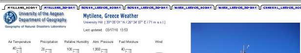
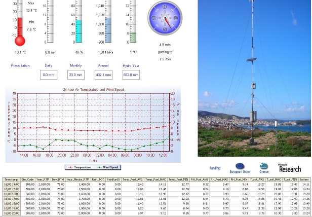
18 ONLINE WEATHER MONITORING 18 / 52
19 Overall Project Achievements 1. Ability to select among the Bing Maps database and several other layers (high- resolution satellite images, ortho-photos, thematic maps, topographic maps) 2. GeoRSS live data streams for new fire events, with ability to add new events 3. Ability to monitor and survey several weather forecasting maps (temperature, relative humidity, cloud cover, rain and wind), with a prediction range of 3 days and update once every day (09:00 am local time) 4. Access to data of 5 Remote Automatic Weather Stations (RAWS) with real-time diagrams and weather monitor graphics 5. Ability to access several different fire/ disaster management data (road network, water tanks, evacuations areas, etc.), and switch among them at will 19 / 52
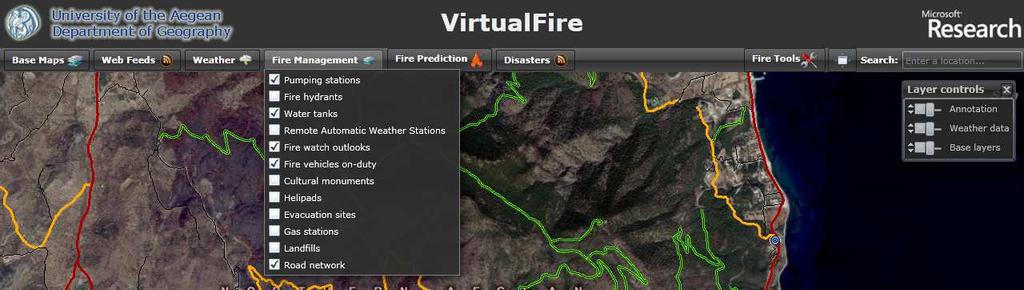
20 FIRE MANAGEMENT DATA 20 / 52
21 Overall Project Achievements 1. Ability to select among the Bing Maps database and several other layers (high- resolution satellite images, ortho-photos, thematic maps, topographic maps) 2. GeoRSS live data streams for new fire events, with ability to add new events 3. Ability to monitor and survey several weather forecasting maps (temperature, relative humidity, cloud cover, rain and wind), with a prediction range of 3 days and update once every day (09:00 am local time) 4. Access to data of 5 Remote Automatic Weather Stations (RAWS) with real-time diagrams and weather monitor graphics 5. Ability to access several different fire/ disaster management data (road network, water tanks, evacuations areas, etc.), and switch among them at will 6. Daily fire risk maps that portray the potential of fire occurrence, based on a high performance computing (HPC) pilot application with Microsoft Windows HPC server 21 / 52

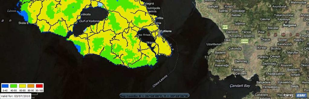
22 FIRE RISK MAPPING 22 / 52
23 Fire Risk Mapping w/ Microsoft Windows HPC Server implementation of parallel computing / HPC in geospatial problems large geographical extent & spatial resolution need increased computing power the thread model approach from sequential to parallel utilized computation speed increase of about 33% (with 2 computing nodes, 8 cores total) processing avg. time: sequential = 333 sec vs. HPC = 224 sec easy to be implemented from a non IT end-user fast network required, i.e. Infiniband expensive third party components need to be installed in every computing node 23 / 52
24 Overall Project Achievements 1. Ability to select among the Bing Maps database and several other layers (high- resolution satellite images, ortho-photos, thematic maps, topographic maps) 2. GeoRSS live data streams for new fire events, with ability to add new events 3. Ability to monitor and survey several weather forecasting maps (temperature, relative humidity, cloud cover, rain and wind), with a prediction range of 3 days and update once every day (09:00 am local time) 4. Access to data of 5 Remote Automatic Weather Stations (RAWS) with real-time diagrams and weather monitor graphics 5. Ability to access several different fire/ disaster management data (road network, water tanks, evacuations areas, etc.), and switch among them at will 6. Daily fire risk maps that portray the potential of fire occurrence, based on a high performance computing (HPC) pilot application with Microsoft Windows HPC server 7. On-demand fire behavior modeling 24 / 52


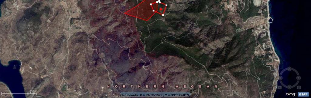
25 FIRE BEHAVIOR MODELING 25 / 52


26 FIRE BEHAVIOR MODELING All the necessary land cover data for the creation of a permanent ready-to-launch fire prediction application were inventoried and analyzed; and cover / fuel types were mapped using geo-statistics and GIS techniques. 26 / 52
27 Overall Project Achievements 1. Ability to select among the Bing Maps database and several other layers (high- resolution satellite images, ortho-photos, thematic maps, topographic maps) 2. GeoRSS live data streams for new fire events, with ability to add new events 3. Ability to monitor and survey several weather forecasting maps (temperature, relative humidity, cloud cover, rain and wind), with a prediction range of 3 days and update once every day (09:00 am local time) 4. Access to data of 5 Remote Automatic Weather Stations (RAWS) with real-time diagrams and weather monitor graphics 5. Ability to access several different fire/ disaster management data (road network, water tanks, evacuations areas, etc.), and switch among them at will 6. Daily fire risk maps that portray the potential of fire occurrence, based on a high performance computing (HPC) pilot application with Microsoft Windows HPC server 7. On-demand fire behavior modeling 8. A rich toolbox with mapping and other tools that enhance interoperability (shortest routes, closest water tanks, service areas, measurement and digitizing tools, s, fleet tracking, web-cameras, etc.) 27 / 52

28 FIRE MAP TOOLS 28 / 52

29 SKETCH TOOLS 29 / 52
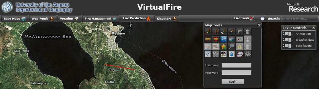
30 DISTANCE MEASUREMENTS 30 / 52

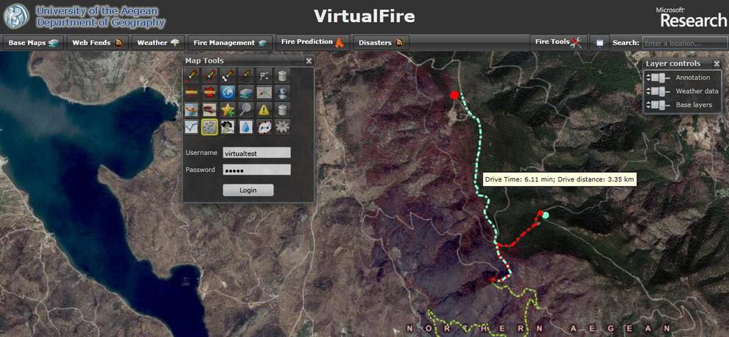
31 DRIVE TIMES 31 / 52


32 FIND CLOSEST WATER TANKS 32 / 52


33 FIND CLOSEST PUMPING STATIONS 33 / 52


34 FIND CLOSEST HYDRANTS 34 / 52


35 FIND SHORTEST ROUTES 35 / 52

36 FORMAT CHANGE OF COORDINATES 36 / 52


37 ADDITION OF NEW FIRE EVENTS 37 / 52


38 REMOVAL OF OLD FIRE EVENTS 38 / 52


39 S FROM END-USERS 39 / 52


40 REAL-TIME TRACKING OF FIRE SERVICE VEHICLES 40 / 52


41 REAL-TIME TRACKING OF FIRE PATROL & SUPPRESSION AIRCRAFTS 41 / 52


42 LIVE CAMERA IMAGES 42 / 52
43 Overall Project Achievements 1. Ability to select among the Bing Maps database and several other layers (high- resolution satellite images, ortho-photos, thematic maps, topographic maps) 2. GeoRSS live data streams for new fire events, with ability to add new events 3. Ability to monitor and survey several weather forecasting maps (temperature, relative humidity, cloud cover, rain and wind), with a prediction range of 3 days and update once every day (09:00 am local time) 4. Access to data of 5 Remote Automatic Weather Stations (RAWS) with real-time diagrams and weather monitor graphics 5. Ability to access several different fire/ disaster management data (road network, water tanks, evacuations areas, etc.), and switch among them at will 6. Daily fire risk maps that portray the potential of fire occurrence, based on a high performance computing (HPC) pilot application with Microsoft Windows HPC server 7. On-demand fire behavior modeling 8. A rich toolbox with mapping and other tools that enhance interoperability (shortest routes, closest water tanks, service areas, measurement and digitizing tools, s, fleet tracking, web-cameras, etc.) 9. Daily updated world satellite imagery courtesy of NASA/GSFC/JPL-Caltech, Caltech, OnEarth, MODIS Terra (WMS map); and other live feeds of worldwide disasters 43 / 52


44 MODIS TERRA SATELLITE IMAGES (Daily Planet) 44 / 52

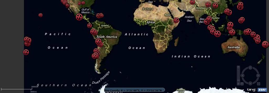
45 Live Feeds: Earthquakes (USGS) 45 / 52


46 Live Feeds: Fire Hot Spots (MODIS) 46 / 52


47 Live Feeds: Hurricane Tracks (NWS) 47 / 52


48 Live Feeds: River Gauges (NWS) 48 / 52
49 Overall Project Achievements 1. Ability to select among the Bing Maps database and several other layers (high- resolution satellite images, ortho-photos, thematic maps, topographic maps) 2. GeoRSS live data streams for new fire events with ability to add new events 3. Ability to monitor and survey several weather forecasting maps (temperature, relative humidity, cloud cover, rain and wind), with a prediction range of 3 days and update once every day (09:00 am local time) 4. Access to data of 5 Remote Automatic Weather Stations (RAWS) with real-time diagrams and weather monitor graphics 5. Ability to access several different fire/ disaster management data (road network, water tanks, evacuations areas, etc.), and switch among them at will 6. Daily fire risk maps that portray the potential of fire occurrence, based on a high performance computing (HPC) pilot application with Microsoft Windows HPC server 7. On-demand fire behavior modeling 8. A rich toolbox with mapping and other tools that enhance interoperability (shortest routes, closest water tanks, service areas, measurement and digitizing tools, s, fleet tracking, web-cameras, etc.) 9. Daily updated world satellite imagery courtesy of NASA/GSFC/JPL-Caltech, Caltech, OnEarth, MODIS Terra (WMS map); and other live feeds of worldwide disasters 10. GPS navigation and data collection utility with Windows Mobile Operating System. 49 / 52

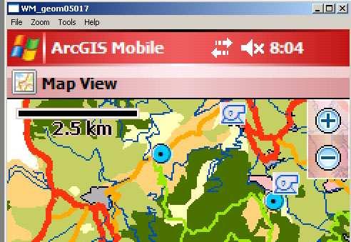
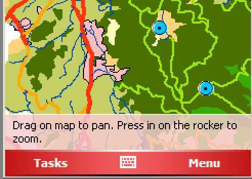
50 MOBILE GPS DATA NAVIGATION & MAPPING UTILITY 50 / 52

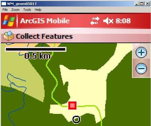
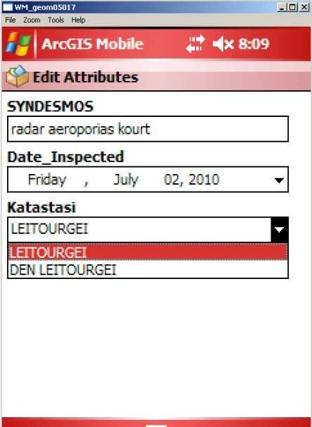


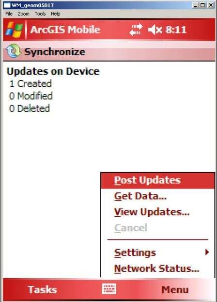
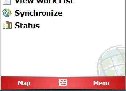
51 MOBILE GPS DATA COLLECTION UTILITY 51 / 52

52 Questions?
Geometric Algorithms in GIS
 Geometric Algorithms in GIS GIS Visualization Software Dr. M. Gavrilova GIS Software for Visualization ArcView GEO/SQL Digital Atmosphere AutoDesk Visual_Data GeoMedia GeoExpress CAVE? Visualization in
EuroGEOSS Protected Areas Pilot
 EuroGEOSS Protected Areas Pilot Max Craglia European Commission Joint Research Centre Part 1: the present MyNatura2000 Mobile app. Awareness raising & volunteered data collection. Natura2000 covers 18%
Chapter 10: The Future of GIS Why Speculate? 10.2 Future Data 10.3 Future Hardware 10.4 Future Software 10.5 Some Future Issues and Problems
 Chapter 10: The Future of GIS 10.1 Why Speculate? 10.2 Future Data 10.3 Future Hardware 10.4 Future Software 10.5 Some Future Issues and Problems Theme of the Course GIS's place in understanding geographic
The Emerging Role of Enterprise GIS in State Forest Agencies
 The Emerging Role of Enterprise GIS in State Forest Agencies Geographic Information System (GIS) A geographic information system (GIS) is a computer software system designed to capture, store, manipulate,
These modules are covered with a brief information and practical in ArcGIS Software and open source software also like QGIS, ILWIS.
 Online GIS Training and training modules covered are: 1. ArcGIS, Analysis, Fundamentals and Implementation 2. ArcGIS Web Data Sharing 3. ArcGIS for Desktop 4. ArcGIS for Server These modules are covered
Working with ArcGIS Online
 Esri International User Conference San Diego, CA Technical Workshops July 12, 2011 Working with ArcGIS Online Bern Szukalski, Deane Kensok Topics for this Session ArcGIS Online Overview ArcGIS Online Content
ESRI Survey Summit August Clint Brown Director of ESRI Software Products
 ESRI Survey Summit August 2006 Clint Brown Director of ESRI Software Products Cadastral Fabric How does Cadastral fit with Survey? Surveyors process raw field observations Survey measurements define high-order
GIS Workshop Data Collection Techniques
 GIS Workshop Data Collection Techniques NOFNEC Conference 2016 Presented by: Matawa First Nations Management Jennifer Duncan and Charlene Wagenaar, Geomatics Technicians, Four Rivers Department QA #: FRG
GIS CONCEPTS Part I. GIS ON THE WEB Part II
 Week 2 GIS CONCEPTS Part I GIS ON THE WEB Part II topics of the week part I GIS functions and GIS data Spatial relationships Organizing convention for spatial data Store Information by thematic layers
Geospatial Fire Behavior Modeling App to Manage Wildfire Risk Online. Kenyatta BaRaKa Jackson US Forest Service - Consultant
 Geospatial Fire Behavior Modeling App to Manage Wildfire Risk Online Kenyatta BaRaKa Jackson US Forest Service - Consultant Fire Behavior Modeling and Forest Fuel Management Modeling Fire Behavior is an
GIS in Weather and Society
 GIS in Weather and Society Olga Wilhelmi Institute for the Study of Society and Environment National Center for Atmospheric Research WAS*IS November 8, 2005 Boulder, Colorado Presentation Outline GIS basic
Applications of GIS in Electrical Power System
 Applications of GIS in Electrical Power System Abdulrahman M. AL-Sakkaf 201102310 CRP 514 May 2013 Dr. Baqer M. AL-Ramadan Abstract GIS has been widely used in various areas and disciplines. This paper
Features and Benefits
 Autodesk LandXplorer Features and Benefits Use the Autodesk LandXplorer software family to help improve decision making, lower costs, view and share changes, and avoid the expense of creating physical
ArcGIS. for Server. Understanding our World
 ArcGIS for Server Understanding our World ArcGIS for Server Create, Distribute, and Manage GIS Services You can use ArcGIS for Server to create services from your mapping and geographic information system
Introduction to Geographic Information Systems (GIS): Environmental Science Focus
: Environmental Science Focus") Introduction to Geographic Information Systems (GIS): Environmental Science Focus September 9, 2013 We will begin at 9:10 AM. Login info: Username:!cnrguest Password: gocal_bears Instructor: Domain: CAMPUS
Introduction to Geographic Information Systems (GIS): Environmental Science Focus September 9, 2013 We will begin at 9:10 AM. Login info: Username:!cnrguest Password: gocal_bears Instructor: Domain: CAMPUS
GIS = Geographic Information Systems;
 What is GIS GIS = Geographic Information Systems; What Information are we talking about? Information about anything that has a place (e.g. locations of features, address of people) on Earth s surface,
GEOGRAPHIC INFORMATION SYSTEMS Session 8
 GEOGRAPHIC INFORMATION SYSTEMS Session 8 Introduction Geography underpins all activities associated with a census Census geography is essential to plan and manage fieldwork as well as to report results
Geo-information and Disaster Risk Reduction in the Hindu Kush-Himalayan region
 Geo-information and Disaster Risk Reduction in the Hindu Kush-Himalayan region Basanta Shrestha, Division Head MENRIS, International Centre for Integrated Mountain Development Kathmandu, Nepal The International
EBA Engineering Consultants Ltd. Creating and Delivering Better Solutions
 EBA Engineering Consultants Ltd. Creating and Delivering Better Solutions ENHANCING THE CAPABILITY OF ECOSYSTEM MAPPING TO SUPPORT ADAPTIVE FOREST MANAGEMENT Prepared by: EBA ENGINEERING CONSULTANTS LTD.
e-pathai GIS (Electronic Project, Administration, Traffic, Highway Assets and Information management system) in Tamil Nadu Highways
 in Tamil Nadu Highways") e-pathai GIS (Electronic Project, Administration, Traffic, Highway Assets and Information management system) in Tamil Nadu Highways Er.G.Kumar¹, Er.R.Sendel Raj², Er.P.Eshwarmoorthy³, Dr.P.Rajakumar 4
e-pathai GIS (Electronic Project, Administration, Traffic, Highway Assets and Information management system) in Tamil Nadu Highways Er.G.Kumar¹, Er.R.Sendel Raj², Er.P.Eshwarmoorthy³, Dr.P.Rajakumar 4
Enabling ENVI. ArcGIS for Server
 Enabling ENVI throughh ArcGIS for Server 1 Imagery: A Unique and Valuable Source of Data Imagery is not just a base map, but a layer of rich information that can address problems faced by GIS users. >
Imagery and the Location-enabled Platform in State and Local Government
 Imagery and the Location-enabled Platform in State and Local Government Fred Limp, Director, CAST Jim Farley, Vice President, Leica Geosystems Oracle Spatial Users Group Denver, March 10, 2005 TM TM Discussion
Corporate. Information. Railway Infrastructure Administrator. Year indracompany.com
 geospatial and mobility Corporate Geographic Information System of ADIF Railway Infrastructure Administrator. Year 2009-2010 Corporate Geographic Information System of ADIF ADIF. Spanish Administrator
Great Lakes Information Network GIS (Queryable by topic, geography, organization, and upload date 73 layers as of October, 2009)
") Google Earth Files for the Great Lakes and Beyond GLOS Mapping Workshop Alpena, Michigan November 9, 2009 David Hart GIS Specialist University of Wisconsin Sea Grant Institute GREAT LAKES Great Lakes Information
Google Earth Files for the Great Lakes and Beyond GLOS Mapping Workshop Alpena, Michigan November 9, 2009 David Hart GIS Specialist University of Wisconsin Sea Grant Institute GREAT LAKES Great Lakes Information
FUNDAMENTALS OF GEOINFORMATICS PART-II (CLASS: FYBSc SEM- II)
") FUNDAMENTALS OF GEOINFORMATICS PART-II (CLASS: FYBSc SEM- II) UNIT:-I: INTRODUCTION TO GIS 1.1.Definition, Potential of GIS, Concept of Space and Time 1.2.Components of GIS, Evolution/Origin and Objectives
FUNDAMENTALS OF GEOINFORMATICS PART-II (CLASS: FYBSc SEM- II) UNIT:-I: INTRODUCTION TO GIS 1.1.Definition, Potential of GIS, Concept of Space and Time 1.2.Components of GIS, Evolution/Origin and Objectives
EO Information Services. Assessing Vulnerability in the metropolitan area of Rio de Janeiro (Floods & Landslides) Project
 Project") EO Information Services in support of Assessing Vulnerability in the metropolitan area of Rio de Janeiro (Floods & Landslides) Project Ricardo Armas, Critical Software SA Haris Kontoes, ISARS NOA World
EO Information Services in support of Assessing Vulnerability in the metropolitan area of Rio de Janeiro (Floods & Landslides) Project Ricardo Armas, Critical Software SA Haris Kontoes, ISARS NOA World
Techniques for Science Teachers: Using GIS in Science Classrooms.
 Techniques for Science Teachers: Using GIS in Science Classrooms. After ESRI, 2008 GIS A Geographic Information System A collection of computer hardware, software, and geographic data used together for
Cutting Edge Engineering for Modern Geospatial Systems Rear Admiral Dr. S Kulshrestha, retd
 Cutting Edge Engineering for Modern Geospatial Systems Rear Admiral Dr. S Kulshrestha, retd 11 Jun 2015 GeoIntelligence Asia 2015 The technology would become so pervasive that it becomes a part of you
LAYMAN S REPORT Floods and Fire Risk Assessment and Management
 LAYMAN S REPORT Floods and Fire Risk Assessment and Management FLIRE is 50% co-financed by LIFE + financial instrument of the European Union. Floods and Fire risk assessment and management Project s code
SOLUTIONS ADVANCED GIS. TekMindz are developing innovative solutions that integrate geographic information with niche business applications.
 ADVANCED GIS SOLUTIONS TekMindz are developing innovative solutions that integrate geographic information with niche business applications. TEK INDZ TM GIS Services Overview At the leading edge of geospatial
Geography for the 2020 Round of Census
 Boundaries Key Census Data EA Id Population Male Female EA Id Area EA Id Num HH Avg HH size Geography for the 2020 Round of Census Linda Peters, Esri lpeters@esri.com Integration of Statistical and Geospatial
Introduction to ArcGIS Server - Creating and Using GIS Services. Mark Ho Instructor Washington, DC
 Introduction to ArcGIS Server - Creating and Using GIS Services Mark Ho Instructor Washington, DC Technical Workshop Road Map Product overview Building server applications GIS services Developer Help resources
Available online at Analele Stiintifice ale Universitatii Al. I. Cuza din Iasi Seria Geologie 58 (1) (2012) 53 58
 (2012) 53 58") Available online at http://geology.uaic.ro/auig/ Analele Stiintifice ale Universitatii Al. I. Cuza din Iasi Seria Geologie 58 (1) (2012) 53 58 AUI GEOLOGIE GIS database for mineral resources: case study
Available online at http://geology.uaic.ro/auig/ Analele Stiintifice ale Universitatii Al. I. Cuza din Iasi Seria Geologie 58 (1) (2012) 53 58 AUI GEOLOGIE GIS database for mineral resources: case study
Crime Analyst Extension. Christine Charles
 Crime Analyst Extension Christine Charles ccharles@esricanada.com Agenda Why use Crime Analyst? Overview Tools Demo Interoperability With our old software it could take a police officer up to forty minutes
a system for input, storage, manipulation, and output of geographic information. GIS combines software with hardware,
 Introduction to GIS Dr. Pranjit Kr. Sarma Assistant Professor Department of Geography Mangaldi College Mobile: +91 94357 04398 What is a GIS a system for input, storage, manipulation, and output of geographic
Massachusetts Institute of Technology Department of Urban Studies and Planning
 Massachusetts Institute of Technology Department of Urban Studies and Planning 11.520: A Workshop on Geographic Information Systems 11.188: Urban Planning and Social Science Laboratory GIS Principles &
NR402 GIS Applications in Natural Resources
 NR402 GIS Applications in Natural Resources Lesson 1 Introduction to GIS Eva Strand, University of Idaho Map of the Pacific Northwest from http://www.or.blm.gov/gis/ Welcome to NR402 GIS Applications in
Introduction to GIS. Geol 4048 Geological Applications of Remote Sensing
 Introduction to GIS Geol 4048 Geological Applications of Remote Sensing GIS History: Before Computers GIS History Using maps for a long time Dr. Roger F. Tomlinson Father of GIS He was an English geographer
A Technique for Importing Shapefile to Mobile Device in a Distributed System Environment.
 A Technique for Importing Shapefile to Mobile Device in a Distributed System Environment. 1 Manish Srivastava, 2 Atul Verma, 3 Kanika Gupta 1 Academy of Business Engineering and Sciences,Ghaziabad, 201001,India
Crisis Management and Natural Disasters Overview of JRC operational or pre-operational activities A. Annunziato, D. Al-Khudhairy
 Papagayo, Costarica 3-4 November 2009 Security Science and The Americas 1 Joint Research Centre (JRC) Crisis Management and Natural Disasters Overview of JRC operational or pre-operational activities A.
FIRE DEPARMENT SANTA CLARA COUNTY
 DEFINITION FIRE DEPARMENT SANTA CLARA COUNTY GEOGRAPHIC INFORMATION SYSTEM (GIS) ANALYST Under the direction of the Information Technology Officer, the GIS Analyst provides geo-spatial strategic planning,
GIS. in the City of Lewiston Maine
 GIS in the City of Lewiston Maine The purpose of this slideshow is to provide an overview of the city GIS and how it is used, maintained and accessed in-house as well as by the public. Please simply hit
Why GIS & Why Internet GIS?
 Why GIS & Why Internet GIS? The Internet bandwagon Internet mapping (e.g., MapQuest) Location-based services Real-time navigation (e.g., traffic) Real-time service dispatch Business Intelligence Spatial
Challenges and Issues for Regional Geoportal on Disaster Data Sharing - from Perspective of China
 The 3 rd UN-GGIM-AP Plenary Meeting Challenges and Issues for Regional Geoportal on Disaster Data Sharing - from Perspective of China ZHOU Xu, Vice Chair of WG2 National Geomatics Center of China Outline
Geospatial SDI Portal for effective Governance of Pune METROPOLIS region
 Geospatial SDI Portal for effective Governance of Pune METROPOLIS region Mr. Praveen Gautam Senior Manager 19 th January 2018 PMRDA Overview Provide a Spatial Framework for the entire region with various
Floodplain Mapping & Flood Warning Applications in North Carolina
 Floodplain Mapping & Flood Warning Applications in North Carolina Marc Stanard, IT Project Manager Ken Ashe, Assistant Director David Herlong, Flood Warning Program Manager NC Crime Control & Public Safety
SRJC Applied Technology 54A Introduction to GIS
 SRJC Applied Technology 54A Introduction to GIS Overview Lecture of Geographic Information Systems Fall 2004 Santa Rosa Junior College Presented By: Tim Pudoff, GIS Coordinator, County of Sonoma, Information
Google Maps and Beyond
 Google Maps and Beyond Aaron Paul First American Title apaul@firstam.com 2015 APRA Symposium Association of Professional Reserve Analysts May 2 nd, 2015 Google Maps and Beyond - Overview Business case
You are Building Your Organization s Geographic Knowledge
 You are Building Your Organization s Geographic Knowledge And Increasingly Making it Available Sharing Data Publishing Maps and Geo-Apps Developing Collaborative Approaches Citizens Knowledge Workers Analysts
Applications: Introduction Task 1: Introduction to ArcCatalog Task 2: Introduction to ArcMap Challenge Question References
 CHAPTER 1 INTRODUCTION 1.1 GIS? 1.1.1 Components of a GIS 1.1.2 A Brief History of GIS 1.1.3 GIS Software Products Box 1.1 A List of GIS Software Producers and Their Main Products 1.2 GIS Applications
Smart Data Collection and Real-time Digital Cartography
 Smart Data Collection and Real-time Digital Cartography Yuji Murayama and Ko Ko Lwin Division of Spatial Information Science Faculty of Life and Environmental Sciences University of Tsukuba IGU 2013 1
Watershed Application of WEPP and Geospatial Interfaces. Dennis C. Flanagan
 Watershed Application of WEPP and Geospatial Interfaces Dennis C. Flanagan Research Agricultural Engineer USDA-Agricultural Research Service Adjunct Professor Purdue Univ., Dept. of Agric. & Biol. Eng.
June 19 Huntsville, Alabama 1
 June 19 Huntsville, Alabama 1 Real-Time Geospatial Data: The Fusion of PI and ArcGIS Enabling Smarter Facilities Management OSIsoft and Esri Mapping and Location Analytics Platform Supporting Your Use
Personal Field Data Collection by UM-FieldGIS (Integration of Google Map API to Mobile GIS)
") Personal Field Data Collection by UM-FieldGIS (Integration of Google Map API to Mobile GIS) Ko Ko Lwin*. Yuji MURAYAMA* *Division of Spatial Information Science Graduate School of Life and Environmental
Personal Field Data Collection by UM-FieldGIS (Integration of Google Map API to Mobile GIS) Ko Ko Lwin*. Yuji MURAYAMA* *Division of Spatial Information Science Graduate School of Life and Environmental
Discovery and Access of Geospatial Resources using the Geoportal Extension. Marten Hogeweg Geoportal Extension Product Manager
 Discovery and Access of Geospatial Resources using the Geoportal Extension Marten Hogeweg Geoportal Extension Product Manager DISCOVERY AND ACCESS USING THE GEOPORTAL EXTENSION Geospatial Data Is Very
Test Bank Chapter 2: Representations of Earth
 Multiple Choice Test Bank Chapter 2: Representations of Earth 1. A rhumb line on a Mercator projection is a line of. a. true size b. true shape c. true compass bearing d. true location 2. Maximum longitude
1. Omit Human and Physical Geography electives (6 credits) 2. Add GEOG 677:Internet GIS (3 credits) 3. Add 3 credits to GEOG 797: Final Project
 2. Add GEOG 677:Internet GIS (3 credits) 3. Add 3 credits to GEOG 797: Final Project") The Department of Geography and the Office of Professional Studies propose to modify the Master of Professional Studies in Geospatial Information Sciences (GIS) as follows: 1. Omit Human and Physical Geography
The Department of Geography and the Office of Professional Studies propose to modify the Master of Professional Studies in Geospatial Information Sciences (GIS) as follows: 1. Omit Human and Physical Geography
HIGH RESOLUTION BASE MAP: A CASE STUDY OF JNTUH-HYDERABAD CAMPUS
 HIGH RESOLUTION BASE MAP: A CASE STUDY OF JNTUH-HYDERABAD CAMPUS K.Manjula Vani, Abhinay Reddy, J. Venkatesh, Ballu Harish and R.S. Dwivedi ABSTRACT The proposed work High Resolution Base map: A Case study
Copernicus Overview. Major Emergency Management Conference Athlone 2017
 Copernicus Overview Major Emergency Management Conference Athlone 2017 Copernicus is a European programme implemented by the European Commission. The services address six thematic areas: land, marine,
State-of-the-Art GIS as an Integrating Technology
 Paper # 104: GIS for Oil Spill Prevention & Response Devon Humphrey Instructor, National Spill Control School Texas A&M University at Corpus Christi, TX Introduction and History The National Spill Control
A Broad View of Geospatial Technology & Systems
 A Broad View of Geospatial Technology & Systems Pete Large Vice President, Trimble On the shoulders of giants 1 Since their time, our ability to generate geospatial information has grown exponentially
ArcGIS for Desktop. ArcGIS for Desktop is the primary authoring tool for the ArcGIS platform.
 ArcGIS for Desktop ArcGIS for Desktop ArcGIS for Desktop is the primary authoring tool for the ArcGIS platform. Beyond showing your data as points on a map, ArcGIS for Desktop gives you the power to manage
Bentley Map Advancing GIS for the World s Infrastructure
 Bentley Map Advancing GIS for the World s Infrastructure Presentation Overview Why would you need Bentley Map? What is Bentley Map? Where is Bentley Map Used? Red text signifies new things in Bentley Map
GI Technology for Disaster Management
 GI Technology for Disaster Management 17 th ICC on the Regional Space Applications Programme for Sustainable Development (RESAP) 26 th Nov 2013 Bangkok Thailand Period and time of seasonal in thailand
HURRICANE MATTHEW A GIS PERSPECTIVE GLYNN COUNTY GIS
 HURRICANE MATTHEW A GIS PERSPECTIVE GLYNN COUNTY GIS Situation September 25 th October 9 th 2016 Hurricane Matthew tracked its way up the east coast bringing hurricane force winds and flooding from Haiti
Better Topographic Map Production Using ArcGIS. A Comprehensive Solution for Mapping Organizations
 Better Topographic Map Production Using ArcGIS A Comprehensive Solution for Mapping Organizations The World Is Always Changing As a member of a national mapping organization, you know this is true. You
4. GIS Implementation of the TxDOT Hydrology Extensions
 4. GIS Implementation of the TxDOT Hydrology Extensions A Geographic Information System (GIS) is a computer-assisted system for the capture, storage, retrieval, analysis and display of spatial data. It
Instituto de Pesquisas Meteorológicas - IPMet Universidade Estadual Paulista - Unesp
 IPMET WEB GIS APPLICATION FOR SEVERE WEATHER ALERT AND DECISION SUPPORT Jaqueline Murakami Kokitsu Instituto de Pesquisas Meteorológicas - IPMet Universidade Estadual Paulista - Unesp IPMet/Unesp Meteorological
Introduction-Overview. Why use a GIS? What can a GIS do? Spatial (coordinate) data model Relational (tabular) data model
 data model Relational (tabular) data model") Introduction-Overview Why use a GIS? What can a GIS do? How does a GIS work? GIS definitions Spatial (coordinate) data model Relational (tabular) data model intro_gis.ppt 1 Why use a GIS? An extension
Introduction-Overview Why use a GIS? What can a GIS do? How does a GIS work? GIS definitions Spatial (coordinate) data model Relational (tabular) data model intro_gis.ppt 1 Why use a GIS? An extension
Applications of GIS in Electrical Power System. Dr. Baqer AL-Ramadan Abdulrahman Al-Sakkaf
 Applications of GIS in Electrical Power System Dr. Baqer AL-Ramadan Abdulrahman Al-Sakkaf OUTLINES: Objective Importance of GIS GIS data development Application of GIS Findings Conclusions and Recommendations
Evaluating e-government : implementing GIS services in Municipality
 Evaluating e-government : implementing GIS services in Municipality Municipality of Thessaloniki - G.I.S. Unit Misirloglou Symeon Head of the GIS Unit ESRI UC - 2016 The GIS Section - subset of the department
ArcGIS is Advancing. Both Contributing and Integrating many new Innovations. IoT. Smart Mapping. Smart Devices Advanced Analytics
 ArcGIS is Advancing IoT Smart Devices Advanced Analytics Smart Mapping Real-Time Faster Computing Web Services Crowdsourcing Sensor Networks Both Contributing and Integrating many new Innovations ArcGIS
Use of Geospatial data for disaster managements
 Use of Geospatial data for disaster managements Source: http://alertsystemsgroup.com Instructor : Professor Dr. Yuji Murayama Teaching Assistant : Manjula Ranagalage What is GIS? A powerful set of tools
5A.10 A GEOSPATIAL DATABASE AND CLIMATOLOGY OF SEVERE WEATHER DATA
 5A.10 A GEOSPATIAL DATABASE AND CLIMATOLOGY OF SEVERE WEATHER DATA Steve Ansari * and Stephen Del Greco NOAA National Climatic Data Center, Asheville, North Carolina Mark Phillips University of North Carolina
Algorithms for GIS csci3225
 Algorithms for GIS csci3225 Laura Toma Bowdoin College Spatial analysis: the beginnings Finding: nb. cholera deaths aer spatially clustered around the Broad St pump 1848, London, John Snow Claim: Cholera
Identifying Audit, Evidence Methodology and Audit Design Matrix (ADM)
") 11 Identifying Audit, Evidence Methodology and Audit Design Matrix (ADM) 27/10/2012 Exercise XXX 2 LEARNING OBJECTIVES At the end of this session participants will be able to: 1. Identify types and sources
11 Identifying Audit, Evidence Methodology and Audit Design Matrix (ADM) 27/10/2012 Exercise XXX 2 LEARNING OBJECTIVES At the end of this session participants will be able to: 1. Identify types and sources
8/28/2011. Contents. Lecture 1: Introduction to GIS. Dr. Bo Wu Learning Outcomes. Map A Geographic Language.
 Contents Lecture 1: Introduction to GIS Dr. Bo Wu lsbowu@polyu.edu.hk Department of Land Surveying & Geo-Informatics The Hong Kong Polytechnic University 1. Learning outcomes 2. GIS definition 3. GIS examples
Integrated Geodatabase Model for effective planning of District -Hamirpur
 Integrated Geodatabase Model for effective planning of District -Hamirpur Developed by District Administration,Hamirpur in collaboration with Centre for Geoinformatics Research and Training, CSK HPAU,Palampur
13.2 USING VIRTUAL GLOBES TO IMPROVE SITUATIONAL AWARENESS IN THE NATIONAL WEATHER SERVICE
 13.2 USING VIRTUAL GLOBES TO IMPROVE SITUATIONAL AWARENESS IN THE NATIONAL WEATHER SERVICE Andy Foster* National Weather Service Springfield, Missouri* Keith Stellman National Weather Service Shreveport,
A Vision for ArcGIS Applying Geography Everywhere
 A Vision for ArcGIS Applying Geography Everywhere WELCOME PURPOSE A Network of GIS Professionals Are Awakening the World to the Power of Web GIS You Your WORK Making a Difference Your Work Open Maps and
STEREO ANALYST FOR ERDAS IMAGINE Stereo Feature Collection for the GIS Professional
 STEREO ANALYST FOR ERDAS IMAGINE Stereo Feature Collection for the GIS Professional STEREO ANALYST FOR ERDAS IMAGINE Has Your GIS Gone Flat? Hexagon Geospatial takes three-dimensional geographic imaging
What is the Living Atlas for ArcGIS and How Can you be Involved?
 Federal GIS Conference February 9 10, 2015 Washington, DC What is the Living Atlas for ArcGIS and How Can you be Involved? Clint Brown Deane Kensok Agenda Introduction to Living Atlas - Transformation
IMPLEMENTING GOVERNMENT-WIDE ENTERPRISE GIS; THE FEDERATED MODEL
 IMPLEMENTING GOVERNMENT-WIDE ENTERPRISE GIS; THE FEDERATED MODEL James E. Mitchell, Ph. D. IT GIS Manager Louisiana Department of Transportation and Development presented at the ESRI International Users
Positioning the Pacific: NOAA s Geospatial Activities. Juliana Blackwell, Director NOAA s National Geodetic Survey March 6, 2012
 Positioning the Pacific: NOAA s Geospatial Activities Juliana Blackwell, Director NOAA s National Geodetic Survey March 6, 2012 A Common Problem of the Early 19 th Century 1807 President Thomas Jefferson
Write a report (6-7 pages, double space) on some examples of Internet Applications. You can choose only ONE of the following application areas:
 on some examples of Internet Applications. You can choose only ONE of the following application areas:") UPR 6905 Internet GIS Homework 1 Yong Hong Guo September 9, 2008 Write a report (6-7 pages, double space) on some examples of Internet Applications. You can choose only ONE of the following application
UPR 6905 Internet GIS Homework 1 Yong Hong Guo September 9, 2008 Write a report (6-7 pages, double space) on some examples of Internet Applications. You can choose only ONE of the following application
CLIMATE CHANGE ADAPTATION BY MEANS OF PUBLIC PRIVATE PARTNERSHIP TO ESTABLISH EARLY WARNING SYSTEM
 CLIMATE CHANGE ADAPTATION BY MEANS OF PUBLIC PRIVATE PARTNERSHIP TO ESTABLISH EARLY WARNING SYSTEM By: Dr Mamadou Lamine BAH, National Director Direction Nationale de la Meteorologie (DNM), Guinea President,
GIS and Remote Sensing
 Spring School Land use and the vulnerability of socio-ecosystems to climate change: remote sensing and modelling techniques GIS and Remote Sensing Katerina Tzavella Project Researcher PhD candidate Technology
Enhance Security, Safety and Efficiency With Geospatial Visualization
 Areas within 10 minutes of an exit are emphasized on this map, to give an indication of how accessible neighborhoods are by highway. The colors represent 1, 3, 5 and 10 minute increments from the exits.
Geo Business Gis In The Digital Organization
 We have made it easy for you to find a PDF Ebooks without any digging. And by having access to our ebooks online or by storing it on your computer, you have convenient answers with geo business gis in
How does ArcGIS Server integrate into an Enterprise Environment? Willy Lynch Mining Industry Specialist ESRI, Denver, Colorado USA
 How does ArcGIS Server integrate into an Enterprise Environment? Willy Lynch Mining Industry Specialist ESRI, Denver, Colorado USA wlynch@esri.com ArcGIS Server Technology Transfer 1 Agenda Who is ESRI?
CS 350 A Computing Perspective on GIS
 CS 350 A Computing Perspective on GIS What is GIS? Definitions A powerful set of tools for collecting, storing, retrieving at will, transforming and displaying spatial data from the real world (Burrough,
Sustainability Adaptation Transparency Accountability. $400 FBC of fuel.
 Sustainability Adaptation Transparency Accountability $400 FBC of fuel. We need a sustainability platform Tools for organization, collaboration, policy, data collection, storage, analysis, understanding,
Building a National Data Repository
 Building a National Data Repository Mladen Stojic, Vice President - Geospatial 1/30/2013 2012 Intergraph Corporation 1 Information has meaning and gives power only when shared and distributed. Information,
Spanish national plan for land observation: new collaborative production system in Europe
 ADVANCE UNEDITED VERSION UNITED NATIONS E/CONF.103/5/Add.1 Economic and Social Affairs 9 July 2013 Tenth United Nations Regional Cartographic Conference for the Americas New York, 19-23, August 2013 Item
Estonian approach to implementation of INSPIRE directive. Sulev Õitspuu Head of Bureau of Geoinfosystems Estonian Land Board
 Estonian approach to implementation of INSPIRE directive Sulev Õitspuu Head of Bureau of Geoinfosystems Estonian Land Board 13.06.2016 Contents - INSPIRE coordination in Estonia - INSPIRE implementation
GIS Integration to Maximo
 GIS Integration to Maximo Tuesday 15 th January 2008 Mahmoud Jaafar Systems Director GISTEC Agenda Introduction Why AMS & GIS Integration? ESRI GIS Enabling Technology. Integrating GIS & Maximo. What do
Introduction to Geographic Information Systems
 Introduction to Geographic Information Systems What is GIS? GIScience, Geography and Cartography GIS Maps Why is it important? What is Driving GIS? Applications of GIS Case Studies Components of a GIS
Development of Webbased. Tool for Tennessee
 Development of Webbased Farm Mapping Tool for Tennessee Southern Region Water Quality Conference, Oct. 24 2005 Forbes Walker and Alan Jolly Biosystems Engineering and SOIL SCIENCE Nutrient Management Planning
CLICK HERE TO KNOW MORE
 CLICK HERE TO KNOW MORE Geoinformatics Applications in Land Resources Management G.P. Obi Reddy National Bureau of Soil Survey & Land Use Planning Indian Council of Agricultural Research Amravati Road,
POSITION DESCRIPTION. Position Title: Geographic Information Systems (GIS) Coordinator Department: Engineering
 Coordinator Department: Engineering") POSITION DESCRIPTION Position Title: Geographic Information Systems (GIS) Coordinator Department: Engineering Reports To: Engineering Supervisor FLSA Status: Exempt Date: April 2018 PRIMARY OBJECTIVE OF
POSITION DESCRIPTION Position Title: Geographic Information Systems (GIS) Coordinator Department: Engineering Reports To: Engineering Supervisor FLSA Status: Exempt Date: April 2018 PRIMARY OBJECTIVE OF