Geospatial Infrastructure that Helps Keep us Resilient to Natural Disasters - Japan s example
|
|
|
- Edwin Griffith
- 5 years ago
- Views:
Transcription
1 Regional Workshop on Strengthening Multi-Hazard Early Warning System in Pacific Islands Countries Nuku alofa, Tonga April 2018 Geospatial Infrastructure that Helps Keep us Resilient to Natural Disasters - Japan s example Ministry of Land, Infrastructure, Transport and Tourism Geospatial Information Authority of Japan Shoichi Oki Geospatial Information Authority of Japan(GSI), Ministry of Land, Infrastructure, Transport and Tourism


2 Geospatial Information Authority of Japan Government Organization and Responsible for Surveying and Mapping in Japan Designated Government Organization in Disaster Management System 2
3 Contents 1. What is UN-GGIM-AP? 2. Hazards in Japan and its geological setting 3. How works ST/GIS for disaster management? (a) Prepare thematic maps to raise awareness (b) Monitoring & Early warning system (c) Quickly find the impact and damages 4. Summary 3
4 Contents 1. What is UN-GGIM-AP? 2. Hazards in Japan and its geological setting 3. How works ST/GIS for disaster management? (a) Prepare thematic maps to raise awareness (b) Monitoring & Early warning system (c) Quickly find the impact and damages 4. Summary 4
5 UN-GGIM-AP: Introduction and Role UN-GGIM-AP Regional Committee of UN-GGIM. Established :1 November 2012 Member: National Geospatial Information Authorities of 56 countries and regions in Asia and the Pacific Current Chair: Dr. Hiroshi Murakami (Japan) Current Secretariat: China Vital Role in (Relevant to geospatial information management) Resolves regional issues Facilitate regional capacity building Promote globally the unique needs and interests of the region Contribute to the discussions in UN-GGIM UN-GGIM (at the Global level) UN-GGIM-AP Technical and substantive activities at the regional level Organize WGs Take Actions/Projects Capacity Building Regional Issues Check Activities Activity Report to UN-GGIM
6 UN-GGIM-AP: Working Group on DRM WG2: Disaster Risk Management Chair: Mr. Toru Nagayama (Japan) This WG aims to enhance the capability of NGIAs in Asia and the Pacific region for contributing to disaster risk reduction by applying geospatial information for effective implementation of Sendai Framework for Disaster Risk Reduction (SFDRR). (*) NGIAs: National Geospatial Information Authorities WG2 of UN-GGIM-AP is discussing specific activities in AP and developing the Guidelines for Disaster Risk Reduction using Geospatial Information to realize the strategic framework adopted by UN-GGIM. Objectives of the Guidelines: To propose practical approaches, efforts, and ideas to help NGIAs in the Asia-Pacific region to strengthen their capabilities in disaster risk reduction. To enhance disaster risk reduction efforts of NGIAs through the Guidelines and by utilizing geospatial information thereby contributing to the implementation of SFDRR in the Asia-Pacific region.
7 Contents 1. What is UN-GGIM-AP? 2. Hazards in Japan and its geological setting 3. How works ST/GIS for disaster management? (a) Prepare thematic maps to raise awareness (b) Monitoring & Early warning system (c) Quickly find the impact and damages 4. Summary 7


8 Seismicity Map of the World Earthquakes > M5.0 in Japan Ring of fire Earthquake Research Institute, University of Tokyo, 8

9 Active Volcanoes in Japan Active Volcanoes : 110 Constant Monitoring : 50 Ref. Japan Meteorological agency


10 Tectonic Plates around Japan Eurasian plate North American plate Pacific plate Philippine Sea plate Ref. NIED Drag in tsunami Rebound


11 Hazards in Japan Earthquake Tsunami Volcanic Eruption Tropical Storm Flood Landslide Great Hanshin-Awaji Earthquake in 1995 Hiroshima city debris flow disaster in 1999 Great East Japan Earthquake in 2011 Mt. Ontake eruption in 2014 Kochi prefecture heavy rain disaster in 1998
12 World Risk Index (UNU, 2016) 世界リスク指標 脅威への晒され易さ 脆弱性 被害の受け易さ 社会の対応力の欠如 社会の長期的対応力の欠如 17. JAPAN 出典 :World Risk Report 2016 (UNU) 12
13 Contents 1. What is UN-GGIM-AP? 2. Hazards in Japan and its geological setting 3. How works ST/GIS for disaster management? (a) Prepare thematic maps to raise awareness (b) Monitoring & Early warning system (c) Quickly find the impact and damages 4. Summary 13
14 Contents 1. What is UN-GGIM-AP? 2. Hazards in Japan and its geological setting 3. How works ST/GIS for disaster management? (a) Prepare thematic maps to raise awareness (b) Monitoring & Early warning system (c) Quickly find the impact and damages 4. Summary 14

15 Active Fault Map Disaster Risk Reduction


16 Geospatial Information for Individuals < 0.5m m m m m > 6.0m Maximum Depth of Water in Case of Predicted Tsunami Tsunami hazard map


17 Volcano Land Condition Map

18 Land Condition Map for Flood Risk

19 Hazard Map for Landslide


")
20 Hazard Maps prepared by Local Municipalities Flood Hazard Map Inland Waters Hazard Map Landslide Disaster Hazard Map Ota-Ku, Tokyo Height Tide Hazard Map Minato-Ku, Tokyo Map of the supposed inundation area Utsunomiya City, Tochigi Prefecture Tsunami Hazard Map Shimonoseki City, Yamaguchi Prefecture Volcano Hazard Map Osaka Bay Earthquake Damage Estimation Map Kochi City, Kochi Prefecture Ground Subsidence(Liquefaction) Map Mount Tarumae (Hokkaido) Mishima City, Shizuoka Prefecture Nishio City, Aichi Prefecture


")

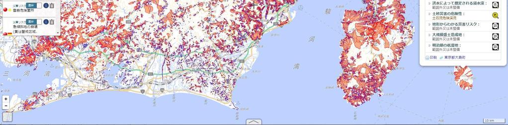
21 MLIT Hazard Map Portal Site Information useful for evacuation and disaster preparedness Overlaid hazard maps Various information about anywhere in Japan, which is useful for disaster risk reduction, can be overlaid and viewed as a single map. road information Overlaying information and viewing as one map Local hazard maps Hazard maps of municipalities across Japan are available. landslide-prone areas estimated flooded areas photo Flood hazard map (Chiyoda Ward, Tokyo) Tsunami hazard map (Fujisawa City) Evacuation route Measures for flooding Enhancing seismic safety Measures for liquefaction Hazard Map Portal Site : ハザードマップ 検索
22 Contents 1. What is UN-GGIM-AP? 2. Hazards in Japan and its geological setting 3. How works ST/GIS for disaster management? (a) Prepare thematic maps to raise awareness (b) Monitoring & Early warning system (c) Quickly find the impact and damages 4. Summary 22
23 Strategy of Early warning Speed of Radio wave/electric signal >> Primary Seismic wave > Secondary Seismic wave = Crustal deformation > Tsunami wave Use this time delay! 23


24 Early warning using seismic sensor on the ground JMA JMA


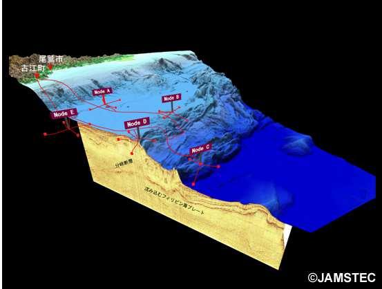
25 Seismic and Tsunami sensor on the sea floor


26 Sea floor network systems for earthquakes and tsunamis SNET 150points Cable length=5700 km DONET1 22 points DONET2 29 points
 GNSS: Global Navigation")
 QZSS(Japan) CORS North")


27 GNSS Continuously Operating Reference Stations (CORS) GNSS: Global Navigation Satellite System Galileo(EU) GLONASS(Russia) QZSS(Japan) CORS North American plate GPS(US) Receiver Eurasian plate GNSS antenna IP Router UPS Batteries Pacific plate 5-m high stainless pillar Tilt meter Heater Arrester Philippine Sea plate The CORS network has 1318 stations over the whole country (at ~20 km interval). The continuous GNSS observation enables accurate measurement of crustal deformation. Minami Tori island
28 Crustal Deformation Caused by the Great East Japan Earthquake in 2011 Video showing the crustal deformation caused by the Great East Japan Earthquake. GNSS CORS detects co-seismic crustal deformation caused by earthquakes. Large SE-ward displacement (max. 5.3m) was observed during the Great East Japan Earthquake.
29 Crustal deformation detected by GNSS CORS the deformation caused by the Great East Japan Earthquake 1 meter


30 REGARD system workflow Real-time CORS Network for Tsunami Warning 30
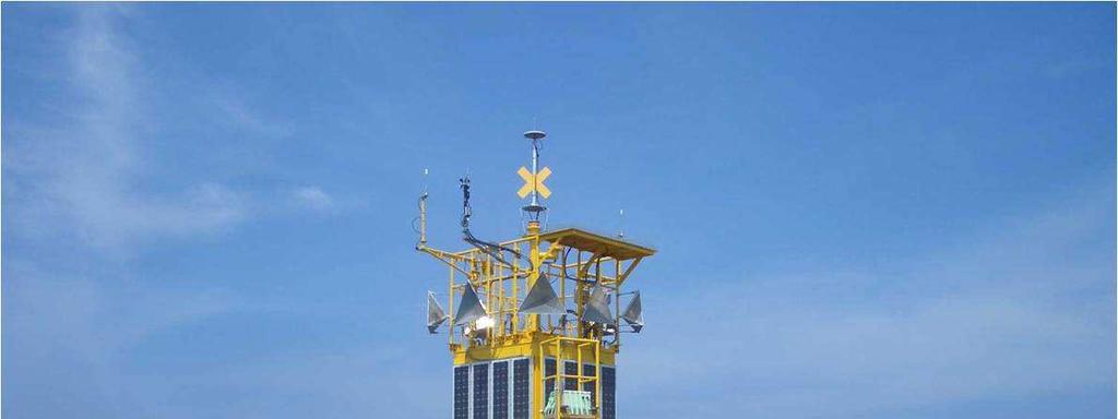


31 GPS Comprehensive Oceanographic Monitoring System

32 NOWPHAS : Nationwide Ocean Wave information network for Ports and HArbourS Current status Future Plan using communication satellite


33 Earthquake Early Warning System All data from various sensors are send to JMA (Japan Metrological Agency) for Warning using TV/mobile devices etc.


34 Monitor volcano using SAR satellite -Mount Kirishima- JAXA

35 InSAR Method phase 2nd Pass First Pass Raise Up


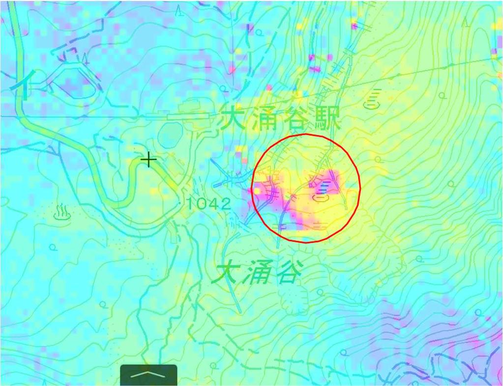
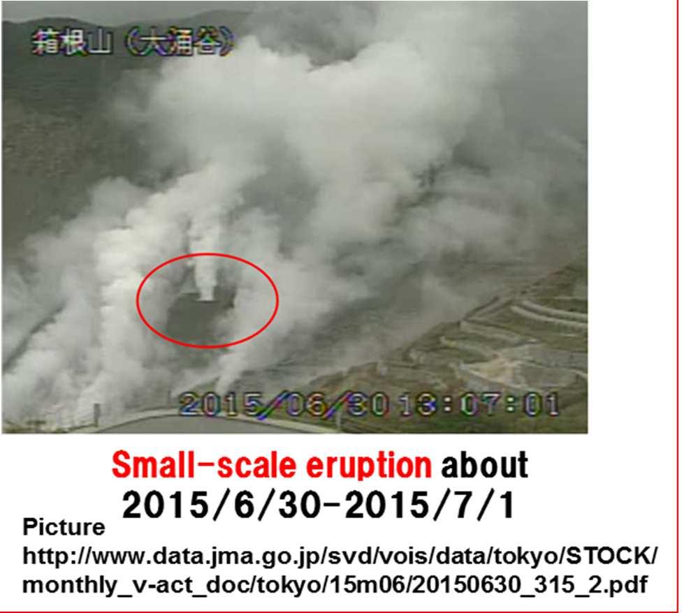

36 Monitoring Volcano by using InSAR - Mount Hakone - 200m ~ /10/9~2015/5/7 2015/3/1 ~2015/5/ /4/17 ~2015/5/ /5/7 ~2015/5/21 Volcanic eruption committee of JMA set Warning Level.
37 Contents 1. What is UN-GGIM-AP? 2. Hazards in Japan and its geological setting 3. How works ST/GIS for disaster management? (a) Prepare thematic maps to raise awareness (b) Monitoring & Early warning system (c) Quickly find the impact and damages 4. Summary 37
38 Crustal Deformation Detected by GNSS CORS The 2016 Kumamoto Earthquake (M7.3) Horizontal 98cm 45cm 76cm Co-seismic deformation detected by GNSS CORS SW-ward: max. 98 cm Upward: max. 24 cm Detected deformation data was provided to the public in a few hours after the earthquake. 24cm -19cm -19cm GNSS CORS helps find the impact and extent of potential damage caused by earthquakes. Vertical

39 CORS Data Analysis/Modeling and ALOS-2 InSAR Analysis


40 Aerial Photos GNSS CORS provides accurate positional control to the airplane. The photos revealed the impact and extent of damage in detail.


41 Geospatial Information Platform for Decision Makers Video images taken from a helicopter and ortho-rectified real-time


42 Integrated Disaster Information Mapping System DiMAPS Live Camera On-site Image Situation Center Overlaying Live Information from Different Sources on One Map Live Video by Aircraft SAR image Road warning information Information about current conditions Positional information of disaster victims Digital Map table Collapse of the XX Bridge YY Hospital Stored fuels On-site Vehicles Digital Map Table Local Government Big Data


43 Geospatial Information Platform for Decision Makers
44 Contents 1. What is UN-GGIM-AP? 2. Hazards in Japan and its geological setting 3. How works ST/GIS for disaster management? (a) Prepare thematic maps to raise awareness (b) Monitoring & Early warning system (c) Quickly find the impact and damages 4. Summary 44
45 Summary Japan has repeatedly experienced disastrous natural events, such as earthquakes, floods and landslides. In order to help keep the country resilient to these disasters, A) Prepare useful thematic maps to raise awareness of the people on the disaster risk reduction; B) Run Monitoring and Early warning system and C) Quickly find the impact and extent of damage caused by disasters to assist rescue. In all these efforts, Space Technologies and Geospatial Infrastructure plays a crucial role.
46 Catfish woodblock print In Japan 1855, people believe that Catfish occurs earthquake!


47 In Catfish Japan woodblock 1855, print people believe that Catfish occurs earthquake! Thank you!
NGIAs' roles in successful disaster response
 The Second UN-GGIM-AP Plenary Meeting NGIAs' roles in successful disaster response Japan Teheran Iran 28 October 2013 Shin-ichi SAKABE, Director of International Affairs Division Geospatial Information
How GNSS CORS in Japan works for geodetic control and disaster mitigations
 ICG Working Group D Reference Frames, Timing and Applications How GNSS CORS in Japan works for geodetic control and disaster mitigations ICG11, Nov. 7-11, 2016, Sochi, Russia Hiromichi TSUJI Geodetic Observation
Report of the Working Group 2 Data Sharing and Integration for Disaster Management *
 UNITED NATIONS E/CONF.104/6 ECONOMIC AND SOCIAL COUNCIL Twentieth United Nations Regional Cartographic Conference for Asia and the Pacific Jeju, 6-9 October 2015 Item 5 of the provisional agenda Report
KNOWLEDGE NOTE 5-1. Risk Assessment and Hazard Mapping. CLUSTER 5: Hazard and Risk Information and Decision Making. Public Disclosure Authorized
 Public Disclosure Authorized Public Disclosure Authorized Public Disclosure Authorized Public Disclosure Authorized KNOWLEDGE NOTE 5-1 CLUSTER 5: Hazard and Risk Information and Decision Making Risk Assessment
Seismic Activity and Crustal Deformation after the 2011 Off the Pacific Coast of Tohoku Earthquake
 J-RAPID Symposium March 6-7, 2013 Seismic Activity and Crustal Deformation after the 2011 Off the Pacific Coast of Tohoku Earthquake Y. Honkura Tokyo Institute of Technology Japan Science and Technology
Case Study of Japan: Crustal deformation monitoring with GNSS and InSAR
 Technical Seminar Reference Frame in Practice, Case Study of Japan: Crustal deformation monitoring with GNSS and InSAR Basara Miyahara miyahara-b96ip@milt.go.jp Geospatial Information Authority of Japan
How did the Geospatial Information Authority of Japan Respond to the 2016 Kumamoto Earthquake? 11
 How did the Geospatial Information Authority of Japan Respond to the 2016 Kumamoto Earthquake? 11 How did the Geospatial Information Authority of Japan Respond to the 2016 Kumamoto Earthquake? A Case Story
Disclaimer. This report was compiled by an ADRC visiting researcher (VR) from ADRC member countries.
 from ADRC member countries.") Disclaimer This report was compiled by an ADRC visiting researcher (VR) from ADRC member countries. The views expressed in the report do not necessarily reflect the views of the ADRC. The boundaries and
Disclaimer This report was compiled by an ADRC visiting researcher (VR) from ADRC member countries. The views expressed in the report do not necessarily reflect the views of the ADRC. The boundaries and
How did the Geospatial Information Authority of Japan. Respond to the 2016 Kumamoto Earthquake? -A Case Story- October 2017
 How did the Geospatial Information Authority of Japan Respond to the 2016 Kumamoto Earthquake? -A Case Story- October 2017 Geospatial Information Authority of Japan Contents Introduction 1 Role of Geospatial
GEO-VIII November Geohazard Supersites and Natural Laboratories Progress Report. Document 9
 GEO-VIII 16-17 November 2011 Geohazard Supersites and Natural Laboratories Progress Report Document 9 This document is submitted to GEO-VIII for information. Geohazard Supersites and Natural Laboratories
Outline of Guideline for Development and Utilization of Tsunami Disaster Management Map
 Outline of Guideline for Development and Utilization of Tsunami Disaster Management Map Port and Airport Research Institute, Japan The Overseas Coastal Area Development Institute of Japan Ports and Harbours
JICA s Experiences of Connecting Japanese Science & Technologies for Disaster Risk Reduction in Developing Countries
 JICA s Experiences of Connecting Japanese Science & Technologies for Disaster Risk Reduction in Developing Countries Junji WAKUI Deputy Director General, Group Leader Disaster Risk Reduction Group Global
Report of the Regional Committee of UN-GGIM for Asia and the Pacific (UN-GGIM-AP)
") Report of the Regional Committee of UN-GGIM for Asia and the Pacific (UN-GGIM-AP) At the Eighth Session of UN-GGIM UN Headquarters, New York, 1 3 August 2018 About UN-GGIM-AP One of the five regional committees
Report of the Regional Committee of UN-GGIM for Asia and the Pacific (UN-GGIM-AP) At the Eighth Session of UN-GGIM UN Headquarters, New York, 1 3 August 2018 About UN-GGIM-AP One of the five regional committees
Final Presentation on Disaster Risk Management in Japan. Through ADRC V. R Programme. Main Findings and Action Plan:
 Final Presentation on Disaster Risk Management in Japan Through ADRC V. R Programme Main Findings and Action Plan: Problem/Hazard and Disaster in Japan Good Practiced on Disaster Risk Management in Japan
Background Document: Report of the Regional Committee of United Nations Global Geospatial Information Management for Asia and the Pacific
 Background Document: Report of the Regional Committee of United Nations Global Geospatial Information Management for Asia and the Pacific 1. Summary 1. This report highlights the activities carried out
Case study of Japan: Reference Frames in Practice
 Case study of Japan: Reference Frames in Practice Basara Miyahara and Koji Matsuo Sponsors: 1 Outline Introduction - Geodetic reference frame of Japan - GEONET : continuous GNSS observation system Geometric
The Third UN-GGIM-AP Plenary Meeting. Use of Geospatial Information in Disaster and Coordination among NDMA and Relevant Organizations/Stakeholders
 The Third UN-GGIM-AP Plenary Meeting Use of Geospatial Information in Disaster and Coordination among NDMA and Relevant Organizations/Stakeholders Bali Indonesia 10 November 2014 Bernardus Wisnu Widjaja
NCC roles in successful disaster response I.R.IRAN
 The Second UN-GGIM-AP Plenary Meeting NCC roles in successful disaster response I.R.IRAN Teheran Iran 28-30 October 2013 Ali Javidaneh Technical Deputy of National Cartographic Center (NCC) Outline Types
Prevention Tsunami wall 10m high (breached by the tsunami due to land level falling by 3m)
") Plate margin Plates Causes Sendai, Japan Convergent plate margin Pacific and Eurasian Plates Convergent plate margin Sima (Pacific plate) moves towards the sial (Eurasian plate) Sima (Pacific plate) is
Plate margin Plates Causes Sendai, Japan Convergent plate margin Pacific and Eurasian Plates Convergent plate margin Sima (Pacific plate) moves towards the sial (Eurasian plate) Sima (Pacific plate) is
Roles of NGII in successful disaster management
 The Second UN-GGIM-AP Plenary Meeting Roles of NGII in successful disaster management Republic of Korea Teheran Iran 28 October 2013 Sanghoon Lee, Ph.D. NGII Outline Type of Disasters Occur in Korea Practical
Geodesy. orientation. shape. gravity field
 Geodesy noun Science of measuring the shape, orientation and gravity field of the Earth and how it changes over time. shape orientation gravity field Positioning has always been important Downstream applications
Report of PCGIAP to the 18 th United Nations Regional Cartographic Conference for Asia and the Pacific (UNRCC-AP) for the period
 for the period") Permanent Committee on GIS Infrastructure for Asia and the Pacific (PCGIAP) Established in 1995 by a United Nations Resolution Report of PCGIAP to the 18 th United Nations Regional Cartographic Conference
Permanent Committee on GIS Infrastructure for Asia and the Pacific (PCGIAP) Established in 1995 by a United Nations Resolution Report of PCGIAP to the 18 th United Nations Regional Cartographic Conference
Current tsunami research activities in the Philippines
 DOST PHIVOLCS Current tsunami research activities in the Philippines Graciano P. Yumul, Jr. 1,2, Carla B. Dimalanta 1 and Bart Bautista 3 1 National Institute of Geological Sciences, University of the
Geospatial application in Kiribati
 Geospatial application in Kiribati ICC-21 ST RESAP (9 TH TO 13 TH OCTOBER, 2017) BANGKOK, THAILAND Outline Kiribati Profile Natural disasters in Kiribati Achievements Challenges/Issues Ways forward 1 Kiribati
UN GGIM and National SDI Strategy
 MSDI Open Forum on 26 th January 2016 Contributing to the successful delivery of MSDI UN GGIM and National SDI Strategy Hiroshi Murakami Deputy Administrator Geospatial Information Authority of Japan Geospatial
What Are Disasters? The Rescue Kids Trio!
 The Rescue Kids Trio! What Are Disasters? This manual was made possible through funding by the Council of Local Authorities for International Relations. Disasters and emergency preparedness Emergency preparedness
Risk-based land use and spatial planning
 Risk-based land use and spatial planning Miho OHARA International Centre for Water Hazards and Risk Management (ICHARM) Public Works Research Institute PWRI), Japan Under the auspices of UNESCO Introduction
Global Map: A Tool for Disaster Mitigation for the Asia and Pacific Region
 Global Map: A Tool for Disaster Mitigation for the Asia and Pacific Region D. R. Fraser Taylor Chair, International Steering Committee for Global Mapping (ISCGM) fraser_taylor@carleton.ca www. 18 th United
Interpretive Map Series 24
 Oregon Department of Geology and Mineral Industries Interpretive Map Series 24 Geologic Hazards, and Hazard Maps, and Future Damage Estimates for Six Counties in the Mid/Southern Willamette Valley Including
Geospatial Information Management in the Americas: Lessons for the Post-2015 development agenda
 Geospatial Information Management in the Americas: Lessons for the Post-2015 development agenda Rolando Ocampo President, UN-GGIM: Americas October 2014 The integration of statistical and geographical
at IHO IRCC7 Mexico City, Mexico, June 2015
 Report on Japan s Response to Disasters presented by JHOD at IHO IRCC7 Mexico City, Mexico, 01 03 June 2015 JAPAN COAST GUARD Actions against huge earthquake Actions taken by JHOD against the Great East
Progress on the Development of the Strategic Framework on Geospatial Information and Services for Disasters
 Progress on the Development of the Strategic Framework on Geospatial Information and Services for Disasters Dr. Peter N. Tiangco Administrator, NAMRIA, Philippines Co-chair, Working Group on Geospatial
Tectonic Processes and Hazards Enquiry Question 1: Why are some locations more at risk from tectonic hazards?
 Tectonic Processes and Hazards Enquiry Question 1: Why are some locations more at risk from tectonic hazards? Key words Basalt Andesite Rhyolite Benioff Zone Subduction zone Crustal fracturing Definition
Working Group 1. Geodetic Reference Frame. Activity Report. for. The UN-GGIM-AP Plenary Meeting
 Regional Committee of United Nations Global Geospatial Information Management for Asia and the Pacific (UN-GGIM-AP) Established by a United Nations Resolution Working Group 1 Geodetic Reference Frame Activity
Disaster Management in Republic of Korea
 The Third UN-GGIM-AP Plenary Meeting Disaster Management in Republic of Korea ~Coordination among NGIA & Other Related Organizations and Recommendations~ Bali Indonesia 10 November 2014 Sanghoon Lee, Ph.D.
Monthly Volcanic Activity Report (March, 2011)
") Monthly Volcanic Activity Report (March, 2011) Japan Meteorological Agency Yakedake[ Alert Level : 1] Just after "The 2011 off the Pacific coast of Tohoku Earthquake" on 11th March, seismicity became higher
Monthly Volcanic Activity Report (March, 2011) Japan Meteorological Agency Yakedake[ Alert Level : 1] Just after "The 2011 off the Pacific coast of Tohoku Earthquake" on 11th March, seismicity became higher
Earthquake Hazards. Tsunami
 Earthquake Hazards Tsunami Measuring Earthquakes Two measurements that describe the power or strength of an earthquake are: Intensity a measure of the degree of earthquake shaking at a given locale based
Earthquake Hazards. Tsunami
 Earthquake Hazards Tsunami Review: What is an earthquake? Earthquake is the vibration (shaking) and/or displacement of the ground produced by the sudden release of energy. The point inside the Earth where
GENERAL. CHAPTER 1 BACKGROUND AND PURPOSE OF THE GUIDELINES Background of the Guidelines Purpose of the Guidelines...
 GENERAL CHAPTER 1 BACKGROUND AND PURPOSE OF THE GUIDELINES... 1 1.1 Background of the Guidelines... 1 1.2 Purpose of the Guidelines... 3 CHAPTER 2 APPLICATION OF THE GUIDELINES... 3 2.1 Potential Users
International Symposium on Earthquake & Tsunami Disaster Reduction, March 14-15, 2012, Sendai, Japan
 International Symposium on Earthquake & Tsunami Disaster Reduction, March 14-15, 2012, Sendai, Japan E h Enhancement t off earthquake th k and d volcano monitoringg in the Philippines: Progress report
Disaster Management and Spatial Data An Experience of Sri Lanka for Joint project team meeting 2012
 Disaster Management and Spatial Data An Experience of Sri Lanka for Joint project team meeting 2012 1 by Padma Kumara Withana Provincial Surveyor General Uva Province 2 Out line ü Introduction ü Natural
RESAP Progress Report
 RESAP Progress Report December 2016 to October 2017 Presentation to the Twenty-first session of the Intergovernmental Consultative Committee on the Regional Space Applications Programme for Sustainable
EXTRACTION OF FLOODED AREAS DUE THE 2015 KANTO-TOHOKU HEAVY RAINFALL IN JAPAN USING PALSAR-2 IMAGES
 EXTRACTION OF FLOODED AREAS DUE THE 2015 KANTO-TOHOKU HEAVY RAINFALL IN JAPAN USING PALSAR-2 IMAGES F. Yamazaki a, *, W. Liu a a Chiba University, Graduate School of Engineering, Chiba 263-8522, Japan
Sentinel Asia Tsunami Working Group
 Sentinel Asia Tsunami Working Group Co-Chairman: Prof. Shunichi Koshimura Abdul Muhari, PhD 4 th Joint Project Team Meeting (JPTM 2017): Sentinel Asia STEP 3 Abdul MUHARI, PhD Ministry of Marine Affairs
Wainui Beach Management Strategy (WBMS) Summary of Existing Documents. GNS Tsunami Reports
 Summary of Existing Documents. GNS Tsunami Reports") Wainui Beach Management Strategy (WBMS) Summary of Existing Documents GNS Tsunami Reports a) Review of Tsunami Hazard and Risk in New Zealand ( National Risk Report ) b) Review of New Zealand s Preparedness
Wainui Beach Management Strategy (WBMS) Summary of Existing Documents GNS Tsunami Reports a) Review of Tsunami Hazard and Risk in New Zealand ( National Risk Report ) b) Review of New Zealand s Preparedness
Status and Challenges on Geo-DRM Information Systems in Tonga
 Name: Mafua- i-vai utukakau Maka Status and Challenges on Geo-DRM Information Systems in Tonga 1 Roles and Relationships Land and Geographic Information Systems (LGIS) Unit: Establish updated high-resolution
held on 4 June 2013 Prof. Yoshimori Honkura, Program Officer of Japan Science and Technology Agency (JST) Jakarta, Indonesia Pan Pacific Hotel)
 Jakarta, Indonesia Pan Pacific Hotel)") Overview of the Outcomes from e-asia JRP Disaster Prevention Workshop held on 4 June 2013 Prof. Yoshimori Honkura, Program Officer of Japan Science and Technology Agency (JST) Jakarta, Indonesia (@Sari
Overview of the Outcomes from e-asia JRP Disaster Prevention Workshop held on 4 June 2013 Prof. Yoshimori Honkura, Program Officer of Japan Science and Technology Agency (JST) Jakarta, Indonesia (@Sari
Strategic Framework on Geospatial Information and Services for Disasters
 Strategic Framework on Geospatial Information and Services for Disasters Case Studies for the Caribbean and the Philippines --- Kunming Forum on United Nations Global Geospatial Information Management
Earthquake hazards. Aims 1. To know how hazards are classified 2. To be able to explain how the hazards occur 3. To be able to rank order hazards
 Earthquake hazards Aims 1. To know how hazards are classified 2. To be able to explain how the hazards occur 3. To be able to rank order hazards Types of hazard Primary A direct result of the earthquake
Progress Report. Flood Hazard Mapping in Thailand
 Progress Report Flood Hazard Mapping in Thailand Prepared By: Mr. PAITOON NAKTAE Chief of Safety Standard sub-beuro Disaster Prevention beuro Department of Disaster Prevention and Mitigation THAILAND E-mail:
Georeferencing and Satellite Image Support: Lessons learned, Challenges and Opportunities
 Georeferencing and Satellite Image Support: Lessons learned, Challenges and Opportunities Shirish Ravan shirish.ravan@unoosa.org UN-SPIDER United Nations Office for Outer Space Affairs (UNOOSA) UN-SPIDER
JMA Tsunami Warning Services. Tomoaki OZAKI Senior Coordinator for Tsunami Forecast Modeling Japan Meteorological Agency
 JMA Tsunami Warning Services Tomoaki OZAKI Senior Coordinator for Tsunami Forecast Modeling Japan Meteorological Agency Organization Chart of the Government of Japan Cabinet Office Diet Ministry of Internal
Risk Management Strategy
 Risk Management Strategy 1 Purpose To protect the component parts of the World Heritage property as well as the lives and the property of visitors and residents from disasters such as volcanic eruptions,
THE 2011 TOHOKU EARTHQUAKE IN JAPAN. VSU Lyuben Karavelov, Sofia, Bulgaria. Key words: Tohoku earthquake, strong ground motion, damage
 THE 2011 TOHOKU EARTHQUAKE IN JAPAN Radan Ivanov 1 VSU Lyuben Karavelov, Sofia, Bulgaria Abstract: This earthquake which occurred on March 11, 2011, had a magnitude of 9.0, which places it as the fourth
Progress Report: Sentinel Asia Success Story in the Philippines
 Progress Report: Sentinel Asia Success Story in the Philippines 3 rd Joint Project Team Meeting on the Sentinel Asia STEP-2 July 6-8, 2010 Hyatt Hotel, Manila, Philippines Renato U. Solidum Jr. Director
Special feature: Are its lessons being adequately applied? Follow-up on the ten-year anniversary of the Hanshin-Awaji Earthquake
 Special feature: Are its lessons being adequately applied? Follow-up on the ten-year anniversary of the Hanshin-Awaji Earthquake - Are we prepared for future massive earthquakes? - Hisakazu SAKAI Member
Earthquake Hazards. Tsunami
 Earthquake Hazards Tsunami Review: What is an earthquake? Earthquake is the vibration (shaking) and/or displacement of the ground produced by the sudden release of energy. The point inside the Earth where
Jeopardy. Final Jeopardy $100 $100 $100 $100 $100 $200 $200 $200 $200 $200 $300 $300 $300 $300 $400 $400 $400 $500 $500 $500 $500 $500
 Jeopardy Earthquakes Volcanoes Tsunamis Wildfires Landslides/ Droughts $100 $100 $100 $100 $100 $200 $200 $200 $200 $200 $300 $300 $300 $300 $300 $400 $400 $400 $400 $400 $500 $500 $500 $500 $500 Final
Country Report Vanuatu
 Country Report Vanuatu Ministry Infrastructure and Public Utilities. Application of Space Technology and the Geographic information system for DRR and Sustainable Development 18 th 22 nd December 2012
Australia Government Geospatial Capacity Building Efforts in Asia and the Pacific. Dr John Dawson
 Australia Government Geospatial Capacity Building Efforts in Asia and the Pacific Dr John Dawson Presentation Overview About Geoscience Australia Examples of Geospatial Capacity Building Activity Geodesy
Word Cards. 2 map. 1 geographic representation. a description or portrayal of the Earth or parts of the Earth. a visual representation of an area
 Name: Date: Hour: Word Cards 1 geographic representation a description or portrayal of the Earth or parts of the Earth Example: A map is a representation of an actual location or place. 2 map a visual
REAL-TIME ASSESSMENT OF EARTHQUAKE DISASTER IN YOKOHAMA BASED ON DENSE STRONG-MOTION NETWORK
 REAL-TIME ASSESSMENT OF EARTHQUAKE DISASTER IN YOKOHAMA BASED ON DENSE STRONG-MOTION NETWORK Saburoh MIDORIKAWA 1 And Susumu ABE 2 SUMMARY This paper describes a system for REal-time Assessment of earthquake
SDI DEVELOPMENT UPDATES OF INDONESIA
 SDI DEVELOPMENT UPDATES OF INDONESIA DR. ANTONIUS B. WIJANARTO Center For Management And Dissemination Of Geospatial Information GEOSPATIAL INFORMATION AUTHORITY GOVERNMENT OF THE REPUBLIC OF INDONESIA
Applied Geoscience and Technology Division SOPAC. Joy Papao, Risk Information Systems Officer
 Joy Papao, Risk Information Systems Officer Secretariat of the Pacific Community SPC 22 Pacific Island States Head office in Noumea, New Caledonia 2 Regional offices (Pohnpei and Honiara) 600 staff 9 Technical
Outline of Sediment Disaster Early Warning in Japan
 JICA training(disaster Management for Landslide and Sediment-related Disaster) Outline of Sediment Disaster Early Warning in Japan December 2, 2014 Masaru KUNITOMO National Institute for Land and Infrastructure
What are the social, technical, environmental and economic benefits and opportunities of accessing and sharing geodetic data?
 What are the social, technical, environmental and economic benefits and opportunities of accessing and sharing geodetic data? Graeme Blick Group Manager Positioning and Resilience Land Information New
Earthquake Source. Kazuki Koketsu. Special Session: Great East Japan (Tohoku) Earthquake. Earthquake Research Institute, University of Tokyo
 Earthquake. Earthquake Research Institute, University of Tokyo") 2012/9/24 17:20-17:35 WCEE SS24.4 Special Session: Great East Japan (Tohoku) Earthquake Earthquake Source Kazuki Koketsu Earthquake Research Institute, University of Tokyo 1 Names and features of the earthquake
2012/9/24 17:20-17:35 WCEE SS24.4 Special Session: Great East Japan (Tohoku) Earthquake Earthquake Source Kazuki Koketsu Earthquake Research Institute, University of Tokyo 1 Names and features of the earthquake
THE STUDY ON 4S TECHNOLOGY IN THE COMMAND OF EARTHQUAKE DISASTER EMERGENCY 1
 THE STUDY ON 4S TECHNOLOGY IN THE COMMAND OF EARTHQUAKE DISASTER EMERGENCY 1 Zhou Wensheng 1, Huang Jianxi 2, Li Qiang 3, Liu Ze 3 1 Associate Professor, School of Architecture, Tsinghua University, Beijing.
Heavy Rain/Flooding September 8-10 Associated with Tropical Storm Etau
 Heavy Rain/Flooding September 8-10 Associated with Tropical Storm Etau Wx Files Vol.32 September 24, 2015 Tropical Storm Etau made landfall over the Chita Peninsula in Aichi just after 10:00 AM on September
Funded by Japan Government through UN ESCAP and BMKG
 METEOROLOGY & COAST RADIO SERVICES MINISTRY OF METEOROLOGY, ENERGY, INFORMATION,DISASTER MANAGEMENT, ENVIRONMENT, CLIMATE CHANGE AND COMMUNICATION KINGDOM OF TONGA P. O. Box 845, Domestic Terminal, Fua
SEISMIC RISK ASSESSMENT IN ARMENIA
 SEISMIC RISK ASSESSMENT IN ARMENIA Hovhannes Khangeldyan Head of National Crisis Management Center Rescue Service Ministry of Emergency Situations of the Republic of Armenia Tokyo, 2016 ARMENIA: GEOGRAPHICAL
Natural Disasters in Member Countries (2002 Summary)
") 4.2 Member Countries and their Disaster Characteristics: Table 5: Natural Disasters in Member Countries (2002 Summary) (Country/Disaster Type/Disaster Characteristics) Data Country DisType Count of TotAff
4.2 Member Countries and their Disaster Characteristics: Table 5: Natural Disasters in Member Countries (2002 Summary) (Country/Disaster Type/Disaster Characteristics) Data Country DisType Count of TotAff
Overview of Philippine Geohazards Programs
 Overview of Philippine Geohazards Programs 53 rd CCOP Annual Session CCOP-IUGS Task Group on Geohazards Joint Seminar Cebu City, PHILIPPINES October 18, 2017 Renato U. Solidum, Jr. Department of Science
Geospatial Information and Services for Disasters (GIS4D)
") Geospatial Information and Services for Disasters (GIS4D) 31 July 2017 Tae Hyung KIM ICT and Disaster Risk Reduction Division (IDD) UNESCAP 1 About ESCAP Who is ESCAP? United Nations Economic and Social
Geospatial Information and Services for Disasters (GIS4D) 31 July 2017 Tae Hyung KIM ICT and Disaster Risk Reduction Division (IDD) UNESCAP 1 About ESCAP Who is ESCAP? United Nations Economic and Social
Year 9 Revision. The exam will be based on two topics: Natural hazards and Population. The Exam
 Year 9 Revision The exam will be based on two topics: Natural hazards and Population This document is designed to help you revise. You should use it alongside your class notes. In places there are some
5. Principles. 1. Malaysia is not free from. Kuala Teriang, Langkawi
 5. Principles 1. Malaysia is not free from seismic-induced geohazards. However, the degree and magnitude of the geohazards are relatively small or minor because Malaysia is located in a stable tectonic
Pacific Catastrophe Risk Assessment And Financing Initiative
 Pacific Catastrophe Risk Assessment And Financing Initiative PALAU September is expected to incur, on average,.7 million USD per year in losses due to earthquakes and tropical cyclones. In the next 5 years,
Enhancing Preparedness and Early Warning in Disaster Risk Reduction
 Enhancing Preparedness and Early Warning in Disaster Risk Reduction Fifth Technical Conference on Management of Meteorological and Hydrological Services in Regional Association V at PETALING JAYA, MALAYSIA
STUDY ON TSUNAMIGENIC EARTHQUAKE CRITERIA FOR THE INDONESIAN TSUNAMI EARLY WARNING SYSTEM
 STUDY ON TSUNAMIGENIC EARTHQUAKE CRITERIA FOR THE INDONESIAN TSUNAMI EARLY WARNING SYSTEM Nanang T. Puspito 1 1 Geophysics Research Group, Faculty of Mining and Petroleum Engineering, Institute of Technology
ESCAP Promotes Geo-referenced Information System for Disaster Risk Management in Asia and the Pacific
 Third High Level Forum on UNGGIM 22-24 October 2014 Beijing, China ESCAP Promotes Geo-referenced Information System for Disaster Risk Management in Asia and the Pacific Keran Wang Space Applications Section,
SURVEY PORTRAY SAFEGUARD
 SURVEY GSI (Headquarters) and Science Museum of Map and Survey Kokudochiriin (GSI) Main Bldg. P Science Museum of Map and Survey Main gate P Kokudochiriin (GSI) PORTRAY Tokyo SAFEGUARD 1 2 3 4 3 4 5 6
Disaster RISK Management : Bhutanese Scenario
 Disaster RISK Management : Bhutanese Scenario Expert Group Meeting (EGM) on Geo-referenced Information Systems for Disaster Risk Management (Geo-DRM) and sustaining the Community of Practice (COP), Bangkok,
GUIDELINES FOR CONSTRUCTION TECHNOLOGY TRANSFER DEVELOPMENT OF WARNING AND EVACUATION SYSTEM AGAINST SEDIMENT DISASTERS IN DEVELOPING COUNTRIES
 GUIDELINES FOR CONSTRUCTION TECHNOLOGY TRANSFER DEVELOPMENT OF WARNING AND EVACUATION SYSTEM AGAINST SEDIMENT DISASTERS IN DEVELOPING COUNTRIES MARCH 2004 Ministry of Land, Infrastructure and Transport
FIG Asia Pacific Capacity Development Network
 FIG Asia Pacific Capacity Development Network Report to the 41th General Assembly FIG Congress 2018, Istanbul - Turkey Rob Sarib Chair FIG Asia Pacific Capacity Development Network (AP CDN) Story of the
Pacific Catastrophe Risk Assessment And Financing Initiative
 Pacific Catastrophe Risk Assessment And Financing Initiative VANUATU September 211 Country Risk Profile: VANUATU is expected to incur, on average, 48 million USD per year in losses due to earthquakes and
Lessons Learned from Past Tsunamis Warning and Emergency Response
 UNESCO IOC CTIC US NOAA ITIC Regional Training Workshop on Strengthening Tsunami Warning and Emergency Response Standard Operating Procedures and the Development of the ICG/CARIBE-EWS PTWC New Enhanced
Pacific Catastrophe Risk Assessment And Financing Initiative
 Pacific Catastrophe Risk Assessment And Financing Initiative TIMOR-LESTE September Timor-Leste is expected to incur, on average, 5.9 million USD per year in losses due to earthquakes and tropical cyclones.
Outline and Future Strategies of SABO Works in Japan. Koji Nishiyama
 Outline and Future Strategies of SABO Works in Japan Koji Nishiyama Director General Sabo Department, Ministry of Land, Infrastructure, Transport and Tourism -MLIT Japan Jun. 15th, 2017 The 10 th Japan-Italy
4-3-1 Earthquake and Tsunami Countermeasures of Tokyo s
 4-3-1 Earthquake and Tsunami Countermeasures of Tokyo s Sewerage Masahiro Hikino* and Gaku Sato** *Planning Section, Planning and Coordinating Division, Bureau of Sewerage, Tokyo Metropolitan Government
JMA Tsunami Warning Services. Takeshi KOIZUMI Senior Coordinator for International Earthquake and Tsunami Information Japan Meteorological Agency
 JMA Tsunami Warning Services Takeshi KOIZUMI Senior Coordinator for International Earthquake and Tsunami Information Japan Meteorological Agency Tectonic Setting of Japan (Headquarters for Earthquake Research
Hazard Resilience Index (HRI) Earthquakes, Tsunamis, and Volcanoes
 Earthquakes, Tsunamis, and Volcanoes") Hazard Index (HRI) Earthquakes, Tsunamis, and Volcanoes Earthquakes Tsunamis Volcano-Ash Falls, Projectiles and Lateral Blasts, Pyroclastic Flows and Lava Flows Earthquakes, Tsunamis and Volcanoes Please
Hazard Index (HRI) Earthquakes, Tsunamis, and Volcanoes Earthquakes Tsunamis Volcano-Ash Falls, Projectiles and Lateral Blasts, Pyroclastic Flows and Lava Flows Earthquakes, Tsunamis and Volcanoes Please
Development of the Kingdom of Tonga Cyclone Emergency Recovery and Management System using Geospatial Tools
 Development of the Kingdom of Tonga Cyclone Emergency Recovery and Management System using Geospatial Tools Case Studies from Small Island States FIG Commissions 3, 7 and 8 Malcolm Archbold General Manager
UNIVERSITY GADJAH MADA EUBIOS YOUTH LOOKING BEYOND DISASTER (LBD5) FORUM 4-8 SEPTEMBER, Hosted by: Universitas Gadjah Mada
 FORUM 4-8 SEPTEMBER, Hosted by: Universitas Gadjah Mada") UNIVERSITY GADJAH MADA EUBIOS YOUTH LOOKING BEYOND DISASTER (LBD5) FORUM 4-8 SEPTEMBER, 2014 Hosted by: Universitas Gadjah Mada Outline LBD program Brief Information of Universitas Gadjah Mada, Indonesia
UNIVERSITY GADJAH MADA EUBIOS YOUTH LOOKING BEYOND DISASTER (LBD5) FORUM 4-8 SEPTEMBER, 2014 Hosted by: Universitas Gadjah Mada Outline LBD program Brief Information of Universitas Gadjah Mada, Indonesia
Strategic Framework on Geospatial Information and Services for Disasters Relevance for the Americas Region
 Strategic Framework on Geospatial Information and Services for Disasters Relevance for the Americas Region Seventh Session of the Committee of Experts on UN-GGIM Side Event --- UN Headquarters, New York
What is an Earthquake?
 Earthquakes What is an Earthquake? Earthquake - sometimes violent shaking of ground caused by movement of Earth s tectonic plates; creates seismic waves Often followed by smaller earthquakes (aftershocks);
New A-Level Physical Geography
 Half Term 1 3.1 Physical Geography: 3.1.5 Hazards: Plate Tectonics This optional section of our specification focuses on the lithosphere and the atmosphere, which intermittently but regularly present natural
Japanese Programs on Space and Water Applications
 Japanese Programs on Space and Water Applications Tamotsu IGARASHI Remote Sensing Technology Center of Japan June 2006 COPUOS 2006 Vienna International Centre Water-related hazards/disasters may occur
Journey of supporting CSNs to establish Geo-DRM
 Regional Workshop on Geo-referenced Information Systems for Disaster Risk Management (Geo-DRM) 26-27 June 2014 Bangkok, Thailand Journey of supporting CSNs to establish Geo-DRM Keran Wang Chief, Space
Public Disclosure Copy
 Public Disclosure Authorized EAST ASIA AND PACIFIC Vanuatu Social, Urban, Rural and Resilience Global Practice Global Practice Recipient Executed Activities Technical Assistance Loan FY 2013 Seq No: 7
Building Institutional Capacity for Multi-Hazard Early Warning in Asia and the Pacific Subtitle
 Building Institutional Capacity for Multi-Hazard Early Warning in Asia and the Pacific Subtitle Title Keran Wang Chief, Space Applications Section ICT and Disaster Risk Reduction Division 22 May 2018 Pillar