The Role Of Ina-SDI For Disaster Management
|
|
|
- Ashley Young
- 6 years ago
- Views:
Transcription


 COMPONENT FOR")
1 The Second UN-GGIM-AP Plenary Meeting The Role Of Ina-SDI For Disaster Management Indonesia Tehran - Iran 28 October 2013 Dodi Sukmayadi Geospatial Information Authority of Indonesia (BIG) COMPONENT FOR GEOSPATIAL DATA SHARING 1
: 1. POLICY a. State Law No. 4 / 2011: Geospatial Information; b. Presidential Regulation No.")
 between Ministry of Interior, Ministry of Communication and Information, and BIG. ACT NO.")

2 WG2: Initial Research on Existing National and International Geoportals for the Sharing of Data and Information Related to Disaster Management Five Basic Components of NSDI have been applied and implemented by the National Geospatial Authority of Indonesia (BIG - Badan Informasi Geospasial): 1. POLICY a. State Law No. 4 / 2011: Geospatial Information; b. Presidential Regulation No. 94 / 2011: National Geospatial Information Authority (BIG); c. Presidential Regulation No. 6 / 2012: Ortho-Rectified Hi-Res Satellite Imageries; d. Presidential Regulation No. 85 /2007 and No. Xx / 2013: National Geospatial Information Network and Sharing; e. Mutual Regulation (being implemented) between Ministry of Interior, Ministry of Communication and Information, and BIG. ACT NO. 4 YEAR 2011 POLICY AND IMPLEMENTATION 1. TO ENDORSE SINGLE REFERENCE FOR INTEGRITY OF GEOSPATIAL INFORMATION IN INDONESIA; 2. TO ENSURE THE AVAILABILITY AND ACCESS OF GEOSPATIAL INFORMATION WITH ACCOUNTABILITY; 3. TO ACHIEVE USEFULNESS OF GEOSPATIAL INFORMATION THROUGH COOPERATION, COORDINATION, INTEGRATION AND SYNCHRONIZATION; AND 4. TO ENCOURAGE THE USE OF GEOSPATIAL INFORMATION IN GOVERNMENT ACTIVITY AND PEOPLE'S DAILY LIFE LAW 4/2011, ARTICLE 22 GEOSPATIAL INFORMATION AUTHORITY 2


")
 expanded to be PerPres")
3 ACT NO. 4 YEAR 2011 TRANSFORMATION IN PARADIGM AND INSTITUTION BAKOSURTANAL INSTITUTIONS OF NATIONAL ADVISER IN DEVELOPMENT OF SURVEY, MAPPING, AND SPATIAL DATA INFRASTRUCTURE GEOSPATIAL INFORMATION AGENCY THE NATIONAL ORGANIZER IN THE FIELD OF THE TOPOGRAPHIC SURVEY AND BASE MAPPING INSTITUTIONS OF NATIONAL ADVISER IN DEVELOPMENT OF THEMATIC MAPS THE NATIONAL ORGANIZER FOR SPATIAL DATA INFRASTRUCTURE LAWS AND REGULATION CONCERNING GEOSPATIAL INFORMATION UU No. 4 / 2011 : Geospatial Information Presidential Decree No. 94 / 2011 : Roles and Functions of Geospatial Information Authority (BIG) Presidential Decree No. 85 / 2007 : National Geospatial Data Network (JDSN) expanded to be PerPres No. / 2013 National Geospatial Information Network (JIGN) Presidential Instruction No. 6 / 2012 : Provision, Use, Quality Control, Processing, and Distribution of Ortho- Rectified Hi-Res Satellite Imageries 3
4 WG2: Initial Research on Existing National and International Geoportals for the Sharing of Data and Information Related to Disaster Management Five Basic Components of NSDI have been applied and implemented by the National Geospatial Authority of Indonesia (BIG - Badan Informasi Geospasial): 2. INSTITUTIONAL a. BIG was established in 2012; b. Memorandum of Understanding (MoU) on Geospatial Information Sharing and Network Node with many Ministries and Provincial/Regency- Municipal Governments; c. Center for Assessment and Development of SDI with 8 (eight) Universities; d. Community-based Participatory Mapping. WG2: Initial Research on Existing National and International Geoportals for the Sharing of Data and Information Related to Disaster Management Five Basic Components of NSDI have been applied and implemented by the National Geospatial Authority of Indonesia (BIG - Badan Informasi Geospasial): 3. DATA and STANDARD a. Seamless Basic Geospatial Data (2,500k / 250k / 50k / 25k) of BIG and many Thematic Geospatial Data from Ministries were improved (one map policy) & published on Indonesia Geospatial Portal (Ina-GeoPortal); b. National Standard of Geospatial Features and Catalog, and adoption of ISO Metadata as the National Standard. 4
5 GEOSPATIAL INFORMATION ROLE IN INDONESIAN SUSTAINABLE DEVELOPMENT DECENTRALIZATION AND REGIONAL AUTONOMY DATABASE PLANNING FOUNDATION APPROACH BY ZONE NATIONAL GOALS GEOSPATIAL INFORMATION STATISTICS/ CENSUS SPATIAL PLANNING CADASTER MANAGEMENT FAST GROWING BOUNDARY/FRONTIE R LEAST DEVELOPED DISASTER RISK SOCIAL CONFLICT URBAN SYSTEM RURAL LOCAL ECONOMIC DEVELOPMENT TRANSMIGRATION ISLANDS AND PROVINCIAL PLANNING DIRECTIVE INTER REGION GAP REDUCTION PROSPERITY ACCELERATION NEW INDONESIAN GEOSPATIAL REFERENCE SYSTEM (Ina-GRS2013) Indonesia has lauched a new Indonesian Geospatial Reference System on Oct 17 th, 2013 which is called Ina-GRS2013. Ina-GRS2013 replaced the former Indonesian National Geodetic Datum (DGN95) by considering tectonic plate movement and crustal deformation into its reference system. It will be used as a single geospatial reference system throughout the country. Details: 1. GRS Name : Indonesian Geospatial Reference System (Ina-GRS2013) 2. Reference frame : National Geodetic Control Network tied to ITRF Reference epoch for Ina-GRS 2013 : ( 1 January 2012) 4. Vertical Datum: Geoid 5. Include a Deformation Model / Velocity model 5


")

 0 1:500,000")
 1,471 1:25,000")
 90,889 1:5,000 379,014 128 (0.")
6 LARGE MEDIUM SMALL Ina-GRS 2013 REALIZATION CORS GNSS Distribution 2013 Indonesian Geoid for Kalimantan & Sulawesi Horizontal Control Network Distribution Vertical Control Network Distribution STATUS 2013: BASE MAPPING Aerial photo s Airborne IFSAR Airborne LIDAR Satellite SAR DATA ACQUISITION STEREO PLOTTING DTM (contour lines) Topomap features Accuracy Test Toponyms Administrative Boundary FIELD SURVEY DATABASE Topology Seamless-ing Cartography Digital Map Gazetteer PRODUCTS BASEMAP SCALE TOTAL AVAILABLE TO DO 1:1,000, (100%) 0 1:500, (100%) 0 1:250, (100%) 0 1:100,000 1, ,245 1:50,000 3,899 2,417 (62%) 1,471 1:25,000 13, (14%) 11,246 1:10,000 91, (0.7%) 90,889 1:5, , (0.003%) 378,458 1:2, , ,206 1:1,000 2,729, ,729,319 6

7 STATUS 2013: THEMATIC MAPPING Risk Map BMKG, PU, BIG, ESDM Sectoral Zonation Permit Map BPN, KEMENHUT, ESDM Land Cover map BIG, KEMENHUT, LH, LAPAN Earthquake Distribution Map ESDM, BMKG Ortho High Resolution Imagery BIG, LAPAN 11 NATIONAL WORKING GROUP FOR THEMATIC MAPPING NATURAL RESOURCE AND WATERSHED FARMING AND PEATLAND RESOURCE DYNAMIC CLIMATE CHANGE ECOREGION TRANSPORTATION DISASTER STUDY SPATIAL PLANNING MARINE RESOURCES, COASTAL, AND SMALL ISLANDS SECTORAL COORDINATION AND SINERGY FOR ONE MAP POLICY SOCIAL, ECONOMY,CULTURE AND ATLAS SECTORAL ZONATION, LAND COVER, AND LAND STATUS WG2: Initial Research on Existing National and International Geoportals for the Sharing of Data and Information Related to Disaster Management Five Basic Components of NSDI have been applied and implemented by the National Geospatial Authority of Indonesia (BIG - Badan Informasi Geospasial): 4. TECHNOLOGY a. Indonesia Geospatial Portal (Ina-GeoPortal) was launched in 2012; b. National Geospatial Data Center (Tier 3), Disaster Recovery Center, Geospatial Cloud & High Performance Computing Services; c. National Standard on Geospatial Reference System, Continuous Orientation Reference System (CORS) Services; d. National Internet exchange (NIX) for Geospatial Information Communication Infrastructure. 7


8 CERTIFICATION LICENSING LICENSING ACCREDITATION WG2: Initial Research on Existing National and International Geoportals for the Sharing of Data and Information Related to Disaster Management Five Basic Components of NSDI have been applied and implemented by the National Geospatial Authority of Indonesia (BIG - Badan Informasi Geospasial): 5. HUMAN RESOURCES a. Professional Certification based on National Occupational Competency Standards, Licensing for Geospatial Information Services Industry; b. Capacity Building: NSDI Training Center, Promotion & Socialization. LEVERAGING GEOSPATIAL INDUSTRY RE-ASSESMENT INDUSTRY AND NATIONAL NEEDS ASSESSMENT COMPETENCE STANDARDS PREPARATION NATIONAL MAPPING AGENCY MIN. OF LABOR AND TRANSMIGRATION IMPLEMENTATION VERIFICATION NATIONAL COMPETENCE STANDARD DETERMINATION ON COMPETENCE STANDARDS PRE-CONVENSION INDEPENDENT INSTITUTION CONVENTION VERIFICATION Min. of Labor Decree No. 8/2012 PROFESSIONALS COMPANIES TRAINING INSTITUTIONS 8


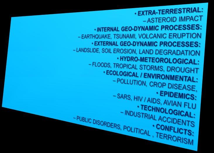
9 Regencies/ Municipal. Provinces Ministries/ Agencies STATUS 2013: Ina-SDI DEVELOPMENT Produk Peta & Data Portal GEOSPATIAL CLOUD COMPUTING DATA CENTER NATIONAL GEOPORTAL Desktop View,Editing & Analizing Aplikasi Web Services TARGET CONNECTED TO DO Survei Lapangan & Mobile Map Sistim Penyelenggaraan IG BIG : 1. Data Collection & Processing 2. Data Management 3. Geodatabase Management 4. Production Management 5. Publication Management 6. Utilizing INDONESIA: FACING MOST KIND OF HAZARDS VOLCANO ERUPTION EARTHQUAKE ARTIFICIAL FAILURE TSUNAMI FLOOD FOREST FIRE 9
10 INDONESIA: FACING MOST KIND OF HAZARDS Asia-Pacific Disaster Report 2010 stated that people in the Asia Pacific is 4 times more susceptible than in Africa and 25 times more vulnerable than in North America and Europe. [1] United Nations International Strategy for Disaster Reduction (UNISDR) rank Indonesia first in the two natural disasters (tsunami and landslide), ranking third in the earthquake, and ranked sixth in the flood natural disasters occurred over the past 5 years ( ) in Indonesia: 71 earthquakes; 2 Tsunami; 24 Volcanic eruption; 469 landslide events; 1916 floods; 158 Flooding with landslides; 1083 Drought; 580 Hurricanes; and 105 Tides. The UN report estimates that more than 18 million peoples affected by natural disasters in Indonesia from 1980 to KEY INSTITUTIONS IN DISASTER MANAGEMENT BNPB is the Indonesian National Board for Disaster Management (Indonesian: Badan Nasional Penanggulangan Bencana), has the task to assist the President of the Republic of Indonesia: planning and coordinating the implementation of disaster management and emergency response activities in an integrated manner; and implement disaster management and emergency response from before, during, and after including disaster prevention, preparedness, emergency response, and recovery. BIG is the Geospatial Information Agency (Indonesian: Badan Informasi Geospasial), has the task to assist the President of the Republic of Indonesia: planning, organizing and coordinating the development of geospatial information for disaster management activities. [1] ) 10


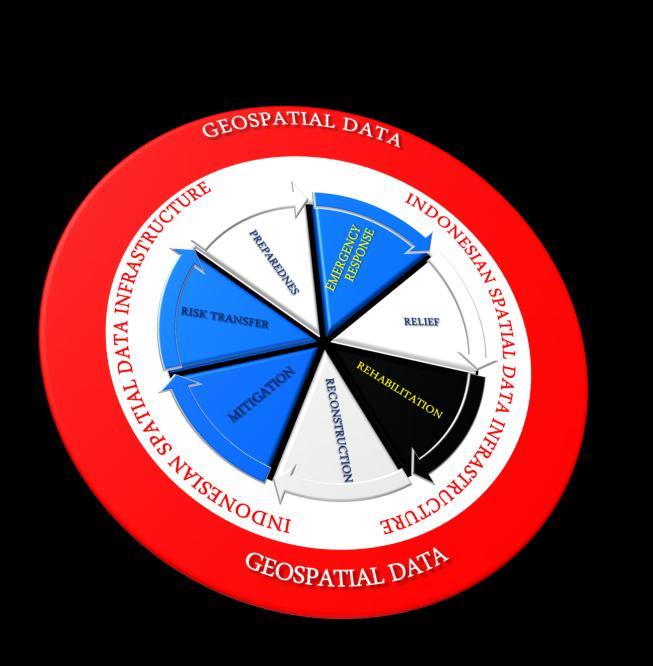


11 Ina-SDI ROLE IN DISASTER MANAGEMENT COMPONENT FOR GEOSPATIAL DATA SHARING 11


12 PILLARS of Ina-SDI FOR DISASTER MANAGEMENT Institutional Arrangement Science and Technology Human Resource Standardized Geospatial Data Laws And Rules Ina-SDI S WORKING ELEMENTS STANDARD Acquisition Management Visualization Access Integration Analisys Quality Control Quality Assurance INTEROPABILITY GUIDANCE AND SPECIFICATION GEOSPATIAL INFORMATION METADATA Accuracy Availability Land Cover Completeness others CONTRIBUTORS GOVERNMENTS ONE MAP POLICY SDI ARRANGEMENT INSTITUTIONAL ARRANGEMENT DATA SCALE AND RESOLUTION PRIVATE AND VENDORS ACCESS POLICY IMPLEMENTATION OF STANDARD METADATA COMMUNITIES SDI COMMITTEE CAPACITY BUILDING DATA MANAGEMENT DATA ACQUISITION HUMAN RESOURCES CERTIFIED PROFESSIONALS ACADEMICS WELL-INFORMED DECISION MAKERS GEOPORTAL SOFTWARE GEO-ICT HARDWARE AND NETWARE DATABASE MANAGEMENT SYSTEM ACCESS DAN ANALYSIS TYPE OF DATA 12

13 Ina-SDI READINESS FOR DISASTER EVENT 57 MINISTRIES, 34 PROVINCIAL, AND 508 MUNICIPALITIES MUNICIPAL GEOSPATIAL INFORMATION AUTHORITY CUSTODIAN CUSTODIAN MUNICIPAL DATA CENTER METADATA CATALOG PORTAL CLEARINGH OUSE UNIT NATIONAL DATA CENTER CLEARINGHOUSE UNIT METADATA CATALOG PORTAL NATIONAL GEOPORTAL DISASTER MANAGEMENT AGENCY CUSTODIAN BUREAU UNIT OFFICE OTHER MINISTIRES OTHER LOCAL GOVT CLEARINGHOUSE UNIT METADATA CATALOG PORTAL LOCAL DISASTER MANAGEMENT AGENCY CLEARINGHOUSE UNIT METADATA CATALOG PORTAL CLEARINGHOUSE UNIT METADATA CATALOG PORTAL NATIONAL DATA CENTER Ina-GeoPortal : or 13

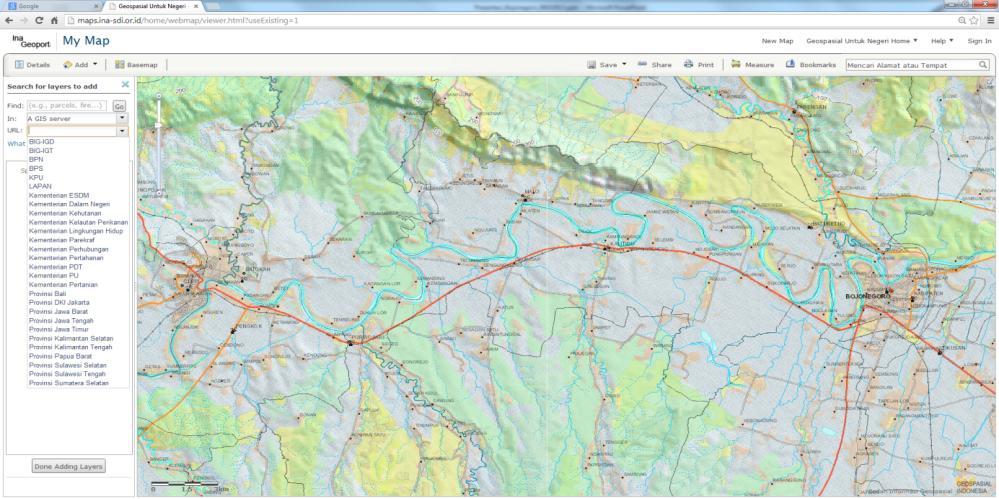
14 Ina-GEOPORTAL : SERVICING MEMBER OF INA-SDI AND PUBLIC WITH MULTI-SCALE BASEMAP Ina-GEOPORTAL : SERVICING MEMBER OF INA-SDI AND PUBLIC WITH MULTI-SCALE BASEMAP 14

15 Ina-GEOPORTAL : SERVICING MEMBER OF INA-SDI AND PUBLIC WITH MULTI-SCALE BASEMAP GEOSPATIAL SUPPORT COMMAND CENTER BETTER DECISION MAKING WITH COMMON OPERATING MAPS ANALYZING VISUALIZING PLANNING GEO-ACCOUNTING GEOSPATIAL SUPERIORITY MAPPING GEO-MONITORING ACTING LOCAL GOVERNMENT DECISION MAKING MAPPING AGENCY INDONESIAN SDI COMMUNITY CAPABILITY MINISTRIES ARMED FORCES/POLICE GOVERNANCE IN THE FIELD OF SURVEYING, MAPPING AND GEOSPATIAL DATA INFRASTRUCTURE IN PROVIDING TIMELY, RELEVANT, AND ACCURATE GEOSPATIAL INFORMATION TO SUPPORT OF DISASTER MANAGEMENT 15


16 ORGANIZATION AL TECHNICAL POLITICAL DRAW BACK KENDALA PURPOSE RESUME : Ina-SDI FOR DISASTER MANAGEMENT CHALLENGES AND OPPORTUNITY TECH TEKNOLOGI TUJUAN GOAL NEEDS KEBUTUHAN PENGGUNA DATA MGT MANAJEMEN DATA PARADIGMA SISTEM INFORMASI PARADIGM PERSONAL KEINGINAN PENGGUNA DEMAND SASARAN APPS APLIKASI OPPOR- PELUANG TUNITY Our strength is strong political support, has stated strong organizations' vision and underlying measurable missions. Our challenges lies in in technical level and personal level, both in quantity and quality. Our plan to overcome these challenges is to empower academia through establishing SDI Centers in 8 top universities and Constructing new standard of competence and professionalism, both in government and the geospatial related industries. Thank You See You in Bali با تشکر از شما 16
SDI DEVELOPMENT UPDATES OF INDONESIA
 SDI DEVELOPMENT UPDATES OF INDONESIA DR. ANTONIUS B. WIJANARTO Center For Management And Dissemination Of Geospatial Information GEOSPATIAL INFORMATION AUTHORITY GOVERNMENT OF THE REPUBLIC OF INDONESIA
INDONESIA S S UPDATE: GEOSPATIAL INFORMATION FOR SUSTAINABLE DEVELOPMENT RELATED TO INA SDI Dr. Asep Karsidi, M.Sc
 INDONESIA S S UPDATE: GEOSPATIAL INFORMATION FOR SUSTAINABLE DEVELOPMENT RELATED TO INA SDI Dr. Asep Karsidi, M.Sc GEOSPATIAL INFORMATION AGENCY 08 August, 2012 OUTLINE 1. Transformation Bakosurtanal into
Strengthening Geospatial Information Management in Indonesia
 b Strengthening Geospatial Information Management in Indonesia Prof. Dr. Hasanuddin Z. Abidin Head (President) Geospatial Information Agency of Indonesia The 5 th High Level Forum United Nations Global
Development of Geospatial Information in Indonesia: Progress & Challenge
 Development of Geospatial Information in Indonesia: Progress & Challenge Dr. Nurwadjedi Sarbini Deputy of Thematic Geospatial Information Geospatial Information Agency (BIG) Geosmart Asia, September 29
The Third UN-GGIM-AP Plenary Meeting. Use of Geospatial Information in Disaster and Coordination among NDMA and Relevant Organizations/Stakeholders
 The Third UN-GGIM-AP Plenary Meeting Use of Geospatial Information in Disaster and Coordination among NDMA and Relevant Organizations/Stakeholders Bali Indonesia 10 November 2014 Bernardus Wisnu Widjaja
Voices from Private Sector: Insights for Future NSDI Development in Indonesia
 Voices from Private Sector: Insights for Future NSDI Development in Indonesia Ta n d a n g Yu l i a d i D w i P u t ra, Ryosuke S h i b a s a k i I n st i t u t e o f I n d u st r i a l S c i e n c e,
Disaster Management in Mongolia
 The Third UN-GGIM-AP Plenary Meeting Disaster Management in Mongolia ~Coordination among NGIA & Other Related Organizations and Recommendations~ Bali Indonesia 10 November 2014 Khurelshagai Ayurzana, Director
Report of the Working Group 2 Data Sharing and Integration for Disaster Management *
 UNITED NATIONS E/CONF.104/6 ECONOMIC AND SOCIAL COUNCIL Twentieth United Nations Regional Cartographic Conference for Asia and the Pacific Jeju, 6-9 October 2015 Item 5 of the provisional agenda Report
Report of PCGIAP to the 18 th United Nations Regional Cartographic Conference for Asia and the Pacific (UNRCC-AP) for the period
 for the period") Permanent Committee on GIS Infrastructure for Asia and the Pacific (PCGIAP) Established in 1995 by a United Nations Resolution Report of PCGIAP to the 18 th United Nations Regional Cartographic Conference
Permanent Committee on GIS Infrastructure for Asia and the Pacific (PCGIAP) Established in 1995 by a United Nations Resolution Report of PCGIAP to the 18 th United Nations Regional Cartographic Conference
NGIAs' roles in successful disaster response
 The Second UN-GGIM-AP Plenary Meeting NGIAs' roles in successful disaster response Japan Teheran Iran 28 October 2013 Shin-ichi SAKABE, Director of International Affairs Division Geospatial Information
The Integration of Land and Marine Spatial Data Set As Part of Indonesian Spatial Data Infrastructure Development
 UNITED NATIONS E/CONF.97/6/IP. 46 ECONOMIC AND SOCIAL COUNCIL Seventeenth United Nations Regional Cartographic Conference for Asia and the Pacific Bangkok, 18-22 September 2006 Item 7 of the provisional
Roles of NGII in successful disaster management
 The Second UN-GGIM-AP Plenary Meeting Roles of NGII in successful disaster management Republic of Korea Teheran Iran 28 October 2013 Sanghoon Lee, Ph.D. NGII Outline Type of Disasters Occur in Korea Practical
Disaster Management in Republic of Korea
 The Third UN-GGIM-AP Plenary Meeting Disaster Management in Republic of Korea ~Coordination among NGIA & Other Related Organizations and Recommendations~ Bali Indonesia 10 November 2014 Sanghoon Lee, Ph.D.
UN GGIM and National SDI Strategy
 MSDI Open Forum on 26 th January 2016 Contributing to the successful delivery of MSDI UN GGIM and National SDI Strategy Hiroshi Murakami Deputy Administrator Geospatial Information Authority of Japan Geospatial
From PCGIAP to UN GGIM AP: A Regional Perspective on GGIM
 Regional Committee of United Nations Global Geospatial Information Management for Asia and the Pacific (UN-GGIM-AP) Established by a United Nations Resolution From PCGIAP to UN GGIM AP: A Regional Perspective
Report of the Regional Committee of UN-GGIM for Asia and the Pacific (UN-GGIM-AP)
") Report of the Regional Committee of UN-GGIM for Asia and the Pacific (UN-GGIM-AP) At the Eighth Session of UN-GGIM UN Headquarters, New York, 1 3 August 2018 About UN-GGIM-AP One of the five regional committees
Report of the Regional Committee of UN-GGIM for Asia and the Pacific (UN-GGIM-AP) At the Eighth Session of UN-GGIM UN Headquarters, New York, 1 3 August 2018 About UN-GGIM-AP One of the five regional committees
Realizing benefits of Spatial Data Infrastructure A user s perspective from Environment Agency - Abu Dhabi
 Realizing benefits of Spatial Data Infrastructure A user s perspective from Environment Agency - Abu Dhabi Anil Kumar Director, Environment Information Management 26 April 2012 Geospatial World Forum,
COUNTRY REPORT THE SEVENTEENTH PERMANENT COMMITTEE ON GIS INFRASTRUCTURE FOR ASIA AND THE PACIFIC (PCGIAP) MEETING JULY 21 22, 2011,
 MEETING JULY 21 22, 2011,") COUNTRY REPORT INDONESIA ACTIVITIES IN 2010 THE SEVENTEENTH PERMANENT COMMITTEE ON GIS INFRASTRUCTURE FOR ASIA AND THE PACIFIC (PCGIAP) MEETING JULY 21 22, 2011, CHINGGIS KHAAN HOTEL, ULAANBAATAR CITY,
COUNTRY REPORT INDONESIA ACTIVITIES IN 2010 THE SEVENTEENTH PERMANENT COMMITTEE ON GIS INFRASTRUCTURE FOR ASIA AND THE PACIFIC (PCGIAP) MEETING JULY 21 22, 2011, CHINGGIS KHAAN HOTEL, ULAANBAATAR CITY,
Norwegian spatial data infrastructure supporting disaster risk management Norwegian Mapping Authority
 Norwegian spatial data infrastructure supporting disaster risk management Norwegian Mapping Authority Arvid Lillethun, Norwegian Mapping Authority Land and Poverty 2018 Conference, World Bank 19.-23. March
The Integrated Ge spatial Information Framework to the strengthening of NSDI, Mongolia
 Young Geospatial Professionals Summit 21 NOV 2018 The Integrated Ge spatial Information Framework to the strengthening of NSDI, Mongolia BAYARMAA ENKHTUR Geospatial information and technology department
One Map Policy to Support National Development in Indonesia
 One Map Policy to Support National Development in Indonesia Dr. Nurwadjedi Sarbini Deputy of Thematic Geospatial Information Geospatial Information Agency (BIG) Geosmart Asia, September 29 October 1, 2015
NCC roles in successful disaster response I.R.IRAN
 The Second UN-GGIM-AP Plenary Meeting NCC roles in successful disaster response I.R.IRAN Teheran Iran 28-30 October 2013 Ali Javidaneh Technical Deputy of National Cartographic Center (NCC) Outline Types
THE ROLE OF GEOSPATIAL AT THE WORLD BANK
 THE ROLE OF GEOSPATIAL AT THE WORLD BANK INSPIRE Conference Barcelona, Spain September 26, 2016 Kathrine Kelm Senior Land Administration Specialist Global Land and Geospatial Unit The World Bank Group
Integration Activities in Indonesia: The Integration of Land and Marine Spatial Data Sets as Part of Indonesian SDI Development
 Integration Activities in Indonesia: The Integration of Land and Marine Spatial Data Sets as Part of Indonesian SDI Development M. Arief Syafi i National Coordination Agency for Surveys and Mapping (B
Philippines NSDI Foundation Data Program. Andrew Bashfield
 Philippines NSDI Foundation Data Program Andrew Bashfield 1 Overview Part 1: Building the NSDI Framework Part 2: Collecting Foundation Datasets 2 Building the NSDI Framework Background & NDSI Overview
Maritime Continent of Indonesia
 The Application of for Natural Resources Management in Indonesia Prof. Dr. Hasanuddin Z. Abidin Head Agency of Indonesia (BIG) Presented at the United Nations World Congress (UNWGIC) Deqing, Zhejiang Province,
Use of geo-referenced data for DRM in Central Asia, problems and prospective
 Use of geo-referenced data for DRM in Central Asia, problems and prospective Dr. Akylbek Chymyrov Director, Kyrgyz Center of Geoinformation Systems Member of the Public Supervisory Board MES KR KSUCTA,
Country Report on SDI Activities in Singapore *
 UNITED NATIONS E/CONF.100/CRP.9 ECONOMIC AND SOCIAL COUNCIL Eighteenth United Nations Regional Cartographic Conference for Asia and the Pacific Bangkok, 26-29 October 2009 Item 7(a) of the provisional
Brazil Paper for the. Second Preparatory Meeting of the Proposed United Nations Committee of Experts on Global Geographic Information Management
 Brazil Paper for the Second Preparatory Meeting of the Proposed United Nations Committee of Experts on Global Geographic Information Management on Data Integration Introduction The quick development of
GEOMATICS. Shaping our world. A company of
 GEOMATICS Shaping our world A company of OUR EXPERTISE Geomatics Geomatics plays a mayor role in hydropower, land and water resources, urban development, transport & mobility, renewable energy, and infrastructure
NATIONAL FRAMEWORK FOR FLOOD DISASTER MANAGEMENT IN INDONESIA. 11 th GEOSS ASIA PASIFIC SYMPOSIUM Kyoto, October 2018
 NATIONAL FRAMEWORK FOR FLOOD DISASTER MANAGEMENT IN INDONESIA 11 th GEOSS ASIA PASIFIC SYMPOSIUM Kyoto, 24-26 October 2018 1 OUTLINE Disasters in Indonesia The Disaster Management Mechanism Current Status
Background Document: Report of the Regional Committee of United Nations Global Geospatial Information Management for Asia and the Pacific
 Background Document: Report of the Regional Committee of United Nations Global Geospatial Information Management for Asia and the Pacific 1. Summary 1. This report highlights the activities carried out
Georeferencing and Satellite Image Support: Lessons learned, Challenges and Opportunities
 Georeferencing and Satellite Image Support: Lessons learned, Challenges and Opportunities Shirish Ravan shirish.ravan@unoosa.org UN-SPIDER United Nations Office for Outer Space Affairs (UNOOSA) UN-SPIDER
FIG Asia Pacific Capacity Development Network
 FIG Asia Pacific Capacity Development Network Report to the 41th General Assembly FIG Congress 2018, Istanbul - Turkey Rob Sarib Chair FIG Asia Pacific Capacity Development Network (AP CDN) Story of the
Economic and Social Council
 United Nations Economic and Social Council Distr.: General 18 July 2016 Original: English Committee of Experts on Global Geospatial Information Management Sixth session New York, 3-5 August 2016 Item 2
National Spatial Data Infrastructure International workshop 9 th June, 2015 Terelj Hotel, Mongolia
 1 st session: NSDI policy, planning and the legal framework Formation of NSDI policy and legal framework in Mongolia Khurelshagai Ayurzana, Director General, Administration of Land Affairs, Geodesy and
Ministry of ICT of I.R.IRAN
 The ECO 8/6 mill km 2 10 Slamic countries ~330 mill people Oil, Gas, Industries,Tourism 2 Issue transformation in last decade Problem solving needs more integrated approach More interaction &complexity
Strategic Framework on Geospatial Information and Services for Disasters Relevance for the Americas Region
 Strategic Framework on Geospatial Information and Services for Disasters Relevance for the Americas Region Seventh Session of the Committee of Experts on UN-GGIM Side Event --- UN Headquarters, New York
One map policy (OMP) implementation strategy to accelerate mapping of regional spatial planing (RTRW) in Indonesia
 implementation strategy to accelerate mapping of regional spatial planing (RTRW) in Indonesia") IOP Conference Series: Earth and Environmental Science PAPER OPEN ACCESS One map policy (OMP) implementation strategy to accelerate mapping of regional spatial planing (RTRW) in Indonesia To cite this
IOP Conference Series: Earth and Environmental Science PAPER OPEN ACCESS One map policy (OMP) implementation strategy to accelerate mapping of regional spatial planing (RTRW) in Indonesia To cite this
National Cartographic Center
 National Cartographic Center NCC activities and accomplishments Activities of national organizations, institutions and universities in field of geomatics Large scale maps Medium scale maps Small scale
Role of Science and Technology in Disaster Preparedness in Indonesia
 2014/SOM3/EPWG/SDMOF/014 Session 1 Role of Science and Technology in Disaster Preparedness in Indonesia Submitted by: Indonesia 8 th Senior Disaster Management Officials Forum Beijing, China 11-12 August
Strategic Framework on Geospatial Information and Services for Disasters
 Strategic Framework on Geospatial Information and Services for Disasters Case Studies for the Caribbean and the Philippines --- Kunming Forum on United Nations Global Geospatial Information Management
Challenges and Issues for Regional Geoportal on Disaster Data Sharing - from Perspective of China
 The 3 rd UN-GGIM-AP Plenary Meeting Challenges and Issues for Regional Geoportal on Disaster Data Sharing - from Perspective of China ZHOU Xu, Vice Chair of WG2 National Geomatics Center of China Outline
A Rapid Assessment of Spatial Data Management and Governance Related to Exploration Targeting in Indonesia
 A Rapid Assessment of Spatial Data Management and Governance Related to Exploration Targeting in Indonesia Researchers: School/Centre: University/Institutions: Bernadetta Devi Centre for Social Responsibility
Challenges and Potentials of Place Based Information Management in Nepal"
 Nineteenth United Nations Regional Cartographic Conference for Asia and the Pacific, Bangkok, Thailand, 29 October 1 November 2012 Challenges and Potentials of Place Based Information Management in Nepal"
Country Report On Sdi Activities In Singapore ( )
") UNITED NATIONS E/CONF.102/IP.4 ECONOMIC AND SOCIAL COUNCIL Nineteenth United Nations Regional Cartographic Conference for Asia and the Pacific Bangkok, 29 October 1 November 2012 Item 6(b) of the provisional
UNITED NATIONS E/CONF.102/IP.4 ECONOMIC AND SOCIAL COUNCIL Nineteenth United Nations Regional Cartographic Conference for Asia and the Pacific Bangkok, 29 October 1 November 2012 Item 6(b) of the provisional
Demonstration of a local SDI solution with several stakeholders in pilot areas in line with EU best practices
 EU Twinning project for the Agency of Land Relations and Cadaster (ALRC)- Organization, Streamlining and Computerization Process in Mapping in the Republic of Moldova. Demonstration of a local SDI solution
Working Group 1. Geodetic Reference Frame. Activity Report. for. The UN-GGIM-AP Plenary Meeting
 Regional Committee of United Nations Global Geospatial Information Management for Asia and the Pacific (UN-GGIM-AP) Established by a United Nations Resolution Working Group 1 Geodetic Reference Frame Activity
UN-GGIM: Strengthening Geospatial Capability
 Fifth Plenary Meeting of UN-GGIM: Europe Brussels, 6-7 June 2018 UN-GGIM: Strengthening Geospatial Capability Walking the talk to leave no one behind Greg Scott, UN-GGIM Secretariat Environmental Statistics
Land Account : Indonesia
 Land Account : Indonesia Outline Environmental concerns Approach in compiling land account Results: Sumatera Land Account, Experimental Estimates Challenges Policy applications Further work Environmental
Concept Formulation of Geospatial Infrastructure. Hidenori FUJIMURA*
 Concept Formulation of Geospatial Infrastructure 1 Concept Formulation of Geospatial Infrastructure Hidenori FUJIMURA* (Published online: 28 December 2016) Abstract Technical trends in the field of surveying
Positioning the Pacific: NOAA s Geospatial Activities. Juliana Blackwell, Director NOAA s National Geodetic Survey March 6, 2012
 Positioning the Pacific: NOAA s Geospatial Activities Juliana Blackwell, Director NOAA s National Geodetic Survey March 6, 2012 A Common Problem of the Early 19 th Century 1807 President Thomas Jefferson
RiskCity Training package on the Application of GIS for multi- hazard risk assessment in an urban environment.
 RiskCity Training package on the Application of GIS for multi- hazard risk assessment in an urban environment. Cees van Westen (Westen@itc.nl) & Nanette C. Kingma (Kingma@itc.nl) ITC: Training & Research
Challenges in Geospatial Policy Formulation and Programme Management
 Challenges in Geospatial Policy Formulation and Programme Management Luiz Paulo Souto Fortes, PhD An Exchange with the Geospatial Industry for UN-GGIM Seoul, October 23, 2011 BRAZIL Land area 8,514,876.599
Introduction. Elevation Data Strategy. Status and Next Steps
 1 2 Introduction Elevation Data Strategy Status and Next Steps 3 Canada is the 2nd largest country in the world - 9.9 million sq km Surrounded by 3 oceans with 202 000 km of coastline Population over 35
Oman NSDI Supporting Economic Development. Saud Al-Nofli Director of Spatial Data Directorate General of NSDI, NCSI
 Oman NSDI Supporting Economic Development 2017 Saud Al-Nofli Director of Spatial Data Directorate General of NSDI, NCSI "It s critical to make correct decisions the first time to optimize the Investments
Standards in Action: The Canadian Geospatial Data Infrastructure (CGDI)
") Standards in Action: The Canadian Geospatial Data Infrastructure (CGDI) Craig Stewart ISO/TC211 Standards in Action Workshop, September 14, 2005 Presentation Outline Overview of SDIs Overview of Canada
Standards in Action: The Canadian Geospatial Data Infrastructure (CGDI) Craig Stewart ISO/TC211 Standards in Action Workshop, September 14, 2005 Presentation Outline Overview of SDIs Overview of Canada
Spatially Enabled Society
 International Seminar on Land Administration Trends and Issues in Asia and the Pacific Region Spatially Enabled Society Abbas Rajabifard Vice Chair PCGIAP-WG3 Vice-President (President Elect), GSDI Association
Exploring GIS Potential for Northwestern Ontario Land Information Ontario
 Exploring GIS Potential for Northwestern Ontario Land Information Ontario May 13, 2015 The LIO Vision LIO Vision: That all geographic information about Ontario is fully integrated and accessible LIO Goal:
Building Institutional Capacity for Multi-Hazard Early Warning in Asia and the Pacific Subtitle
 Building Institutional Capacity for Multi-Hazard Early Warning in Asia and the Pacific Subtitle Title Keran Wang Chief, Space Applications Section ICT and Disaster Risk Reduction Division 22 May 2018 Pillar
CLICK HERE TO KNOW MORE
 CLICK HERE TO KNOW MORE GeoSpace for Singapore s Whole-of-Government Data Sharing Asia GeoSpatial Forum 17 19 Oct 2011 Lee Kim Haw Singapore Land Authority Introducing Singapore Land Authority Limited
Turkey s National SDI Implementation
 Onur PAŞAOĞULLARI Head of Department Turkey s National SDI Implementation Presentation Plan NSDI Background General Directorate of Geographic Information Systems NSDI Project INSPIRE Directive Urban Information
Report for 15th PCGIAP Meeting at 18th UNRCC-AP Working Group 1 Regional Geodesy
 Report for 15th PCGIAP Meeting at 18th UNRCC-AP Working Group 1 Regional Geodesy Chairman Shigeru Matsuzaka, Japan - shigeru@gsi.go.jp Vice Chairman Prof. Pengfei Cheng, China - chengpf@casm.ac.cn John
What are the social, technical, environmental and economic benefits and opportunities of accessing and sharing geodetic data?
 What are the social, technical, environmental and economic benefits and opportunities of accessing and sharing geodetic data? Graeme Blick Group Manager Positioning and Resilience Land Information New
GIS (GEOGRAPHICAL INFORMATION SYSTEMS) AS A FACILITATION TOOL FOR SUSTAINABLE DEVELOPMENT IN AFRICA
 AS A FACILITATION TOOL FOR SUSTAINABLE DEVELOPMENT IN AFRICA") GIS (GEOGRAPHICAL INFORMATION SYSTEMS) AS A FACILITATION TOOL FOR SUSTAINABLE DEVELOPMENT IN AFRICA a presentation by Elizabeth Hicken GDEST Conference on Geospatial Sciences for Sustainable Development
GIS (GEOGRAPHICAL INFORMATION SYSTEMS) AS A FACILITATION TOOL FOR SUSTAINABLE DEVELOPMENT IN AFRICA a presentation by Elizabeth Hicken GDEST Conference on Geospatial Sciences for Sustainable Development
Global Map: A Tool for Disaster Mitigation for the Asia and Pacific Region
 Global Map: A Tool for Disaster Mitigation for the Asia and Pacific Region D. R. Fraser Taylor Chair, International Steering Committee for Global Mapping (ISCGM) fraser_taylor@carleton.ca www. 18 th United
State of Israel Ministry of Housing and Construction Survey of Israel. The Hydrological project case
 State of Israel Ministry of Housing and Construction Survey of Israel The Hydrological project case Survey of Israel Content Introduction To the Survey of Israel The operation assumptions The main responsibilities
The Efforts of Building GIS Infrastructure in a Newly Independent State: The case of Timor Leste *
 UNITED NATIONS E/CONF.100/IP.12 ECONOMIC AND SOCIAL COUNCIL Eighteenth United Nations Regional Cartographic Conference for Asia and the Pacific Bangkok, 26-29 October 2009 Item 7(b) of the provisional
EuroGEOSS Protected Areas Pilot
 EuroGEOSS Protected Areas Pilot Max Craglia European Commission Joint Research Centre Part 1: the present MyNatura2000 Mobile app. Awareness raising & volunteered data collection. Natura2000 covers 18%
Roles of Geospatial Information for Disaster Risk Reduction Management in Indonesia
 Roles of Geospatial Information for Disaster Risk Reduction Management in Indonesia (Case Study: Palu-Donggala Earthquake 28 September 2018) Prof. Dr. Hasanuddin Z. Abidin Head Geospatial Information Agency
Geospatial Information Management in the Americas: Lessons for the Post-2015 development agenda
 Geospatial Information Management in the Americas: Lessons for the Post-2015 development agenda Rolando Ocampo President, UN-GGIM: Americas October 2014 The integration of statistical and geographical
MALDIVES. Regional Expert Workshop On Land Accounting For SDG Monitoring & Reporting (25-27 th Sept 2017) - Fathimath Shanna, Aishath Aniya -
 - Fathimath Shanna, Aishath Aniya -") MALDIVES Regional Expert Workshop On Land Accounting For SDG Monitoring & Reporting (25-27 th Sept 2017) - Fathimath Shanna, Aishath Aniya - ABOUT MALDIVES Approximately 860 km long and 120 km wide Consists
MALDIVES Regional Expert Workshop On Land Accounting For SDG Monitoring & Reporting (25-27 th Sept 2017) - Fathimath Shanna, Aishath Aniya - ABOUT MALDIVES Approximately 860 km long and 120 km wide Consists
Geospatial Information and Services for Disasters (GIS4D)
") Geospatial Information and Services for Disasters (GIS4D) 31 July 2017 Tae Hyung KIM ICT and Disaster Risk Reduction Division (IDD) UNESCAP 1 About ESCAP Who is ESCAP? United Nations Economic and Social
Geospatial Information and Services for Disasters (GIS4D) 31 July 2017 Tae Hyung KIM ICT and Disaster Risk Reduction Division (IDD) UNESCAP 1 About ESCAP Who is ESCAP? United Nations Economic and Social
Implementing the Sustainable Development Goals: The Role of Geospatial Technology and Innovation
 Fifth High Level Forum on UN Global Geospatial Information Management Implementing the Sustainable Development Goals: The Role of Geospatial Technology and Innovation 28-30 November 2017 Sheraton Maria
Technical and Administrative Challenges in Collecting Geoinformation to Function as a Flexible Regional Geoinformation Base.
 Technical and Administrative Challenges in Collecting Geoinformation to Function as a Flexible Regional Geoinformation Base. S.D.P.J. Dampegama Additional Surveyor General Survey Department of Sri Lanka
The Global Statistical Geospatial Framework and the Global Fundamental Geospatial Themes
 The Global Statistical Geospatial Framework and the Global Fundamental Geospatial Themes Sub-regional workshop on integration of administrative data, big data and geospatial information for the compilation
RESAP Progress Report
 RESAP Progress Report December 2016 to October 2017 Presentation to the Twenty-first session of the Intergovernmental Consultative Committee on the Regional Space Applications Programme for Sustainable
Geo-information and Disaster Risk Reduction in the Hindu Kush-Himalayan region
 Geo-information and Disaster Risk Reduction in the Hindu Kush-Himalayan region Basanta Shrestha, Division Head MENRIS, International Centre for Integrated Mountain Development Kathmandu, Nepal The International
Building a National Data Repository
 Building a National Data Repository Mladen Stojic, Vice President - Geospatial 1/30/2013 2012 Intergraph Corporation 1 Information has meaning and gives power only when shared and distributed. Information,
KUNMING FORUM ON UNITED NATIONS GLOBAL GEOSPATIAL INFORMATION MANAGEMENT CITIES OF THE FUTURE: SMART, RESILIENT
 KUNMING FORUM ON UNITED NATIONS GLOBAL GEOSPATIAL INFORMATION MANAGEMENT CITIES OF THE FUTURE: SMART, RESILIENT and SUSTAINABLE Yunnan Zhenzhuang Guest House, Kunming, China 10 12 May 2017 BACKGROUND CONCEPT
Roadmap to interoperability of geoinformation
 Roadmap to interoperability of geoinformation and services in Europe Paul Smits, Alessandro Annoni European Commission Joint Research Centre Institute for Environment and Sustainability paul.smits@jrc.it
UN COMMITTEE OF EXPERTSON GLOBAL GEOSPATIAL INFORMATION MANAGEMENT. August 13 15, 2012 COUNTRY REPORT OF THE PHILIPPINES
 UN COMMITTEE OF EXPERTSON GLOBAL GEOSPATIAL INFORMATION MANAGEMENT August 13 15, 2012 COUNTRY REPORT OF THE PHILIPPINES National Mapping and Resource Information Authority Department of Environment and
Presented to Sub-regional workshop on integration of administrative data, big data and geospatial information for the compilation of SDG indicators
 Presented to Sub-regional workshop on integration of administrative data, big data and geospatial information for the compilation of SDG indicators 23-25 April,2018 Addis Ababa, Ethiopia By: Deogratius
Semi-Dynamic Datum of Indonesia
 Technical Seminar Reference Frame in Practice, Semi-Dynamic Datum of Indonesia H.Z. Abidin, A.B. Wijanarto, S.T. Wibowo, Susilo, J. Efendi Geospatial Information Agency, Indonesia (BIG) Sponsors: Page
Faatasi Malologa (PGSC Chair) Director Department of Lands & Survey, Tuvalu
 Director Department of Lands & Survey, Tuvalu") Seventh Session of the United Nations Committee of Experts on Global Geospatial Information Management (UN-GGIM) - 31 July -4 August 2017 Faatasi Malologa (PGSC Chair) Director Department of Lands & Survey,
Seventh Session of the United Nations Committee of Experts on Global Geospatial Information Management (UN-GGIM) - 31 July -4 August 2017 Faatasi Malologa (PGSC Chair) Director Department of Lands & Survey,
UN-GGIM: An Overview Stefan Schweinfest, Director (UNSD) Bangkok, 27 March 2015
 Bangkok, 27 March 2015") UN-GGIM: An Overview Stefan Schweinfest, Director (UNSD) Bangkok, 27 March 2015 ggim.un.org UN-GGIM: A global initiative Formal inter-governmental UN Committee of Experts to: Discuss, enhance and coordinate
UN-GGIM: An Overview Stefan Schweinfest, Director (UNSD) Bangkok, 27 March 2015 ggim.un.org UN-GGIM: A global initiative Formal inter-governmental UN Committee of Experts to: Discuss, enhance and coordinate
Upgrade the Datasets in NSDI for Smarter Services with the Cases of China
 Upgrade the Datasets in NSDI for Smarter Services with the Cases of China By Dr. JIANG Jie Dept of GeoInformaiton Service Platform National Geomatics Center of China October 7, 2015 Jeju, Republic of Korea
Economic and Social Council 2 July 2015
 ADVANCE UNEDITED VERSION UNITED NATIONS E/C.20/2015/11/Add.1 Economic and Social Council 2 July 2015 Committee of Experts on Global Geospatial Information Management Fifth session New York, 5-7 August
GSDI: Towards a Spatially Enabled Society
 GSDI: Towards a Spatially Enabled Society Dr. David J. Coleman, President Global Spatial Data Infrastructure Association UN Regional Cartographic Conference for the Americas, United Nations, New York,
Foundation Geospatial Information to serve National and Global Priorities
 Foundation Geospatial Information to serve National and Global Priorities Greg Scott Inter-Regional Advisor Global Geospatial Information Management United Nations Statistics Division UN-GGIM: A global
ECONOMIC AND SOCIAL COUNCIL
 UNITED NATIONS E/CONF.102/3 ECONOMIC AND SOCIAL COUNCIL Nineteenth United Nations Regional Cartographic Conference for Asia and the Pacific Bangkok, 29 October 1 November 2012 Item 4 of the provisional
Implementing strategy for the Infrastructure for Spatial Information in Europe - INSPIRE Paul Smits
 Implementing strategy for the Infrastructure for Spatial Information in Europe - INSPIRE Paul Smits European Commission DG Joint Research Centre Institute for Environment and Sustainability Ispra, Italy
The GIS Path Forward Saskatchewan s Geomatics Strategic Plan
 The GIS Path Forward Saskatchewan s Geomatics Strategic Plan John Potter, SK Ministry of Central Services Office of Geomatics Coordination Sept.17/13 Table of Contents 1. 2011-2016, Geomatics Strategic
Regional EGM on Community of Practice of Georeferenced Information System. for Disaster Risk Management (Geo-DRM) April 2014, Bangkok, Thailand
 April 2014, Bangkok, Thailand") Regional EGM on Community of Practice of Georeferenced Information System for Disaster Risk Management (Geo-DRM) 23-25 April 2014, Bangkok, Thailand Presented By Mukesh Kumar Keshari Ministry of Home Affairs
Regional EGM on Community of Practice of Georeferenced Information System for Disaster Risk Management (Geo-DRM) 23-25 April 2014, Bangkok, Thailand Presented By Mukesh Kumar Keshari Ministry of Home Affairs
The future of SDIs. Ian Masser
 The future of SDIs Ian Masser Presentation Considers two questions relating to the future development of SDIs throughout the world Where have we got to now? Where should we go from here? Identifies four
Fundamental Geospatial Datasets in Africa. Andre Nonguierma New York, 03 August 2015
 Fundamental Geospatial Datasets in Africa United Nations Economic Commission for Africa Geoinformation & Spatial Statistics Andre Nonguierma New York, 03 August 2015 Core Data : Lack of consistency Infrastructure
Developing National Geospatial Thematic Information on Land Cover/Land Use: An Implementation of One Map Policy
 Developing National Geospatial Thematic Information on Land Cover/Land Use: An Implementation of One Map Policy Nurwadjedi, Suprajaka, Dheny Trie Wahyu Sampurno, Indonesia Keywords: Thematic Land Cover/Land
Economic and Social Council
 United Nations Economic and Social Council Distr.: General 2 July 2012 E/C.20/2012/10/Add.1 Original: English Committee of Experts on Global Geospatial Information Management Second session New York, 13-15
Integration of Geo spatial and Statistical Information: The Nepelese Experience
 Integration of Geo spatial and Statistical Information: The Nepelese Experience Krishna Raj B.C. Joint Secretary Ministry of Land Reform and Management, Nepal 11 June, 2014 Presentation Outline The Country
African requirements for SDI standardization Antony Cooper Operating Unit Fellow Built Environment CSIR PO Box 395, Pretoria, 0001, South Africa
 ISO/TC 211 workshop on spatial data infrastructures (SDIs) African requirements for SDI standardization Antony Cooper Operating Unit Fellow Built Environment CSIR PO Box 395, Pretoria, 0001, South Africa