Athanassios Ganas,
|
|
|
- Marilynn Carter
- 5 years ago
- Views:
Transcription
1 Current Status of the NOANET GNSS network Athanassios Ganas, George Drakatos, Kostas Chousianitis Panagiotis Argyrakis, Marios Papanikolaou, Alexandra Moshou, Christina Tsimi, Vassilis Pikoulis NOA GPS Project Hemus NET Project net.org/ NOA Faults


2 Infrastructure Research Services Projects Funding Vision Outline of presentation tti Outline 2


 ) Permanent Network")


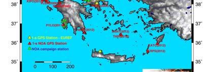
3 Infrastructure NOA GPS & GLONASS network: NOANET ( ) following the EUREF (Regional Reference Frame Sub Commission for Europe) ) Permanent Network standards d 22 stations at 1 s 24/7 12 stations co located at 1 10m with seismometers and strong motion sensors 55 benchmarks 3
4 NOA GPS & GLONASS network: ( ) Data: Type (e.g., binary, ascii, solutions - station ti velocities) Raw GPS + GLONASS observations at 1-s intervals Format: (international standard) Formats include MDB, Rinex, Compact Rinex,.zip, RTCM v3,x,.z field instrumentation: type of data transmission Internet (SYZEFXIS / VODAFONE/ leased lines from Greek Telecom OTE) Data archiving Current Data volume (Gbytes) 1292 Gbytes Data Volume Growth rate (GBytes/year) 192 Gbytes/year NOANET acquisition software: LEICA GNSS Spider Implement UNAVCO GSAC Infrastructure 4


5 NOA GPS & GLONASS network: Geodetic Equipment Campaign station Trimble Station KLOK NOA INGV Station ATAL NOA NTUANTUA Infrastructure Station NOA1 EUREF since

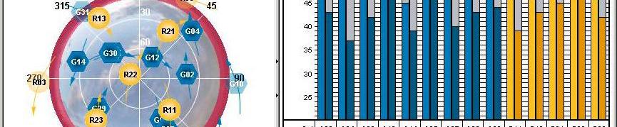
 Mean Daily aypositions o s and 1-σ deviations on")


6 1 Hz & 30 s Data Processing Analysis Processing Data analysis using the open-source software GAMIT/GLOBK software package (Version 10.4; Herring et al., 2010) Mean Daily aypositions o s and 1-σ deviations on each component Real-time PPP processing of 1-s data using IGS clocks First measurement of co-seismic deformation in Greece using GPS observations (station RLSO, June 8, 2008) Derivation of GPS velocity field that can be used for geodynamics and geophysical applications Research 6

 denote contraction while")


 Small")
7 Science: Tectonic strain using 30 s data Data input from 33 stations Principal axes of the 2-D strain rate tensor. Convergent arrows (blue) denote contraction while divergent arrows (red) denote extension. Strain rate ranges from 10 nstrain/yr up to 270 nstrain/yr. Large NNW-SSE extension is obtained across the Corinth & Sperchios rifts. Internal extension across rigid areas: a) Small rate across Attica and b) larger across northern Peloponnese. Currently analysing data from 99 stations Research 7
8 Si Science: Co seismic i offset using 30 s data Research 8
9 Science: Seismogeodesy (seismic offsets using 1 Hz data) Cephalonia earthquakes Jan & Feb 2014 GNSS seismology displacement waveforms for NOA station VLSM Science Processing by Flavio Cannavo with GIPSY 9
10 Science: Seismogeodesy (seismic offsets using 1 Hz data) Samothraki earthquake May, GNSS seismology displacement waveforms for NOA station LEMN Science Processing by Flavio Cannavo with GIPSY 10
11 Other GEO Research supported with GPS Geomorphometry using ASTER and SRTM data > assess long term uplift Fault growth relations for active faulting using field data > local networks Paleoseismology > constrain fault slip rates from geology vs GPS models Stress transfer (STROP and STROOP models incorporating fault-slip models) > constrain stress directions for optimal failure Earth Observation (thermal remote sensing for monitoring Greek volcanoes) > provide support for ground campaings (etc Santorini, 2012) Earth Observation (hyperspectral remote sensing for mineral exploration and alluvial fan differentiation) Research 11
12 Selected GPSPublications Publications Chousianitis K., Ganas A., Gianniou M., Kinematic interpretation of present-day crustal deformation in central Greece from continuous GPS measurements. Journal of Geodynamics, 71, Ganas, A., Marinou A, Anastasiou D., Paradissis D., Papazissi K., Tzavaras P., Drakatos G GPS- derived estimates of crustal deformation in the central and north Ionian Sea, Greece: 3-yr results from NOANET continuous network data. Journal of Geodynamics, 67, Ganas Athanassios, Chousianitis Kostas, Batsi Evaggelia, Kolligri Maria, Agalos Apostolos, Chouliaras Gerassimos, Makropoulos Kostas, The January 2010 Efpalion earthquakes (Gulf of Corinth, Central Greece): earthquake interactions and blind normal faulting. Journal of Seismology, 17 (2), Ganas, A., Serpelloni, E., Drakatos, G., Kolligri, M., Adamis, I., Tsimi, Ch. and Batsi, E., The Mw 6.4 SW Achaia (Western Greece) Earthquake of 8 June 2008: Seismological, Field, GPS Observations, and Stress Modeling, Journal of Earthquake Engineering, 13:8, Ganas A, Bosy J, Petro L, Drakatos G, Kontny B, Stercz M, Melis NS, Cacon S, and Kiratzi A, Monitoring active structures in eastern Corinth Gulf (Greece): The Kaparelli fault. Acta Geodynamica et Geomaterialia, 4 (1), Research 12
13 Services Open data policy (30-s data) for Solid Earth applications Network Products: Station velocities of 30-s positions at ITRF2008 reference frame (N, E, U). Implementation of the GSAC web-service of UNAVCO Use of GPS velocities to validate / calibrate InSAR PS data (TERRAFIRMA etc) Studies of active faults/subsidence for EPPO, local municipalities Provision of GNSS quality control services to the private sector 13
14 GPS/Deformation Projects & Funding ( ) P.Is Ganas, Drakatos 1. NationalFunds (Direct funding) , Euros 2. GSRT competitive funding ,00 Euros 3. EU+EEA+ESA competitive funding ,00 Euros 4. NATO (SfP) competitive funding ,00 Euros 5. Private Sector (METRICA SA, JGC) ,00 Euros 6. Services to EPPO , Euros Total funding , Euros Funding 14
15 Funding acknowledgements Data access at: Funding 15
16 2020 Visionfor Geodynamics Active Tectonics 1. Expand dthe network kto stations tti 2. Get permanent national funding for network maintenance 20kE 3. Hire qualified scientists, technicians 4. Produce tectonic strain maps on annual basis using 200+ stations 5. Operate Early Warning based on GPS: Seismogeodesy 6. Estimate coupling along the Arc 7. Measure slip rates and locking depths of active faults using block modeling 8. Expand the range of services to third parties: ground motion maps, data quality control 9. Participate to major EU ESFRI initiatives: EPOS etc Vision 16


17 Thanks for your attention! Kalochori-2 Field campaign, April
NTUA, Faculty of Rural and Surveying Engineering, Dionysos Satellite Observatory, Higher Geodesy Laboratory NOA, Institute of Geodynamics 1
 NOA, Institute of Geodynamics 1 Crustal Deformation from GPS measurements at the Ionian Sea : Preliminary Results Anastasiou 1 D., Paradissis 1 D., Ganas 2 A., Marinou 1 A., Papazissi 1 K., Drakatos 2
Realizing a geodetic reference frame using GNSS in the presence of crustal deformations: The case of Greece
 Realizing a geodetic reference frame using GNSS in the presence of crustal deformations: The case of Greece M. Gianniou National Cadastre and Mapping Agency S.A. Outline 1. Introduction 2. Deformation
Estimation of tectonic velocities using GPS Precise Point Positioning: The case of Hellenic RTK network HEPOS
 Estimation of tectonic velocities using GPS Precise Point Positioning: The case of Hellenic RTK network HEPOS M. Gianniou, I. Stavropoulou National Cadastre and Mapping Agency S.A. Mesogion Ave. 288, 15562
GEORED Project: GNSS Geodesy Network for Geodynamics Research in Colombia, South America. Héctor Mora-Páez
 GEORED Project: GNSS Geodesy Network for Geodynamics Research in Colombia, South America. Héctor Mora-Páez Colombian Geological Survey UNAVCO SCIENCE MEETING Feb 27 March 1, 2012 Boulder, CO, TECTONIC
Deformation studies in the Gulf of Patras, Western Greece
 Deformation studies in the Gulf of Patras, Western Greece K. Papazissi, D. Anastasiou, A. Marinou, C. Mitsakaki, X. Papanikolaou, D. Paradissis School of Rural & Surveying Eng., ational Technical University
GEODETIC NETWORK OF SAUDI ARABIA AND FIDUCIAL STATIONS. GFN OF Saudi Arabia in Based on ITRF2000 Datum
 STUDIES OF TECTONIC MOVEMENTS IN SAUDI ARABIA USING CORS M. Al Rajhi, Ali Al Omar, R. Yanar, F. Kartal, K. Eren, SUBJECT TO TALKS BACKGROUND GEODETIC NETWORK OF SAUDI ARABIA AND FIDUCIAL STATIONS GFN OF
GPS measurements of current crustal movements along the Gulf of Suez, Egypt.
 GPS measurements of current crustal movements along the Gulf of Suez, Egypt. Presented By Nadia Abo-Ali Assistant Researcher At National Research Institute of Astronomy and Geophysics (NRIAG), Helwan,
An analysis of the Kefalonia seismic sequence of Jan Feb. 3, 2014
 An analysis of the Kefalonia seismic sequence of Jan. 26 - Feb. 3, 2014 Alessandro Caporali 1),Carine Bruyninx 2),Rui Fernandes 3),Athanassios Ganas 4),Ambrus Kenyeres 5),Martin Lidberg 6), Guenter Stangl
Densification of the GGOS infrastructure in Poland in the framework of EPOS-PL
 EPOS European Plate Observing System Densification of the GGOS infrastructure in Poland in the framework of EPOS-PL K. Sośnica 1, J. Bosy 1, J. Kapłon 1, W. Rohm 1, T. Hadaś 1, J. Sierny 1, I. Kudłacik
Bulletin of the Geological Society of Greece
 Bulletin of the Geological Society of Greece Vol. 50, 2016 COSEISMIC DEFORMATION AND SEISMIC FAULT OF THE 17 NOVEMBER 2015 M=6.5 EARTHQUAKE, LEFKADA ISLAND Ganas Ath. Briole P. Melgar D. Bozionelos G.
The Santorini Inflation Episode, Monitored by InSAR and GPS
 The Santorini Inflation Episode, Monitored by InSAR and GPS Ioannis Papoutsis 1,2, Xanthos Papanikolaou 2, Michael Floyd 3, Kang Hyeun Ji 4, Charalampos Kontoes 1, Demitris Paradissis 2, Demitris Anastasiou
National Report of Greece to EUREF 2016
 National Report of Greece to EUREF 2016 M.Gianniou, E. Mitropoulou, D. Mastoris National Cadastre and Mapping Agency S.A. Mesogion Ave. 288, 15562 Athens, Greece 1. Introduction During the last months
Tectonic deformations in Greece and the operation of HEPOS network
 Tectonic deformations in Greece and the operation of HEPOS network M. Gianniou KTIMATOLOGIO S.A. (Hellenic Cadastre) Abstract Today, networks of permanent reference stations are broadly used for the realization
How GNSS CORS in Japan works for geodetic control and disaster mitigations
 ICG Working Group D Reference Frames, Timing and Applications How GNSS CORS in Japan works for geodetic control and disaster mitigations ICG11, Nov. 7-11, 2016, Sochi, Russia Hiromichi TSUJI Geodetic Observation
Terrafirma Extension Tectonic Theme. 6 th Terrafirma Workshop ESA-ESRIN, December 1st, 2010
 Terrafirma Extension Tectonic Theme 6 th Terrafirma Workshop ESA-ESRIN, December 1st, 2010 Summary - Service Prospectus Presentation - The Terrafirma Extension Tectonic Theme (TFX-TT) - Greek Task Force
Report for 15th PCGIAP Meeting at 18th UNRCC-AP Working Group 1 Regional Geodesy
 Report for 15th PCGIAP Meeting at 18th UNRCC-AP Working Group 1 Regional Geodesy Chairman Shigeru Matsuzaka, Japan - shigeru@gsi.go.jp Vice Chairman Prof. Pengfei Cheng, China - chengpf@casm.ac.cn John
Recent GNSS Developments and Reference Frame Issues in Turkey. Onur LENK and Bahadir AKTUĞ
 Recent GNSS Developments and Reference Frame Issues in Turkey Onur LENK and Bahadir AKTUĞ General Command of Mapping onur.lenk lenk@hgk.mil.tr 1/31 GPS STUDIES İN TURKEY date back to early 1990s geodynamics-oriented
MONITORING ACTIVE STRUCTURES IN EASTERN CORINTH GULF (GREECE): THE KAPARELLI FAULT
: THE KAPARELLI FAULT") Acta Geodyn. Geomater., Vol. 4, No. 1 (145), 1-9, 2007 MONITORING ACTIVE STRUCTURES IN EASTERN CORINTH GULF (GREECE): THE KAPARELLI FAULT Athanassios GANAS 1) *, Jaroslaw BOSY 2), Lubomir PETRO 3), George
Acta Geodyn. Geomater., Vol. 4, No. 1 (145), 1-9, 2007 MONITORING ACTIVE STRUCTURES IN EASTERN CORINTH GULF (GREECE): THE KAPARELLI FAULT Athanassios GANAS 1) *, Jaroslaw BOSY 2), Lubomir PETRO 3), George
Monitoring active structures in Eastern Corinth Gulf (Greece): the Kaparelli fault
: the Kaparelli fault") Monitoring active structures in Eastern Corinth Gulf (Greece): the Kaparelli fault Athanassios Ganas 1, Jaroslaw Bosy 2, Lubomir Petro 3, George Drakatos 1, Bernard Kontny 2, Marian Stercz 3, Nikolaos
Monitoring active structures in Eastern Corinth Gulf (Greece): the Kaparelli fault Athanassios Ganas 1, Jaroslaw Bosy 2, Lubomir Petro 3, George Drakatos 1, Bernard Kontny 2, Marian Stercz 3, Nikolaos
GEO-VIII November Geohazard Supersites and Natural Laboratories Progress Report. Document 9
 GEO-VIII 16-17 November 2011 Geohazard Supersites and Natural Laboratories Progress Report Document 9 This document is submitted to GEO-VIII for information. Geohazard Supersites and Natural Laboratories
Acta Geodyn. Geomater., Vol. 12, No. 1 (177), 5 27, 2015 DOI: /AGG journal homepage: ORIGINAL PAPER
, 5 27, 2015 DOI: /AGG journal homepage: ORIGINAL PAPER") Acta Geodyn. Geomater., Vol. 12, No. 1 (177), 5 27, 2015 DOI: 10.13168/AGG.2015.0005 journal homepage: http://www.irsm.cas.cz/acta ORIGINAL PAPER DISPLACEMENTS RECORDED ON CONTINUOUS GPS STATIONS FOLLOWING
Acta Geodyn. Geomater., Vol. 12, No. 1 (177), 5 27, 2015 DOI: 10.13168/AGG.2015.0005 journal homepage: http://www.irsm.cas.cz/acta ORIGINAL PAPER DISPLACEMENTS RECORDED ON CONTINUOUS GPS STATIONS FOLLOWING
CORS Network and Datum Harmonisation in the Asia-Pacific Region. Richard Stanaway and Craig Roberts
 CORS Network and Datum Harmonisation in the Asia-Pacific Region Richard Stanaway and Craig Roberts School of Surveying and Spatial Information Systems University of New South Wales CORS Networks in the
GEODYNAMICS AND DEFORMATIONS OF THE SUDETIC GEOLOGICAL STRUCTURAL BLOCKS
 Proceedings, 11 th FIG Symposium on Deformation Measurements, Santorini, Greece, 2003. GEODYNAMICS AND DEFORMATIONS OF THE SUDETIC GEOLOGICAL STRUCTURAL BLOCKS Vladimír Schenk 1, Zuzana Jechumálová 2,
The SSE-EU programme for Educational Seismology
 ESC2016-626-10, 2016 35th General Assembly of the European Seismological Commission Author(s) 2016. CC Attribution 3.0 License. The SSE-EU programme for Educational Seismology Gerasimos Chouliaras (1),
THREE SEASONAL BEHAVIOUR OF THE BALKAN PENINSULA GNSS PERMANENT STATIONS FROM GPS SOLUTIONS
 Доклади на Българската академия на науките Comptes rendus de l Académie bulgare des Sciences Tome 66, No 1, 2013 GEOPHYSIQUE Sismologie THREE SEASONAL BEHAVIOUR OF THE BALKAN PENINSULA GNSS PERMANENT STATIONS
The Mw 6.2 Leonidio, southern Greece earthquake of January 6, 2008: Preliminary identification of the fault plane.
 The Mw 6.2 Leonidio, southern Greece earthquake of January 6, 28: Preliminary identification of the fault plane. J. Zahradnik 1, E. Sokos 2, A.Serpetsidaki 2, and G A.Tselentis 2 1 Charles University in
The Geohazard Supersites and Natural Laboratories (GSNL).
.") The Geohazard Supersites and Natural Laboratories (GSNL). Falk Amelung, University of Miami Mike Poland, Hawaii Volcano Observatory Scott Baker, U of Miami, Unavco Outline: Overview over GSNL (Phase 2)
The Geohazard Supersites and Natural Laboratories (GSNL). Falk Amelung, University of Miami Mike Poland, Hawaii Volcano Observatory Scott Baker, U of Miami, Unavco Outline: Overview over GSNL (Phase 2)
GGSP: Realisation of the Galileo Terrestrial Reference Frame
 Galileo Geodetic Service Provider Prototype GGSP: Realisation of the Galileo Terrestrial Reference Frame Wolfgang Söhne, Johannes Ihde Federal Agency for Cartography and Geodesy Gerd Gendt, Markus Rothacher
Geodetic Department KTIMATOLOGIO S.A. (Hellenic Cadastre) K. Katsampalos, C. Kotsakis Department of Geodesy and Surveying
 K. Katsampalos, C. Kotsakis Department of Geodesy and Surveying") Realization of ETRS89 in Greece by the HEPOS network M. Gianniou i Geodetic Department KTIMATOLOGIO S.A. (Hellenic Cadastre) mgianniu@ktimatologio.gr K. Katsampalos, C. Kotsakis Department of Geodesy and
Realization of ETRS89 in Greece by the HEPOS network M. Gianniou i Geodetic Department KTIMATOLOGIO S.A. (Hellenic Cadastre) mgianniu@ktimatologio.gr K. Katsampalos, C. Kotsakis Department of Geodesy and
Low-Latency Earthquake Displacement Fields for Tsunami Early Warning and Rapid Response Support
 Low-Latency Earthquake Displacement Fields for Tsunami Early Warning and Rapid Response Support Hans-Peter Plag, Geoffrey Blewitt Nevada Bureau of Mines and Geology and Seismological Laboratory University
A comparison of existing and new methods for the analysis of nonlinear variations in coordinate time series
 IUGG 2015 - Prague, June 22 July 3, 2015 A comparison of existing and new methods for the analysis of nonlinear variations in coordinate time series Miltiadis Chatzinikos Athanasios Dermanis Department
TOWARD A JOINT CATALOGUE OF RECENT SEISMICITY IN WESTERN GREECE: PRELIMINARY RESULTS
 Δελτίο της Ελληνικής Γεωλογικής Εταιρίας τομ. XXXVII, 2007 Πρακτικά 11 ου Διεθνούς Συνεδρίου, Αθήνα, Μάιος 2007 Bulletin of the Geological Society of Greece vol. XXXVII, 2007 Proceedings of the 11 th International
CHILEAN PART OF SIRGAS REFERENCE FRAME, REALIZATION, ADOPTION, MAINTENANCE AND ACTUAL STATUS. Geodesy for Planet Earth IAG 2009, Buenos Aires
 CHILEAN PART OF SIRGAS REFERENCE FRAME, REALIZATION, ADOPTION, MAINTENANCE AND ACTUAL STATUS Geodesy for Planet Earth IAG 2009, Buenos Aires Ing. Héctor Parra hparra@igm.cl, IGM Chile Dr. Juan Báez jbaez@udec.cl,
IS THE SUDETIC MARGINAL FAULT STILL ACTIVE? RESULTS OF THE GPS MONITORING
 Acta Geodyn. Geomater.Vol.1, No.3 (135), 35-39, 2004 IS THE SUDETIC MARGINAL FAULT STILL ACTIVE? RESULTS OF THE GPS MONITORING 1996-2002 Bernard KONTNY Department of Geodesy and Photogrammetry, Agricultural
ANISOTROPY STUDY OF THE FEBRUARY 4TH 2008 SWARM IN NW PELOPONNESUS (GREECE)
") Δελτίο της Ελληνικής Γεωλογικής Εταιρίας, 2010 Πρακτικά 12 ου Διεθνούς Συνεδρίου, Πάτρα, Μάιος 2010 Bulletin of the Geological Society of Greece, 2010 Proceedings of the 12 th International Congress, Patras,
Δελτίο της Ελληνικής Γεωλογικής Εταιρίας, 2010 Πρακτικά 12 ου Διεθνούς Συνεδρίου, Πάτρα, Μάιος 2010 Bulletin of the Geological Society of Greece, 2010 Proceedings of the 12 th International Congress, Patras,
Lateral extrusion and tectonic escape in Ilan Plain of northeastern Taiwan
 Lateral extrusion and tectonic escape in Ilan Plain of northeastern Taiwan Angelier, J., Chang, T.Y., Hu, J.C., Chang, C.P., Siame, L., Lee, J.C., Deffontaines, B., Chu, H.T, Lu, C.Y., Does extrusion occur
Separating Tectonic, Magmatic, Hydrological, and Landslide Signals in GPS Measurements near Lake Tahoe, Nevada-California
 Separating Tectonic, Magmatic, Hydrological, and Landslide Signals in GPS Measurements near Lake Tahoe, Nevada-California Geoffrey Blewitt, Corné Kreemer, William C. Hammond, & Hans-Peter Plag NV Geodetic
Dealing with significant differential tectonic plate velocities within an RTK-network: The case of HEPOS
 Dealing with significant differential tectonic plate velocities within an RTK-network: The case of HEPOS M. Gianniou, E. Mitropoulou, I. Stavropoulou National Cadastre and Mapping Agency S.A. Mesogion
Case Study of Japan: Crustal deformation monitoring with GNSS and InSAR
 Technical Seminar Reference Frame in Practice, Case Study of Japan: Crustal deformation monitoring with GNSS and InSAR Basara Miyahara miyahara-b96ip@milt.go.jp Geospatial Information Authority of Japan
CSRC Director s Report
 CSRC Director s Report C S R C Yehuda Bock Scripps Orbit and Permanent Array Center (SOPAC) California Spatial Reference Center (CSRC) Scripps Institution of Oceanography La Jolla CSRC Coordinating Council
G. Chouliaras. National Observatory of Athens, Institute of Geodynamics. P.O Box 20048, Athens, Greece.
 1 Seismicity anomalies prior to the June 8 th 2008, Mw = 6.4 earthquake in Western Greece G. Chouliaras. National Observatory of Athens, Institute of Geodynamics. P.O Box 20048, 11810 Athens, Greece. E-mail:
COMBINED PSI AND DIFFERENTIAL GPS STUDY OF ZAKYNTHOS ISLAND (W. GREECE) FOR THE PERIOD
 FOR THE PERIOD") COMBINED PSI AND DIFFERENTIAL GPS STUDY OF ZAKYNTHOS ISLAND (W. GREECE) FOR THE PERIOD 1992-2012 Vassilis Sakkas (1), Fabrizio Novali (2), Spyridoula Vassilopoulou (1), Brian N. Damiata (3), Alfio Fumagalli
COMBINED PSI AND DIFFERENTIAL GPS STUDY OF ZAKYNTHOS ISLAND (W. GREECE) FOR THE PERIOD 1992-2012 Vassilis Sakkas (1), Fabrizio Novali (2), Spyridoula Vassilopoulou (1), Brian N. Damiata (3), Alfio Fumagalli
The Greek Supersite: An initiative from the most tectonically active part of Europe
 The Greek Supersite: An initiatie from the most tectonically actie part of Europe Alexandros Saaidis, PhD. Institute of Engineering Seismology and Earthquake Engineering, EPPO GEO-XIII Plenary Side Eents
Teleseismic waveform modelling of the 2008 Leonidio event
 The 6 January 2008 (Mw6.2) Leonidio (southern Greece) intermediate depth earthquake: teleseismic body wave modelling Anastasia Kiratzi and Christoforos Benetatos Department of Geophysics, Aristotle University
Slip Rates Estimate of Western North Anatolian Fault System in Turkey
 Slip Rates Estimate of Western North Anatolian Fault System in Turkey Haluk OZENER, Asli DOGRU, Bahadir AKTUG, Semih ERGINTAV, Bulent TURGUT, Onur YILMAZ, Kerem HALICIOGLU, Onur GURKAN, Turkey Keywords:
The Global Geodetic Observing System (GGOS) of the International Association of Geodesy, IAG
 of the International Association of Geodesy, IAG") The Global Geodetic Observing System (GGOS) of the International Association of Geodesy, IAG Hans-Peter Plag (1), Markus Rothacher (2), Richard Gross (3), Srinivas Bettadpur (4) (1) Nevada Bureau of Mines
The Global Geodetic Observing System (GGOS) of the International Association of Geodesy, IAG Hans-Peter Plag (1), Markus Rothacher (2), Richard Gross (3), Srinivas Bettadpur (4) (1) Nevada Bureau of Mines
The Size and Duration of the Sumatra-Andaman Earthquake from Far-Field Static Offsets
 The Size and Duration of the Sumatra-Andaman Earthquake from Far-Field Static Offsets P. Banerjee, 1 F. F. Pollitz, 2 R. Bürgmann 3 * 1 Wadia Institute of Himalayan Geology, Dehra Dun, 248001, India. 2
NCC roles in successful disaster response I.R.IRAN
 The Second UN-GGIM-AP Plenary Meeting NCC roles in successful disaster response I.R.IRAN Teheran Iran 28-30 October 2013 Ali Javidaneh Technical Deputy of National Cartographic Center (NCC) Outline Types
GG S. Internal Vision of GGOS. Markus Rothacher. GFZ Potsdam
 Internal Vision of GGOS Markus Rothacher GFZ Potsdam GGOS Retreat DGFI in Munich February 15-16, 2006 Contents Motivation Four Levels of Products of the IAG Services: First Level: Raw Data Collection Second
A new era of geodetic big data - challenges and opportunities Tim Wright (COMET, University of
 A new era of geodetic big data - challenges and opportunities Tim Wright (COMET, University of Leeds) S @NERC_COMET N A New Era of Geodetic Big Data? GEM Strain Rate Model 17,491 GNSS sites included in
SAR APPLICATIONS IN GREECE With emphasis for Harokopio University/ Dep. of Geography activities
 SAR APPLICATIONS IN GREECE With emphasis for Harokopio University/ Dep. of Geography activities Issaak Parcharidis, Assist. Prof. Harokopio University of Athens Department of Geography parchar@hua.gr 4
Operational Aspects of GNSS CORS What is a GNSS CORS system used for?
 Please insert a picture (Insert, Picture, from file). Size according to grey field (10 cm x 25.4 cm). Scale picture: highlight, pull corner point Cut picture: highlight, choose the cutting icon from the
The BIFROST Project: 21 years of search for the true crustal deformation in Fennoscandia
 The BIFROST Project: 21 years of search for the true crustal deformation in Fennoscandia Martin Lidberg and Holger Steffen Lantmäteriet, Sweden Jan Johansson Chalmers University of Technology Halfdan Kierulf
ON THE RELATION BETWEEN GPS STRAIN FIELD AND ACTIVE FAULTS IN THE EASTERN BALTIC REGION
 ON THE RELATION BETWEEN GPS STRAIN FIELD AND ACTIVE FAULTS IN THE EASTERN BALTIC REGION B.A. Assinovskaya 1, V.L. Gorshkov 2, N.V. Shcherbakova 2, N.M. Panas 1 1 Geophysical Service RAS, seismic station
Research infrastructures in FP7: Seismology and Geophysics
 Research infrastructures in FP7: Seismology and Geophysics Domenico Giardini, ETHZ Internation Workshop on Disaster Risk Reduction Bruxelles 29-30 October, 2009 EC FP7 2007-2013 Seven-year targeted program
Data base of Italian velocities and strain rates at permanent GNSS sites. A. Caporali, M. Bertocco, J. Zurutuza, University of Padova
 Data base of Italian velocities and strain rates at permanent GNSS sites A. Caporali, M. Bertocco, J. Zurutuza, University of Padova Outlook Part 1: GNSS data reduction and organization Italian permanent
ESTIMATES OF HORIZONTAL DISPLACEMENTS ASSOCIATED WITH THE 1999 TAIWAN EARTHQUAKE
 ESTIMATES OF HORIZONTAL DISPLACEMENTS ASSOCIATED WITH THE 1999 TAIWAN EARTHQUAKE C. C. Chang Department of Surveying and Mapping Engineering Chung Cheng Institute of Technology, Taiwan, ROC ABSTRACT A
Current Status of EPOS GNSS Working Group. Rui Fernandes on behalf of WG4 members
 Current Status of EPOS GNSS Working Group Rui Fernandes on behalf of 4 members 1 Current Status W G4 COM POSI TI ON Fir st N a m e Rui Luisa Carine Nicola Jan Athanassios Martin Andrzej Matthias Richard
MODERATE MAGNITUDE EARTHQUAKE SEQUENCES IN CENTRAL GREECE (FOR THE YEAR 2008) Roumelioti Z. 1, and Kiratzi A. 2. Greece,
 Roumelioti Z. 1, and Kiratzi A. 2. Greece,") ελτίο της Ελληνικής Γεωλογικής Εταιρίας, XLIII (4), 2144-2153. Bulletin of the Geological Society of Greece, vol. XLIII (4), 2144-2153. MODERATE MAGNITUDE EARTHQUAKE SEQUENCES IN CENTRAL GREECE (FOR THE
ελτίο της Ελληνικής Γεωλογικής Εταιρίας, XLIII (4), 2144-2153. Bulletin of the Geological Society of Greece, vol. XLIII (4), 2144-2153. MODERATE MAGNITUDE EARTHQUAKE SEQUENCES IN CENTRAL GREECE (FOR THE
PLEASE SCROLL DOWN FOR ARTICLE
 This article was downloaded by: [HEAL-Link Consortium] On: 20 October 2009 Access details: Access Details: [subscription number 772810551] Publisher Taylor & Francis Informa Ltd Registered in England and
A Unique Reference Frame: Basis of the Global Geodetic Observing System (GGOS) for Geodynamics and Global Change
 for Geodynamics and Global Change") SRTM (InSAR) A Unique Reference Frame: Basis of the Global Geodetic Observing System (GGOS) for Geodynamics and Global Change Hermann Drewes President IAG Commission 1 Reference Frames Deutsches Geodätisches
SRTM (InSAR) A Unique Reference Frame: Basis of the Global Geodetic Observing System (GGOS) for Geodynamics and Global Change Hermann Drewes President IAG Commission 1 Reference Frames Deutsches Geodätisches
Actual Continuous Kinematic Model (ACKIM) of the Earth s Crust based on ITRF2014
 of the Earth s Crust based on ITRF2014") Actual Continuous Kinematic Model (ACKIM) of the Earth s Crust based on ITRF2014 Hermann Drewes Technische Universität München Joint Scientific Assembly of the International Association of Geodesy and
Actual Continuous Kinematic Model (ACKIM) of the Earth s Crust based on ITRF2014 Hermann Drewes Technische Universität München Joint Scientific Assembly of the International Association of Geodesy and
Seismicity anomalies prior to 8 June 2008, M w =6.4 earthquake in Western Greece
 Nat. Hazards Earth Syst. Sci., 9, 327 335, 2009 Author(s) 2009. This work is distributed under the Creative Commons Attribution 3.0 License. Natural Hazards and Earth System Sciences Seismicity anomalies
Reference frames and positioning
 The APREF Project: an Improved Geodetic Infrastructure for Asia and the Pacific (4861) John Dawson (Australia), Graeme Blick (New Zealand), Manoj Deo, Guorong Hu and Gary Johnston (Australia) Reference
Developments towards GNSS real-time service in GFZ
 1 Developments towards GNSS real-time service in GFZ Dousa, J., Ge, M., Chen J., Gendt, G. Helmholtz-Zentrum Potsdam, Deutsches GeoForschungsZentrum Geng, J. University Institute of Engineering Surveying
Introduction to Strain and Borehole Strainmeter Data
 Introduction to Strain and Borehole Strainmeter Data Evelyn Roeloffs U. S. Geological Survey Earthquake Science Center March 28, 2016 Evelyn Roeloffs, USGS ESC Strainmeters: Introduction March 28, 2016
Yellowstone Hotspot Component of the Plate Boundary Observatory
 Yellowstone Hotspot Component of the Plate Boundary Observatory (Investigators: Smith, Thatcher, Meertens, Humphreys, Dzurisin, Oldow Co-Investigators: Christiansen, Doss, Schwartz, Machette, Wong, Olig,
COMPARISON OF COSEISMIC DISPLACEMENTS OBTAINED FROM STRONG MOTION ACCELEROGRAMS AND GPS DATA IN JAPAN
 COMPARISON OF COSEISMIC DISPLACEMENTS OBTAINED FROM STRONG MOTION ACCELEROGRAMS AND GPS DATA IN JAPAN Fumio YAMAZAKI 1, Luis MOYA 2, Kiminobu ANEKOJI 3 and Wen LIU 4 ABSTRACT Strong motion seismometers
Ground deformation in Thessaly, Central Greece, between 1992 and 2000 by means of ERS multi-temporal InSAR
 INGV Ground deformation in Thessaly, Central Greece, between 1992 and 2000 by means of ERS multi-temporal InSAR S. Atzori (1), C. Tolomei (1), S. Salvi (1), A. Ganas (2), S. Stramondo (1) and L. Colini
The January 2010 Efpalion earthquakes (Gulf of Corinth, Central Greece): earthquake interactions and blind normal faulting
: earthquake interactions and blind normal faulting") DOI 10.1007/s10950-012-9331-6 ORIGINAL ARTICLE The January 2010 Efpalion earthquakes (Gulf of Corinth, Central Greece): earthquake interactions and blind normal faulting Athanassios Ganas & Kostas Chousianitis
DOI 10.1007/s10950-012-9331-6 ORIGINAL ARTICLE The January 2010 Efpalion earthquakes (Gulf of Corinth, Central Greece): earthquake interactions and blind normal faulting Athanassios Ganas & Kostas Chousianitis
Publ. Astron. Obs. Belgrade No. 91 (2012), REALIZATION OF ETRF2000 AS A NEW TERRESTRIAL REFERENCE FRAME IN REPUBLIC OF SERBIA
, REALIZATION OF ETRF2000 AS A NEW TERRESTRIAL REFERENCE FRAME IN REPUBLIC OF SERBIA") Publ. Astron. Obs. Belgrade No. 91 (2012), 199-206 Contributed paper REALIZATION OF ETRF2000 AS A NEW TERRESTRIAL REFERENCE FRAME IN REPUBLIC OF SERBIA D. BLAGOJEVIĆ and V. VASILIĆ Faculty of Civil Engineering,
Publ. Astron. Obs. Belgrade No. 91 (2012), 199-206 Contributed paper REALIZATION OF ETRF2000 AS A NEW TERRESTRIAL REFERENCE FRAME IN REPUBLIC OF SERBIA D. BLAGOJEVIĆ and V. VASILIĆ Faculty of Civil Engineering,
The problem (1/2) GPS velocity fields in plate boundary zones are very smooth. What does this smoothness hide?
 GPS velocity fields in plate boundary zones are very smooth. What does this smoothness hide?") Block models The problem (1/2) GPS velocity fields in plate boundary zones are very smooth Figure from Tom Herring, MIT What does this smoothness hide? Continuous deformation? Rigid block motions, with
Block models The problem (1/2) GPS velocity fields in plate boundary zones are very smooth Figure from Tom Herring, MIT What does this smoothness hide? Continuous deformation? Rigid block motions, with
Electronic supplement for Forearc motion and deformation between El Salvador and Nicaragua: GPS, seismic, structural, and paleomagnetic observations
 DR2011053 Electronic supplement for Forearc motion and deformation between El Salvador and Nicaragua: GPS, seismic, structural, and paleomagnetic observations by D. Alvarado et al., Lithosphere, April,
A Strategic Plan for Geodesy in Sweden. Mikael Lilje Lars E. Engberg Geodesy Department Lantmäteriet Sweden
 A Strategic Plan for Geodesy in Sweden Mikael Lilje Lars E. Engberg Geodesy Department Lantmäteriet Sweden Our vision is to be able to meet Swedish society s needs for a homogeneous, sustainable geodetic
National report of Slovakia 2017
 National report of Slovakia 2017 Branislav Droščák, Karol Smolík, Pavol Ceizel, Ján Bublavý, Miroslav Steinhubel, et al. 1) Juraj Papčo, Ľubomíra Gerhátová, Marcel Mojzeš, Martin Imrišek, et al. 2) Katarína
Case study of Japan: Reference Frames in Practice
 Case study of Japan: Reference Frames in Practice Basara Miyahara and Koji Matsuo Sponsors: 1 Outline Introduction - Geodetic reference frame of Japan - GEONET : continuous GNSS observation system Geometric
EARTHQUAKE RELOCATION IN GREECE USING A UNIFIED AND HOMOGENIZED SEISMOLOGICAL CATALOGUE
 Δελτίο της Ελληνικής Γεωλογικής Εταιρίας, 2010 Πρακτικά 12 ου Διεθνούς Συνεδρίου, Πάτρα, Μάιος 2010 Bulletin of the Geological Society of Greece, 2010 Proceedings of the 12 th International Congress, Patras,
Do we need to update PNG94 to PNG2020?
 Do we need to update PNG94 to PNG2020? Richard Stanaway Quickclose Pty Ltd Robert Rosa PNG University of Technology, Lae Does PNG94 have a use by date? PNG94 is now 23 years old (reference epoch) Users
ECGN - Development of the European Combined Geodetic Network in Austria
 ECGN - Development of the European Combined Geodetic Network in Austria Diethard Ruess 1, Gelöscht: BEV Dept. Control Survey Abstract Austria takes part in the European Combined Geodetic Network - Project
Military Geographic Institute
 New Chilean Reference Frame, 3 years after Maule Earthquake 90 YEARS SUPORTING THE NATIONAL DEVELOPMENT Major Julio Neira Gutierrez (MSc) Head of Geodetic Department & GDB Military Geographic Institute
Warkworth geodetic station as a potential GGOS core site in New Zealand
 "Launching the Next-Generation IVS Network Session 2: Correlators, Stations and Operations Centers. 7th IVS General Meeting March 5, 2012 Madrid, Spain Warkworth geodetic station as a potential GGOS core
Combining InSAR, Levelling and GNSS for the Estimation of 3D Surface Displacements
 Combining InSAR, Levelling and GNSS for the Estimation of 3D Surface Displacements Thomas Fuhrmann (1), Miguel Caro Cuenca (2), Freek van Leijen (3), Malte Westerhaus (1), Ramon Hanssen (3), Bernhard Heck
The Continuously Operation Caribbean Observational Network: COCONet
 The Continuously Operation Caribbean Observational Network: COCONet Glen S. Mattioli University of Texas at Arlington Presenting for COCONet Executive Committee: M. Miller(1), E. Calais(2), C. Meertens(1),
The March 11, 2011, Tohoku-oki earthquake (Japan): surface displacement and source modelling
: surface displacement and source modelling") The March 11, 2011, Tohoku-oki earthquake (Japan): surface displacement and source modelling Salvatore Stramondo Bignami C., Borgstrom S., Chini M., Guglielmino F., Melini D., Puglisi G., Siniscalchi V.,
The March 11, 2011, Tohoku-oki earthquake (Japan): surface displacement and source modelling Salvatore Stramondo Bignami C., Borgstrom S., Chini M., Guglielmino F., Melini D., Puglisi G., Siniscalchi V.,
EXPLORE PLATE TECTONICS & MORE THROUGH GPS DATA. Shelley Olds, UNAVCO April 12, 2018 NGSS Webinar
 EXPLORE PLATE TECTONICS & MORE THROUGH GPS DATA Shelley Olds, UNAVCO April 12, 2018 NGSS Webinar Today s Outline Central question: How do we know the tectonic plates are still moving? -- What evidence
Semi-Dynamic Datum of Indonesia
 Technical Seminar Reference Frame in Practice, Semi-Dynamic Datum of Indonesia H.Z. Abidin, A.B. Wijanarto, S.T. Wibowo, Susilo, J. Efendi Geospatial Information Agency, Indonesia (BIG) Sponsors: Page
The PaTrop Experiment
 Improved estimation of the tropospheric delay component in GNSS and InSAR measurements in the Western Corinth Gulf (Greece), by the use of a highresolution meteorological model: The PaTrop Experiment N.
Earthquake distribution is not random: very narrow deforming zones (= plate boundaries) versus large areas with no earthquakes (= rigid plate
 versus large areas with no earthquakes (= rigid plate") Earthquake distribution is not random: very narrow deforming zones (= plate boundaries) versus large areas with no earthquakes (= rigid plate interiors) Tectonic plates and their boundaries today -- continents
Earthquake distribution is not random: very narrow deforming zones (= plate boundaries) versus large areas with no earthquakes (= rigid plate interiors) Tectonic plates and their boundaries today -- continents
GNSS measurements in Ulaanbaatar and its vicinity
 GNSS measurements in Ulaanbaatar and its vicinity Erdenezul Danzansan Institute of Astronomy and Geophysics MAS, Ulaanbaatar, Mongolia erdenezul@iag.ac.mn Andrei Miroshnichenko Institute of the Earth s
Quantitative assessment of natural and anthropogenic land subsidence in oil and gas productive areas: issues and prospects in Italy.
 Quantitative assessment of natural and anthropogenic land subsidence in oil and gas productive areas: issues and prospects in Italy Valerio Comerci All information are publicly available at: Environmental
Seismogeodesy for rapid earthquake and tsunami characterization
 Seismogeodesy for rapid earthquake and tsunami characterization Yehuda Bock Scripps Orbit and Permanent Array Center Scripps Institution of Oceanography READI & NOAA-NASA Tsunami Early Warning Projects
A ten years analysis of deformation in the Corinthian Gulf via GPS and SAR Interferometry
 A ten years analysis of deformation in the Corinthian Gulf via GPS and SAR Interferometry Briole P. (1), A. Avallone (1), E. Agatza-Balodimiou (2), H. Billiris (2), O. Charade (1), H. Lyon- Caen (1), Ch.
Seismological Study of Earthquake Swarms in South-Eastern Puerto Rico
 Seismological Study of Earthquake Swarms in South-Eastern Puerto Rico Principal Investigator: Lillian Soto-Cordero [1] Co-Investigators: Victor Huérfano 1, Leonardo Cano [2], Robert Watts [3], and Christa
Advantages of GNSS in Monitoring Crustal Deformation for Detection of Precursors to Strong Earthquakes
 Positioning, 2013, 4, 11-19 http://dx.doi.org/10.4236/pos.2013.41003 Published Online February 2013 (http://www.scirp.org/journal/pos) 11 Advantages of GNSS in Monitoring Crustal Deformation for Detection
A Deformation Model to support a Next Generation Australian Geodetic Datum
 A Deformation Model to support a Next Generation Australian Geodetic Datum Richard Stanaway, Surveying and Geospatial Engineering School of Civil and Environmental Engineering multi-gnss + augmentation
An Assessment of the Accuracy of PPP in Remote Areas in Oman
 An Assessment of the Accuracy of PPP in Remote Areas in Oman Rashid AL ALAWI, Sultanate of Oman and Audrey MARTIN, Ireland Keywords: GNSS, PPP, Oman Survey Infrastructure SUMMARY Traditionally, high accuracy
DUBAI SEISMIC NETWORK (DSN)
") DUBAI SEISMIC NETWORK (DSN) Eman Al Khatibi 1, Kamal Abou Elenean 1 1 Dubai Municipality, Survey Department, P.O. Box: 67 Dubai U.A.E. 8 th Gulf Seismic Forum, 3-6 March 2013, Muscat-Sultanate of Oman
DUBAI SEISMIC NETWORK (DSN) Eman Al Khatibi 1, Kamal Abou Elenean 1 1 Dubai Municipality, Survey Department, P.O. Box: 67 Dubai U.A.E. 8 th Gulf Seismic Forum, 3-6 March 2013, Muscat-Sultanate of Oman
Geodetic Observing Systems: tools in observing the Glacial Isostatic Adjustment. Markku Poutanen Finnish Geodetic Institute
 Geodetic Observing Systems: tools in observing the Glacial Isostatic Adjustment Markku Poutanen Finnish Geodetic Institute Glacial Isostatic Adjustment Land uplift is just one consequence of the physical
COUNTRY REPORT THE SEVENTEENTH PERMANENT COMMITTEE ON GIS INFRASTRUCTURE FOR ASIA AND THE PACIFIC (PCGIAP) MEETING JULY 21 22, 2011,
 MEETING JULY 21 22, 2011,") COUNTRY REPORT INDONESIA ACTIVITIES IN 2010 THE SEVENTEENTH PERMANENT COMMITTEE ON GIS INFRASTRUCTURE FOR ASIA AND THE PACIFIC (PCGIAP) MEETING JULY 21 22, 2011, CHINGGIS KHAAN HOTEL, ULAANBAATAR CITY,
COUNTRY REPORT INDONESIA ACTIVITIES IN 2010 THE SEVENTEENTH PERMANENT COMMITTEE ON GIS INFRASTRUCTURE FOR ASIA AND THE PACIFIC (PCGIAP) MEETING JULY 21 22, 2011, CHINGGIS KHAAN HOTEL, ULAANBAATAR CITY,
The BEYOND Center of Excellence for monitoring natural disasters from space
 The BEYOND Center of Excellence for monitoring natural disasters from space Ioannis Papoutsis National Observatory of Athens Institute for Astronomy, Astrophysics, Space Applications & Remote Sensing MOWE-IT