Quantitative assessment of natural and anthropogenic land subsidence in oil and gas productive areas: issues and prospects in Italy.
|
|
|
- Daniela Hampton
- 5 years ago
- Views:
Transcription


1 Quantitative assessment of natural and anthropogenic land subsidence in oil and gas productive areas: issues and prospects in Italy Valerio Comerci
2 All information are publicly available at:

3 Environmental Impact Assessment In Italy, a Technical Committee for Environmental Impact Assessment is appointed by decree of the Minister for the Environment and the Protection of the Territory and the Sea Since 2008, ISPRA gives support to the Technical Committee for EIA


4 Po Adriatic Sea
 with marine lithologies (sands, silts, clays).")

5 The only morphologies found in the study area correspond to ancient paleochannels and dune bars (Bondesan, 1985), and artificial river banks bordering watercourses or reclaimed areas. The stratigraphy shows the alternating and interdigitation of continental lithologies (paleochannels, dune bar) with marine lithologies (sands, silts, clays). The lithology of the dunes is predominantly sandy while the paleochannels are filled by a clay lithology Comacchio lagoon Average height between -2.5 m and -3 m Surficial stratigraphy of reclaimed land: 0-0,50 m: soil 0,50 1,60-6,00m: dark peat clay deposits, typical of fluvial-lacustrine facies, with abundant shell remains 1,60-6,00 11,50m: sandy deposits with peat levels and shell levels 11,50 16,00m: compacted silty clay 16,00 20,00m: silty sand deposits
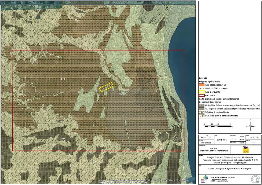
6 Agosta Lithological map

7 Well Agosta. 2,253 m deep (-1,989.7 m a.s.l.) In the first 1000 m sandy deposits with silt/clay intercalations (Asti sands - Emiliano Romagnolo Supersyntem).


8 2 layers of Pliocene Sandy formations (Porto Garibaldi and Porto Corsini) mineralized with methane gas Estimated production: 453,4 Mm3 by 2 strings. Lifetime: at least 13 years Production started in 1971 Stopped from 2004 to wells deep 2,900 3,800 m for 13 production strings Closing date: 2027

9 The two reservoir are considered hydraulically separated. Two separate fluid dynamic studies (3D Eclipse model) were performed. Geomechanical modeling using finite element method 74 layers. Bedrock is the top of carbonatic rocks deep between 4,000 and 7,500 m Mesh of the Finite element method used in the ISAMGEO elasto-plastic model for the fields of Dosso and Agosta.
10 Results of simulations: Subsidence induced by Dosso+Agosta, at Dosso and Agosta for different uniaxial compressibility Dosso started in 1971 Agosta supposed start Dosso supposed closure Agosta supposed closure Subsidence induced only by Agosta, at Agosta
11 Control points Comparison with available data The results of the simulation were compared with the measured data available for the study area. This comparison was made only with reference to the Cm Med scenario (for Agosta). The comparison between measured and computed data requires that the first is cleaned from subsidence components not attributable to gas extraction (in this case the only extraction from the Dosso field). There is uncertainty about the value of the subsidence non-attributable to gas extraction, which is itself composed by compaction and oxidation of surface sediments (rich in organic matter), any water extraction component, and a deep tectonic component. The oil Company assumed that the average subsidence component not attributable to gas extraction was, for the whole area under examination, -5 mm / year. This value was chosen on the basis of recent integrated analyzes of the various historical available measurements


 in the Ravenna Municipality over the 1897-1957")

12 Teatini et al., 2005 AGOSTA Simeoni et al., 2007 used InSAR data, calibrated with geometric levelling data, to estimate the absolute velocities in the southern border of the Valli di Comacchio ERS Asc Bitelli et al Map of the displacement rates (mm/year) obtained by PSI on ERS-1/2 ( ) images Land subsidence rate (mm/year) in the Ravenna Municipality over the period. Can be considered as a quite reliable representation of the Natural land subsidence Natural and anthropic Subsidence can be estimated about - 5 mm / year RADARSAT-1 Asc Factors that likely contribute to the observed land displacements over the period.


13 Reprocessing with SqueeSAR technique: ERS and RADARSAT, Asc + Desc ERS1-2: RADARSAT-1: RADARSAT-1:


14 Area for comparison between Oil Company and ARPA results Comparison of analyzed InSAR data by the oil Company and by ARPA for the area of Dosso degli Angeli


15 RER, ARPAE : Vertical Velocity maps Geometric levelling RER, ARPAE, : Vertical Velocity maps PSInSAR ENVISAT Asc+Desc RADARSAT-1 Asc Calibrated with geometric levelling data
 Based on SqueeSAR")

16 RER, ARPAE, 2012: vertical ground velocity map (1:250,000) Based on SqueeSAR elaboration of RADARSAT-1 Asc images, calibrated with 16 CGPS Stations (Bitelli et al., 2015)

17 62% of the territory: no variation 35% of the territory: reduction of subsidence 3% of the territory: increase of subsidence Map of variations of vertical velocities from to


18 Asc+Desc Desc Vertical velocities Asc+Desc Asc+Desc Differences from 5 to 10 mm/yr Vertical velocities Asc+Desc Asc Differences up to 10 mm/yr In some case more Vertical velocities Smarlacca CGPS Good agreement (not calibrated)


19 Calibration with the Smarlacca CGPS The Smarlacca CGPS is subject to control and certification by the University of Bologna Smarlacca CGPS mm/a The average Vertical velocity of the points falling within the radius of 150m is mm / year. In order to achieve absolute velocity, mm/year was added to the vertical velocity dataset. The average of the points falling within 150 m indicates a value of mm / year.
20 Asc Asc+Desc Vertical velocities Smarlacca CGPS mm/a Calibrated Differences up to 5 mm/yr Results for Dosso For points falling within the Dosso field, for a distance of less than 150 m radius from the Smarlacca CGPS, the average velocities are as follows: : - 8 mm/year : - 8 mm/year (calibrated with Smarlacca CGPS) : - 6 mm/year (calibrated with Smarlacca CGPS)

21 SqueeSAR elaboration of CSK data for the period


22 Calibration with Smarlacca CGPS and check with Spinaroni CGPS Smarlacca CGPS mm/yr R: 100 m


23 Calibrated velocities are quite in agreement with the velocity registered by Spinaroni CGPS SqueeSAR CSK calibrated vertical component

24 The average vertical velocity of the PS / DS at the Agosta field is about -4 mm / year


25 The average velocity is about -5.5 mm / year.
26 In the simulation of the geomechanical model, the oil company assumed that the average subsidence component not attributable to gas extraction was, for the whole area under examination, -5 mm/year The value of -5 mm/year has been subtracted from measured data in the control points (geometric levelling, GPS and InSAR), in order to obtain the part attributable to gas extraction Comparison of measured subsidence, after taking away the non-gas components (-5 mm / year), and the result of the simulation at the Smarlacca GPS station and at two leveling benchmarks Comparison of InSAR data for the five control points, after taking away the non-gas component, and result of the simulation at the same points (black line).
27 Simulation of subsidence induced by Agosta + Dosso production At Agosta 2030: 17 cm Anthropogenic cm Natural (5 mm/yr x 13 years) Simulation of subsidence induced only by Agosta production 2030: 15 cm Anthropogenic cm Natural

28 In the province of Ferrara, for more than 60% of the surface, there is a decrease in the lowering, which averages around 2 mm / year. In essence, the entire territory is free from significant land subsidence. Approaching the Po Delta, we notice a slight accentuation of the phenomenon of a few mm / year. Agosta RER, ARPAE, 2012: vertical ground velocity map of the coastal area (1:100,000)

; FOGER Foundation of quantity surveyors")
29 SqueeSAR elaboration of 16/01/ /05/2011 RadarSat-1 Ascending images 16 permanent GPS stations belonging to three different geodetic infrastructures: IGS- EUREF (3); RING-INGV (4); FOGER Foundation of quantity surveyors (10)


30 6 GPS Stations used for calibration 6 years PS/DS velocities trend is in agreement with BOLG GPS trend


31 Estimated differences between SqueeSAR data and the 6 permanent GPS stations These differences were minimized by a calibration procedure that consisted in removing a velocity component due to orbital errors The average deformation velocities of SqueeSAR data were referred to the absolute reference system of the GPS stations

32 Successively, the vertical motion velocities of additional 10 GPS stations were used as check points with respect to the calibration result. The GPS velocities were subtracted from the velocities of the PS/DS targets in the period the SAR velocity is derived from the weighted average of such points for the period considered (the weight is proportional to the coherence of the single target) the average residual is mm/yr, standard deviation 1.39 mm/yr


33 Statistical procedures have been applied in order to remove outliers with anomalous velocity Example of a group of outliers due to the anomalous movement of an infrastructure Analysis of the outliers

34 ARPAE -2 mm/yr mm/yr Oil Company

35 vertical motion velocity map Agosta Dosso SqueeSAR analysis of RADARSAT Asc images, calibrated with 16 GPS stations
36 - Different measuring techniques for different periods: geometric levelling, GPS, InSAR - Different InSAR data stacks analysed, different geometries used - Different reference benchmarks - Different GPS networks analysed, different methods of calibration A difference of 2-5 mm/yr in the estimation of subsidence not induced by gas extraction, even if small in absolute, in relation to the working life of a gas extraction plant, may be relevant. (In the best case the measurement techniques have standard deviation +/- 1.5 mm / yr. But just this inaccuracy, on a ten-year production, can cause an estimation error of the impact of several centimeters!) As regards the EIA, the decision is being prepared by the Ministry of the Environment

37 The Italian Space Economy Strategic Plan In agreement with the Space Strategy for Europe, at National level, a Space Economy Strategic Plan has been defined with the aim to specify the operative strategic lines that will enable Italy to transform the national space sector into one of the driving forces behind the country's growth. Space Economy is the value chain that, starting from the research, development and realization of the enabling space infrastructure, called "Upstream", comes to the production of "enabled" products and services, called "Downstream" (environmental monitoring services, weather forecast, etc.). Six National strategic operative lines are designed. Among them the Mirror Copernicus, the national program in support of Copernicus. National Satellite Telecommunications Program (SATCOM); National Support Program to Galileo (Mirror Galileo); National Program for the Galileo PRS Infrastructure; Copernicus Support National Program (Mirror Copernicus); SST Support Program; Space technologies and exploration development program.

 within the National Strategic Plan The signing of")

38 Through the Public-Private Partnerships, which associate the productive and industrial system with the research system and the national actors of the Space policies (ASI, CNR, ISPRA, Department of Civil Protection, Ministry of Defence, etc.), the financial availability of 1 billion euros (half public and half private) was created, for the 6 strategic lines. The Mirror Copernicus program, composed by a set of National Operational Infrastructures, is the main investment (500 M ) within the National Strategic Plan The signing of financing contracts is expected by the end of the year. In this framework, ISPRA worked on the definition of an Italian PS Journal, designed as a Mirror Copernicus Downstream service. SNPA ISPRA, in its twofold role of coordinator of the Italian National System for Environmental Protection (SNPA) and of the National Board of Regional Geological Surveys (TNSG), collected the user needs and requirements expressed by the regional authorities (Environmental Agencies and Geological Surveys), in order to design the service TNSG PS Journal Italia

, INGV (RING network), ISPRA (geodetic data),")

39 One of the needs that the service will try to answer is that of Calibration of PS-DS data. GNSS Regional public stations 860 Regional stations public + private + IGM (geodetic/geodynamic networks), INGV (RING network), ISPRA (geodetic data), INOGS (geodetic network), ASI (high precision geodetic network), etc. The Italian Space Economy Plan offers the opportunity to structure an integrated GPS network specifically dedicated to calibrating PS / DS data
Pilot service: Southern Emilia Romagna (Italy)
") Pilot service: Southern Emilia Romagna (Italy) Surface deformation service provider (PSInSAR TM ) Geodetic and optical remote sensing data integration Final user The study area The Southern Emilia-Romagna
Pilot service: Southern Emilia Romagna (Italy) Surface deformation service provider (PSInSAR TM ) Geodetic and optical remote sensing data integration Final user The study area The Southern Emilia-Romagna
Integrated geological approach to the study of coastal subsidence in Emilia-Romagna. Luisa PERINI Calabrese Lorenzo, Luciani Paolo, Severi Paolo,
 Integrated geological approach to the study of coastal subsidence in Emilia-Romagna Luisa PERINI Calabrese Lorenzo, Luciani Paolo, Severi Paolo, Subsidence hazard of Emilia-Romagna coastal plain Caputo
SUBSIDENCE MONITORING AS KEY FACTOR FOR ENVIRONMENTAL SUSTAINABILITY OF THE OIL AND GAS PROJECTS
 SUBSIDENCE MONITORING AS KEY FACTOR FOR ENVIRONMENTAL SUSTAINABILITY OF THE OIL AND GAS PROJECTS Fabio Casolini e Francesco Italiano, Eni E&P Bologna, 12 giugno 2012 www.eni.it SUBSIDENCE it is a slow
A DInSAR Investigation of the Ground Settlement Time Evolution of Ocean-Reclaimed Lands in Shanghai
 A DInSAR Investigation of the Ground Settlement Time Evolution of Ocean-Reclaimed Lands in Shanghai Dr 3 project Id. 10644 Zhao, Qing 1 ; Pepe, Antonio 2 ; Gao, Wei 1 ; Li, Xiaofeng 3,4 ; Lu, Zhong 5 ;
Retrieval of the Long Term Ground Settlement of Ocean Reclaimed Land in Shanghai with Multi Platform Time-series InSAR
 Retrieval of the Long Term Ground Settlement of Ocean Reclaimed Land in Shanghai with Multi Platform Time-series InSAR Dr 3 project Id. 10644 Zhao, Qing 1 ; Pepe, Antonio 2 ; Bonano, Manuela 2 ; Gao, Wei
Land subsidence induced by groundwater extraction in the Alto Guadalentín aquifer, SE Spain.
 Land subsidence induced by groundwater extraction in the Alto Guadalentín aquifer, SE Spain. Pablo Ezquerro, Marta Béjar-Pizarro, Gerardo Herrera, José A. Fernández Merodo, Roberto Tomás, Carolina Guardiola-Albert,
Assessing the Ground Response to Urbanization in the Fiumicino area by Combining Geological and Geotechnical Data with Satellite InSAR Data
 Assessing the Ground Response to Urbanization in the Fiumicino area by Combining Geological and Geotechnical Data with Satellite InSAR Data P. Mazzanti F. Bozzano, C. Esposito, M. Patti, A. Rocca La Missione
THE FEASIBILITY AND APPLICATION OF PSI TO DETECT A RANGE OF GROUND AND STRUCTURE MOTION PHENOMENA.
 THE FEASIBILITY AND APPLICATION OF PSI TO DETECT A RANGE OF GROUND AND STRUCTURE MOTION PHENOMENA. Rachel Holley, InSAR Surveying Consultant InSAR Surveying Team Fugro NPA Satellite Mapping Introduction
PSI analysis of ground deformations along the south-western coast of the Gulf of Gdansk (Poland)
") FRINGE 2009 WORKSHOP, Advances in the Science and Applications of SAR Interferometry 30 November 4 December 2009 ESA-ESRIN Frascati, Italy PSI analysis of ground deformations along the south-western coast
FRINGE 2009 WORKSHOP, Advances in the Science and Applications of SAR Interferometry 30 November 4 December 2009 ESA-ESRIN Frascati, Italy PSI analysis of ground deformations along the south-western coast
Objectives. to map land subsidence at a basin scale through spaceborne
 Dipartimento di Scienze della Terra www.geo.unifi.it Tele-Rilevamento Europa TRE, a POLIMI spin-off company Land subsidence mapping and monitoring through PSInSAR: examples from the Arno river basin (Italy)
CHINA-ITALY BILATERAL SYMPOSIUM ON THE COASTAL ZONE: EVOLUTION AND SAFEGUARD
 CHINA-ITALY BILATERAL SYMPOSIUM ON THE COASTAL ZONE: EVOLUTION AND SAFEGUARD 4-8 November 2007 Bologna, ITALY Editors F.Marabini, A.Galvani, M.Ciabatti Editorial Assistant M.Barazutti C.N.R. Bologna LAND
Application of satellite InSAR data for hydrocarbon reservoir monitoring
 Application of satellite InSAR data for hydrocarbon reservoir monitoring A. Tamburini, A. Belson, A. Ferretti, F. Novali TRE Milano, Italy Copyright - Tele-Rilevamento Europa - 2004 Outline SqueeSAR TM
SDI in Lombardia (Italy(
 SDI in Lombardia (Italy( Italy) Andrea Piccin European SDI Best Practice Awards 2009 - Learning from Best Practices Turin, 26th and 27th November 2009 Lombardia, in Italy, is 4 th Region for territorial
Innovative Applications of Satellite Interferometry in the Oil&Gas Industry
 Innovative Applications of Satellite Interferometry in the Oil&Gas Industry A. Ferretti (1), G. Falorni (3), F. Novali (1), F. Rocca (2), A. Rucci (2), A. Tamburini (1) (1) Tele-Rilevamento Europa - TRE
Dynamic preservation of the coastline
 Dynamic preservation of the coastline Content Introduction The Dutch coastal defence by dynamic processes Data collection Management of the sand resources Growing importance of marine sand and gravel resources
Experiences of public-private partnerships in the Euromediterranean relations and in the Po Valley, promoting a more balanced European territory
 Experiences of public-private partnerships in the Euromediterranean relations and in the Po Valley, promoting a more balanced European territory Claudio Tolomelli PolyMetrexPlus project s objectives To
Implementation of Multi-Temporal InSAR to monitor pumping induced land subsidence in Pingtung Plain, Taiwan
 Implementation of Multi-Temporal InSAR to monitor pumping induced land subsidence in Pingtung Plain, Taiwan Presenter: Oswald Advisor: Chuen-Fa Ni Date: March 09, 2017 Literature Review Pingtung Plain
Lab 7: Sedimentary Structures
 Name: Lab 7: Sedimentary Structures Sedimentary rocks account for a negligibly small fraction of Earth s mass, yet they are commonly encountered because the processes that form them are ubiquitous in the
Observation (EO) & Geomatics in Canada
 & Geomatics in Canada") Innovating to Increase the Impact of Earth Observation (EO) & Geomatics in Canada Natural Resources Canada February 25, 2014 Prashant Shukle, Director General Canada Centre for Mapping and Earth Observation
Innovating to Increase the Impact of Earth Observation (EO) & Geomatics in Canada Natural Resources Canada February 25, 2014 Prashant Shukle, Director General Canada Centre for Mapping and Earth Observation
Infrastructure monitoring using SAR interferometry
 Infrastructure monitoring using SAR interferometry Hossein Nahavandchi Roghayeh Shamshiri Norwegian University of Science and Technology (NTNU), Department of Civil and Environmental Engineering Geodesy
Sediment and Sedimentary rock
 Sediment and Sedimentary rock Sediment: An accumulation of loose mineral grains, such as boulders, pebbles, sand, silt or mud, which are not cemented together. Mechanical and chemical weathering produces
Multi-temporal archaeological and environmental prospection in Nasca (Peru) with ERS-1/2, ENVISAT and Sentinel-1A C-band SAR data
 with ERS-1/2, ENVISAT and Sentinel-1A C-band SAR data") 12-13 November 215 ESA-ESRIN, Frascati (Rome), Italy Day 1 Session: Historical Landscapes and Environmental Analysis Multi-temporal archaeological and environmental prospection in Nasca (Peru) with ERS-1/2,
12-13 November 215 ESA-ESRIN, Frascati (Rome), Italy Day 1 Session: Historical Landscapes and Environmental Analysis Multi-temporal archaeological and environmental prospection in Nasca (Peru) with ERS-1/2,
CAPABILITY OF DETECTING RAPID SUBSIDENCE WITH COSMO SKYMED AND SENTINEL-1 DATASET OVER KONYA CITY
 CAPABILITY OF DETECTING RAPID SUBSIDENCE WITH COSMO SKYMED AND SENTINEL-1 DATASET OVER KONYA CITY Fatma CANASLAN ÇOMUT (1), Aydın USTUN (2), Milan LAZECKY (3), Daniele PERISSIN (4) (1) Disaster & Emergency
Costal flood risk in Emilia-Romagna (Italy): the sea storm of February 2015
: the sea storm of February 2015") Conférence Méditerranéenne Côtière et Maritime EDITION 3, FERRARA, ITALIA (2015) Coastal and Maritime Mediterranean Conference Disponible en ligne http://www.paralia.fr Available online Costal flood risk
Conférence Méditerranéenne Côtière et Maritime EDITION 3, FERRARA, ITALIA (2015) Coastal and Maritime Mediterranean Conference Disponible en ligne http://www.paralia.fr Available online Costal flood risk
Integration of space and terrestrial techniques to study crustal deformation. Examples in northeastern Italy
 Integration of space and terrestrial techniques to study crustal deformation. Examples in northeastern Italy Susanna Zerbini Dipartimento di Fisica, University of Bologna, Italy IAG-IASPEI Joint Capacity
In-situ Volume Change Monitoring for Deep Underlay Strata with Fiber Optical Technology
 In-situ Volume Change Monitoring for Deep Underlay Strata with Fiber Optical Technology Tatsuo Kokubo a *,Kazuyoshi Takenobu a Hidefumi Ikeda b, Shoji Kunisue b, Daisuke Nohara c Keiichi Ooba d a ASANO
THE ISONZO SOČA RIVER BASIN
 relator: PhD Geologist Alberto Cisotto e-mail: alberto.cisotto@adbve.it www.adbve.it THE ISONZO SOČA RIVER BASIN Eastern Alps District (NE Italy W Slovenia) Workshop on Transboundary Water Cooperation
FUTURE MEANDER BEND MIGRATION AND FLOODPLAIN DEVELOPMENT PATTERNS NEAR RIVER MILES 241 TO 235, SACRAMENTO RIVER
 FUTURE MEANDER BEND MIGRATION AND FLOODPLAIN DEVELOPMENT PATTERNS NEAR RIVER MILES 241 TO 235, SACRAMENTO RIVER Eric W. Larsen University of California, Davis With the assistance of Evan Girvetz REPORT
Sedimentary Basins. Gerhard Einsele. Springer-Verlag Berlin Heidelberg New York London Paris Tokyo Hong Kong Barcelona Budapest
 Gerhard Einsele Sedimentary Basins Evolution, Facies, and Sediment Budget With 269 Figures Springer-Verlag Berlin Heidelberg New York London Paris Tokyo Hong Kong Barcelona Budapest Contents Part I Types
3D Geological modeling of the coastal area in Emilia-Romagna, Italy
 8 th EUREGEO 2015, June 15 th -17 th Barcelona 3D geological modeling of the coastal area of Emilia-Romagna, Italy. Calabrese et al. 3D Geological modeling of the coastal area in Emilia-Romagna, Italy
Sediment. Weathering: mechanical and chemical decomposition and disintegration of rock and minerals at the surface
 Sediment Some basic terminology Weathering: mechanical and chemical decomposition and disintegration of rock and minerals at the surface Erosion: removal of weathered rock and minerals from one place to
A COMPREHENSIVE ANALYSIS OF THE CAPABILITES AND LIMITATIONS OF PSI
 A COMPREHENSIVE ANALYSIS OF THE CAPABILITES AND LIMITATIONS OF PSI Rachel Holley, InSAR Surveying Consultant InSAR Surveying Team Fugro NPA Satellite Mapping Introduction Look at the capabilities and limitations
Terrafirma Extension Tectonic Theme. 6 th Terrafirma Workshop ESA-ESRIN, December 1st, 2010
 Terrafirma Extension Tectonic Theme 6 th Terrafirma Workshop ESA-ESRIN, December 1st, 2010 Summary - Service Prospectus Presentation - The Terrafirma Extension Tectonic Theme (TFX-TT) - Greek Task Force
Next Generation Australian Datum. Permanent Committee on Geodesy, ICSM
 Next Generation Australian Datum Permanent Committee on Geodesy, ICSM 2 Presentation: Next Generation Australian Datum Trends in the geospatial sector The Geocentric Datum of Australia 1994 (GDA94) Progress
Dr. Simon Plank. German Remote Sensing Data Center (DFD), German Aerospace Center (DLR)
, German Aerospace Center (DLR)") Pre-survey suitability analysis of the differential and persistent scatterer synthetic ti aperture radar interferometry t method for deformation monitoring of landslides Dr. Simon Plank German Remote Sensing
Pre-survey suitability analysis of the differential and persistent scatterer synthetic ti aperture radar interferometry t method for deformation monitoring of landslides Dr. Simon Plank German Remote Sensing
Sea level rise and coastal morphological changes on tropical islands New Caledonia and French Polynesia (South Pacific)
") Manuel Garcin, Marissa Yates, Goneri Le Cozannet, Patrice Walker, Vincent Donato Sea level rise and coastal morphological changes on tropical islands New Caledonia and French Polynesia (South Pacific)
Manuel Garcin, Marissa Yates, Goneri Le Cozannet, Patrice Walker, Vincent Donato Sea level rise and coastal morphological changes on tropical islands New Caledonia and French Polynesia (South Pacific)
Copernicus Today and Tomorrow GEO Week Group on Earth Observation Geneva, 16 January 2014 The Copernicus Space Infrastructure
 Copernicus Today and Tomorrow GEO Week Group on Earth Observation Geneva, 16 January 2014 The Copernicus Space Infrastructure Thomas Beer, Policy Coordinator, Copernicus Space Office, ESA-ESRIN, Frascati
PART 5 MECHANISMS OF GROUND SETTLEMENT IN GREATER NEW ORLEANS
 PART 5 MECHANISMS OF GROUND SETTLEMENT IN GREATER NEW ORLEANS Predicted water depth in New Orleans flood inundation area based on water level of 2.37 ft in Lake Ponchartrain on Sept 2, 2005. Overlay on
Continuous Risk Assessment of Structures and Plants in Areas of Ground Deformation Susceptibility by Space-based SAR/ASAR Interferometry
 CCN4 Project Continuous Risk Assessment of Structures and Plants in Areas of Ground Deformation Susceptibility by Space-based SAR/ASAR Interferometry Issaak Parcharidis*, Michael Foumelis and Penelope
Brazil Paper for the. Second Preparatory Meeting of the Proposed United Nations Committee of Experts on Global Geographic Information Management
 Brazil Paper for the Second Preparatory Meeting of the Proposed United Nations Committee of Experts on Global Geographic Information Management on Data Integration Introduction The quick development of
Ocean meets Regions conference Committee of the Regions, Brussels 21 November 2017 Cecilia Donati. Marine Monitoring.
 Implemented by C o p e r n i c u s M a r i n e S e r v i c e : a E u r o p e a n t o o l i n s u p p o r t o f P u b l i c A d m i n i s t r a t i o n f o r a s u s t a i n a b l e B l u e G r o w t h
HURRICANE SANDY LIMITED REEVALUATION REPORT UNION BEACH, NEW JERSEY DRAFT ENGINEERING APPENDIX SUB APPENDIX C SEA LEVEL RISE ANALYSIS
 HURRICANE SANDY LIMITED REEVALUATION REPORT UNION BEACH, NEW JERSEY DRAFT ENGINEERING APPENDIX SUB APPENDIX C SEA LEVEL RISE ANALYSIS Rev. 18 Feb 2015 1.0 Introduction 1.1 Guidance The Department of the
Subsidence and associated shallow faulting hazard assessment in central Mexico using InSAR and GPS.
 Subsidence and associated shallow faulting hazard assessment in central Mexico using InSAR and GPS. E. Cabral-Cano, Instituto de Geofísica, UNAM D. Solano-Rojas, Univ. of Miami-RSMAS T. Oliver-Cabrera
Sediment and sedimentary rocks Sediment
 Sediment and sedimentary rocks Sediment From sediments to sedimentary rocks (transportation, deposition, preservation and lithification) Types of sedimentary rocks (clastic, chemical and organic) Sedimentary
USING MIKE TO MODEL COASTAL CATASTROPHE RISK
 USING MIKE TO MODEL COASTAL CATASTROPHE RISK Nicola Howe, Christopher Thomas, Joss Matthewman, John Maskell* 1 SUMMARY About RMS Who are we and what do we do? How do we use MIKE in our workflow? Case study:
3D temporal evolution of displacements recorded on Mt. Etna from the 2007 to 2010 through the SISTEM method
 3D temporal evolution of displacements recorded on Mt. Etna from the 2007 to 2010 through the SISTEM method Bonforte A., Guglielmino F.,, Puglisi G. INGV Istituto Nazionale di Gofisica e vulcanologia Osservatorio
INTEGRATED COASTAL SEDIMENT MANAGEMENT AT PHYSIOGRAPHIC UNIT SCALE, AN APPLICATION IN VERSILIA LITTORAL (TUSCANY, ITALY)
") INTEGRATED COASTAL SEDIMENT MANAGEMENT AT PHYSIOGRAPHIC UNIT SCALE, AN APPLICATION IN VERSILIA LITTORAL (TUSCANY, ITALY) Damiano Scarcella (Msc) Sergio Cappucci (PhD) Andrea Taramelli (PhD) OUTLINE Sediment
INTEGRATED COASTAL SEDIMENT MANAGEMENT AT PHYSIOGRAPHIC UNIT SCALE, AN APPLICATION IN VERSILIA LITTORAL (TUSCANY, ITALY) Damiano Scarcella (Msc) Sergio Cappucci (PhD) Andrea Taramelli (PhD) OUTLINE Sediment
core mantle crust the center of the Earth the middle layer of the Earth made up of molten (melted) rock
 rock") core the center of the Earth mantle the middle layer of the Earth made up of molten (melted) rock crust the surface layer of the Earth that includes the continents and oceans 1 continental drift the theory
core the center of the Earth mantle the middle layer of the Earth made up of molten (melted) rock crust the surface layer of the Earth that includes the continents and oceans 1 continental drift the theory
EO Information Services in support of Satellite Tools for Building Flood Defence Systems in Guyana
 EO Information Services in support of Satellite Tools for Building Flood Defence Systems in Guyana F. N. Koudogbo and A. Arnaud Altamira Information J. Leen, Eurosense World Bank HQ, Washington DC Date
Mapping of marine habitats in shallow coastal areas in Denmark
 6 th Workshop Seabed Acoustics, Rostock, November 14/15, 2013 P11-1 Mapping of marine habitats in shallow coastal areas in Denmark Dr. Zyad Al-Hamdani Geological Survey of Denmark and Greenland - GEUS
Monitoring long-term ground movements and Deep Seated Gravitational
 Monitoring long-term ground movements and Deep Seated Gravitational Slope Deformations by InSAR time series: cases studies in Italy Salvatore Stramondo (1), M. Saroli (1, 2), M. Moro (1, 2), S. Atzori
Real GDP Growth to Clock 6.75 Percent this Fiscal. Economic Survey Predicts Percent Growth in
 ETEN Enlightens-Daily current capsules (Prelims Prominence) 30 th Jan 2018 Economic Survey 2017-18 Real GDP Growth to Clock 6.75 Percent this Fiscal Economic Survey Predicts 7-7.5 Percent Growth in 2018-19
The PaTrop Experiment
 Improved estimation of the tropospheric delay component in GNSS and InSAR measurements in the Western Corinth Gulf (Greece), by the use of a highresolution meteorological model: The PaTrop Experiment N.
Oil & Gas. From exploration to distribution. Week 1 V05 Origin of hydrocarbon resources part 1. Jean-Pierre Deflandre
 Oil & Gas From exploration to distribution Week 1 V05 Origin of hydrocarbon resources part 1 Jean-Pierre Deflandre W1V5 Origin of hydrocarbon resources1 p. 1 Introduction to hydrocarbon resources You will
Groundwater pumping and land subsidence in the Emilia-Romagna coastland, Italy: Modeling the past occurrence and the future trend
 WATER RESOURCES RESEARCH, VOL. 42,, doi:10.1029/2005wr004242, 2006 Groundwater pumping and land subsidence in the Emilia-Romagna coastland, Italy: Modeling the past occurrence and the future trend P. Teatini,
Landscape evolution. An Anthropic landscape is the landscape modified by humans for their activities and life
 Landforms Landscape evolution A Natural landscape is the original landscape that exists before it is acted upon by human culture. An Anthropic landscape is the landscape modified by humans for their activities
Geological information for Europe : Towards a pan-european Geological Data Infrastructure
 Geological information for Europe : Towards a pan-european Geological Data Infrastructure Integrating geoscientific information for EU competitiveness Co-funded by the European Union European societal
Effect of Unmodelled Reference Frame Motion on InSAR Deformation Estimates
 Effect of Unmodelled Reference Frame Motion on InSAR Deformation Estimates Hermann Bähr 1, Sami Samiei-Esfahany 2 and Ramon Hanssen 2 1 Karlsruhe Institute of Technology, Germany 2 Delft University of
Belfast Sea Level Rise A Briefing for Policy Makers
 Belfast Sea Level Rise A Briefing for Policy Makers Version 3, issued 16/02/17 This paper briefly sets out the relative current rate of sea level rise in Belfast, and how this increases the risk of coastal
Weathering, Erosion, Deposition, and Landscape Development
 Weathering, Erosion, Deposition, and Landscape Development I. Weathering - the breakdown of rocks into smaller particles, also called sediments, by natural processes. Weathering is further divided into
INGV. Giuseppe Pezzo. Istituto Nazionale di Geofisica e Vulcanologia, CNT, Roma. Sessione 1.1: Terremoti e le loro faglie
 Giuseppe Pezzo Istituto Nazionale di Geofisica e Vulcanologia, CNT, Roma giuseppe.pezzo@ingv.it The study of surface deformation is one of the most important topics to improve the knowledge of the deep
BLACK PLATINUM ENERGY LTD
 Black Platinum Energy Ltd ( BPE or the Company ) Announces a Material Increase in the Discovered Dara East Gas Field Resources and Upside Potential Resources in Nearby Features Dara East Assessed Gas Resource
A BRIEF INTRODUCTION TO COPERNICUS AND CAMS
 A BRIEF INTRODUCTION TO COPERNICUS AND CAMS Juan Garcés de Marcilla Director of Copernicus Services European Centre for Medium-Range Weather Forecasts Copernicus EU Copernicus EU Copernicus EU www.copernicus.eu
BCGQ Mission Statement. Acquire new geoscientific knowledge in Québec within a sustainable development perspective of our mineral resources.
 BCGQ Mission Statement Acquire new geoscientific knowledge in Québec within a sustainable development perspective of our mineral resources. Financial Resources Natural Resources Fund, Mining Heritage Section
THE ISONZO SOČA. Workshop on Transboundary Water Cooperation in Central and Western Europe. Eastern Alps District.
 relator: PhD Geologist Alberto Cisotto e-mail: alberto.cisotto@adbve.it www.adbve.it THE ISONZO SOČA RIVER BASIN Eastern Alps District (NE Italy W Slovenia) Workshop on Transboundary Water Cooperation
Soil. Soil in Our Environment
 Soil Soil in Our Environment What is soil? Or is it Dirt? Gold s father is dirt, yet it regards itself as noble. Yiddish Proverb Is it alive? Is it fragile? Formations of Soils How much time does it take
EO, Land Motion and Climate Adaptation in Mediterranean Cities June 2014, Athens
 EO, Land Motion and Climate Adaptation in Mediterranean Cities 10-11 June 2014, Athens 1 Context UN Report: Water and Cities Facts and Figures 2 Context UN Report: Water and Cities Facts and Figures 3
NATURAL SOIL DEPOSITS
 NATURAL SOIL DEPOSITS Soils are produced by weathering of rock. Weathering is the physical or chemical breakdown of rock. Physical Processes: - Unloading - Frost Action - Organism Growth - Crystal Growth
A new tool for littorals management support in Emilia-Romagna
 Direzione Generale Ambiente, Difesa del Suolo e della Costa Regional action strategies for coastal zone adaptation to climate change A new tool for littorals management support in Emilia-Romagna the Littoral
Evaluation of subsidence from DinSAR techniques using Envisat-ASAR data at Toluca Valley Basin, Mexico.
 Evaluation of subsidence from DinSAR techniques using Envisat-ASAR data at Toluca Valley Basin, Mexico. Norma Angélica Dávila Hernández 1 Delfino Madrigal Uribe 1 Xanat Antonio Némiga 1 1 Autonomous University
DOMINANT SEDIMENTS TYPE IN ROCK Loose fragments of rocks or minerals broken off of bedrock Mineral crystals that precipitate directly out of water
 LAST NAME (ALL IN CAPS): FIRST NAME: 7. SEDIMENTARY PROCESSES, ROCKS, AND ENVIRONMENTS Instructions: Refer to Laboratory 6 in your Lab Book on pages 153-186 to answer the questions in this work sheet.
VALIDATION OF THE PERMANENT SCATTERERS TECHNIQUE IN URBAN AREAS
 VALIDATION OF THE PERMANENT SCATTERERS TECHNIQUE IN URBAN AREAS Alessandro Ferretti, Claudio Prati, Fabio Rocca, Carlo Colesanti Dipartimento di Elettonica e Informazione Politecnico di Milano Piazza L.
Margarita Stancheva Hristo Stanchev & Robert Young 2. MEDCOAST JUBILEE WORKSHOP May 2015, Iberotel Sarigerme Park, Dalaman, Turkey
 Margarita Stancheva Hristo Stanchev & Robert Young 2 INTRODUCTION: Bulgarian Black Sea coast INTRODUCTION: Increasing pressure on Bulgarian coastal zone In 2011, of the 7 364 570 people that lived in Bulgaria,
DIFFERENTIAL INSAR STUDIES IN THE BOREAL FOREST ZONE IN FINLAND
 DIFFERENTIAL INSAR STUDIES IN THE BOREAL FOREST ZONE IN FINLAND Kirsi Karila (1,2), Mika Karjalainen (1), Juha Hyyppä (1) (1) Finnish Geodetic Institute, P.O. Box 15, FIN-02431 Masala, Finland, Email:
BOSNIA AND HERZEGOVINA
 Studies to support the development of sea basin cooperation in the Mediterranean, Adriatic and Ionian, and Black Sea CONTRACT NUMBER MARE/2012/07 - REF. NO 2 REPORT 1 - ANNEX 2.2 COUNTRY FICHE - ANNEX
Land subsidence due to groundwater withdrawal in Hanoi, Vietnam
 Land Subsidence (Proceedings of the Fifth International Symposium on Land Subsidence, The Hague, October 1995). 1AHS Publ. no. 234, 1995. 55 Land subsidence due to groundwater withdrawal in Hanoi, Vietnam
a national geological survey perspective François ROBIDA BRGM (French Geological Survey)
") a national geological survey perspective François ROBIDA BRGM (French Geological Survey) Pre-Conference Seminar on Socio-Economic Value of Geospatial for National and Regional Development 21 August 2017,
a national geological survey perspective François ROBIDA BRGM (French Geological Survey) Pre-Conference Seminar on Socio-Economic Value of Geospatial for National and Regional Development 21 August 2017,
Evolution of the Po Delta, Italy
 Evolution of the Po Delta, Italy Albert Kettner & James Syvitski, Charles Vörösmarty Dynamics and Vulnerability of River Delta Systems workshop September, 2007 Outline 21,000 years ago Effects of the ever
Aggregate planning in Emilia-Romagna Region methods and data
 Aggregate planning in Emilia-Romagna Region methods and data Stakeholder consultation, SNAP-SEE project Zagreb (HR), 25 th October 2013 Christian Marasmi, Massimo Romagnoli, Anna Rita Rizzati Emilia-Romagna
Yev Kontar. Illinois State Geological Survey, University of Illinois at Urbana-Champaign
 Addressing Caribbean Geophysical Hazards through the Continuously Operating Caribbean GPS Observational Network (COCONet) and International Ocean Drilling Program (IODP) Yev Kontar Illinois State Geological
Terrafirma monitoring and mapping landslide services for Europe based on InSAR satellite data
 Department of Earth Sciences CENTRE OF COMPETENCE OF THE CIVIL PROTECTION DEPARTMENT PRESIDENCY OF THE COUNCIL OF MINISTERS Terrafirma monitoring and mapping landslide services for Europe based on InSAR
Country Report On Sdi Activities In Singapore ( )
") UNITED NATIONS E/CONF.102/IP.4 ECONOMIC AND SOCIAL COUNCIL Nineteenth United Nations Regional Cartographic Conference for Asia and the Pacific Bangkok, 29 October 1 November 2012 Item 6(b) of the provisional
UNITED NATIONS E/CONF.102/IP.4 ECONOMIC AND SOCIAL COUNCIL Nineteenth United Nations Regional Cartographic Conference for Asia and the Pacific Bangkok, 29 October 1 November 2012 Item 6(b) of the provisional
SOIL MECHANICS Geology
 14.330 SOIL MECHANICS FUNDAMENTALS OF ENGINEERING (FE) EXAM CALCULATOR POLICY (AS OF 01/23/13) http://ncees.org/exams/calculator-policy/ Casio: All fx-115 models. Examples of acceptable Casio fx-115 models
mountain rivers fixed channel boundaries (bedrock banks and bed) high transport capacity low storage input output
 high transport capacity low storage input output") mountain rivers fixed channel boundaries (bedrock banks and bed) high transport capacity low storage input output strong interaction between streams & hillslopes Sediment Budgets for Mountain Rivers Little
mountain rivers fixed channel boundaries (bedrock banks and bed) high transport capacity low storage input output strong interaction between streams & hillslopes Sediment Budgets for Mountain Rivers Little
Sedimentation Patterns in the Ganges- Brahmaputra Delta System
 Sedimentation Patterns in the Ganges- Brahmaputra Delta System SRTM-topography >10 m Irina Overeem, CSDMS, University of Colorado at Boulder K. Rogers, S. Goodbred, S. Higgins, K. Matin, Z. Kahn, S. Cohen,
Country Fiche Lithuania
 Country Fiche Lithuania Updated June 2018 1. General information The Lithuanian maritime space is delimited by the Decree of the Government of the Republic of Lithuania of 6 December, 2004, No. 1597 and
Term Knowledge Using and applying Grade Criteria Autumn 1 Assessment window October Natural hazards pose major risks to people and property.
 Assessment Schedule Year 9 2015/6 Term Knowledge Using and applying Grade Criteria Autumn 1 Assessment window October 2015 3.1.1.2 Tectonic Natural hazards pose major risks to people and property. Definition
Tectonic deformations in Greece and the operation of HEPOS network
 Tectonic deformations in Greece and the operation of HEPOS network M. Gianniou KTIMATOLOGIO S.A. (Hellenic Cadastre) Abstract Today, networks of permanent reference stations are broadly used for the realization
10/27/2014. Surface Processes. Surface Processes. Surface Processes. Surface Processes. Surface Processes
 Hewitt/Lyons/Suchocki/Yeh Conceptual Integrated Science Chapter 25 Surface or surficial processes originate at Earth's surface and reshape its contours. Surface processes include: Weathering Erosion Deposition
STUDIES OF DISPLACEMENTS OF GPS STATIONS ON POLISH COPPER BASIN AREA Alojzy Wasilewski 1, Zofia Rzepecka 1, Stanislaw Oszczak 2
 STUDIES OF DISPLACEMENTS OF GPS STATIONS ON POLISH COPPER BASIN AREA Alojzy Wasilewski 1, Zofia Rzepecka 1, Stanislaw Oszczak 2 1 Institute of Geodesy Warmia and Masuria University in Olsztyn Fax: ++48
Sedimentary Rocks. Rocks made of bits & pieces of other rocks.
 Sedimentary Rocks Rocks made of bits & pieces of other rocks. Sedimentary Rocks Igneous rocks are the most common rocks on Earth, but because most of them exist below the surface you might not have seen
MODELS TO PREDICT PERSISTENT SCATTERERS DATA DISTRIBUTION AND THEIR CAPACITY TO REGISTER MOVEMENT ALONG THE SLOPE
 MODELS TO PREDICT PERSISTENT SCATTERERS DATA DISTRIBUTION AND THEIR CAPACITY TO REGISTER MOVEMENT ALONG THE SLOPE Notti D., (1) Meisina C. (1), Zucca F. (1) and Colombo A. (2) (1) Dip. Di Scienze della
Michael Walsworth, Ryan Sullivan, Simi Odueyungbo, William Budd
 Michael Walsworth, Ryan Sullivan, Simi Odueyungbo, William Budd Estuarine Environment At first (Pritchard, 1967), an estuary was defined by the salinity of the water. Then by Clifton (1982) as an inlet
Country Report on SDI Activities in Singapore *
 UNITED NATIONS E/CONF.100/CRP.9 ECONOMIC AND SOCIAL COUNCIL Eighteenth United Nations Regional Cartographic Conference for Asia and the Pacific Bangkok, 26-29 October 2009 Item 7(a) of the provisional
CET Discovery Day. Mulga Rock Project The Ambassador, Emperor and Shogun discoveries. 24 February Xavier Moreau GM Geology & Exploration
 CET Discovery Day Mulga Rock Project The Ambassador, Emperor and Shogun discoveries 24 February 2015 Xavier Moreau GM Geology & Exploration Mulga Rock Uranium Project Presentation Outline: 1. Context behind
CPO Science Middle School Earth Science Learning System Correlated to Ohio Science Academic Content Standards for Earth Science, grades 6-8
 CPO Science Middle School Earth Science Learning System Correlated to Ohio Science Academic Content Standards for Earth Science, grades 6-8 Earth and Space Science Benchmark A - Describe how the positions
PALEOGEOGRAPHY of NYS. Definitions GEOLOGIC PROCESSES. Faulting. Folding 9/6/2012. TOPOGRAPHIC RELIEF MAP of NYS GRADATIONAL TECTONIC
 TOPOGRAPHIC RELIEF MAP of NYS PALEOGEOGRAPHY of NYS Prof. Anthony Grande AFG 2012 Definitions GEOLOGIC PROCESSES Geography: study of people living on the surface of the earth. Geology: the scientific study
Case study of Japan: Reference Frames in Practice
 Case study of Japan: Reference Frames in Practice Basara Miyahara and Koji Matsuo Sponsors: 1 Outline Introduction - Geodetic reference frame of Japan - GEONET : continuous GNSS observation system Geometric
German-Peruvian Workshop on Research Cooperation on Raw Materials of Strategic Economic Importance
 German-Peruvian Workshop on Research Cooperation on Raw Materials of Strategic Economic Importance Friday, 25 of September 2015 Sonesta Hotel El Olivar Research activities in the field of economical strategic
Statement. H.E Dr. Richard Nduhuura Permanent Representative of the Republic of Uganda to the United Nations New York
 Page1 UGANDA Permanent Mission of Uganda To the United Nations New York Tel : (212) 949 0110 Fax : (212) 687-4517 Statement By H.E Dr. Richard Nduhuura Permanent Representative of the Republic of Uganda