Assessing the Ground Response to Urbanization in the Fiumicino area by Combining Geological and Geotechnical Data with Satellite InSAR Data
|
|
|
- Amber Brooks
- 5 years ago
- Views:
Transcription


1 Assessing the Ground Response to Urbanization in the Fiumicino area by Combining Geological and Geotechnical Data with Satellite InSAR Data P. Mazzanti F. Bozzano, C. Esposito, M. Patti, A. Rocca La Missione COSMO-SkyMed: Stato dell Arte, Applicazioni e Prospettive Future Roma, Agenzia Spaziale Italiana,


2 Project objective Assessing the role of loading in order to define a predictive model of subsidence in delta plains characterized by the presence of compressible layers


3 Study Area: Tiber river delta plain Study area Leonardo Da Vinci Fiumicino Airport


4 Geological Conditions Evolution of the Tiber river delta plain from 15,000 years BP to the present... From Milli et al, 2013
 pleistocene pyroclastites; f) travertins; g) clay, sandy clay, sands; lens of gravels with malacofauna; h) gravel and sandy gravel; i) inner delta limit; l) ancient rclaimed ponds;")
5 Geological Conditions Evolution of the Tiber river delta plain from 15,000 years BP to the present led to a) Recent alluvial; b) recent dune and inetrdune sediments; c) ancient alluvial sediments; d) ancient dunes; e) pleistocene pyroclastites; f) travertins; g) clay, sandy clay, sands; lens of gravels with malacofauna; h) gravel and sandy gravel; i) inner delta limit; l) ancient rclaimed ponds; m) old channels. (Bellotti et al., 1989). Very complex geological conditions...
6 Geological Conditions Evolution of the Tiber river delta plain from 15,000 years BP to the present led to From Milli et al, 2013 Very complex geological conditions with strong lateral variations!

7 Detailed Geological Model Based on more than 480 stratigraphic borehole logs... Legend Localization of boreholes


8 Detailed Geological Model Based on more than 480 stratigraphic borehole logs..collected from: Bibliography Municipalities Fiumicino Airport technical office National Roads Department Local companies Freelancers Analyzed together in order to achieve a homogeneous interpretation!
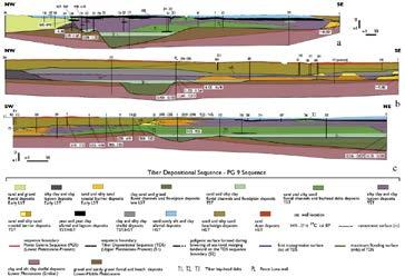
9 From the Geological Model to the Lithological Model to the Geotechnical Model Identification of the sedimentary terms involved in the subsidence process (compressible soils) Lithostratigraphic units (Milli et al., 2013) "sand, sandy silt and clay alluvial deposits" (HST) Mainly cohesive sediments Mainly non-cohesive sediments "peat and peat clay alluvial and lagoon deposits" (TST/HST) "clay and silty clay shelfal deposits" (TST/HST) "silty clay and clay lagoon deposits" (TST) "sand dune deposits" (HST) "sand and silty sand beachridge deposits" (HST) "sand and silty sand coastal barrier deposits" (TST)
10 From the Geological Model to the Lithological Model to the Geotechnical Model Identification of the sedimentary terms involved in the subsidence process (compressible soils) Mainly cohesive sediments Mainly non-cohesive sediments Lithostratigraphic units (Milli et al., 2013) "sand, sandy silt and clay alluvial deposits" (HST) "peat and peat clay alluvial and lagoon deposits" (TST/HST) "clay and silty clay shelfal deposits" (TST/HST) "silty clay and clay lagoon deposits" (TST) "sand dune deposits" (HST) "sand and silty sand beachridge deposits" (HST) "sand and silty sand coastal barrier deposits" (TST) Lithological unit lf 7 - "alluvial clayey silt" lf 6 - clayey peat" lf 2 - "silty clay and clay lagoon deposits" lf 8 - beachridge silty sands Different sedimentary terms with similar geotechnical behaviour have been grouped.
 COSMO-SkyMed")
11 A-DInSAR analyses ERS ( ) Envisat ( ) COSMO-SkyMed ( )

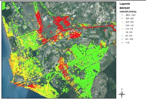
12 Geological map vs A-DInSAR results Ponds (still not reclaimed in 1884) Large scale correlation in space If we look at a large scale, there is a good spatial correlation between InSAR results and geological conditions Historical geological map (from Amenduni, 1884)
 mm/yr Historical geological map (from Amenduni,")
13 Geological map vs A-DInSAR results Ponds (still not reclaimed in 1884) Large scale correlation in space If we look at a large scale, there is a good spatial correlation between InSAR results and geological conditions Legend Envisat (vel) mm/yr Historical geological map (from Amenduni, 1884)

14 Geological map vs A-DInSAR results (Cosmo-SkyMed)

15 A-DInSAR analyses

16 A-DInSAR analyses

17 Combination of geological/geotechnical model with A-DInSAR results Geological model A-DInSAR Legend Envisat (vel) mm/yr Legend Localization of boreholes + Bad correlation! why?

18 Training sites 10 areas characterised by a detailed geological model. One inner and one outer the delta plain

; Age of buildings: the evolution of the")

19 Combination of geological/geotechnical model with A-DInSAR results in the training area In the 10 areas under investigation it seems clear the relationship between the thickness of the compressible deposits and the velocity of the measuring points. CAUSES: Typology of foundations (shallow, deep); Age of buildings: the evolution of the settlement process is strongly time-dependent (especially for such soils); Strong geological lateral variability, i.e. we cannot neglect the depth of strata responsible of the settlement process (Boussinesq theory). mm years


20 Age of buildings Increasing urbanization in the area, in the last decades. The area has been investigated by supervised classification of satellite optical data. Refinement of main areas by using multitemporal data: Typology of data Year Colour Orthophotos 2011 Colour Orthophotos :5.000 Map 2002 Colour Orthophotos 1998 B/W Orthophotos 1996 B/W Orthophotos : Map : Map Legend Age of building before


21 Effective Thickness of compressible soils The information of depth of compressible layers has been included in the conceptual model, also taking into account the thickness For every layer, starting from information achieved by stratigraphic log, an effective value of Thickness (Sp*) has been calculated, taking into account the depth and the presence of backfill layers above (considered indeed as load ).
; Different")
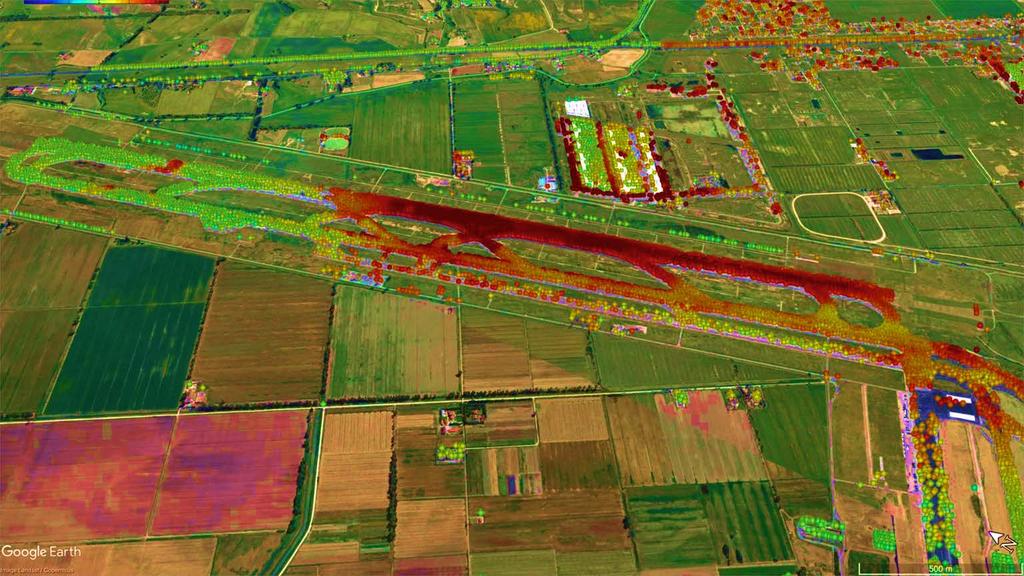
22 Now seems to work! Area 9 (Airstrip) northern sector. Envisat data Same age (last substantial works); Different geological conditions;
;")


23 Same age (last substantial works); Different geological conditions; Now seems to work! Cosmo-Skymed Modified from Manassero & Dominijanni, 2010 Torba

 and Ponte Galeria Hills (sandy and OC soils) Same age")
24 Now seems to work! The high resolution data highlights the lithological transition between Inner Delta Plain (compressible and soft soils) and Ponte Galeria Hills (sandy and OC soils) Same age (last substantial works); Different geological conditions;


 x")
25 Now seems to work! Area 10 Central area Different age. Similar geological conditions. Vel (mm/yr) x Envisat data

26 Now seems to work! Area 10 Central area Similar age Similar geological conditions; Different foundations! Vel (mm/yr) x Envisat data


27 Now seems to work! Deep foundations Shallow foundations Similar age Similar geological conditions; Different foundations!

 0-10 -20-30 -40-50 -60 15-30 years Age 15-30 years Expected settlement")
28 Testing the predictive model on COSMO-SkyMed data Some examples: 0-5 years Age 0-5 years Expected settlement = 7 cm Measured settlement 6 cm Cum. displ. (mm) years Age years Expected settlement = 3 cm Measured settlement = 3 cm Cum. Displ. (mm)
29 Looking for a generalized prediction model! By combining the subsurface geology (in terms of effective thickness (Sp*) of lithological units and related geotechnical features), the load emplacement times (t) and the surface settlement rates (V), a model able to predict the evolution of the subsidence was developed. Specific coefficients were achieved for each lithological unit (β), thus allowing to predict the subsidence rate over time caused by a new load to the surface.


30 Predicted subsidence 5 years 10 years 15 years 20 years


31 Predicted subsidence 30 years 40 years 50 years 60 years
32 CONCLUSIONS Unfortunately for A-DInSAR technology geology and geotechnics is a very complex matter very often out of schemes.fortunately for geologists and geotechnical engineers A-DInSAR exists and through the use of high resolution data like Cosmo Sky- Med geological processes can be better understood and predicted!
33
Integrated geological approach to the study of coastal subsidence in Emilia-Romagna. Luisa PERINI Calabrese Lorenzo, Luciani Paolo, Severi Paolo,
 Integrated geological approach to the study of coastal subsidence in Emilia-Romagna Luisa PERINI Calabrese Lorenzo, Luciani Paolo, Severi Paolo, Subsidence hazard of Emilia-Romagna coastal plain Caputo
Land subsidence induced by groundwater extraction in the Alto Guadalentín aquifer, SE Spain.
 Land subsidence induced by groundwater extraction in the Alto Guadalentín aquifer, SE Spain. Pablo Ezquerro, Marta Béjar-Pizarro, Gerardo Herrera, José A. Fernández Merodo, Roberto Tomás, Carolina Guardiola-Albert,
Quantitative assessment of natural and anthropogenic land subsidence in oil and gas productive areas: issues and prospects in Italy.
 Quantitative assessment of natural and anthropogenic land subsidence in oil and gas productive areas: issues and prospects in Italy Valerio Comerci All information are publicly available at: Environmental
(C) Global Journal of Engineering Science and Research Management
 Global Journal of Engineering Science and Research Management") GEOTECHNCIAL ASSESSMENT OF PART OF PORT HARCOURT, NIGER DELTA FOR STRUCTURAL ANALYSIS Warmate Tamunonengiyeofori Geostrat International Services Limited, www.geostratinternational.com. *Correspondence
GEOTECHNCIAL ASSESSMENT OF PART OF PORT HARCOURT, NIGER DELTA FOR STRUCTURAL ANALYSIS Warmate Tamunonengiyeofori Geostrat International Services Limited, www.geostratinternational.com. *Correspondence
GNS Science, Lower Hutt, New Zealand NZSEE Conference
 A Ground Shaking Amplification Map for New Zealand U. Destegul, G. Dellow & D. Heron GNS Science, Lower Hutt, New Zealand. 2008 NZSEE Conference ABSTRACT: A ground shaking amplification map of New Zealand
Geotechnical Indications Of Eastern Bypass Area In Port Harcourt, Niger Delta
 Geotechnical Indications Of Eastern Bypass Area In Port Harcourt, Niger Delta Warmate Tamunonengiyeofori Geostrat International Services Limited, Rivers State, Nigeria www.geostratinternational.com info@geostratinternational.com,
Objectives. to map land subsidence at a basin scale through spaceborne
 Dipartimento di Scienze della Terra www.geo.unifi.it Tele-Rilevamento Europa TRE, a POLIMI spin-off company Land subsidence mapping and monitoring through PSInSAR: examples from the Arno river basin (Italy)
3.4 Typical Soil Profiles
 SEI.UoC.0002.11 Figure 4. Streams in central Christchurch as mapped in March 1850, superposed on aerial photography captured on 24 February 2011. Streams digitised from the Black Map of Christchurch (March
3D Geological modeling of the coastal area in Emilia-Romagna, Italy
 8 th EUREGEO 2015, June 15 th -17 th Barcelona 3D geological modeling of the coastal area of Emilia-Romagna, Italy. Calabrese et al. 3D Geological modeling of the coastal area in Emilia-Romagna, Italy
Effect of multicyclic compaction on cohesion in lateritic soils
 Available online at www.scholarsresearchlibrary.com Scholars Research Library Archives of Applied Science Research, 2011, 3 (3):115-121 (http://scholarsresearchlibrary.com/archive.html) ISSN 0975-8X CODEN
Land subsidence due to groundwater withdrawal in Hanoi, Vietnam
 Land Subsidence (Proceedings of the Fifth International Symposium on Land Subsidence, The Hague, October 1995). 1AHS Publ. no. 234, 1995. 55 Land subsidence due to groundwater withdrawal in Hanoi, Vietnam
INVESTIGATING AND UNDERSTANDING THE GROUND WHY BOTHER?
 INVESTIGATING AND UNDERSTANDING THE GROUND WHY BOTHER? Dr Jacqueline Skipper Geotechnical Consulting Group WHAT IS UNDERSTANDING THE GROUND? Site Good enough ground model for successful project construction
URBAN HYDROLOGY: WATER IN THE CITY OF TSHWANE Plant Sciences Auditorium, University of Pretoria January 2014 URBAN HYDROGEOLOGY
 URBAN HYDROLOGY: WATER IN THE CITY OF TSHWANE Plant Sciences Auditorium, University of Pretoria 23 24 January 2014 URBAN HYDROGEOLOGY MATTHYS A. DIPPENAAR DEPARTMENT GEOLOGY, UNIVERSITY OF PRETORIA HYDROGEOLOGY
Geotechnical Engineering I CE 341
 Geotechnical Engineering I CE 341 What do we learn in this course? Introduction to Geotechnical Engineering (1) Formation, Soil Composition, Type and Identification of Soils (2) Soil Structure and Fabric
RESISTIVITY IMAGING AND BOREHOLE INVESTIGATION OF THE BANTING AREA AQUIFER, SELANGOR, MALAYSIA. A.N. Ibrahim Z.Z.T. Harith M.N.M.
 JOURNAL OF ENVIRONMENTAL HYDROLOGY The Electronic Journal of the International Association for Environmental Hydrology On the World Wide Web at http://www.hydroweb.com VOLUME 11 2003 RESISTIVITY IMAGING
COASTAL QUATERNARY GEOLOGY MAPPING FOR NSW: EXAMPLES AND APPLICATIONS
 COASTAL QUATERNARY GEOLOGY MAPPING FOR NSW: EXAMPLES AND APPLICATIONS A Troedson Geological Survey of New South Wales Abstract Detailed geological mapping of the coastal plains of regional NSW was undertaken
IAEA SAFETY STANDARDS Geotechnical Aspects of Site Evaluation and Foundations in NPPs, NS-G-3.6
 IAEA SAFETY STANDARDS Geotechnical Aspects of Site Evaluation and Foundations in NPPs, NS-G-3.6 Regional Workshop on Volcanic, Seismic, and Tsunami Hazard Assessment Related to NPP Siting Activities and
Environmental Sequence Stratigraphy: A Focus on Geology for Improved Remediation Decision Making
 Environmental Sequence Stratigraphy: A Focus on Geology for Improved Remediation Decision Making Rick Cramer, PG (Burns and McDonnell); Mike Shultz (AECOM); Colin Plank (AECOM); Herb Levine (US EPA, Region
Soil type identification and fines content estimation using the Screw Driving Sounding (SDS) data
 data") Mirjafari, S.Y. & Orense, R.P. & Suemasa, N. () Proc. th NZGS Geotechnical Symposium. Eds. GJ Alexander & CY Chin, Napier Soil type identification and fines content estimation using the Screw Driving Sounding
Mirjafari, S.Y. & Orense, R.P. & Suemasa, N. () Proc. th NZGS Geotechnical Symposium. Eds. GJ Alexander & CY Chin, Napier Soil type identification and fines content estimation using the Screw Driving Sounding
SITE INVESTIGATION STRATEGY (SIS) FOR NORISC. Checklist (ver 2.0)
 FOR NORISC. Checklist (ver 2.0)") FOR NORISC Checklist (ver 2.0) Ulf Qvarfort*, Gerhard Schwarz* and the NORISC group *) Geological Survey of Sweden Contents Pre-Investigation Phase: Site characterisation and target definition Investigation
FOR NORISC Checklist (ver 2.0) Ulf Qvarfort*, Gerhard Schwarz* and the NORISC group *) Geological Survey of Sweden Contents Pre-Investigation Phase: Site characterisation and target definition Investigation
Chapter 12 Subsurface Exploration
 Page 12 1 Chapter 12 Subsurface Exploration 1. The process of identifying the layers of deposits that underlie a proposed structure and their physical characteristics is generally referred to as (a) subsurface
Geological Mapping using Geophysics
 Geological Mapping using Geophysics Pugin, A.J.M. and T.H. Larson Illinois State Geological Survey, 615 E Peabody Dr., Champaign, IL 61820; E-mail: A.J.M. Pugin at pugin@isgs.uiuc.edu Mapping Techniques.
EXTENSION OF A HOTEL IN POIANA BRASOV ON AN INCLINED SLOPE
 Bulletin of the Transilvania University of Braşov Vol. 9 (58) - 2016 Series I: Engineering Sciences EXTENSION OF A HOTEL IN POIANA BRASOV ON AN INCLINED SLOPE M. MĂNTULESCU 1 I. TUNS 2 Abstract: Extension
Site 3: Park Road, Katikati: field logs, stratigraphic description, and site description
 Appendix 4.2 Site 3: Park Road, Katikati: field logs, stratigraphic description, and site description Criteria suitability The third site selected was at Park Road Reserve, Katikati (Figure 1). This site
Comparison of CPT Based Liquefaction Potential and Shear Wave Velocity Maps by Using 3-Dimensional GIS
 Comparison of CPT Based Liquefaction Potential and Shear Wave Velocity Maps by Using 3-Dimensional GIS Muammer Tün, Uğur Avdan, Metin Altan, Can Ayday Anadolu University, Satellite and Space Sciences Research
14 Geotechnical Hazards
 Volume 2: Assessment of Environmental Effects 296 14 Geotechnical Hazards Overview This Chapter provides an assessment of the underlying geotechnical conditions to identify: any potential liquefaction
PART 4 GEOLOGIC SETTING AND FOUNDATION CONDITIONS IN NEW ORLEANS
 PART 4 GEOLOGIC SETTING AND FOUNDATION CONDITIONS IN NEW ORLEANS The modern Mississippi Delta has been deposited during the past 6000 years, in four major areas. Current interpretation of the modern delta.
DATA REPORT GEOTECHNICAL INVESTIGATION GALVESTON CRUISE TERMINAL 2 GALVESTON, TEXAS
 DATA REPORT GEOTECHNICAL INVESTIGATION GALVESTON CRUISE TERMINAL 2 GALVESTON, TEXAS SUBMITTED TO PORT OF GALVESTON 123 ROSENBERG AVENUE, 8TH FLOOR GALVESTON, TEXAS 77553 BY HVJ ASSOCIATES, INC. HOUSTON,
CHAPTER 1 INTRODUCTION
 1 CHAPTER 1 INTRODUCTION 1.1 GENERAL Washover sandsheets are often found in low-lying coastal embayment s (Sedgwick and Davis 2003). Washover deposition of marine sand is usually attributed to storm activity
Foundations on Deep Alluvial Soils
 Canterbury Earthquakes Royal Commission Hearings 25 October 2011, Christchurch GEO.CUB.0001.1-35.1 Foundations on Deep Alluvial Soils Misko Cubrinovski, Ian McCahon, Civil and Natural Resources Engineering,
SOIL AND AGGREGATE FUNDAMENTALS STUDENT GUIDE AMRC April, 2006 AREA MANAGER ROADS CERTIFICATION PROGRAM FOR EDUCATIONAL PURPOSES ONLY
 AREA MANAGER ROADS CERTIFICATION PROGRAM AMRC 2011 SOIL AND AGGREGATE FUNDAMENTALS STUDENT GUIDE FOR EDUCATIONAL PURPOSES ONLY April, 2006 WPC #28013 07/09 2009 by British Columbia Institute of Technology
APPLICATION OF ELECTRICAL RESISTIVITY TOMOGRAPHY FOR SAND UNDERWATER EXTRACTION
 International Scientific Conference GEOBALCANICA 2018 APPLICATION OF ELECTRICAL RESISTIVITY TOMOGRAPHY FOR SAND UNDERWATER EXTRACTION Maya Grigorova Ivaylo Koprev University of Mining and Geology St. Ivan
GROUND RESPONSE ANALYSIS FOR SEISMIC DESIGN IN FRASER RIVER DELTA, BRITISH COLUMBIA
 13 th World Conference on Earthquake Engineering Vancouver, B.C., Canada August 1-6, 2004 Paper No. 2104 GROUND RESPONSE ANALYSIS FOR SEISMIC DESIGN IN FRASER RIVER DELTA, BRITISH COLUMBIA Uthaya M. UTHAYAKUMAR
Understanding Earth Fifth Edition
 Understanding Earth Fifth Edition Grotzinger Jordan Press Siever Chapter 5: SEDIMENTATION: Rocks Formed by Surface Processes Lecturer: H Mohammadzadeh Assistant professors, Department of Geology, FUM Copyright
The attitude he maintains in his relation to the engineer is very well stated in his own words:
 Su bsurface Soil Exploration, 53: 139 Foundation Engineering Geotechnical companies that have a history of experience in a given region usually have extensive boring logs and maps telling where the borings
Global Journal of Engineering Science and Research Management
 GEOTECHNICAL STUDY OF BAGHDAD SOIL Hussein H. Karim*, Safaa J. Wadaa * Professor, Building and Construction Engineering Department, University of Technology, Baghdad- Iraq M.Sc. in Geotechnical Engineering,
Castaldo R. (1) De Novellis V. (1) Lollino P. (2) Manunta M. (1) Tizzani P. (1) 1: IREA-CNR, Napoli, Italy. 2: IRPI-CNR, Bari, Italy.
 De Novellis V. (1) Lollino P. (2) Manunta M. (1) Tizzani P. (1) 1: IREA-CNR, Napoli, Italy. 2: IRPI-CNR, Bari, Italy.") Advanced Numerical Modelling for Slow Landslide Analyses through the Effective Integration of SBAS-DInSAR and in situ Observations: the Case Study of Ivancich Landslide (Assisi, Italy) Castaldo R. (1)
Advanced Numerical Modelling for Slow Landslide Analyses through the Effective Integration of SBAS-DInSAR and in situ Observations: the Case Study of Ivancich Landslide (Assisi, Italy) Castaldo R. (1)
Final Report on Development of Deep Aquifer Database and Preliminary Deep Aquifer Map
 4 CHAPTER Final Report on Development of Deep Aquifer Database and Preliminary Deep Aquifer Map 31 Chronostragraphic Mapping 4.1 Introduction The analysis of geological logs was conducted during the project
SURFACE GEOLOGY AND LIQUEFACTION SUSCEPTIBILITY IN THE INNER RIO GRANDE VALLEY NEAR ALBUQUERQUE, NEW MEXICO
 SURFACE GEOLOGY AND LIQUEFACTION SUSCEPTIBILITY IN THE INNER RIO GRANDE VALLEY NEAR ALBUQUERQUE, NEW MEXICO Keith I. Kelson, Christopher S. Hitchcock, and Carolyn E. Randolph William Lettis & Associates,
 Project: ITHACA-TOMPKINS REGIONAL AIRPORT EXPANSION Project Location: ITHACA, NY Project Number: 218-34 Key to Soil Symbols and Terms TERMS DESCRIBING CONSISTENCY OR CONDITION COARSE-GRAINED SOILS (major
Introduction to Soil Mechanics Geotechnical Engineering-II
 Introduction to Soil Mechanics Geotechnical Engineering-II ground SIVA Dr. Attaullah Shah 1 Soil Formation Soil derives from Latin word Solum having same meanings as our modern world. From Geologist point
STUDY ON CONSOLIDATION OF ALLUVIAL CLAY IN NORTHERN QUEENSLAND
 STUDY ON CONSOLIDATION OF ALLUVIAL CLAY IN NORTHERN QUEENSLAND Barry Wai Choo, Kok Geotechnical Services Manager, Abigroup Australia Dr. Richard Gong Senior Geotechnical Engineer, AECOM Australia ABSTRACT
' International Institute for Land Reclamation and Improvement. 2 Groundwater Investigations. N.A. de Ridder'? 2.1 Introduction. 2.
 2 Groundwater Investigations N.A. de Ridder'? 2.1 Introduction Successful drainage depends largely on a proper diagnosis of the causes of the excess water. For this diagnosis, one must consider: climate,
PROCEEDINGS PIT IAGI YOGYAKARTA 2012 The 41 st IAGI Annual Convention and Exhibition
 EG-25 COMPARING QUALITATIVE AND QUANTITATIVE METHOD TO DETERMINE EARTHQUAKE SUSCEPTIBILITY LEVEL AT KULON PROGO, YOGYAKARTA by: Deasy Rimanda Cahyaningtyas (1), Prof. Dr. Kirbani Sri Brotopuspito (2) Salahuddin
Engineer. Engineering. Engineering. (in-ja-neer ) A person trained and skilled in any of the various branches of engineering: a civil engineer
 A person trained and skilled in any of the various branches of engineering: a civil engineer") Engineer (in-ja-neer ) A person trained and skilled in any of the various branches of engineering: a civil engineer (Random House Webster s College Dictionary, 1991) CE100 Introduction to Civil Geotechnical
Engineer (in-ja-neer ) A person trained and skilled in any of the various branches of engineering: a civil engineer (Random House Webster s College Dictionary, 1991) CE100 Introduction to Civil Geotechnical
Core Description, Stratigraphic Correlation, and Mapping of Pennsylvanian Strata in the Appalachians
 Core Description, Stratigraphic Correlation, and Mapping of Pennsylvanian Strata in the Appalachians The remaining laboratory sessions for the semester will be collected into a series of exercises designed
SASKATCHEWAN STRATIGRAPHY GLACIAL EXAMPLE BOULDERS IN GLACIAL DEPOSITS
 SASKATCHEWAN STRATIGRAPHY GLACIAL EXAMPLE BOULDERS IN GLACIAL DEPOSITS 51 SASKATCHEWAN STRATIGRAPHY GLACIAL SURFICIAL STRATIFIED DEPOSITS 52 SASKATCHEWAN STRATIGRAPHY GLACIAL EXAMPLE OF SEDIMENT DEPOSITION
Station Description Sheet GRA
 Station Description Sheet GRA 1. General Information 2. Geographical Information / Geomorphology 3. Geological Information 4. Geotechnical Site Characterization 5. Geophysical Site Characterization 6.
Assessment of the Stratigraphic Controls on Deltaic Subsidence in the Mississippi River Delta
 The College at Brockport: State University of New York Digital Commons @Brockport Senior Honors Theses Master's Theses and Honors Projects 5-8-2015 Assessment of the Stratigraphic Controls on Deltaic Subsidence
Geomorphology for Engineers
 Geomorphology for Engineers Edited by P. G. Fookes, E. M. Lee and G. Milligan Whittles Publishing CRC PRESS Contents Foreword Preface Dedication Biographies 1. Introduction to Engineering Geomorphology
GEOLOGY MEDIA SUITE Chapter 5
 UNDERSTANDING EARTH, SIXTH EDITION GROTZINGER JORDAN GEOLOGY MEDIA SUITE Chapter 5 Sedimentation Rocks Formed by Surface Processes 2010 W.H. Freeman and Company Mineralogy of sandstones Key Figure 5.12
EFFECTIVE STRESS ANALYSES OF TWO SITES WITH DIFFERENT EXTENT OF LIQUEFACTION DURING EAST JAPAN EARTHQUAKE
 Proceedings of the International Symposium on Engineering Lessons Learned from the 211 Great East Japan Earthquake, March 1-4, 212, Tokyo, Japan EFFECTIVE STRESS ANALYSES OF TWO SITES WITH DIFFERENT EXTENT
Groundwater Sequence Stratigraphy:
 Groundwater Sequence Stratigraphy: A Geology-based Approach for Developing Accurate and Representative Hydrogeologic Conceptual Models for Successful Groundwater Sustainability Plans Rick Cramer, Burns
General. DATE December 10, 2013 PROJECT No TO Mary Jarvis Urbandale/Riverside South Development Corporation
 DATE December 10, 201 PROJECT No. 10-1121-0260- TO Mary Jarvis Urbandale/Riverside South Development Corporation CC Justin Robitaille, Urbandale Jonathan Párraga, J.L. Richards & Associates Limited FROM
Geological control in 3D stratigraphic modeling, Oak Ridges Moraine, southern Ontario. Logan, C., Russell, H. A. J., and Sharpe, D. R.
 Geological control in 3D stratigraphic modeling, Oak Ridges Moraine, southern Ontario Logan, C., Russell, H. A. J., and Sharpe, D. R. Rationale Increasing urbanization in the Greater Toronto Area is creating
4. Geotechnical and Geological Aspects. 4.1 Geotechnical Aspects
 4. Geotechnical and Geological Aspects 4.1 Geotechnical Aspects A preliminary reconnaissance of the geotechnical conditions of Duzce, Kaynasli, and Bolu urban areas was done during the Turkey Expedition
Lecture 15: Subsidence
 Lecture 15: Subsidence Key Questions 1. How does removal of groundwater cause subsidence on a regional scale? 2. Under what conditions does a building sink into sediment? 3. Why do clays consolidate more
Soil Mechanics. Chapter # 1. Prepared By Mr. Ashok Kumar Lecturer in Civil Engineering Gpes Meham Rohtak INTRODUCTION TO SOIL MECHANICS AND ITS TYPES
 Soil Mechanics Chapter # 1 INTRODUCTION TO SOIL MECHANICS AND ITS TYPES Prepared By Mr. Ashok Kumar Lecturer in Civil Engineering Gpes Meham Rohtak Chapter Outlines Introduction to Soil Mechanics, Soil
16 January 2018 Job Number: RICHARD NEWMAN C\- CLARK FORTUNE MCDONALD AND ASSOCIATES PO BOX 553 QUEENSTOWN
 16 January 2018 Job Number: 50595 RICHARD NEWMAN C\- CLARK FORTUNE MCDONALD AND ASSOCIATES PO BOX 553 QUEENSTOWN CHANSEN@CFMA.CO.NZ STORMWATER DISPOSAL ASSESSMENT Dear Richard, RDAgritech were requested
Sequence Stratigraphy as a tool for water resources management in alluvial coastal aquifers: application to the Llobregat delta (Barcelona, Spain)
") Sequence Stratigraphy as a tool for water resources management in alluvial coastal aquifers: application to the Llobregat delta (Barcelona, Spain) Desiré Gàmez Torrent December 2007 CHAPTER 1: Introduction
Sequence Stratigraphy as a tool for water resources management in alluvial coastal aquifers: application to the Llobregat delta (Barcelona, Spain) Desiré Gàmez Torrent December 2007 CHAPTER 1: Introduction
Site characterization for the HZM immersed tunnel
 DGF 2013-09-12 (18 th ICSMGE Paris; Discussion Session TC102) Site characterization for the HZM immersed tunnel HKSAR Jørgen S. Steenfelt COWI, Denmark Co-authors: S. Yding, A. Rosborg, J.G. Hansen, R.
Cone Penetration Testing in Geotechnical Practice
 Cone Penetration Testing in Geotechnical Practice Table Of Contents: LIST OF CONTENTS v (4) PREFACE ix (2) ACKNOWLEDGEMENTS xi (1) SYMBOL LIST xii (4) CONVERSION FACTORS xvi (6) GLOSSARY xxii 1. INTRODUCTION
Michael Walsworth, Ryan Sullivan, Simi Odueyungbo, William Budd
 Michael Walsworth, Ryan Sullivan, Simi Odueyungbo, William Budd Estuarine Environment At first (Pritchard, 1967), an estuary was defined by the salinity of the water. Then by Clifton (1982) as an inlet
Relative Age-dating -- Discovery of Important Stratigraphic Principles
 Roger Steinberg Assistant Professor of Geology Del Mar College 101 Baldwin Corpus Christi, TX 78404 361-698-1665 rsteinb@delmaredu Abstract: When piecing together the geologic history of the Earth, geologists
Appendix J. Geological Investigation
 Appendix J Geological Investigation Appendix J Geological Environment Table of Contents Page 1 INTRODUCTION...J-1 1.1 Purpose of the Investigation...J-1 1.2 Scope of the Investigation...J-1 2 METHODO OF
GY 111: Physical Geology
 UNIVERSITY OF SOUTH ALABAMA GY 111: Physical Geology Lecture 14: Sedimentary Rocks Part 2: Alluvial Fans and Rivers Instructor: Dr. Douglas W. Haywick Last Time 1) Types of Sediment 2) Sedimentary Rock
Diagnostic Geomorphic Methods for Understanding Future Behavior of Lake Superior Streams What Have We Learned in Two Decades?
 Diagnostic Geomorphic Methods for Understanding Future Behavior of Lake Superior Streams What Have We Learned in Two Decades? Faith Fitzpatrick USGS WI Water Science Center, Middleton, WI fafitzpa@usgs.gov
Dry Muliwai Sample Location Map
 DMM2 DMM1 P:\AthruR\K838-Makua\GIS\Layouts\Dry Muliwai.mxd.mxd - 3/26/3 - JC DMM3 5 Dry Muliwai Sample Location Map Figure 2-4 P:\AthruR\K838-Makua\GIS\Layouts\orth Background Muliwai.mxd.mxd - 3/26/3
SEISMIC MICROZONATION OF THE GIRONA URBAN AREA (CATALONIA, NE SPAIN) FROM STATISTICAL ANALYSIS OF GEOTECHNICAL DATA
 FROM STATISTICAL ANALYSIS OF GEOTECHNICAL DATA") Bologna, 12 th - 15 th June, 2012 Session 9 Seismic risk SEISMIC MICROZONATION OF THE GIRONA URBAN AREA (CATALONIA, NE SPAIN) David Soler (1), David Brusi (1), Manel Zamorano (1), Xavier Goula (2), Sara
Bologna, 12 th - 15 th June, 2012 Session 9 Seismic risk SEISMIC MICROZONATION OF THE GIRONA URBAN AREA (CATALONIA, NE SPAIN) David Soler (1), David Brusi (1), Manel Zamorano (1), Xavier Goula (2), Sara
Analysis of Land Subsidence (Land Subsidence) Affects Against Water Puddle In Semarang City
 Affects Against Water Puddle In Semarang City") Proceedings of International Conference : Problem, Solution and Development of Coastal and Delta Areas Semarang, Indonesia September 26th, 2017 Paper No. C-22 Analysis of ( ) Affects Against Water Puddle
Proceedings of International Conference : Problem, Solution and Development of Coastal and Delta Areas Semarang, Indonesia September 26th, 2017 Paper No. C-22 Analysis of ( ) Affects Against Water Puddle
Site Investigation and Landfill Construction I
 Site Investigation and Landfill Construction I Gernot Döberl Vienna University of Technology Institute for Water Quality, Resources and Waste Management Contents Site Investigation Base Liners Base Drainage
Horizontal Directional Drilling: An Approach to Design and Construction. Presenter: John Briand, PE Co-Author: Danielle Neamtu, PE
 Horizontal Directional Drilling: An Approach to Design and Construction Presenter: John Briand, PE Co-Author: Danielle Neamtu, PE Presentation Outline General HDD overview Conceptual-level evaluation Detailed
The Late Quaternary Rio Grande Delta A Distinctive, Underappreciated Geologic System
 The Late Quaternary Rio Grande Delta A Distinctive, Underappreciated Geologic System Thomas E. Ewing 1 and Juan L. Gonzalez 2 1 Frontera Exploration Consultants, 19240 Redland Rd., Ste. 250, San Antonio,
WORKSHOP ON PENETRATION TESTING AND OTHER GEOMECHANICAL ISSUES Pisa 14 June 2016 ROOM F8
 WORKSHOP ON PENETRATION TESTING AND OTHER GEOMECHANICAL ISSUES Pisa 14 June 2016 ROOM F8 LIQUEFACTION PHOENOMENA DURING THE EMILIA SEISMIC SEQUENCE OF 2012 AND THE LIQUEFACTION POTENTIAL FROM A LARGE DATABASE
CSK AO project workshop. AO CSK 3655 Continuous subsidence monitoring employing Cosmo-Skymed constellation.
 CSK AO project workshop AO CSK 3655 Continuous subsidence monitoring employing Cosmo-Skymed constellation. Pablo Blanco Sánchez, Roman Arbiol, Fernando Pérez pablo.blanco@icc.cat Roma 8/5/11 Outline Project
Geology of Havering-atte-Bower
 Geology of Havering-atte-Bower The geology of Havering village consists of deposits of clays, gravels and sands variously classed as bedrock and superficial deposits. Clays and sands seem rather dull but
PSI analysis of ground deformations along the south-western coast of the Gulf of Gdansk (Poland)
") FRINGE 2009 WORKSHOP, Advances in the Science and Applications of SAR Interferometry 30 November 4 December 2009 ESA-ESRIN Frascati, Italy PSI analysis of ground deformations along the south-western coast
FRINGE 2009 WORKSHOP, Advances in the Science and Applications of SAR Interferometry 30 November 4 December 2009 ESA-ESRIN Frascati, Italy PSI analysis of ground deformations along the south-western coast
Project S4: ITALIAN STRONG MOTION DATA BASE. Deliverable # D3. Definition of the standard format to prepare descriptive monographs of ITACA stations
 Agreement INGV-DPC 2007-2009 Project S4: ITALIAN STRONG MOTION DATA BASE Responsibles: Francesca Pacor, INGV Milano Pavia and Roberto Paolucci, Politecnico Milano http://esse4.mi.ingv.it Deliverable #
Redwood City Harbor, California, Navigation Improvement Feasibility Study. Appendix D. Geotechnical Engineering. DRAFT April 2015
 1 Redwood City Harbor, California, Navigation Improvement Feasibility Study Appendix D Geotechnical Engineering DRAFT April 2015 2 Contents 1 Purposes of Report... 3 2 Background... 3 3 References and
GEOTECHNICAL CONDITIONS FOR THE FOUNDATION OF WASTEWATER TREATMENT PLANT FACILITIES IN V. OBARSKA SETTLEMENT NEAR BIJELJINA
 Professional paper UDC: 628.1/3:624.131(497.6 V. Obarska) DOI: 10.7251/afts.2013.0509.009D GEOTECHNICAL CONDITIONS FOR THE FOUNDATION OF WASTEWATER TREATMENT PLANT FACILITIES IN V. OBARSKA SETTLEMENT NEAR
J. Manuel Delgado (1,2), Roberto Cuccu (1), Giancarlo Rivolta (1)
, Roberto Cuccu (1), Giancarlo Rivolta (1)") MONITORING GROUND DEFORMATION USING PERSISTENT SCATTERS INTERFEROMETRY (PSI) AND SMALL BASELINES (SBAS) TECHNIQUES INTEGRATED IN THE ESA RSS SERVICE: THE CASE STUDY OF VALENCIA, ROME AND SOUTH SARDINIA
MONITORING GROUND DEFORMATION USING PERSISTENT SCATTERS INTERFEROMETRY (PSI) AND SMALL BASELINES (SBAS) TECHNIQUES INTEGRATED IN THE ESA RSS SERVICE: THE CASE STUDY OF VALENCIA, ROME AND SOUTH SARDINIA
This material is part of the collection of the Philadelphia Water Department and was downloaded from the website Please contact the
 This material is part of the collection of the Philadelphia Water Department and was downloaded from the website www.phillyh2o.org Please contact the PhillyH2O webmaster for more information about this
CONSTRUCTION OF A DATA BASE SYSTEM FOR IRRIGATION DAMS
 CONSTRUCTION OF A DATA BASE SYSTEM FOR IRRIGATION DAMS TANI SHIGERU 1 SUMMARY The Hyogo-Ken Nambu Earthquake damaged many earthen structures. The Japanese Society of Civil Engineers stated that databases
Course Scheme -UCE501: SOIL MECHANICS L T P Cr
 Course Scheme -UCE501: SOIL MECHANICS L T P Cr 3 1 2 4.5 Course Objective: To expose the students about the various index and engineering properties of soil. Introduction: Soil formation, various soil
Settlement characteristics of major infrastructures in Shanghai
 doi:10.5194/piahs-372-475-2015 Author(s) 2015. CC Attribution 3.0 License. Settlement characteristics of major infrastructures in Shanghai X. Jiao 1,2, X. X. Yan 1,2, and H. M. Wang 1,2 1 Shanghai Institute
Tu 22P1 04 Combination of Geophysical Technques to Characterize Sediments (Ebro Delta, Spain)
") Tu 22P1 04 Combination of Geophysical Technques to Characterize Sediments (Ebro Delta, Spain) B. Benjumea* (Institut Cartografic i Geologic de Catalunya (ICGC)), A. Gabàs (ICGC), A. Macau (ICGC), F. Bellmunt
Tu 22P1 04 Combination of Geophysical Technques to Characterize Sediments (Ebro Delta, Spain) B. Benjumea* (Institut Cartografic i Geologic de Catalunya (ICGC)), A. Gabàs (ICGC), A. Macau (ICGC), F. Bellmunt
Canary in the Coal Mine: Subsidence in Coastal Louisiana Press Conference
 Canary in the Coal Mine: Subsidence in Coastal Louisiana Press Conference Samuel Bentley, LSU Department of Geology & Geophysics professor and Billy and Ann Harrison chair in sedimentary geology Mead Allison,
11/22/2010. Groundwater in Unconsolidated Deposits. Alluvial (fluvial) deposits. - consist of gravel, sand, silt and clay
 deposits. - consist of gravel, sand, silt and clay") Groundwater in Unconsolidated Deposits Alluvial (fluvial) deposits - consist of gravel, sand, silt and clay - laid down by physical processes in rivers and flood plains - major sources for water supplies
Groundwater in Unconsolidated Deposits Alluvial (fluvial) deposits - consist of gravel, sand, silt and clay - laid down by physical processes in rivers and flood plains - major sources for water supplies
Lab 7: Sedimentary Structures
 Name: Lab 7: Sedimentary Structures Sedimentary rocks account for a negligibly small fraction of Earth s mass, yet they are commonly encountered because the processes that form them are ubiquitous in the
AGRAS H.E.P-MINIMIZING EMBANKMENT SETTLEMENTS TO PREVENT OVERTOPPING. Abstract
 AGRAS H.E.P-MINIMIZING EMBANKMENT SETTLEMENTS TO PREVENT OVERTOPPING Dimitris Lambropoulos M.Sc Engineering Geology, Public Power Corporation of Greece, Hydroelectric Generation Direction, Valtetsiou 5-7,
IV. ENVIRONMENTAL IMPACT ANALYSIS E. GEOLOGY/SOILS
 IV. ENVIRONMENTAL IMPACT ANALYSIS E. GEOLOGY/SOILS Except where otherwise noted, the following Section is based on the Preliminary Geotechnical Investigation, Proposed Medical Office Buildings and Mixed-Use
Permafrost-influenced Geomorphic Processes
 Section 4 Permafrost-influenced Geomorphic Processes Geomorphic processes vary greatly among ecoregions in northern Alaska, extending from the Beaufort Sea coast to the Brooks Range (Figure 4.1). Regional
Maurizio Monina S.E.L.I Spa, Rome, Italy. Remo Grandori S.E.L.I Spa, Rome, Italy. Aristodemo Busillo S.E.L.I Spa, Rome, Italy
 HIGH PRESSURE EPB TUNNELING UNDER SENSITIVE BUILDINGS Maurizio Monina S.E.L.I Spa, Rome, Italy Remo Grandori S.E.L.I Spa, Rome, Italy Aristodemo Busillo S.E.L.I Spa, Rome, Italy Andrea Sciotti Roma Metropolitane,
Subsurface Geology of the Kennebec River
 Maine Geologic Facts and Localities July, 1998 Subsurface Geology of the Kennebec River 43 54 40.75 N, 69 48 29.01 W Text by Daniel B. Locke, Department of Agriculture, Conservation & Forestry 1 Map by
NATURAL SOIL DEPOSITS
 NATURAL SOIL DEPOSITS Soils are produced by weathering of rock. Weathering is the physical or chemical breakdown of rock. Physical Processes: - Unloading - Frost Action - Organism Growth - Crystal Growth
3D geological model for a gas-saturated reservoir based on simultaneous deterministic partial stack inversion.
 first break volume 28, June 2010 special topic A New Spring for Geoscience 3D geological model for a gas-saturated reservoir based on simultaneous deterministic partial stack inversion. I. Yakovlev, Y.
Module 10: Resources and Virginia Geology Topic 4 Content: Virginia Geology Notes
 Virginia is composed of a very diverse landscape that extends from the beaches and barrier islands all of the way to the highly elevated Appalachian Plateau. Geologists have discovered ancient shallow
Problems of building and designing on semi-rocky soils
 Problems of building and designing on semi-rocky soils D. Sursanov 1 and E. Sytchkina Construction industry Department, Perm Technical University, Perm, Russia ABSTRACT Building and designing on semi-rocky
Field measurements of the settlements induced by preloading and vertical drains on a clayey deposit
 th IMEKO TC International Symposium and 1th International Workshop on ADC Modelling and Testing Benevento, Italy, September 15-17, 1 Field measurements of the settlements induced by preloading and vertical
Inverting hydraulic heads in an alluvial aquifer constrained with ERT data through MPS and PPM: a case study
 Inverting hydraulic heads in an alluvial aquifer constrained with ERT data through MPS and PPM: a case study Hermans T. 1, Scheidt C. 2, Caers J. 2, Nguyen F. 1 1 University of Liege, Applied Geophysics