SEISMIC MICROZONATION OF THE GIRONA URBAN AREA (CATALONIA, NE SPAIN) FROM STATISTICAL ANALYSIS OF GEOTECHNICAL DATA
|
|
|
- Candace Miller
- 5 years ago
- Views:
Transcription
 David")
, Albert Macau (2), Andreu Martí (2) and Miquel Vilà")
1 Bologna, 12 th - 15 th June, 2012 Session 9 Seismic risk SEISMIC MICROZONATION OF THE GIRONA URBAN AREA (CATALONIA, NE SPAIN) David Soler (1), David Brusi (1), Manel Zamorano (1), Xavier Goula (2), Sara Figueras (2), Albert Macau (2), Andreu Martí (2) and Miquel Vilà (2) (1) (2)
2 Index 1. Introduction 2. Seismotectonic and geological setting 3. Geotechnical database processing 4. Seismic parameterization of soil and rock units 5. Site soil amplification 6. Seismic microzonation 7. Conclusions 1
. Soil dynamic parameters can be obtained by correlation from geological and geotechnical data, according to equivalences defined in national seismic normatives (e.g.: Spanish Seismic Building Code, NCSE-02).")
3 1. Introduction At a local level, a first approach to the potential effects of damaging earthquakes is the estimation of ground movements due to amplification of the seismic vibrations ( soil effect ). Soil dynamic parameters can be obtained by correlation from geological and geotechnical data, according to equivalences defined in national seismic normatives (e.g.: Spanish Seismic Building Code, NCSE-02). In urban areas expanded and developed during the last decades, ground investigation reports are abundant and represent a valuable source of geolocated variables with seismic significance. 2
4 Basic level microzonation of the Girona urban area has been conducted by: i. statistical processing of a geological and geotechnical database, ii. quantitative seismic characterization of the soil and rock units, iii. site specific determination of soil coefficients influencing the local seismic response, and iv. cartographic delineation of isoamplification zones within the urban framework. This work is included in the SISPyr project, program INTERREG IV A 3

5 2. Seismotectonic and geological setting Eastern end of the Pyrenees and the Catalan Coastal Ranges Neogene grabens filled with sediments and basic volcanics Plioquaternary NW-SE trending normal faults Some of them are seismogenic sources 4
6 Historical and instrumental seismicity Moderate periodical seismicity Low rates of strong events up to Mw= (475-year return period) Estimated peak ground acceleration (PGA) for Girona: g g (NCSE-02) g g (Secanell et al., 2008) g (Mezcua et al., 2011) ( 5


7 Girona urban area Province capital 10 municipalities 150,000 inhabitants 50 km2 Sarrià de Ter Sant Julià de Ramis Urban land Sant Gregori Urban land m Salt Girona Bescanó Vilablareix Quart Aiguaviva 6 Fornells de la Selva


8 Local geology Local geology Simplificated from 1:25,000 IGC geological maps Quaternary fluvial alluvial plain deposits Neogene overconsolidated detritic sediments Plioquaternary fault


9 3. Geotechnical database processing Database of geological and geotechnical investigation reports compiled by GEOCAMB (University of Girona). Typologies of prospection points included: - Boreholes (85% out of total) - Dynamic probing tests (DPSH) - Excavations - Wells - Natural outcrops 8

10 Structure of the database One table of main hierarchical order None to several linked tables Selective extraction of geological and geotechnical variables of interest for seismic analysis 9

 Granular")
11 Prospection points Cohesive Unaltered SPT cores material soil sample (Qt2s) Granular material (Qt2i) 10
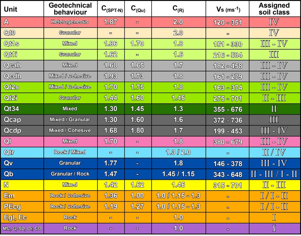
12 Statistical synthesis of geotechnical parameters Carried out for each one of the lithostratigraphical soil units (Quaternary, Neogene and some altered rock units). Summarized parameters: i) In situ tests: - Standard penetration test blow count, SPT-N - Dynamic Probing Super Heavy penetration test, DPSH-N ii) Laboratory tests on soil samples: - Unconfined shear strength, Qu - Granulometric percentages, especially fine content - Atterberg limits and Casagrande plasticity charts - Dry-wet density and natural humidity content 11

13 NCSE-02 sets direct correlation of SPT-N and Qu with: - Seismic soil class - Soil coefficient C - Shear wave velocities, Vs Inferred after code definitions about compactness of granular materials and consistency of cohesive materials, by comparison to values published in the geotechnical literature 12

14 Synthesis of SPT-N data for soil units Mainly soil class III-IV Mainly soil class II-III 13

15 Synthesis of Qu data for cohesive soil units Soil class III - IV 14
 C (Q u)")
16 4. Seismic parameterization of soil and rock units Soil coefficient C calculated by two parallel ways for each unit: - Based on SPT-N data - Based on Qu data C (SPT-N) C (Q u) 15
17 A representative soil coefficient C(R) for all the units is derived from integrated consideration of: - C (SPT-N) - C (Qu) - Granulometric percentages and fine content (granular/cohesive/mixed geotechnical character) - Density, humidity, plasticity and other descriptive information Additionally, shear wave velocities V s have been calculated for each individual SPT value by empirical equivalences (Kanai et al., 1966), and then summarized by units. V s = 62 SPT-N
18
19 5. Site soil amplification (NCSE-02) Seismic calculus acceleration a c is: a c = S ρ PGA S: Soil amplification factor ρ: non-dimensional risk coefficient ( for normal-special importance buildings) Since PGA (Girona area) is , then S (PGA<0.1) = C / 1.25 Soil coefficient C is a good indicator in estimation of soil effect: C i : Soil coefficient C e i : individual thickness for all the soil class layers in the first 30 m from the surface 18
20 Database: great heterogeneity in the amount, precision and confidence of available data among the prospection points. 0 m 30 m SPT-N Soil sample Quaternary SPT-N Soil sample Neogene or Rock SPT-N - Borehole: 30 m? Pre-Quaternary substratum? Continuous/discontinuous core? Representativeness of the core? Dynamic probing log? (no core) - Lithology levels: Valid SPT-N data? (not refusal) Lab. resistance tests on unaltered soil samples? 19
21 Need of systematization in the process to obtain C 1,530 boreholes: many boreholes with few or poorly constrained data C i C 1 C 2 e i e 1 e 2 Standardized C i calculation method by weighted contribution of C i(spt-n), C i(qu), C (R) (25 typological cases) i) After in situ penetration tests: C i(spt-n) % C (R) Cases N1 to N8 C 3... e 3... ii) After laboratory resistance tests: C n e n C i(qu) % C (R) Cases M1 to M6 iii) From extrapolation: C (R) Rock Cases R1 to R3 Soil Cases S1 to S7 Anthropogenic Case A1 20
 Example of C and I qc calculation for one borehole:")
22 Additionally, each C i case is attributed to a quality (confidence) index, I qci I qc I qci I qci: 1-4 (poor to very good C i confidence) Example of C and I qc calculation for one borehole: 21
23 C I qc 1,328 boreholes 22

24 6. Basic level seismic microzonation C coefficient isoamplification zones Zone A-1 Rock cropping out or covered by a thin layer of Quaternary sediments. Zone A-2 Rock overlain by 5-20 meters of low seismic quality Quaternary sediments. Zone B i) Neogene sediments, ii) Quaternary alluviums up to 20 m thick overlying Neogene, iii) weathered Quaternary lava flow up to 15 m thick, over Quaternary and Neogene sediments. Zone C Local thick, soft Quaternary alluviums on Neogene.
25 7. Conclusions Geotechnical databases: a valuable source of ground information for basic seismic analysis. Direct correlation of geotechnical and geological characteristics to soil dynamic parameters by means of published equivalences (seismic building codes). Weighted contribution of seismic parameters obtained by parallel, complementary ways allows to get standardized seismic data, instead of how much / how good available information comes out from the boreholes. 24

26 7. Conclusions (continued) This methodology reveals as a good complement in the determination of local seismic response from other direct techniques. Resulting microzonation sets a starting tool for more specific targets: field geophysical measurements, numerical simulations in selected emplacements, and performance of risk scenarios. Data compilation, filtering and processing is time consuming. Geotechnical investigations are usually shallow. NCSE-02 only considers soil effect up to 30 m depth. 25
27 Vi ringrazio per la vostra attenzione
Performing seismic scenarios in the Luchon-Val d Aran area, Central Pyrenees
 Performing seismic scenarios in the Luchon-Val d Aran area, Central Pyrenees 7th EUROGEO, Bologna, Italy, 12th-15th june 2012 Authors: A. Roullé (BRGM), A. Macau (IGC), S. Figueras (IGC), D. Monfort- Climent
CHAPTER 3 METHODOLOGY
 32 CHAPTER 3 METHODOLOGY 3.1 GENERAL In 1910, the seismological society of America identified the three groups of earthquake problems, the associated ground motions and the effect on structures. Indeed
Seismic risk assessment for the city of Girona, Spain
 Seismic risk assessment for the city of Girona, Spain J. Irizarry, A. Macau, S. Figueras & X. Goula Institut Geològic de Catalunya, Barcelona, Spain N. Lantada, S. Vendrell & L.G. Pujades Department of
GNS Science, Lower Hutt, New Zealand NZSEE Conference
 A Ground Shaking Amplification Map for New Zealand U. Destegul, G. Dellow & D. Heron GNS Science, Lower Hutt, New Zealand. 2008 NZSEE Conference ABSTRACT: A ground shaking amplification map of New Zealand
SURFACE GEOLOGY AND LIQUEFACTION SUSCEPTIBILITY IN THE INNER RIO GRANDE VALLEY NEAR ALBUQUERQUE, NEW MEXICO
 SURFACE GEOLOGY AND LIQUEFACTION SUSCEPTIBILITY IN THE INNER RIO GRANDE VALLEY NEAR ALBUQUERQUE, NEW MEXICO Keith I. Kelson, Christopher S. Hitchcock, and Carolyn E. Randolph William Lettis & Associates,
Project S4: ITALIAN STRONG MOTION DATA BASE. Deliverable # D3. Definition of the standard format to prepare descriptive monographs of ITACA stations
 Agreement INGV-DPC 2007-2009 Project S4: ITALIAN STRONG MOTION DATA BASE Responsibles: Francesca Pacor, INGV Milano Pavia and Roberto Paolucci, Politecnico Milano http://esse4.mi.ingv.it Deliverable #
Evaluation of the Liquefaction Potential by In-situ Tests and Laboratory Experiments In Complex Geological Conditions
 Evaluation of the Liquefaction Potential by In-situ Tests and Laboratory Experiments In Complex Geological Conditions V. Sesov, K. Edip & J. Cvetanovska University Ss. Cyril and Methodius, Institute of
PROCEEDINGS PIT IAGI YOGYAKARTA 2012 The 41 st IAGI Annual Convention and Exhibition
 EG-25 COMPARING QUALITATIVE AND QUANTITATIVE METHOD TO DETERMINE EARTHQUAKE SUSCEPTIBILITY LEVEL AT KULON PROGO, YOGYAKARTA by: Deasy Rimanda Cahyaningtyas (1), Prof. Dr. Kirbani Sri Brotopuspito (2) Salahuddin
Effects of Surface Geology on Seismic Motion
 4 th IASPEI / IAEE International Symposium: Effects of Surface Geology on Seismic Motion August 23 26, 2011! University of California Santa Barbara MICROZONATION OF MONTREAL, VARIABILITY IN SOIL CLASSIFICATION
Impact : Changes to Existing Topography (Less than Significant)
") 4.2 Land Resources 4.2.1 Alternative A Proposed Action Impact 4.2.1-1: Changes to Existing Topography (Less than Significant) Development of the project site would involve grading and other earthwork as
4.2 Land Resources 4.2.1 Alternative A Proposed Action Impact 4.2.1-1: Changes to Existing Topography (Less than Significant) Development of the project site would involve grading and other earthwork as
1.1 Calculation methods of the liquefaction hazard.
 1 Theoretical basis 1.1 Calculation methods of the liquefaction hazard. 1.1.1 Empirical methods. Empirical methods are generally used to get a rough estimate of the liquefaction hazard in saturated sandy
Micro Seismic Hazard Analysis
 Micro Seismic Hazard Analysis Mark van der Meijde INTERNATIONAL INSTITUTE FOR GEO-INFORMATION SCIENCE AND EARTH OBSERVATION Overview Site effects Soft ground effect Topographic effect Liquefaction Methods
SITE EFFECTS STUDY USING AMBIENT VIBRATIONS H/V AT ALGIERS BAY (ALGERIA)
") SITE EFFECTS STUDY USING AMBIENT VIBRATIONS H/V AT ALGIERS BAY (ALGERIA) Djamel Machane 1 Ghani Cheikh Lounis, Mustapha Hellel, Rabah Bensalem, El Hadi Oubaiche, Hakim Moulouel, Sahra Ourari, Thabet Zemmouri,
SITE EFFECTS STUDY USING AMBIENT VIBRATIONS H/V AT ALGIERS BAY (ALGERIA) Djamel Machane 1 Ghani Cheikh Lounis, Mustapha Hellel, Rabah Bensalem, El Hadi Oubaiche, Hakim Moulouel, Sahra Ourari, Thabet Zemmouri,
Seismic microzonation in two Pyrenean Valleys: Val d Aran and Luchonnais
 Seismic microzonation in two Pyrenean Valleys: Val d Aran and Luchonnais A. Macau & S. Figueras Institut Geològic de Catalunya, Spain A. Roullé & L. Kingne Bureau de Recherches Géologiques et Minières,
Boreholes. Implementation. Boring. Boreholes may be excavated by one of these methods: 1. Auger Boring 2. Wash Boring 3.
 Implementation Boreholes 1. Auger Boring 2. Wash Boring 3. Rotary Drilling Boring Boreholes may be excavated by one of these methods: 4. Percussion Drilling The right choice of method depends on: Ground
Probabilistic Earthquake Risk Assessment of Newcastle and Lake Macquarie Part 1 Seismic Hazard.
 Probabilistic Earthquake Risk Assessment of Newcastle and Lake Macquarie Part 1 Seismic Hazard. T. Dhu, D. Robinson, C. Sinadinovski, T. Jones, A. Jones & J. Schneider Geoscience Australia, Canberra, Australia.
Unique Site Conditions and Response Analysis Challenges in the Central and Eastern U.S.
 Unique Site Conditions and Response Analysis Challenges in the Central and Eastern U.S. James R. Martin, C. Guney Olgun, & Morgan Eddy Civil and Environmental Engineering World Institute for Disaster Risk
DEVELOPMENT OF EMPIRICAL CORRELATION BETWEEN SHEAR WAVE VELOCITY AND STANDARD PENETRATION RESISTANCE IN SOILS OF CHENNAI CITY
 DEVELOPMENT OF EMPIRICAL CORRELATION BETWEEN SHEAR WAVE VELOCITY AND STANDARD PENETRATION RESISTANCE IN SOILS OF CHENNAI CITY Uma Maheswari R 1, Boominathan A 2 and Dodagoudar G.R 3 1 Research Scholar,
SOME GEOTECHNICAL PROPERTIES OF KLANG CLAY
 SOME GEOTECHNICAL PROPERTIES OF KLANG CLAY Y.C. Tan, S.S. Gue, H.B. Ng 3, P.T. Lee 4 ABSTRACT A series of subsurface investigation including in-situ and laboratory tests has been carefully planned and
Dept. of Earth and Environmental Sciences, University of Waterloo, 200 University Ave W, Waterloo, Ontario, Canada, N2L 3G1 2
 A modelling strategy to develop a regional Quaternary geological model across rural and urban areas and administrative borders using existing geological information M. Ross 1, M. Parent 2, A. Taylor 1
In situ dynamic characterization of soils by means of measurement uncertainties and random variability
 Computational Methods and Experiments in Materials Characterisation III 339 In situ dynamic characterization of soils by means of measurement uncertainties and random variability G. Vessia & C. Cherubini
Seismic hazard analysis and microzonation of Coimbatore Corporation
 Indian Journal of Geo Marine Sciences Vol.46 (11), November 2017, pp. 2207-2214 Seismic hazard analysis and microzonation of Coimbatore Corporation K E Viswanathan 1 & K Elangovan 2 1 Department of Civil
We N Geophysical Near-surface Characterization for Static Corrections: Multi-physics Survey in Reggane Field, Algeria
 We N114 01 Geophysical Near-surface Characterization for Static Corrections: Multi-physics Survey in Reggane Field, Algeria A. Pineda* (Repsol), S. Gallo (CGG) & H. Harkas (GRN Sonatrach) SUMMARY We are
Improvements to the Development of Acceleration Design Response Spectra. Nicholas E. Harman, M.S., P.E., SCDOT
 Improvements to the Development of Acceleration Design Response Spectra Nicholas E. Harman, M.S., P.E., SCDOT Thanks Clemson University Dr. Ron Andrus Co-Principal Investigator Dr. Nadarajah Ravichandran
Gotechnical Investigations and Sampling
 Gotechnical Investigations and Sampling Amit Prashant Indian Institute of Technology Gandhinagar Short Course on Geotechnical Investigations for Structural Engineering 12 14 October, 2017 1 Purpose of
FUNDAMENTALS OF ENGINEERING GEOLOGY
 FUNDAMENTALS OF ENGINEERING GEOLOGY Prof. Dr. HUSSEIN HAMEED KARIM Building and Construction Engineering Department 2012 Preface The impulse to write this book stemmed from a course of geology given by
Table of Contents Chapter 1 Introduction to Geotechnical Engineering 1.1 Geotechnical Engineering 1.2 The Unique Nature of Soil and Rock Materials
 Table of Contents Chapter 1 Introduction to Geotechnical Engineering 1.1 Geotechnical Engineering 1.2 The Unique Nature of Soil and Rock Materials 1.3 Scope of This Book 1.4 Historical Development of Geotechnical
NORTH OF TEHRAN SITE EFFECT MICROZONATION
 13 th World Conference on Earthquake Engineering Vancouver, B.C., Canada August 1-6, 2004 Paper No. 3423 NORTH OF TEHRAN SITE EFFECT MICROZONATION M.K. Jafari 1, M.Kamalian 2, A.Razmkhah 3, A.Sohrabi 4
SCENARIO DESIGN ON THE IMPACT OF A HIGH-MAGNITUDE EARTHQUAKE IN THE CITY OF LIMA, PERU
 SCENARIO DESIGN ON THE IMPACT EARTHQUAKE IN THE CITY OF LIMA, Methodology Determination of the characteristics of the probable earthquake (magnitude, intensity, acceleration). Seismic geotechnical soil
INTRODUCTION. Climate
 INTRODUCTION Climate Landslides are serious natural disasters in many parts of the world. Since the past 30 years, rainfall triggered landslides and debris flows had been one of the natural disasters of
New Plymouth CBD Site Subsoil Class: Results from ground investigation
 Alexander, G.J., Chin, C.Y., Kayser, C. & Bradshaw, J. (2017) New Plymouth CBD Site Subsoil Proc. 20 th NZGS Geotechnical Symposium. Eds. GJ Alexander & CY Chin, Napier New Plymouth CBD Site Subsoil Class:
iii CONTENTS vii ACKNOWLEDGMENTS EXECUTIVE SUMMARY INTRODUCTION Study Area Data Sources Preparation of Geologic Maps
 CONTENTS ACKNOWLEDGMENTS EXECUTIVE SUMMARY INTRODUCTION Study Area Data Sources Preparation of Geologic Maps GEOLOGY Bedrock Geology Succession and Distribution Structural Features Description of Bedrock
(C) Global Journal of Engineering Science and Research Management
 Global Journal of Engineering Science and Research Management") GEOTECHNCIAL ASSESSMENT OF PART OF PORT HARCOURT, NIGER DELTA FOR STRUCTURAL ANALYSIS Warmate Tamunonengiyeofori Geostrat International Services Limited, www.geostratinternational.com. *Correspondence
GEOTECHNCIAL ASSESSMENT OF PART OF PORT HARCOURT, NIGER DELTA FOR STRUCTURAL ANALYSIS Warmate Tamunonengiyeofori Geostrat International Services Limited, www.geostratinternational.com. *Correspondence
Mass Wasting. Revisit: Erosion, Transportation, and Deposition
 Mass Wasting Revisit: Erosion, Transportation, and Deposition While landslides are a normal part of erosion and surface processes, they can be very destructive to life and property! - Mass wasting: downslope
Integration of Seismic Refraction and 2D Electrical Resistivity in Locating Geological Contact
 Open Journal of Geology, 2013, 3, 7-12 doi:10.4236/ojg.2013.32b002 Published Online April 2013 (http://www.scirp.org/journal/ojg) Integration of Seismic Refraction and 2D Electrical Resistivity in Locating
ESTIMATION OF SEDIMENT THICKNESS BY USING MICROTREMOR OBSERVATIONS AT PALU CITY, INDONESIA. Pyi Soe Thein. 11 November 2013
 ESTIMATION OF SEDIMENT THICKNESS BY USING MICROTREMOR OBSERVATIONS AT PALU CITY, INDONESIA By Pyi Soe Thein 11 November 2013 Outlines Introduction Research objectives Research analyses Microtremor Single
Effects of Surface Geology on Seismic Motion
 4 th IASPEI / IAEE International Symposium: Effects of Surface Geology on Seismic Motion August 23 26, 2011 University of California Santa Barbara EFFECTS OF TOPOGRAPHIC POSITION AND GEOLOGY ON SHAKING
IN SITU TESTING TECHNOLOGY FOR FOUNDATION & EARTHQUAKE ENGINEERING. Wesley Spang, Ph.D., P.E. AGRA Earth & Environmental, Inc.
 IN SITU TESTING TECHNOLOGY FOR FOUNDATION & EARTHQUAKE ENGINEERING Wesley Spang, Ph.D., P.E. AGRA Earth & Environmental, Inc. Portland, Oregon In situ testing of soil, which essentially consists of evaluating
Ground-shaking scenarios and urban risk evaluation of Barcelona using the Risk-UE capacity spectrum based method
 Ground-shaking scenarios and urban risk evaluation of Barcelona using the Risk-UE capacity spectrum based method Bulletin of Earthquake Engineering Official Publication of the European Association for
Seismic Site Classification and Soil Amplification Assessment of Chiang Rai City, Northern Thailand
 Seismic Site Classification and Soil Amplification Assessment of Chiang Rai City, Northern Thailand Ratchadaporn Jintaprasat and Thanop Thitimakorn 1 Department of Geology, Faculty of Science, Chulalongkorn
Preliminary Earthquake Risk Management Strategy Plan of Eskisehir, Turkey by using GIS
 Preliminary Earthquake Risk Management Strategy Plan of Eskisehir, Turkey by using GIS Metin Altan, Ferah Özturk and Can Ayday Space and Satellite Sciences Research Institute Anadolu University, TURKEY
Pierce County Department of Planning and Land Services Development Engineering Section
 Page 1 of 7 Pierce County Department of Planning and Land Services Development Engineering Section PROJECT NAME: DATE: APPLICATION NO.: PCDE NO.: LANDSLIDE HAZARD AREA (LHA) GEOLOGICAL ASSESSMENT REPORT
GEOTECHNICAL ENGINEERING INVESTIGATION HANDBOOK Second Edition
 GEOTECHNICAL ENGINEERING INVESTIGATION HANDBOOK Second Edition Roy E. Hunt Taylor & Francis Taylor & Francis Croup Boca Raton London New York Singapore A CRC title, part of the Taylor & Francis imprint,
EARTHQUAKE HAZARD ASSESSMENT IN KAZAKHSTAN
 EARTHQUAKE HAZARD ASSESSMENT IN KAZAKHSTAN Dr Ilaria Mosca 1 and Dr Natalya Silacheva 2 1 British Geological Survey, Edinburgh (UK) imosca@nerc.ac.uk 2 Institute of Seismology, Almaty (Kazakhstan) silacheva_nat@mail.ru
LIQUEFACTION ASSESSMENT OF INDUS SANDS USING SHEAR WAVE VELOCITY
 Pakistan Engineering Congress, 69th Annual Session Proceedings 219 LIQUEFACTION ASSESSMENT OF INDUS SANDS USING SHEAR WAVE VELOCITY Sohail Kibria 1, M. Javed 2, Muhammad Ali 3 ABSTRACT A host of procedures
Flexible soils amplified the damage in the 2010 Haiti earthquake
 Earthquake Soil Interaction 45 Flexible soils amplified the damage in the 2010 Haiti earthquake R. O. de León Sciences Academy of the Dominican Republic, Dominican Republic Abstract On January 12 th, 2010,
4.17 Spain. Catalonia
 4.17 Spain Catalonia In Spain, inundation studies are the responsibility of the respective Hydrographic Confederations of each river basin (River Basin Authorities). The actual status of inundation studies
ACCOUNTING FOR SITE EFFECTS IN PROBABILISTIC SEISMIC HAZARD ANALYSIS: OVERVIEW OF THE SCEC PHASE III REPORT
 ACCOUNTING FOR SITE EFFECTS IN PROBABILISTIC SEISMIC HAZARD ANALYSIS: OVERVIEW OF THE SCEC PHASE III REPORT Edward H FIELD 1 And SCEC PHASE III WORKING GROUP 2 SUMMARY Probabilistic seismic hazard analysis
PREDICTION OF AVERAGE SHEAR-WAVE VELOCITY FOR GROUND SHAKING MAPPING USING THE DIGITAL NATIONAL LAND INFORMATION OF JAPAN
 th World Conference on Earthquake Engineering Vancouver, B.C., Canada August -6, 00 Paper No. 07 PREDICTION OF AVERAGE SHEAR-WAVE VELOCITY FOR GROUND SHAKING MAPPING USING THE DIGITAL NATIONAL LAND INFORMATION
Appendix J. Geological Investigation
 Appendix J Geological Investigation Appendix J Geological Environment Table of Contents Page 1 INTRODUCTION...J-1 1.1 Purpose of the Investigation...J-1 1.2 Scope of the Investigation...J-1 2 METHODO OF
Global Journal of Engineering Science and Research Management
 GEOTECHNICAL STUDY OF BAGHDAD SOIL Hussein H. Karim*, Safaa J. Wadaa * Professor, Building and Construction Engineering Department, University of Technology, Baghdad- Iraq M.Sc. in Geotechnical Engineering,
WORKSHOP ON PENETRATION TESTING AND OTHER GEOMECHANICAL ISSUES Pisa 14 June 2016 ROOM F8
 WORKSHOP ON PENETRATION TESTING AND OTHER GEOMECHANICAL ISSUES Pisa 14 June 2016 ROOM F8 LIQUEFACTION PHOENOMENA DURING THE EMILIA SEISMIC SEQUENCE OF 2012 AND THE LIQUEFACTION POTENTIAL FROM A LARGE DATABASE
Flexible soils amplified the damage in the 2010 Haiti earthquake
 Earthquake Resistant Engineering Structures IX 433 Flexible soils amplified the damage in the 2010 Haiti earthquake R. O. de León Sciences Academy of Dominican Republic Abstract On January 12 th, 2010,
Chapter 12 Subsurface Exploration
 Page 12 1 Chapter 12 Subsurface Exploration 1. The process of identifying the layers of deposits that underlie a proposed structure and their physical characteristics is generally referred to as (a) subsurface
Geotechnical Indications Of Eastern Bypass Area In Port Harcourt, Niger Delta
 Geotechnical Indications Of Eastern Bypass Area In Port Harcourt, Niger Delta Warmate Tamunonengiyeofori Geostrat International Services Limited, Rivers State, Nigeria www.geostratinternational.com info@geostratinternational.com,
REGARDING SOME DYNAMIC CHARACTERISTICS OF THE SOILS AND THE LIQUIFACTION POTENTIAL OF SANDS IN SOFIA
 REGARDING SOME DYNAMIC CHARACTERISTICS OF THE SOILS AND THE LIQUIFACTION POTENTIAL OF SANDS IN SOFIA Chief Ass. Prof. Ivailo Ivanov University of Architecture, Civil Engineering and Geodesy Department
Refraction Microtremor for Shallow Shear Velocity in Urban Basins
 Refraction Microtremor for Shallow Shear Velocity in Urban Basins John Louie, Nevada Seismological Lab UNR students: J. B. Scott, T. Rasmussen, W. Thelen, M. Clark Collaborators: S. Pullammanappallil &
Seismic Reflection Imaging across the Johnson Ranch, Valley County, Idaho
 Seismic Reflection Imaging across the Johnson Ranch, Valley County, Idaho Report Prepared for the Skyline Corporation Lee M. Liberty Center for Geophysical Investigation of the Shallow Subsurface (CGISS)
Comparison of different methods for evaluating the liquefaction potential of sandy soils in Bandar Abbas
 Comparison of different methods for evaluating the liquefaction potential of sandy soils in Bandar Abbas M. Mosaffa¹ & M. Rafiee² 1.Geotechnical M.S. student Hormozgan University, Bandar Abbas, Iran(Email:Amestris@gmail.com).Geotechnical
The Role of Local Site Conditions in The Seismic Assessment of Historical Monuments
 The Role of Local Site Conditions in The Seismic Assessment of Historical Monuments J. Cvetanovska, V. Sesov, I. Gjorgiev & K. Edip Univeristy Ss. Cyril and Methodius, Institute of Earthquake Engineering
IN SITU SPECIFIC GRAVITY VS GRAIN SIZE: A BETTER METHOD TO ESTIMATE NEW WORK DREDGING PRODUCTION
 IN SITU SPECIFIC GRAVITY VS GRAIN SIZE: A BETTER METHOD TO ESTIMATE NEW WORK DREDGING PRODUCTION Nancy Case O Bourke, PE 1, Gregory L. Hartman, PE 2 and Paul Fuglevand, PE 3 ABSTRACT In-situ specific gravity
Tu 22P1 04 Combination of Geophysical Technques to Characterize Sediments (Ebro Delta, Spain)
") Tu 22P1 04 Combination of Geophysical Technques to Characterize Sediments (Ebro Delta, Spain) B. Benjumea* (Institut Cartografic i Geologic de Catalunya (ICGC)), A. Gabàs (ICGC), A. Macau (ICGC), F. Bellmunt
Tu 22P1 04 Combination of Geophysical Technques to Characterize Sediments (Ebro Delta, Spain) B. Benjumea* (Institut Cartografic i Geologic de Catalunya (ICGC)), A. Gabàs (ICGC), A. Macau (ICGC), F. Bellmunt
Liquefaction Potential Post-Earthquake in Yogyakarta
 The 17 th Southeast Asian Geotechnical Conference Taipei, Taiwan, May 10~13, 2010 Liquefaction Potential Post-Earthquake in Yogyakarta AGUS SETYO MUNTOHAR 1 and S.P.R. WARDANI 2 1 Department of Civil Engineering,
Case Study - Undisturbed Sampling, Cyclic Testing and Numerical Modelling of a Low Plasticity Silt
 6 th International Conference on Earthquake Geotechnical Engineering 1-4 November 2015 Christchurch, New Zealand Case Study - Undisturbed Sampling, Cyclic Testing and Numerical Modelling of a Low Plasticity
Geotechnical Aspects of the Seismic Update to the ODOT Bridge Design Manual. Stuart Edwards, P.E Geotechnical Consultant Workshop
 Geotechnical Aspects of the Seismic Update to the ODOT Bridge Design Manual Stuart Edwards, P.E. 2017 Geotechnical Consultant Workshop Changes Role of Geotechnical Engineer Background Methodology Worked
Comparison of CPT Based Liquefaction Potential and Shear Wave Velocity Maps by Using 3-Dimensional GIS
 Comparison of CPT Based Liquefaction Potential and Shear Wave Velocity Maps by Using 3-Dimensional GIS Muammer Tün, Uğur Avdan, Metin Altan, Can Ayday Anadolu University, Satellite and Space Sciences Research
EVALUATION OF SEISMIC SITE EFFECTS FOR BANGKOK DEEP BASIN
 EVALUATION OF SEISMIC SITE EFFECTS FOR BANGKOK DEEP BASIN Nakhorn POOVARODOM 1 and Amorntep JIRASAKJAMROONSRI 2 ABSTRACT In this study, seismic site effects of Bangkok focusing on deep basin structures
Pinyol, Jordi González, Marta Oller, Pere Corominas, Jordi Martínez, Pere
 Rockfall hazard mapping methodology applied to the Geological Hazard Prevention Map in Catalonia 1:25000 Pinyol, Jordi González, Marta Oller, Pere Corominas, Jordi Martínez, Pere ROCKFALL HAZARD MAPPING
Setting MOUNTAIN HOUSE NEIGHBORHOODS I AND J INITIAL STUDY 5. ENVIRONMENTAL CHECKLIST 6. GEOLOGY AND SOILS. Issue
 Issue Less Than Significant or No Impact Potential Significant Impact Adequately Addressed in MEIR MEIR Required Additional Review: No Significant Impact Less Than Significant Impact Due to Mitigation
The Subsurface Soil Effects Study Using the Short and Long Predominant Periods From H/V Spectrum In Yogyakarta City
 Paper ID 90 The Subsurface Soil Effects Study Using the Short and Long Predominant Periods From H/V Spectrum In Yogyakarta City Z.L. Kyaw 1,2*, S. Pramumijoyo 2, S. Husein 2, T.F. Fathani 3, J. Kiyono
DEFINITION OF EXPANSION POTENTIAL FOR EXPANSIVE SOIL John D. Nelson 1,2, Kuo-Chieh Chao 2 & Daniel D. Overton 2
 DEFINITION OF EXPANSION POTENTIAL FOR EXPANSIVE SOIL John D. Nelson 1,2, Kuo-Chieh Chao 2 & Daniel D. Overton 2 1 ) Colorado State University, USA 2 ) Tetra Tech, Inc., USA Abstract: Expansion potential
Seismic site response analysis for Australia
 Seismic site response analysis for Australia Anita Amirsardari 1, Elisa Lumantarna 2, Helen M. Goldsworthy 3 1. Corresponding Author. PhD Candidate, Department of Infrastructure Engineering, University
Geological Mapping using Geophysics
 Geological Mapping using Geophysics Pugin, A.J.M. and T.H. Larson Illinois State Geological Survey, 615 E Peabody Dr., Champaign, IL 61820; E-mail: A.J.M. Pugin at pugin@isgs.uiuc.edu Mapping Techniques.
ShakeMap implementation for Pyrenees in France-Spain border: regional adaptation and earthquake rapid response process
 ShakeMap implementation for Pyrenees in France-Spain border: regional adaptation and earthquake rapid response process D. Bertil Bureau de Recherches Géologiques et Minières (BRGM) J. Roviró Institut Geològic
Effect of multicyclic compaction on cohesion in lateritic soils
 Available online at www.scholarsresearchlibrary.com Scholars Research Library Archives of Applied Science Research, 2011, 3 (3):115-121 (http://scholarsresearchlibrary.com/archive.html) ISSN 0975-8X CODEN
Delineation of Zones at Risk from Groundwater Inflows at an Underground Platinum Mine in South Africa
 Delineation of Zones at Risk from Groundwater Inflows at an Underground Platinum Mine in South Africa Mr Andreas Stoll andreas.stoll@erm.com Environmental Resources Management Swiss GmbH (ERM), Switzerland
Evaluation of Landslide Hazard Assessment Models at Regional Scale (SciNet NatHazPrev Project)
") Evaluation of Landslide Hazard Assessment Models at Regional Scale (SciNet NatHazPrev Project) Democritus University of Thrace (P1) Department of Civil Engineering Geotechnical Division Scientific Staff:
Evaluation of Landslide Hazard Assessment Models at Regional Scale (SciNet NatHazPrev Project) Democritus University of Thrace (P1) Department of Civil Engineering Geotechnical Division Scientific Staff:
Safety analyses of Srinagarind dam induced by earthquakes using dynamic response analysis method.
 Safety analyses of Srinagarind dam induced by earthquakes using dynamic response analysis method. S. Soralump Assistance Professor, Faculty of Engineering, Kasetsart University, Thailand. K. Tansupo Ph.D.
Assessing the Ground Response to Urbanization in the Fiumicino area by Combining Geological and Geotechnical Data with Satellite InSAR Data
 Assessing the Ground Response to Urbanization in the Fiumicino area by Combining Geological and Geotechnical Data with Satellite InSAR Data P. Mazzanti F. Bozzano, C. Esposito, M. Patti, A. Rocca La Missione
IAEA SAFETY STANDARDS Geotechnical Aspects of Site Evaluation and Foundations in NPPs, NS-G-3.6
 IAEA SAFETY STANDARDS Geotechnical Aspects of Site Evaluation and Foundations in NPPs, NS-G-3.6 Regional Workshop on Volcanic, Seismic, and Tsunami Hazard Assessment Related to NPP Siting Activities and
EMPIRICAL EVIDENCE FROM THE NORTHRIDGE EARTHQUAKE FOR SITE- SPECIFIC AMPLIFICATION FACTORS USED IN US BUILDING CODES
 EMPIRICAL EVIDENCE FROM THE NORTHRIDGE EARTHQUAKE FOR SITE- SPECIFIC AMPLIFICATION FACTORS USED IN US BUILDING CODES Roger D BORCHERDT And Thomas E FUMAL SUMMARY Site-specific amplification factors, F
ELECTRICAL RESISTIVITY TOMOGRAPHY
 NOTIO Association Clay Technological Centre C/ Río Cabriel s/n 45007 Toledo Tel.: 925 24 11 62 info@notio.es www.notio.es Page 1 / 7 SUMMARY 1. PHYSICAL FUNDAMENTALS OF THE... 3 1.1. ELECTRICAL BEHAVIOR
Geophysics for Environmental and Geotechnical Applications
 Geophysics for Environmental and Geotechnical Applications Dr. Katherine Grote University of Wisconsin Eau Claire Why Use Geophysics? Improve the quality of site characterization (higher resolution and
Geophysical Site Investigation (Seismic methods) Amit Prashant Indian Institute of Technology Gandhinagar
 Amit Prashant Indian Institute of Technology Gandhinagar") Geophysical Site Investigation (Seismic methods) Amit Prashant Indian Institute of Technology Gandhinagar Short Course on Geotechnical Aspects of Earthquake Engineering 04 08 March, 2013 Seismic Waves
Geophysical Site Investigation (Seismic methods) Amit Prashant Indian Institute of Technology Gandhinagar Short Course on Geotechnical Aspects of Earthquake Engineering 04 08 March, 2013 Seismic Waves
The significance of site effect studies for seismic design and assessment of industrial facilities
 The significance of site effect studies for seismic design and assessment of industrial facilities Corinne Lacave, Martin G. Koller Pierino Lestuzzi, and Christelle Salameh Résonance Ingénieurs-Conseils
Developing a 7.5-sec site-condition map for Japan based on geomorphologic classification
 Earthquake Resistant Engineering Structures VIII 101 Developing a 7.5-sec site-condition map for Japan based on geomorphologic classification K. Wakamatsu 1 & M. Matsuoka 2 1 Department of Civil and Environmental
Japan Seismic Hazard Information Station
 Japan Seismic Hazard Information Station (J-SHIS) Hiroyuki Fujiwara National Research Institute for Earth Science and Disaster Prevention (NIED) Background of the Project Headquarters for Earthquake Research
GEOLOGICAL BASED SEISMIC MACROZONATION FOR PYRENEES
 Cliquez et modifiez le titre GEOLOGICAL BASED SEISMIC MACROZONATION FOR PYRENEES Bologna, 2012-06-14 COLAS Bastien (1) ; GARCÍA Iván (2), BUXÓ Pere (2), ROULLÉ Agathe (1) and GOULA Xavier (3) (1) BRGM,
Guidelines for Site-Specific Seismic Hazard Reports for Essential and Hazardous Facilities and Major and Special-Occupancy Structures in Oregon
 Guidelines for Site-Specific Seismic Hazard Reports for Essential and Hazardous Facilities and Major and Special-Occupancy Structures in Oregon By the Oregon Board of Geologist Examiners and the Oregon
Investigation of Liquefaction Behaviour for Cohesive Soils
 Proceedings of the 3 rd World Congress on Civil, Structural, and Environmental Engineering (CSEE 18) Budapest, Hungary April 8-10, 2018 Paper No. ICGRE 134 DOI: 10.11159/icgre18.134 Investigation of Liquefaction
OIKOS > landslide > mechanism >predisposing causes
 predisposing causes and trigger OIKOS > landslide > mechanism >predisposing causes Landslides are events that occur in space and time. As such, it is usually possible to identify both one or more landslide
SASKATCHEWAN STRATIGRAPHY GLACIAL EXAMPLE BOULDERS IN GLACIAL DEPOSITS
 SASKATCHEWAN STRATIGRAPHY GLACIAL EXAMPLE BOULDERS IN GLACIAL DEPOSITS 51 SASKATCHEWAN STRATIGRAPHY GLACIAL SURFICIAL STRATIFIED DEPOSITS 52 SASKATCHEWAN STRATIGRAPHY GLACIAL EXAMPLE OF SEDIMENT DEPOSITION
7. Foundation and Slope Stability
 The Asian Nuclear Safety Network 7. Foundation and Slope Stability (SER 2.5.4 & 2.5.5) Taek-Mo SHIM k147stm@kins.re.kr Korea Institute of Nuclear Safety Structural Systems and Site Evaluation Department
PROTECTING MONUMENTS AND HISTORICAL SETTINGS FROM THE NEXT EARTHQUAKE
 PROTECTING MONUMENTS AND HISTORICAL SETTINGS FROM THE NEXT EARTHQUAKE R.PAPADHMHTRIOU, L.PELLI EUROPEAN CENTER OF PREVENTING & FORECASTING OF EARTHQUAKES Confronting the problem SEISMIC RISK R SEISMIC
V S 30 and NZS site class maps of New Zealand
 V S 30 and NZS 1170.5 site class maps of New Zealand N.D. Perrin, D. Heron, A. Kaiser & C. Van Houtte Institute of Geological Sciences Ltd, Avalon, Lower Hutt 2015 NZSEE Conference ABSTRACT: Two parameters
New Design Spectral Acceleration of Soft and Deep Deposits in Bangkok
 New Design Spectral Acceleration of Soft and Deep Deposits in Bangkok N. Poovarodom & A. Jirasakjamroonsri Department of Civil Engineering, Faculty of Engineering, Thammasat University, Thailand pnakhorn@engr.tu.ac.th
The process of determining the layers of natural soil deposits that will underlie a proposed structure and their physical properties is generally
 The process of determining the layers of natural soil deposits that will underlie a proposed structure and their physical properties is generally referred to as sub surface investigation 2 1 For proper
COASTAL QUATERNARY GEOLOGY MAPPING FOR NSW: EXAMPLES AND APPLICATIONS
 COASTAL QUATERNARY GEOLOGY MAPPING FOR NSW: EXAMPLES AND APPLICATIONS A Troedson Geological Survey of New South Wales Abstract Detailed geological mapping of the coastal plains of regional NSW was undertaken
Interpretation of Subsurface Geological Structure of Massepe Geothermal Area Using Resistivity Data
 Proceedings World Geothermal Congress 2010 Bali, Indonesia, 25-29 April 2010 Interpretation of Subsurface Geological Structure of Massepe Geothermal Area Using Resistivity Data Ahmad Zarkasyi and Yuanno
Liquefaction potential of Rotorua soils
 Pearse-Danker, E. (2013) Liquefaction potential of Rotorua soils Proc. 19 th NZGS Geotechnical Symposium. Ed. CY Chin, Queenstown Liquefaction potential of Rotorua soils E Pearse-Danker Coffey Geotechnics