ESTIMATION OF SEDIMENT THICKNESS BY USING MICROTREMOR OBSERVATIONS AT PALU CITY, INDONESIA. Pyi Soe Thein. 11 November 2013
|
|
|
- Darren Payne
- 5 years ago
- Views:
Transcription


1 ESTIMATION OF SEDIMENT THICKNESS BY USING MICROTREMOR OBSERVATIONS AT PALU CITY, INDONESIA By Pyi Soe Thein 11 November 2013
2 Outlines Introduction Research objectives Research analyses Microtremor Single station observaions Microtremor Array observations Discussion

3 Introduction PALU Located in the triple junction of collision between the major plates: Eurasia, Eastern Pacific and Indo- Australia. Evolution of Neogene kinematics along the Palu-Koro fault was confirmed based on microtectonics approach, i.e.: sinistral strike-slip due to E-W compression, radial extensions caused by telescoping vertical movement of Neogene granitoid, and then left lateral with normal component displacement due to N-S extension/ E-W compression which is still active actually (Pamumijoyo et al., 1997). Tectonic Map of Sulawesi (Compiled by Priadi, 1993)
.")
4 Introduction Seismicity Epicentral distribution of some important earthquakes around Palu province ( ). (Geological Engineering Department Gadjah Mada University, 2012)

5 Introduction Location of the study area, Palu City, Central Sulawesi, Indonesia

6 Introduction Panoramic View of Palu City from West escarpment, Central Sulawesi, Indonesia
7 Research Objectives To provide sediment thickness or the depth of subsurface engineering bed rock from microtremor array observation To analyze amplification characteristics for Palu area by using trench data, borehole data and microtremor method To calculate the strong ground motion for some selected previous earthquakes compared with their damage distribution To provide a comprehensive summary of the main methods and techniques used in seismic microzoning
8 Research Analyses Microtremor single station observations Microtremor Array Observations

9 Geology of Palu Area

10 Geology of Palu Area Geological Map of Palu Depression Area (Indra, Imawan, Pohan and Juwanto, 2012)


11 Alluvium and Coastal Deposits A B A. Fossilferous limestone in Alluvium deposits. (S and E ) B. Coastal Deposits with some fossil fragment in vertical position. (S and E )


12 Celebes Molasse of Sarasin (1901) A B A. Celebes Molasse consists of mudstone. (S and E ) B. Alteration of sandrock and massive clay in Celebes Molasse. ( S and E )


13 Metamorphic Complex A B A. Typical features of schist exposed on western ridge of Palu area. ( and ) B. B. Folded schist exposed only on western ridge of Palu area. ( and )


14 Intrusive Rocks A B A. Igneous rock intruded in northwestern part of Palu area. (S and E ) B. Granite intruded in western part of Palu area. (S and E )

15 Palu-Koro Fault ASTER GDEM landsat image showing some structural features of the Palu-Koro Fault system.
16 Microtremor Microtremor(s) Constant vibrations of the Earth s surface The surface of the Earth is always in motion without earthquake. Very small amplitude Displacement : mm Far from human sensing 16


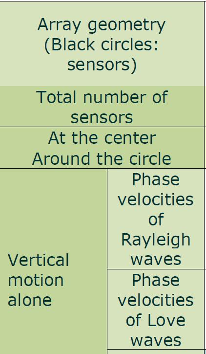
17 Single Station Observations A three-component accelerometer with data logger, GPL-6A3P, produced by the Mitsutoyo Co. Ltd., was used. The number of single point observations was 151 sites The sampling frequencies were 100 Hz or 500 Hz and the observation times were 10 to 15 minutes. Using 3 Component (Two Horizontal and One Vertical) Sensor DATA ANALYSIS: Horizontal to Vertical Spectrum Ratio (HVSR) Method Instrument of GPL 6A-3P (Mitsutoyo), Akashi Co. Ltd. Instrument of Network Senor Model VC-374 AVT. 17
 F EW (w) F UD (w) H/V Spectrum Ratio: H / V w 2 FNS w FEW w F w UD Peak Period -> Site Dominant Period 2 18")
18 Single Station Observation HVSR Method (Nakamura Method) Recoded microtremor NS EW UD 3 Component Sensor FFT FFT FFT F NS (w) F EW (w) F UD (w) H/V Spectrum Ratio: H / V w 2 FNS w FEW w F w UD Peak Period -> Site Dominant Period 2 18
19 BIDO Software NS EW UD Duration of data segments for the evaluation of spectra [s] is Spectral window [Hz] is


20 Single Station Observations 151 single station Microtremor observation sites at Palu city area
21 Predominant Period[s] Space interpolation is conducted by ordinary kriging technique The predominant periods of seconds were on the alluvial fan area. The spatial correlations between predominant periods on the west side mountain, of which slope is steep, are shorter than those in the east side mountain and change more rapidly
![Predominant Period[s] Map](/docs-images/94/118768634/images/22-2.jpg "Type A: with short period")

22 Predominant Period[s] Map Type A: with short period peak Type B: with long period peak Type C: those without clear peaks
23 Array Observations Triangle Arrray 23


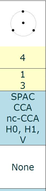
24 Array Observations Microtremor Observation Dispersion Curve Shear Wave Velocity Profile Circular Array SPAC Method 2 1 Vs1 Vs FREQUENCY(Hz) Vs3
![Phase velocity [m/s] Constructing subsurface](/docs-images/94/118768634/images/25-1.jpg "profile by inversion analysis Assume shear wave")


25 Phase velocity [m/s] Constructing subsurface profile by inversion analysis Assume shear wave profile V S =? H=? V S =? H=? V S =? Calculating Dispersion Curve (Theoretical) Update Profile Compare theoretical D.C. with Observed one 500 observed theoretical Frequency [m/s]

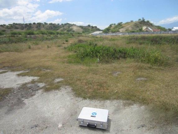
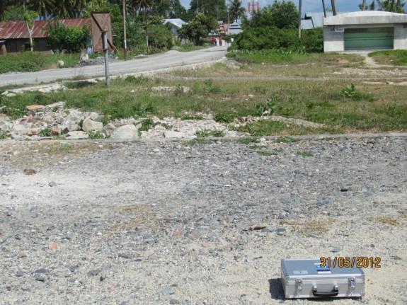
26 Array Observations The number of array observations was 8 sites. PALU CITY The sampling frequencies were 1000 Hz and the observation times were 10 to 30 minutes. Radius 3 meter, 10 meter and 30 meter at each array sites. 26
27 Phase Dispersion Velocity Curve by Dispersion by Phase Velocity Curves A spatial autocorrelation coefficient for a circular array can then be defined when the waves composing the microtremor (i.e., the subsurface waves) are dispersive. The spatial autocorrelation is a function of phase velocity and frequency. Rayleigh wave records were measured for the 8 arrray observation sites using the SPAC method and inversion analysis was undertaken on the observed dispersion curves to estimate the soil profiles. In the inversion analysis, the Particle Swarm Optimization (PSO) algorithm was adopted to solve the non-linear optimization problem 27

28 Phase Velocity by Dispersion Curves 28
29 Three Survey Lines 29
30 Estimated Ground Structure Layer No. ρ[t/ m3 ] Vp[m/s] Vs[m/s] H[m] Infinity MOP (Mayor of Palu) 30


31 Vs Structure along the Survey Lines LINE A LINE B LINE C 31
32 Two Dimensional Model LINE A LINE B LINE C 32


33 Sediment Thickness Map Palu Bay
34 Discussion Dominant in loose to medium dense sand, silt and clay sediments. Used by Kriging method (the interpolation of subsurface information such as predominant period, shear wave velocity and depth of irregular boundary) Possess hard layers in upper most 125 m and weaker sediments underlain up to 25 m depth. (According to the S-wave velocity structures from array observation)
35 Thank you very much for your kind attention
36 Concluding and Remarks Microtremor observations were carried out for constructing a subsurface ground model in Palu. Single-point observations and array observations were conducted at 151 and 8 sites respectively, which covered almost the whole city area. H/V spectra were calculated at all the single observation sites and a distribution of predominant periods was obtained. The dispersion curves of a Rayleigh wave were obtained from the data of array observations. The Kriging method can be used for the interpolation of subsurface information such as predominant period, shear wave velocity and depth of irregular boundary. By conducting an inversion analysis for the calculation of dispersion curves, the subsurface structure beneath the site can be estimated. Constructed a three layered model in each array observation point.
37 Concluding and Remarks This research was reconstructed unified two-layered model by averaging the first three layers obtained from array observation. The shear wave velocity of the top layer is Vs 300 m/s. Three dimensional structure for shear wave velocities were (I)Vs 300 m.s, (II) 300< Vs <1300 m/s and (III) Vs> 300 m/s. By combining above two-layer model and the results of single point observation, the distribution of the first layer thickness of the sediment is obtained. The shear wave velocity structure and map of Vs 300 of studied area had been successfully determined together with three dimensional model of sediment thickness or depth of engineering bedrock. It is well observed that S-wave velocity structure play an essential role in response analysis and determination of sediment thickness or depth of engineering bedrock. The shear wave velocity structure and map of Vs 300 of studied area had been successfully determined together with three dimensional model of sediment thickness or depth of engineering bedrock. It is well observed that S-wave velocity structure play an essential role in response analysis and determination of sediment thickness or depth of engineering bedrock.
Strong Ground Motion Based on Microtremor and Empirical Stochastic Green s Function Computing at Palu City, Central Sulawesi Province, Indonesia
 2014 3 rd International Conference on Geological and Environmental Sciences IPCBEE vol. 73 (2014) (2014) IACSIT Press, Singapore DOI: 10.7763/IPCBEE. 2014. V73. 11 Strong Ground Motion Based on Microtremor
Estimation of Seismic Ground Motion Induced by the 23 January, 2005 Earthquake in Palu Region, Central Sulawesi, Indonesia
 Journal of Geological Resource and Engineering 4 (2014) 200-207 doi:10.17265/2328-2193/2014.04.002 D DAVID PUBLISHING Estimation of Seismic Ground Motion Induced by the 23 January, 2005 Earthquake in Palu
Microtremors HVSR Correlation with Sub Surface Geology and Ground Shear Strain at Palu City, Central Sulawesi Province, Indonesia
 Microtremors HVSR Correlation with Sub Surface Geology and Ground Shear Strain at Palu City, Central Sulawesi Province, Indonesia PyiSoe Thein, Subagyo Pramumijoyo, Kirbani Sri Brotopuspito, Junji Kiyono,
Investigation of long period amplifications in the Greater Bangkok basin by microtremor observations
 Proceedings of the Tenth Pacific Conference on Earthquake Engineering Building an Earthquake-Resilient Pacific 6-8 November 2015, Sydney, Australia Investigation of long period amplifications in the Greater
The Subsurface Soil Effects Study Using the Short and Long Predominant Periods From H/V Spectrum In Yogyakarta City
 Paper ID 90 The Subsurface Soil Effects Study Using the Short and Long Predominant Periods From H/V Spectrum In Yogyakarta City Z.L. Kyaw 1,2*, S. Pramumijoyo 2, S. Husein 2, T.F. Fathani 3, J. Kiyono
MULTI-DIMENSIONAL VS-PROFILING WITH MICROTREMOR H/V AND ARRAY TECHNIQUES
 13 th World Conference on Earthquake Engineering Vancouver, B.C., Canada August 1-6, 2004 Paper No. 1348 MULTI-DIMENSIONAL VS-PROFILING WITH MICROTREMOR H/V AND ARRAY TECHNIQUES Kohji TOKIMATSU 1, Hiroshi
STUDY ON MICROTREMOR CHARACTERISTICS BASED ON SIMULTANEOUS MEASUREMENTS BETWEEN BASEMENT AND SURFACE USING BOREHOLE
 STUDY ON MICROTREMOR CHARACTERISTICS BASED ON SIMULTANEOUS MEASUREMENTS BETWEEN BASEMENT AND SURFACE USING BOREHOLE Takahisa ENOMOTO 1, Toshio KURIYAMA 2, Norio ABEKI 3, Takahiro IWATATE 4, Manuel NAVARRO
By D.H. Lang 1 and J. Schwarz 1. This paper is an extract from
 Identification of the Subsoil Profile Characteristics at the Coyote Creek Outdoor Classroom (CCOC), San José, from Microtremor Measurements - A Contribution to the CCOC Blind Comparison Experiment By D.H.
Seismic properties of surface layers in Shimizu by microtremor observations
 Seismic properties of surface layers in Shimizu by microtremor observations K. Kita Tokai University, Japan SUMMARY Microtremor observations were conducted to investigate seismic properties of shallow
GROUND MOTION CHARACTERISTIC IN THE KAOHSIUNG & PINGTUNG AREA, TAIWAN
 GROUND MOTION CHARACTERISTIC IN THE KAOHSIUNG & PINGTUNG AREA, TAIWAN Hsien-Jen Chiang 1, Kuo-Liang Wen 1, Tao-Ming Chang 2 1.Institute of Geophysics, National Central University,ROC 2.Department of Information
SITE EFFECTS STUDY USING AMBIENT VIBRATIONS H/V AT ALGIERS BAY (ALGERIA)
") SITE EFFECTS STUDY USING AMBIENT VIBRATIONS H/V AT ALGIERS BAY (ALGERIA) Djamel Machane 1 Ghani Cheikh Lounis, Mustapha Hellel, Rabah Bensalem, El Hadi Oubaiche, Hakim Moulouel, Sahra Ourari, Thabet Zemmouri,
SITE EFFECTS STUDY USING AMBIENT VIBRATIONS H/V AT ALGIERS BAY (ALGERIA) Djamel Machane 1 Ghani Cheikh Lounis, Mustapha Hellel, Rabah Bensalem, El Hadi Oubaiche, Hakim Moulouel, Sahra Ourari, Thabet Zemmouri,
Micro Seismic Hazard Analysis
 Micro Seismic Hazard Analysis Mark van der Meijde INTERNATIONAL INSTITUTE FOR GEO-INFORMATION SCIENCE AND EARTH OBSERVATION Overview Site effects Soft ground effect Topographic effect Liquefaction Methods
GLY 155 Introduction to Physical Geology, W. Altermann. Press & Siever, compressive forces. Compressive forces cause folding and faulting.
 Press & Siever, 1995 compressive forces Compressive forces cause folding and faulting. faults 1 Uplift is followed by erosion, which creates new horizontal surface. lava flows Volcanic eruptions cover
Chapter 3. Geology & Tectonics
 Chapter 3 Geology & Tectonics 3.1 Geology The general geological features of Indonesia are shown in Figure 3.1. The basement formation is metamorphic and it is intruded with plutonic formations. They are
Analysis of Microtremor Data Using Horizontal to Vertical Spectral Ratio (HVSR) Method of Makassar, South Sulawesi
 Method of Makassar, South Sulawesi") Analysis of Microtremor Data Using Horizontal to Vertical Spectral Ratio (HVSR) Method of Makassar, South Sulawesi 1* R. Jamroni, 2 A.M. Imran,, 2 B. Azikin 1 Master Student of Geology Department, Hasanuddin
Analysis of Microtremor Data Using Horizontal to Vertical Spectral Ratio (HVSR) Method of Makassar, South Sulawesi 1* R. Jamroni, 2 A.M. Imran,, 2 B. Azikin 1 Master Student of Geology Department, Hasanuddin
SITE EFFECTS IN CHILPANCINGO, GUERRERO, MEXICO, AND COMPARISON OF OBSERVATION WITH 1D ANALYSIS
 9 Th International Workshop on Seismic Microzoning and Risk Reduction 21 st -24 February, 21 Cuernavaca, México SITE EFFECTS IN CHILPANCINGO, GUERRERO, MEXICO, AND COMPARISON OF OBSERVATION WITH 1D ANALYSIS
Neotectonic Implications between Kaotai and Peinanshan
 Neotectonic Implications between Kaotai and Peinanshan Abstract Longitudinal Valley was the suture zone between the Philippine Sea plate and the Eurasia plate. Peinanshan was the southest segment of the
2C09 Design for seismic and climate changes
 2C09 Design for seismic and climate changes Lecture 10: Characterisation of seismic motion Aurel Stratan, Politehnica University of Timisoara 07/04/2017 European Erasmus Mundus Master Course Sustainable
Name. 4. The diagram below shows a soil profile formed in an area of granite bedrock. Four different soil horizons, A, B, C, and D, are shown.
 Name 1. In the cross section of the hill shown below, which rock units are probably most resistant to weathering? 4. The diagram below shows a soil profile formed in an area of granite bedrock. Four different
Effects of Surface Geology on Seismic Motion
 4 th IASPEI / IAEE International Symposium: Effects of Surface Geology on Seismic Motion August 23 26, 2011! University of California Santa Barbara MICROZONATION OF MONTREAL, VARIABILITY IN SOIL CLASSIFICATION
NORTH OF TEHRAN SITE EFFECT MICROZONATION
 13 th World Conference on Earthquake Engineering Vancouver, B.C., Canada August 1-6, 2004 Paper No. 3423 NORTH OF TEHRAN SITE EFFECT MICROZONATION M.K. Jafari 1, M.Kamalian 2, A.Razmkhah 3, A.Sohrabi 4
New Design Spectral Acceleration of Soft and Deep Deposits in Bangkok
 New Design Spectral Acceleration of Soft and Deep Deposits in Bangkok N. Poovarodom & A. Jirasakjamroonsri Department of Civil Engineering, Faculty of Engineering, Thammasat University, Thailand pnakhorn@engr.tu.ac.th
DETERMINATION OF BEDROCK STRUCTURE OF TOTTORI PLAIN USING SEISMIC EXPLOSION, MICROTREMOR AND GRAVITY SURVEY
 13 th World Conference on Earthquake Engineering Vancouver, B.C., Canada August 1-6, 2004 Paper No. 1760 DETERMINATION OF BEDROCK STRUCTURE OF TOTTORI PLAIN USING SEISMIC EXPLOSION, MICROTREMOR AND GRAVITY
Report on the evaluation of geophysical data and seismic site effects in the Maltese archipelago in relation to the calculation of seismic risk
 Project Acronym: SIMIT Project Name: Sistema Integrato di Protezione CivileTransfrontalieroItalo-Maltese Project Code: B1-2.19/11 Start Date: March 2013 End Date: September 2015 Work Package 2: Identification
Peak ground acceleration response of three moderate magnitude earthquakes and their implication to local site effects in the Puerto Rico Island
 Peak ground acceleration response of three moderate magnitude earthquakes and their implication to local site effects in the Puerto Rico Island By: Carlos I. Huerta-López, Ph.D José A. Martínez-Cruzado,
General Geologic Setting and Seismicity of the FHWA Project Site in the New Madrid Seismic Zone
 General Geologic Setting and Seismicity of the FHWA Project Site in the New Madrid Seismic Zone David Hoffman University of Missouri Rolla Natural Hazards Mitigation Institute Civil, Architectural & Environmental
Long-period Ground Motion Characteristics of the Osaka Sedimentary Basin during the 2011 Great Tohoku Earthquake
 Long-period Ground Motion Characteristics of the Osaka Sedimentary Basin during the 2011 Great Tohoku Earthquake K. Sato, K. Asano & T. Iwata Disaster Prevention Research Institute, Kyoto University, Japan
NAME HOMEWORK ASSIGNMENT #3 MATERIAL COVERS CHAPTERS 8, 9, 10, 11
 NAME HOMEWORK ASSIGNMENT #3 MATERIAL OVERS HAPTERS 8, 9, 10, 11 Assignment is due the beginning of the class period on November 23, 2004. Answers for each chapter will be discussed in class, as Exam #3
Microtremor survey methods in the Tamar Valley, Launceston, Tasmania: Evidence of 2D resonance from microtremor observations.
 Microtremor survey methods in the Tamar Valley, Launceston, Tasmania: Evidence of 2D resonance from microtremor observations. Maxime Claprood 1, Michael W. Asten 2 1. Corresponding author. PhD candidate,
Name: Date: Use the following to answer question 2.
 Name: Date: 1. Which of the following statements regarding the scientific method is false? A) A hypothesis must be agreed upon by more than one scientist. B) A theory is a hypothesis that has withstood
Use of SPAC, HVSR and strong motion analysis for site hazard study over the Tamar Valley in Launceston, Tasmania. Abstract
 Use of SPAC, HVSR and strong motion analysis for site hazard study over the Tamar Valley in Launceston, Tasmania. Maxime Claprood 1, Michael W. Asten 2 1. Corresponding author. PhD student, CEGAS Centre
RISKY HIGH-RISE BUILDINGS RESONATING WITH THE LONG-PERIOD STRONG GROUND MOTIONS IN THE OSAKA BASIN, JAPAN
 RISKY HIGH-RISE BUILDINGS RESONATING WITH THE LONG-PERIOD STRONG GROUND MOTIONS IN THE OSAKA BASIN, JAPAN K. Miyakoshi 1 and M. Horike 2 ABSTRACT : 1 Earthquake Engineering Group, Geo-Research Institute,
INVESTIGATION OF SUBSURFACE CHARACTERISTICS BY USING A V s30 PARAMETER AND A COMBINATION OF THE HVSR AND SPAC METHODS FOR MICROTREMOR ARRAYS
 International Journal of Technology (2017) 6: 983-992 ISSN 2086-9614 IJTech 2017 INVESTIGATION OF SUBSURFACE CHARACTERISTICS BY USING A V s30 PARAMETER AND A COMBINATION OF THE HVSR AND SPAC METHODS FOR
SITE EFFECT EVALUATION IN QESHM ISLAND (IRAN) USING EARTHQUAKE RECORDING AND MICROTREMOR MEASURMENTS
 USING EARTHQUAKE RECORDING AND MICROTREMOR MEASURMENTS") SITE EFFECT EVALUATION IN QESHM ISLAND (IRAN) USING EARTHQUAKE RECORDING AND MICROTREMOR MEASURMENTS E. Haghshenas 1, M. Khandan Bakavoli 2 and R. Ghods-Azar 3 1 Assistant Professor, Dept. of Geotechnical
SITE EFFECT EVALUATION IN QESHM ISLAND (IRAN) USING EARTHQUAKE RECORDING AND MICROTREMOR MEASURMENTS E. Haghshenas 1, M. Khandan Bakavoli 2 and R. Ghods-Azar 3 1 Assistant Professor, Dept. of Geotechnical
Magnitude 7.5 PALU, INDONESIA
 A magnitude 7.5 earthquake occurred 80.8 km (50.2 mi) north of Palu, Indonesia at a depth of 10 km (6.2 miles). This earthquake triggered a tsunami with wave heights up to 2 m (6.6 ft) that an official
Vietnam. Capital of Vietnam Center of the Red River triangular basin Area km. Population over 3
 10th International Workshop of Seismic Microzoning and Risk Reduction September 25, 2013, Tokyo, Japan Microzonation Study in the Hanoi, Vietnam K. L. Wen 1, 2,C.M.Lin 2,C.H.Kuo 2, N. H. Phuong 3, and
Answers: Internal Processes and Structures (Isostasy)
") Answers: Internal Processes and Structures (Isostasy) 1. Analyse the adjustment of the crust to changes in loads associated with volcanism, mountain building, erosion, and glaciation by using the concept
Answers: Internal Processes and Structures (Isostasy) 1. Analyse the adjustment of the crust to changes in loads associated with volcanism, mountain building, erosion, and glaciation by using the concept
EMPIRICAL EVIDENCE FROM THE NORTHRIDGE EARTHQUAKE FOR SITE- SPECIFIC AMPLIFICATION FACTORS USED IN US BUILDING CODES
 EMPIRICAL EVIDENCE FROM THE NORTHRIDGE EARTHQUAKE FOR SITE- SPECIFIC AMPLIFICATION FACTORS USED IN US BUILDING CODES Roger D BORCHERDT And Thomas E FUMAL SUMMARY Site-specific amplification factors, F
GEOLOGY MEDIA SUITE Chapter 13
 UNDERSTANDING EARTH, SIXTH EDITION GROTZINGER JORDAN GEOLOGY MEDIA SUITE Chapter 13 Earthquakes 2010 W.H. Freeman and Company Three different types of seismic waves are recorded by seismographs Key Figure
A. rift valley B. deep trench C. volcanic cone D. uplifted mountain. A. a volcanic island arc B. a large watershed area
 DC Practice Test Dynamic Crust PRCTICE TEST Zimm's Earth Science 2013 1. Which feature would most likely be forming at converging continental tectonic plate boundaries?. rift valley. deep trench C.
The Solid Earth Chapter 4 Answers to selected questions. (1) Love waves involve transverse motion, generally arrive before Rayleigh waves.
 Love waves involve transverse motion, generally arrive before Rayleigh waves.") The Solid Earth Chapter 4 Answers to selected questions (1) Love waves involve transverse motion, generally arrive before Rayleigh waves. () (a) T = 10 s, v ~4 kms -1, so wavelength is ~40 km. (b) T =
The Solid Earth Chapter 4 Answers to selected questions (1) Love waves involve transverse motion, generally arrive before Rayleigh waves. () (a) T = 10 s, v ~4 kms -1, so wavelength is ~40 km. (b) T =
INTRODUCTION. Climate
 INTRODUCTION Climate Landslides are serious natural disasters in many parts of the world. Since the past 30 years, rainfall triggered landslides and debris flows had been one of the natural disasters of
Landforms and Rock Structure
 Landforms and Rock Structure Rock Structure as a Landform Control Landforms of Horizontal Strata and Coastal Plains Landforms of Warped Rock Layers Landforms Developed on Other Land-Mass Types Landforms
Study on the Site Effects on Ground Motion during the Wenchun Ms8.0 Earthquake,China
 Study on the Site Effects on Ground Motion during the Wenchun Ms8. Earthquake,China Lanmin Wang, Zhijian Wu Lanzhou Institute of Seismology, China Earthquake Administration (CEA), No. 45 Donggangxi Ave.
THREE-DIMENSIONAL FINITE DIFFERENCE SIMULATION OF LONG-PERIOD GROUND MOTION IN THE KANTO PLAIN, JAPAN
 THREE-DIMENSIONAL FINITE DIFFERENCE SIMULATION OF LONG-PERIOD GROUND MOTION IN THE KANTO PLAIN, JAPAN Nobuyuki YAMADA 1 And Hiroaki YAMANAKA 2 SUMMARY This study tried to simulate the long-period earthquake
Project S4: ITALIAN STRONG MOTION DATA BASE. Deliverable # D3. Definition of the standard format to prepare descriptive monographs of ITACA stations
 Agreement INGV-DPC 2007-2009 Project S4: ITALIAN STRONG MOTION DATA BASE Responsibles: Francesca Pacor, INGV Milano Pavia and Roberto Paolucci, Politecnico Milano http://esse4.mi.ingv.it Deliverable #
L wave Lahar Lava Magma
 Very large collapsed volcanic crater, often containing a lake eg. Lake Taupo The process which provides the force to move the tectonic plates Innermost part of the Earth, made of a liquid outer core and
STUDY GUIDE FOR MID-TERM EXAM KEY. Color, luster, cleavage, fracture, hardness, taste, smell, fluorescence, radioactivity, magnetism
 STUDY GUIDE FOR MID-TERM EXAM KEY 1. In which type of rock are fossils most likely to be found? Sedimentary Rocks 2. Which mineral is easily identified by smell? Sulfur 3. Which natural resource makes
INVESTIGATION OF SITE RESPONSE IN KATHMANDU VALLEY USING AFTERSHOCK DATA OF THE 2015 GORKHA EARTHQUAKE, NEPAL
 INVESTIGATION OF SITE RESPONSE IN KATHMANDU VALLEY USING AFTERSHOCK DATA OF THE 2015 GORKHA EARTHQUAKE, NEPAL Naresh MAHARJAN Supervisor: Toshiaki YOKOI MEE17704 Takumi HAYASHIDA ABSTRACT We used 16 aftershock
ANOTHER MEXICAN EARTHQUAKE! Magnitude 7.1, Tuesday Sept. 19, 2017
 ANOTHER MEXICAN EARTHQUAKE! Magnitude 7.1, Tuesday Sept. 19, 2017 Why is there no oceanic crust older than 200 million years? SUBDUCTION If new oceanic crust is being continuously created along the earth
Biogeochemical cycles
 Lecture -2: Biogeochemical cycles ENV 107: Introduction to Environmental Science Dr. A.K.M. Saiful Islam Case Study: Lake Washington The city of Seattle, USA lies between two major bodies of water- saltwater
Seismic Site Effects of Soil Amplifications in Bangkok
 Research Article Seismic Site Effects of Soil Amplifications in Bangkok Nakhorn Poovarodom* and Amorntep Jirasakjamroonsri Department of Civil Engineering, Faculty of Engineering, Thammasat University
Magnitude 7.0 PAPUA, INDONESIA
 A 7.0 magnitude earthquake struck eastern Indonesia's mountainous West Papua province on Saturday but there were no immediate reports of casualties or damage. The region is sparsely populated. According
Interpretation of Subsurface Geological Structure of Massepe Geothermal Area Using Resistivity Data
 Proceedings World Geothermal Congress 2010 Bali, Indonesia, 25-29 April 2010 Interpretation of Subsurface Geological Structure of Massepe Geothermal Area Using Resistivity Data Ahmad Zarkasyi and Yuanno
Crustal Deformation. Earth Systems 3209
 Crustal Deformation Earth Systems 3209 Crustal Deformation pg. 415 Refers to all changes in the original form and/or size of a rock body. May also produce changes in the location and orientation of rocks.
Identification of engineering bedrock in Jakarta by using array observations of microtremors
 Available online at www.sciencedirect.com ScienceDirect Procedia Earth and Planetary Science 12 ( 215 ) 77 83 ISEDM 213 3 rd International Symposium on Earthquake and Disaster Mitigation Identification
PROCEEDINGS PIT IAGI YOGYAKARTA 2012 The 41 st IAGI Annual Convention and Exhibition
 EG-25 COMPARING QUALITATIVE AND QUANTITATIVE METHOD TO DETERMINE EARTHQUAKE SUSCEPTIBILITY LEVEL AT KULON PROGO, YOGYAKARTA by: Deasy Rimanda Cahyaningtyas (1), Prof. Dr. Kirbani Sri Brotopuspito (2) Salahuddin
Part 2 - Engineering Characterization of Earthquakes and Seismic Hazard. Earthquake Environment
 Part 2 - Engineering Characterization of Earthquakes and Seismic Hazard Ultimately what we want is a seismic intensity measure that will allow us to quantify effect of an earthquake on a structure. S a
Beneath our Feet: The 4 Layers of the Earty by Kelly Hashway
 Beneath our Feet: The 4 Layers of the Earty by Kelly Hashway The Earth is more than a giant ball made up of dirt, rocks, and minerals. The Earth may look like a giant ball from when looking at it from
Earth Science, (Tarbuck/Lutgens) Chapter 10: Mountain Building
 Chapter 10: Mountain Building") Earth Science, (Tarbuck/Lutgens) Chapter 10: Mountain Building 1) A(n) fault has little or no vertical movements of the two blocks. A) stick slip B) oblique slip C) strike slip D) dip slip 2) In a(n) fault,
Earth Science, (Tarbuck/Lutgens) Chapter 10: Mountain Building 1) A(n) fault has little or no vertical movements of the two blocks. A) stick slip B) oblique slip C) strike slip D) dip slip 2) In a(n) fault,
Study on the Effect of Loess Sites on Seismic Ground Motion and Its Application in Seismic Design
 6 th International Conference on Earthquake Geotechnical Engineering 1-4 November 2015 Christchurch, New Zealand Study on the Effect of Loess Sites on Seismic Ground Motion and Its Application in Seismic
Soil Profile Confirmation through Microtremor Observation
 Proceedings Third UJNR Workshop on Soil-Structure Interaction, March 29-3, 24, Menlo Park, California, USA. Soil Profile Confirmation through Microtremor Observation Yuzuru Yasui a) and Tatsuya Noguchi
Y. Shioi 1, Y. Hashizume 2 and H. Fukada 3
 Y. Shioi 1, Y. Hashizume 2 and H. Fukada 3 1 Emeritus Professor, Hachinohe Institute of Technology, Hachinohe, Japan 2 Chief Engineer, Izumo, Misawa, Aomori, Japan 3 Profesr, Geo-Technical Division, Fudo
Estimation of S-Wave Velocity Profiles at Lima City, Peru Using Microtremor Arrays
 Estimation of S-Wave Velocity Profiles at Lima City, Peru Paper: Estimation of S-Wave Velocity Profiles at Lima City, Peru Selene Quispe, Kosuke Chimoto, Hiroaki Yamanaka, Hernando Tavera, Fernando Lazares,
SPATIAL COHERENCY OF GROUND MOTIONS FOR EMBEDDED STRUCTURES
 4 th International Conference on Earthquake Geotechnical Engineering June 25-28, 2007 Paper No. 1499 SPATIAL COHERENCY OF GROUND MOTIONS FOR EMBEDDED STRUCTURES Melanie WALLING 1, & Norman ABRAHAMSON 2
Dynamic Crust Practice
 1. Base your answer to the following question on the cross section below and on your knowledge of Earth science. The cross section represents the distance and age of ocean-floor bedrock found on both sides
Seismic Response Analysis of selected sites in Wenxian urban area, China
 Seismic Response Analysis of selected sites in Wenxian urban area, China Y. Lu, K. Liu & Q. Li Earthquake Administration of Gansu Province (Key Laboratory of Loess Earthquake Engineering, CEA),China Y.
SITE EFFECTS IN HIROSHIMA PREFECTURE, JAPAN DURING THE 2001 GEIYO EARTHQUAKE OF MARCH 24, 2001
 13 th World Conference on Earthquake Engineering Vancouver, B.C., Canada August 1-6, 2004 Paper No. 382 SITE EFFECTS IN HIROSHIMA PREFECTURE, JAPAN DURING THE 2001 GEIYO EARTHQUAKE OF MARCH 24, 2001 Tatsuo
Topic 12: Dynamic Earth Pracatice
 Name: Topic 12: Dynamic Earth Pracatice 1. Earth s outer core is best inferred to be A) liquid, with an average density of approximately 4 g/cm 3 B) liquid, with an average density of approximately 11
Probabilistic Earthquake Risk Assessment of Newcastle and Lake Macquarie Part 1 Seismic Hazard.
 Probabilistic Earthquake Risk Assessment of Newcastle and Lake Macquarie Part 1 Seismic Hazard. T. Dhu, D. Robinson, C. Sinadinovski, T. Jones, A. Jones & J. Schneider Geoscience Australia, Canberra, Australia.
Effects of Surface Geology on Seismic Motion
 4 th IASPEI / IAEE International Symposium: Effects of Surface Geology on Seismic Motion August 23 26, 2011 University of California Santa Barbara A STUDY ON THE ESTIMATION METHOD FOR UNDERGROUND STRUCTURE
Chapter 10: Deformation and Mountain Building. Fig. 10.1
 Chapter 10: Deformation and Mountain Building Fig. 10.1 OBJECTIVES Describe the processes of rock deformation and compare and contrast ductile and brittle behavior in rocks. Explain how strike and dip
10. Paleomagnetism and Polar Wandering Curves.
 Map of ocean floor Evidence in Support of the Theory of Plate Tectonics 10. Paleomagnetism and Polar Wandering Curves. The Earth's magnetic field behaves as if there were a bar magnet in the center of
transform boundary Photograph by Robert E. Wallace, USGS.
 transform boundary The San Andreas Fault is undoubtedly the most famous transform boundary in the world. To the west of the fault is the Pacific plate, which is moving northwest. To the east is the North
DEVELOPMENT OF EMPIRICAL CORRELATION BETWEEN SHEAR WAVE VELOCITY AND STANDARD PENETRATION RESISTANCE IN SOILS OF CHENNAI CITY
 DEVELOPMENT OF EMPIRICAL CORRELATION BETWEEN SHEAR WAVE VELOCITY AND STANDARD PENETRATION RESISTANCE IN SOILS OF CHENNAI CITY Uma Maheswari R 1, Boominathan A 2 and Dodagoudar G.R 3 1 Research Scholar,
Holocene evolution of Dahab coastline Gulf of Aqaba, Sinai Peninsula, Egypt 1
 Holocene evolution of Dahab coastline Gulf of Aqaba, Sinai Peninsula, Egypt 1 Magdy Torab* 2 * Prof. of Geomorphology, Department of Geography, Damanhour University, Egypt 3 E-mail: magdytorab@hotmail.com.
CHAPTER 8. TUVA AND WEST-SAYAN
 169 CHAPTER 1. THEORY OF FAULTING AND EVALUATION OF TIMING OF FAULT MOVEMENTS: METHODOLOGY CHAPTER 2. NEOTECTONICS OF ALTAI-SAYAN CHAPTER 3. GEOLOGICAL AND GEODYNAMICAL SETTINGS CHAPTER 4. THE TELETSK
Internal Layers of the Earth
 Lecture #4 notes Geology 3950, Spring 2006; CR Stern Seismic waves, earthquake magnitudes and location, and internal earth structure (pages 28-95 in the 4 th edition and 28-32 and 50-106 in the 5 th edition)
SPATIAL DISTRIBUTION OF STRONG GROUND MOTION CONSIDERING ASPERITY AND DIRECTIVITY OF FAULT
 SPATIAL DISTRIBUTION OF STRONG GROUND MOTION CONSIDERING ASPERITY AND DIRECTIVITY OF FAULT Shunroku YAMAMOTO SUMMARY Waveform simulations of the 995 Hyogo-ken Nanbu earthquake were carried out to study
RR#8 - Free Response
 Base your answers to questions 1 through 4 on the passage and the map below and on your knowledge of Earth science. The map indicates the epicenter (*) of a major earthquake that occurred at 38 N 142 E.
TAKE HOME EXAM 8R - Geology
 Name Period Date TAKE HOME EXAM 8R - Geology PART 1 - Multiple Choice 1. A volcanic cone made up of alternating layers of lava and rock particles is a cone. a. cinder b. lava c. shield d. composite 2.
Introduction to Prospecting. Session Two Geology
 Introduction to Prospecting Session Two Geology The Earth Earth is 4.6 billion years old (Ba). Bacteria & algae +3.5 Ba. Microscopic animals ~2 Ba. Animals ~600 million years (Ma) old. Mankind about 100,000
AMBIENT NOISE MEASUREMENTS FOR SEISMIC RESPONSE AND EXPLORATION OF SEDIMENTARY LAYERS: CASE OF KIRYAT SHEMONA
 AMBIENT NOISE MEASUREMENTS FOR SEISMIC RESPONSE AND EXPLORATION OF SEDIMENTARY LAYERS: CASE OF KIRYAT SHEMONA May 00 No 500/5/0 Principal Investigator: Dr. Y. Zaslavsky, Collaborators: G. Ataev, M. Kalmanovich,
Geophysical Site Investigation (Seismic methods) Amit Prashant Indian Institute of Technology Gandhinagar
 Amit Prashant Indian Institute of Technology Gandhinagar") Geophysical Site Investigation (Seismic methods) Amit Prashant Indian Institute of Technology Gandhinagar Short Course on Geotechnical Aspects of Earthquake Engineering 04 08 March, 2013 Seismic Waves
Geophysical Site Investigation (Seismic methods) Amit Prashant Indian Institute of Technology Gandhinagar Short Course on Geotechnical Aspects of Earthquake Engineering 04 08 March, 2013 Seismic Waves
EVALUATION OF SEISMIC SITE EFFECTS FOR BANGKOK DEEP BASIN
 EVALUATION OF SEISMIC SITE EFFECTS FOR BANGKOK DEEP BASIN Nakhorn POOVARODOM 1 and Amorntep JIRASAKJAMROONSRI 2 ABSTRACT In this study, seismic site effects of Bangkok focusing on deep basin structures
Effects of Surface Geology on Seismic Motion
 4 th IASPEI / IAEE International Symposium: Effects of Surface Geology on Seismic Motion August 23 26, 2011 University of California Santa Barbara PERIOD-DEPENDENT SITE AMPLIFICATION FOR THE 2008 IWATE-MIYAGI
Blocks Module Content Guide
 Blocks Module Content Guide This guide covers the basics of the content within the Interactive 3D Geologic Blocks Module. The content guide is intended to assist you, the teacher, in creating effective
Shaking Characteristic of Padang City, Indonesia
 Badmi Shaking Characteristic of Padang City, Indonesia Rusnardi Rahmat Putra & Kiyono J Graduate School of Engineering, Kyoto University, Japan Ono Y Department of Urban Social System and Civil Engineering,
Topics: The Layers of the Earth and its Formation Sources of Heat Volcanos and Earthquakes Rock Cycle Rock Types Carbon Tax
 Topics: The Layers of the Earth and its Formation Sources of Heat Volcanos and Earthquakes Rock Cycle Rock Types Carbon Tax Essay Question on Carbon Tax 1. Drilling 2. Volcanic Activity 3. Laboratory experiments
Sendai Earthquake NE Japan March 11, Some explanatory slides Bob Stern, Dave Scholl, others updated March
 Sendai Earthquake NE Japan March 11, 2011 Some explanatory slides Bob Stern, Dave Scholl, others updated March 14 2011 Earth has 11 large plates and many more smaller ones. Plates are 100-200 km thick
Analysis Of Earthquake Records of Istanbul Earthquake Rapid Response System Stations Related to the Determination of Site Fundamental Frequency
 Analysis Of Earthquake Records of Istanbul Earthquake Rapid Response System Stations Related to the Determination of Site Fundamental Frequency A. C. Zulfikar, H. Alcik & E. Cakti Bogazici University,Kandilli
Directed Reading. Section: How Mountains Form MOUNTAIN RANGES AND SYSTEMS. Skills Worksheet
 Skills Worksheet Directed Reading Section: How Mountains Form 1. How high is Mount Everest? a. about 1980 km above sea level b. more than 8 km below sea level c. more than 8 km above sea level d. more
INVERSION OF LOCAL S-WAVE VELOCITY STRUCTURE FROM AVERAGE H/V RATIOS AND COMPARISON WITH CROSS-HOLE MEASUREMENTS
 4 th International Conference on Earthquake Geotechnical Engineering June 25-28, 2007 Paper No. 1410 INVERSION OF LOCAL S-WAVE VELOCITY STRUCTURE FROM AVERAGE H/V RATIOS AND COMPARISON WITH CROSS-HOLE
Gemona valley (Italy)
") Gemona valley (Italy) Situation of the valley Gemona is a city located in the north-eastern part of Italy. It is mainly built on an alluvial fan. The area were Gemona is located is a seismologically active
Gemona valley (Italy) Situation of the valley Gemona is a city located in the north-eastern part of Italy. It is mainly built on an alluvial fan. The area were Gemona is located is a seismologically active
Section 5. Rock Units and Your Community. What Do You See? Think About It. Investigate. Learning Outcomes
 Chapter 3 Minerals, Rocks, and Structures Section 5 Rock Units and Your Community What Do You See? Learning Outcomes In this section, you will Recognize that rocks are arranged in Earth s crust as well-defined
Name Class Date. Study Guide for 7 th Grade Final Exam (Semester One)
") Name Class Date Study Guide for 7 th Grade Final Exam (Semester One) 1. What are the steps of the scientific method? Define the problem or question Form a hypothesis (MUST BE TESTABLE) o (identify variables)
Name Class Date Study Guide for 7 th Grade Final Exam (Semester One) 1. What are the steps of the scientific method? Define the problem or question Form a hypothesis (MUST BE TESTABLE) o (identify variables)
Sediment and sedimentary rocks Sediment
 Sediment and sedimentary rocks Sediment From sediments to sedimentary rocks (transportation, deposition, preservation and lithification) Types of sedimentary rocks (clastic, chemical and organic) Sedimentary
Scenario Earthquake Shaking Maps in Japan
 1 Scenario Earthquake Shaking Maps in Japan Nobuyuki Morikawa National Research Institute for Earth Science and Disaster Prevention (NIED), JAPAN Scenario Earthquake Shaking Maps (SESMs) The shaking maps
Estimation of Earthquake Ground Motion in Padang, Indonesia
 Int. J. of GEOMAT, Oct. 2011, Vol. 1, No. 1 (Sl. No. 1), pp.71-77 Int. J. of GEOMAT, Oct. 2011, Vol. 1, No. 1 (Sl. No. 1), pp., 71-77 Geotec., Const. Mat. and Env., ISSN: 2186-2982(p), 2186-2990(O), Japan
INTRODUCTION TO EARTHQUAKES
 INTRODUCTION TO EARTHQUAKES Seismology = Study of earthquakes Seismologists = Scientists who study earthquakes Earthquake = Trembling or shaking of the earth s surface, usually as a result of the movement