Objectives. to map land subsidence at a basin scale through spaceborne
|
|
|
- Delphia Pierce
- 6 years ago
- Views:
Transcription

 P. Canuti1, N. Casagli1, P. Farina1, A.")
 Earth Sciences Department, University of Firenze, ITALY")
1 Dipartimento di Scienze della Terra Tele-Rilevamento Europa TRE, a POLIMI spin-off company Land subsidence mapping and monitoring through PSInSAR: examples from the Arno river basin (Italy) P. Canuti1, N. Casagli1, P. Farina1, A. Ferretti2, F. Marks1, G. Menduni3 (1) Earth Sciences Department, University of Firenze, ITALY (2) TeleRilevamento Europa, T.R.E., ITALY (3) Autorità di Bacino del Fiume Arno, ITALY
2 Objectives to map land subsidence at a basin scale through spaceborne InSAR to analyze the causes of subsidence s spatial distribution, temporal variation and settlement rates for specific sensitive areas, integrating InSAR measurements with hydro-geological data to develop a conceptual framework for assessing land subsidence risk at a basin scale

3 Study area: the Arno river basin Spatial extension: 9,130 km 2 more than 3,500 km 2 of plain areas 2,580,000 residents
 the history of ground")

4 Permanent Scatterers (PS) technique Pixel-based analysis ESA - ERS Multi-image InSAR processing Developed and patented by POLIMI, it permits to assess on specific points (PS) the history of ground displacements with a millimetric accuracy. PS correspond to elements with high reflectivity with respect to microwaves (buildings, rock outcrops, towers, etc.). 35 days 100 Km SAR scenes dataset 100 Km time


5 Employed ERS1-ERS2 dataset Descending orbits: 3 frames 269 scenes Temporal coverage: (from ) Ascending orbits: 3 frames 109 scenes Temporal coverage: (from )

6 Descending PS analysis: results Descending Permanent Scatterers (track 165)
7 Ascending PS analysis: results Ascending Permanent Scatterers (track 215)
8 PS analysis: results Descending Permanent Scatterers (track 122, 165, 394), PS Ascending Permanent Scatterers (track 172, 215, 444), PS
 Combination of PS from")

9 Land subsidence map Legend Displacement rate (mm/year) Combination of PS from ascending and descending orbits projected along the vertical direction and interpolated
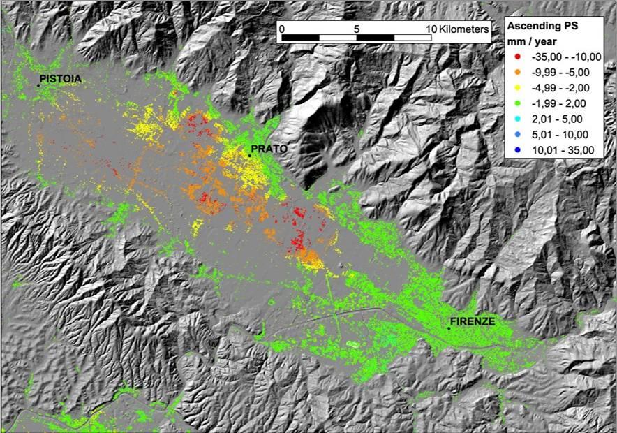
10 The Firenze-Prato-Pistoia plain

11 The Lucca plain Lucca Arno river Arno river
12 Land subsidence during Legend Displacement rate (mm/year) Lucca Porcari Arno river Bientina Dataset: 85 ERS1/ERS2 scenes PS analysis

13 Land subsidence during Legend Displacement rate (mm/year) Lucca Porcari Dataset: 30 Radarsat scenes PS analysis Arno river Bientina
 Red sands, conglomerates (Med. Pleistocene) m (a.s.l) Conglomerates and gravels (Villafranchian) Sandstones (Pliocene) Methamorphic bedrock (Trias) Faults Uncertain faults")
14 Geological setting W E Alluvial terrains: clays and silts (Holocene) Alluvial terrains: sands (Upper Pleistocene-Holocene) Gravels and sands (Med. Pleistocene) Red sands, conglomerates (Med. Pleistocene) m (a.s.l) Conglomerates and gravels (Villafranchian) Sandstones (Pliocene) Methamorphic bedrock (Trias) Faults Uncertain faults


15 Land subsidence effects Bridge over the Rio Ponticelli Power line pile
")
16 Comparison with topographic leveling Available topographic measurements during (about 25 benchmarks) leveling
 Topographic lev.")
17 Comparison with topographic leveling Legend PS ( 95-96) vertical displacement (mm) Topographic lev. ( 95-96) vertical displacement (mm)
18 Comparison with topographic leveling 12 10,86; 10,66 Displacement Spostamento PS (mm) PS (mm) R 2 = 0,96 5,60; 5,54 5,90; 5,82 3,50; 4,82 5,20; 4,78 3,80; 4,11 3,60; 3,73 7,80; 7,78 9,50; 10,02 8,00; 7,06 10,40; 9,64 Residuals Residui (mm) ,08-0,02-0,94-0,42 0,31-0,06-0,76-0,20 1,32 0,52 0,13-0,11 0, ,60; 1,49-3 0,40; 0, Displacement leveling (mm) Spostamento caposaldi (mm) Cross-correlation Punti di misura Measurements Residuals

 Main contour lines (5 m) Contour lines (1 m)")
19 3D scheme of the Porcari area Subsidence map ( ) (mm/year) boreholes Piezometric levels 10/1992 (m a.s.l.) Main contour lines (5 m) Contour lines (1 m) Piezometric levels 11/2001 (m ) Difference ( ) (m ) Thickness of compressible terrains Contour lines (1 m)
20 Cross section of the Porcari area Height (m a.s.l.) Velocity (mm/year) Distance (km) Clay and silt Sand and gravel
21 Geotechnical analysis sforzi efficaci (kn/m 2 ) Profondità (m p.c.) log σ σ in σ fi Above groundwater level σ p e σ in = log σ σ fi n σ p Camp. C3 Compressibility behavoir of the terrain from oedometric tests Assessment of the terrain preconsolidation pressure and the tensional history 9 e n Camp. C4 10 pressione di preconsolidazione sforzi eff. iniziali sforzi eff. finali Borehole S5 plastic conditions elastic conditions Borehole S3 Profondità (m p.c.) above log σ 1 groundwater σ p 2 level σ Camp. C1 in σ fi = 3 n e 4 Camp. C2 5 log σ 6 σ p sforzi efficaci (kn/m 2 ) sforzi eff. iniziali pressione di preconsolidazione sforzi eff. finali e σ inσ fi n Camp. C4
 (mm/year) borehole")
 Piezometric levels 10/1992 Piezometric levels")
22 3D scheme of the Bientina area Subsidence map ( ) (mm/year) boreholes (m a.s.l.) Piezometric levels 10/1992 Piezometric levels 11/2002 Contour lines (1 m) (m ) Difference ( )
23 3D scheme of the Bientina area 135/S3 BS3 (2.1 km) S5 (4.1 km) S4 (7.2 km) MVP (9.4 km) S01 COOP (12.5 km) (11.1 km) S1 (11.4 km) Quota Height (m s.l.m.) (m a.s.l.) ?? Velocità Velocity (mm/year) (mm/anno) Distance Distanza (km)? -20 TOPOGRAFIA Topgraphy PIEZO 09/1971 PIEZO 10/2002 DIFF PS Argille Clay and e limi silt Sabbie Sand and gravel
24 Temporal series: displ. vs groundwater Displacement (mm) Water level (m g.l.)
25 Temporal series: displ. vs groundwater Displacement (mm) Water level (m g.l.)
26 Land subsidence risk assessment Conceptual framework: R = H E V Hazard (H) represents the probability that a certain phenomenon of a given intensity* will occur in a certain area within a given time span Exposure (E) is defined as the values of properties exposed at risk Vulnerability (V) is the expected degree of loss for an element at risk as a consequence of a certain event (expressed in percentage) *Intensity represents the severity of the phenomenon, in terms of potential destructive power
27 Land subsidence risk assessment Proposed methodology: Reconnaissance and mapping of elements at risk through digital cartography and land use maps Classification of elements at risk based on their typology and utilization to create exposure classes Definition of the vulnerability for each exposure class as a function of the different intensity of the phenomenon, based on historical records and land user experience Definition of intensity based on the classification of settlement rates obtained from the interpolated PS measurements D = V(I) E, potential worth of losses
28 Land subsidence risk assessment Code Description Exposure Class Vulnerability (% loss) V(I=I0) V(I=I1) V(I=I2) V(I=I3) 201 PUBLIC/SOCIAL/ADMINISTRATIVE BUILDING E INDUSTRIAL/COMMERCIAL BUILDING - FACTORY E RELIGIOUS BUILDING/BELLTOWER/TABERNACLE E BUILDING UNDER CONSTRUCTION E ABANDONED/RUINED BUILDING E POWER STATION/POWER SUBSTATION/POWER SHED E MONUMENT E3-E HOSPITAL COMPLEX E SCHOOL COMPLEX E SPORT FACILITIES E CIVIL COMPLEX E TOLLROAD/HIGHWAY E STATE HIGHWAY/ PROVINCIAL HIGHWAY E PROVINCIAL ROAD E LOCAL ROAD E Hazard (H), evaluated from past records of ground settlement, is 1 (certain event) where today we measured movement, by assuming stationary conditions (of the subsidence causes) for the future

29 Land subsidence risk assessment Subsidence Intensity Hazard Element at risk Vulnerability Exposure
Objectives and hypotheses. Remote sensing: applications for landslide hazard assessment and risk management. Ping Lu (University of Firenze) Methods
 Methods") Topical Workshop Remote sensing: applications for landslide hazard assessment and risk management Ping Lu (University of Firenze) Supervisors: Prof. Nicola Casagli; Prof. Filippo Catani (Unifi) Dr. Veronica
Topical Workshop Remote sensing: applications for landslide hazard assessment and risk management Ping Lu (University of Firenze) Supervisors: Prof. Nicola Casagli; Prof. Filippo Catani (Unifi) Dr. Veronica
Pilot service: Southern Emilia Romagna (Italy)
") Pilot service: Southern Emilia Romagna (Italy) Surface deformation service provider (PSInSAR TM ) Geodetic and optical remote sensing data integration Final user The study area The Southern Emilia-Romagna
Pilot service: Southern Emilia Romagna (Italy) Surface deformation service provider (PSInSAR TM ) Geodetic and optical remote sensing data integration Final user The study area The Southern Emilia-Romagna
DETECTION OF GROUND MOTION IN THE LISBON REGION WITH PERSISTENT SCATTERER INTERFEROMETRY (PSI)
") DETECTION OF GROUND MOTION IN THE LISBON REGION WITH PERSISTENT SCATTERER INTERFEROMETRY (PSI) Sandra HELENO 1, Afonso LOUREIRO 1,2, João FONSECA 1, João MATOS 1, João CARVALHO 3, Geraint COOKSLEY 4, Ana
DETECTION OF GROUND MOTION IN THE LISBON REGION WITH PERSISTENT SCATTERER INTERFEROMETRY (PSI) Sandra HELENO 1, Afonso LOUREIRO 1,2, João FONSECA 1, João MATOS 1, João CARVALHO 3, Geraint COOKSLEY 4, Ana
SAR interferometry Status and future directions. Rüdiger Gens
 SAR interferometry Status and future directions Rüdiger Gens Polarimetric InSAR Polarimetric InSAR InSAR - Status and future directions sensitivity to changes in surface scattering, even in the presence
VALIDATION OF THE PERMANENT SCATTERERS TECHNIQUE IN URBAN AREAS
 VALIDATION OF THE PERMANENT SCATTERERS TECHNIQUE IN URBAN AREAS Alessandro Ferretti, Claudio Prati, Fabio Rocca, Carlo Colesanti Dipartimento di Elettonica e Informazione Politecnico di Milano Piazza L.
Land subsidence induced by groundwater extraction in the Alto Guadalentín aquifer, SE Spain.
 Land subsidence induced by groundwater extraction in the Alto Guadalentín aquifer, SE Spain. Pablo Ezquerro, Marta Béjar-Pizarro, Gerardo Herrera, José A. Fernández Merodo, Roberto Tomás, Carolina Guardiola-Albert,
Innovative Applications of Satellite Interferometry in the Oil&Gas Industry
 Innovative Applications of Satellite Interferometry in the Oil&Gas Industry A. Ferretti (1), G. Falorni (3), F. Novali (1), F. Rocca (2), A. Rucci (2), A. Tamburini (1) (1) Tele-Rilevamento Europa - TRE
Implementation of Multi-Temporal InSAR to monitor pumping induced land subsidence in Pingtung Plain, Taiwan
 Implementation of Multi-Temporal InSAR to monitor pumping induced land subsidence in Pingtung Plain, Taiwan Presenter: Oswald Advisor: Chuen-Fa Ni Date: March 09, 2017 Literature Review Pingtung Plain
LAND SUBSIDENCE MONITORING IN THE LUCCA PLAIN (CENTRAL ITALY) WITH ERS 1/2
 WITH ERS 1/2") LAND SUBSIDENCE MONITORING IN THE LUCCA PLAIN (CENTRAL ITALY) WITH ERS 1/2 Leonardo Disperati (*), Salvatore Virdis (*), Kurt L. Feigl (**) & Andrea Rindinella (*) (*) Università di Siena, Centro di Geotecnologie,
LAND SUBSIDENCE MONITORING IN THE LUCCA PLAIN (CENTRAL ITALY) WITH ERS 1/2 Leonardo Disperati (*), Salvatore Virdis (*), Kurt L. Feigl (**) & Andrea Rindinella (*) (*) Università di Siena, Centro di Geotecnologie,
Assessing the Ground Response to Urbanization in the Fiumicino area by Combining Geological and Geotechnical Data with Satellite InSAR Data
 Assessing the Ground Response to Urbanization in the Fiumicino area by Combining Geological and Geotechnical Data with Satellite InSAR Data P. Mazzanti F. Bozzano, C. Esposito, M. Patti, A. Rocca La Missione
Application of satellite InSAR data for hydrocarbon reservoir monitoring
 Application of satellite InSAR data for hydrocarbon reservoir monitoring A. Tamburini, A. Belson, A. Ferretti, F. Novali TRE Milano, Italy Copyright - Tele-Rilevamento Europa - 2004 Outline SqueeSAR TM
A DInSAR Investigation of the Ground Settlement Time Evolution of Ocean-Reclaimed Lands in Shanghai
 A DInSAR Investigation of the Ground Settlement Time Evolution of Ocean-Reclaimed Lands in Shanghai Dr 3 project Id. 10644 Zhao, Qing 1 ; Pepe, Antonio 2 ; Gao, Wei 1 ; Li, Xiaofeng 3,4 ; Lu, Zhong 5 ;
THE FEASIBILITY AND APPLICATION OF PSI TO DETECT A RANGE OF GROUND AND STRUCTURE MOTION PHENOMENA.
 THE FEASIBILITY AND APPLICATION OF PSI TO DETECT A RANGE OF GROUND AND STRUCTURE MOTION PHENOMENA. Rachel Holley, InSAR Surveying Consultant InSAR Surveying Team Fugro NPA Satellite Mapping Introduction
Integrated geological approach to the study of coastal subsidence in Emilia-Romagna. Luisa PERINI Calabrese Lorenzo, Luciani Paolo, Severi Paolo,
 Integrated geological approach to the study of coastal subsidence in Emilia-Romagna Luisa PERINI Calabrese Lorenzo, Luciani Paolo, Severi Paolo, Subsidence hazard of Emilia-Romagna coastal plain Caputo
Retrieval of the Long Term Ground Settlement of Ocean Reclaimed Land in Shanghai with Multi Platform Time-series InSAR
 Retrieval of the Long Term Ground Settlement of Ocean Reclaimed Land in Shanghai with Multi Platform Time-series InSAR Dr 3 project Id. 10644 Zhao, Qing 1 ; Pepe, Antonio 2 ; Bonano, Manuela 2 ; Gao, Wei
Deformation measurement using SAR interferometry: quantitative aspects
 Deformation measurement using SAR interferometry: quantitative aspects Michele Crosetto (1), Erlinda Biescas (1), Ismael Fernández (1), Ivan Torrobella (1), Bruno Crippa (2) (1) (2) Institute of Geomatics,
International Journal of Greenhouse Gas Control
 International Journal of Greenhouse Gas Control 4 (2010) 928 937 Contents lists available at ScienceDirect International Journal of Greenhouse Gas Control journal homepage: www.elsevier.com/locate/ijggc
Quantitative assessment of natural and anthropogenic land subsidence in oil and gas productive areas: issues and prospects in Italy.
 Quantitative assessment of natural and anthropogenic land subsidence in oil and gas productive areas: issues and prospects in Italy Valerio Comerci All information are publicly available at: Environmental
Advanced interpretation of land subsidence by validating multiinterferometric SAR data: the case study of Anthemountas basin (Northern Greece)
") Revision of paper Advanced interpretation of land subsidence by validating multiinterferometric SAR data: the case study of Anthemountas basin (Northern Greece) By Raspini et al. General comments This
Revision of paper Advanced interpretation of land subsidence by validating multiinterferometric SAR data: the case study of Anthemountas basin (Northern Greece) By Raspini et al. General comments This
Y. Shioi 1, Y. Hashizume 2 and H. Fukada 3
 Y. Shioi 1, Y. Hashizume 2 and H. Fukada 3 1 Emeritus Professor, Hachinohe Institute of Technology, Hachinohe, Japan 2 Chief Engineer, Izumo, Misawa, Aomori, Japan 3 Profesr, Geo-Technical Division, Fudo
Terrafirma monitoring and mapping landslide services for Europe based on InSAR satellite data
 Department of Earth Sciences CENTRE OF COMPETENCE OF THE CIVIL PROTECTION DEPARTMENT PRESIDENCY OF THE COUNCIL OF MINISTERS Terrafirma monitoring and mapping landslide services for Europe based on InSAR
14 Geotechnical Hazards
 Volume 2: Assessment of Environmental Effects 296 14 Geotechnical Hazards Overview This Chapter provides an assessment of the underlying geotechnical conditions to identify: any potential liquefaction
4. Geotechnical and Geological Aspects. 4.1 Geotechnical Aspects
 4. Geotechnical and Geological Aspects 4.1 Geotechnical Aspects A preliminary reconnaissance of the geotechnical conditions of Duzce, Kaynasli, and Bolu urban areas was done during the Turkey Expedition
Radar Remote Sensing: Monitoring Ground Deformations and Geohazards from Space
 Radar Remote Sensing: Monitoring Ground Deformations and Geohazards from Space Xiaoli Ding Department of Land Surveying and Geo-Informatics The Hong Kong Polytechnic University A Question 100 km 100 km
PERSISTENT SCATTERER INTERFEROMETRY: POTENTIAL AND LIMITS
 PERSISTENT SCATTERER INTERFEROMETRY: POTENTIAL AND LIMITS M. Crosetto a, O. Monserrat a, A. Jungner, B. Crippa b a Institute of Geomatics, Av. del Canal Olímpic, s/n, Castelldefels, E-08860, Spain (michele.crosetto,
Evaluation of subsidence from DinSAR techniques using Envisat-ASAR data at Toluca Valley Basin, Mexico.
 Evaluation of subsidence from DinSAR techniques using Envisat-ASAR data at Toluca Valley Basin, Mexico. Norma Angélica Dávila Hernández 1 Delfino Madrigal Uribe 1 Xanat Antonio Némiga 1 1 Autonomous University
Application of PSI technique to slope stability monitoring in the Daunia mountains, Italy
 ESA ESRIN - Frascati 28 November- 2 December Application of PSI technique to slope stability monitoring in the Daunia mountains, Italy F. Bovenga (1) (fabio.bovenga@ba.infn.it) L. Guerriero (1) R. Nutricato
SPATIAL MODELS FOR THE DEFINITION OF LANDSLIDE SUSCEPTIBILITY AND LANDSLIDE HAZARD. J.L. Zêzere Centre of Geographical Studies University of Lisbon
 SPATIAL MODELS FOR THE DEFINITION OF LANDSLIDE SUSCEPTIBILITY AND LANDSLIDE HAZARD J.L. Zêzere Centre of Geographical Studies University of Lisbon CONCEPTUAL MODEL OF LANDSLIDE RISK Dangerous Phenomena
Analysis of mining deformations based on PSInSAR technique case study of the Walbrzych coal mines (Poland)
") Analysis of mining deformations based on PSInSAR technique case study of the Walbrzych coal mines (Poland) Dr. Jan Blachowski, Dr. Wojciech Milczarek Faculty of Geoengineering, Mining and Geology, Wroclaw
Analysis of mining deformations based on PSInSAR technique case study of the Walbrzych coal mines (Poland) Dr. Jan Blachowski, Dr. Wojciech Milczarek Faculty of Geoengineering, Mining and Geology, Wroclaw
EXTENSION OF A HOTEL IN POIANA BRASOV ON AN INCLINED SLOPE
 Bulletin of the Transilvania University of Braşov Vol. 9 (58) - 2016 Series I: Engineering Sciences EXTENSION OF A HOTEL IN POIANA BRASOV ON AN INCLINED SLOPE M. MĂNTULESCU 1 I. TUNS 2 Abstract: Extension
Continuous Risk Assessment of Structures and Plants in Areas of Ground Deformation Susceptibility by Space-based SAR/ASAR Interferometry
 CCN4 Project Continuous Risk Assessment of Structures and Plants in Areas of Ground Deformation Susceptibility by Space-based SAR/ASAR Interferometry Issaak Parcharidis*, Michael Foumelis and Penelope
APPLICABILITY OF PSINSAR FOR BUILDING HAZARD IDENTIFICATION
 APPLICABILITY OF PSINSAR FOR BUILDING HAZARD IDENTIFICATION. STUDY OF THE 29 JANUARY 2006 KATOWICE EXHIBITION HALL COLLAPSE AND THE 24 FEBRUARY 2006 MOSCOW BASMANNY MARKET COLLAPSE Zbigniew Perski (1),
Terrafirma Extension Tectonic Theme. 6 th Terrafirma Workshop ESA-ESRIN, December 1st, 2010
 Terrafirma Extension Tectonic Theme 6 th Terrafirma Workshop ESA-ESRIN, December 1st, 2010 Summary - Service Prospectus Presentation - The Terrafirma Extension Tectonic Theme (TFX-TT) - Greek Task Force
LEVEL II SEISMIC MICROZONING IN THE SAN GIMIGNANO AREA (CENTRAL ITALY)
") European Congress on Regional Geoscientific Cartography and Information system Bologna 12-15 June 2012 LEVEL II SEISMIC MICROZONING IN THE SAN GIMIGNANO AREA (CENTRAL ITALY) D. Albarello, M. Coltorti,
European Congress on Regional Geoscientific Cartography and Information system Bologna 12-15 June 2012 LEVEL II SEISMIC MICROZONING IN THE SAN GIMIGNANO AREA (CENTRAL ITALY) D. Albarello, M. Coltorti,
Land subsidence due to groundwater withdrawal in Hanoi, Vietnam
 Land Subsidence (Proceedings of the Fifth International Symposium on Land Subsidence, The Hague, October 1995). 1AHS Publ. no. 234, 1995. 55 Land subsidence due to groundwater withdrawal in Hanoi, Vietnam
P079 First Results from Spaceborne Radar Interferometry for the Study of Ground Displacements in Urban Areas SUMMARY
 P079 First Results from Spaceborne Radar Interferometry for the Study of Ground Displacements in Urban Areas C.M. Crosetto (Instituto de Geomatica), C.A. Casas (University of Barcelona), R.G. Ranieri (University
DIFFERENTIAL INSAR STUDIES IN THE BOREAL FOREST ZONE IN FINLAND
 DIFFERENTIAL INSAR STUDIES IN THE BOREAL FOREST ZONE IN FINLAND Kirsi Karila (1,2), Mika Karjalainen (1), Juha Hyyppä (1) (1) Finnish Geodetic Institute, P.O. Box 15, FIN-02431 Masala, Finland, Email:
InSAR techniques and applications for monitoring landslides and subsidence
 Geoinformation for European-wide Integration, Benes (ed.) 2003 Millpress, Rotterdam, ISBN 90-77017-71-2 InSAR techniques and applications for monitoring landslides and subsidence H. Rott & T. Nagler Institut
THE USE OF DIFFERENT REMOTE SENSING TECHNIQUES FOR LANDSLIDE CHARACTERIZATION
 THE USE OF DIFFERENT REMOTE SENSING TECHNIQUES FOR LANDSLIDE CHARACTERIZATION Ph.D. candidate: ANNA DE AGOSTINI Tutor: Dr. M. FLORIS Cycle: XXVI Abstract The aim of my research is to investigate the potential
Studio delle Proprietà Geotecniche e del Comportamento Dinamico dell Alta Valle del Crati nell Area Urbana di Cosenza
 Trieste, 17-19 Novembre 2015 Studio delle Proprietà Geotecniche e del Comportamento Dinamico dell Alta Valle del Crati nell Area Urbana di Cosenza Maurizio Piersanti 1, A. Caserta 2, G. Galli 1, G. Carlucci
Retrieving 3D deformation pattern of a landslide with hiresolution InSAR and in-situ measurements: Just landslide case-study
 Retrieving 3D deformation pattern of a landslide with hiresolution InSAR and in-situ measurements: Just landslide case-study Zbigniew Perski (1), Petar Marinković (2), Yngvar Larsen (3), Tomasz Wojciechowski
EO Information Services in support of Satellite Tools for Building Flood Defence Systems in Guyana
 EO Information Services in support of Satellite Tools for Building Flood Defence Systems in Guyana F. N. Koudogbo and A. Arnaud Altamira Information J. Leen, Eurosense World Bank HQ, Washington DC Date
Geo-hazard Potential Mapping Using GIS and Artificial Intelligence
 Geo-hazard Potential Mapping Using GIS and Artificial Intelligence Theoretical Background and Uses Case from Namibia Andreas Knobloch 1, Dr Andreas Barth 1, Ellen Dickmayer 1, Israel Hasheela 2, Andreas
Hendra Pachri, Yasuhiro Mitani, Hiro Ikemi, and Ryunosuke Nakanishi
 21 2nd International Conference on Geological and Civil Engineering IPCBEE vol. 8 (21) (21) IACSIT Press, Singapore DOI: 1.7763/IPCBEE. 21. V8. 2 Relationships between Morphology Aspect and Slope Failure
Improved PSI Performance for Landslide Monitoring Applications. J. Duro, R. Iglesias, P. Blanco-Sánchez, F. Sánchez and D. Albiol
 Improved PSI Performance for Landslide Monitoring Applications J. Duro, R. Iglesias, P. Blanco-Sánchez, F. Sánchez and D. Albiol Outline Area of Study Previous PSI (and others) studies Main conclusions
Proceedings e report 78
 Proceedings e report 78 ADVANCED TERRAIN MAPPING OF THE GIOIA TAURO PLAIN CALABRIA REGION, ITALY ESA GMES TERRAFIRMA Edited by Federico Raspini Francesca Cigna Sandro Moretti Nicola Casagli Firenze University
GEOTECHNICAL ENGINEERING INVESTIGATION HANDBOOK Second Edition
 GEOTECHNICAL ENGINEERING INVESTIGATION HANDBOOK Second Edition Roy E. Hunt Taylor & Francis Taylor & Francis Croup Boca Raton London New York Singapore A CRC title, part of the Taylor & Francis imprint,
Ground deformation monitoring at the Phlegrean Fields (Naples, Italy) from the exploitation of SAR data in the framework of CAT-1 and DUP activities
 from the exploitation of SAR data in the framework of CAT-1 and DUP activities") Ground deformation monitoring at the Phlegrean Fields (Naples, Italy) from the exploitation of SAR data in the framework of CAT-1 and DUP activities Borgström S., Aquino I., Del Gaudio C., Ricco C., Siniscalchi
Ground deformation monitoring at the Phlegrean Fields (Naples, Italy) from the exploitation of SAR data in the framework of CAT-1 and DUP activities Borgström S., Aquino I., Del Gaudio C., Ricco C., Siniscalchi
Project S4: ITALIAN STRONG MOTION DATA BASE. Deliverable # D3. Definition of the standard format to prepare descriptive monographs of ITACA stations
 Agreement INGV-DPC 2007-2009 Project S4: ITALIAN STRONG MOTION DATA BASE Responsibles: Francesca Pacor, INGV Milano Pavia and Roberto Paolucci, Politecnico Milano http://esse4.mi.ingv.it Deliverable #
TERRAFIRMA 6 th USER WORKSHOP. Use of displacement space measurements in geotechnical engineering: Application at Thessaly plain
 TERRAFIRMA 6 th USER WORKSHOP Greek group: Stamatopoulos and Associates Ltd. Harokopio University of Athens Use of displacement space measurements in geotechnical engineering: Application at Thessaly plain
GNS Science, Lower Hutt, New Zealand NZSEE Conference
 A Ground Shaking Amplification Map for New Zealand U. Destegul, G. Dellow & D. Heron GNS Science, Lower Hutt, New Zealand. 2008 NZSEE Conference ABSTRACT: A ground shaking amplification map of New Zealand
V S and N SPT Measures for Seismic Characterization of Soils
 V S and Measures for Seismic Characterization of Soils 218 Giovanna Vessia, Mario Luigi Rainone, and Patrizio Signanini Abstract Seismic classification of soils for designing purposes can be addressed
Guidelines for Site-Specific Seismic Hazard Reports for Essential and Hazardous Facilities and Major and Special-Occupancy Structures in Oregon
 Guidelines for Site-Specific Seismic Hazard Reports for Essential and Hazardous Facilities and Major and Special-Occupancy Structures in Oregon By the Oregon Board of Geologist Examiners and the Oregon
MODELS TO PREDICT PERSISTENT SCATTERERS DATA DISTRIBUTION AND THEIR CAPACITY TO REGISTER MOVEMENT ALONG THE SLOPE
 MODELS TO PREDICT PERSISTENT SCATTERERS DATA DISTRIBUTION AND THEIR CAPACITY TO REGISTER MOVEMENT ALONG THE SLOPE Notti D., (1) Meisina C. (1), Zucca F. (1) and Colombo A. (2) (1) Dip. Di Scienze della
Maurizio Monina S.E.L.I Spa, Rome, Italy. Remo Grandori S.E.L.I Spa, Rome, Italy. Aristodemo Busillo S.E.L.I Spa, Rome, Italy
 HIGH PRESSURE EPB TUNNELING UNDER SENSITIVE BUILDINGS Maurizio Monina S.E.L.I Spa, Rome, Italy Remo Grandori S.E.L.I Spa, Rome, Italy Aristodemo Busillo S.E.L.I Spa, Rome, Italy Andrea Sciotti Roma Metropolitane,
COASTAL QUATERNARY GEOLOGY MAPPING FOR NSW: EXAMPLES AND APPLICATIONS
 COASTAL QUATERNARY GEOLOGY MAPPING FOR NSW: EXAMPLES AND APPLICATIONS A Troedson Geological Survey of New South Wales Abstract Detailed geological mapping of the coastal plains of regional NSW was undertaken
ENGINEER S CERTIFICATION OF FAULT AREA DEMONSTRATION (40 CFR )
") PLATTE RIVER POWER AUTHORITY RAWHIDE ENERGY STATION BOTTOM ASH TRANSFER (BAT) IMPOUNDMENTS LARIMER COUNTY, CO ENGINEER S CERTIFICATION OF FAULT AREA DEMONSTRATION (40 CFR 257.62) FOR COAL COMBUSTION RESIDUALS
PLATTE RIVER POWER AUTHORITY RAWHIDE ENERGY STATION BOTTOM ASH TRANSFER (BAT) IMPOUNDMENTS LARIMER COUNTY, CO ENGINEER S CERTIFICATION OF FAULT AREA DEMONSTRATION (40 CFR 257.62) FOR COAL COMBUSTION RESIDUALS
Monitoring long-term ground movements and Deep Seated Gravitational
 Monitoring long-term ground movements and Deep Seated Gravitational Slope Deformations by InSAR time series: cases studies in Italy Salvatore Stramondo (1), M. Saroli (1, 2), M. Moro (1, 2), S. Atzori
3.12 Geology and Topography Affected Environment
 3 Affected Environment and Environmental Consequences 3.12 Geology and Topography 3.12.1 Affected Environment 3.12.1.1 Earthquakes Sterling Highway MP 45 60 Project Draft SEIS The Kenai Peninsula is predisposed
Multi-temporal archaeological and environmental prospection in Nasca (Peru) with ERS-1/2, ENVISAT and Sentinel-1A C-band SAR data
 with ERS-1/2, ENVISAT and Sentinel-1A C-band SAR data") 12-13 November 215 ESA-ESRIN, Frascati (Rome), Italy Day 1 Session: Historical Landscapes and Environmental Analysis Multi-temporal archaeological and environmental prospection in Nasca (Peru) with ERS-1/2,
12-13 November 215 ESA-ESRIN, Frascati (Rome), Italy Day 1 Session: Historical Landscapes and Environmental Analysis Multi-temporal archaeological and environmental prospection in Nasca (Peru) with ERS-1/2,
Talić Z. et al: Geotechnical characteristics... Archives for Technical Sciences 2014, 11(1), 33-39
, 33-39") Review paper UDC: 624.131.537 DOI: 10.7251/afts.2014.0611.033T COBISS.RS-ID 4572184 GEOTECHNICAL CHARACTERISTICS OF THE TERRAIN AND CALCULATION OF BEARING CAPACITY FOR BRIDGE No. 1 OF MOTORWAY LAŠVA DONJI
Review paper UDC: 624.131.537 DOI: 10.7251/afts.2014.0611.033T COBISS.RS-ID 4572184 GEOTECHNICAL CHARACTERISTICS OF THE TERRAIN AND CALCULATION OF BEARING CAPACITY FOR BRIDGE No. 1 OF MOTORWAY LAŠVA DONJI
SAR Monitoring of Progressive and Seasonal Ground Deformation Using the Permanent Scatterers Technique
 IEEE TRANSACTIONS ON GEOSCIENCE AND REMOTE SENSING, VOL. 41, NO. 7, JULY 2003 1685 SAR Monitoring of Progressive and Seasonal Ground Deformation Using the Permanent Scatterers Technique Carlo Colesanti,
GEOLOGY AND SOILS. This chapter summarizes geologic and geotechnical aspects of the site as they relate to the Project.
 9 GEOLOGY AND SOILS INTRODUCTION This chapter summarizes geologic and geotechnical aspects of the site as they relate to the Project. This chapter utilizes information from the following reports prepared
IAEA SAFETY STANDARDS Geotechnical Aspects of Site Evaluation and Foundations in NPPs, NS-G-3.6
 IAEA SAFETY STANDARDS Geotechnical Aspects of Site Evaluation and Foundations in NPPs, NS-G-3.6 Regional Workshop on Volcanic, Seismic, and Tsunami Hazard Assessment Related to NPP Siting Activities and
Liquefaction Susceptibility of Pleistocene Aged Wellington Alluvium Silt
 6 th International Conference on Earthquake Geotechnical Engineering 1-4 November 2015 Christchurch, New Zealand Liquefaction Susceptibility of Pleistocene Aged Wellington Alluvium Silt E. P. Torvelainen
PSI analysis of ground deformations along the south-western coast of the Gulf of Gdansk (Poland)
") FRINGE 2009 WORKSHOP, Advances in the Science and Applications of SAR Interferometry 30 November 4 December 2009 ESA-ESRIN Frascati, Italy PSI analysis of ground deformations along the south-western coast
FRINGE 2009 WORKSHOP, Advances in the Science and Applications of SAR Interferometry 30 November 4 December 2009 ESA-ESRIN Frascati, Italy PSI analysis of ground deformations along the south-western coast
PERSISTENT SCATTERER SAR INTERFEROMETRY APPLICATIONS ON LANDSLIDES IN CARPATHIANS (SOUTHERN POLAND)
") Acta Geodyn. Geomater., Vol. 7, No. 3 (159), 1 7, 2010 PERSISTENT SCATTERER SAR INTERFEROMETRY APPLICATIONS ON LANDSLIDES IN CARPATHIANS (SOUTHERN POLAND) Zbigniew PERSKI 1) *, Tomasz WOJCIECHOWSKI 1)
Acta Geodyn. Geomater., Vol. 7, No. 3 (159), 1 7, 2010 PERSISTENT SCATTERER SAR INTERFEROMETRY APPLICATIONS ON LANDSLIDES IN CARPATHIANS (SOUTHERN POLAND) Zbigniew PERSKI 1) *, Tomasz WOJCIECHOWSKI 1)
High-resolution temporal imaging of. Howard Zebker
 High-resolution temporal imaging of crustal deformation using InSAR Howard Zebker Stanford University InSAR Prehistory SEASAT Topographic Fringes SEASAT Deformation ERS Earthquake Image Accurate imaging
International Conference Analysis and Management of Changing Risks for Natural Hazards November 2014 l Padua, Italy
 Abstract code: AP5 Mapping direct and indirect fluvial hazard in the Middle Calore River valley (southern Italy) P. Magliulo 1, A. Valente 1 1 Dipartimento di Scienze e Tecnologie, Università degli Studi
TEMPORAL VARIABILITY OF ICE FLOW ON HOFSJÖKULL, ICELAND, OBSERVED BY ERS SAR INTERFEROMETRY
 TEMPORAL VARIABILITY OF ICE FLOW ON HOFSJÖKULL, ICELAND, OBSERVED BY ERS SAR INTERFEROMETRY Florian Müller (1), Helmut Rott (2) (1) ENVEO IT, Environmental Earth Observation GmbH, Technikerstrasse 21a,
Dr. Simon Plank. German Remote Sensing Data Center (DFD), German Aerospace Center (DLR)
, German Aerospace Center (DLR)") Pre-survey suitability analysis of the differential and persistent scatterer synthetic ti aperture radar interferometry t method for deformation monitoring of landslides Dr. Simon Plank German Remote Sensing
Pre-survey suitability analysis of the differential and persistent scatterer synthetic ti aperture radar interferometry t method for deformation monitoring of landslides Dr. Simon Plank German Remote Sensing
Hydrogeological Studies and Mapping on West Milan Area
 Hydrogeological Studies and Mapping on West Milan Area R.Bergamo, W.Danieli, D.de Bartolo, A.P.Gatti ARPA Lombardia, Dipartimento di Milano 1, Area di Tutela Ambientale Via Spagliardi 19, 20015 Parabiago
Geology 1:50,000 Maps Legends
 Geology 1:50,000 s Legends MGR WGR WMGR LSGR rtificial Ground and Landslip Made Ground (Undivided) Worked Ground (Undivided) Infilled Ground Landscaped Ground (Undivided) rtificial Deposit Void rtificial
Geotechnical Site Classification and Croatian National Annex for EC 8
 Geotechnical Site Classification and Croatian National Annex for EC 8 by Predrag Kvasnika University of Zagreb Faculty of Mining-Geology and Petroleum engineering Outline General Motivation Site classification
SURFACE GEOLOGY AND LIQUEFACTION SUSCEPTIBILITY IN THE INNER RIO GRANDE VALLEY NEAR ALBUQUERQUE, NEW MEXICO
 SURFACE GEOLOGY AND LIQUEFACTION SUSCEPTIBILITY IN THE INNER RIO GRANDE VALLEY NEAR ALBUQUERQUE, NEW MEXICO Keith I. Kelson, Christopher S. Hitchcock, and Carolyn E. Randolph William Lettis & Associates,
EO, Land Motion and Climate Adaptation in Mediterranean Cities June 2014, Athens
 EO, Land Motion and Climate Adaptation in Mediterranean Cities 10-11 June 2014, Athens 1 Context UN Report: Water and Cities Facts and Figures 2 Context UN Report: Water and Cities Facts and Figures 3
General Geologic Setting and Seismicity of the FHWA Project Site in the New Madrid Seismic Zone
 General Geologic Setting and Seismicity of the FHWA Project Site in the New Madrid Seismic Zone David Hoffman University of Missouri Rolla Natural Hazards Mitigation Institute Civil, Architectural & Environmental
Applying Hazard Maps to Urban Planning
 Applying Hazard Maps to Urban Planning September 10th, 2014 SAKAI Yuko Disaster Management Expert JICA Study Team for the Metro Cebu Roadmap Study on the Sustainable Urban Development 1 Contents 1. Outline
Lecture 15: Subsidence
 Lecture 15: Subsidence Key Questions 1. How does removal of groundwater cause subsidence on a regional scale? 2. Under what conditions does a building sink into sediment? 3. Why do clays consolidate more
DRILLED DISPLACMENT PILE PERFORMANCE IN COASTAL PLAIN AND RESIDUAL SOILS
 DRILLED DISPLACMENT PILE PERFORMANCE IN COASTAL PLAIN AND RESIDUAL SOILS Presented by: W. Morgan NeSmith, P.E. Berkel & Company Contractors Inc. 770.941.5100 mnesmith@berkelapg.com SC Engineering Conference
Monitoring Natural Slopes and Man-made Structures by TInSAR: Understanding Behavior and Forecasting Method
 Monitoring Natural Slopes and Man-made Structures by TInSAR: Understanding Behavior and Forecasting Method P. Mazzanti & F. Bozzano NHAZCA S.r.l., Spin off Company of Sapienza University of Rome, Italy
A MULTI-CRITERIA APPROACH SUPPORTING THE INVESTIGATION OF A FLOODPLAIN POTENTIALLY CONTAMINATED BY PESTICIDES
 A MULTI-CRITERIA APPROACH SUPPORTING THE INVESTIGATION OF A FLOODPLAIN POTENTIALLY CONTAMINATED BY PESTICIDES L ZILIANI, B GROPPELLI, S CECCON, F COLOMBO (RAMBOLL ENVIRON) D BOCCHIOLA, M C RULLI, G RAVAZZANI,
PROBABILISTIC LIQUEFACTION HAZARD ANALYSIS IN JAPAN
 SECED 2015 Conference: Earthquake Risk and Engineering towards a Resilient World 9-10 July 2015, Cambridge UK PROBABILISTIC LIQUEFACTION HAZARD ANALYSIS IN JAPAN Tetsushi KURITA 1 and Sei ichiro FUKUSHIMA
G. Ventura* a, Vilardo G. b, V. Sepe a. Napoli, Italy, INTRODUCTION ABSTRACT
 Monitoring and structural significance of ground deformations at Campi Flegrei supervolcano (Italy) from the combined 2D and 3D analysis of PS-InSAR, geophysical, geological and structural data G. Ventura*
A PROBABILISTIC APPROACH FOR CHARACTERIZING THE COMPLEX GEOLOGIC ENVIRONMENT FOR DESIGN OF THE NEW METRO DO PORTO
 AITES-ITA 2001 World Tunnel Congress PROGRESS IN TUNNELING AFTER 2000 Milano, June 10-13, 2001 Volume III, pp. 463-470 A PROBABILISTIC APPROACH FOR CHARACTERIZING THE COMPLEX GEOLOGIC ENVIRONMENT FOR DESIGN
Combining InSAR, Levelling and GNSS for the Estimation of 3D Surface Displacements
 Combining InSAR, Levelling and GNSS for the Estimation of 3D Surface Displacements Thomas Fuhrmann (1), Miguel Caro Cuenca (2), Freek van Leijen (3), Malte Westerhaus (1), Ramon Hanssen (3), Bernhard Heck
Analysis of Land Subsidence (Land Subsidence) Affects Against Water Puddle In Semarang City
 Affects Against Water Puddle In Semarang City") Proceedings of International Conference : Problem, Solution and Development of Coastal and Delta Areas Semarang, Indonesia September 26th, 2017 Paper No. C-22 Analysis of ( ) Affects Against Water Puddle
Proceedings of International Conference : Problem, Solution and Development of Coastal and Delta Areas Semarang, Indonesia September 26th, 2017 Paper No. C-22 Analysis of ( ) Affects Against Water Puddle
Prevention and remediation of rockslide at left portal of north tunnel of Da Nang Qu ang Ngai expressway in Quang Nam, Vietnam
 IOP Conference Series: Earth and Environmental Science PAPER OPEN ACCESS Prevention and remediation of rockslide at left portal of north tunnel of Da Nang Qu ang Ngai expressway in Quang Nam, Vietnam To
The Safety project: Updating geohazard activity maps with Sentinel-1data
 The Safety project: Updating geohazard activity maps with Sentinel-1data Oriol Monserrat a, Safety Consortium a Centre Tecnològic de Telecomunicacions de Catalunya (CTTC/CERCA), Division of Geomatics,
Site characterization for the HZM immersed tunnel
 DGF 2013-09-12 (18 th ICSMGE Paris; Discussion Session TC102) Site characterization for the HZM immersed tunnel HKSAR Jørgen S. Steenfelt COWI, Denmark Co-authors: S. Yding, A. Rosborg, J.G. Hansen, R.
Subsidence Monitoring in Hampton Roads Using Satellites
 ODU Digital Commons July 29, 2016: The Latest in Sea Level Rise Science Hampton Roads Sea Level Rise/Flooding Adaptation Forum 7-29-2016 Subsidence Monitoring in Hampton Roads Using Satellites Ben Hamlington
Castaldo R. (1) De Novellis V. (1) Lollino P. (2) Manunta M. (1) Tizzani P. (1) 1: IREA-CNR, Napoli, Italy. 2: IRPI-CNR, Bari, Italy.
 De Novellis V. (1) Lollino P. (2) Manunta M. (1) Tizzani P. (1) 1: IREA-CNR, Napoli, Italy. 2: IRPI-CNR, Bari, Italy.") Advanced Numerical Modelling for Slow Landslide Analyses through the Effective Integration of SBAS-DInSAR and in situ Observations: the Case Study of Ivancich Landslide (Assisi, Italy) Castaldo R. (1)
Advanced Numerical Modelling for Slow Landslide Analyses through the Effective Integration of SBAS-DInSAR and in situ Observations: the Case Study of Ivancich Landslide (Assisi, Italy) Castaldo R. (1)
Ground deformation in Thessaly, Central Greece, between 1992 and 2000 by means of ERS multi-temporal InSAR
 INGV Ground deformation in Thessaly, Central Greece, between 1992 and 2000 by means of ERS multi-temporal InSAR S. Atzori (1), C. Tolomei (1), S. Salvi (1), A. Ganas (2), S. Stramondo (1) and L. Colini
Subsidence and associated shallow faulting hazard assessment in central Mexico using InSAR and GPS.
 Subsidence and associated shallow faulting hazard assessment in central Mexico using InSAR and GPS. E. Cabral-Cano, Instituto de Geofísica, UNAM D. Solano-Rojas, Univ. of Miami-RSMAS T. Oliver-Cabrera
ESA GMES: Terrafirma S3: Service Prospectus V4.4 June 2013 GMES TERRAFIRMA. ESRIN/Contract no / 05 / I-EC. S3: Service Prospectus
 GMES TERRAFIRMA ESRIN/Contract no. 19366 / 05 / I-EC S3: Service Prospectus Version 4.4 June 14 th 2013 Geraint Cooksley, Chris Bremmer, Salvatore Stramondo & Gaia Righini Reviewed by: Project Manager
LIQUEFACTION INDUCED GROUND FAILURES CAUSED BY STRONG GROUND MOTION
 Paper No. ASOLE LIQUEFACTION INDUCED GROUND FAILURES CAUSED BY STRONG GROUND MOTION Wei F. LEE 1, Kenji ISHIHARA 2, Cheng Hsin CHEN 3, B. L. Chu 4 ABSTRACT During the 1999 Chi-Chi earthquake, a site named
IV. ENVIRONMENTAL IMPACT ANALYSIS E. GEOLOGY AND SOILS
 IV. ENVIRONMENTAL IMPACT ANALYSIS E. GEOLOGY AND SOILS INTRODUCTION This section evaluates potential impacts related to geology, including seismicity, and soils associated with development of the proposed
SEISMIC ZONING FOR GROUND MOTION IN TOKYO BASED ON NATION-WIDE ELECTRIC GEOTECHNICAL DATABASE SYSTEM
 Paper No. SZGWA SEISMIC ZONING FOR GROUND MOTION IN TOKYO BASED ON NATION-WIDE ELECTRIC GEOTECHNICAL DATABASE SYSTEM Susumu YASUDA 1, Hirokazu WATANABE 2, Mozomu YOSHIDA 3 ABSTRACT Representative soil
Università di Roma La Sapienza, Facoltà d Ingegneria, Dipartimento di Idraulica,Trasporti e Strade (D.I.T.S.) 00185, Roma, Italy
 00185, Roma, Italy") DORIS FP7-EU PROJECT: EXPLOITATION OF 20 YEARS DINSAR DATA ARCHIVE FOR LANDSLIDE MONITORING Manunta M. (1), Calò F. (1), Paglia L., (1), Bonano M. (1,2), Lanari R. (1) (1) IREA-CNR, Via Diocleziano 328,
DORIS FP7-EU PROJECT: EXPLOITATION OF 20 YEARS DINSAR DATA ARCHIVE FOR LANDSLIDE MONITORING Manunta M. (1), Calò F. (1), Paglia L., (1), Bonano M. (1,2), Lanari R. (1) (1) IREA-CNR, Via Diocleziano 328,
Background Unified Mapping Project of NAMRIA Mapping of Typhoon-Affected Areas Final Output Conclusion
 www.namria.gov.ph Background Unified Mapping Project of NAMRIA Mapping of Typhoon-Affected Areas Final Output Conclusion Typhoon Haiyan (local name Yolanda) the deadliest most destructive typhoon in recorded