Continuous Risk Assessment of Structures and Plants in Areas of Ground Deformation Susceptibility by Space-based SAR/ASAR Interferometry
|
|
|
- Amber Fields
- 5 years ago
- Views:
Transcription
1 CCN4 Project Continuous Risk Assessment of Structures and Plants in Areas of Ground Deformation Susceptibility by Space-based SAR/ASAR Interferometry Issaak Parcharidis*, Michael Foumelis and Penelope Kourkouli Harokopio University of Athens Dep. of Geography ESRIN, Terrafirma phase 5th User Workshop 25-26/03/2009

2 Harokopio University of Athens/Faculty of Geography Scientific Coordinator: Dr. Issaak Parcharidis Subcontractors: University of Athens/Dep. of Geophysics and Geothermics Metrica S.A. GAMMA Remote Sensing (Switzerland) ESRIN, Terrafirma phase 5th User Workshop 25-26/03/2009

3 As pilot application the new bridge Rio-Antirio (Western Greece), an important infrastructure and its environment, was selected for monitoring and assessment. ESRIN, Terrafirma phase 5th User Workshop 25-26/03/2009
 producing deformation history charts for predefined prioritized point targets on the bridge as well as for the")
4 The main objectives of the project are : (i) mapping of past deformation (spanning over more than 15 years of archive data) (ii) Continuous monitoring, according to the revisit period of the satellite, attempting to create a regular updating of displacement maps (iii) producing deformation history charts for predefined prioritized point targets on the bridge as well as for the surrounding area showing not only the rate of deformation but also its temporal variation (iv) assessment of an operational use of the proposed technique and methodology and (v) estimation of the operating cost and comparison with ground techniques. ESRIN, Terrafirma phase 5th User Workshop 25-26/03/2009
 through the harbors of")

5 The Rio-Antirio bridge is located at the intersection of two major roads: the Patras - Athens - Thessaloniki motorway which links the three most important cities of Greece and forms part of the European motorway network The bridge facilitates communication between Greece and Italy (and thus Western Europe) through the harbors of Patras and Igoumenitsa. The effects of the bridge change the revenue and work conditions of the adjacent areas and the conditions of social exclusion The Bridge plays a large role in the development, as an axis linking Greece to Europe, the Mediterranean and the Middle East ESRIN, Terrafirma phase 5th User Workshop 25-26/03/2009

6 The Rio Antirio Bridge is the longest multi-span cable stayed bridge of the World with its 2,252 meters deck Its foundations lay on a seabed that reaches 65 meters of depth. This is a world record for a bridge as well as their diameter of 90 meters making of them the world s largest bridge foundations. The Bridge has been awarded 9 International Awards by the international scientific community ESRIN, Terrafirma phase 5th User Workshop 25-26/03/2009

7 The Rio-Antirio bridge is built to withstand a collision of : tons tanker, wind speed of 250 km per hour and over 7 Richter scale earthquake Absorbing up to 2 meters displacement between any of its piers, the bridge is one of the safest places to be, should a major earthquake happen in the Patras area. ESRIN, Terrafirma phase 5th User Workshop 25-26/03/2009

8 The area of the Rio-Antirio strait presents a combination of hazards like : absence of stiff seabed strong seismic activity tectonic movements which make the area of great ground deformation susceptibility and the bridge an element in risk. ESRIN, Terrafirma phase 5th User Workshop 25-26/03/2009

9 ESRIN, Terrafirma phase 5th User Workshop 25-26/03/2009 The seabed profile presents steep slopes on each side and a long horizontal plateau about 60 meters below sea level. No bedrock has been encountered during investigations down to a depth of 100 meters below seabed. Based on a geological study, it is believed that the thickness of sediments made of thick layers of clay mixed in some areas with fine sand and silt is greater than 500 meters.

10 Seismicity during 2008 ESRIN, Terrafirma phase 5 th User Workshop 25-26/03/2009

11 Geological map of the area ESRIN, Terrafirma phase 5 th User Workshop 25-26/03/2009

12 Ground motion is the surface expression of different physical events like subsidence, earthquakes, landslides etc. In many cases the deformation is of anthropogenic cause related to water and oil pumping, slopes undercut by roads, mining etc. Construction and operation of engineering structures and generally of big projects in urban or in rural areas can be seriously affected by ground conditions leading to casualties and financial losses ESRIN, Terrafirma phase 5 th User Workshop 25-26/03/2009
13 The proposal aims at testing a regular and continuous deformation monitoring over the structure itself and the surrounding area using advanced interferometric techniques and thus assessing the stability of the structure. ESRIN, Terrafirma phase 5 th User Workshop 25-26/03/2009
14 Monitoring and related processing are distinguished in two phases : (i) from 1992 to 2000 (pre-construction period) and (ii) From 2003 until the end of 2009 (end of bridge construction and regular operation). The last phase includes a first processing and then updating of processing every three acquisitions of repeated passes over the area. ESRIN, Terrafirma phase 5 th User Workshop 25-26/03/2009

15 The advanced interferometric method of examining interferometric phases from stable point-like reflectors is the most suitable for this application and specifically the IPTA algorithm of GAMMA Remote Sensing. First phase: 42 ERS SAR.SLC scenes Second phase: 28 ENVISAT ASAR.SLC scenes ESRIN, Terrafirma phase 5 th User Workshop 25-26/03/2009
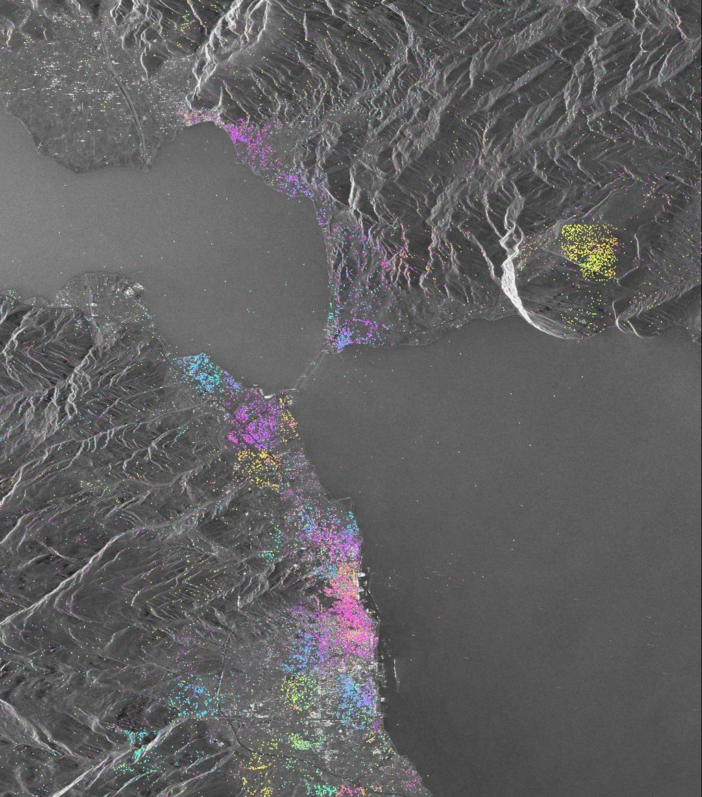
16 A PSI analysis: The case of the Rio-Antirio bridge (1 st phase) A major processing difficulty of the specific case study was the inability to unwrap the entire scene using a single reference point. The presence of water body between the Rio and Antirio areas (distance >2 km) meant no targets were available in order to propagate the unwrapping procedure from one side of the land to the other. Therefore, a decision was taken so that two separate IPTA processing were performed using different reference points in the vicinity of Rio and Antirio areas respectively. ESRIN, Terrafirma phase 5 th User Workshop 25-26/03/2009

17 PS interferometric result of the Rio area
 is observed. An undulation pattern is apparent specifically during the period 1995-1998.")
18 Typical displacement histories ( ) for specific point targets in Rio area. Displacement history of point 43329: A line of sight displacement of about 3cm (away from the sensor) is observed. Displacement history of point 45613: A line of sight displacement of about 1.5 cm (away from the sensor) is observed. An undulation pattern is apparent specifically during the period ESRIN, Terrafirma phase 3 User Workshop 25-26/03/2009

19 PS Interferometric result for the Antirio area
20 Typical displacement histories ( ) for specific point targets in Antirio area. Displacement history of point 36558: No displacement is observed. All values lie along zero value, meaning that this point remains stable during the whole considered period. Displacement history of point 36904: A line of sight displacement of about 1.5 cm (away from the sensor) is observed.

21 Point targets plotted over a Quickbird image in Google Earth environment with the related rate of deformation for each one in the Rio area and in a distance almost 200 m from seafront.

22 Point targets plotted over the geological map of Rio

23

24 Local GPS network covering spatially both sides


25 10 cm along the LOS 8/6/08 ML=6.5R Kato Achaia Interferometric pair / Bp=137 m Antirio 1.5 cm Rio 4 cm LOS Patra 5 cm epicentre


26 Start of 2 nd phase ENVISAT ASAR Average intensity image Task: deformation history charts for predefined prioritized point targets on the bridge

27 ASAR Interferometric Stacking Antirio Results consistent with ERS interferometric results Rio - 2 mm + 2 mm -4.2 mm - -3 mm/y +

28 IPTA Processing Candidate Points

29 2 nd Unrwapping st Unwrapping

30 The four pylons theoretically constitute excellent scatterers The deck is fully suspended and so it is difficult to detect scatterers on this. Potential scatterers of good quality on the bridge are found in an altitude range between 50 m and 120 m the bridge area in our DEM is defined as a zero altitude area redefine the sea-pixels as 1 cm of altitude A new processing is going on by creating a mask over the area where the bridge is located and giving an altitude value for the specific pixels of 50 m. On the two approach viaducts (for Rio and Antirio), a high number of scatterers of good quality are found.

31 Issaak please the final report! Issaak : Manager of the Bridge Project I need as much as more targets on the bridge!!!! (Mr. Papanikolas : Managing Director of the Bridge)
32 Thank you!
SAR APPLICATIONS IN GREECE With emphasis for Harokopio University/ Dep. of Geography activities
 SAR APPLICATIONS IN GREECE With emphasis for Harokopio University/ Dep. of Geography activities Issaak Parcharidis, Assist. Prof. Harokopio University of Athens Department of Geography parchar@hua.gr 4
Terrafirma Extension Tectonic Theme. 6 th Terrafirma Workshop ESA-ESRIN, December 1st, 2010
 Terrafirma Extension Tectonic Theme 6 th Terrafirma Workshop ESA-ESRIN, December 1st, 2010 Summary - Service Prospectus Presentation - The Terrafirma Extension Tectonic Theme (TFX-TT) - Greek Task Force
Advanced interpretation of land subsidence by validating multiinterferometric SAR data: the case study of Anthemountas basin (Northern Greece)
") Revision of paper Advanced interpretation of land subsidence by validating multiinterferometric SAR data: the case study of Anthemountas basin (Northern Greece) By Raspini et al. General comments This
Revision of paper Advanced interpretation of land subsidence by validating multiinterferometric SAR data: the case study of Anthemountas basin (Northern Greece) By Raspini et al. General comments This
The Santorini Inflation Episode, Monitored by InSAR and GPS
 The Santorini Inflation Episode, Monitored by InSAR and GPS Ioannis Papoutsis 1,2, Xanthos Papanikolaou 2, Michael Floyd 3, Kang Hyeun Ji 4, Charalampos Kontoes 1, Demitris Paradissis 2, Demitris Anastasiou
A COMPREHENSIVE ANALYSIS OF THE CAPABILITES AND LIMITATIONS OF PSI
 A COMPREHENSIVE ANALYSIS OF THE CAPABILITES AND LIMITATIONS OF PSI Rachel Holley, InSAR Surveying Consultant InSAR Surveying Team Fugro NPA Satellite Mapping Introduction Look at the capabilities and limitations
SAR interferometry Status and future directions. Rüdiger Gens
 SAR interferometry Status and future directions Rüdiger Gens Polarimetric InSAR Polarimetric InSAR InSAR - Status and future directions sensitivity to changes in surface scattering, even in the presence
TERRAFIRMA 6 th USER WORKSHOP. Use of displacement space measurements in geotechnical engineering: Application at Thessaly plain
 TERRAFIRMA 6 th USER WORKSHOP Greek group: Stamatopoulos and Associates Ltd. Harokopio University of Athens Use of displacement space measurements in geotechnical engineering: Application at Thessaly plain
THE FEASIBILITY AND APPLICATION OF PSI TO DETECT A RANGE OF GROUND AND STRUCTURE MOTION PHENOMENA.
 THE FEASIBILITY AND APPLICATION OF PSI TO DETECT A RANGE OF GROUND AND STRUCTURE MOTION PHENOMENA. Rachel Holley, InSAR Surveying Consultant InSAR Surveying Team Fugro NPA Satellite Mapping Introduction
VALIDATION OF THE PERMANENT SCATTERERS TECHNIQUE IN URBAN AREAS
 VALIDATION OF THE PERMANENT SCATTERERS TECHNIQUE IN URBAN AREAS Alessandro Ferretti, Claudio Prati, Fabio Rocca, Carlo Colesanti Dipartimento di Elettonica e Informazione Politecnico di Milano Piazza L.
SAR INTERFEROMETRIC ANALYSIS OF GROUND DEFORMATION AT SANTORINI VOLCANO (GREECE)
") SAR INTERFEROMETRIC ANALYSIS OF GROUND DEFORMATION AT SANTORINI VOLCANO (GREECE) Papageorgiou Elena (1), Foumelis Michael (2), Parcharidis Issaak (2) (1) National and Kapodistrian University of Athens,
SAR INTERFEROMETRIC ANALYSIS OF GROUND DEFORMATION AT SANTORINI VOLCANO (GREECE) Papageorgiou Elena (1), Foumelis Michael (2), Parcharidis Issaak (2) (1) National and Kapodistrian University of Athens,
PSI analysis of ground deformations along the south-western coast of the Gulf of Gdansk (Poland)
") FRINGE 2009 WORKSHOP, Advances in the Science and Applications of SAR Interferometry 30 November 4 December 2009 ESA-ESRIN Frascati, Italy PSI analysis of ground deformations along the south-western coast
FRINGE 2009 WORKSHOP, Advances in the Science and Applications of SAR Interferometry 30 November 4 December 2009 ESA-ESRIN Frascati, Italy PSI analysis of ground deformations along the south-western coast
Deformation measurement using SAR interferometry: quantitative aspects
 Deformation measurement using SAR interferometry: quantitative aspects Michele Crosetto (1), Erlinda Biescas (1), Ismael Fernández (1), Ivan Torrobella (1), Bruno Crippa (2) (1) (2) Institute of Geomatics,
GEO-VIII November Geohazard Supersites and Natural Laboratories Progress Report. Document 9
 GEO-VIII 16-17 November 2011 Geohazard Supersites and Natural Laboratories Progress Report Document 9 This document is submitted to GEO-VIII for information. Geohazard Supersites and Natural Laboratories
P079 First Results from Spaceborne Radar Interferometry for the Study of Ground Displacements in Urban Areas SUMMARY
 P079 First Results from Spaceborne Radar Interferometry for the Study of Ground Displacements in Urban Areas C.M. Crosetto (Instituto de Geomatica), C.A. Casas (University of Barcelona), R.G. Ranieri (University
RADAR Remote Sensing Application Examples
 RADAR Remote Sensing Application Examples! All-weather capability: Microwave penetrates clouds! Construction of short-interval time series through cloud cover - crop-growth cycle! Roughness - Land cover,
Abstract. 1. Introduction
 MONITORING AND INVESTIGATING CAUSES OF SHORT- AND LONG- TERM GROUND DEFORMATION BY IMPLEMENTING SAR INTERFEROMETRIC TECHNIQUES IN THE SETTLEMENT OF LARISSA, CENTRAL GREECE Abstract Falah Fakhri Department
Ground surface deformation of L Aquila. earthquake revealed by InSAR time series
 Ground surface deformation of L Aquila earthquake revealed by InSAR time series Reporter: Xiangang Meng Institution: First Crust Monitoring and Application Center, CEA Address: 7 Naihuo Road, Hedong District
ANALYSIS OF VERTICAL MOVEMENTS DETECTED BY RADAR INTERFEROMETRY IN URBAN AREAS
 10TH CZECH-POLISH WORKSHOP ON RECENT GEODYNAMICS OF THE SUDETEN AND ADJACENT AREAS Szklarska Poręba, Poland, November 5 7, 2009 ANALYSIS OF VERTICAL MOVEMENTS DETECTED BY RADAR INTERFEROMETRY IN URBAN
Detecting Illegal Mining Activities Using DInSAR
 Detecting Illegal Mining Activities Using DInSAR H.S. Kutoglu 1, H. Akcin 1, T. Deguchi 2, H. Kemaldere 1 1 Zonguldak Karaelmas Universitesi,, Türkiye; T 2 ERSDAC, Japan 17.06.2008 TS4D_3031 Study Area
GMES TERRAFIRMA. Validation of existing processing chains in Terrafirma stage 2 TECHNICAL NOTE ON THE TEST SITE SELECTION: ALKMAAR-AMSTERDAM
 GMES TERRAFIRMA ESRIN/Contract no. 19366/05/I-E Validation of existing processing chains in Terrafirma stage 2 TECHNICAL NOTE ON THE TEST SITE SELECTION: ALKMAAR-AMSTERDAM 2 nd April 2007 Final version
The financial and communal impact of a catastrophe instantiated by. volcanoes endlessly impact on lives and damage expensive infrastructure every
 Chapter 1 Introduction The financial and communal impact of a catastrophe instantiated by geophysical activity is significant. Landslides, subsidence, earthquakes and volcanoes endlessly impact on lives
ERS-ENVISAT CROSS-INTERFEROMETRY SIGNATURES OVER DESERTS. Urs Wegmüller, Maurizio Santoro and Christian Mätzler
 ERS-ENVISAT CROSS-INTERFEROMETRY SIGNATURES OVER DESERTS Urs Wegmüller, Maurizio Santoro and Christian Mätzler Gamma Remote Sensing AG, Worbstrasse 225, CH-3073 Gümligen, Switzerland, http://www.gamma-rs.ch,
Innovative Applications of Satellite Interferometry in the Oil&Gas Industry
 Innovative Applications of Satellite Interferometry in the Oil&Gas Industry A. Ferretti (1), G. Falorni (3), F. Novali (1), F. Rocca (2), A. Rucci (2), A. Tamburini (1) (1) Tele-Rilevamento Europa - TRE
Implementation of Multi-Temporal InSAR to monitor pumping induced land subsidence in Pingtung Plain, Taiwan
 Implementation of Multi-Temporal InSAR to monitor pumping induced land subsidence in Pingtung Plain, Taiwan Presenter: Oswald Advisor: Chuen-Fa Ni Date: March 09, 2017 Literature Review Pingtung Plain
Terrafirma monitoring and mapping landslide services for Europe based on InSAR satellite data
 Department of Earth Sciences CENTRE OF COMPETENCE OF THE CIVIL PROTECTION DEPARTMENT PRESIDENCY OF THE COUNCIL OF MINISTERS Terrafirma monitoring and mapping landslide services for Europe based on InSAR
Ground deformation in Thessaly, Central Greece, between 1992 and 2000 by means of ERS multi-temporal InSAR
 INGV Ground deformation in Thessaly, Central Greece, between 1992 and 2000 by means of ERS multi-temporal InSAR S. Atzori (1), C. Tolomei (1), S. Salvi (1), A. Ganas (2), S. Stramondo (1) and L. Colini
ERS-ENVISAT Cross-interferometry for Coastal DEM Construction
 ERS-ENVISAT Cross-interferometry for Coastal DEM Construction Sang-Hoon Hong and Joong-Sun Won Department of Earth System Sciences, Yonsei University, 134 Shinchon-dong, Seodaemun-gu, 120-749, Seoul, Korea
Pilot service: Southern Emilia Romagna (Italy)
") Pilot service: Southern Emilia Romagna (Italy) Surface deformation service provider (PSInSAR TM ) Geodetic and optical remote sensing data integration Final user The study area The Southern Emilia-Romagna
Pilot service: Southern Emilia Romagna (Italy) Surface deformation service provider (PSInSAR TM ) Geodetic and optical remote sensing data integration Final user The study area The Southern Emilia-Romagna
Terrafirma Persistent Scatterer Processing Validation
 Terrafirma Persistent Scatterer Processing Validation Nico Adam (1), Alessandro Parizzi (1), Michael Eineder (1), Michele Crosetto () (1) Remote Sensing Technology Institute () Institute of Geomatics Signal
CHINA-ITALY BILATERAL SYMPOSIUM ON THE COASTAL ZONE: EVOLUTION AND SAFEGUARD
 CHINA-ITALY BILATERAL SYMPOSIUM ON THE COASTAL ZONE: EVOLUTION AND SAFEGUARD 4-8 November 2007 Bologna, ITALY Editors F.Marabini, A.Galvani, M.Ciabatti Editorial Assistant M.Barazutti C.N.R. Bologna LAND
to: Interseismic strain accumulation and the earthquake potential on the southern San
 Supplementary material to: Interseismic strain accumulation and the earthquake potential on the southern San Andreas fault system by Yuri Fialko Methods The San Bernardino-Coachella Valley segment of the
The Potential of High Resolution Satellite Interferometry for Monitoring Enhanced Oil Recovery
 The Potential of High Resolution Satellite Interferometry for Monitoring Enhanced Oil Recovery Urs Wegmüller a Lutz Petrat b Karsten Zimmermann c Issa al Quseimi d 1 Introduction Over the last years land
EO Information Services. Assessing Vulnerability in the metropolitan area of Rio de Janeiro (Floods & Landslides) Project
 Project") EO Information Services in support of Assessing Vulnerability in the metropolitan area of Rio de Janeiro (Floods & Landslides) Project Ricardo Armas, Critical Software SA Haris Kontoes, ISARS NOA World
EO Information Services in support of Assessing Vulnerability in the metropolitan area of Rio de Janeiro (Floods & Landslides) Project Ricardo Armas, Critical Software SA Haris Kontoes, ISARS NOA World
Application of PSI technique to slope stability monitoring in the Daunia mountains, Italy
 ESA ESRIN - Frascati 28 November- 2 December Application of PSI technique to slope stability monitoring in the Daunia mountains, Italy F. Bovenga (1) (fabio.bovenga@ba.infn.it) L. Guerriero (1) R. Nutricato
Retrieving 3D deformation pattern of a landslide with hiresolution InSAR and in-situ measurements: Just landslide case-study
 Retrieving 3D deformation pattern of a landslide with hiresolution InSAR and in-situ measurements: Just landslide case-study Zbigniew Perski (1), Petar Marinković (2), Yngvar Larsen (3), Tomasz Wojciechowski
PERSISTENT SCATTERER INTERFEROMETRY: POTENTIAL AND LIMITS
 PERSISTENT SCATTERER INTERFEROMETRY: POTENTIAL AND LIMITS M. Crosetto a, O. Monserrat a, A. Jungner, B. Crippa b a Institute of Geomatics, Av. del Canal Olímpic, s/n, Castelldefels, E-08860, Spain (michele.crosetto,
Evaluation of subsidence from DinSAR techniques using Envisat-ASAR data at Toluca Valley Basin, Mexico.
 Evaluation of subsidence from DinSAR techniques using Envisat-ASAR data at Toluca Valley Basin, Mexico. Norma Angélica Dávila Hernández 1 Delfino Madrigal Uribe 1 Xanat Antonio Némiga 1 1 Autonomous University
DIFFERENTIAL INSAR STUDIES IN THE BOREAL FOREST ZONE IN FINLAND
 DIFFERENTIAL INSAR STUDIES IN THE BOREAL FOREST ZONE IN FINLAND Kirsi Karila (1,2), Mika Karjalainen (1), Juha Hyyppä (1) (1) Finnish Geodetic Institute, P.O. Box 15, FIN-02431 Masala, Finland, Email:
High-resolution temporal imaging of. Howard Zebker
 High-resolution temporal imaging of crustal deformation using InSAR Howard Zebker Stanford University InSAR Prehistory SEASAT Topographic Fringes SEASAT Deformation ERS Earthquake Image Accurate imaging
Figure B.15 - Example of plotting the landslide potential points
 Figure B.15 - Example of plotting the landslide potential points Figure B.16 - Example of landslide potential map based on topographic factor in north area of kabupaten Jember 37 from 61 Figure B.17 -
TERRAFIRMA USER GUIDE
 GMES TERRAFIRMA ESRIN/Contract no. 19366/05/I-EC TERRAFIRMA USER GUIDE A guide to the use and understanding of Persistent Scatterer Interferometry in the detection and monitoring of terrain-motion Authors:
Strategies for Measuring Large Scale Ground Surface Deformations: PSI Wide Area Product Approaches
 Strategies for Measuring Large Scale Ground Surface Deformations: PSI Wide Area Product Approaches J. Duro (1), R. Iglesias (1), P. Blanco-Sánchez (1), D. Albiol (1), T. Wright (2), N. Adam (3), F. Rodríguez
Geophysical Site Surveys
 Geophysical Site Surveys Simon Oakley Geoscience Team Leader Fugro Survey Limited 16/04/2014 Contents Menu Introduction Section 1 - Geophysical Site Surveys - Seabed Bathymetry - Shallow Geology - Seabed
Objectives and hypotheses. Remote sensing: applications for landslide hazard assessment and risk management. Ping Lu (University of Firenze) Methods
 Methods") Topical Workshop Remote sensing: applications for landslide hazard assessment and risk management Ping Lu (University of Firenze) Supervisors: Prof. Nicola Casagli; Prof. Filippo Catani (Unifi) Dr. Veronica
Topical Workshop Remote sensing: applications for landslide hazard assessment and risk management Ping Lu (University of Firenze) Supervisors: Prof. Nicola Casagli; Prof. Filippo Catani (Unifi) Dr. Veronica
2013 Esri Europe, Middle East and Africa User Conference October 23-25, 2013 Munich, Germany
 2013 Esri Europe, Middle East and Africa User Conference October 23-25, 2013 Munich, Germany Environmental and Disaster Management System in the Valles Altos Region in Carabobo / NW-Venezuela Prof.Dr.habil.Barbara
The March 11, 2011, Tohoku-oki earthquake (Japan): surface displacement and source modelling
: surface displacement and source modelling") The March 11, 2011, Tohoku-oki earthquake (Japan): surface displacement and source modelling Salvatore Stramondo Bignami C., Borgstrom S., Chini M., Guglielmino F., Melini D., Puglisi G., Siniscalchi V.,
The March 11, 2011, Tohoku-oki earthquake (Japan): surface displacement and source modelling Salvatore Stramondo Bignami C., Borgstrom S., Chini M., Guglielmino F., Melini D., Puglisi G., Siniscalchi V.,
Haiti Earthquake (12-Jan-2010) co-seismic motion using ALOS PALSAR
 co-seismic motion using ALOS PALSAR") Haiti Earthquake (12-Jan-2010) co-seismic motion using ALOS PALSAR Urs Wegmüller, Charles Werner, Maurizio Santoro Gamma Remote Sensing, CH-3073 Gümligen, Switzerland SAR data: JAXA, METI; PALSAR AO Project
Haiti Earthquake (12-Jan-2010) co-seismic motion using ALOS PALSAR Urs Wegmüller, Charles Werner, Maurizio Santoro Gamma Remote Sensing, CH-3073 Gümligen, Switzerland SAR data: JAXA, METI; PALSAR AO Project
ACHIEVING THE ERS-2 ENVISAT INTER-SATELLITE INTERFEROMETRY TANDEM CONSTELLATION.
 ACHIEVING THE ERS-2 ENVISAT INTER-SATELLITE INTERFEROMETRY TANDEM CONSTELLATION M. A. Martín Serrano (1), M. A. García Matatoros (2), M. E. Engdahl (3) (1) VCS-SciSys at ESA/ESOC, Robert-Bosch-Strasse
APPLICABILITY OF PSINSAR FOR BUILDING HAZARD IDENTIFICATION
 APPLICABILITY OF PSINSAR FOR BUILDING HAZARD IDENTIFICATION. STUDY OF THE 29 JANUARY 2006 KATOWICE EXHIBITION HALL COLLAPSE AND THE 24 FEBRUARY 2006 MOSCOW BASMANNY MARKET COLLAPSE Zbigniew Perski (1),
estimated by InSAR, and the temporal evolution of the deformation and possible cause.
 QUANTIFICATION OF SUBSIDENCE RATES ASSOCIATED WITH GROUNDWATER FLOW USING SAR INTERFEROMETRY J. Catalao (1), G. Nico (2), V. Conde (1), J.M. Miranda (1) (1) IDL, Universidade Lisboa, Campo Grande, Portugal,
EO, Land Motion and Climate Adaptation in Mediterranean Cities June 2014, Athens
 EO, Land Motion and Climate Adaptation in Mediterranean Cities 10-11 June 2014, Athens 1 Context UN Report: Water and Cities Facts and Figures 2 Context UN Report: Water and Cities Facts and Figures 3
InSAR measurements of volcanic deformation at Etna forward modelling of atmospheric errors for interferogram correction
 InSAR measurements of volcanic deformation at Etna forward modelling of atmospheric errors for interferogram correction Rachel Holley, Geoff Wadge, Min Zhu Environmental Systems Science Centre, University
PROVENCE INTER-COMPARISON. Marta Agudo, Michele Crosetto Institute of Geomatics
 PROVENCE INTER-COMPARISON Marta Agudo, Michele Crosetto Institute of Geomatics Final version Castelldefels, 16 March 2007 INDEX INDEX... 2 1. INTRODUCTION... 3 2. PRE-PROCESSING STEPS... 5 2.1 Input data...
Osservazione della terra da piattaforme remore ed in-situ fisse e mobili. Massimo Caccia CNR - ISSIA
 Osservazione della terra da piattaforme remore ed in-situ fisse e mobili Massimo Caccia CNR - ISSIA massimo.caccia@ge.issia.cnr.it 1 Research themes geo-physical monitoring environmental hazards monitoring
Dr. Simon Plank. German Remote Sensing Data Center (DFD), German Aerospace Center (DLR)
, German Aerospace Center (DLR)") Pre-survey suitability analysis of the differential and persistent scatterer synthetic ti aperture radar interferometry t method for deformation monitoring of landslides Dr. Simon Plank German Remote Sensing
Pre-survey suitability analysis of the differential and persistent scatterer synthetic ti aperture radar interferometry t method for deformation monitoring of landslides Dr. Simon Plank German Remote Sensing
DETECTION OF GROUND MOTION IN THE LISBON REGION WITH PERSISTENT SCATTERER INTERFEROMETRY (PSI)
") DETECTION OF GROUND MOTION IN THE LISBON REGION WITH PERSISTENT SCATTERER INTERFEROMETRY (PSI) Sandra HELENO 1, Afonso LOUREIRO 1,2, João FONSECA 1, João MATOS 1, João CARVALHO 3, Geraint COOKSLEY 4, Ana
DETECTION OF GROUND MOTION IN THE LISBON REGION WITH PERSISTENT SCATTERER INTERFEROMETRY (PSI) Sandra HELENO 1, Afonso LOUREIRO 1,2, João FONSECA 1, João MATOS 1, João CARVALHO 3, Geraint COOKSLEY 4, Ana
Application of a GIS for Earthquake Hazard Assessment and Risk Mitigation in Vietnam
 Application of a GIS for Earthquake Hazard Assessment and Risk Mitigation in Vietnam Nguyen Hong Phuong Earthquake Information and Tsunami Warning Centre, VAST OUTLINE Introduction Fault Source Model and
Real Time Subsidence Monitoring Techniques in Undercity Mining and a Case Study: Zonguldak Undercity Applications-Turkey
 Real Time Subsidence Monitoring Techniques in Undercity Mining and a Case Study: Zonguldak Undercity Hakan AKCIN, Hakan S. KUTOGLU, Turkey Keywords: Undercity mining, subsidence, PALSAR, RADARSAT, GNSS.
Remote Sensing and GIS Contribution to. Tsunami Risk Sites Detection. of Coastal Areas in the Mediterranean
 The Third International Conference on Early Warning (EWC III), 26.-29.March 2006 in Bonn Remote Sensing and GIS Contribution to Tsunami Risk Sites Detection of Coastal Areas in the Mediterranean BARBARA
Università di Roma La Sapienza, Facoltà d Ingegneria, Dipartimento di Idraulica,Trasporti e Strade (D.I.T.S.) 00185, Roma, Italy
 00185, Roma, Italy") DORIS FP7-EU PROJECT: EXPLOITATION OF 20 YEARS DINSAR DATA ARCHIVE FOR LANDSLIDE MONITORING Manunta M. (1), Calò F. (1), Paglia L., (1), Bonano M. (1,2), Lanari R. (1) (1) IREA-CNR, Via Diocleziano 328,
DORIS FP7-EU PROJECT: EXPLOITATION OF 20 YEARS DINSAR DATA ARCHIVE FOR LANDSLIDE MONITORING Manunta M. (1), Calò F. (1), Paglia L., (1), Bonano M. (1,2), Lanari R. (1) (1) IREA-CNR, Via Diocleziano 328,
Lab 9: Satellite Geodesy (35 points)
") Lab 9: Satellite Geodesy (35 points) Here you will work with GPS Time Series data to explore plate motion and deformation in California. This lab modifies an exercise found here: http://www.unavco.org:8080/cws/pbonucleus/draftresources/sanandreas/
Lab 9: Satellite Geodesy (35 points) Here you will work with GPS Time Series data to explore plate motion and deformation in California. This lab modifies an exercise found here: http://www.unavco.org:8080/cws/pbonucleus/draftresources/sanandreas/
ALOS PI Symposium 2009, 9-13 Nov 2009 Hawaii MOTION MONITORING FOR ETNA USING ALOS PALSAR TIME SERIES
 ALOS PI Symposium 2009, 9-13 Nov 2009 Hawaii ALOS Data Nodes: ALOS RA-094 and RA-175 (JAXA) MOTION MONITORING FOR ETNA USING ALOS PALSAR TIME SERIES Urs Wegmüller, Charles Werner and Maurizio Santoro Gamma
Implication of Secondary Geodynamic Phenomena on Co-seismic Interferometric Coherence
 Implication of Secondary Geodynamic Phenomena on Co-seismic Interferometric Coherence ABSTRACT Parcharidis Is. (1), Foumelis M. (2), Lekkas E. (3) & Segou M. (3) (1) Harokopio University of Athens, Dept.
Yev Kontar. Illinois State Geological Survey, University of Illinois at Urbana-Champaign
 Addressing Caribbean Geophysical Hazards through the Continuously Operating Caribbean GPS Observational Network (COCONet) and International Ocean Drilling Program (IODP) Yev Kontar Illinois State Geological
Application of advanced InSAR techniques for the measurement of vertical and horizontal ground motion in longwall minings
 University of Wollongong Research Online Coal Operators' Conference Faculty of Engineering and Information Sciences 2013 Application of advanced InSAR techniques for the measurement of vertical and horizontal
Surface Deformation Measurements Scientific Requirements & Challenges
 Surface Deformation Measurements Scientific Requirements & Challenges 1st Science and Application Workshop for Germany-Japan Next-Generation SAR M. Eineder, C. Minet, A. Parizzi Tokyo, 27.6.2013 Tandem-L
Urban land and infrastructure deformation monitoring by satellite radar interferometry
 Urban land and infrastructure deformation monitoring by satellite radar interferometry Lei Zhang and Xiaoli Ding Department of Land Surveying and Geo-Informatics (LSGI) The Hong Kong Polytechnic University
CHAPTER-7 INTERFEROMETRIC ANALYSIS OF SPACEBORNE ENVISAT-ASAR DATA FOR VEGETATION CLASSIFICATION
 147 CHAPTER-7 INTERFEROMETRIC ANALYSIS OF SPACEBORNE ENVISAT-ASAR DATA FOR VEGETATION CLASSIFICATION 7.1 INTRODUCTION: Interferometric synthetic aperture radar (InSAR) is a rapidly evolving SAR remote
A DInSAR Investigation of the Ground Settlement Time Evolution of Ocean-Reclaimed Lands in Shanghai
 A DInSAR Investigation of the Ground Settlement Time Evolution of Ocean-Reclaimed Lands in Shanghai Dr 3 project Id. 10644 Zhao, Qing 1 ; Pepe, Antonio 2 ; Gao, Wei 1 ; Li, Xiaofeng 3,4 ; Lu, Zhong 5 ;
KENTUCKY HAZARD MITIGATION PLAN RISK ASSESSMENT
 KENTUCKY HAZARD MITIGATION PLAN RISK ASSESSMENT Presentation Outline Development of the 2013 State Hazard Mitigation Plan Risk Assessment Determining risk assessment scale Census Data Aggregation Levels
Earthquakes and How to Measure Them
 Earthquakes and How to Measure Them Earth Systems Georgia Performance Standards: SES2c. Relate certain geologic hazards to plate tectonic settings. Created by: Christy Dion Paulding County High School
Section 19.1: Forces Within Earth Section 19.2: Seismic Waves and Earth s Interior Section 19.3: Measuring and Locating.
 CH Earthquakes Section 19.1: Forces Within Earth Section 19.2: Seismic Waves and Earth s Interior Section 19.3: Measuring and Locating Earthquakes Section 19.4: Earthquakes and Society Section 19.1 Forces
EO Information Services in support of Satellite Tools for Building Flood Defence Systems in Guyana
 EO Information Services in support of Satellite Tools for Building Flood Defence Systems in Guyana F. N. Koudogbo and A. Arnaud Altamira Information J. Leen, Eurosense World Bank HQ, Washington DC Date
DAMS REGIONAL SAFETY WARNING USING TIME-SERIES INSAR TECHNIQUES
 DAMS REGIONAL SAFETY WARNING USING TIME-SERIES INSAR TECHNIQUES Dora Roque *, Daniele Perissin, Ana P. Falcão, Ana M. Fonseca, Maria J. Henriques **, and Jacinto Franco * Laboratório Nacional de Engenharia
Earthquake hazards. Aims 1. To know how hazards are classified 2. To be able to explain how the hazards occur 3. To be able to rank order hazards
 Earthquake hazards Aims 1. To know how hazards are classified 2. To be able to explain how the hazards occur 3. To be able to rank order hazards Types of hazard Primary A direct result of the earthquake
Application of satellite InSAR data for hydrocarbon reservoir monitoring
 Application of satellite InSAR data for hydrocarbon reservoir monitoring A. Tamburini, A. Belson, A. Ferretti, F. Novali TRE Milano, Italy Copyright - Tele-Rilevamento Europa - 2004 Outline SqueeSAR TM
Candidate Name Centre Number Candidate Number CHANGING PHYSICAL AND HUMAN LANDSCAPES SAMPLE ASSESSMENT MATERIALS
 GCSE GEOGRAPHY Sample Assessment Materials 5 Candidate Name Centre Number Candidate Number 0 GCSE GEOGRAPHY UNIT 1 CHANGING PHYSICAL AND HUMAN LANDSCAPES SAMPLE ASSESSMENT MATERIALS 1 hour 30 minutes Section
INGV. Giuseppe Pezzo. Istituto Nazionale di Geofisica e Vulcanologia, CNT, Roma. Sessione 1.1: Terremoti e le loro faglie
 Giuseppe Pezzo Istituto Nazionale di Geofisica e Vulcanologia, CNT, Roma giuseppe.pezzo@ingv.it The study of surface deformation is one of the most important topics to improve the knowledge of the deep
Landslide Hazard Assessment Methodologies in Romania
 A Scientific Network for Earthquake, Landslide and Flood Hazard Prevention SciNet NatHazPrev Landslide Hazard Assessment Methodologies in Romania In the literature the terms of susceptibility and landslide
3.18 GEOLOGY AND SOILS
 3.18 GEOLOGY AND SOILS This section discusses geologic resource concerns as they relate to the environment, public safety, and project design both during construction and after completion of the project.
Integrated geological approach to the study of coastal subsidence in Emilia-Romagna. Luisa PERINI Calabrese Lorenzo, Luciani Paolo, Severi Paolo,
 Integrated geological approach to the study of coastal subsidence in Emilia-Romagna Luisa PERINI Calabrese Lorenzo, Luciani Paolo, Severi Paolo, Subsidence hazard of Emilia-Romagna coastal plain Caputo
The Safety project: Updating geohazard activity maps with Sentinel-1data
 The Safety project: Updating geohazard activity maps with Sentinel-1data Oriol Monserrat a, Safety Consortium a Centre Tecnològic de Telecomunicacions de Catalunya (CTTC/CERCA), Division of Geomatics,
PROANA A USEFUL SOFTWARE FOR TERRAIN ANALYSIS AND GEOENVIRONMENTAL APPLICATIONS STUDY CASE ON THE GEODYNAMIC EVOLUTION OF ARGOLIS PENINSULA, GREECE.
 PROANA A USEFUL SOFTWARE FOR TERRAIN ANALYSIS AND GEOENVIRONMENTAL APPLICATIONS STUDY CASE ON THE GEODYNAMIC EVOLUTION OF ARGOLIS PENINSULA, GREECE. Spyridoula Vassilopoulou * Institute of Cartography
LANDSLIDE IDENTIFICATION, MOVEMENT MONITORING AND RISK ASSESSMENT USING ADVANCED EARTH OBSERVATION TECHNIQUES
 LANDSLIDE IDENTIFICATION, MOVEMENT MONITORING AND RISK ASSESSMENT USING ADVANCED EARTH OBSERVATION TECHNIQUES European Leader Investigator Dr. Zbigniew Perski Carpathian Branch, Polish Geological Institute
Subsidence and associated shallow faulting hazard assessment in central Mexico using InSAR and GPS.
 Subsidence and associated shallow faulting hazard assessment in central Mexico using InSAR and GPS. E. Cabral-Cano, Instituto de Geofísica, UNAM D. Solano-Rojas, Univ. of Miami-RSMAS T. Oliver-Cabrera
Earthquake Hazards. Tsunami
 Earthquake Hazards Tsunami Review: What is an earthquake? Earthquake is the vibration (shaking) and/or displacement of the ground produced by the sudden release of energy. The point inside the Earth where
IZMIT BAY BRIDGE SOUTH APPROACH VIADUCT: SEISMIC DESIGN NEXT TO THE NORTH ANATOLIAN FAULT
 Istanbul Bridge Conference August 11-13, 2014 Istanbul, Turkey IZMIT BAY BRIDGE SOUTH APPROACH VIADUCT: SEISMIC DESIGN NEXT TO THE NORTH ANATOLIAN FAULT A. Giannakou 1, J. Chacko 2 and W. Chen 3 ABSTRACT
Earthquake Hazards. Tsunami
 Earthquake Hazards Tsunami Measuring Earthquakes Two measurements that describe the power or strength of an earthquake are: Intensity a measure of the degree of earthquake shaking at a given locale based
DETECTING ICE MOTION IN GROVE MOUNTAINS, EAST ANTARCTICA WITH ALOS/PALSAR AND ENVISAT/ASAR DATA
 DETECTING ICE MOTION IN GROVE MOUNTAINS, EAST ANTARCTICA WITH ALOS/PALSAR AND ENVISAT/ASAR DATA TIAN Xin (1), LIAO Mingsheng (1), ZHOU Chunxia (2), ZHOU Yu (3) (1) State Key Laboratory of Information Engineering
MAPPING DEFORMATION OF MAN-MADE LINEAR FEATURES USING DINSAR TECHNIQUE
 MAPPING DEFORMATION OF MAN-MADE LINEAR FEATURES USING DINSAR TECHNIQUE H. Wu a, *, Y. Zhang a, J. Zhang a, X. Chen b a Key Laboratory of Mapping from Space of State Bureau of Surveying and Mapping, Chinese
Earthquakes and How to Measure Them
 Earthquakes and How to Measure Them Earth Systems Georgia Performance Standards: SES2c. Relate certain geologic hazards to plate tectonic settings. Created by: Christy Dion Paulding County High School
The PaTrop Experiment
 Improved estimation of the tropospheric delay component in GNSS and InSAR measurements in the Western Corinth Gulf (Greece), by the use of a highresolution meteorological model: The PaTrop Experiment N.
Y. Shioi 1, Y. Hashizume 2 and H. Fukada 3
 Y. Shioi 1, Y. Hashizume 2 and H. Fukada 3 1 Emeritus Professor, Hachinohe Institute of Technology, Hachinohe, Japan 2 Chief Engineer, Izumo, Misawa, Aomori, Japan 3 Profesr, Geo-Technical Division, Fudo
3D temporal evolution of displacements recorded on Mt. Etna from the 2007 to 2010 through the SISTEM method
 3D temporal evolution of displacements recorded on Mt. Etna from the 2007 to 2010 through the SISTEM method Bonforte A., Guglielmino F.,, Puglisi G. INGV Istituto Nazionale di Gofisica e vulcanologia Osservatorio
COAL MINE LAND SUBSIDENCE MONITORING BY USING SPACEBORNE INSAR DATA-A CASE STUDY IN FENGFENG, HEBEI PROVINCE, CHINA
 COAL MINE LAND SUBSIDENCE MONITORING BY USING SPACEBORNE INSAR DATA-A CASE STUDY IN FENGFENG, HEBEI PROVINCE, CHINA Li Cao a, Yuehua Zhang a, Jianguo He a, Guang Liu b,huanyin Yue b, Runfeng Wang a, Linlin
Innovative Ways to Monitor Land Displacement
 ARTICLE Innovative Ways to Monitor Land Displacement When people think about landslides, they usually imagine large mud streams which cause considerable loss of life. Whereas such large-scale disasters
GMES Terrafirma II Stassfurt Case Study - Preliminary Results -
 GMES Terrafirma II Stassfurt Case Study - Preliminary Results - Friedrich Kuehn BGR/Germany Email: friedrich.kuehn@bgr.de PSI-Processing by DLR Oberpfaffenhofen/Germany The Study Area: - The Stassfurt/Bernburg
Applying Hazard Maps to Urban Planning
 Applying Hazard Maps to Urban Planning September 10th, 2014 SAKAI Yuko Disaster Management Expert JICA Study Team for the Metro Cebu Roadmap Study on the Sustainable Urban Development 1 Contents 1. Outline
Radar Remote Sensing: Monitoring Ground Deformations and Geohazards from Space
 Radar Remote Sensing: Monitoring Ground Deformations and Geohazards from Space Xiaoli Ding Department of Land Surveying and Geo-Informatics The Hong Kong Polytechnic University A Question 100 km 100 km
ESTIMATION OF LANDFORM CLASSIFICATION BASED ON LAND USE AND ITS CHANGE - Use of Object-based Classification and Altitude Data -
 ESTIMATION OF LANDFORM CLASSIFICATION BASED ON LAND USE AND ITS CHANGE - Use of Object-based Classification and Altitude Data - Shoichi NAKAI 1 and Jaegyu BAE 2 1 Professor, Chiba University, Chiba, Japan.