THE FEASIBILITY AND APPLICATION OF PSI TO DETECT A RANGE OF GROUND AND STRUCTURE MOTION PHENOMENA.
|
|
|
- Cynthia Morton
- 5 years ago
- Views:
Transcription


1 THE FEASIBILITY AND APPLICATION OF PSI TO DETECT A RANGE OF GROUND AND STRUCTURE MOTION PHENOMENA. Rachel Holley, InSAR Surveying Consultant InSAR Surveying Team Fugro NPA Satellite Mapping
2 Introduction Presentation will discuss: What is a feasibility assessment? What factors do we need to consider to decide if InSAR is suitable? Look at 3 Terrafirma Case Studies: Vilnius in Lithuania, Liege in Belgium, Esbjerg in Denmark
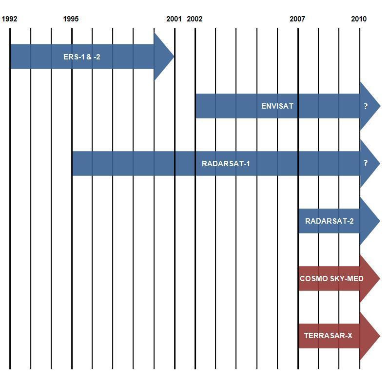
3 PSI Persistent Scatterer InSAR (PSI): Utilises more than 30 SAR images acquired as far back as 1992 Detection of Persistent Scatterers e.g. buildings, bridges and other structures Height of PS calculated at each image benchmark Historical motion revealed and time series of motion produced
4 PSI Capabilities: Unique ground motion information service Remotely map historical ground and structure motion (archive images from 1992) Monitor ground and structure motion (programme SAR images) Millimetric precision (as shown during the Terrafirma validation) Wide-area results (up to 100km x 100km) Dense PS networks (over 400 PS/km 2 in urban areas) PS motion history (individual time series) Global Coverage Virtual GPS network (higher density and better in vertical domain) Complementary information source Constraints/Limitations: Location specific (best suited to urban and semi-urban areas) Data quantity (at least 15 SAR images, more data = more precise) Temporal distribution of data (even, frequent distribution of SAR imagery) Motion magnitude (motions ranging from mm to 10cm/year) PS point locations (location serendipitous) Non-linear motion (significantly non-linear ground motion may not be captured)


5 Market Sectors and Applications Opportunities for input into the following markets: Civil Engineering Environment & Geohazards Oil, Gas & Mining Utilities & Telecommunication Legal Media Diverse range of applications: Urban stability, tunnel settlement Flood risk and mitigation (dams, levees, dykes, embankments etc.) Volcanic and seismic events, landslides Oil / gas reservoir stability, Mine subsidence and gas storage Asset management
6 Feasibility assessments Feasibility assessments: Establish which InSAR technique is most applicable Establish if it meets its users needs Key questions for PSI feasibility Motion Direction Topography Groundcover Climate Motion Magnitude Motion Spatial Extent Data Availability
7 Motion Direction
8 Topography SAR image distortion Layover Foreshortening Shadow DEM s are used to assess the topography and decide which pass is most suitable (if any).


9 Ground cover and Land use InSAR only works under coherent conditions Different InSAR techniques may be better suited to different applications PSI certain PS density required for technique to work
10 Climate Water vapour distribution in the atmosphere can interfere with the phase signal try to remove this in PSI, but can t always as it is dependant on the number of images and the PS density Certain types of snow and ice cover can interfere the phase signal remove these SAR images Flooding, snow melt, surface water can cause coherence to be lost
11 Motion Magnitude Need to consider the revisit time of the satellite and the radar wavelength Magnitude of motion need to be consider will PSI pick it up? PSI motion > 10 cm per year cannot be measured (C-band) PSI can detect motion rates in the order of millimetres per year SAR frequency band (satellites) Minimum revisit time (days) Motion measured in one fringe cycle (mm) DifSAR (mm) Typical minimum detectable movement PSI (mm/year) Artificial Reflector InSAR (mm) DifSAR (mm) Typical maximum detectable movement PSI (mm/year) Artificial Reflector InSAR (mm) X-Band (Terrasar-X) C-Band (Envisat and ERS) < 1 < C-Band (Radarsat-1 and Radarsat-2) L-Band (ALOS) N/A N/A 100+ N/A N/A


12 Motion Spatial Extent The satellite s spatial resolution needs to be considered as motion extent may be too small to be detected. DEAD SEA SINK HOLES HOLBECK
13 Data Availability


14 Typical PS Buildings Bridges Sourced from Royal Belgium Institute of Natural Sciences Sourced from LEGMA Pylons Dams and Dykes Rocky outcrops


15 Factors that affect the presence of a PS (1) Orientation of the target If not in LOS of satellite, the PS feature will not be picked up Reflectivity of the target If not bright compared to surroundings then will not be selected as a PS This can be a combination of orientation of the target and ground cover


16 Factors that affect the presence of a PS (2) Temporal persistence of the target If want to look at something that has only been present since 1997, then PSI processing 1992 to 2000 will not include it as a persistent scatterer

17 Case Study 1: Vilnius, Lithuania (1) Why was the site chosen? USER: Capital city of Lithuania (population of 0.6 million) Built on highly compressible quaternary sediments. Susceptible to differential subsidence due to construction, water abstraction and drought Whole country dependent on ground water => water use is increasing 20% of piped water is leaking => localised subsidence Possible neo-tectonic movement due to glacial rebound Landslides are common along 2 principal rivers which meet in the centre of the city
18 Case Study 1: Vilnius, Lithuania (2) Feasibility assessment


19 Case Study 1: Vilnius, Lithuania (3) Topography
 Max motion 56.2 mm/year, minimum motion -68.")
20 Case Study 1: Vilnius, Lithuania (4) Study period: 08 May 1992 to 13 August 2001 Data used: ERS-1 & ERS-2 PS Density: ~ 9 PS/km 2 Average annual motion rate of the entire processed area = mm/year (std dev 0.484) Max motion 56.2 mm/year, minimum motion mm/year 78 % of PS points were classed as stable, 16% of points subsiding and 6 % of points uplifting Problems: small data stack (32 images), highly variable weather conditions, lack of prerequisite knowledge of ground motions
 What did the result reveal? 1.")


21 Case Study 1: Vilnius, Lithuania (5) What did the result reveal? 1. Ground water extraction / recharge Example: The Territory of Furniture Centre Audėjas PS concentrated in this region indicate negative motion. Buildings were constructed during year period. The ground water level was m below the surface pre-construction. Post construction and the installation of drainage system dropped to 6-7 m. 2. Landslide and Erosion Example: Grigiškės area (alluvial deposits of the Neris and Voke Rivers. PS concentrated in this region showed negative motion. Settlement of houses has occurred in this region. The motion may be related to changes of the groundwater regime. 3. Compressible soils
22 Case Study 1: Vilnius, Lithuania (6) User analysis The examples of movements detected by PSI examined on site included subsidence linked to the presence of compressible deposits (organic, lacustrine etc.), mass movements, suffusion, changes of groundwater, and location of large engineering constructions. Lithuanian Geological Survey No evidence of relationship between PS result and tectonic activity which is thought to occur in the area No new information as such but some areas that require further investigation Applications identified by user: Dams Power Infrastructure Monitoring transportation networks obtaining ground and structure motion information across urban areas
23 Case Study 2: Liege, Belgium (1) Why was the site chosen? USER: City is a former mining site Mine collapse and flooding due to a rising water table. Uplift and subsidence is common Running through the former mining area is an underground high speed train tunnel Southern Liege is a karst area with sink holes and surface collapse. Building damage has led to changes to the law.
 Feasibility")
24 Case Study 2: Liege, Belgium (2) Feasibility assessment
")
25 Case Study 2: Liege, Belgium (3) Topography
 Max motion 21.61 mm/year, minimum motion -3.01mm/year 76 % of PS points were classed as stable, 18 % of points subsiding and 6 % of points uplifting")
26 Case Study 2: Liege, Belgium (4) Study period: 23 April September 2005 Data used: ERS-1 / ERS-2 / ASAR PS Density: ~48 PS /km 2 Average annual motion rate of the entire processed area = mm/year (std dev 2.580) Max motion mm/year, minimum motion -3.01mm/year 76 % of PS points were classed as stable, 18 % of points subsiding and 6 % of points uplifting
 and groundwater")

27 Case Study 2: Liege, Belgium (5) What did the result reveal? 1. Mining Example: Ground movements related to the presence of abandoned mined exploitations (subsidence) and groundwater recharge leading to an increase of the hydrostatic pressure into the mine aquifer (uplift). 2. Ground water extraction / recharge Example: Former coal mining areas are now experiencing rebound after cessation of mining and ground water abstraction as aquifer recharges 3. Compressible soils 4. Reclaimed land
28 Case Study 2: Liege, Belgium (6) User analysis Both GPS and levelling indicate motion on a similar scale to the PS data with the absolute difference lower than 1mm. 2 main movements identified: negative motion around river Meuse (alluvial plains), positive motion in the city centre and in the hills Good correspondence with karst sites Applications identified by user: better determine spatially the ground motion related to mining groundwater provide information for housing management authorities Underground construction Post mine hydrological surveys
 Feasibility")
29 Case Study 3: Esbjerg, Denmark (2) Feasibility assessment
30 Case Study 3: Esbjerg, Denmark (1) Why was the site chosen? USER: City vulnerable to flooding from the north sea storm surges harbour often experiences flooding which causes economic loss Isostatic rebound has caused vertical land movement and sea level rises have caused an increased flood risk Higher frequency of storm surges => greater risk of flooding Study potential impact of flooding on ground motion and identify zones where dykes may be at risk South of Esbjerg the land is very low and is protected by dykes


31 Case Study 3: Esbjerg, Denmark (3) Topography
 Max motion 39.1 mm/year, minimum motion -29.")
32 Case Study 3: Esbjerg, Denmark (4) Study period: 13 June December 2000 Data used: ERS-1 & ERS-2 PS Density: ~19 PS /km 2 Average annual motion rate of the entire processed area = mm/year (std dev 1.954) Max motion 39.1 mm/year, minimum motion mm/year 87 % of PS points were classed as stable, 4 % of points subsiding and 9 % of points uplifting
 Example: Harbour: The Esbjerg Harbour is to a large degree built on landfill.")

33 Case Study 3: Esbjerg, Denmark (5) What did the result reveal? 1. Compressible sediments 2. Ground abstraction 3. Landfill (suspected) Example: Harbour: The Esbjerg Harbour is to a large degree built on landfill. This is reflected by some cases of very high vertical movement. 4. Construction induced subsidence 5. Sediment consolidation Example: Railroad: In the area west of Esbjerg, along the railroad towards Tjæreborg and Bramming. numerous cases are found where the railroad tracks appear to induce a settling of known unconsolidated postglacial freshwater and marine deposits.
34 Case Study 3: Esbjerg, Denmark (6) User analysis Some known and newly discovered defornation (railway line settlement) identified Applications identified by user: PSI provides synoptic view from regional to local scale Easier to understand processes occurring than traditional levelling where observations are primarily taken along a linear profile.
35 Conclusion PSI can be used monitor a variety of applications but it is crucial a feasibility assessment is carried out to ascertain the suitability of the technique Doing a feasibility assessment allows us to: Optimise data stack to get the maximum number of PS Look at the weather to remove any potentially problematic images Be aware that if it is a small data-stack, then there will be a low PS density which may affect processing Mechanism Vilnius Liege Esbjerg Creep Compressible soils Reclaimed Land site Dissolution Groundwater recharge Groundwater abstraction Mining Erosion Landslide Waste Disposal / Landfill
A COMPREHENSIVE ANALYSIS OF THE CAPABILITES AND LIMITATIONS OF PSI
 A COMPREHENSIVE ANALYSIS OF THE CAPABILITES AND LIMITATIONS OF PSI Rachel Holley, InSAR Surveying Consultant InSAR Surveying Team Fugro NPA Satellite Mapping Introduction Look at the capabilities and limitations
EO, Land Motion and Climate Adaptation in Mediterranean Cities June 2014, Athens
 EO, Land Motion and Climate Adaptation in Mediterranean Cities 10-11 June 2014, Athens 1 Context UN Report: Water and Cities Facts and Figures 2 Context UN Report: Water and Cities Facts and Figures 3
DIFFERENTIAL INSAR STUDIES IN THE BOREAL FOREST ZONE IN FINLAND
 DIFFERENTIAL INSAR STUDIES IN THE BOREAL FOREST ZONE IN FINLAND Kirsi Karila (1,2), Mika Karjalainen (1), Juha Hyyppä (1) (1) Finnish Geodetic Institute, P.O. Box 15, FIN-02431 Masala, Finland, Email:
Pilot service: Southern Emilia Romagna (Italy)
") Pilot service: Southern Emilia Romagna (Italy) Surface deformation service provider (PSInSAR TM ) Geodetic and optical remote sensing data integration Final user The study area The Southern Emilia-Romagna
Pilot service: Southern Emilia Romagna (Italy) Surface deformation service provider (PSInSAR TM ) Geodetic and optical remote sensing data integration Final user The study area The Southern Emilia-Romagna
EO Information Services in support of Satellite Tools for Building Flood Defence Systems in Guyana
 EO Information Services in support of Satellite Tools for Building Flood Defence Systems in Guyana F. N. Koudogbo and A. Arnaud Altamira Information J. Leen, Eurosense World Bank HQ, Washington DC Date
b Blackwell Science Environmental Geology PRINCIPLES AND PRACTICE
 Environmental Geology PRINCIPLES AND PRACTICE Fred G. Bell Department of Geology and Applied Geology University of Natal, Durban, South Africa b Blackwell Science Preface, ix 1 Introduction, 1 1.1 Planning
ANALYSIS OF VERTICAL MOVEMENTS DETECTED BY RADAR INTERFEROMETRY IN URBAN AREAS
 10TH CZECH-POLISH WORKSHOP ON RECENT GEODYNAMICS OF THE SUDETEN AND ADJACENT AREAS Szklarska Poręba, Poland, November 5 7, 2009 ANALYSIS OF VERTICAL MOVEMENTS DETECTED BY RADAR INTERFEROMETRY IN URBAN
Copernicus Overview. Major Emergency Management Conference Athlone 2017
 Copernicus Overview Major Emergency Management Conference Athlone 2017 Copernicus is a European programme implemented by the European Commission. The services address six thematic areas: land, marine,
GMES Terrafirma II Stassfurt Case Study - Preliminary Results -
 GMES Terrafirma II Stassfurt Case Study - Preliminary Results - Friedrich Kuehn BGR/Germany Email: friedrich.kuehn@bgr.de PSI-Processing by DLR Oberpfaffenhofen/Germany The Study Area: - The Stassfurt/Bernburg
Prepared By: John Blair Sean Donahue Celeste Hoffman Kimberly Klinkers Megan Slater
 Prepared By: John Blair Sean Donahue Celeste Hoffman Kimberly Klinkers Megan Slater Green River Basin Location Green River Basin Stratigraphic Correlation Chart showing Study Map Units Sample of Existing
Integrated Space Applications in Transport, Energy & Safety Oil & Gas Exploration
 Exploration & Production Technology delivering breakthrough solutions Integrated Space Applications in Transport, Energy & Safety Oil & Gas Exploration Dr Colin Grant Engineering Technical Authority, Metocean
Continuous Risk Assessment of Structures and Plants in Areas of Ground Deformation Susceptibility by Space-based SAR/ASAR Interferometry
 CCN4 Project Continuous Risk Assessment of Structures and Plants in Areas of Ground Deformation Susceptibility by Space-based SAR/ASAR Interferometry Issaak Parcharidis*, Michael Foumelis and Penelope
The known requirements for Arctic climate services
 The known requirements for Arctic climate services based on findings described in STT White paper 8/2015 Johanna Ekman / EC PHORS STT Regional drivers The Arctic region is home to almost four million people
Infrastructure monitoring using SAR interferometry
 Infrastructure monitoring using SAR interferometry Hossein Nahavandchi Roghayeh Shamshiri Norwegian University of Science and Technology (NTNU), Department of Civil and Environmental Engineering Geodesy
Programmatic Approaches to Assessing and Mitigating Risk to Pipelines from Natural Forces
 Programmatic Approaches to Assessing and Mitigating Risk to Pipelines from Natural Forces 23 rd International Petroleum Environmental Conference New Orleans, Louisiana November 8-10, 2016 Introduction
Implementation of Multi-Temporal InSAR to monitor pumping induced land subsidence in Pingtung Plain, Taiwan
 Implementation of Multi-Temporal InSAR to monitor pumping induced land subsidence in Pingtung Plain, Taiwan Presenter: Oswald Advisor: Chuen-Fa Ni Date: March 09, 2017 Literature Review Pingtung Plain
WATER ON AND UNDER GROUND. Objectives. The Hydrologic Cycle
 WATER ON AND UNDER GROUND Objectives Define and describe the hydrologic cycle. Identify the basic characteristics of streams. Define drainage basin. Describe how floods occur and what factors may make
Physical Geography: Patterns, Processes, and Interactions, Grade 11, University/College Expectations
 Geographic Foundations: Space and Systems SSV.01 explain major theories of the origin and internal structure of the earth; Page 1 SSV.02 demonstrate an understanding of the principal features of the earth
APPLICABILITY OF PSINSAR FOR BUILDING HAZARD IDENTIFICATION
 APPLICABILITY OF PSINSAR FOR BUILDING HAZARD IDENTIFICATION. STUDY OF THE 29 JANUARY 2006 KATOWICE EXHIBITION HALL COLLAPSE AND THE 24 FEBRUARY 2006 MOSCOW BASMANNY MARKET COLLAPSE Zbigniew Perski (1),
Innovative Applications of Satellite Interferometry in the Oil&Gas Industry
 Innovative Applications of Satellite Interferometry in the Oil&Gas Industry A. Ferretti (1), G. Falorni (3), F. Novali (1), F. Rocca (2), A. Rucci (2), A. Tamburini (1) (1) Tele-Rilevamento Europa - TRE
Coastal Vulnerability Assessment in Semarang City, Indonesia Based on Sea Level Rise and Land Subsidence Scenarios
 Coastal Vulnerability Assessment in Semarang City, Indonesia Based on Sea Level Rise and Land Subsidence Scenarios I. M. Radjawane, D. Hartadi and W. R. Lusano Oceanography Research Division Fac. of Earth
Flash flood disaster in Bayangol district, Ulaanbaatar
 Flash flood disaster in Bayangol district, Ulaanbaatar Advanced Training Workshop on Reservoir Sedimentation Management 10-16 October 2007. IRTCES, Beijing China Janchivdorj.L, Institute of Geoecology,MAS
Surface Processes Focus on Mass Wasting (Chapter 10)
") Surface Processes Focus on Mass Wasting (Chapter 10) 1. What is the distinction between weathering, mass wasting, and erosion? 2. What is the controlling force in mass wasting? What force provides resistance?
Surface Processes Focus on Mass Wasting (Chapter 10) 1. What is the distinction between weathering, mass wasting, and erosion? 2. What is the controlling force in mass wasting? What force provides resistance?
Retrieving 3D deformation pattern of a landslide with hiresolution InSAR and in-situ measurements: Just landslide case-study
 Retrieving 3D deformation pattern of a landslide with hiresolution InSAR and in-situ measurements: Just landslide case-study Zbigniew Perski (1), Petar Marinković (2), Yngvar Larsen (3), Tomasz Wojciechowski
Dr. Simon Plank. German Remote Sensing Data Center (DFD), German Aerospace Center (DLR)
, German Aerospace Center (DLR)") Pre-survey suitability analysis of the differential and persistent scatterer synthetic ti aperture radar interferometry t method for deformation monitoring of landslides Dr. Simon Plank German Remote Sensing
Pre-survey suitability analysis of the differential and persistent scatterer synthetic ti aperture radar interferometry t method for deformation monitoring of landslides Dr. Simon Plank German Remote Sensing
Blanca Payàs 1, Ryan Morris 2, Alain Arnaud 1, David Albiol 1, John Bradshaw 3, Javier Duro 1. Abstract
 Surface monitoring using radar satellite images to measure ground deformation: applied to Coal Seam Gas production areas to comply with regulatory requirements Blanca Payàs 1, Ryan Morris 2, Alain Arnaud
Use of remote sensing for proactive management of geotechnical assets on the strategic road network in England
 Use of remote sensing for proactive management of geotechnical assets on the strategic road network in England Áine Ní Bhreasail Ground Related Risk to Transportation Infrastructure October 26 th -27 th
GEO-VIII November Geohazard Supersites and Natural Laboratories Progress Report. Document 9
 GEO-VIII 16-17 November 2011 Geohazard Supersites and Natural Laboratories Progress Report Document 9 This document is submitted to GEO-VIII for information. Geohazard Supersites and Natural Laboratories
InSAR measurements of volcanic deformation at Etna forward modelling of atmospheric errors for interferogram correction
 InSAR measurements of volcanic deformation at Etna forward modelling of atmospheric errors for interferogram correction Rachel Holley, Geoff Wadge, Min Zhu Environmental Systems Science Centre, University
9/13/2011 CHAPTER 9 AND SUBSIDENCE. Case History: La Conchita Landslide. Introduction
 CHAPTER 9 SLOPE PROCESSES, LANDSLIDES, AND SUBSIDENCE Case History: La Conchita Landslide La Conchita: small coastal community 80 km (50 mi) northwest of Los Angeles Landslide occurred on January 10, 2005
PERSISTENT SCATTERER INTERFEROMETRY: POTENTIAL AND LIMITS
 PERSISTENT SCATTERER INTERFEROMETRY: POTENTIAL AND LIMITS M. Crosetto a, O. Monserrat a, A. Jungner, B. Crippa b a Institute of Geomatics, Av. del Canal Olímpic, s/n, Castelldefels, E-08860, Spain (michele.crosetto,
GMES Terrafirma II Stassfurt Case Study - Preliminary Results -
 GMES Terrafirma II Stassfurt Case Study - Preliminary Results - Presenter: Kai Hahne Author: Friedrich Kuehn BGR/Germany Email: kai.hahne@bgr.de friedrich.kuehn@bgr.de PSI-Processing by DLR Oberpfaffenhofen/Germany
Land subsidence due to groundwater withdrawal in Hanoi, Vietnam
 Land Subsidence (Proceedings of the Fifth International Symposium on Land Subsidence, The Hague, October 1995). 1AHS Publ. no. 234, 1995. 55 Land subsidence due to groundwater withdrawal in Hanoi, Vietnam
LANDSLIDE IDENTIFICATION, MOVEMENT MONITORING AND RISK ASSESSMENT USING ADVANCED EARTH OBSERVATION TECHNIQUES
 LANDSLIDE IDENTIFICATION, MOVEMENT MONITORING AND RISK ASSESSMENT USING ADVANCED EARTH OBSERVATION TECHNIQUES European Leader Investigator Dr. Zbigniew Perski Carpathian Branch, Polish Geological Institute
SLOPE PROCESSES, LANDSLIDES, AND SUBSIDENCE
 CHAPTER 9 SLOPE PROCESSES, LANDSLIDES, AND SUBSIDENCE La Conchita slide January 10, 2005 Triggered by heavy rainfall, reactivation along an older landslide surface (35,000 years ago, 6000 years ago, and
Land Administration and Cadastre
 Geomatics play a major role in hydropower, land and water resources and other infrastructure projects. Lahmeyer International s (LI) worldwide projects require a wide range of approaches to the integration
Subsidence Monitoring in Hampton Roads Using Satellites
 ODU Digital Commons July 29, 2016: The Latest in Sea Level Rise Science Hampton Roads Sea Level Rise/Flooding Adaptation Forum 7-29-2016 Subsidence Monitoring in Hampton Roads Using Satellites Ben Hamlington
European Space Agency
 Guidelines - Guidelines how/when to interact during the WebEx session: - Due to the number of attendees, please keep always your webcam and microphone switched-off - You can use anytime the chat to all
VALIDATION OF THE PERMANENT SCATTERERS TECHNIQUE IN URBAN AREAS
 VALIDATION OF THE PERMANENT SCATTERERS TECHNIQUE IN URBAN AREAS Alessandro Ferretti, Claudio Prati, Fabio Rocca, Carlo Colesanti Dipartimento di Elettonica e Informazione Politecnico di Milano Piazza L.
Natural Hazards Large and Small
 Specialty Seminar on Engineering of Geo-Hazards ASCE Met Section Geotechnical Group and Geo-Institute of ASCE 16 May 2007 Natural Hazards Large and Small Evaluation and Mitigation Edward Kavazanjian, Jr.,
MAPPING DEFORMATION OF MAN-MADE LINEAR FEATURES USING DINSAR TECHNIQUE
 MAPPING DEFORMATION OF MAN-MADE LINEAR FEATURES USING DINSAR TECHNIQUE H. Wu a, *, Y. Zhang a, J. Zhang a, X. Chen b a Key Laboratory of Mapping from Space of State Bureau of Surveying and Mapping, Chinese
Section 11.1 pp Where Mountains Form
 Section 11.1 pp. 236 237 Where Mountains Form Chapter 11 Set a Purpose: TE, p. 236 Reading Study Guide, p. 36 Discussion: TE, p. 236 Differentiating ion Reading Support: TE, p. 236 Visual Teaching Interpret
Lecture 15: Subsidence
 Lecture 15: Subsidence Key Questions 1. How does removal of groundwater cause subsidence on a regional scale? 2. Under what conditions does a building sink into sediment? 3. Why do clays consolidate more
InSAR atmospheric effects over volcanoes - atmospheric modelling and persistent scatterer techniques
 InSAR atmospheric effects over volcanoes - atmospheric modelling and persistent scatterer techniques Rachel Holley 1,2, Geoff Wadge 1, Min Zhu 1, Ian James 3, Peter Clark 4 Changgui Wang 4 1. Environmental
Remote sensing and GIS for multi-hazard risk assessments in the coastal zone: recent applications and challenges in the Pacific Jens Kruger
 Remote sensing and GIS for multi-hazard risk assessments in the coastal zone: recent applications and challenges in the Pacific Jens Kruger Geoscience Division Pacific Community (SPC) The First Pacific
P079 First Results from Spaceborne Radar Interferometry for the Study of Ground Displacements in Urban Areas SUMMARY
 P079 First Results from Spaceborne Radar Interferometry for the Study of Ground Displacements in Urban Areas C.M. Crosetto (Instituto de Geomatica), C.A. Casas (University of Barcelona), R.G. Ranieri (University
ENVIRONMENTAL GEOSCIENCE UNIFORM SYLLABUS
 ENVIRONMENTAL GEOSCIENCE UNIFORM SYLLABUS The Association of Professional Engineers and Geoscientists of the Province of British Columbia Note: 1. This Syllabus May Be Subject To Change 2. These Courses
Your web browser (Safari 7) is out of date. For more security, comfort and the best experience on this site: Update your browser Ignore
 is out of date. For more security, comfort and the best experience on this site: Update your browser Ignore") Your web browser (Safari 7) is out of date. For more security, comfort and the best experience on this site: Update your browser Ignore BEDRO CK For the complete encyclopedic entry with media resources,
Your web browser (Safari 7) is out of date. For more security, comfort and the best experience on this site: Update your browser Ignore BEDRO CK For the complete encyclopedic entry with media resources,
J M MIRANDA UNIVERSITY OF LISBON THE USE OF REMOTE SENSING FOR EARTHQUAKE RISK ASSESSMENT AND MITIGATION
 1 THE USE OF REMOTE SENSING FOR EARTHQUAKE RISK ASSESSMENT AND MITIGATION 2 the observation of strong ground motion and aftershock sequences as well as the investigation of the destruction from these earthquakes
Application of advanced InSAR techniques for the measurement of vertical and horizontal ground motion in longwall minings
 University of Wollongong Research Online Coal Operators' Conference Faculty of Engineering and Information Sciences 2013 Application of advanced InSAR techniques for the measurement of vertical and horizontal
FIG Working Week May, Bulgaria From the wisdom of the ages to the challanges of modern world
 FIG Working Week 17-21 May, Bulgaria From the wisdom of the ages to the challanges of modern world COASTAL RISK ANALYSIS OF THE BLACK SEA UNDER THE SEA LEVEL RISE N e v i n B e t u l A V S A R, S e n o
Satellite-Based Radar Terrain Surface Deformation Mapping
 Essential Information Solutions For Decision Making Satellite-Based Radar Terrain Surface Deformation Mapping APSG US West Summer Meeting, Denver CO June 26, 2014 1 Lines of Business GEOSPATIAL SOLUTIONS:
TERRAFIRMA USER GUIDE
 GMES TERRAFIRMA ESRIN/Contract no. 19366/05/I-EC TERRAFIRMA USER GUIDE A guide to the use and understanding of Persistent Scatterer Interferometry in the detection and monitoring of terrain-motion Authors:
SECTION II Hydrological risk
 Chapter 3 Understanding disaster risk: hazard related risk issues SECTION II Hydrological risk Peter Salamon Coordinating lead author Hannah Cloke Lead author 3.4 Giuliano di Baldassarre Owen Landeg Florian
Department of Geological and Mining Engineering and Sciences Michigan Technological University, Houghton, MI-49931, USA.
 Indian Geotechnical Conference IGC2016 15-17 December 2016, IIT Madras, Chennai, India New Paradigm in Geotechnical Performance Monitoring Using Remote Sensing Thomas Oommen 1, El Hachemi Bouali 1, & Rudiger
Sea level changes around Thailand
 Final symposium 27 May Bangkok, Thailand Sea level changes around Thailand Marc Naeije Contents GEO2TECDI- SONG: measuring sea level around Thailand Concept of satellite altimetry Concept of tide gauges
A DInSAR Investigation of the Ground Settlement Time Evolution of Ocean-Reclaimed Lands in Shanghai
 A DInSAR Investigation of the Ground Settlement Time Evolution of Ocean-Reclaimed Lands in Shanghai Dr 3 project Id. 10644 Zhao, Qing 1 ; Pepe, Antonio 2 ; Gao, Wei 1 ; Li, Xiaofeng 3,4 ; Lu, Zhong 5 ;
8 Current Issues and Research on Sediment Movement in the River Catchments of Japan
 8 Current Issues and Research on Sediment Movement in the River Catchments of Japan YUTAKA ICHIKAWA INTRODUCTION Prediction of sediment movement is one of the challenging tasks in water-related research.
Grade 8 Learning Objectives MS-PS2-4.
 MS-PS2-4. Construct and present arguments using evidence to support the claim that gravitational interactions are attractive and depend on the masses of interacting objects. [Clarification Statement: Examples
What is PanGeo? A brief presentation to help Local Authorities understand PanGeo. Enabling Access to Geological Information in Support of GMES
 Enabling Access to Geological Information in Support of GMES What is PanGeo? A brief presentation to help Local Authorities understand PanGeo AB Consulting Hi-level project scope PanGeo is a 3-year EC
Does the SDCP need inputs from geology?
 The British Geological Survey s Experience and Expertise in Supporting Projects such as the Sirte Depression Connection Project David Ovadia Director of International Kingsley Dunham Centre Keyworth Nottingham
New GCSE Geography AQA
 Learning Checklist Half Term 1 26 th September 3 rd October 10 th October 17 th October 1.1.1 Tectonic Hazards Plate tectonics theory. Global distribution of earthquakes and volcanic eruptions and their
Landslide Hazard Assessment Methodologies in Romania
 A Scientific Network for Earthquake, Landslide and Flood Hazard Prevention SciNet NatHazPrev Landslide Hazard Assessment Methodologies in Romania In the literature the terms of susceptibility and landslide
EXTERNAL LAND FORMING PROCESSES
 NAME SCHOOL INDEX NUMBER DATE EXTERNAL LAND FORMING PROCESSES WEATHERING 1 1998 Q 7 (a) (i) What is the difference between weathering and mass wasting (ii) List five processes involved in chemical weathering
Term Knowledge Using and applying Grade Criteria Autumn 1 Assessment window October Natural hazards pose major risks to people and property.
 Assessment Schedule Year 9 2015/6 Term Knowledge Using and applying Grade Criteria Autumn 1 Assessment window October 2015 3.1.1.2 Tectonic Natural hazards pose major risks to people and property. Definition
Graduate Courses Meteorology / Atmospheric Science UNC Charlotte
 Graduate Courses Meteorology / Atmospheric Science UNC Charlotte In order to inform prospective M.S. Earth Science students as to what graduate-level courses are offered across the broad disciplines of
TABLE OF CONTENTS LIST OF TABLES. Page
 TABLE OF CONTENTS Page 11.0 EFFECTS OF THE ENVIRONMENT ON THE PROJECT... 11-1 11.1 Weather Conditions... 11-1 11.2 Flooding... 11-2 11.3 Forest Fires... 11-2 11.4 Permafrost and Subsidence Risk... 11-3
Integrated geological approach to the study of coastal subsidence in Emilia-Romagna. Luisa PERINI Calabrese Lorenzo, Luciani Paolo, Severi Paolo,
 Integrated geological approach to the study of coastal subsidence in Emilia-Romagna Luisa PERINI Calabrese Lorenzo, Luciani Paolo, Severi Paolo, Subsidence hazard of Emilia-Romagna coastal plain Caputo
Improved PSI Performance for Landslide Monitoring Applications. J. Duro, R. Iglesias, P. Blanco-Sánchez, F. Sánchez and D. Albiol
 Improved PSI Performance for Landslide Monitoring Applications J. Duro, R. Iglesias, P. Blanco-Sánchez, F. Sánchez and D. Albiol Outline Area of Study Previous PSI (and others) studies Main conclusions
5.2. IDENTIFICATION OF NATURAL HAZARDS OF CONCERN
 5.2. IDENTIFICATION OF NATURAL HAZARDS OF CONCERN To provide a strong foundation for mitigation strategies considered in Sections 6 and 9, County considered a full range of natural hazards that could impact
Chapter 2 Geography. Getting to know Earth
 Chapter 2 Geography Getting to know Earth Our Solar System Sun is at the center of our solar system Contains a lot of Mass» Mass gives the Sun gravitational pull» This keeps the planets in our solar system
GMES TERRAFIRMA. Validation of existing processing chains in Terrafirma stage 2 TECHNICAL NOTE ON THE TEST SITE SELECTION: ALKMAAR-AMSTERDAM
 GMES TERRAFIRMA ESRIN/Contract no. 19366/05/I-E Validation of existing processing chains in Terrafirma stage 2 TECHNICAL NOTE ON THE TEST SITE SELECTION: ALKMAAR-AMSTERDAM 2 nd April 2007 Final version
Subsidence is the sinking or collapse of a portion of the land surface. The movement involved in subsidence is essentially vertical; little or no
 1 Subsidence is the sinking or collapse of a portion of the land surface. The movement involved in subsidence is essentially vertical; little or no horizontal motion is involved. It may take the form of
The Potential of High Resolution Satellite Interferometry for Monitoring Enhanced Oil Recovery
 The Potential of High Resolution Satellite Interferometry for Monitoring Enhanced Oil Recovery Urs Wegmüller a Lutz Petrat b Karsten Zimmermann c Issa al Quseimi d 1 Introduction Over the last years land
Copernicus for Raw Materials Workshop
 Copernicus for Raw Materials Workshop Copernicus 40 User Years Forum Listening Industry Workshop, to the Beat 5th September of the Earth 2016, Brussels About http://copernicus.eu/raw-materials-workshop
Mapping Water Resources and Reservoirs for Climate Resilience in Zambezi River Basin
 Mapping Water Resources and Reservoirs for Climate Resilience in Zambezi River Basin Corné van der Sande, NEO BV Senior Advisor Earth Observation Services for Monitoring Drought and Water Resources in
Geodesy. orientation. shape. gravity field
 Geodesy noun Science of measuring the shape, orientation and gravity field of the Earth and how it changes over time. shape orientation gravity field Positioning has always been important Downstream applications
Belfast Sea Level Rise A Briefing for Policy Makers
 Belfast Sea Level Rise A Briefing for Policy Makers Version 3, issued 16/02/17 This paper briefly sets out the relative current rate of sea level rise in Belfast, and how this increases the risk of coastal
National Disaster Management Centre (NDMC) Republic of Maldives. Location
 Republic of Maldives. Location") National Disaster Management Centre (NDMC) Republic of Maldives Location Country Profile 1,190 islands. 198 Inhabited Islands. Total land area 300 sq km Islands range b/w 0.2 5 sq km Population approx.
National Disaster Management Centre (NDMC) Republic of Maldives Location Country Profile 1,190 islands. 198 Inhabited Islands. Total land area 300 sq km Islands range b/w 0.2 5 sq km Population approx.
Evaluation of subsidence from DinSAR techniques using Envisat-ASAR data at Toluca Valley Basin, Mexico.
 Evaluation of subsidence from DinSAR techniques using Envisat-ASAR data at Toluca Valley Basin, Mexico. Norma Angélica Dávila Hernández 1 Delfino Madrigal Uribe 1 Xanat Antonio Némiga 1 1 Autonomous University
MEGACITIES AND DISASTER RISK - THE CASE OF MUMBAI
 Municipal Corporation of Greater Mumbai, India MEGACITIES AND DISASTER RISK - THE CASE OF MUMBAI Presentation by S S KSHATRIYA Municipal Commissioner MUMBAI Largest city in India 6 th Largest metropolis
GENERAL. CHAPTER 1 BACKGROUND AND PURPOSE OF THE GUIDELINES Background of the Guidelines Purpose of the Guidelines...
 GENERAL CHAPTER 1 BACKGROUND AND PURPOSE OF THE GUIDELINES... 1 1.1 Background of the Guidelines... 1 1.2 Purpose of the Guidelines... 3 CHAPTER 2 APPLICATION OF THE GUIDELINES... 3 2.1 Potential Users
Advancing Geoscientific Capability. Geological Survey of Finland
 Advancing Geoscientific Capability Geological Survey of Finland GTK in brief The Geological Survey of Finland (GTK) is one of the largest European centres of excellence in assessment, research and the
Airbus DS Consortium Risk and Recovery. Airbus DS Corporate Presentation
 Airbus DS Consortium Risk and Recovery 1 January, 2017 Airbus DS Corporate Presentation 2 SERTIT s Copernicus EMS mapping service Risk & Recovery and Rapid Mapping Based on our 24/7/365 operational rapid
5.2 IDENTIFICATION OF HAZARDS OF CONCERN
 5.2 IDENTIFICATION OF HAZARDS OF CONCERN 2015 HMP Update Changes The 2010 HMP hazard identification was presented in Section 6. For the 2015 HMP update, the hazard identification is presented in subsection
Mapping Coastal Change Using LiDAR and Multispectral Imagery
 Mapping Coastal Change Using LiDAR and Multispectral Imagery Contributor: Patrick Collins, Technical Solutions Engineer Presented by TABLE OF CONTENTS Introduction... 1 Coastal Change... 1 Mapping Coastal
URBAN HYDROLOGY: WATER IN THE CITY OF TSHWANE Plant Sciences Auditorium, University of Pretoria January 2014 URBAN HYDROGEOLOGY
 URBAN HYDROLOGY: WATER IN THE CITY OF TSHWANE Plant Sciences Auditorium, University of Pretoria 23 24 January 2014 URBAN HYDROGEOLOGY MATTHYS A. DIPPENAAR DEPARTMENT GEOLOGY, UNIVERSITY OF PRETORIA HYDROGEOLOGY
GPS and GIS Assisted Radar Interferometry
 GPS and GIS Assisted Radar Interferometry Linlin Ge, Xiaojing Li, Chris Rizos, and Makoto Omura Abstract Error in radar satellite orbit determination is a common problem in radar interferometry (INSAR).
Important Note: The current 2004 SCOS will continue to be the operational standards in the and school years
 This document is designed to help North Carolina educators teach the s (Standard Course of Study). NCDPI staff are continually updating and improving these tools to better serve teachers. Earth/Environmental
What we will cover. The Hydrologic Cycle. River systems. Floods. Groundwater. Caves and Karst Topography. Hot springs
 Fresh Water What we will cover The Hydrologic Cycle River systems Floods Groundwater Caves and Karst Topography Hot springs On a piece of paper, put these reservoirs of water in to order from largest to
Plan4all (econtentplus project)
") Plan4all (econtentplus project) Karel CHARVAT 1, Tomáš MILDORF 2 1 Help service remote sensing, Ltd., Černoleská 1600, 256 01 Benešov u Prahy, Czech Republic charvat@bnhelp.cz 2 Department of Mathematics
Plan4all (econtentplus project) Karel CHARVAT 1, Tomáš MILDORF 2 1 Help service remote sensing, Ltd., Černoleská 1600, 256 01 Benešov u Prahy, Czech Republic charvat@bnhelp.cz 2 Department of Mathematics
VULNERABILITY OF WATER SUPPLY TO NATURAL HAZARDS IN JAMAICA
 VULNERABILITY OF WATER SUPPLY TO NATURAL HAZARDS IN JAMAICA RAFI AHMAD rafi.ahmad@uwimona.edu.jm Unit for disaster studies, Department of Geography & Geology, The University of the West Indies, Mona Kingston
Debris flow: categories, characteristics, hazard assessment, mitigation measures. Hariklia D. SKILODIMOU, George D. BATHRELLOS
 Debris flow: categories, characteristics, hazard assessment, mitigation measures Hariklia D. SKILODIMOU, George D. BATHRELLOS Natural hazards: physical phenomena, active in geological time capable of producing
Ms. Latoya Regis. Meteorologist Hydrometeorological Service, Guyana
 Ms. Latoya Regis Meteorologist Hydrometeorological Service, Guyana Background Ninety percent (90%) of Guyana s population resides along the (Atlantic) Coast, which is below mean sea level and accounts
Advanced interpretation of land subsidence by validating multiinterferometric SAR data: the case study of Anthemountas basin (Northern Greece)
") Revision of paper Advanced interpretation of land subsidence by validating multiinterferometric SAR data: the case study of Anthemountas basin (Northern Greece) By Raspini et al. General comments This
Revision of paper Advanced interpretation of land subsidence by validating multiinterferometric SAR data: the case study of Anthemountas basin (Northern Greece) By Raspini et al. General comments This
UGRC 144 Science and Technology in Our Lives/Geohazards
 UGRC 144 Science and Technology in Our Lives/Geohazards Flood and Flood Hazards Dr. Patrick Asamoah Sakyi Department of Earth Science, UG, Legon College of Education School of Continuing and Distance Education
3l NATURAL HAZARDS AND UNSTABLE GROUND
 Page 1 of Section 3l 3l NATURAL HAZARDS AND UNSTABLE GROUND 3l.1 Introduction A natural hazard is the result of natural processes that form, shape and change the environment and interact or potentially
USING 3D GIS TO ASSESS ENVIRONMENTAL FLOOD HAZARDS IN MINA
 King Fahd University of Petroleum & Minerals College of Environmental Design Geographical Information system USING 3D GIS TO ASSESS ENVIRONMENTAL FLOOD HAZARDS IN MINA Prepared by : Ali AL-Zahrani OUTLINE
Paper presented in the Annual Meeting of Association of American Geographers, Las Vegas, USA, March 2009 ABSTRACT
 Paper presented in the Annual Meeting of Association of American Geographers, Las Vegas, USA, March 2009 ABSTRACT CHANGING GEOMORPHOLOGY OF THE KOSI RIVER SYSTEM IN THE INDIAN SUBCONTINENT Nupur Bose,
Luyi Sun & Jan-Peter Muller, Imaging Group, Mullard Space Science Laboratory, University College London
 Evaluation of the use of the sub-pixel Offset Tracking method with conventional dinsar techniques to monitor landslides in densely vegetated terrain in the Three Gorges Region, China Luyi Sun & Jan-Peter