Dr. Simon Plank. German Remote Sensing Data Center (DFD), German Aerospace Center (DLR)
|
|
|
- Britton Golden
- 5 years ago
- Views:
Transcription


1 Pre-survey suitability analysis of the differential and persistent scatterer synthetic ti aperture radar interferometry t method for deformation monitoring of landslides Dr. Simon Plank German Remote Sensing Data Center (DFD), German Aerospace Center (DLR)
2 Motivation D-InSAR & PSI enable deformation monitoring of millimeter accuracy But: limiting factors can only roughly be estimated Imaging g geometry: Layover & Shadow Influence of land cover PSI: at least 15 to 50 SAR acquisitions required: time consuming and expensive High number of PS required Estimation of the PS density yprior to the processing of several SAR images very difficult Goal: Development and investigation of methods to enable Goa e e op e a d es ga o o e ods o e ab e objective pre-survey suitability analysis Pre-processing
3 Outline Geometric factors Layover & Shadow Measurable percentage of movement of D-InSAR Influence of the land cover Suitability analysis of Persistent Scatterer Interferometry Estimation of PS prior to SAR acquisition - Land cover data - Optical remote sensing imagery -Topographical p maps Conclusions
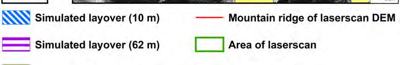
4 Layover & Shadow Radar Shadow Layover
5 Layover & Shadow Radar Shadow Layover


 of the test")


6 Layover-Shadow- Simulation Input data for the simulation Digital Elevation Model (DEM) of the test site Coordinates of the test site Incidence Angle Orbit information: Ascending / Descending Plank et al. 2012
7 Layover-Shadow-Simulation Plank et al. 2012
8 Which part of the movement on the ground is detected by D-InSAR? Measurable percentage of movement depends on: Dip direction of the slope Slope dip Incidence Angle Orbit of the satellite (Asc./ Desc.) SAR detects movements in Range flight direction (Azimuth) No detection of movements Azimuth possible
9 Which part of the movement on the ground is detected by D-InSAR? Horizontal Measurable Percentage of Movement h Asc = cos(90 α ε) h Desc = cos(90 α + ε) Plank et al. 2012
10 Which part of the movement on the ground is detected by D-InSAR? Vertical Measurable Percentage of Movement Slope in SAR viewing direction Slope towards SAR viewing direction m3d = h v v1 = cos(90 θ δ) ) v2 = cos(90 θ + δ) ) Plank et al. 2012
11 Layover-Shadow-Simulation & Measurable Percentage of Movement Plank et al. 2012
12 Influence of the Land Cover Coherence and displacement ϒ t = exp [-8(π/λ)² (σ² y (sin θ)² +σ² σ z (cos θ)²)] )] Modified after ZEBKER & VILLANSENOR (1992)
13 Influence of the Land Cover Coherence and displacement ϒ t = exp [-8(π/λ)² (σ² y (sin θ)² +σ² σ z (cos θ)²)] )] Modified after BORGEAUD & WEGMÜLLER (1997) Modified after ZEBKER & VILLANSENOR (1992)
² (σ² y (sin θ)² +σ² σ z (cos θ)²)] )]")
 Modified after BARBIERI &")
14 Influence of the Land Cover Coherence and displacement ϒ t = exp [-8(π/λ)² (σ² y (sin θ)² +σ² σ z (cos θ)²)] )] Modified after ZEBKER & VILLANSENOR (1992) verändert BORGEAUD & WEGMÜLLER (1997) Modified after BARBIERI & LICHTENEGGER (2005)
15 Influence of the Land Cover Class X-band (3.1 cm) C-band (5.6 cm) L-band (23.6 cm) Continuous urban fabric Discontinuous urban fabric & Infrastructure Rocks Alluvium Pasture Forest Agriculture Water bodies Fast changing areas 6 6 6


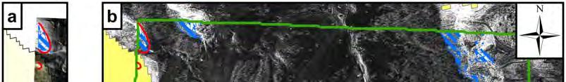
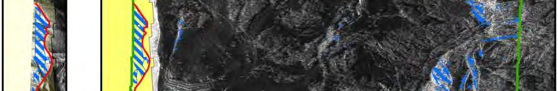
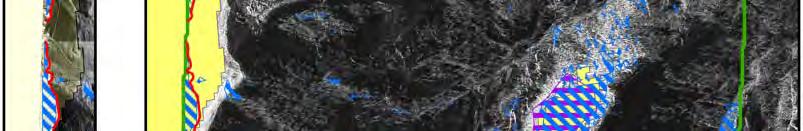
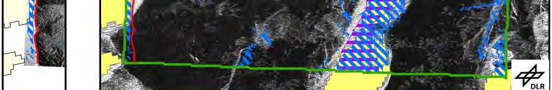
16 Influence of the Land Cover


17 Influence of the Land Cover


18 Influence of the Land Cover


19 Influence of the Land Cover
20 Influence of the Land Cover
21 Influence of the Land Cover
22 Influence of the Land Cover
23 Influence of the Land Cover
24 Geometry & Land Cover Landslides Process of Layover Measurable Mass movement (L), Shadow (S) Percentage of Movement [%] Land Cover X-band C-band L-band Applicability of D-InSAR Landslide Landslide Fall Landslide de Landslide L (100%) Landslide Rock Fall Landslide - 45, Landslide L (70 %) (35 %) 3 (65 %) 4
25 Persistent Scatterer Interferometry Stack: at least 15 to 50 SAR acquisitions required PS: Scatterer of long-term high coherence e.g.: Buildings, Walls, Rocks, etc. PSI: Network of PS Advantage: Avoidance of the coherence problem (D-InSAR) Prerequisite: Number of PS within the test site has to be high enough! Goal: Development and investigation of methods to enable objective pre-survey pesu ey suitability analysis a s Pre-processing


26 Suitability of PSI Test site Satellite Aschau am Inn TerraSAR-X Budapest TerraSAR-X Aosta Valley Radarsat-1 Ivrea Radarsat-1 Omegna Radarsat-1 Varallo Radarsat-1 Domodossola Radarsat-1 Novara Radarsat-1 Cairo ENVISAT Bavaria ERS-1 & 2 Netherlands ERS-1 & 2 North Germany ERS-1 & 2 Plank et al. 2013
27 Estimation of the PS density using land cover data Method Absolute PS density (PS/km²) Aosta Valley Asc. East
28 Estimation of the PS density using land cover data Method Relative PS density (PS/km²) Aosta Valley Asc. East
29 Estimation of the PS density using land cover data Result CORINE 2006 relative PS density Plank et al. 2013


30 Estimation of the PS density using land cover data Validation CORINE 2006 Land Cover Application to Ivrea (Not used in the calibration)


")
 PS")
31 Estimation of the PS density using land cover data Validation Difference of processed (a) and estimated (b) PS density Plank et al. 2013
32 Conclusions Imaging geometry & topographic relief Layover-Shadow-Simulation Calculation of the measurable percentage of movement Influence of Land Cover (SAR wavelength, temporal de-correlation): Classification of the influence of the Land Cover on D-InSAR High number of PS within the test site required: Estimation of the PS density prior to SAR acquisition using free available geo data: Land Cover data
33 Conclusions Size of the landslide (spatial resolution of the SAR, Multi-looking, etc.) Repeat Orbit & velocity of the landslide v λ / 2 Type of movement of the landslide
34 Conclusions - Type of movement: - Fall - Topple - Slide (Rotation, Translation) - Flow (Rock flow, Debris flow) - Spread - Complex - Velocity: D-InSAR GB D-InSAR extreme slow (mm/a), very slow (1m/a), slow (13m/Mon), moderate (1,8m/h), fast (3m/min), very eyfast (5m/s), extreme ete east fast (>5m/s)
35 References - Plank, S., Singer, J., Minet, C. & Thuro, K. (2012): Pre-survey suitability evaluation of the differential synthetic aperture radar interferometry method for landslide monitoring. International Journal of Remote Sensing, 33:20, Plank, S., Singer, J. & Thuro, K. (2013): Assessment of number and distribution of persistent scatterers prior to radar acquisition using open access land cover and topographical p data. ISPRS Journal of Photogrammetry and Remote Sensing, 85,
36 Thank you!
Assessment of number and distribution of persistent scatterers prior to radar acquisition using open access land cover and topographical data
 Assessment of number and distribution of persistent scatterers prior to radar acquisition using open access land cover and topographical data Simon Plank 1*, John Singer 2 and Kurosch Thuro 3 1 German
Improved PSI Performance for Landslide Monitoring Applications. J. Duro, R. Iglesias, P. Blanco-Sánchez, F. Sánchez and D. Albiol
 Improved PSI Performance for Landslide Monitoring Applications J. Duro, R. Iglesias, P. Blanco-Sánchez, F. Sánchez and D. Albiol Outline Area of Study Previous PSI (and others) studies Main conclusions
Surface Deformation Measurements Scientific Requirements & Challenges
 Surface Deformation Measurements Scientific Requirements & Challenges 1st Science and Application Workshop for Germany-Japan Next-Generation SAR M. Eineder, C. Minet, A. Parizzi Tokyo, 27.6.2013 Tandem-L
MODELS TO PREDICT PERSISTENT SCATTERERS DATA DISTRIBUTION AND THEIR CAPACITY TO REGISTER MOVEMENT ALONG THE SLOPE
 MODELS TO PREDICT PERSISTENT SCATTERERS DATA DISTRIBUTION AND THEIR CAPACITY TO REGISTER MOVEMENT ALONG THE SLOPE Notti D., (1) Meisina C. (1), Zucca F. (1) and Colombo A. (2) (1) Dip. Di Scienze della
The financial and communal impact of a catastrophe instantiated by. volcanoes endlessly impact on lives and damage expensive infrastructure every
 Chapter 1 Introduction The financial and communal impact of a catastrophe instantiated by geophysical activity is significant. Landslides, subsidence, earthquakes and volcanoes endlessly impact on lives
APPEARANCE OF PERSISTENT SCATTERERS FOR DIFFERENT TERRASAR-X ACQUISITION MODES
 APPEARANCE OF PERSISTENT SCATTERERS FOR DIFFERENT TERRASAR-X ACQUISITION MODES Stefan Gernhardt a, Nico Adam b, Stefan Hinz c, Richard Bamler a,b a Remote Sensing Technology, TU München, Germany b Remote
Application of satellite InSAR data for hydrocarbon reservoir monitoring
 Application of satellite InSAR data for hydrocarbon reservoir monitoring A. Tamburini, A. Belson, A. Ferretti, F. Novali TRE Milano, Italy Copyright - Tele-Rilevamento Europa - 2004 Outline SqueeSAR TM
THE USE OF DIFFERENT REMOTE SENSING TECHNIQUES FOR LANDSLIDE CHARACTERIZATION
 THE USE OF DIFFERENT REMOTE SENSING TECHNIQUES FOR LANDSLIDE CHARACTERIZATION Ph.D. candidate: ANNA DE AGOSTINI Tutor: Dr. M. FLORIS Cycle: XXVI Abstract The aim of my research is to investigate the potential
Retrieving 3D deformation pattern of a landslide with hiresolution InSAR and in-situ measurements: Just landslide case-study
 Retrieving 3D deformation pattern of a landslide with hiresolution InSAR and in-situ measurements: Just landslide case-study Zbigniew Perski (1), Petar Marinković (2), Yngvar Larsen (3), Tomasz Wojciechowski
Radar Remote Sensing: Monitoring Ground Deformations and Geohazards from Space
 Radar Remote Sensing: Monitoring Ground Deformations and Geohazards from Space Xiaoli Ding Department of Land Surveying and Geo-Informatics The Hong Kong Polytechnic University A Question 100 km 100 km
DEM GENERATION AND ANALYSIS ON RUGGED TERRAIN USING ENVISAT/ASAR ENVISAT/ASAR MULTI-ANGLE INSAR DATA
 DEM GENERATION AND ANALYSIS ON RUGGED TERRAIN USING ENVISAT/ASAR ENVISAT/ASAR MULTI-ANGLE INSAR DATA Li xinwu Guo Huadong Li Zhen State Key Laboratory of Remote Sensing Science, Institute of Remote Sensing
CHAPTER-7 INTERFEROMETRIC ANALYSIS OF SPACEBORNE ENVISAT-ASAR DATA FOR VEGETATION CLASSIFICATION
 147 CHAPTER-7 INTERFEROMETRIC ANALYSIS OF SPACEBORNE ENVISAT-ASAR DATA FOR VEGETATION CLASSIFICATION 7.1 INTRODUCTION: Interferometric synthetic aperture radar (InSAR) is a rapidly evolving SAR remote
Objectives and hypotheses. Remote sensing: applications for landslide hazard assessment and risk management. Ping Lu (University of Firenze) Methods
 Methods") Topical Workshop Remote sensing: applications for landslide hazard assessment and risk management Ping Lu (University of Firenze) Supervisors: Prof. Nicola Casagli; Prof. Filippo Catani (Unifi) Dr. Veronica
Topical Workshop Remote sensing: applications for landslide hazard assessment and risk management Ping Lu (University of Firenze) Supervisors: Prof. Nicola Casagli; Prof. Filippo Catani (Unifi) Dr. Veronica
Department of Geological and Mining Engineering and Sciences Michigan Technological University, Houghton, MI-49931, USA.
 Indian Geotechnical Conference IGC2016 15-17 December 2016, IIT Madras, Chennai, India New Paradigm in Geotechnical Performance Monitoring Using Remote Sensing Thomas Oommen 1, El Hachemi Bouali 1, & Rudiger
USING SAR INTERFEROGRAMS AND COHERENCE IMAGES FOR OBJECT-BASED DELINEATION OF UNSTABLE SLOPES
 USING SAR INTERFEROGRAMS AND COHERENCE IMAGES FOR OBJECT-BASED DELINEATION OF UNSTABLE SLOPES Barbara Friedl (1), Daniel Hölbling (1) (1) Interfaculty Department of Geoinformatics Z_GIS, University of
3D temporal evolution of displacements recorded on Mt. Etna from the 2007 to 2010 through the SISTEM method
 3D temporal evolution of displacements recorded on Mt. Etna from the 2007 to 2010 through the SISTEM method Bonforte A., Guglielmino F.,, Puglisi G. INGV Istituto Nazionale di Gofisica e vulcanologia Osservatorio
PERSISTENT SCATTERER INTERFEROMETRY: POTENTIAL AND LIMITS
 PERSISTENT SCATTERER INTERFEROMETRY: POTENTIAL AND LIMITS M. Crosetto a, O. Monserrat a, A. Jungner, B. Crippa b a Institute of Geomatics, Av. del Canal Olímpic, s/n, Castelldefels, E-08860, Spain (michele.crosetto,
DETECTING ICE MOTION IN GROVE MOUNTAINS, EAST ANTARCTICA WITH ALOS/PALSAR AND ENVISAT/ASAR DATA
 DETECTING ICE MOTION IN GROVE MOUNTAINS, EAST ANTARCTICA WITH ALOS/PALSAR AND ENVISAT/ASAR DATA TIAN Xin (1), LIAO Mingsheng (1), ZHOU Chunxia (2), ZHOU Yu (3) (1) State Key Laboratory of Information Engineering
SAR Data Analysis: An Useful Tool for Urban Areas Applications
 SAR Data Analysis: An Useful Tool for Urban Areas Applications M. Ferri, A. Fanelli, A. Siciliano, A. Vitale Dipartimento di Scienza e Ingegneria dello Spazio Luigi G. Napolitano Università degli Studi
RADAR Remote Sensing Application Examples
 RADAR Remote Sensing Application Examples! All-weather capability: Microwave penetrates clouds! Construction of short-interval time series through cloud cover - crop-growth cycle! Roughness - Land cover,
Application of PSI technique to slope stability monitoring in the Daunia mountains, Italy
 ESA ESRIN - Frascati 28 November- 2 December Application of PSI technique to slope stability monitoring in the Daunia mountains, Italy F. Bovenga (1) (fabio.bovenga@ba.infn.it) L. Guerriero (1) R. Nutricato
The Potential of High Resolution Satellite Interferometry for Monitoring Enhanced Oil Recovery
 The Potential of High Resolution Satellite Interferometry for Monitoring Enhanced Oil Recovery Urs Wegmüller a Lutz Petrat b Karsten Zimmermann c Issa al Quseimi d 1 Introduction Over the last years land
3-Dimension Deformation Mapping from InSAR & Multiaperture. Hyung-Sup Jung The Univ. of Seoul, Korea Zhong Lu U.S. Geological Survey, U.S.A.
 3-Dimension Deformation Mapping from InSAR & Multiaperture InSAR Hyung-Sup Jung The Univ. of Seoul, Korea Zhong Lu U.S. Geological Survey, U.S.A. Outline Introduction to multiple-aperture InSAR (MAI) 3-D
DIFFERENTIAL INSAR STUDIES IN THE BOREAL FOREST ZONE IN FINLAND
 DIFFERENTIAL INSAR STUDIES IN THE BOREAL FOREST ZONE IN FINLAND Kirsi Karila (1,2), Mika Karjalainen (1), Juha Hyyppä (1) (1) Finnish Geodetic Institute, P.O. Box 15, FIN-02431 Masala, Finland, Email:
THE FEASIBILITY AND APPLICATION OF PSI TO DETECT A RANGE OF GROUND AND STRUCTURE MOTION PHENOMENA.
 THE FEASIBILITY AND APPLICATION OF PSI TO DETECT A RANGE OF GROUND AND STRUCTURE MOTION PHENOMENA. Rachel Holley, InSAR Surveying Consultant InSAR Surveying Team Fugro NPA Satellite Mapping Introduction
Atmospheric Water Vapor Effect on GNSS Signals and InSAR Data
 Atmospheric Water Vapor Effect on GNSS Signals and InSAR Data Basic Concept and Preliminary Results F. Alshawaf 1, S. Hinz 1, A. Thiele 1 T. Fuhrmann 2, B. Heck 2, A. Knöpfler 2, X. Luo 2, M. Mayer 2,
GLOBAL FOREST CLASSIFICATION FROM TANDEM-X INTERFEROMETRIC DATA: POTENTIALS AND FIRST RESULTS
 GLOBAL FOREST CLASSIFICATION FROM TANDEM-X INTERFEROMETRIC DATA: POTENTIALS AND FIRST RESULTS Michele Martone, Paola Rizzoli, Benjamin Bräutigam, Gerhard Krieger Microwaves and Radar Institute German Aerospace
 http://topex.ucsd.edu/gmtsar amplitude and phase coherence and pixel matching resolution: optical vs. microwave D s = 2H sinθ r = 2H λ L H = 800km. Optical : L = 1m λ = 0.5µm D s = 0.8m Microwave : L
Urban land and infrastructure deformation monitoring by satellite radar interferometry
 Urban land and infrastructure deformation monitoring by satellite radar interferometry Lei Zhang and Xiaoli Ding Department of Land Surveying and Geo-Informatics (LSGI) The Hong Kong Polytechnic University
Terrafirma Persistent Scatterer Processing Validation
 Terrafirma Persistent Scatterer Processing Validation Nico Adam (1), Alessandro Parizzi (1), Michael Eineder (1), Michele Crosetto () (1) Remote Sensing Technology Institute () Institute of Geomatics Signal
Monitoring of landslide dynamics with LIDAR, SAR interferometry and photogrammetry. Case study of Kłodne landslide (Southern Poland)
") Proceedings of World Landslide Forum 3, 2-6 June 2014, Beijing Monitoring of landslide dynamics with LIDAR, SAR interferometry and photogrammetry. Case study of Kłodne landslide (Southern Poland) Zbigniew
Proceedings of World Landslide Forum 3, 2-6 June 2014, Beijing Monitoring of landslide dynamics with LIDAR, SAR interferometry and photogrammetry. Case study of Kłodne landslide (Southern Poland) Zbigniew
SLOPE STABILITY MONITORING USING SPACE-BORNE REPEAT- PASS SAR INTERFEROMETRY
 SLOPE STABILITY MONITORING USING SPACE-BORNE REPEAT- PASS SAR INTERFEROMETRY Urs WEGMÜLLER 1, Charles WERNER 1, Tazio STROZZI 1, Andreas WIESMANN 1, and Hugo RAETZO 2 1 Gamma Remote Sensing AG, Switzerland
ERS Track 98 SAR Data and InSAR Pairs Used in the Analysis
 ERS Track 98 SAR Data and InSAR Pairs Used in the Analysis Date 1 Date 2 Date 1 Date 2 Date 1 Date 2 Date 1 Date 2 7/17/1992 6/19/2000 7/17/1992 7/2/1993 9/10/1993 10/28/1996 9/3/1995 10/18/1999 9/25/1992
Combining InSAR, Levelling and GNSS for the Estimation of 3D Surface Displacements
 Combining InSAR, Levelling and GNSS for the Estimation of 3D Surface Displacements Thomas Fuhrmann (1), Miguel Caro Cuenca (2), Freek van Leijen (3), Malte Westerhaus (1), Ramon Hanssen (3), Bernhard Heck
ERS-ENVISAT CROSS-INTERFEROMETRY SIGNATURES OVER DESERTS. Urs Wegmüller, Maurizio Santoro and Christian Mätzler
 ERS-ENVISAT CROSS-INTERFEROMETRY SIGNATURES OVER DESERTS Urs Wegmüller, Maurizio Santoro and Christian Mätzler Gamma Remote Sensing AG, Worbstrasse 225, CH-3073 Gümligen, Switzerland, http://www.gamma-rs.ch,
Monitoring of Deformations of Infrastructure Objects by Radar-Interferometry - Prerequisites, Potential and Limitations
 Monitoring of Deformations of Infrastructure Objects by Radar-Interferometry - Prerequisites, Potential and Limitations W. Niemeier, B. Riedel Institute of Geodesy and Photogrammetry, Technische Universität
Application of advanced InSAR techniques for the measurement of vertical and horizontal ground motion in longwall minings
 University of Wollongong Research Online Coal Operators' Conference Faculty of Engineering and Information Sciences 2013 Application of advanced InSAR techniques for the measurement of vertical and horizontal
EXTRACTION OF FLOODED AREAS DUE THE 2015 KANTO-TOHOKU HEAVY RAINFALL IN JAPAN USING PALSAR-2 IMAGES
 EXTRACTION OF FLOODED AREAS DUE THE 2015 KANTO-TOHOKU HEAVY RAINFALL IN JAPAN USING PALSAR-2 IMAGES F. Yamazaki a, *, W. Liu a a Chiba University, Graduate School of Engineering, Chiba 263-8522, Japan
Constructing high-resolution, absolute maps of atmospheric water vapor by combining InSAR and GNSS observations
 Constructing high-resolution, absolute maps of atmospheric water vapor by combining InSAR and GNSS observations Fadwa Alshawaf, Stefan Hinz, Michael Mayer, Franz J. Meyer fadwa.alshawaf@kit.edu INSTITUTE
Analysis of High Resolution Multi-frequency, Multipolarimetric and Interferometric Airborne SAR Data for Hydrologic Model Parameterization
 Analysis of High Resolution Multi-frequency, Multipolarimetric and Interferometric Airborne SAR Data for Hydrologic Model Parameterization Martin Herold 1, Volker Hochschild 2 1 Remote Sensing Research
Measuring rock glacier surface deformation using SAR interferometry
 Permafrost, Phillips, Springman & Arenson (eds) 2003 Swets & Zeitlinger, Lisse, ISBN 90 5809 582 7 Measuring rock glacier surface deformation using SAR interferometry L.W. Kenyi Institute for Digital Image
Effect of Unmodelled Reference Frame Motion on InSAR Deformation Estimates
 Effect of Unmodelled Reference Frame Motion on InSAR Deformation Estimates Hermann Bähr 1, Sami Samiei-Esfahany 2 and Ramon Hanssen 2 1 Karlsruhe Institute of Technology, Germany 2 Delft University of
Application of Net Present Benefit to InSAR Monitoring. Audrey K. Moruza, Virginia Transportation Research Council (VDOT)
") Application of Net Present Benefit to InSAR Monitoring Audrey K. Moruza, Virginia Transportation Research Council (VDOT) 11/27/2017 2 11/27/2017 3 11/27/2017 4 In S A R Interferometric Synthetic Aperture
Application of Net Present Benefit to InSAR Monitoring Audrey K. Moruza, Virginia Transportation Research Council (VDOT) 11/27/2017 2 11/27/2017 3 11/27/2017 4 In S A R Interferometric Synthetic Aperture
to: Interseismic strain accumulation and the earthquake potential on the southern San
 Supplementary material to: Interseismic strain accumulation and the earthquake potential on the southern San Andreas fault system by Yuri Fialko Methods The San Bernardino-Coachella Valley segment of the
Journal of Geodynamics
 Journal of Geodynamics 49 (2010) 161 170 Contents lists available at ScienceDirect Journal of Geodynamics journal homepage: http://www.elsevier.com/locate/jog Recent advances on surface ground deformation
Deformation measurement using SAR interferometry: quantitative aspects
 Deformation measurement using SAR interferometry: quantitative aspects Michele Crosetto (1), Erlinda Biescas (1), Ismael Fernández (1), Ivan Torrobella (1), Bruno Crippa (2) (1) (2) Institute of Geomatics,
ACHIEVING THE ERS-2 ENVISAT INTER-SATELLITE INTERFEROMETRY TANDEM CONSTELLATION.
 ACHIEVING THE ERS-2 ENVISAT INTER-SATELLITE INTERFEROMETRY TANDEM CONSTELLATION M. A. Martín Serrano (1), M. A. García Matatoros (2), M. E. Engdahl (3) (1) VCS-SciSys at ESA/ESOC, Robert-Bosch-Strasse
ALOS PI Symposium 2009, 9-13 Nov 2009 Hawaii MOTION MONITORING FOR ETNA USING ALOS PALSAR TIME SERIES
 ALOS PI Symposium 2009, 9-13 Nov 2009 Hawaii ALOS Data Nodes: ALOS RA-094 and RA-175 (JAXA) MOTION MONITORING FOR ETNA USING ALOS PALSAR TIME SERIES Urs Wegmüller, Charles Werner and Maurizio Santoro Gamma
High-resolution temporal imaging of. Howard Zebker
 High-resolution temporal imaging of crustal deformation using InSAR Howard Zebker Stanford University InSAR Prehistory SEASAT Topographic Fringes SEASAT Deformation ERS Earthquake Image Accurate imaging
Implementation of Multi-Temporal InSAR to monitor pumping induced land subsidence in Pingtung Plain, Taiwan
 Implementation of Multi-Temporal InSAR to monitor pumping induced land subsidence in Pingtung Plain, Taiwan Presenter: Oswald Advisor: Chuen-Fa Ni Date: March 09, 2017 Literature Review Pingtung Plain
ANALYSIS OF ASAR POLARISATION SIGNATURES FROM URBAN AREAS (AO-434)
") ANALYSIS OF ASAR POLARISATION SIGNATURES FROM URBAN AREAS (AO-434) Dan Johan Weydahl and Richard Olsen Norwegian Defence Research Establishment (FFI), P.O. Box 25, NO-2027 Kjeller, NORWAY, Email: dan-johan.weydahl@ffi.no
ANALYSIS OF ASAR POLARISATION SIGNATURES FROM URBAN AREAS (AO-434) Dan Johan Weydahl and Richard Olsen Norwegian Defence Research Establishment (FFI), P.O. Box 25, NO-2027 Kjeller, NORWAY, Email: dan-johan.weydahl@ffi.no
ERAD Water vapor observations with SAR, microwave radiometer and GPS: comparison of scaling characteristics
 Proceedings of ERAD (2002): 190 194 c Copernicus GmbH 2002 ERAD 2002 Water vapor observations with SAR, microwave radiometer and GPS: comparison of scaling characteristics D. N. Moisseev 1, R. F. Hanssen
DLR s TerraSAR-X contributes to international fleet of radar satellites to map the Arctic and Antarctica
 DLR s TerraSAR-X contributes to international fleet of radar satellites to map the Arctic and Antarctica The polar regions play an important role in the Earth system. The snow and ice covered ocean and
Advanced interpretation of land subsidence by validating multiinterferometric SAR data: the case study of Anthemountas basin (Northern Greece)
") Revision of paper Advanced interpretation of land subsidence by validating multiinterferometric SAR data: the case study of Anthemountas basin (Northern Greece) By Raspini et al. General comments This
Revision of paper Advanced interpretation of land subsidence by validating multiinterferometric SAR data: the case study of Anthemountas basin (Northern Greece) By Raspini et al. General comments This
Investigating landslides with space-borne Synthetic Aperture Radar (SAR) interferometry
 interferometry") Engineering Geology 88 (2006) 173 199 www.elsevier.com/locate/enggeo Investigating landslides with space-borne Synthetic Aperture Radar (SAR) interferometry Carlo Colesanti 1, Janusz Wasowski a, a CNR-IRPI,
Engineering Geology 88 (2006) 173 199 www.elsevier.com/locate/enggeo Investigating landslides with space-borne Synthetic Aperture Radar (SAR) interferometry Carlo Colesanti 1, Janusz Wasowski a, a CNR-IRPI,
Evaluation of subsidence from DinSAR techniques using Envisat-ASAR data at Toluca Valley Basin, Mexico.
 Evaluation of subsidence from DinSAR techniques using Envisat-ASAR data at Toluca Valley Basin, Mexico. Norma Angélica Dávila Hernández 1 Delfino Madrigal Uribe 1 Xanat Antonio Némiga 1 1 Autonomous University
Tandem-L: A Mission Proposal for Monitoring Dynamic Earth Processes
 Tandem-L: A Mission Proposal for Monitoring Dynamic Earth Processes A. Moreira, G. Krieger, M. Younis, I. Hajnsek, K. Papathanassiou, M. Eineder, P. Dekker, F. De Zan German Aerospace Center (DLR) Dynamic
LAND COVER CLASSIFICATION BASED ON SAR DATA IN SOUTHEAST CHINA
 LAND COVER CLASSIFICATION BASED ON SAR DATA IN SOUTHEAST CHINA Mr. Feilong Ling, Dr. Xiaoqin Wang, Mr.Xiaoming Shi Fuzhou University, Level 13, Science Building,No.53 Gongye Rd., 35, Fuzhou, China Email:
Model based forest height estimation with ALOS/PalSAR: A first study.
 Model based forest height estimation with ALOS/PalSAR: A first study. K.P. Papathanassiou*, I. Hajnsek*, T.Mette*, S.R. Cloude** and A. Moreira* * (DLR) (DLR-HR) Oberpfaffenhofen, Germany ** AEL Consultants
Multi-temporal archaeological and environmental prospection in Nasca (Peru) with ERS-1/2, ENVISAT and Sentinel-1A C-band SAR data
 with ERS-1/2, ENVISAT and Sentinel-1A C-band SAR data") 12-13 November 215 ESA-ESRIN, Frascati (Rome), Italy Day 1 Session: Historical Landscapes and Environmental Analysis Multi-temporal archaeological and environmental prospection in Nasca (Peru) with ERS-1/2,
12-13 November 215 ESA-ESRIN, Frascati (Rome), Italy Day 1 Session: Historical Landscapes and Environmental Analysis Multi-temporal archaeological and environmental prospection in Nasca (Peru) with ERS-1/2,
MAPPING DEFORMATION OF MAN-MADE LINEAR FEATURES USING DINSAR TECHNIQUE
 MAPPING DEFORMATION OF MAN-MADE LINEAR FEATURES USING DINSAR TECHNIQUE H. Wu a, *, Y. Zhang a, J. Zhang a, X. Chen b a Key Laboratory of Mapping from Space of State Bureau of Surveying and Mapping, Chinese
Speaker: Ing. Giorgio Barsacchi. Kinematics of the Slumgullion Landslide Revealed by Ground based InSAR Surveys
 Kinematics of the Slumgullion Landslide revealed by Ground based InSAR Survey Speaker: Ing. Giorgio Barsacchi Giorgio Barsacchi Kinematics of the Slumgullion Landslide Revealed by Ground based InSAR Surveys
Available online at GHGT-9. Detection of surface deformation related with CO 2 injection by DInSAR at In Salah, Algeria
 Available online at www.sciencedirect.com Energy Procedia 100 (2009) (2008) 2177 2184 000 000 Energy Procedia www.elsevier.com/locate/procedia www.elsevier.com/locate/xxx GHGT-9 Detection of surface deformation
The Tohoku Earthquake 2011 Case.
 Wide Area Deformation map generation with TerraSAR-X Data. The Tohoku Earthquake 2011 Case. N. Yague-Martinez (1), C. Minet (2), M. Eineder (2), B. Schättler (2) (1) Starlab, Spain (2) Remote Sensing Technology
VALIDATION OF THE PERMANENT SCATTERERS TECHNIQUE IN URBAN AREAS
 VALIDATION OF THE PERMANENT SCATTERERS TECHNIQUE IN URBAN AREAS Alessandro Ferretti, Claudio Prati, Fabio Rocca, Carlo Colesanti Dipartimento di Elettonica e Informazione Politecnico di Milano Piazza L.
Pilot service: Southern Emilia Romagna (Italy)
") Pilot service: Southern Emilia Romagna (Italy) Surface deformation service provider (PSInSAR TM ) Geodetic and optical remote sensing data integration Final user The study area The Southern Emilia-Romagna
Pilot service: Southern Emilia Romagna (Italy) Surface deformation service provider (PSInSAR TM ) Geodetic and optical remote sensing data integration Final user The study area The Southern Emilia-Romagna
TEMPORAL VARIABILITY OF ICE FLOW ON HOFSJÖKULL, ICELAND, OBSERVED BY ERS SAR INTERFEROMETRY
 TEMPORAL VARIABILITY OF ICE FLOW ON HOFSJÖKULL, ICELAND, OBSERVED BY ERS SAR INTERFEROMETRY Florian Müller (1), Helmut Rott (2) (1) ENVEO IT, Environmental Earth Observation GmbH, Technikerstrasse 21a,
Snow Water Equivalent (SWE) of dry snow derived from InSAR -theory and results from ERS Tandem SAR data
 of dry snow derived from InSAR -theory and results from ERS Tandem SAR data") Snow Water Equivalent (SWE) of dry snow derived from InSAR -theory and results from ERS Tandem SAR data Tore Guneriussen, Kjell Arild Høgda, Harald Johnsen and Inge Lauknes NORUT IT Ltd., Tromsø Science
Snow Water Equivalent (SWE) of dry snow derived from InSAR -theory and results from ERS Tandem SAR data Tore Guneriussen, Kjell Arild Høgda, Harald Johnsen and Inge Lauknes NORUT IT Ltd., Tromsø Science
ERS-ENVISAT Cross-interferometry for Coastal DEM Construction
 ERS-ENVISAT Cross-interferometry for Coastal DEM Construction Sang-Hoon Hong and Joong-Sun Won Department of Earth System Sciences, Yonsei University, 134 Shinchon-dong, Seodaemun-gu, 120-749, Seoul, Korea
Mitigation of Atmospheric Water-vapour Effects on Spaceborne Interferometric SAR Imaging through the MM5 Numerical Model
 PIERS ONLINE, VOL. 6, NO. 3, 2010 262 Mitigation of Atmospheric Water-vapour Effects on Spaceborne Interferometric SAR Imaging through the MM5 Numerical Model D. Perissin 1, E. Pichelli 2, R. Ferretti
AlOS-PALSAR data for Landslide Monitoring and Geological Mapping
 AlOS-PALSAR data for Landslide Monitoring and Geological Mapping Vern Singhroy, P-J Alasset, G Pavlic Canada Centre for Remote Sensing Ottawa, Canada vern.singhroy@ccrs.nrcan.gc.ca Objectives InSAR monitoring
J. Manuel Delgado (1,2), Roberto Cuccu (1), Giancarlo Rivolta (1)
, Roberto Cuccu (1), Giancarlo Rivolta (1)") MONITORING GROUND DEFORMATION USING PERSISTENT SCATTERS INTERFEROMETRY (PSI) AND SMALL BASELINES (SBAS) TECHNIQUES INTEGRATED IN THE ESA RSS SERVICE: THE CASE STUDY OF VALENCIA, ROME AND SOUTH SARDINIA
MONITORING GROUND DEFORMATION USING PERSISTENT SCATTERS INTERFEROMETRY (PSI) AND SMALL BASELINES (SBAS) TECHNIQUES INTEGRATED IN THE ESA RSS SERVICE: THE CASE STUDY OF VALENCIA, ROME AND SOUTH SARDINIA
Haiti Earthquake (12-Jan-2010) co-seismic motion using ALOS PALSAR
 co-seismic motion using ALOS PALSAR") Haiti Earthquake (12-Jan-2010) co-seismic motion using ALOS PALSAR Urs Wegmüller, Charles Werner, Maurizio Santoro Gamma Remote Sensing, CH-3073 Gümligen, Switzerland SAR data: JAXA, METI; PALSAR AO Project
Haiti Earthquake (12-Jan-2010) co-seismic motion using ALOS PALSAR Urs Wegmüller, Charles Werner, Maurizio Santoro Gamma Remote Sensing, CH-3073 Gümligen, Switzerland SAR data: JAXA, METI; PALSAR AO Project
Terrafirma monitoring and mapping landslide services for Europe based on InSAR satellite data
 Department of Earth Sciences CENTRE OF COMPETENCE OF THE CIVIL PROTECTION DEPARTMENT PRESIDENCY OF THE COUNCIL OF MINISTERS Terrafirma monitoring and mapping landslide services for Europe based on InSAR
USE OF INTERFEROMETRIC SATELLITE SAR FOR EARTHQUAKE DAMAGE DETECTION ABSTRACT
 USE OF INTERFEROMETRIC SATELLITE SAR FOR EARTHQUAKE DAMAGE DETECTION Masashi Matsuoka 1 and Fumio Yamazaki 2 ABSTRACT Synthetic Aperture Radar (SAR) is one of the most promising remote sensing technologies
Landslide Monitoring in Three Gorges Area By Joint Use of Phase Based and Amplitude Based Methods
 Landslide Monitoring in Three Gorges Area By Joint Use of Phase Based and Amplitude Based Methods Xuguo Shi, Lu Zhang, Mingsheng Liao, Timo Balz LIESMARS, Wuhan University Outlines Introduction InSAR Results
NOTES AND CORRESPONDENCE Segmented Faulting Process of Chelungpu Thrust: Implication of SAR Interferograms
 , Vol. 14, No.2, 241-247, June 2003 NOTES AND CORRESPONDENCE Segmented Faulting Process of Chelungpu Thrust: Implication of SAR Interferograms Chien-Chih Chen 1,*, Chung-Pai Chang 2, and Kun-Shan Chen
SAR interferometry Status and future directions. Rüdiger Gens
 SAR interferometry Status and future directions Rüdiger Gens Polarimetric InSAR Polarimetric InSAR InSAR - Status and future directions sensitivity to changes in surface scattering, even in the presence
estimated by InSAR, and the temporal evolution of the deformation and possible cause.
 QUANTIFICATION OF SUBSIDENCE RATES ASSOCIATED WITH GROUNDWATER FLOW USING SAR INTERFEROMETRY J. Catalao (1), G. Nico (2), V. Conde (1), J.M. Miranda (1) (1) IDL, Universidade Lisboa, Campo Grande, Portugal,
EasyChair Preprint. Height Accuracy and Data Coverage for the Final Global TanDEM-X DEM Data
 EasyChair Preprint 123 Height Accuracy and Data Coverage for the Final Global TanDEM-X DEM Data Christopher Wecklich, Carolina Gonzalez and Paola Rizzoli EasyChair preprints are intended for rapid dissemination
Ice & Snow Session. Chairs: J. Mouginot & N. Gourmelen
 Ice & Snow Session Chairs: J. Mouginot & N. Gourmelen Session 12 talks and 10 posters Antarctic ice motion, ground-line detection and monitoring, dynamics ice-fluctuations in Antarctica and Greenland,
Outline. Remote Sensing, GIS and DEM Applications for Flood Monitoring. Introduction. Satellites and their Sensors used for Flood Mapping
 Outline Remote Sensing, GIS and DEM Applications for Flood Monitoring Prof. D. Nagesh Kumar Chairman, Centre for Earth Sciences Professor, Dept. of Civil Engg. Indian Institute of Science Bangalore 560
GEOMORPHOLOGICAL MAPPING WITH RESPECT TO AMPLITUDE, COHERENCEAND PHASE INFORMATION OF ERS SAR TANDEM PAIR
 GEOMORPHOLOGICAL MAPPING WITH RESPECT TO AMPLITUDE, COHERENCEAND PHASE INFORMATION OF ERS SAR TANDEM PAIR AUNG LWIN Assistant Researcher Remote Sensing Department Mandalay Technological University, Myanmar
Blanca Payàs 1, Ryan Morris 2, Alain Arnaud 1, David Albiol 1, John Bradshaw 3, Javier Duro 1. Abstract
 Surface monitoring using radar satellite images to measure ground deformation: applied to Coal Seam Gas production areas to comply with regulatory requirements Blanca Payàs 1, Ryan Morris 2, Alain Arnaud
Estimation of Velocity of the Polar Record Glacier, Antarctica Using Synthetic Aperture Radar (SAR)
") Proceedings Estimation of Velocity of the Polar Record Glacier, Antarctica Using Synthetic Aperture Radar (SAR) Prashant H. Pandit 1, *, Shridhar D. Jawak 2 and Alvarinho J. Luis 2 1 Department of Natural
Proceedings Estimation of Velocity of the Polar Record Glacier, Antarctica Using Synthetic Aperture Radar (SAR) Prashant H. Pandit 1, *, Shridhar D. Jawak 2 and Alvarinho J. Luis 2 1 Department of Natural
CLOSE FORMATION FLIGHT OF PASSIVE RECEIVING MICRO-SATELLITES
 CLOSE FORMATION FLIGHT OF PASSIVE RECEIVING MICRO-SATELLITES Hauke Fiedler (1) and Gerhard Krieger (2) (1) DLR, HR, Weßling, Germany, E-mail:hauke.fiedler@dlr.de (2) DLR, HR, Weßling, Germany, E-mail:gerhard.krieger@dlr.de
Making a case for full-polarimetric radar remote sensing
 Making a case for full-polarimetric radar remote sensing Jeremy Nicoll Alaska Satellite Facility, University of Alaska Fairbanks 1 Polarization States of a Coherent Plane Wave electric field vector vertically
Infrastructure monitoring using SAR interferometry
 Infrastructure monitoring using SAR interferometry Hossein Nahavandchi Roghayeh Shamshiri Norwegian University of Science and Technology (NTNU), Department of Civil and Environmental Engineering Geodesy
LANDSLIDE IDENTIFICATION, MOVEMENT MONITORING AND RISK ASSESSMENT USING ADVANCED EARTH OBSERVATION TECHNIQUES
 LANDSLIDE IDENTIFICATION, MOVEMENT MONITORING AND RISK ASSESSMENT USING ADVANCED EARTH OBSERVATION TECHNIQUES European Leader Investigator Dr. Zbigniew Perski Carpathian Branch, Polish Geological Institute
DAMAGE DETECTION OF THE 2008 SICHUAN, CHINA EARTHQUAKE FROM ALOS OPTICAL IMAGES
 DAMAGE DETECTION OF THE 2008 SICHUAN, CHINA EARTHQUAKE FROM ALOS OPTICAL IMAGES Wen Liu, Fumio Yamazaki Department of Urban Environment Systems, Graduate School of Engineering, Chiba University, 1-33,
DETECTION OF CRUSTAL MOVEMENTS IN THE 2011 TOHOKU, JAPAN EARTHQUAKE USING HIGH-RESOLUTION SAR DATA
 Paper No. M-5 DETECTION OF CRUSTAL MOVEMENTS IN THE 2011 TOHOKU, JAPAN EARTHQUAKE USING HIGH-RESOLUTION SAR DATA Fumio Yamazaki 1 and Wen Liu 2 SUMMARY Significant crustal movements were caused by the
PERSISTENT SCATTERER SAR INTERFEROMETRY APPLICATIONS ON LANDSLIDES IN CARPATHIANS (SOUTHERN POLAND)
") Acta Geodyn. Geomater., Vol. 7, No. 3 (159), 1 7, 2010 PERSISTENT SCATTERER SAR INTERFEROMETRY APPLICATIONS ON LANDSLIDES IN CARPATHIANS (SOUTHERN POLAND) Zbigniew PERSKI 1) *, Tomasz WOJCIECHOWSKI 1)
Acta Geodyn. Geomater., Vol. 7, No. 3 (159), 1 7, 2010 PERSISTENT SCATTERER SAR INTERFEROMETRY APPLICATIONS ON LANDSLIDES IN CARPATHIANS (SOUTHERN POLAND) Zbigniew PERSKI 1) *, Tomasz WOJCIECHOWSKI 1)
ACCURACY ASSESSMENT OF DIGITAL HEIGHT MODELS DERIVED FROM AIRBORNE SYNTHETIC APERTURE RADAR
 ACCURACY ASSESSMENT OF DIGITAL HEIGHT MODELS DERIVED FROM AIRBORNE SYNTHETIC APERTURE RADAR A. Kleusberg and H.G. Klaedtke Institut für Navigation, Universität Stuttgart Geschwister-Scholl-Str. 24D, 7174
InSAR, structural analyses and dating of Paka volcanic products, Northern Kenya Rift
 Andrea Friese InSAR, structural analyses and dating of Paka volcanic products, Northern Kenya Rift Final Report TECHNICAL COOPERATION PROJECT NO.: 2009.2222.9 FEDERAL INSTITUTE FOR GEOSCIENCES AND NATURAL
Polar Space Task Group Permafrost Review of Requirements, Achievements and Expected Data
 Permafrost Review of Requirements, Achievements and Expected Data Annett Bartsch HORIZON2020 project NUNATARYUK (lead AWI with focus on coastal erosion and infrastructure) Dedicated Pleiades acquisitions
IEEE GEOSCIENCE AND REMOTE SENSING LETTERS, VOL. 11, NO. 8, AUGUST
 IEEE GEOSCIENCE AND REMOTE SENSING LETTERS, VOL. 11, NO. 8, AUGUST 2014 1355 Multitemporal Multitrack Monitoring of Wetland Water Levels in the Florida Everglades Using ALOS PALSAR Data With Interferometric
SAR APPLICATIONS IN GREECE With emphasis for Harokopio University/ Dep. of Geography activities
 SAR APPLICATIONS IN GREECE With emphasis for Harokopio University/ Dep. of Geography activities Issaak Parcharidis, Assist. Prof. Harokopio University of Athens Department of Geography parchar@hua.gr 4
Università di Roma La Sapienza, Facoltà d Ingegneria, Dipartimento di Idraulica,Trasporti e Strade (D.I.T.S.) 00185, Roma, Italy
 00185, Roma, Italy") DORIS FP7-EU PROJECT: EXPLOITATION OF 20 YEARS DINSAR DATA ARCHIVE FOR LANDSLIDE MONITORING Manunta M. (1), Calò F. (1), Paglia L., (1), Bonano M. (1,2), Lanari R. (1) (1) IREA-CNR, Via Diocleziano 328,
DORIS FP7-EU PROJECT: EXPLOITATION OF 20 YEARS DINSAR DATA ARCHIVE FOR LANDSLIDE MONITORING Manunta M. (1), Calò F. (1), Paglia L., (1), Bonano M. (1,2), Lanari R. (1) (1) IREA-CNR, Via Diocleziano 328,
PROVENCE INTER-COMPARISON. Marta Agudo, Michele Crosetto Institute of Geomatics
 PROVENCE INTER-COMPARISON Marta Agudo, Michele Crosetto Institute of Geomatics Final version Castelldefels, 16 March 2007 INDEX INDEX... 2 1. INTRODUCTION... 3 2. PRE-PROCESSING STEPS... 5 2.1 Input data...
GEOGRAPHICAL DATABASES FOR THE USE OF RADIO NETWORK PLANNING
 GEOGRAPHICAL DATABASES FOR THE USE OF RADIO NETWORK PLANNING Tommi Turkka and Jaana Mäkelä Geodata Oy / Sanoma WSOY Corporation Konalantie 6-8 B FIN-00370 Helsinki tommi.turkka@geodata.fi jaana.makela@geodata.fi