GEOMATICS ENGINEERING / SURVEYING
|
|
|
- Jane Davis
- 6 years ago
- Views:
Transcription
1 1 GEOMATICS ENGINEERING / SURVEYING CHAPTER 1 Dr. Muhammad Ashraf Javid Assistant Professor Department of Civil and Environmental Engineering muhammad.javid@unizwa.edu.om
2 2 Geomatics Engineering / Surveying Credit Hours (2+1) = 3.0 Assessment policy Quizzes (10%) Assignments (10%) 2 weeks will be given for each assignment and late assignments will not be entertained for any reason. Lab. Work (20%) In-Semester exams (30%) Final exam (30%)
3 3 Course Description The course covers introduction to geomatics engineering, distance measurement, leveling, angle measurement, indirect distance measurement, topographic surveying areas and volumes, construction surveying and road curve preparation and practical.
4 4 Course Contents Introduction of Geomatics engineering Coordinate systems and scales Distance measurement Angle measurement and traversing Leveling Road curve design Area and earthworks calculation Construction and topographic surveying
5 5 Chapter 1 contents Introduction Role of surveying in civil engineering Classification of surveying Basic Principles of Surveying Coordinate systems Sources of Errors
6 6 Introduction to Geomatics Engineering Geomatics It is the discipline of gathering, storing, processing, and delivering geographic or spatial information. Surveying The discipline encompassing all methods of gathering and processing information about our physical earth and its environment. Or The art of making measurements of the relative positions of natural and manmade features on the Earth s surface, and the presentation of this information either graphically or numerically. Geodesy Geodesy is the discipline that deals with the measurements and representation of the Earth, including its gravity field, in a three-dimensional time varying space. Geodesy focus on the Earth and neglect any man-made features on it (e.g. buildings, public utilities, etc.), while surveying use the results of geodesy for positioning and mapping of these features.


 to")


7 The role of Surveying in Civil Engineering Practice Surveyors are needed: to maintain the geometric order during the construction process to provide fundamental data for the design and planning process to provide quantity control during the construction process (for example: earthwork quantities) to monitor the structure after the construction ( deformations, etc.) 7 Wrong geometry the structure is not functional! What is this? Laying them in the appropriate geometry, outstanding structures can be created!
8 The role of Surveying in Civil Engineering Practice Surveying activities during the construction process 8 Before Construction Under construction After construction Planning and data collection Setting out on each phase of construction Final (as-built) plan or map on the construction Observations in the field Processing the observations (office) Drawing maps, plans or providing numerical data Field checks of construction Providing data and services to the client Presenting documentation to the client Deformation Monitoring/ Load Tests Presenting documentation to the client
9 Plane Surveying 9 Primary Classification of Surveying According to the space involved: Relatively small areas (Generally areas < 250 Km 2 ) Surface of earth can supposed to be flat Measurements plotted represent a horizontal projection of the actual field measurements All Z dimensions are referenced to the mean surface of the earth or MSL Plane surface Plane triangle Plane angles most engineering and property surveys are classed as plane surveys, although some route surveys that cover long distances (e.g., highways and railways) will have corrections applied at regular intervals.

10 Geodetic Surveying 10 Primary Classification of Surveying Large areas Surface of the Earth can not supposed to be flat The curvature of the Earth is taken into account Curved line Spherical triangle Spherical angles Don t forget! Size does matter! Mostly used for establishing control networks, determining the size and shape of the Earth and determining the gravity field of the Earth.
11 11 Secondary Classification of Surveying Based on instruments. Based on methods Triangulation surveying Traverse surveying Based on object Geological surveying Mine surveying Archeological surveying Military surveying Based on nature of field Land surveying Marine surveying Astronomical surveying
12 12 Secondary Classification of Surveying Types of Land Surveying Cadastral Surveying Boundary surveying (conducted to determine the boundaries of fields, houses) Construction Surveying Engineering surveys (done to prepare detailed drawings of projects) Topographic Surveying Ground-based mapping (done to determine natural features) City Surveying Carried out to locate the premises, streets, water supply and sanitary systems Hydrographic Surveying Involving water bodies Geodetic Surveying Locating points in space Photogrammetric Surveying Aerial surveys
13 Surveying Classification Topographical Survey Topographical survey is concerned with the measurement of natural and artificial features of the earth s surface in order that a map of these features may be drawn and printed. The methods are similar to geodetic methods but are carried out to a lower order of accuracy. Cadastral Surveying It is the process of defining, demarcating, measuring and recording the boundaries of properties. Where these boundaries are formed by physical features, it overlaps with topographical surveying. As a general rule, cadastral work is done at larger scales than topographical mapping Engineering or Construction Surveys Engineering Surveys are those conducted with the special object of supplying particular information for engineering projects. They are usually at larger scales than topographical maps, but the methods used are often similar. Sometimes a high order of accuracy is required, for example, the measuring of a gap for a bridge. 13
14 14 Basic Principles of Surveying 1. To work from whole to the part Whole area is first enclosed by main stations (i.e. controlling stations) and main survey lines (i.e. controlling lines) Then area is divided into parts by forming well-conditioned triangles Main survey lines are measured very accurately and then the sides of the triangles are measured. Main purpose is to avoid accumulation of error in measurements. 2. To locate a new station by at least two measurements (linear or angular) from fixed reference points. Linear measurements refer to horizontal distances Angular measurements refer to the magnetic bearing or horizontal angle

15 Basic Principles of Surveying 15
16 16 Basic Principles of Surveying Recall the definition of Surveying: The art of making measurements of the relative positions of natural and man-made features on the Earth s surface, and the presentation of this information either graphically or numerically. How to achieve this? Let s determine the position (X P, Y P ) of point P! The positioning is usually separated into horizontal (2D) and vertical (1D) positioning. Nowadays 3D positioning can be achieved using satellite techniques, too. Absolute vs Relative positioning Y X P P d AP Y P d BP B (X B,Y B ) Control points (known coords; marked on the field) A (X A,Y A ) l AB X
17 17 Basic Principles of Surveying Let s determine the position of a third, unknown point (P). We have two unknowns: X P, Y P We need two measurements: b two distances a Y one distance and an angle two angles P d BP a a d AP d AP b B (X B,Y B ) A (X A,Y A ) X
18 18 Basic Principles of Surveying Unknown point Unknown point Unknown point b C C C L AC? L BC? L AC? θ 1? θ 2? θ 1? A B A B A B Known length AB Known length AB Known length AB Fig. 1 Fig. 2 Fig. 3
19 19 Triangulation It is one of the methods of providing control in an area which is to be surveyed It is based on the Trigonometric proposition that if one side and three angles of a Triangle are known, the remaining sides can be computed by the application of Sine-Rule i.e.
20 20 Base Line AB is measured. Internal angles at A, B, C are measured. C D A B
21 21 Traverse A traverse consists of a connected series of lines on earths surface, the length and bearings of which have been determined. Following measurements are made:- a. Horizontal Angles b. Vertical Angles c. Distances d. Bearings Traverse Legs E D Traverse Stations A C
22 22 Trilateration Trilateration methods involve the determination of locations of controls points by measurement of distances, using the geometry of triangles. In contrast to triangulation it does not involve the measurement of angles. c a d b


23 How to create a countrywide coordinate system? In order to use the relative positioning, a proper number of control points are needed. These points: are coordinated points; are marked. 23
, where the common coordinate system (reference system) should be available. The Control Network provide us with control points given in the same refence system (coordinate system).")
24 Control Networks 24 Why is it necessary to have a common countrywide coordinate system? Many engineering tasks cover a large area (highways, bridges, tunnels, channels, land registry, etc.), where the common coordinate system (reference system) should be available. The Control Network provide us with control points given in the same refence system (coordinate system). Thus measuring the relative positions of unknown points using these control points, the coordinates of the new points can be computed in the same reference system.

25 One of the Ground Control Points Established with Promark 3 for Mapping Project 25

26 26 Coordinate Systems-Basics Basic elements of a coordinate system an origin, then the location of every other point can be stated in terms of a defined direction and a distance in the direction
27 27 Coordinate Systems - Basics Coordinate System can be 2D or 3D Types of coordinate systems (1) Geographic coordinates (f, l, z) (2) Global Cartesian coordinates (x, y, z): A system for the whole earth (3) Projected coordinates (x, y, z) on a local area of the earth s surface The z-coordinate in (2) and (3) is defined geometrically, and in (1) the z-coordinate is defined gravitationally.

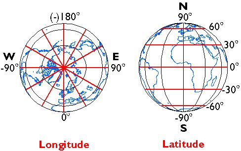
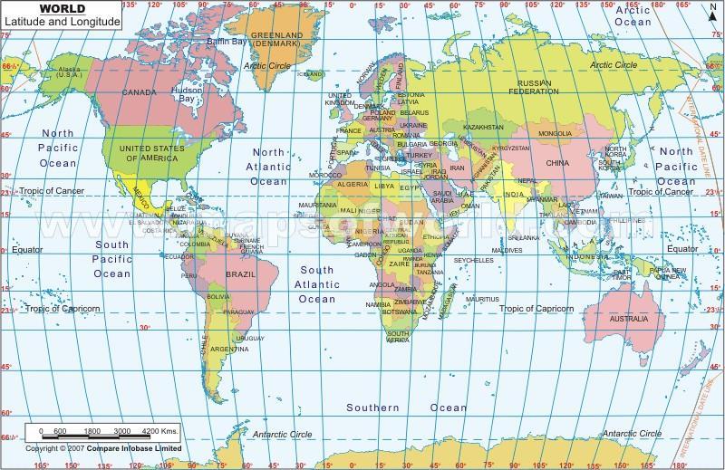
28 28 Coordinate Systems-Basics The most widely used global coordinate system consists of lines of geographic latitude (phi) and longitude (lambda). Lines of equal latitude are called parallels. They form circles on the surface of the ellipsoid. Lines of equal longitude are called meridians and they form ellipses (meridian ellipses) on the ellipsoid The equator is the largest circle and divides the earth in half. The prime meridian is the line of longitude that passes through Greenwich England and defines the origin (zero degrees) for longitude coordinates.
, and increases towards the two poles to maximum values of f = +90 (90 N) at the North Pole and f = - 90 (90 S) at the South Pole.")
29 Coordinate 29 Systems-Basics The latitude (f) of a point P is the angle between the ellipsoidal normal through P and the equatorial plane. Latitude is zero on the equator (f = 0 ), and increases towards the two poles to maximum values of f = +90 (90 N) at the North Pole and f = - 90 (90 S) at the South Pole. z The longitude (λ) is the angle between prime meridian ellipse and the meridian ellipse containing the point P. It is measured in the equatorial plane from the meridian of Greenwich (λ = 0 ) either eastwards through λ = (180 E) or westwards through λ = (180 W).
30 30 Coordinate Systems-Basics
31 Coordinate Systems-Basics
32 32 3D Geographic coordinates (f, l, z) 3D geographic coordinates (f, l, z) are obtained by introducing the ellipsoidal height z to the system. The ellipsoidal height (z) of a point is the vertical distance of the point in question above the ellipsoid. It is measured in distance units along the ellipsoidal normal from the point to the ellipsoid surface. z 3D geographic coordinates can be used to define a position on the surface of the Earth (point P in figure).

33 Angle Vs Distances on surface of earth At equator Circumference of earth=40, kilometers Angle cover in circle=360 o Therefore; 1 degree represents approximately 111 km

34 34 3D Cartesian coordinates/ Geocentric coordinates An alternative method of defining a 3D position on the surface of the Earth is by means of geocentric coordinates (x,y, z), also known as 3D Cartesian coordinates. The system has its origin at the masscentre of the Earth with the X- and Y- axes in the plane of the equator. The X-axis passes through the meridian of Greenwich, and the Z-axis coincides with the Earth's axis of rotation. The three axes are mutually orthogonal and form a right-handed system. Geocentric coordinates can be used to define a position on the surface of the Earth (point P in figure).
 to planar coordinates The basis for this transformation is the geographic")
 Curved Earth Geographic coordinates: f, l (Latitude &")
35 Projected Coordinate Systems A map projection is the systematic transformation of locations on the earth (latitude/longitude) to planar coordinates The basis for this transformation is the geographic coordinate system (which references a datum) Map projections are designed for specific purposes Flat Map Cartesian coordinates: x,y (Easting & Northing) Curved Earth Geographic coordinates: f, l (Latitude & Longitude)

36 The proportion which the distance between any two points on map bears to the horizontal distance between the same two points on the ground. Scale
37 Methods of Expressing Scale IN WORDS Words explain the distance on map that represents a certain distance on ground. e.g 1 Inch or 1 cm =1 Mile etc. BY REPRESENTATIVE FRACTION The distance on map is represented by a fraction of corresponding distance on ground. e.g 1:50,000, 1/10,000 etc. BY SCALE LINE By drawing a scale line showing the digits or parts for measuring distance on the map.
38 38 Errors in Measurements Errors in measurements Sources of errors Natural causes Instrumental imperfections Personal limitations Types of errors Systematic or cumulative Systematic errors can be calculated and proper corrections are applied to the observation. Accidental, random or compensating

 refers to the closeness with which the")
39 39 Precision and Accuracy of Measurements True value of a quantity is never known Accuracy is the closeness or nearness of the measurements to the true value of quantity being measured. Precision (or repeatability) refers to the closeness with which the measurements agree with each other.
Surveying I. Unit - I. Different methods and instruments are being used to facilitate the work of
 Surveying I Unit - I Definition of Survey Surveying is the art of determining the relative positions of different objects on the surface of the earth by measuring the horizontal distances between them,
LECTURE NOTE ENGINEERING SURVEYING
 LECTURE NOTE ENGINEERING SURVEYING LECTURE 1 Introduction: Surveying is defined as taking a general view of, by observation and measurement determining the boundaries, size, position, quantity, condition,
SURVEYING Chapter 1 Introduction
 PHILADELPHIA UNIVERSITY Faculty of Engineering. Department of Civil Engineering. SURVEYING Chapter 1 Introduction Surveying : the art or science of measuring and representing natural and artificial features
Surveying for Civil Engineering. Esra Tunc Gormus, PhD
 Surveying for Civil Engineering Esra Tunc Gormus, PhD Working Fields for Surveying Engineers It is also called as Geomatics Engineering or Geodesy and Photogrammetry Engineering Making maps with right
This week s topics. Week 6. FE 257. GIS and Forest Engineering Applications. Week 6
 FE 257. GIS and Forest Engineering Applications Week 6 Week 6 Last week Chapter 8 Combining and splitting landscape features and merging GIS databases Chapter 11 Overlay processes Questions? Next week
Lesson 5: Map Scale and Projections
 Organizing Data and Information Lesson 5: Map Scale and Projections Map Scales Projections Information can be organized as lists, numbers, tables, text, pictures, maps, or indexes. Clusters of information
CE 316 GEOMATICS COURSE NOTES DR. MOIR D HAUG, C.L.S., P. ENG. JANUARY 2012
 CE 316 GEOMATICS COURSE NOTES DR. MOIR D HAUG, C.L.S., P. ENG. JANUARY 2012 0 COURSE INFORMATION Dr Moir D Haug, P. Eng University Office 2B25 Engineering 966 5355 moir.haug@usask.ca MDH Engineered Solutions
It is the art of determining the relative positions of natural and artificial features on the earth s surface, vertically and horizontally.
 SVG 105 Lectures Notes March 2011 BASIC INTRODUCTION TO SURVEYING DEFINITION OF SURVEYING It is the art of determining the relative positions of natural and artificial features on the earth s surface,
Geographers Perspectives on the World
 What is Geography? Geography is not just about city and country names Geography is not just about population and growth Geography is not just about rivers and mountains Geography is a broad field that
Outline. Shape of the Earth. Geographic Coordinates (φ, λ, z) Ellipsoid or Spheroid Rotate an ellipse around an axis. Ellipse.
 Ellipsoid or Spheroid Rotate an ellipse around an axis. Ellipse.") Map Projections Outline Geodesy and map projections Prof. D. Nagesh Kumar Department of Civil Engineering Indian Institute of Science Bangalore 560 012, India http://www.civil.iisc.ernet.in/~nagesh Shape
Map Projections Outline Geodesy and map projections Prof. D. Nagesh Kumar Department of Civil Engineering Indian Institute of Science Bangalore 560 012, India http://www.civil.iisc.ernet.in/~nagesh Shape
Chapter 3 Models of the Earth. 3.1 Finding Locations on the Earth. 3.1 Objectives
 Chapter 3 Models of the Earth 3.1 Finding Locations on the Earth 3.1 Objectives Explain latitude and longitude. How can latitude and longitude be used to find locations on Earth? How can a magnetic compass
APPENDIX A GLOSSARY. Appendix A.1
 APPENDIX A GLOSSARY Appendix A.1 Appendix A.2 Back Bearing A back bearing is measured from the object to your position. It is the exact opposite of a direct bearing. Base Line An imaginary line on the
Geographic coordinate systems
 1 Geographic coordinate systems In this chapter you ll learn about longitude and latitude. You ll also learn about the parts that comprise a geographic coordinate system including Spheres and spheroids
The Elements of GIS. Organizing Data and Information. The GIS Database. MAP and ATRIBUTE INFORMATION
 GIS s Roots in Cartography Getting Started With GIS Chapter 2 Dursun Z. Seker MAP and ATRIBUTE INFORMATION Data (numbers and text) store as files refer to them collectively as a database gather inform.
Georeferencing, Map Projections, Cartographic Concepts. -Coordinate Systems -Datum
 Georeferencing, Map Projections, Cartographic Concepts -Map Projections -Coordinate Systems -Datum Map projection is "the process of systematically transforming positions on the Earth's spherical surface
Shape e o f f the e Earth
 1 Coordinate Systems & Projections Coordinate Systems Two map layers are not going to register spatially unless they are based on the same coordinate system. 2 Contents Shape of the earth Datum Projections
Department of Civil and Environmental Engineering. CE Surveying
 Department of Civil and Environmental Engineering CE 200 - Surveying Instructor: Dr. Laramie Potts Contact: email lpotts@njit.edu Office Hours in 2510 GITC: Wednesday 10:00 12:00 pm Classroom: CULM LEC
Why do we need measurements?
 Why do we need measurements? Some of the earliest surviving measuring devices include gold scales recovered in present-day Greece from the tombs of Mycenaean kings. The tombs of Egyptian pharaohs the pyramids
DOWNLOAD PDF PLANE AND GEODETIC SURVEYING FOR ENGINEERS
 Chapter 1 : Difference Between Plane Surveying and Geodetic Surveying Geodetic surveying. Effect of the curvature of the earth surface is ignored. The earth surface is assumed to be plane, i.e. two dimensional.
Dr. ABOLGHASEM AKBARI Faculty of Civil Engineering & Earth Resources, University Malaysia Pahang (UMP)
") Workshop on : Dr. ABOLGHASEM AKBARI Faculty of Civil Engineering & Earth Resources, University Malaysia Pahang (UMP) 14-15 April 2016 Venue: Tehran, Iran GIS definitions GIS: A simplified view of the real
Workshop on : Dr. ABOLGHASEM AKBARI Faculty of Civil Engineering & Earth Resources, University Malaysia Pahang (UMP) 14-15 April 2016 Venue: Tehran, Iran GIS definitions GIS: A simplified view of the real
What is a map? A Map is a two or three-dimensional model or representation of the Earth s surface. 2-Dimensional map
 What is a map? A Map is a two or three-dimensional model or representation of the Earth s surface. 2-Dimensional map What is a Map Projection? Planar Projection Projection A Projection is a mathematical
Basic Principles of Surveying and Mathematics
 AMRC 2012 MODULE 1 Basic Principles of Surveying and Mathematics CONTENTS Overview... 1-1 Objectives... 1-1 Procedures... 1-1 1.1 Surveying Defined... 1-3 1.2 Types of Surveys... 1-5 1.3 Precision and
2. GETTING STARTED WITH GIS
 2. GETTING STARTED WITH GIS What are geographic information systems and what are they used for? ArcGIS: ArcMap, ArcCatalog and ArcToolbox Vector data vs. raster data vs. attribute tables Polygons, polylines,
What is Geodesy? Types of Geodesy terrestrial or classical geodesy space geodesy theoretical geodesy
 What is Geodesy? Geodesy is the study of: The size, shape and motion of the earth The measurement of the position and motion of points on the earth's surface, and The study of the earth's gravity field
Test Bank Chapter 2: Representations of Earth
 Multiple Choice Test Bank Chapter 2: Representations of Earth 1. A rhumb line on a Mercator projection is a line of. a. true size b. true shape c. true compass bearing d. true location 2. Maximum longitude
Lecture 4. Coordinate Systems & Projections
 Lecture 4 Coordinate Systems & Projections Outline Geodesy Geoids Ellipsoids Geographic Coordinate Systems Magnetic North vs. True North Datums Projections Applying Coordinate Systems and Projections Why
GE 100: General Surveying I
 : General I INTRODUCTION TO SURVEYING Lecture No. Caraga State University College of Engineering and Information Technology SURVEYING It is the art and science of determining angular and linear measurements
Geography involves the study of places: their locations, their characteristics, and how humans use and move around them.
 Physical Geography Looking at the Earth Geography involves the study of places: their locations, their characteristics, and how humans use and move around them. NEXT Physical Geography Looking at the Earth
Introduction to Geographic Information Science. Updates/News. Last Lecture. Geography 4103 / Map Projections and Coordinate Systems
 Geography 4103 / 5103 Introduction to Geographic Information Science Map Projections and Coordinate Systems Updates/News Thursday s lecture Reading discussion 1 find the readings online open questions,
What is a Map Projection?
 What is a Map Projection? It is how we represent a three dimensional Earth on a flat piece of paper However The process of transferring information from the Earth to a map causes every projection to distort
Unit 1 The Basics of Geography. Chapter 1 The Five Themes of Geography Page 5
 Unit 1 The Basics of Geography Chapter 1 The Five Themes of Geography Page 5 Geography comes from the Greek word geographia, which means to describe the earth. Geography is the study of the distribution
Coordinate Systems. Location on earth is defined by coordinates
 Coordinate Systems We think of the earth as a sphere It is actually a spheroid (ellipsoid), slightly larger in radius at the equator than at the poles Shape of the Earth Location on earth is defined by
The Earth is a Rotating Sphere
 The Earth is a Rotating Sphere The Shape of the Earth Earth s Rotation ( and relative movement of the Sun and Moon) The Geographic Grid Map Projections Global Time The Earth s Revolution around the Sun
GISC3325 Class 2 - Latitude and Longitude on Sphere. 28 January 2013
 GISC3325 Class 2 - Latitude and Longitude on Sphere 28 January 2013 Geodesy Defined The science describing the size, shape and gravity field of the Earth in its threedimensional time-varying states. Branch
Intro to GIS Fall 2010 Georeferencing & Map Projections
 Intro to GIS Fall 2010 Georeferencing & Map Projections SHAPE OF THE EARTH Earth's Shape Geoid: shape of earth minus topographic features (irregular due to local variations in gravity) Ellipsoid: elongated
Key Issue #1. How do geographers describe where things are? 2014 Pearson Education, Inc.
 Key Issue #1 How do geographers describe where things are? Learning Outcomes 1.1.1: Explain differences between early maps and contemporary maps. 1.1.2: Describe the role of map scale and projections and
Modern Navigation. Thomas Herring
 12.215 Modern Navigation Thomas Herring Today s Class Latitude and Longitude Simple spherical definitions Geodetic definition: For an ellipsoid Astronomical definition: Based on direction of gravity Relationships
CE 311. Elementary & Higher Surveying
 CE 311 Elementary & Higher Surveying Surveying Concept What do surveyors do? What do surveyors measure? What distances do surveyors measure? What angles do surveyors measure? What positions do surveyors
REFERENCING COORDINATE SYSTEMS MAP PROJECTIONS GEOREFERENCING
 GIS in Ecology SPATIAL REFERENCING COORDINATE SYSTEMS MAP PROJECTIONS GEOREFERENCING : :1 Where on earth? Early mapmakers recognized the need for a system that could locate features on the earth's surface.
12/26/2012. Geographic Information Systems * * * * GIS (... yrezaei
 ( - Geographic Information Systems ( ( 1 2 3 Information System Data base DB IS IS DB (Knowledge ( ( (System (Information System - (Georefrence Analysis Data + Knowledge ======== Information 4 5 ( < 10%
CE 200 Surveying Fall 2017
 Department of Civil and Environmental Engineering CE 200 Surveying Fall 2017 Instructor: Dr. Laramie Potts Contact: email lpotts@njit.edu Office Hours in 2510 GITC: Monday 4:00 5:30 pm Classroom: CULM
EnvSci360 Computer and Analytical Cartography
 EnvSci360 Computer and Analytical Cartography Lecture 3 Geodesy Map Projections, Datums, and Coordinate Systems 1 Geodesy The science of measuring and representing the shape and size of the earth, and
Exploring the boundaries of your built and natural world. Geomatics
 Exploring the boundaries of your built and natural world Geomatics Before the Luxor brought magic to the Las Vegas strip and before the South LRT extension in Edmonton gave residents a new route to travel,
Developing Spatial Awareness :-
 Developing Spatial Awareness :- We begin to exercise our geographic skill by examining he types of objects and features we encounter. Four different spatial objects in the real world: Point, Line, Areas
UNITED NATIONS E/CONF.97/6/IP. 33
 UNITED NATIONS E/CONF.97/6/IP. 33 ECONOMIC AND SOCIAL COUNCIL Seventeenth United Nations Regional Cartographic Conference for Asia and the Pacific Bangkok, 18-22 September 2006 Item 7 of the provisional
Map projections. Rüdiger Gens
 Rüdiger Gens Coordinate systems Geographic coordinates f a: semi-major axis b: semi-minor axis Geographic latitude b Geodetic latitude a f: flattening = (a-b)/a Expresses as a fraction 1/f = about 300
Surveying Prof. Bharat Lohani Department of Civil Engineering Indian Institute of Technology, Kanpur
 Surveying Prof. Bharat Lohani Department of Civil Engineering Indian Institute of Technology, Kanpur Module - 12 Lecture - 1 Global Positioning System (Refer Slide Time: 00:20) Welcome to this video lecture
4 Survey Datums. 4.1 Horizontal Datum Policy SURVEY DATUMS SEPTEMBER 2006
 4 Survey Datums Today s multi-organizational Project Development efforts require the use of common, accurate horizontal and vertical survey datums and consistent, precise control-survey procedures to ensure
Applied Cartography and Introduction to GIS GEOG 2017 EL. Lecture-1 Chapters 1 and 2
 Applied Cartography and Introduction to GIS GEOG 2017 EL Lecture-1 Chapters 1 and 2 What is GIS? A Geographic Information System (GIS) is a computer system for capturing, storing, querying, analyzing and
Using Map and Compass Together
 Using Map and Compass Together In situations where you foresee a potential evacuation on foot, where there are no roads, and no indication as to the direction of travel (i.e., road signs), it is recommended
Tonight. {01} The map. Relative space. What does a map do? Types of maps GEOG 201 2/17/2010. Instructor: Pesses 1
 Tonight {01} The map What makes a map Measuring the Earth Map Interpretation & GPS Spring 2010 M. Pesses What does a map do? Shows where things are Shows spatial (topological) relationships Shows patterns,
Direction: the reference system
 Adapted from Liebenberg and Vlok 2000, The interpretation of maps, aerial photographs and satellite images. Direction: the reference system Direction provides us with one way of answering "Where?" questions.
GPS Surveying Dr. Jayanta Kumar Ghosh Department of Civil Engineering Indian Institute of Technology, Roorkee. Lecture 06 GPS Position
 GPS Surveying Dr. Jayanta Kumar Ghosh Department of Civil Engineering Indian Institute of Technology, Roorkee Lecture 06 GPS Position Friends! Welcome you to sixth class on GPS surveying. Today, I am going
Shape of the Earth. Data Output by the Receiver
 It is quite common for confusion to arise about the process used during a hydrographic survey when GPS-derived water surface elevation is incorporated into the data as an RTK Tide correction. This article
Latitude and Longitude:
 Latitude and Longitude: Finding Locations on Planet Earth. With thanks and credit to Step.com Typical Graph This is an example of a typical graph. It is made up of points that are connected by a line.
Data acquisition and integration 1.
 Data acquisition and integration 1. Ferenc Végső Data acquisition and integration 1.: Ferenc Végső Lector: Árpád Barsi This module was created within TÁMOP - 4.1.2-08/1/A-2009-0027 "Tananyagfejlesztéssel
The Wildlife Society Meet and Greet. Come learn about what the UNBC Student Chapter of TWS is all about!
 Georeferencing I GEOG 300, Lecture 4 Dr. Anthony Jjumba 1 The Wildlife Society Meet and Greet Quiz Come learn about what the UNBC Student Chapter of TWS is all about! 5:30 7:30 PM, Wednesday September
Chapter 02 Maps. Multiple Choice Questions
 Chapter 02 Maps Multiple Choice Questions 1. Every projection has some degree of distortion because A. a curved surface cannot be represented on a flat surface without distortion. B. parallels and meridians
Working with georeferenced data. What is georeferencing? Coordinate Systems. Geographic and Projected Coordinate System
 GIS501 Fundamentals of Geographical Information Systems (GIS) Coordinate Systems Working with georeferenced data What is georeferencing? Geographically referenced data which is, in some way, referenced
Projections & GIS Data Collection: An Overview
 Projections & GIS Data Collection: An Overview Projections Primary data capture Secondary data capture Data transfer Capturing attribute data Managing a data capture project Geodesy Basics for Geospatial
Some of these parallels are very important. In the Northern Hemisphere, there is the Tropic of Cancer and the Arctic Circle.
 PDF 2 Geographic coordinates 1 The geographic coordinates system is network of imaginary horizontal and vertical lines that are drawn on globes or maps. These lines are called parallels (lines of latitude)
Introduction to Geography
 Introduction to Geography What is geography? Geography comes from the Greek word Geographia. Geo means earth and graphia means to describe or chart. Geographers study the earth in relation to space and
1. Write down the term 2. Write down the book definition 3. Put the definition in your own words 4. Draw an image and/or put a Real Life Example
 Unit 1 Vocabulary 1. Write down the term 2. Write down the book definition 3. Put the definition in your own words 4. Draw an image and/or put a Real Life Example Absolute Location Where Is It EXACTLY?
ch02.pdf chap2.pdf chap02.pdf
 Introduction to Geographic Information Systems 8th Edition Karl Solutions Manual Full Download: http://testbanklive.com/download/introduction-to-geographic-information-systems-8th-edition-karl-solutions-manu
Data acquisition and integration 1.
 University of West Hungary, Faculty of Geoinformatics Ferenc Végső Data acquisition and integration 1. module DAI1 The basics of positioning SZÉKESFEHÉRVÁR 2010 The right to this intellectual property
Illustrator: Vector base Each line/point store some sort of information Mapping Representation of the world
 Illustrator: Vector base Each line/point store some sort of information Mapping Representation of the world Photoshop Raster base Images can be overlaid Pixel vector data model: [data models] A representation
Charts and Chart Work with Poole Sailing
 with Poole Sailing Nautical charts are a mine of information but they need to be up to date. Corrections to charts are published by the Hydrographic Office monthly as Notices to Mariners both in print
1. Geospatial technology rarely links geospatial data to nonspatial data. a. True *b. False
 Chapter 2 Where in the Geospatial World Are You? 1. Geospatial technology rarely links geospatial data to nonspatial data. 2. For geospatial technology to work, every location on Earth must be: a. inhabited
UNIT 1- CONTROL SURVEYING PART A
 QUESTION BANK (As per Anna University 2013 Regulation) UNIT 1- CONTROL SURVEYING Horizontal and vertical control Methods specifications triangulation- baseline instruments and accessories corrections satellite
Georeferencing. Where on earth are we? Critical for importing and combining layers for mapping
 Georeferencing Where on earth are we? Critical for importing and combining layers for mapping 1. The Geoid Earth is not a perfect sphere, it is ellipsoidal.. earth is the 'Geoid'. The difference between
CHAPTER EXIT CHAPTER. Models of Earth. 3.1 Modeling the Planet. 3.2 Mapmaking and Technology. 3.3 Topographic Maps CHAPTER OUTLINE
 EXIT CHAPTER.1 Modeling the Planet.2 Mapmaking and Technology. Topographic Maps CHAPTER OUTLINE CHAPTER.1 Modeling the Planet A flat of Earth is a convenient tool, but it can distort the shape, distance,
Angles and Directions. Angles and Directions. CIVL 1112 Surveying - Azimuths and Bearings 1/8
 IVL 1112 Surveying - zimuths and earings 1/8 The most common relative directions are left, right, forward(s), backward(s), up, and down. x y z In planar geometry, an angle is the figure formed by two rays,
UNITED NATIONS E/CONF.96/CRP. 5
 UNITED NATIONS E/CONF.96/CRP. 5 ECONOMIC AND SOCIAL COUNCIL Eighth United Nations Regional Cartographic Conference for the Americas New York, 27 June -1 July 2005 Item 5 of the provisional agenda* COUNTRY
Understanding Projections for GIS
 Presented by John Schaeffer Juniper GIS Services, Inc. This PowerPoint is available at JuniperGIS.com Presentation Objectives To understand basic concepts on projections and coordinate systems for the
Chapter 3 Geographic Location Systems
 Chapter 3 Geographic Location Systems In this chapter you will learn about: Latitude and longitude Universal Transverse Mercator (UTM) U.S. Public Land Survey Other geographic location systems Geographic
Spatial Reference Systems. Introduction
 Spatial Reference Systems Wolfgang Kainz Professor of Cartography and Geoinformation Department of Geography and Regional Research University of Vienna wolfgang.kainz@univie.ac.at Introduction Historic
West Virginia University Department of Civil and Environmental Engineering Course Syllabus
 West Virginia University Department of Civil and Environmental Engineering Course Syllabus Course: CE 305 - Introduction to Geomatics Semester: Summer 2012 (6 weeks) May 21 June 29 Course Format And Credit
Vertical Reference Frame Pacific
 Vertical Reference Frame Pacific Andrick Lal SPC Geoscience Division GIS&RS User Conference 29 th November 2016 USP, Fiji. What does it mean? All buildings and features have a height. But what is it relative
Journal of Geoscience Education, v. 47, n. 1, p , 1999, January 1999 (edits, June 2005)
") Journal of Geoscience Education, v. 47, n. 1, p. 64-70, 1999, January 1999 (edits, June 005) Computational Geology 4 Mapping with Vectors H.L. Vacher, Department of Geology, University of South Florida,
Journal of Geoscience Education, v. 47, n. 1, p. 64-70, 1999, January 1999 (edits, June 005) Computational Geology 4 Mapping with Vectors H.L. Vacher, Department of Geology, University of South Florida,
Geo Referencing & Map projections CGI-GIRS 0910
 Geo Referencing & Map projections CGI-GIRS 0910 Where are you? 31UFT8361 174,7 441,2 51 58' NB 5 40' OL 2/60 Who are they? 3/60 Do geo data describe Earth s phenomena perfectly? Georeference systems ellipsoid
B. Topographic maps are also called. contour maps
 Topographic Maps Introduction A. Topographic maps are essential tools in geologic and engineering studies because they show the configuration of Earth's surface in remarkable detail and permit one to measure
Laboratory Exercise #2 Introduction to Quadrangle Maps
 page - Laboratory Exercise #2 Introduction to Quadrangle Maps A. Introduction to Quadrangle Maps The United States Geological Survey has developed a nationwide series of quadrangle maps that cover small
Navigating with Map & Compass. Nevada County Sheriff s Search & Rescue
 Navigating with Map & Compass Nevada County Sheriff s Search & Rescue Objectives Very Practical Teach you how to go from point A to point B Go from the wilderness (real world) to a map and visa versa Agenda
Modern Navigation
 12.215 Modern Navigation Thomas Herring (tah@mit.edu), MW 10:30-12:00 Room 54-322 http://geoweb.mit.edu/~tah/12.215 Course Overview The development of the Global Positioning System (GPS) started in the
How do we describe a location on Earth? Geodetic reference system
 How do we describe a location on Earth? Geodetic reference system How do we define the shape of the earth? Definition of the sphere: A three-dimensional surface, all points of which are equidistant from
Plane coordinates ~~~~~~~~~~
 Coordinate Systems & Map Projections Geographic coordinates A Basic Introduction to Coordinate Systems & Map Projections Latitude & longitude Angles Parallels & meridians Lines Plane coordinates ~~~~~~~~~~
Introduction to Land Measurement (Field Surveying and Navigation)
") Introduction to Land Measurement (Field Surveying and Navigation) ESRM 304 Peter Schiess / Eric Turnblom 1 of 37 Overview Overview of surveying Survey mathematics Collecting and recording data Correcting
Introduction to Land Measurement (Field Surveying and Navigation) ESRM 304 Peter Schiess / Eric Turnblom 1 of 37 Overview Overview of surveying Survey mathematics Collecting and recording data Correcting
GIS in Water Resources. Fall Homework #1
 GIS in Water Resources Fall 2015 Homework #1 Goal The goal of this homework is to reinforce the lecture material on Geodesy, Map Projections and Coordinate Systems by having you identify attributes and
Geog Lecture 29 Mapping and GIS Continued
 Geog 1000 - Lecture 29 Mapping and GIS Continued http://scholar.ulethbridge.ca/chasmer/classes/ Today s Lecture (Pgs 13-25, 28-29) 1. Hand back Assignment 3 2. Review of Dr. Peddle s lecture last week
Importance of Understanding Coordinate Systems and Map Projections.
 Importance of Understanding Coordinate Systems and Map Projections. 1 It is extremely important that you gain an understanding of coordinate systems and map projections. GIS works with spatial data, and,
You can only use a planar surface so far, before the equidistance assumption creates large errors
 You can only use a planar surface so far, before the equidistance assumption creates large errors Distance error from Kiester to Warroad is greater than two football fields in length So we assume a spherical
IC ARTICLE LAND SURVEYORS
 IC 25-21.5 ARTICLE 21.5. LAND SURVEYORS IC 25-21.5-1 Chapter 1. Definitions IC 25-21.5-1-1 Application of chapter Sec. 1. The definitions in this chapter apply throughout this article. As added by P.L.23-1991,
1. Label a few examples of lines of latitude and lines of longitude on the globe above left.
 Oceanography 2 Location, Direction, and Distance on Nautical Charts Please read Appendix III in the textbook for reference. Learning Objectives for the first nautical chart Lab 1. Use the latitude-longitude
Aerial Photograhy. Brief history of aerial photography
 MAPWORK TOPIC ONE Why do we use maps? Maps are very important tools for geographers because they enable them to record, display and analyse information about people and the environment around them. Maps
Map Projections. Chapter 4 MAP PROJECTION
 Map Projections Chapter 4 Map Projections What is map projection? Why are map projections drawn? What are the different types of projections? Which projection is most suitably used for which area? In this
Mapping Earth s Surface Chapter 2 Section 3
 Mapping Earth s Surface Chapter 2 Section 3 Day 1 Objective I will understand maps can be used to find locations on Earth and to represent information about features on Earth s Surface I will understand
Lecture 10-14: Map Projections and Coordinate System
 URP 1281 Surveying and Cartography Lecture 10-14: Map Projections and Coordinate System December 27, 2015 Course Teacher: Md. Esraz-Ul-Zannat Assistant Professor Department of Urban and Regional Planning
Map Projections 2/4/2013. Map Projections. Rhumb Line (Loxodrome) Great Circle. The GLOBE. Line of constant bearing (e.g., 292.
 Great Circle. The GLOBE. Line of constant bearing (e.g., 292.") The GLOBE ADVANTAGES Directions True Distances True Shapes True Area True DISADVANTAGES Very small scale with little detail. Costly to reproduce and update. Difficult to carry around. Bulky to store. FACTS
The GLOBE ADVANTAGES Directions True Distances True Shapes True Area True DISADVANTAGES Very small scale with little detail. Costly to reproduce and update. Difficult to carry around. Bulky to store. FACTS
SVENSK STANDARD SS-ISO Geografisk information Modell för att beskriva koordinatbaserade referenssystem
 SVENSK STANDARD SS-ISO 19111 Fastställd 2003-04-11 Utgåva 1 Geografisk information Modell för att beskriva koordinatbaserade referenssystem Geographic information Spatial referencing by coordinates ICS
COORDINATE SYSTEMS: LOCATING YOURSELF ON A SPHERE
 NAME DATE PARTNER(S) COORDINATE SYSTEMS: LOCATING YOURSELF ON A SPHERE Activity 1: Getting Your Bearings 1. Close your eyes and point to the north. Did you point up? Why or why not? Up is the #1 answer.