GISC3325 Class 2 - Latitude and Longitude on Sphere. 28 January 2013
|
|
|
- Belinda Chapman
- 6 years ago
- Views:
Transcription


1 GISC3325 Class 2 - Latitude and Longitude on Sphere 28 January 2013
2 Geodesy Defined The science describing the size, shape and gravity field of the Earth in its threedimensional time-varying states. Branch of applied mathematics concerned with the determination of the size and shape of the earth (geoid). Direct measurements determine the exact location of points on the earth s surface and its external gravity field.
3 Latitude and Longitude
4 Latitude and Longitude Latitude can be defined by physical measurements to the stars. Measured with respect to the equator along the meridian. Longitude is equivalent to time. Choice of reference longitude is by convention or treaty.
5 Definitions Earth s rotation axis Diameter on which earth rotates. Geographic poles Points at which rotation axis cuts the earth s surface. Great circle Circle on the surface of a sphere formed by the intersection of a plane that passes through the center of the sphere.

6 Example of Geocentric Latitude and Longitude
7
8 Meridians Great circles pass through the north and south geographic poles True north is the direction found by standing on a meridian and facing the north geographic pole Meridians are great circles on a sphere but ellipses on an ellipsoid of revolution.
9 Small Circles and Parallels Small circle - circle on the surface of a sphere formed by the intersection of a plane NOT passing through the center of the sphere. Parallels are small circles on the sphere whose planes are parallel to the plane of the equator. Equator is the only parallel that is a great circle.


10 Longitude Longitude of a place is its angular distance east or west of the Prime Meridian.

11 Prime Meridian and my GPS The Prime Meridian is zero degrees longitude but my receiver shows 0deg 0min 5.4sec W. Why is this? How far off is it?
12 Longitude and Time Time difference between a reference location and your location (determined by astronomic observation e.g local apparent noon) can be used to compute longitude with respect to a reference location. How accurately must time be measured?
13 The Problem Knowledge of longitude is crucial for navigation in treacherous waters. A fleet returned to England (1707)in foggy conditions. Consensus of navigators was that they were safe. They weren t. Almost 2,000 troops died and 4 of 5 ships sank due to the error. BTW, a sailor who kept his own reckoning of the fleet s location risked his life to warn them. The Admiral had the man hanged for mutiny.


14 The longitude prize The Parliament promised a prize of 20,000 for the solution to the longitude problem. John Harrison came up with a technology solution in the form of a precise chronometer.


15 The longitude problem Harrison s H1 and H4 clocks/chronometers H4 is 5.25 inches in diameter. During a two-month voyage from England to Jamaica it lost 5 seconds.
16 Relation of Time to Angle Time Angle Time Angle 1 hour 15 deg 1 deg 4 min 1 min 15 min 1 min 4 sec 1 sec 15 sec 1 sec sec
17 Distance on a sphere We can calculate the length of an arc segment (S) on a sphere given a spherical radius (R) and the interior angle (θ). S = R θ
18 Some computation on a sphere Given the latitude above (in decimal degrees) solve for the distance to the equator along the meridian. We need a spherical radius (R). Let s use R = 6,380,000 meters We convert our latitude to radians (θ) by multiplying it by /180. S = R θ =???
19 Distance between points on a parallel not the Equator? Let us recollect slide 11. My GPS shows a longitude of 00deg 00min 05.4sec. It should be 0deg 0min 0sec. How far off is my position? The radius of the small circle is NOT equivalent to the equatorial/spherical radius used above (R = 6,380,000 m) Use latitude: N51deg 28min 40.7sec
20 Solving (Part 1) We need to compute the radius of the small circle (Rp) using simple plane trigonometry. θ = latitude in radians multiply decimal degrees by /180 Rp = R cos(θ)
21 Solving (Part II) Having solved for the radius at the specified latitude, we use our arc length formula substituting Rp for R λ = difference in longitude (in radians) Sp = Rp λ =???

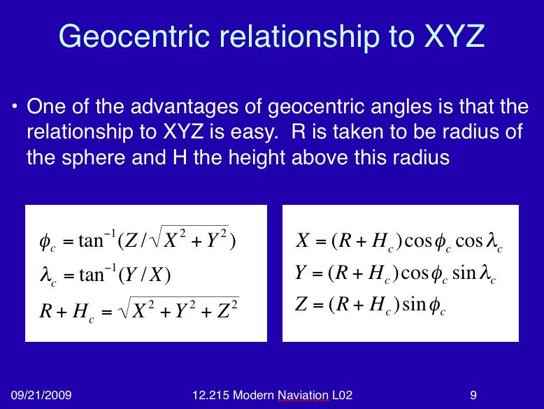
22 Geometry of the Sphere A sphere is a three-dimensional figure. We can determine coordinates of points with respect to a Cartesian [XYZ] system with origin at center.
23 Geocentric XYZ www-gpsg.mit.edu/~tah/12.215/ lec02.ppt - Excellent presentation by Thomas Herring of MIT
24
Lecture 4 Spherical Trigonometry and related topics. GISC January 2007
 Lecture 4 Spherical Trigonometry and related topics GISC-3325 24 January 2007 Another book recommendation By Bill Carter and Merri Sue Carter, Naval Institute Press, Annapolis, Maryland 2002 Review Latitude
Modern Navigation. Thomas Herring
 12.215 Modern Navigation Thomas Herring Today s Class Latitude and Longitude Simple spherical definitions Geodetic definition: For an ellipsoid Astronomical definition: Based on direction of gravity Relationships
Latitude and Longitude Pre Test
 Name Date Latitude and Longitude Pre Test Multiple Choice Directions: For questions, 1 10 circle the answer that letter that best answers the question. Each question is worth 1 point each. 1. To locate
Principles of Global Positioning Systems Spring 2008
 MIT OpenCourseWare http://ocw.mit.edu 12.540 Principles of Global Positioning Systems Spring 2008 For information about citing these materials or our Terms of Use, visit: http://ocw.mit.edu/terms. 12.540
Navigating by the Stars and Planets
 Navigating by the Stars and Planets (Finding your location from measured altitudes of celestial bodies) Presented to: Chagrin Valley Astronomical Society September 1, 2012 By Ron Baker, CVAS member Historical
Coordinate Systems. Location on earth is defined by coordinates
 Coordinate Systems We think of the earth as a sphere It is actually a spheroid (ellipsoid), slightly larger in radius at the equator than at the poles Shape of the Earth Location on earth is defined by
Principles of the Global Positioning System Lecture 04"
 12.540 Principles of the Global Positioning System Lecture 04" Prof. Thomas Herring" Room 54-820A; 253-5941" tah@mit.edu" http://geoweb.mit.edu/~tah/12.540 " Review" So far we have looked at measuring
Lesson 5: Map Scale and Projections
 Organizing Data and Information Lesson 5: Map Scale and Projections Map Scales Projections Information can be organized as lists, numbers, tables, text, pictures, maps, or indexes. Clusters of information
What is a Map Projection?
 What is a Map Projection? It is how we represent a three dimensional Earth on a flat piece of paper However The process of transferring information from the Earth to a map causes every projection to distort
ASTRONOMICAL NAVIGATION
 Basic terms ASTRONOMICAL NAVIGATION *astronomical navigation *compilation *astronomical tabels *celestial observations *solution of a sight * Sun/Moon/star sight *spherical trigonometry *PZX triangle *celestial
GIS in Water Resources. Fall Homework #1
 GIS in Water Resources Fall 2015 Homework #1 Goal The goal of this homework is to reinforce the lecture material on Geodesy, Map Projections and Coordinate Systems by having you identify attributes and
Tonight. {01} The map. Relative space. What does a map do? Types of maps GEOG 201 2/17/2010. Instructor: Pesses 1
 Tonight {01} The map What makes a map Measuring the Earth Map Interpretation & GPS Spring 2010 M. Pesses What does a map do? Shows where things are Shows spatial (topological) relationships Shows patterns,
CHAPTER 2 SKILL SHEET 2: CELESTIAL NAVIGATION
 CHAPTER 2 SKILL SHEET 2: CELESTIAL NAVIGATION Before the invention of GPS technology, how were people on ships far at sea, out of the sight of land, able to tell where they were? For thousands of years
Modern Navigation. Thomas Herring
 12.215 Modern Navigation Thomas Herring Review of last Class Review of linear Algebra. Class will be based on the book Linear Algebra, Geodesy, and GPS, G. Strang and K. Borre, Wellesley-Cambridge Press,
Map Projections. Displaying the earth on 2 dimensional maps
 Map Projections Displaying the earth on 2 dimensional maps Map projections Define the spatial relationship between locations on earth and their relative locations on a flat map Are mathematical expressions
Angles and Directions. Angles and Directions. CIVL 1112 Surveying - Azimuths and Bearings 1/8
 IVL 1112 Surveying - zimuths and earings 1/8 The most common relative directions are left, right, forward(s), backward(s), up, and down. x y z In planar geometry, an angle is the figure formed by two rays,
EARTHS SHAPE AND POLARIS PRACTICE 2017
 1. In the diagram below, letters A through D represent the locations of four observers on the Earth's surface. Each observer has the same mass. 3. Which diagram most accurately shows the cross-sectional
The Earth is a Rotating Sphere
 The Earth is a Rotating Sphere The Shape of the Earth Earth s Rotation ( and relative movement of the Sun and Moon) The Geographic Grid Map Projections Global Time The Earth s Revolution around the Sun
Outline. Shape of the Earth. Geographic Coordinates (φ, λ, z) Ellipsoid or Spheroid Rotate an ellipse around an axis. Ellipse.
 Ellipsoid or Spheroid Rotate an ellipse around an axis. Ellipse.") Map Projections Outline Geodesy and map projections Prof. D. Nagesh Kumar Department of Civil Engineering Indian Institute of Science Bangalore 560 012, India http://www.civil.iisc.ernet.in/~nagesh Shape
Map Projections Outline Geodesy and map projections Prof. D. Nagesh Kumar Department of Civil Engineering Indian Institute of Science Bangalore 560 012, India http://www.civil.iisc.ernet.in/~nagesh Shape
GIS in Water Resources Fall 2018 Homework #1
 GIS in Water Resources Fall 2018 Homework #1 Goal The goal of this homework is to reinforce the lecture material on Geodesy, Map Projections and Coordinate Systems by having you identify attributes and
Map projections. Rüdiger Gens
 Rüdiger Gens Coordinate systems Geographic coordinates f a: semi-major axis b: semi-minor axis Geographic latitude b Geodetic latitude a f: flattening = (a-b)/a Expresses as a fraction 1/f = about 300
EnvSci360 Computer and Analytical Cartography
 EnvSci360 Computer and Analytical Cartography Lecture 3 Geodesy Map Projections, Datums, and Coordinate Systems 1 Geodesy The science of measuring and representing the shape and size of the earth, and
WHERE ARE YOU? Maps & Geospatial Concepts Fall 2015
 WHERE ARE YOU? Maps & Geospatial Concepts Fall 2015 Where are you? Relative location I m at school Absolute Location 45 26 18.07 122 43 50.78 Where is Boston? Introducing Geodesy, Ellipsoids & Geoids Geodesy
Georeferencing, Map Projections, Cartographic Concepts. -Coordinate Systems -Datum
 Georeferencing, Map Projections, Cartographic Concepts -Map Projections -Coordinate Systems -Datum Map projection is "the process of systematically transforming positions on the Earth's spherical surface
SiRF White Paper. Great Circle Distances Computing the distance between two points on the surface of the Earth
 SiRF White Paper Great Circle Distances Computing the distance between two points on the surface of the Earth Carl Carter May 17, 2002 Introduction The distance between two points on the Earth is computed
WHERE ARE YOU? Maps & Geospatial Concepts Fall 2012
 WHERE ARE YOU? Maps & Geospatial Concepts Fall 2012 Where are you? Relative location I m at school Absolute Location 45 26 18.07 122 43 50.78 Datums Datums A reference surface of the Earth Used as the
Height systems. Rudi Gens Alaska Satellite Facility
 Rudi Gens Alaska Satellite Facility Outline Why bother about height systems? Relevant terms Coordinate systems Reference surfaces Geopotential number 2 Why bother about height systems? give a meaning to
What is Geodesy? Types of Geodesy terrestrial or classical geodesy space geodesy theoretical geodesy
 What is Geodesy? Geodesy is the study of: The size, shape and motion of the earth The measurement of the position and motion of points on the earth's surface, and The study of the earth's gravity field
Lecture Module 2: Spherical Geometry, Various Axes Systems
 1 Lecture Module 2: Spherical Geometry, Various Axes Systems Satellites in space need inertial frame of reference for attitude determination. In a true sense, all bodies in universe are in motion and inertial
GEOMATICS ENGINEERING / SURVEYING
 1 GEOMATICS ENGINEERING / SURVEYING CHAPTER 1 Dr. Muhammad Ashraf Javid Assistant Professor Department of Civil and Environmental Engineering Email: muhammad.javid@unizwa.edu.om 2 Geomatics Engineering
Georeferencing. Where on earth are we? Critical for importing and combining layers for mapping
 Georeferencing Where on earth are we? Critical for importing and combining layers for mapping 1. The Geoid Earth is not a perfect sphere, it is ellipsoidal.. earth is the 'Geoid'. The difference between
Lecture #03. January 20, 2010, Wednesday
 Lecture #03 January 20, 2010, Wednesday Causes of Earth s Seasons Earth-Sun geometry Day length Solar angle (beam spread) Atmospheric beam depletion Shape and Size of the Earth North Pole E Geoid: not
How do we describe a location on Earth? Geodetic reference system
 How do we describe a location on Earth? Geodetic reference system How do we define the shape of the earth? Definition of the sphere: A three-dimensional surface, all points of which are equidistant from
WHERE ARE YOU? LOCATING BY THE SUN
 WHERE ARE YOU? LOCATING BY THE SUN Sakari Ekko EAAE Summer School Working Group (Finland) Abstract In this workshop, we first find our location on the globe by the Sun and Polaris, the Pole Star. After
Lecture 4. Coordinate Systems & Projections
 Lecture 4 Coordinate Systems & Projections Outline Geodesy Geoids Ellipsoids Geographic Coordinate Systems Magnetic North vs. True North Datums Projections Applying Coordinate Systems and Projections Why
You can only use a planar surface so far, before the equidistance assumption creates large errors
 You can only use a planar surface so far, before the equidistance assumption creates large errors Distance error from Kiester to Warroad is greater than two football fields in length So we assume a spherical
The Wildlife Society Meet and Greet. Come learn about what the UNBC Student Chapter of TWS is all about!
 Georeferencing I GEOG 300, Lecture 4 Dr. Anthony Jjumba 1 The Wildlife Society Meet and Greet Quiz Come learn about what the UNBC Student Chapter of TWS is all about! 5:30 7:30 PM, Wednesday September
Shape e o f f the e Earth
 1 Coordinate Systems & Projections Coordinate Systems Two map layers are not going to register spatially unless they are based on the same coordinate system. 2 Contents Shape of the earth Datum Projections
Lecture 10-14: Map Projections and Coordinate System
 URP 1281 Surveying and Cartography Lecture 10-14: Map Projections and Coordinate System December 27, 2015 Course Teacher: Md. Esraz-Ul-Zannat Assistant Professor Department of Urban and Regional Planning
Coordinates on the Sphere
 Survey Observations Coordinates on the Sphere Any position on the surface of a sphere (such as the Earth or the night sky) can be expressed in terms of the angular coordinates latitude and longitude Latitude
Lecture 2. Map Projections and GIS Coordinate Systems. Tomislav Sapic GIS Technologist Faculty of Natural Resources Management Lakehead University
 Lecture 2 Map Projections and GIS Coordinate Systems Tomislav Sapic GIS Technologist Faculty of Natural Resources Management Lakehead University Map Projections Map projections are mathematical formulas
Exercise 1.0 THE CELESTIAL EQUATORIAL COORDINATE SYSTEM
 Exercise 1.0 THE CELESTIAL EQUATORIAL COORDINATE SYSTEM Equipment needed: A celestial globe showing positions of bright stars and Messier Objects. I. Introduction There are several different ways of representing
MEASURING THE SIZE OF THE EARTH - WebAssign
 Name: Book: Period: Due Date: Lab Partners: MEASURING THE SIZE OF THE EARTH - WebAssign Purpose: Use Eratosthenes' method to determine the circumference of the Earth. Familiarize yourself with angular
Mapping coordinate systems
 Mapping coordinate systems 1. The Earth's Graticule Latitude and Longitude The graticule is the imaginary grid of lines running east-west (lines of latitude = parallels) and north-south lines of longitude
This week s topics. Week 6. FE 257. GIS and Forest Engineering Applications. Week 6
 FE 257. GIS and Forest Engineering Applications Week 6 Week 6 Last week Chapter 8 Combining and splitting landscape features and merging GIS databases Chapter 11 Overlay processes Questions? Next week
Cartesian Coordinates Need two dimensional system 2 number lines perpendicular to each other X-axis is horizontal Y-axis is vertical Position relative
 General Physical Science Chapter 15 Place and Time Space and Time Einstein Space and time related Single entity Time is the 4 th dimension! Cartesian Coordinates Need some system to tell us where something
Height systems. Rüdiger Gens
 Rüdiger Gens 2 Outline! Why bother about height systems?! Relevant terms! Coordinate systems! Reference surfaces! Geopotential number! Why bother about height systems?! give a meaning to a value defined
Geographic coordinate systems
 1 Geographic coordinate systems In this chapter you ll learn about longitude and latitude. You ll also learn about the parts that comprise a geographic coordinate system including Spheres and spheroids
Geog Lecture 29 Mapping and GIS Continued
 Geog 1000 - Lecture 29 Mapping and GIS Continued http://scholar.ulethbridge.ca/chasmer/classes/ Today s Lecture (Pgs 13-25, 28-29) 1. Hand back Assignment 3 2. Review of Dr. Peddle s lecture last week
1. Which graph best represents the altitude of Polaris observed at northern latitude positions on the Earth's surface?
 1. Which graph best represents the altitude of Polaris observed at northern latitude positions on the Earth's surface? A) 4. The diagram below shows an observer measuring the altitude of Polaris. B) C)
1. Geospatial technology rarely links geospatial data to nonspatial data. a. True *b. False
 Chapter 2 Where in the Geospatial World Are You? 1. Geospatial technology rarely links geospatial data to nonspatial data. 2. For geospatial technology to work, every location on Earth must be: a. inhabited
Modern Navigation. Thomas Herring
 12.215 Modern Navigation Thomas Herring Today s class Map Projections: Why projections are needed Types of map projections Classification by type of projection Classification by characteristics of projection
Mid Term Prep-Shape of the Earth
 1. The Earth is slightly flattened from a perfect spherical shape because of A) its rotation B) the pull of the sun and moon C) storms on the sun's surface D) its molten core 2. The diagrams below represent
Geographers Perspectives on the World
 What is Geography? Geography is not just about city and country names Geography is not just about population and growth Geography is not just about rivers and mountains Geography is a broad field that
The time they chose was the Vernal Equinox of March 20, 2000, at 7:30 AM Greenwich Mean Time (GMT). Right Ascension Offset
. Right Ascension Offset") Star Coordinates and the Celestial Dome Astronomers have mapped out the sky in the shape of a spherical dome the Celestial Sphere, where earth is just a tiny spec at the center of the dome. The celestial
Star Coordinates and the Celestial Dome Astronomers have mapped out the sky in the shape of a spherical dome the Celestial Sphere, where earth is just a tiny spec at the center of the dome. The celestial
Energy Efficiency, Acoustics & Daylighting in building Prof. B. Bhattacharjee Department of Civil Engineering Indian Institute of Technology, Delhi
 Energy Efficiency, Acoustics & Daylighting in building Prof. B. Bhattacharjee Department of Civil Engineering Indian Institute of Technology, Delhi Lecture - 05 Introduction & Environmental Factors (contd.)
+ 35º 53ʹ 16ʺ 84º 09ʹ 35ʺ
 + 35º 53ʹ 16ʺ 84º 09ʹ 35ʺ 35º 53ʹ 16ʺ N 84º 09ʹ 35ʺ W (the precise location of Farragut High School!) Spherical Coordinates Mapping a Sphere The student will be able to: HW: 1 Utilize and convert SI units
1. For Cosine Rule of any triangle ABC, b² is equal to A. a² - c² 4bc cos A B. a² + c² - 2ac cos B C. a² - c² + 2ab cos A D. a³ + c³ - 3ab cos A
 1. For Cosine Rule of any triangle ABC, b² is equal to A. a² - c² 4bc cos A B. a² + c² - 2ac cos B C. a² - c² + 2ab cos A D. a³ + c³ - 3ab cos A 2. For Cosine Rule of any triangle ABC, c² is equal to A.
PHYSICAL GEOGRAPHY. By Brett Lucas
 PHYSICAL GEOGRAPHY By Brett Lucas INTRODUCTION Introduction to Earth Geography as a Field of Learning Geography is from two Greek words, Geo Earth, and Graphien to write. Elements/Branches of Geography
Practice Questions: Shape of the Earth
 Practice Questions: Shape of the Earth 1. The Earth is slightly flattened from a perfect spherical shape because of A) its rotation B) the pull of the sun and moon C) storms on the sun's surface D) its
1. Write down the term 2. Write down the book definition 3. Put the definition in your own words 4. Draw an image and/or put a Real Life Example
 Unit 1 Vocabulary 1. Write down the term 2. Write down the book definition 3. Put the definition in your own words 4. Draw an image and/or put a Real Life Example Absolute Location Where Is It EXACTLY?
12/26/2012. Geographic Information Systems * * * * GIS (... yrezaei
 ( - Geographic Information Systems ( ( 1 2 3 Information System Data base DB IS IS DB (Knowledge ( ( (System (Information System - (Georefrence Analysis Data + Knowledge ======== Information 4 5 ( < 10%
A) greatest in diameter at the Equator B) 44 05' N 73 55' W B) Albany D) Polaris B) 8 h
 greatest in diameter at the Equator B) 44 05' N 73 55' W B) Albany D) Polaris B) 8 h") 1. Measurements taken from space show the Earth to be A) greatest in diameter at the Equator B) greatest in diameter at the poles C) a perfect sphere D) pear shaped 2. New York State's highest peak, Mt.
1. Measurements taken from space show the Earth to be A) greatest in diameter at the Equator B) greatest in diameter at the poles C) a perfect sphere D) pear shaped 2. New York State's highest peak, Mt.
Homework. In GIS Fundamentals book, Chapter 2, exact formula
 Homework In GIS Fundamentals book, Chapter 2, exact formula Homework 2) Use the spherical triangles method to calculate the ini7al azimuth from St. Paul to: Reykjavik t r o N e l o hp C a B Reykjavik
Plane coordinates ~~~~~~~~~~
 Coordinate Systems & Map Projections Geographic coordinates A Basic Introduction to Coordinate Systems & Map Projections Latitude & longitude Angles Parallels & meridians Lines Plane coordinates ~~~~~~~~~~
MTH 133: Plane Trigonometry
 MTH 133: Plane Trigonometry Radian Measure, Arc Length, and Area Angular and Linear Velocity Thomas W. Judson Department of Mathematics & Statistics Stephen F. Austin State University Fall 2017 Plane Trigonometry
REFERENCING COORDINATE SYSTEMS MAP PROJECTIONS GEOREFERENCING
 GIS in Ecology SPATIAL REFERENCING COORDINATE SYSTEMS MAP PROJECTIONS GEOREFERENCING : :1 Where on earth? Early mapmakers recognized the need for a system that could locate features on the earth's surface.
Modern Navigation
 12.215 Modern Navigation Thomas Herring (tah@mit.edu), MW 10:30-12:00 Room 54-322 http://geoweb.mit.edu/~tah/12.215 Course Overview The development of the Global Positioning System (GPS) started in the
Shape of Earth, Cycles, Distribution of Water
 Shape of Earth, Cycles, Distribution of Water What is the shape of Earth? A. Spherical B. Apple-shaped C. Pear-shaped Shape of the Earth It should be spherical: Earth condensed under gravity, thus everything
Shape of Earth, Cycles, Distribution of Water
 Shape of Earth, Cycles, Distribution of Water What is the shape of Earth? A. Spherical B. Apple-shaped C. Pear-shaped Shape of the Earth It should be spherical: Earth condensed under gravity, thus everything
Intro to GIS Fall 2010 Georeferencing & Map Projections
 Intro to GIS Fall 2010 Georeferencing & Map Projections SHAPE OF THE EARTH Earth's Shape Geoid: shape of earth minus topographic features (irregular due to local variations in gravity) Ellipsoid: elongated
Key Issue #1. How do geographers describe where things are? 2014 Pearson Education, Inc.
 Key Issue #1 How do geographers describe where things are? Learning Outcomes 1.1.1: Explain differences between early maps and contemporary maps. 1.1.2: Describe the role of map scale and projections and
Ex. 2: La)tude, Longitude, Spherical Distance
tude, Longitude, Spherical Distance") Ex. 2: La)tude, Longitude, Spherical Distance Geographic Coordinates, Spherical Distance Geographic coordinates are any of a variety of systems that establishing absolute positions on the surface of the
Ex. 2: La)tude, Longitude, Spherical Distance Geographic Coordinates, Spherical Distance Geographic coordinates are any of a variety of systems that establishing absolute positions on the surface of the
What is the shape of Earth?
 Shape of Earth, Cycles, Distribution of Water 1 What is the shape of Earth? A. Spherical B. Apple-shaped C. Pear-shaped 2 Draw shape of the Earth 3 1 Shape of the Earth It should be spherical: Earth condensed
Georeferencing. Place names Postal addresses Postal codes Coordinate systems (lat/long, UTM, etc.)
") Georeferencing Georeferencing Used to describe the act of assigning locations to data or information Certain requirements include that they are: unique, have shared meaning, and are persistent through
Georeferencing Georeferencing Used to describe the act of assigning locations to data or information Certain requirements include that they are: unique, have shared meaning, and are persistent through
Latitude and Longitude
 Latitude and Longitude Finding Your Location on a Sphere Coordinate Systems n When you are locating a point on a flat surface you can use Cartesian coordinates of x and y. n The point 2, 3 is plotted on
Observing the Night Sky: Locating Objects
 Observing the Night Sky: Locating Objects As I left the house this morning, there was a bright bluish light above and to the left of my neighbors house (approximately East) and a big very bright object
Central Angles and Arcs
 Advance Algebra & Trigonometry Angles & Circular Functions Central Angles and Arcs Arc Length 1. A central angle an angle whose vertex lies at the center of the circle: A B ABC is a central angle C 2.
Chapter 3 Geographic Location Systems
 Chapter 3 Geographic Location Systems In this chapter you will learn about: Latitude and longitude Universal Transverse Mercator (UTM) U.S. Public Land Survey Other geographic location systems Geographic
Geographic Grid -Latitudes and Longitudes
 GEOGRAPHY STD 9 Geographic Grid -Latitudes and Longitudes 2018-2019 Q1. Define Geographic Grid. The network of latitudes and longitudes are known as Geographic Grid. They help us to locate places on the
Surveying Prof. Bharat Lohani Department of Civil Engineering Indian Institute of Technology, Kanpur
 Surveying Prof. Bharat Lohani Department of Civil Engineering Indian Institute of Technology, Kanpur Module - 12 Lecture - 1 Global Positioning System (Refer Slide Time: 00:20) Welcome to this video lecture
4. Which object best represents a true scale model of the shape of the Earth? A) a Ping-Pong ball B) a football C) an egg D) a pear
 a Ping-Pong ball B) a football C) an egg D) a pear") Name Test on Friday 1. Which diagram most accurately shows the cross-sectional shape of the Earth? A) B) C) D) Date Review Sheet 4. Which object best represents a true scale model of the shape of the Earth?
Name Test on Friday 1. Which diagram most accurately shows the cross-sectional shape of the Earth? A) B) C) D) Date Review Sheet 4. Which object best represents a true scale model of the shape of the Earth?
Dr. ABOLGHASEM AKBARI Faculty of Civil Engineering & Earth Resources, University Malaysia Pahang (UMP)
") Workshop on : Dr. ABOLGHASEM AKBARI Faculty of Civil Engineering & Earth Resources, University Malaysia Pahang (UMP) 14-15 April 2016 Venue: Tehran, Iran GIS definitions GIS: A simplified view of the real
Workshop on : Dr. ABOLGHASEM AKBARI Faculty of Civil Engineering & Earth Resources, University Malaysia Pahang (UMP) 14-15 April 2016 Venue: Tehran, Iran GIS definitions GIS: A simplified view of the real
A GLOBAL POSITIONING SYSTEM (GPS) PRIMER. Robert Augustson. B.A. Regents College, A thesis submitted to the. University of Colorado at Denver
 PRIMER. Robert Augustson. B.A. Regents College, A thesis submitted to the. University of Colorado at Denver") A GLOBAL POSITIONING SYSTEM (GPS) PRIMER by Robert Augustson B.A. Regents College, 2000 A thesis submitted to the University of Colorado at Denver in partial fulfillment of the requirements for the degree
A GLOBAL POSITIONING SYSTEM (GPS) PRIMER by Robert Augustson B.A. Regents College, 2000 A thesis submitted to the University of Colorado at Denver in partial fulfillment of the requirements for the degree
Workshop on GNSS Data Application to Low Latitude Ionospheric Research May Fundamentals of Satellite Navigation
 2458-6 Workshop on GNSS Data Application to Low Latitude Ionospheric Research 6-17 May 2013 Fundamentals of Satellite Navigation HEGARTY Christopher The MITRE Corporation 202 Burlington Rd. / Rte 62 Bedford
Earth s Time Zones. Time Zones In The United States
 Name: Mr. DeLeo Date: Period: Earth s Time Zones Goal: Students will understand why humans have developed time zones on Earth, and how to figure out time at different positions on Earth. Background: One
Fundamentals of Satellite technology
 Fundamentals of Satellite technology Prepared by A.Kaviyarasu Assistant Professor Department of Aerospace Engineering Madras Institute Of Technology Chromepet, Chennai Orbital Plane All of the planets,
Spherical Geometry HSC. Name:
 Spherical Geometry HSC Name: C:\Documents and Settings\tracey_h-butters\Desktop\mathematics\year_levels\math_stage6\General\hsc\spherical_geometry\spherical_geo_notes.doc 1 HSC CAPACITY MATRIX GENERAL
Satellite Communications
 Satellite Communications Lecture (3) Chapter 2.1 1 Gravitational Force Newton s 2nd Law: r r F = m a Newton s Law Of Universal Gravitation (assuming point masses or spheres): Putting these together: r
Time and Diurnal Motion. 1a. The Earth Is Flat. 1c. Aristotle ( BC) 1b. The Earth Is Round. Time and Diurnal Motion
 1b. The Earth Is Round. Time and Diurnal Motion") Time and Diurnal Motion Time and Diurnal Motion A. Geography: mapping the earth 2 B. Equatorial Coordinates C. Local Horizon System Updated April 12, 2006 A. Geography: mapping the earth Geometry: measure
Time and Diurnal Motion Time and Diurnal Motion A. Geography: mapping the earth 2 B. Equatorial Coordinates C. Local Horizon System Updated April 12, 2006 A. Geography: mapping the earth Geometry: measure
Welcome to Lesson 4. It is important for a GIS analyst to have a thorough understanding of map projections and coordinate systems.
 Welcome to Lesson 4. It is important for a GIS analyst to have a thorough understanding of map projections and coordinate systems. A GIS without coordinates would simply be a database like Microsoft Excel
NUMB3RS Activity: Traveling on Good Circles Episode: Spree, Part I
 Teacher Page 1 NUMB3RS Activity: Traveling on Good Circles Episode: Spree, Part I Topic: Geodesics on a sphere Grade Level: 11-1 Objective: Find the shortest great circle distance between two cities. Time:
GEOGRAPHIC COORDINATE SYSTEMS
 GEOGRAPHIC COORDINATE SYSTEMS Introduction to GIS Winter 2015 What is Georeferencing? Used to establish a location on the Earth s surface 1 st order polynomial transformation Georeferencing toolbar What
VT State Plane. Daniel J. Martin National Geodetic Survey VT Geodetic Advisor. VSLS Conference Rutland VT April 11, 2008
 VT State Plane Daniel J. Martin National Geodetic Survey VT Geodetic Advisor VSLS Conference Rutland VT April 11, 2008 Today s Outline Define the problem Review of VT State Plane System Relationship
ASTRONOMICAL COORDINATE SYSTEMS CELESTIAL SPHERE
 ASTRONOMICAL COORDINATE SYSTEMS CELESTIAL SPHERE To the naked eye, stars appear fixed on the sky with respect to one another. These patterns are often grouped into constellations. Angular measurements
Importance of Understanding Coordinate Systems and Map Projections.
 Importance of Understanding Coordinate Systems and Map Projections. 1 It is extremely important that you gain an understanding of coordinate systems and map projections. GIS works with spatial data, and,
Understanding Projections for GIS
 Presented by John Schaeffer Juniper GIS Services, Inc. This PowerPoint is available at JuniperGIS.com Presentation Objectives To understand basic concepts on projections and coordinate systems for the
Vectors and Geometry
 Vectors and Geometry Vectors In the context of geometry, a vector is a triplet of real numbers. In applications to a generalized parameters space, such as the space of random variables in a reliability
Chapter 3 Models of the Earth. 3.1 Finding Locations on the Earth. 3.1 Objectives
 Chapter 3 Models of the Earth 3.1 Finding Locations on the Earth 3.1 Objectives Explain latitude and longitude. How can latitude and longitude be used to find locations on Earth? How can a magnetic compass
EARTH SCIENCE KEY UNIT 2-H
 EARTH SCIENCE KEY UNIT 2-H UNIT 2 MODELS & DIMENSIONS OF EARTH I. Model = ANYTHING THAT REPRESENTS THE PROPERTIES OF AN OBJECT OR SYSTEM A. Types and examples of models: 1. PHYSICAL Provides us with information