Spherical Geometry HSC. Name:
|
|
|
- Leon Justin Bailey
- 6 years ago
- Views:
Transcription

1 Spherical Geometry HSC Name: C:\Documents and Settings\tracey_h-butters\Desktop\mathematics\year_levels\math_stage6\General\hsc\spherical_geometry\spherical_geo_notes.doc 1
2 HSC CAPACITY MATRIX GENERAL MATHEMATICS TOPIC: Measurement 7 - Spherical Geometry 2 weeks CONTENT CAPACITY BREAKDOWN! DONE IT!!!! GOT IT!!!!! ON MY WAY! WORKING ON IT! HELP!!!! 1. Calculating arc lengths of circles Ex 13A Q1a, c, e, 2, 3a, c, e, 4-7, 8a, c, e, Distinguishing between great and small circles Ex 13B 3. Using the Equator and the Greenwich Meridian as lines of reference for locations on the Earth s surface 4. Locating positions on the globe using latitude and longitude 5. Converting nautical miles to kilometres and vice versa 6. Calculating distances between 2 points on the same great circle in nautical miles and km 7. Defining 1 knot as a speed of 1nM per hour 8. Using time zones and the International Date line in solving problems 9. Calculating time differences given the difference in longitudes 10. Determining times for cities in different countries in related travel questions Ex 13C Ex 13D Credit card research task Ex 13E Where in the World are the Simpsons? task Your say! What was the most important thing you learned? What was something new you learnt? What part(s) of this topic will you need to work on? C:\Documents and Settings\tracey_h-butters\Desktop\mathematics\year_levels\math_stage6\General\hsc\spherical_geometry\spherical_geo_notes.doc 2
3 ARC LENGTH θ arc An arc is part of the circumference of a circle A major arc is more than half of the circumference and a minor arc is less than half of the circumference. The length l, of an arc in a circle with radius r can be found using: l = θ πr where θ is the angle subtended by the arc at the centre of the circle. eg The radius of the Earth is approximately km. a) Calculate the circumference of the Earth at the equator, correct to the nearest kilometre. b) Two points of the equator subtend at a 15 angle at the centre of the Earth. Calculate the distance between them, correct to the nearest kilometre; c) The distance between two points on the Equator is km. What is the angular distance between the points? 3
4 Application of Arc Length You are to determine the approximate starting positions for a standard shaped 400m running track which is composed of two congruent straight-aways and two congruent circles as shown below. The width of a lane is 1.2m. 4
 slicing through an orange (a sphere) the result is a circle] A great circle is formed when a plane cuts the surface of a sphere and passes through its centre.")
5 GREAT AND SMALL CIRCLES The intersection of a plane and a sphere is a circle. [Think about a knife (a plane) slicing through an orange (a sphere) the result is a circle] A great circle is formed when a plane cuts the surface of a sphere and passes through its centre. A small circle is formed when a plane cuts the surface of a sphere and does not pass through its centre. Some of the important features of Earth are shown in the following diagram: Antipodal points are the endpoints of a diameter of a great circle. N, S and W, E are two pairs of antipodal points. NOS is the axis of Earth. N and S are called the poles. The great circle WE is the Equator. The angle between two great circles is the angle between their planes. The length of a great circle can be calculated by C = 2 π r ORC = πd To calculate the length around a small circle, the radius of the small circle must be known. eg Calculate the length of a great circle on a sphere with a radius of 55cm. Give your answer correct to the nearest centimetre. eg Calculate the length of the small circle from the diagram, correct to 1 decimal place. 5
6 LATITUDE & LONGITUDE Parallels of Latitude are small circles that are parallel to the Equator, latitude 0. They are marked off in degrees from the equator so latitude is the angular distance of a point NORTH or SOUTH of the equator. Meridians of Longitude are great circles that pass through the north and south poles. Longitude is measured in degrees EAST of WEST of the Greenwich meridian, longitude 0 (which runs through Greenwich, a suburb of London England) The meridian of longitude opposite Greenwich is the International Date Line. It has longitude 180 either east or west. On either side of the International Date Line the day changes. For this reason, the International Date Line does not pass through any land mass. The position of any point on the surface of the Earth can be specified by using latitude and longitude, in that order! The 2 values are written as an ordered pair, eg the coordinates of Sydney are 30 S, 150 E. The nautical mile (n mile) is equal to km and is used in navigation to measure the distance travelled on the surface of the Earth. It is defined as the length of an arc of a great circle subtended by 1 (1 minute: 60 minutes = 1 ) 6
 Which point is at (30 N, 55 E) and which point is a (0, 55 E)?")
 30 N, 120 E (iii) 45 N, 75 W d) Select three cities from the map that you would like to visit and")
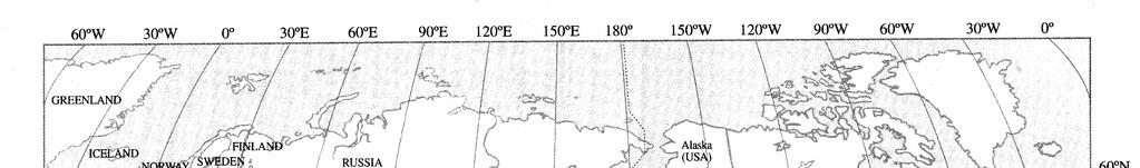
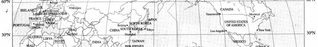
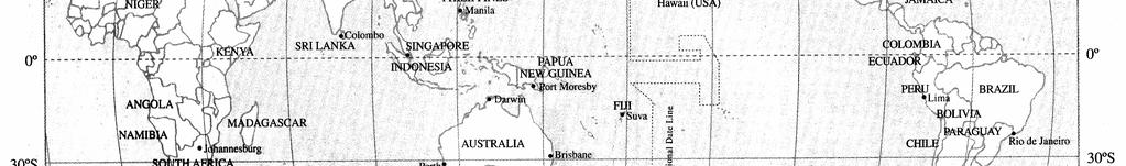
7 eg From the given diagram: a) Give the locations of points P, Q, T and L using latitude and longitude. b) Which point is at (30 N, 55 E) and which point is a (0, 55 E)? c) Using the map overleaf, identify the major cities closest to the following locations: (i) 30 S, 30 E (ii) 30 N, 120 E (iii) 45 N, 75 W d) Select three cities from the map that you would like to visit and write the name and coordinates: (i) (ii) (iii) 7
8 8
9 DISTANCES ON THE EARTH S SURFACE POINTS TO CONSIDER: The angular distance between 2 points on the same meridian of longitude or the equator can be found by: S SUBTRACTING the latitudes if the points are on the SAME side of the equator; S ADDING the latitudes if the points are on opposite sides of the equator. An angular distance can be converted to a distance using 1 = 60 nm The distance between 2 points on the same great circle can also be found using the arc length formula. Speed can be measured in knots. A speed of 1 knot = 1nm/h The distance along a small circle can be found by r = R cosα where r is the radius of small circle R is the radius of great circle α is the latitude of the small circle eg A great circle arc CD makes an angle of 85 at the centre of the Earth. a) Find the spherical distance CD in nautical miles. b) Calculate the distance between points B and D in nautical miles. C:\Documents and Settings\tracey_hbutters\Desktop\mathematics\year_levels\math_stage6\General\hsc\spherical_geometry\spherical_geo_notes.doc 9

10 eg Find the distance between the point A 60 N, 50 E and the point B 60 N, 170 E to the nearest kilometre. 1. Draw a 3D picture; 2. Calculate the radius of the small circle; 3. Calculate the arc length 4. State the answer C:\Documents and Settings\tracey_hbutters\Desktop\mathematics\year_levels\math_stage6\General\hsc\spherical_geometry\spherical_geo_notes.doc 10
 Calculate the average speed of the ship, in knots, if the journey took 77 hours. eg A ship travels from 120 E to 135 40 E along the Equator. a) Calculate the distance travelled in nautical miles.")
11 eg A ship travels through an arc of 22 around the 30 S parallel of latitude. a) Calculate the distance travelled, correct to the nearest nautical mile. b) Calculate the average speed of the ship, in knots, if the journey took 77 hours. eg A ship travels from 120 E to E along the Equator. a) Calculate the distance travelled in nautical miles. b) Calculate the time taken for the ship to sail between these two points at an average speed of 50 knots. C:\Documents and Settings\tracey_hbutters\Desktop\mathematics\year_levels\math_stage6\General\hsc\spherical_geometry\spherical_geo_notes.doc 11
12 TIME ZONES & STANDARD TIMES AUSTRALIAN TIME ZONES Australia is divided into 3 time zones: S S S S Eastern Standard Time NSW, Queensland, Victoria, Tasmania Central Standard Time (-0.5h) NT, South Australia Western Standard Time (-2 h) Western Australia If a state has Daylight saving, then ONE HOUR has been added (so to calculate the time against it, subtract 1 hour) eg Merimbula is GMT +10 while New York is GMT -5. a) Calculate the time difference between Merimbula and New York; b) We currently have daylight saving, so if it is Tuesday 11:00 am in Merimbula, what is the actual time in New York; eg Adelaide is GMT +9.5 while Athens is GMT +1. When it is 11:00am in Athens, what is the time in Adelaide? TIME CONVERSIONS The time calculated by the longitude is called standard time. Time zones are calculated to approximate all the standard times in a region. As there are 24 hours in a day and 360 of longitude, we can calculate that: 1 hour = of longitude; 1 = minutes S When we move EAST across the IDL we put the date back one day; S When we move WEST across the IDL we add a day; C:\Documents and Settings\tracey_hbutters\Desktop\mathematics\year_levels\math_stage6\General\hsc\spherical_geometry\spherical_geo_notes.doc 12
13 S Dividing the degrees by 15 gives the number of hours difference; eg Great Aunt Edna wants to watch the Ashes series but she is currently holidaying in London. If the match begins on Thursday, 10:00am in Brisbane 150 E, what time will Edna need to turn on the TV? eg In Los Angeles 120 W a tennis match was held at 9:00pm on Tuesday. This match was televised live in Sydney. On what day and what time (Eastern Standard time) was the match shown on Sydney television? eg A (50 S, 20 W) and B (50 S, 60 W) are two points on Earth s surface. The radius of Earth is approximately 6400 km. a) Neatly sketch the above information; b) Calculate the local time at A if it is 9:00am in B. c) Calculate the radius of the parallel of latitude 50 S to the nearest kilometre. d) Calculate the shortest distance between A and B along the parallel of latitude 50 S. C:\Documents and Settings\tracey_hbutters\Desktop\mathematics\year_levels\math_stage6\General\hsc\spherical_geometry\spherical_geo_notes.doc 13

14 WHERE IN THE WORLD ARE THE SIMPSONS!!! aassddffgghhkk Web sites to use: World Time Differences World Atlas site TASK: The Simpsons have gone on a trip to Australia. As always, the family do not follow instructions and now Marge has lost them all. Thankfully everyone has a mobile phone so she can contact them. To try and organise the mess, Marge has decided to create a chart so she knows when to ring everyone. It is very important that both 12 hour time and 24 hour time is given, plus the day. Also Marge has decided to mark on a world map where each person (and dog) are for reference. You have offered to help Marge out and complete the chart and map. yyuuoobbnnmm C:\Documents and Settings\tracey_hbutters\Desktop\mathematics\year_levels\math_stage6\General\hsc\spherical_geometry\spherical_geo_notes.doc 14
15 C:\Documents and Settings\tracey_h-butters\Desktop\mathematics\year_levels\math_stage6\General\hsc\spherical_geometry\spherical_geo_notes.doc 15
16 C:\Documents and Settings\tracey_h-butters\Desktop\mathematics\year_levels\math_stage6\General\hsc\spherical_geometry\spherical_geo_notes.doc 16
LATITUDES AND LONGITUDES
 NAME SCHOOL INDEX NUMBER DATE LATITUDES AND LONGITUDES KCSE 1989 2012 Form 4 Mathematics Answer all the questions 1. 1989 Q18 P1 A globe representing the earth has a radius 0.5m. Points A(10 0 W), B (0
Earth geometry. Strand: Applied geometry. Core topic: Elements of applied geometry
 Earth geometry 6 syllabusref Strand: Applied geometry eferenceence Core topic: Elements of applied geometry In this cha chapter 6A Latitude and longitude 6B Distances on the Earth s surface 6C Time zones
Time Zones. Doug Fischer Geog 106 LRS
 Time Zones Doug Fischer Geog 106 LRS Learning goals Students should be able to Explain time zones as a function of longitude Calculate time differences between different locations Demonstrate corrections
THE EARTH AND ITS REPRESENTATION
 UNIT 7 THE EARTH AND ITS REPRESENTATION TABLE OF CONTENTS 1 THE EARTH AND THE SOLAR SYSTEM... 2 2 THE EARTH S MOVEMENTS... 2 2.1 Rotation.... 2 2.2 The revolution of the Earth: seasons of the year....
Cartesian Coordinates Need two dimensional system 2 number lines perpendicular to each other X-axis is horizontal Y-axis is vertical Position relative
 General Physical Science Chapter 15 Place and Time Space and Time Einstein Space and time related Single entity Time is the 4 th dimension! Cartesian Coordinates Need some system to tell us where something
Latitudes and Longitudes
 Latitudes and Longitudes Angles are used to label latitudes and longitudes in order to locate points on our planet. It is a known fact that the earth is approximately a big sphere with a radius that is
ASTRONOMICAL NAVIGATION
 Basic terms ASTRONOMICAL NAVIGATION *astronomical navigation *compilation *astronomical tabels *celestial observations *solution of a sight * Sun/Moon/star sight *spherical trigonometry *PZX triangle *celestial
GEOGRAPHY STD.9 LATITUDE & LONGITUDE
 GEOGRAPHY STD.9 LATITUDE & LONGITUDE 1. What is the Earth Grid? A. The complete network of meridians & parallels is called the earth Grid. 2. What is Latitude? A. The latitude of a place is the distance
NUMB3RS Activity: Traveling on Good Circles Episode: Spree, Part I
 Teacher Page 1 NUMB3RS Activity: Traveling on Good Circles Episode: Spree, Part I Topic: Geodesics on a sphere Grade Level: 11-1 Objective: Find the shortest great circle distance between two cities. Time:
Geographic Grid -Latitudes and Longitudes
 GEOGRAPHY STD 9 Geographic Grid -Latitudes and Longitudes 2018-2019 Q1. Define Geographic Grid. The network of latitudes and longitudes are known as Geographic Grid. They help us to locate places on the
Background Information
 Oceanography LAB #1: Marine Charts and Navigation Background Information Latitude and Longitude A coordinate is an address a means of designating location. Most coordinate systems involve a network of
Geographic Grid. Locations Feature 1 Feature 2 Feature 3
 Geographic Grid Name The geographic grid refers to the internationally-recognized system of latitude and longitude used to location positions on Earth's surface. Accurate use of this coordinate system
2 Mapping Earth Reading Essentials. 2. Contrast What is the difference between a map view and a profile view?
 Mapping Earth Maps What do you think? Read the three statements below and decide whether you agree or disagree with them. Place an A in the Before column if you agree with the statement or a D if you disagree.
World Time-Day Calculator Lab
 Background: Time zones around the Earth are bounded by imaginary lines called lines of longitude, or meridians. On a globe or map of the world, they are the lines that are perpendicular to the equator.
LAB C - GEOGRAPHIC GRID AND TIME
 Introduction LAB C - GEOGRAPHIC GRID AND TIME In this lab the student will learn to determine latitude and longitude, to plot the location of various places on a geographic grid, and to calculate the difference
Why does Earth rotate and what s the evidence? (besides watching it from space ships or satellites) Week 18 January 5, 2015
 Week 18 January 5, 2015") Why does Earth rotate and what s the evidence? (besides watching it from space ships or satellites) Week 18 January 5, 2015 The sun determines our solar time everywhere on earth as Earth rotates. Can you
Why does Earth rotate and what s the evidence? (besides watching it from space ships or satellites) Week 18 January 5, 2015 The sun determines our solar time everywhere on earth as Earth rotates. Can you
1. Label a few examples of lines of latitude and lines of longitude on the globe above left.
 Oceanography 2 Location, Direction, and Distance on Nautical Charts Please read Appendix III in the textbook for reference. Learning Objectives for the first nautical chart Lab 1. Use the latitude-longitude
Cartography the art of making maps
 Cartography the art of making maps A map is a drawing or a picture of the earths surface, showing how things are related to each other by distance, direction and size. Maps are used for: Navigation Distance
Lesson 20: The Earth in its Orbit
 291 Lesson 20: The Earth in its Orbit Recall that the Earth s orbit around the un is an ellipse which is almost a perfect circle. The average distance from the un to the Earth is 152,100,000 km (to the
CHAPTER 24 THE SAILINGS
 CHAPTER 24 THE SAILINGS INTRODUCTION 2400. Introduction Dead reckoning involves the determination of one s present or future position by projecting the ship s course and distance run from a known position.
FIND PLACES ON GLOBES USING LATITUDE
 GLOBES, MAPS & GRAPHS FIND PLACES ON GLOBES USING LATITUDE AND LONGITUDE LINES FIND PLACES ON MAPS USING A GRID SYSTEM NAME SEVERAL TYPES OF MAP PROJECTIONS AND EXPLAIN THEIR BENEFITS AND SHORTCOMINGS
LONGITUDE AND LATITUDE. Semi great circles joining the true or geographic poles of the earth (true meridians).
.") MERIDIANS OF LONGITUDE LONGITUDE AND LATITUDE Semi great circles joining the true or geographic poles of the earth (true meridians). They are measured from 0 to 180 degrees East and West of the PRIME MERIDIAN,
MERIDIANS OF LONGITUDE LONGITUDE AND LATITUDE Semi great circles joining the true or geographic poles of the earth (true meridians). They are measured from 0 to 180 degrees East and West of the PRIME MERIDIAN,
Data Analysis 4. Summary Stats. General Maths - Preliminary. Name:
 Data Analysis 4 Summary Stats General Maths - Preliminary Name: C:\Documents and Settings\tracey_hbutters\Desktop\mathematics\year_levels\math_stage6\General\preliminary\notes\statistics\data4\data_ana
Geographers Tools: Location Systems Prof. Anthony Grande Hunter College Geography
 5 Geographers Tools: Location Systems Prof. Anthony Grande Hunter College Geography Lecture design, content and presentation AFG 0119 Individual images and illustrations may be subject to prior copyright.
Latitude and Longitude
 Latitude and Longitude Finding Your Location on a Sphere Coordinate Systems n When you are locating a point on a flat surface you can use Cartesian coordinates of x and y. n The point 2, 3 is plotted on
Mobile Systeme Grundlagen und Anwendungen standortbezogener Dienste. Location Based Services in the Context of Web 2.0
 Mobile Systeme Grundlagen und Anwendungen standortbezogener Dienste Location Based Services in the Context of Web 2.0 Department of Informatics - MIN Faculty - University of Hamburg Lecture Summer Term
Tonight. {01} The map. Relative space. What does a map do? Types of maps GEOG 201 2/17/2010. Instructor: Pesses 1
 Tonight {01} The map What makes a map Measuring the Earth Map Interpretation & GPS Spring 2010 M. Pesses What does a map do? Shows where things are Shows spatial (topological) relationships Shows patterns,
HSC General Maths. Name: Tracey Hughes-Butters 2011 Mathtastic Learning GENERAL MATHEMATICS NOTES HSC ALGEBRAIC MODELLING 3
 Allgebraic Modelllling 3 Notes... HSC General Maths Name: Tracey Hughes-Butters 011 Mathtastic Learning 1 HSC CAPACITY MATRIX GENERAL MATHEMATICS TOPIC: Algebraic Modelling 3 & 4a Algebra skills & Linear
Complete the following: a. Lines of latitude are parallel to the equator. Name:
 Name: Date: Social Studies Introduction: Basic Geography Period: Latitude Latitude is defined as a measurement of distance in degrees north and south of the equator. The word latitude is derived from the
Unit 1: Geography and Social Studies Skills
 Unit 1: Geography and Social Studies Skills Standard(s) of Learning: WHI.1 The student will improve skills in historical research and geographical analysis by a) Identifying, analyzing, and interpreting
Section 2. Locating Astronomical Objects in the Night Sky What Do You See? What Do You See? Think About It. Investigate.
 Section 2 Locating Astronomical Objects in the Night Sky Section 2 Locating Astronomical Objects in the Night Sky What Do You See? What Do You See? Learning Outcomes In this section, you will Construct
What are Latitude and Longitude?
 What are Latitude and Longitude? By Encyclopaedia Britannica, adapted by Newsela staff on 08.29.17 Word Count 959 Level 950L A few miles from Quito, Ecuador's capital, is the equator line. It is located
CHAPTER 2 SKILL SHEET 2: CELESTIAL NAVIGATION
 CHAPTER 2 SKILL SHEET 2: CELESTIAL NAVIGATION Before the invention of GPS technology, how were people on ships far at sea, out of the sight of land, able to tell where they were? For thousands of years
SAMPLE. Succeeding in Social Studies 5 6 TH IN A SERIES OF 7. Years 5 9. Written by Valerie Marett. CORONEOS PUBLICATIONS Item No 508
 AUSTRALIAN HOMESCHOOLING SERIES Succeeding in Social Studies 5 6 TH IN A SERIES OF 7 Years 5 9 Written by Valerie Marett CORONEOS PUBLICATIONS Item No 508 Contents Notes to Parents.2 Latitude and Longitude...3
MODULE 16 SKIM TUISYEN FELDA (STF) MATEMATIK SPM ENRICHMENT TOPIC : EARTH AS A SPHERE TIME : 2 HOURS
 MATEMATIK SPM ENRICHMENT TOPIC : EARTH AS A SPHERE TIME : 2 HOURS") MODULE 16 SKIM TUISYEN FELDA (STF) MATEMATIK SPM ENRICHMENT TOPIC : EARTH AS A SPHERE TIME : 2 HOURS 1. (50ºS, 70ºE), G, H and K are four points on the earth s surface. F, G and H are on the same latitude
MODULE 16 SKIM TUISYEN FELDA (STF) MATEMATIK SPM ENRICHMENT TOPIC : EARTH AS A SPHERE TIME : 2 HOURS 1. (50ºS, 70ºE), G, H and K are four points on the earth s surface. F, G and H are on the same latitude
Key Issue #1. How do geographers describe where things are? 2014 Pearson Education, Inc.
 Key Issue #1 How do geographers describe where things are? Learning Outcomes 1.1.1: Explain differences between early maps and contemporary maps. 1.1.2: Describe the role of map scale and projections and
THE EARTH. MERIDIANS AND PARALLELS
 THE EARTH. MERIDIANS AND PARALLELS 1=Circle of latitude 2=Meridian (geography) A circle of latitude, on the Earth, is an imaginary east-west circle connecting all locations (not taking into account elevation)
Practice Test - Chapter 4
 Find the value of x. Round to the nearest tenth, if necessary. 1. An acute angle measure and the length of the hypotenuse are given, so the sine function can be used to find the length of the side opposite.
Aerial Photograhy. Brief history of aerial photography
 MAPWORK TOPIC ONE Why do we use maps? Maps are very important tools for geographers because they enable them to record, display and analyse information about people and the environment around them. Maps
Chapter 3 Models of the Earth. 3.1 Finding Locations on the Earth. 3.1 Objectives
 Chapter 3 Models of the Earth 3.1 Finding Locations on the Earth 3.1 Objectives Explain latitude and longitude. How can latitude and longitude be used to find locations on Earth? How can a magnetic compass
Suggested Activities. Pre-planning. Session One
 Suggested Activities Pre-planning Locate ball Assemble equipment In preparation for introducing the notion of geographic coordinates, bring to class in Session One a large ball (e.g., basketball, volleyball
GEOL 309 Laboratory Activity: Euler Poles. Name
 GEOL 309 Laboratory Activity: Euler Poles Name Instructions: Follow the directions given. Take a picture (with your phone) of your work showing final pole locations on the globe. Print pictures and turn
To be able to calculate the great circle distance between any two points on the Earth s surface.
 17. Great Circles Objective To be able to calculate the great circle distance between any two points on the Earth s surface. Introduction The shortest distance between any two points on the Earth s surface
Maps and Globes. By Kennedy s Korner
 Maps and Globes By Kennedy s Korner Map Key or Symbols Maps use symbols to show places and things on Earth. Symbols are drawings that stand for something real. A map key tells you what each symbol stands
Exercise 1.0 THE CELESTIAL EQUATORIAL COORDINATE SYSTEM
 Exercise 1.0 THE CELESTIAL EQUATORIAL COORDINATE SYSTEM Equipment needed: A celestial globe showing positions of bright stars and Messier Objects. I. Introduction There are several different ways of representing
CHAPTER 20 SIGHT REDUCTION
 CHAPTER 20 SIGHT REDUCTION BASIC PRINCIPLES 2000. Introduction Reducing a celestial sight to obtain a line of position consists of six steps: 1. Correcting sextant altitude (hs) to obtain observed altitude
Latitude and Longitude. Finding your location throughout the world!
 Latitude and Longitude Finding your location throughout the world! What is Latitude? Latitude is defined as a measurement of distance in degrees north and south of the equator The word latitude is derived
Module 2: Mapping Topic 2 Content: Determining Latitude and Longitude Notes
 Introduction In order to more easily locate points on a globe or map, cartographers designed a system of imaginary vertical lines (also called parallels) and horizontal lines (also called meridians) that
Ex. 2: La)tude, Longitude, Spherical Distance
tude, Longitude, Spherical Distance") Ex. 2: La)tude, Longitude, Spherical Distance Geographic Coordinates, Spherical Distance Geographic coordinates are any of a variety of systems that establishing absolute positions on the surface of the
Ex. 2: La)tude, Longitude, Spherical Distance Geographic Coordinates, Spherical Distance Geographic coordinates are any of a variety of systems that establishing absolute positions on the surface of the
Latitude and Longitude:
 Latitude and Longitude: Finding Locations on Planet Earth. With thanks and credit to Step.com Typical Graph This is an example of a typical graph. It is made up of points that are connected by a line.
Latitude and Longitude Pre Test
 Name Date Latitude and Longitude Pre Test Multiple Choice Directions: For questions, 1 10 circle the answer that letter that best answers the question. Each question is worth 1 point each. 1. To locate
Amsterdam, Holland (+1GMT) Apia, Samoa ( -11GMT) Auckland, New Zealand (+12GMT)
 Apia, Samoa ( -11GMT) Auckland, New Zealand (+12GMT)") The length of a planet s day is measured according to how long it takes to complete a full rotation around the Sun. On Earth, this time is 24 hours. During this rotation, there are different parts of the
The length of a planet s day is measured according to how long it takes to complete a full rotation around the Sun. On Earth, this time is 24 hours. During this rotation, there are different parts of the
Spatial locations. Spatial locations. Spatial locations. Spatial locations
 Where am I? sounds simple, but definitely not huge amount of picky detail Cartographers make a career from the details focus on the minimum you need to know c Philip M. Dixon (Iowa State Univ.) Spatial
Tutoring information, as announced in class
 Announcements Register for Connect, register your iclickers - Register iclickers at https://www1.iclicker.com/ or REEF account profile - Purchase the REEF polling app, create an account, register and get
Celestial Navigation. 6. Time Objective Greenwich Mean Time
 6. Time Celestial Navigation 6.1. Objective By the end of this section you will know more about time than you thought possible. In particular you will learn how time and longitude are related, understand
Mathematics Teachers Enrichment Program MTEP 2012 Trigonometry and Bearings
 Mathematics Teachers Enrichment Program MTEP 2012 Trigonometry and Bearings Trigonometry in Right Triangles A In right ABC, AC is called the hypotenuse. The vertices are labelled using capital letters.
Earth s Time Zones. Time Zones In The United States
 Name: Mr. DeLeo Date: Period: Earth s Time Zones Goal: Students will understand why humans have developed time zones on Earth, and how to figure out time at different positions on Earth. Background: One
USING CO-ORDINATED UNIVERSAL TIME
 USING CO-ORDINATED UNIVERSAL TIME Welcome to a discussion of UTC, Co-ordinated Universal Time. All over the world at a given moment, it is the same time UTC instead of different times determined by time
OCN 201 LAB FALL 2003 POLYNESIAN AND WESTERN NAVIGATION
 Name: OCN 201 LAB FALL 2003 POLYNESIAN AND WESTERN NAVIGATION INTRODUCTION People have been sailing the seas for thousands of years, during most of which time they relied on the sun and the stars to navigate
Latitude and Longitude, Plus Map Scale
 Name Lab 4 More Date: Latitude and Longitude, Plus Map Scale In the first few labs of the semester, you found that you needed to look at a variety of maps to answer all the questions. One reason you needed
GRADE 6 GEOGRAPHY TERM 1 LATITUDE AND LONGITUDE (degrees)
") 1 GRADE 6 GEOGRAPHY TERM 1 LATITUDE AND LONGITUDE (degrees) Contents Lines of Latitude... 2 Lines of Longitude... 3 The hemispheres of The Earth... 4 Finding countries and cities on a map using latitude
1 GRADE 6 GEOGRAPHY TERM 1 LATITUDE AND LONGITUDE (degrees) Contents Lines of Latitude... 2 Lines of Longitude... 3 The hemispheres of The Earth... 4 Finding countries and cities on a map using latitude
Latitude & Longitude. Worksheets & activities to teach latitude & longitude. Includes notes, activities, review & all answer keys. 11 pages!
 Latitude & Longitude Worksheets & activities to teach latitude & longitude. Includes notes, activities, review & all answer keys. 11 pages! Lines of Latitude & Longitude Name: Lines of latitude and longitude
If x = 180 then the arc subtended by x is a semicircle which we know has length πr. Now we argue that:
 Arclength Consider a circle of radius r and an angle of x degrees as shown in the figure below. The segment of the circle opposite the angle x is called the arc subtended by x. We need a formula for its
Adding Integers. Adding Integers.notebook. September 22, Symbols. Addition: A walk on the number line. Let's do on the number line.
 Symbols Adding Integers We will use "+" to indicate addition and " " for subtraction. Parentheses will also be used to show things more clearly. For instance, if we want to add 3 to 4 we will write: 4
GENERAL MATHEMATICS THE HILLS GRAMMAR SCHOOL TRIAL HIGHER SCHOOL CERTIFICATE EXAMINATION. Total Marks 100
 STUDENT NAME: STUDENT NUMBER: THE HILLS GRAMMAR SCHOOL TRIAL HIGHER SCHOOL CERTIFICATE EXAMINATION 2008 GENERAL MATHEMATICS General Instructions Reading time: 5 minutes Working time: 2 ½ hours Write using
What is the shape of Earth?
 Shape of Earth, Cycles, Distribution of Water 1 What is the shape of Earth? A. Spherical B. Apple-shaped C. Pear-shaped 2 Draw shape of the Earth 3 1 Shape of the Earth It should be spherical: Earth condensed
01) The Sun s rays strike the surface of the Earth at 90 degrees at the on December 22.
 The Sun s rays strike the surface of the Earth at 90 degrees at the on December 22.") Package Title: Testbank Course Title: Introducing Physical Geography 6e Chapter Number: 01 Question Type: Multiple Choice 01) The Sun s rays strike the surface of the Earth at 90 degrees at the on December
Package Title: Testbank Course Title: Introducing Physical Geography 6e Chapter Number: 01 Question Type: Multiple Choice 01) The Sun s rays strike the surface of the Earth at 90 degrees at the on December
The Earth is a Rotating Sphere
 The Earth is a Rotating Sphere The Shape of the Earth Earth s Rotation ( and relative movement of the Sun and Moon) The Geographic Grid Map Projections Global Time The Earth s Revolution around the Sun
Energy Efficiency, Acoustics & Daylighting in building Prof. B. Bhattacharjee Department of Civil Engineering Indian Institute of Technology, Delhi
 Energy Efficiency, Acoustics & Daylighting in building Prof. B. Bhattacharjee Department of Civil Engineering Indian Institute of Technology, Delhi Lecture - 05 Introduction & Environmental Factors (contd.)
Distance Formula. Writing the Equation of a Circle
 1-5 Circles in the Coordinate Plane Common Core State Standards G-GPE.A.1 Derive the equation of a circle given center and radius using the Pthagorean Theorem... MP 1, MP 3, MP, MP 7 bjectives To write
Section 8.3 The Law of Cosines
 147 Section 8.3 The Law of Cosines In this section, we will be solving SAS, SSS triangles. To help us do this, we will derive the Laws of Cosines. Objective 1: Derive the Laws of Cosines. To derive the
Observing the Night Sky: Locating Objects
 Observing the Night Sky: Locating Objects As I left the house this morning, there was a bright bluish light above and to the left of my neighbors house (approximately East) and a big very bright object
Description Quick start Menu Syntax Remarks and examples Stored results Methods and formulas Also see
 Title stata.com spdistance Calculator for distance between places Description Quick start Menu Syntax Remarks and examples Stored results Methods and formulas Also see Description spdistance # 1 # 2 reports
NAVIGATION READER 10th edition October 2015
 NAVIGATION READER 10 th edition 13-18 October 2015 TABLE OF CONTENTS 1. Introduction p. 3 2. The earth p. 4 A layout of the earth p. 4 Latitude and longitude p. 4 3. The sea chart p. 6 Determining latitude
1. Write down the term 2. Write down the book definition 3. Put the definition in your own words 4. Draw an image and/or put a Real Life Example
 Unit 1 Vocabulary 1. Write down the term 2. Write down the book definition 3. Put the definition in your own words 4. Draw an image and/or put a Real Life Example Absolute Location Where Is It EXACTLY?
Meridian Circle through Zenith, North Celestial Pole, Zenith Direction Straight Up from Observer. South Celestial Pole
 Chapter 3 How Earth and Sky Work- Effects of Latitude In chapters 3 and 4we will learn why our view of the heavens depends on our position on the Earth, the time of day, and the day of the year. We will
2. In the column headed in italics D. Long., locate the value of D. Long.;
 Traverse Tables Traverse tables are designed mainly for solving Parallel Sailing and Plane Sailing without major calculations. For plane sailing, the tables are tabulated from right-angled triangles and
Shape of Earth, Cycles, Distribution of Water
 Shape of Earth, Cycles, Distribution of Water What is the shape of Earth? A. Spherical B. Apple-shaped C. Pear-shaped Shape of the Earth It should be spherical: Earth condensed under gravity, thus everything
Astronomy 101 Lab Manual. Victor Andersen Community College of Aurora
 Astronomy 101 Lab Manual Victor Andersen Community College of Aurora victor.andersen@ccaurora.edu January 8, 2013 2 Contents 1 Angular Measures 5 1.1 Introduction............................ 5 1.1.1 Degrees,
Shape of Earth, Cycles, Distribution of Water
 Shape of Earth, Cycles, Distribution of Water What is the shape of Earth? A. Spherical B. Apple-shaped C. Pear-shaped Shape of the Earth It should be spherical: Earth condensed under gravity, thus everything
Cardinal and Intermediate Directions:
 Name Period Parent Signature Due Date: (TBA) Geography/Map Skills Study Guide Continents and Oceans of the World: Label the continents (7) and oceans (4) on the lines below the map. 1 11 3 5 4 8 2 9 10
Important variables for problems in which an object is moving along a circular arc
 Unit - Radian and Degree Measure Classwork Definitions to know: Trigonometry triangle measurement Initial side, terminal side - starting and ending Position of the ray Standard position origin if the vertex,
Chapter 2 - Lessons 1 & 2 Studying Geography, Economics
 Chapter 2 - Lessons 1 & 2 Studying Geography, Economics How does geography influence the way people live? Why do people trade? Why do people form governments? Lesson 1 - How Does Geography Influence the
Latitude, Longitude, and Time Zones
 Latitude, Longitude, and Time Zones Typical Graph This is an example of a typical graph. It is made up of points that are connected by a line. Y axis Typical Graph (4,7) Each point has two values: An X
1. Geospatial technology rarely links geospatial data to nonspatial data. a. True *b. False
 Chapter 2 Where in the Geospatial World Are You? 1. Geospatial technology rarely links geospatial data to nonspatial data. 2. For geospatial technology to work, every location on Earth must be: a. inhabited
EARTH SCIENCE KEY UNIT 2-H
 EARTH SCIENCE KEY UNIT 2-H UNIT 2 MODELS & DIMENSIONS OF EARTH I. Model = ANYTHING THAT REPRESENTS THE PROPERTIES OF AN OBJECT OR SYSTEM A. Types and examples of models: 1. PHYSICAL Provides us with information
Where in the World? Plotting Latitude & Longitude
 Where in the World? Plotting Latitude & Longitude Background Because our planet is a sphere, we need two types of reference lines to locate positions on the Earth and to make accurate maps. These imaginary
STUDY GUIDE. Exploring Geography. Chapter 1, Section 1. Terms to Know DRAWING FROM EXPERIENCE ORGANIZING YOUR THOUGHTS
 For use with textbook pages 19 22. Exploring Geography Terms to Know location A specific place on the earth (page 20) absolute location The exact spot at which a place is found on the globe (page 20) hemisphere
Vigyan Pratibha Learning Unit (Teacher version) Shadows
 Shadows") Shadows Take a look around and you will notice that all things form shadows. You must have played in the ground on a bright sunny day and seen that shadow formed by your body runs around with you. Have
Shadows Take a look around and you will notice that all things form shadows. You must have played in the ground on a bright sunny day and seen that shadow formed by your body runs around with you. Have
Cambridge International Examinations Cambridge Ordinary Level
 Cambridge International Examinations Cambridge Ordinary Level * 5 4 5 9 2 0 9 1 8 5 * MATHEMATICS (SYLLABUS D) 4024/22 Paper 2 May/June 2015 Candidates answer on the Question Paper. Additional Materials:
Written as per the latest syllabus prescribed by the Maharashtra State Bureau of Textbook Production and Curriculum Research, Pune.
 Written as per the latest syllabus prescribed by the Maharashtra State Bureau of Textbook Production and Curriculum Research, Pune. STD. VIII Geography Salient Features Written as per the new textbook.
Introduction to Geography
 Introduction to Geography What is geography? Geography comes from the Greek word Geographia. Geo means earth and graphia means to describe or chart. Geographers study the earth in relation to space and
Background Information on Times Zones
 Background Information on Times Zones A day is the time it takes the Earth to spin around once on its axis. An hour is one twenty-fourth a day, so the Earth is divided into 24 standard time zones, each
MR. GOFF S WORLD HISTORY UNIT ONE: GEOGRAPHY 5 THEMES OF GEOGRAPHY
 MR. GOFF S WORLD HISTORY UNIT ONE: GEOGRAPHY 5 THEMES OF GEOGRAPHY BYOD BRING YOUR OWN DEVICE IN SMALL GROUPS (3-4), USE YOUR ELECTRONIC DEVICE(S) AND DEFINE THE FOLLOWING VOCAB. WORDS 1. GEOGRAPHY 2.
Mapping coordinate systems
 Mapping coordinate systems 1. The Earth's Graticule Latitude and Longitude The graticule is the imaginary grid of lines running east-west (lines of latitude = parallels) and north-south lines of longitude
A. Spatial Sense (Working with Maps, Globes, and Other Geographic Tools)
") A. Spatial Sense (Working with Maps, Globes, and Other Geographic Tools) Measuring Distance Using Map Scale All maps are drawn to scale; that is, they are smaller than the things they represent. Scale
A. Spatial Sense (Working with Maps, Globes, and Other Geographic Tools) Measuring Distance Using Map Scale All maps are drawn to scale; that is, they are smaller than the things they represent. Scale
Navigation. Longitude and Latitude Foundations of Navigation. MTPs:
 Navigation 3.01 Foundations of Navigation References: FTGU pages 177-178, 184-190 Transport Canada Study and Reference Guide Glider Pilot Canada Flight Training Manual Pilot Navigation http://en.wikipedia.org/wiki/transverse_mercator_projection#spherical_transverse_mercator
About places and/or important events Landmarks Maps How the land is, hills or flat or mountain range Connected to maps World Different countries
 What do you think you know about geography? About places and/or important events Landmarks Maps How the land is, hills or flat or mountain range Connected to maps World Different countries What do you
Grade 6 Math Circles October 9 & Visual Vectors
 Faculty of Mathematics Waterloo, Ontario N2L 3G1 Centre for Education in Mathematics and Computing Grade 6 Math Circles October 9 & 10 2018 Visual Vectors Introduction What is a vector? How does it differ
Vigyan Pratibha Learning Unit (Student version) Shadows
 Shadows") Shadows Take a look around and you will notice that all things form shadows. You must have played in the ground on a bright sunny day and seen that shadow formed by your body runs around with you. Have
Shadows Take a look around and you will notice that all things form shadows. You must have played in the ground on a bright sunny day and seen that shadow formed by your body runs around with you. Have