Surveying for Civil Engineering. Esra Tunc Gormus, PhD
|
|
|
- Clifton McBride
- 5 years ago
- Views:
Transcription
1 Surveying for Civil Engineering Esra Tunc Gormus, PhD

2 Working Fields for Surveying Engineers It is also called as Geomatics Engineering or Geodesy and Photogrammetry Engineering Making maps with right projections

3 Working Fields for Surveying Engineers Controlling the paths for underground tunnels

4 Working Fields for Surveying Engineers To do projects for building, road, railway etc. applications


5 Working Fields for Surveying Engineers To determine the deformation of big buildings, dams and bridges.

6 Working Fields for Surveying Engineers To determine paths for power lines


7 Working Fields for Surveying Engineers To monitor earthquakes and tectonic plate movements

8 Working Fields for Surveying Engineers To monitor landslides and to make risk maps

9 Working Fields for Surveying Engineers To control industrial products and mechanical parts


10 Working Fields for Surveying Engineers To make maps by using aerial photos, unmanned aerial vehicles (UAV)

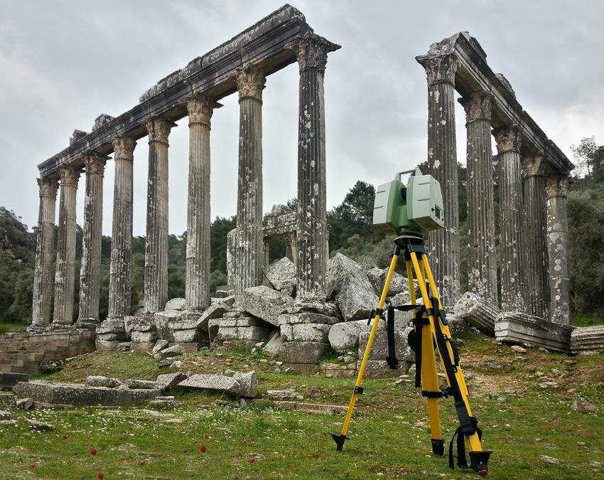
11 Working Fields for Surveying Engineers Restoration of historical monuments.

12 Working Fields for Surveying Engineers To make decision maps for deciding the shortest and quickest paths

13 Choosing an office with the best view

14 Definition of Surveying Engineering It is the art of Measuring physical and spatial parameters of objects belong to the space and earth, and gathering these data Evaluation and analysis of measurements Storing the results in the databases Presenting the results.
15 Works with It is a multidisciplinary area that works with Civil engineers, Geology, Forestry, Computer Engineering,etc. Also take advantage of Maths Physics Computer science ect.

16 Methods used in Surveying Electromagnetic,Laser and optical measurements


17 Methods used in Surveying GPS InSAR

18 Ground Measuring Instruments used in Surveying
19 Fields of Surveying Engineering Geodesy Surveying Cartography Remote Sensing Photogrammetry Land managment
20 Surveying It is the art of measuring horizontal and vertical distances between objects, of measuring angles between lines, of determining the direction of lines, and of establishing points by predetermined angular and linear measurements. Surveying has to do with the determination of the relative spatial location of points on or near the surface of the earth. Along with the actual survey measurements are the mathematical calculations. Distances, angles, directions, locations, elevations, areas, and volumes are thus determined from the data of the survey. Survey data is portrayed graphically by the construction of maps, profiles, cross sections, and diagrams.
21 Importance of Surveying Map the earth above and below sea level Prepare navigational charts for use in the air, on land, and at sea Establish property boundaries of private and public lands Develop data banks of land-use and natural resource information Determine size, shape, gravity, and magnetic fields of the earth Prepare charts of moon and planets


22 Types of Surveys Geodetic Surveying : It is the type of surveying that takes into account the true shape of the earth. These surveys are of high precision and extend overlarge areas. Plane Surveying : It is the type of surveying in which the mean surface of the earth is considered as a plane, or in which its spheroidal shape is neglected, with regard to horizontal distances and directions.
23 Different methods of Surveying Control Survey: Made to establish the horizontal and vertical positions of arbitrary points. Boundary Survey: Made to determine the length and direction of land lines and to establish the position of these lines on the ground. Topographic Survey: Made to gather data to produce a topographic map showing the configuration of the terrain and the location of natural and man-made objects. Hydrographic Survey: The survey of bodies of water made for the purpose of navigation, water supply, or sub-aqueous construction. Mining Survey: Made to control, locate and map underground and surface works related to mining operations.
24 Different methods of Surveying Construction Survey: Made to lay out, locate and monitor public and private engineering works. Route Survey: Refers to those control, topographic, and construction surveys necessary for the location and construction of highways, railroads, canals, transmission lines, and pipelines. Photogrammetric Survey: Made to utilize the principles of aerial photogrammetry, in which measurements made on photographs are used to determine the positions of photographed objects. Astronomical survey: generally involve imaging or "mapping" of regions of the sky using telescopes.

25 Shape of the earth GEOID: is a surface coinciding with mean sea-level (MSL) in the oceans, and lying under the land. It is an equipotential gravitational surface located approximately at mean sea level, which is everywhere perpendicular to the direction of gravity. Because of variations in the Earth s mass distribution and rotation of the Earth, the geoid has an irregular shape
26 Geoid and Elipsoid ELLIPSOID: It is a mathematical surface obtained by revolving an ellipse about the Earth s polar axis. The dimension of ellipse are selected to give a good fit of the ellipsoid to the geoid over a large area and are based upon surveys made in the area.
27 Geoid and Elipsoid A two-dimensional view, which illustrates the geoid and ellipsoid, is shown in figure. As illustrated, the geoid contains nonuniform undulations and is therefore not readily defined mathematically. Ellipsoids, which approximate the geoid and can be defined mathematically, are therefore used to compute positions of widely spaced points that are located through control surveys. Figure:3 (C.D. Ghilani, P.R. Wolf, 2008)
28 Geoid and Elipsoid Geoid has an irregular surface. Its surface does not follow the surface of ellipsoid. Sometimes it is below the ellipsoid and other times above it. Wherever the mass of earth s crust changes, the geoid s gravitational potential also changes, resulting in a nonuniform and unpredictable geoid surface. The surface of the earth has been approximately duplicated by the surface of an oblate ellipsoid, that is, the surface developed by rotating an ellipse on its minor axis. An ellipse was originally chosen that most closely conformed to the geoid of the area interest, which was usually continental in scope.
29 Geoid and Elipsoid If the solid earth was perfectly a spheroid, the geoid would be a perfect spheroid, but the irregularities in the shape and density cause the geoid to depart from the spheroidal form by amounts of 100 meters. For areas of limited size, the surface of our vast ellipsoid is actually nearly flat.the reference base for fieldwork, except leveling, and computations is assumed to be a flat horizontal surface. The direction of plump line (and thus gravity) is considered parallel throughout the survey region, and all angles are presumed to be a plane angles. In surveying lesson, focus on plane surveying.
30 UNITS OF MEASUREMENT Units of Length LINEER MEASUREMENT METRIC UNITS Kilometer 1000 meter 1 Hectometer 100 meter 1 Decameter 10 meter 1 Meter 100 centimeter 1 Decimeter 10 centimeter 1 Centimeter 10 milimeter 1 Milimeter 0,001 meter 1 Decimilimeter 0,1 milimeter 1 Centimilimeter 0,01 milimeter 1 Micrometer-micron 0,001 milimeter
31 UNITS OF MEASUREMENT Unit of Angular Measurement 1) Sexagesimal System This system uses angular notation in increments of 60 by dividing the circle into 360 degrees; degrees into 60 minutes; and minutes into 60 seconds. Each unit has a corresponding symbol: degrees are indicated by ( ) minutes by ( ' ); and seconds by ("). 1 Degree minutes 3600 second 1 Minute 1 ' 1/60 degree 60 seconds 1 Second 1 " 1/360 degree 1/60 minute 1 = 60'= 3600" 1' = 60"
32 UNITS OF MEASUREMENT As an example of preferred notation of angles with sexagesimal system; ' 43".6 Notice that minutes and seconds equal to or greater than 60 are carried over to the next larger unit and that degrees and minutes do not have decimals. decimal seconds are acceptable. For performing certain mathematical operations with angles, it is sometimes easier to convert to decimal degrees first, perform the necessary math, then convert back to degrees, minutes, and seconds. degrees minutes seconds '48" (58/60) + (48/3600) = decimal degrees
33 UNITS OF MEASUREMENT Unit of Angular Measurement 2) Hundreds System Grad System (gons) A grad is defined as 1/400 of a circle. A grad is dividing into 100 centigrad, centigrad into 100 centicentigrad. Grad is represented by the symbol (g), centigrad by (c), centicentigrad by (cc) Notation; 1 Grad 1g 100 centigrad 1000miligrad 10000centicentigrad 1 Centigrad 1 c 0,01 grad 10 miligrad 100 centicentigrad 1 Centicentigrad 1 cc 0,0001 grad g ( grad ) 133g 19c 32cc
34 UNITS OF MEASUREMENT Unit of Angular Measurement 3) Radian A radian is the defined as the angle between radius lines from either end of an arc of radius length. The circumference of a circle is twice the radius length times π, or C = 2πr. Therefore, 1 circle = 2π radians
35 UNITS OF MEASUREMENT Relation of angular units;
36 Kaynaklar Mualla Yalçınkaya, 2018, «Mühendisliğe Giriş» ders notları. Fundamentals of Surveying: Sample Examination,George M. Cole PE PLS Basic Surveying,Raymond E Paul (Author), Walter Whyte ITU DEPARTMENT OF GEOMATICS ENGINEERING
GEOMATICS ENGINEERING / SURVEYING
 1 GEOMATICS ENGINEERING / SURVEYING CHAPTER 1 Dr. Muhammad Ashraf Javid Assistant Professor Department of Civil and Environmental Engineering Email: muhammad.javid@unizwa.edu.om 2 Geomatics Engineering
GE 100: General Surveying I
 : General I INTRODUCTION TO SURVEYING Lecture No. Caraga State University College of Engineering and Information Technology SURVEYING It is the art and science of determining angular and linear measurements
CE 311. Elementary & Higher Surveying
 CE 311 Elementary & Higher Surveying Surveying Concept What do surveyors do? What do surveyors measure? What distances do surveyors measure? What angles do surveyors measure? What positions do surveyors
SURVEYING Chapter 1 Introduction
 PHILADELPHIA UNIVERSITY Faculty of Engineering. Department of Civil Engineering. SURVEYING Chapter 1 Introduction Surveying : the art or science of measuring and representing natural and artificial features
This week s topics. Week 6. FE 257. GIS and Forest Engineering Applications. Week 6
 FE 257. GIS and Forest Engineering Applications Week 6 Week 6 Last week Chapter 8 Combining and splitting landscape features and merging GIS databases Chapter 11 Overlay processes Questions? Next week
EnvSci360 Computer and Analytical Cartography
 EnvSci360 Computer and Analytical Cartography Lecture 3 Geodesy Map Projections, Datums, and Coordinate Systems 1 Geodesy The science of measuring and representing the shape and size of the earth, and
LECTURE NOTE ENGINEERING SURVEYING
 LECTURE NOTE ENGINEERING SURVEYING LECTURE 1 Introduction: Surveying is defined as taking a general view of, by observation and measurement determining the boundaries, size, position, quantity, condition,
What is Geodesy? Types of Geodesy terrestrial or classical geodesy space geodesy theoretical geodesy
 What is Geodesy? Geodesy is the study of: The size, shape and motion of the earth The measurement of the position and motion of points on the earth's surface, and The study of the earth's gravity field
International Journal of Computer Science and Telecommunications [Volume 3, Issue 7, July 2012] 109. Levelling with GPS. Dr. Nagi Zomrawi Mohammed
![International Journal of Computer Science and Telecommunications [Volume 3, Issue 7, July 2012] 109. Levelling with GPS. Dr. Nagi Zomrawi Mohammed](/thumbs/94/120062601.jpg "International Journal of Computer Science and Telecommunications [Volume 3, Issue 7, July 2012] 109. Levelling with GPS. Dr. Nagi Zomrawi Mohammed") International Journal of Computer Science and Telecommunications [Volume 3, Issue 7, July 2012] 109 ling with ISSN 2047-3338 Dr. Nagi Zomrawi Mohammed Associate Professor, College of Engineering, Sudan
International Journal of Computer Science and Telecommunications [Volume 3, Issue 7, July 2012] 109 ling with ISSN 2047-3338 Dr. Nagi Zomrawi Mohammed Associate Professor, College of Engineering, Sudan
Lesson 5: Map Scale and Projections
 Organizing Data and Information Lesson 5: Map Scale and Projections Map Scales Projections Information can be organized as lists, numbers, tables, text, pictures, maps, or indexes. Clusters of information
Exploring the boundaries of your built and natural world. Geomatics
 Exploring the boundaries of your built and natural world Geomatics Before the Luxor brought magic to the Las Vegas strip and before the South LRT extension in Edmonton gave residents a new route to travel,
Surveying I. Unit - I. Different methods and instruments are being used to facilitate the work of
 Surveying I Unit - I Definition of Survey Surveying is the art of determining the relative positions of different objects on the surface of the earth by measuring the horizontal distances between them,
1/28/16. EGM101 Skills Toolbox. Oblate spheroid. The shape of the earth Co-ordinate systems Map projections. Geoid
 EGM101 Skills Toolbox Oblate spheroid The shape of the earth Co-ordinate systems Map projections The geoid is the shape that the surface of the oceans would take under the influence of Earth's gravitation
Shape e o f f the e Earth
 1 Coordinate Systems & Projections Coordinate Systems Two map layers are not going to register spatially unless they are based on the same coordinate system. 2 Contents Shape of the earth Datum Projections
Introduction to Cartography GEOG 2016 E. Lecture-2 Geodesy and Projections
 Introduction to Cartography GEOG 2016 E Lecture-2 Geodesy and Projections What is Geodesy? The science of geodesy determines: Earth s shape and Interrelation of different points on earth s surface The
Ch2&3 Test. Multiple Choice Identify the choice that best completes the statement or answers the question.
 Ch2&3 Test Multiple Choice Identify the choice that best completes the statement or answers the question. 1. Earth s circumference is about 40,000 km, and its shape is a. an oval. c. a perfect sphere.
Lecture 4. Coordinate Systems & Projections
 Lecture 4 Coordinate Systems & Projections Outline Geodesy Geoids Ellipsoids Geographic Coordinate Systems Magnetic North vs. True North Datums Projections Applying Coordinate Systems and Projections Why
Evaluation of GPS in Orthometric Heights Determination in Khartoum State (Sudan)
") Evaluation of GPS in Orthometric Heights Determination in Khartoum State (Sudan) Dr. Nagi Zomrawi Mohammed 1, Dr. Abd Elrahim Elgizouli Mohammed 2 and Engineer Osman Bakry 3 1 Sudan University of Science
Evaluation of GPS in Orthometric Heights Determination in Khartoum State (Sudan) Dr. Nagi Zomrawi Mohammed 1, Dr. Abd Elrahim Elgizouli Mohammed 2 and Engineer Osman Bakry 3 1 Sudan University of Science
Test Bank Chapter 2: Representations of Earth
 Multiple Choice Test Bank Chapter 2: Representations of Earth 1. A rhumb line on a Mercator projection is a line of. a. true size b. true shape c. true compass bearing d. true location 2. Maximum longitude
12/26/2012. Geographic Information Systems * * * * GIS (... yrezaei
 ( - Geographic Information Systems ( ( 1 2 3 Information System Data base DB IS IS DB (Knowledge ( ( (System (Information System - (Georefrence Analysis Data + Knowledge ======== Information 4 5 ( < 10%
Basic Principles of Surveying and Mathematics
 AMRC 2012 MODULE 1 Basic Principles of Surveying and Mathematics CONTENTS Overview... 1-1 Objectives... 1-1 Procedures... 1-1 1.1 Surveying Defined... 1-3 1.2 Types of Surveys... 1-5 1.3 Precision and
4 Survey Datums. 4.1 Horizontal Datum Policy SURVEY DATUMS SEPTEMBER 2006
 4 Survey Datums Today s multi-organizational Project Development efforts require the use of common, accurate horizontal and vertical survey datums and consistent, precise control-survey procedures to ensure
Boolean Operators and Topological OVERLAY FUNCTIONS IN GIS
 Boolean Operators and Topological OVERLAY FUNCTIONS IN GIS Query asking a question of the attribute data Standard Query Language (SQL) is used to query the data There are 4 basic statements used to get
Chapter 3 Models of the Earth. 3.1 Finding Locations on the Earth. 3.1 Objectives
 Chapter 3 Models of the Earth 3.1 Finding Locations on the Earth 3.1 Objectives Explain latitude and longitude. How can latitude and longitude be used to find locations on Earth? How can a magnetic compass
Why do we need measurements?
 Why do we need measurements? Some of the earliest surviving measuring devices include gold scales recovered in present-day Greece from the tombs of Mycenaean kings. The tombs of Egyptian pharaohs the pyramids
The Earth is a Rotating Sphere
 The Earth is a Rotating Sphere The Shape of the Earth Earth s Rotation ( and relative movement of the Sun and Moon) The Geographic Grid Map Projections Global Time The Earth s Revolution around the Sun
The Elements of GIS. Organizing Data and Information. The GIS Database. MAP and ATRIBUTE INFORMATION
 GIS s Roots in Cartography Getting Started With GIS Chapter 2 Dursun Z. Seker MAP and ATRIBUTE INFORMATION Data (numbers and text) store as files refer to them collectively as a database gather inform.
Illustrator: Vector base Each line/point store some sort of information Mapping Representation of the world
 Illustrator: Vector base Each line/point store some sort of information Mapping Representation of the world Photoshop Raster base Images can be overlaid Pixel vector data model: [data models] A representation
Height systems. Rüdiger Gens
 Rüdiger Gens 2 Outline! Why bother about height systems?! Relevant terms! Coordinate systems! Reference surfaces! Geopotential number! Why bother about height systems?! give a meaning to a value defined
Fundamentals of Surveying (LE/ESSE )
") Fundamentals of Surveying (LE/ESSE 2620 3.0) Lecture 2 Basics of Surveying Dr.-Ing. Jian-Guo Wang Geomatics Engineering York University Fall 2017 1 2-1. Overview Part 1: Basics - The Earth s Shape & Size.
Fundamentals of Surveying (LE/ESSE 2620 3.0) Lecture 2 Basics of Surveying Dr.-Ing. Jian-Guo Wang Geomatics Engineering York University Fall 2017 1 2-1. Overview Part 1: Basics - The Earth s Shape & Size.
Why do we need measurements?
 CIVL 1101 Surveying - Introduction 1/5 Why do we need measurements? In science, measurement is the process of estimating or determining the magnitude of a quantity, such as length or mass, relative to
Themes for Geomatics Conference. Geodesy Themes
 Themes for Geomatics Conference Geodesy Themes Geodynamics o Modeling the Deformation of the Earth s Crust o Recent Advances in Geometric Approaches to Deformation Analysis o Monitoring Systems (Sensors
GEOGRAPHIC COORDINATE SYSTEMS
 GEOGRAPHIC COORDINATE SYSTEMS Introduction to GIS Winter 2015 What is Georeferencing? Used to establish a location on the Earth s surface 1 st order polynomial transformation Georeferencing toolbar What
GPS Surveying Dr. Jayanta Kumar Ghosh Department of Civil Engineering Indian Institute of Technology, Roorkee. Lecture 06 GPS Position
 GPS Surveying Dr. Jayanta Kumar Ghosh Department of Civil Engineering Indian Institute of Technology, Roorkee Lecture 06 GPS Position Friends! Welcome you to sixth class on GPS surveying. Today, I am going
Earth Science Review Ch 1 & 2. Chapter 1 - Introduction to Earth Science
 Earth Science Review Ch 1 & 2 Chapter 1 - Introduction to Earth Science Lesson I - What is Earth Science Topic 1- Branches of Earth Science Earth Science - the study of Earth, its oceans, atmosphere, and
17. According to the data below, what is the exact shape of the Earth?
 1. The Earth is slightly flattened from a perfect spherical shape because of A) its rotation B) the pull of the sun and moon C) storms on the sun's surface D) its molten core 2. Which diagram most accurately
A Preliminary Attempt of a Quasi-Geoid for Saudi Arabia
 A Preliminary Attempt of a Quasi-Geoid for Saudi Arabia Saad MOGREN, Saudi Arabia Key words: Geoid, Saudi Arabia, SUMMARY This proposal describes the need to undertake a national geoid (quasi-geoid) model
Tonight. {01} The map. Relative space. What does a map do? Types of maps GEOG 201 2/17/2010. Instructor: Pesses 1
 Tonight {01} The map What makes a map Measuring the Earth Map Interpretation & GPS Spring 2010 M. Pesses What does a map do? Shows where things are Shows spatial (topological) relationships Shows patterns,
GEOID UNDULATIONS OF SUDAN USING ORTHOMETRIC HEIGHTS COMPARED WITH THE EGM96 ANG EGM2008
 GEOID UNDULATIONS OF SUDAN USING ORTHOMETRIC HEIGHTS COMPARED Dr. Abdelrahim Elgizouli Mohamed Ahmed* WITH THE EGM96 ANG EGM2008 Abstract: Positioning by satellite system determine the normal height above
DOWNLOAD PDF PLANE AND GEODETIC SURVEYING FOR ENGINEERS
 Chapter 1 : Difference Between Plane Surveying and Geodetic Surveying Geodetic surveying. Effect of the curvature of the earth surface is ignored. The earth surface is assumed to be plane, i.e. two dimensional.
What is Geography? Lecture 1 The Earth As A Rotating Planet. What is Geography? What is geography? Subfields of Geography?
 Lecture 1 The Earth As A Rotating Planet Geog210 Physical Geography What is Geography? Much more than place names and locations The study of spatial variation How and why things differ from place to place
Outline. Shape of the Earth. Geographic Coordinates (φ, λ, z) Ellipsoid or Spheroid Rotate an ellipse around an axis. Ellipse.
 Ellipsoid or Spheroid Rotate an ellipse around an axis. Ellipse.") Map Projections Outline Geodesy and map projections Prof. D. Nagesh Kumar Department of Civil Engineering Indian Institute of Science Bangalore 560 012, India http://www.civil.iisc.ernet.in/~nagesh Shape
Map Projections Outline Geodesy and map projections Prof. D. Nagesh Kumar Department of Civil Engineering Indian Institute of Science Bangalore 560 012, India http://www.civil.iisc.ernet.in/~nagesh Shape
SiRF White Paper. Great Circle Distances Computing the distance between two points on the surface of the Earth
 SiRF White Paper Great Circle Distances Computing the distance between two points on the surface of the Earth Carl Carter May 17, 2002 Introduction The distance between two points on the Earth is computed
USING LIDAR MEASUREMENTS FOR IMPROVING OR UP-DATING A DEM
 JAES_1(14)_3_2011 VAIS M. et. all, pp.123-128 SECTION Geodesic Engineering USING LIDAR MEASUREMENTS FOR IMPROVING OR UP-DATING A DEM VAIS Manuel*, IOSIF Gheorghe, Bucharest University, *e-mail: manuel.vais@sipg.ro
Presented at the FIG Congress 2018, May 6-11, 2018 in Istanbul, Turkey
 Presented at the FIG Congress 2018, May 6-11, 2018 in Istanbul, Turkey GIS Application in Technical and Environmental Safety of Natural Gas Transmission Pipelines, a Case Study Tuncer OZERBIL GEOGIS GIS
Precalculus Lesson 6.1: Angles and Their Measure Mrs. Snow, Instructor
 Precalculus Lesson 6.1: Angles and Their Measure Mrs. Snow, Instructor In Trigonometry we will be working with angles from We will also work with degrees that are smaller than Check out Shaun White s YouTube
Yrd. Doç. Dr. Saygın ABDİKAN Öğretim Yılı Güz Dönemi
 Yabancı Dil III (YDL285) Introduction to Geomatics Yrd. Doç. Dr. Saygın ABDİKAN 2017-2018 Öğretim Yılı Güz Dönemi 1 géomatique Geo (Earth) + informatics Geodesy + Geoinformatics Geomatics: The mathematics
CHAIRMAN OF THE JOINT CHIEFS OF STAFF INSTRUCTION
 CHAIRMAN OF THE JOINT CHIEFS OF STAFF INSTRUCTION J-3 CJCSI 3900.01C DISTRIBUTION: A, B, C, J POSITION (POINT AND AREA) REFERENCE PROCEDURES Reference: DODD 5105.60, 11 October 1996, National Imagery and
EARTHS SHAPE AND POLARIS PRACTICE 2017
 1. In the diagram below, letters A through D represent the locations of four observers on the Earth's surface. Each observer has the same mass. 3. Which diagram most accurately shows the cross-sectional
REFERENCING COORDINATE SYSTEMS MAP PROJECTIONS GEOREFERENCING
 GIS in Ecology SPATIAL REFERENCING COORDINATE SYSTEMS MAP PROJECTIONS GEOREFERENCING : :1 Where on earth? Early mapmakers recognized the need for a system that could locate features on the earth's surface.
Height systems. Rudi Gens Alaska Satellite Facility
 Rudi Gens Alaska Satellite Facility Outline Why bother about height systems? Relevant terms Coordinate systems Reference surfaces Geopotential number 2 Why bother about height systems? give a meaning to
GE 11 Overview of Geodetic Engineering. Florence A. Galeon Assistant Professor U.P. College of Engineering
 GE 11 Overview of Geodetic Engineering Florence A. Galeon Assistant Professor U.P. College of Engineering 1 Outline I. Five Major Fields of Geodetic Engineering II. Overview of Surveying III. Overview
Coordinate Systems. Location on earth is defined by coordinates
 Coordinate Systems We think of the earth as a sphere It is actually a spheroid (ellipsoid), slightly larger in radius at the equator than at the poles Shape of the Earth Location on earth is defined by
AGE 303 AGRICULTURAL LAND SURVEYING INTRODUCTION Land Surveying: It has to do with the determination of relative spatial location of points on or
 AGE 303 AGRICULTURAL LAND SURVEYING INTRODUCTION Land Surveying: It has to do with the determination of relative spatial location of points on or near the surface of the earth. It is the art of measuring
First on the Ground. Geomatics
 First on the Ground Geomatics Surveying and mapping solutions spanning the entire project lifecycle Part art, part science, part technology, the Geomatics profession is constantly evolving. From the very
Lecture 2. Map Projections and GIS Coordinate Systems. Tomislav Sapic GIS Technologist Faculty of Natural Resources Management Lakehead University
 Lecture 2 Map Projections and GIS Coordinate Systems Tomislav Sapic GIS Technologist Faculty of Natural Resources Management Lakehead University Map Projections Map projections are mathematical formulas
Mapping Earth. How are Earth s surface features measured and modeled?
 Name Mapping Earth How are Earth s surface features measured and modeled? Before You Read Before you read the chapter, think about what you know about maps Record your thoughts in the first column Pair
NAVIGATION THEORY QUESTIONS Basics of Navigation
 NAVIGATION THEORY QUESTIONS Basics of Navigation Q610065 look at it The angle between the plane of the ecliptic and the plane of equator is approx? 23.5 degrees In which two months of the year is the difference
Topographic Map Series:
 DEFINITION OF A MAP A MAP IS A GEOGRAPHIC PREPRESENTATION OF A PORTION OF THE EARTH S SURFACE DRAWN TO SCALE, AS SEEN FROM ABOVE. IT S USES COLORS, SYMBOLS AND LABELS TO REPRESENT FEATURES FOUND ON THE
Data acquisition and integration 1.
 Data acquisition and integration 1. Ferenc Végső Data acquisition and integration 1.: Ferenc Végső Lector: Árpád Barsi This module was created within TÁMOP - 4.1.2-08/1/A-2009-0027 "Tananyagfejlesztéssel
Information in Radio Waves
 Teacher Notes for the Geodesy Presentation: Possible discussion questions before presentation: - If you didn t know the size and shape of the Earth, how would you go about figuring it out? Slide 1: Geodesy
The courses presently offered in the Geomatics Engineering Program by the Department of Geodesy and Geomatics Engineering are described below.
 GGE GEODESY AND GEOMATICS ENGINEERING The courses presently offered in the Geomatics Engineering Program by the Department of Geodesy and Geomatics Engineering are described below. The first digit of the
MAPS AND THEIR CLASSIFICATION
 MAPPING MAPS AND THEIR CLASSIFICATION WHAT IS A MAP? A map is representation of the Earth's surface, showing how things are related to each other by distance, direction, and size. Maps are a way of showing
GISC3325 Class 2 - Latitude and Longitude on Sphere. 28 January 2013
 GISC3325 Class 2 - Latitude and Longitude on Sphere 28 January 2013 Geodesy Defined The science describing the size, shape and gravity field of the Earth in its threedimensional time-varying states. Branch
The Wildlife Society Meet and Greet. Come learn about what the UNBC Student Chapter of TWS is all about!
 Georeferencing I GEOG 300, Lecture 4 Dr. Anthony Jjumba 1 The Wildlife Society Meet and Greet Quiz Come learn about what the UNBC Student Chapter of TWS is all about! 5:30 7:30 PM, Wednesday September
Geographic coordinate systems
 1 Geographic coordinate systems In this chapter you ll learn about longitude and latitude. You ll also learn about the parts that comprise a geographic coordinate system including Spheres and spheroids
Lab Title: Parallax and Astronomical Distances. Equipment: Sextant Meter sticks (or tape measures) Calipers Magnetic compasses.
 Calipers Magnetic compasses.") Lab Title: Parallax and Astronomical Distances Equipment: Sextant Meter sticks (or tape measures) Calipers Magnetic compasses Introduction: Since we cannot travel to most celestial objects in order to
Lab Title: Parallax and Astronomical Distances Equipment: Sextant Meter sticks (or tape measures) Calipers Magnetic compasses Introduction: Since we cannot travel to most celestial objects in order to
Modern Navigation. Thomas Herring
 12.215 Modern Navigation Thomas Herring Today s Class Latitude and Longitude Simple spherical definitions Geodetic definition: For an ellipsoid Astronomical definition: Based on direction of gravity Relationships
ch02.pdf chap2.pdf chap02.pdf
 Introduction to Geographic Information Systems 8th Edition Karl Solutions Manual Full Download: http://testbanklive.com/download/introduction-to-geographic-information-systems-8th-edition-karl-solutions-manu
CE 316 GEOMATICS COURSE NOTES DR. MOIR D HAUG, C.L.S., P. ENG. JANUARY 2012
 CE 316 GEOMATICS COURSE NOTES DR. MOIR D HAUG, C.L.S., P. ENG. JANUARY 2012 0 COURSE INFORMATION Dr Moir D Haug, P. Eng University Office 2B25 Engineering 966 5355 moir.haug@usask.ca MDH Engineered Solutions
ECTS School of Rural and Surveying Engineering. 1 st SEMESTER Ι. Mandatory Courses A/A Code Courses Hours ECTS
 ECTS School of Rural and Surveying Engineering 1 st SEMESTER Ι. Mandatory Courses 1. 6209 Linear Algebra and Analytical 4 4,0 Geometry 2. 6210 Analysis 5 4,5 3. 6211 Introduction to Informatics 4 4,0 4.
Control Surveys and Coordinate Systems
 Control Surveys and Coordinate Systems The Earth is Round Basic Shape of the Earth: Oblate Spheroid of Revolution The length of the equatorial axis is approximately 27 miles greater than the polar axis.
What is a Map Projection?
 What is a Map Projection? It is how we represent a three dimensional Earth on a flat piece of paper However The process of transferring information from the Earth to a map causes every projection to distort
Lecture 10-14: Map Projections and Coordinate System
 URP 1281 Surveying and Cartography Lecture 10-14: Map Projections and Coordinate System December 27, 2015 Course Teacher: Md. Esraz-Ul-Zannat Assistant Professor Department of Urban and Regional Planning
Geo Referencing & Map projections CGI-GIRS 0910
 Geo Referencing & Map projections CGI-GIRS 0910 Where are you? 31UFT8361 174,7 441,2 51 58' NB 5 40' OL 2/60 Who are they? 3/60 Do geo data describe Earth s phenomena perfectly? Georeference systems ellipsoid
Shape of the Earth. Data Output by the Receiver
 It is quite common for confusion to arise about the process used during a hydrographic survey when GPS-derived water surface elevation is incorporated into the data as an RTK Tide correction. This article
Earth-Space Science 6 12
 Earth-Space Science 6 12 Section 08 1 Knowledge of the nature of science 1. Analyze processes of scientific inquiry. 2. Evaluate models used in science to explain patterns observed in nature (e.g., rock
Introduction to Geographic Information Science. Updates/News. Last Lecture. Geography 4103 / Map Projections and Coordinate Systems
 Geography 4103 / 5103 Introduction to Geographic Information Science Map Projections and Coordinate Systems Updates/News Thursday s lecture Reading discussion 1 find the readings online open questions,
Chapter 2. Altitude Measurement
 Chapter Altitude Measurement Although altitudes and zenith distances are equally suitable for navigational calculations, most formulas are traditionally based upon altitudes which are easily accessible
Data acquisition and integration 1.
 University of West Hungary, Faculty of Geoinformatics Ferenc Végső Data acquisition and integration 1. module DAI1 The basics of positioning SZÉKESFEHÉRVÁR 2010 The right to this intellectual property
GIS = Geographic Information Systems;
 What is GIS GIS = Geographic Information Systems; What Information are we talking about? Information about anything that has a place (e.g. locations of features, address of people) on Earth s surface,
Unit I: Earth Dimensions. Review Book pp.19-30
 Unit I: Earth Dimensions Review Book pp.19-30 Objective #1 Describe the actual shape of the Earth and explain 3 pieces of evidence for its actual shape. Earth s Shape The Earth appears to be the shape
Geo Referencing & Map projections CGI-GIRS 0910
 Geo Referencing & Map projections CGI-GIRS 0910 Where are you? 31UFT8361 174,7 441,2 51 58' NB 5 40' OL 2/60 Who are they? 3/60 Do geo data describe Earth s phenomena perfectly? Georeference systems ellipsoid
GPS ELLIPSOID HEIGHT CALIBRATION TO DETERMINE THE APPROXIMATE MEAN SEA LEVEL (ORTHOMETRIC) HEIGHT
 HEIGHT") GPS ELLIPSOID HEIGHT CALIBRATION TO DETERMINE THE APPROXIMATE MEAN SEA LEVEL (ORTHOMETRIC) HEIGHT Dr. Abd Elrahim Elgizouli Mohamed Ahamed* Abstract: Through this paper a comparison between the ellipsoidal
GPS ELLIPSOID HEIGHT CALIBRATION TO DETERMINE THE APPROXIMATE MEAN SEA LEVEL (ORTHOMETRIC) HEIGHT Dr. Abd Elrahim Elgizouli Mohamed Ahamed* Abstract: Through this paper a comparison between the ellipsoidal
Potential Theory and the Static Gravity Field of the Earth
 TOGP 00054 a0005 3.02 Potential Theory and the Static Gravity Field of the Earth C. Jekeli, The Ohio State University, Columbus, OH, USA ª 2007 Elsevier Ltd. All rights reserved. g0005 g0010 g0015 g0020
1. The bar graph below shows one planetary characteristic, identified as X, plotted for the planets of our solar system.
 1. The bar graph below shows one planetary characteristic, identified as X, plotted for the planets of our solar system. Which characteristic of the planets in our solar system is represented by X? A)
a system for input, storage, manipulation, and output of geographic information. GIS combines software with hardware,
 Introduction to GIS Dr. Pranjit Kr. Sarma Assistant Professor Department of Geography Mangaldi College Mobile: +91 94357 04398 What is a GIS a system for input, storage, manipulation, and output of geographic
An Introduction to Geographic Information System
 An Introduction to Geographic Information System PROF. Dr. Yuji MURAYAMA Khun Kyaw Aung Hein 1 July 21,2010 GIS: A Formal Definition A system for capturing, storing, checking, Integrating, manipulating,
Scientists observe the environment around them using their five senses.
 Earth Science Notes Topics 1: Observation and Measurement Topic 2: The Changing Environment Review book pages 1-38 Scientists observe the environment around them using their five senses. When scientists
QUANTITATIVE APTITUDE
 SBI Probationery Officers QUANTITATIVE APTITUDE Mensuration (Plane Figures) Mensuration is one of the branches of mathematics. This means measurement. It is being done in our life in many situations. Here,
4. Which object best represents a true scale model of the shape of the Earth? A) a Ping-Pong ball B) a football C) an egg D) a pear
 a Ping-Pong ball B) a football C) an egg D) a pear") Name Test on Friday 1. Which diagram most accurately shows the cross-sectional shape of the Earth? A) B) C) D) Date Review Sheet 4. Which object best represents a true scale model of the shape of the Earth?
Name Test on Friday 1. Which diagram most accurately shows the cross-sectional shape of the Earth? A) B) C) D) Date Review Sheet 4. Which object best represents a true scale model of the shape of the Earth?
Proceedings of the First International Conference on Civil Engineering, Assiut University, Volume 2, pp , October 7-8.
 Proceedings of the First International Conference on Civil Engineering, Assiut University, Volume 2, pp. 246-253, October 7-8. PRODUCTIVE GPS TOPOGRAPHIC MAPPING FOR NATIONAL DEVELOPMENT PROJECTS IN EGYPT
Solution for Homework# 3. Chapter 5 : Review & Discussion
 Solution for Homework# 3 Chapter 5 : Review & Discussion. The largest telescopes are reflecting telescopes, primarily because of 3 distinct disadvantages of the refracting telescope. When light passes
It is the art of determining the relative positions of natural and artificial features on the earth s surface, vertically and horizontally.
 SVG 105 Lectures Notes March 2011 BASIC INTRODUCTION TO SURVEYING DEFINITION OF SURVEYING It is the art of determining the relative positions of natural and artificial features on the earth s surface,
Projections & GIS Data Collection: An Overview
 Projections & GIS Data Collection: An Overview Projections Primary data capture Secondary data capture Data transfer Capturing attribute data Managing a data capture project Geodesy Basics for Geospatial
Last week we obtained a general solution: 1 cos αdv
 GRAVITY II Surface Gravity Anomalies Due to Buried Bodies Simple analytical solution may be derived for bodies with uniform density contrast simple shape, such as: Sphere Horizontal/vertical cylinders
GPS and Mean Sea Level in ESRI ArcPad
 Summary In order to record elevation values as accurately as possible with, it is necessary to understand how ArcPad records elevation. Rather than storing elevation values relative to Mean Sea Level (MSL),
AST 104 Lab 8: Hubble Deep Field & The Fate of the Universe
 Name: SUID: AST 104 Lab 8: Hubble Deep Field & The Fate of the Universe Introduction: One of the most revered images in all of Astronomy is the so called Hubble Deep Field image. Part of the Hubble Telescope
Mapping Earth. Technology and Mapmaking
 CHAPTER 1 LESSON 2 Mapping Earth Technology and Mapmaking Key Concepts What can a topographic map tell you about the shape of Earth s surface? What can you learn from geologic maps about the rocks near
LESSON 2: INTRODUCTION TO TOPOGRAPHICAL MAPS
 LESSON 2: INTRODUCTION TO TOPOGRAPHICAL MAPS Finding your way if you become separated from a group. PURPOSE This lesson presents an overview of topographic maps. It describes their characteristics and