It is the art of determining the relative positions of natural and artificial features on the earth s surface, vertically and horizontally.
|
|
|
- Justina Wood
- 5 years ago
- Views:
Transcription
1 SVG 105 Lectures Notes March 2011 BASIC INTRODUCTION TO SURVEYING DEFINITION OF SURVEYING It is the art of determining the relative positions of natural and artificial features on the earth s surface, vertically and horizontally. Land surveying has been defined as the art and science of determining the position of natural and artificial features on, above or below the earth s surface; and representing this information on paper plans, as figures in report tables or on computer based maps. This definition however would be seen as a very narrow view of what is encompassed by surveying today. The definition of surveying is changing, to reflect the applications of surveying techniques and the impact that the introduction of computer technology has had on the more traditional aspects of the discipline. Surveying may be defined as the science of determining the position, in three dimensions, of natural and man-made features on or beneath the surface of the Earth. These features may then be represented in analog form as a contoured map, plan or chart, or in digital form as a three-dimensional mathematical model stored in the computer. Surveying or land surveying is the technique and science of accurately determining the terrestrial or three-dimensional position of points and the distances and angles between them. These points are usually on the surface of the Earth, and they are often used to establish land maps and boundaries for ownership or governmental purposes. (Source: Wikipedia) CLASSES OF SURVEYING 1 (1) Plane Surveying In this class of survey the surface of the earth is considered to be a plane for all X and Y dimensions. Z dimensions are referred to the mean spherical surface of the earth (Mean Sea Level). The spherical shape of the earth is not considered. It is mostly applied in small scale surveys. (2) Geodetic Surveying This takes into account the true shape of the earth. That means curvature correction is applied to all measurements. Characteristics of this type of survey: - It covers large areas and is carried out at high precision. It is mainly used to establish Control points which are known in the vertical and horizontal dimensions. These control points are used in large scale mapping e.g. Trigonometrical Beacons. The above classes of survey can be divided into three main operations: (a) CONTROL SURVEY Establishing of permanent points whose planimetry positions and their elevations above mean sea level have been carefully determined.
2 (b) PRELIMINARY SURVEY The gathering of data to locate physical features, contouring spot heights so that the data can be plotted to scale on a map or plan. (c) LAYOUT SURVEY Marking on the ground features shown on a design plan or from an aerial photograph both horizontally and vertically. THE FUNDAMENTAL PRINCIPLES OF SURVEYING (1) No measurement is exact and that the true value of quantity being measured is never known (2) No measurement is acceptable or valid unless it has been followed by an independent check or by repeating the measurement a number of times. (3) Measurements should be precise and accurate. HISTORY OF SURVEYING The history of land surveying is very interesting and diverse and it is in fact one of the oldest professions in the world. The history of land surveying dates back thousands of years and forms of land surveying have been around since ancient man in all major civilizations across the globe. Surveying science has a very long and distinguished history, dating at least back to the rope stretchers of Babylonia and the Egyptian dynasties. The development of the principles of geometry, astronomy and time still forms the foundation on which current surveying knowledge is built. The first examples in the history of land surveying date back to the ancient Egyptians during the building of the Great Pyramid at Giza in 2700 BC. There is evidence of the Egyptians using basic geometry to redraw boundary lines when the Nile overflowed its banks. The Romans were the next civilization to advance on the initial land surveying techniques of the Egyptians. Historical evidence shows that the Roman Empire was the first civilization to employ an official land surveyor within their Empire. They used simple tools to create straight lines and angles. The land surveyors had a range of jobs in the Empire and some of their work is still evident today. Today surveyors use satellites to image the earth s environment, use different satellites for navigation and precise position fixing, use computer visualization techniques for mapping, micro-computer controlled equipment for measuring the earth s surface and information systems to present and analyse data about land and land usage. But, the underlying core of knowledge for all of this sophistication is the mathematics of geometry. TYPES OF SURVEYS [1] Control surveys. [2] Topographic. [3] Land, Boundary and Cadastral surveys. a. Original surveys. b. Retracement surveys. c. Subdivision surveys. 2
3 3 [4] Hydrographic surveys. [5] Route surveys. [6] Construction surveys. [7] As-build surveys. [8] Mine surveys.
4 IMPORTA CE OF SURVEYI G 4
5 U ITS OF MEASUREME T The system most commonly used in the measurement of distance and angle is the Systeme Internationale, abbreviated to SI. The basic units of prime interest are: Length in metres (m) from which we have: 1 m = 103 millimetres (mm) 1 m = 10 3 kilometres (km) ERRORS IN MEASUREMENT It should now be apparent that position fixing simply involves the measurement of angles and distance. However, all measurements, no matter how carefully executed, will contain error, and so the true value of a measurement is never known. It follows from this that if the true value is never known, the true error can never be known and the position of a point known only within certain error bounds. The sources of error fall into three broad categories, namely: (1) Natural errors caused by variation in or adverse weather conditions, refraction, gravity effects etc. (2) Instrumental errors caused by imperfect construction and adjustment of the surveying instruments used. (3) Personal errors caused by the inability of the individual to make exact observations due to the limitations of human sight, touch and hearing. CLASSIFICATION OF ERRORS MISTAKES are sometimes called gross errors, but should not be classified as errors at all. They are blunders, often resulting from fatigue or the inexperience of the surveyor. Typical examples are omitting a whole tape length when measuring distance, sighting the wrong target in a round of angles, reading 6 on a levelling staff as 9 and vice versa. Mistakes are the largest of the errors likely to arise, and therefore great care must be taken to obviate them. SYSTEMATIC ERRORS can be constant or variable throughout an operation and are generally attributable to known circumstances. The value of these errors can be calculated and applied as a correction to the measured quantity. They can be the result of natural conditions, examples of which are: refraction of light rays, variation in the speed of electromagnetic waves through the atmosphere, expansion or contraction of steel tapes due to temperature variations. In all these cases, corrections can be applied to reduce their effect. Such errors may also be produced by instruments, e.g. maladjustment of the theodolite or level, index error in spring balances, ageing of the crystals in EDM equipment. There is the personal error of the observer who may have a bias against setting a micrometer or in bisecting a target, etc. Such errors can frequently be selfcompensating; for instance, a person setting a micrometer too low when obtaining a direction will most likely set it too low when obtaining the second direction, and the resulting angle will be correct. Systematic errors, in the main, conform to mathematical and physical laws; thus it is argued that appropriate corrections can be computed and applied to reduce their effect. It is doubtful, however, whether the 5
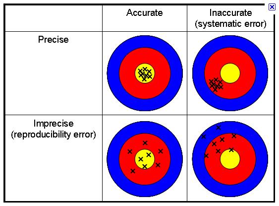
6 effect of systematic errors is ever entirely eliminated, largely due to the inability to obtain an exact measurement of the quantities involved. Typical examples are: the difficulty of obtaining group refractive index throughout the measuring path of EDM distances; and the difficulty of obtaining the temperature of the steel tape, based on air temperaturee measurements with thermometers. Thus, systematic errors are the most difficult to deal with and therefore they require very careful consideration prior to, during, and after the survey. Careful calibration of all equipment is an essential part of controlling systematic error. RANDOM ERRORS are those variates (errors) which remain after all other errors have been removed. They are beyond the control of the observer and result from the human inability of the observer to make exact measurements, for reasons already indicated above. Random variates are assumed to have a continuous frequency distribution called normal distribution and obey the law of probability. A random variate x, which is normally distributed with a mean and standard deviation, is written in symbol form as N (µ, 2). It should be fully understood that it is random errors alone which are treated by statistical processes. ACCURACY A D PRECISIO In the fields of science, engineering, industry and statistics, the accuracy of a measurement system is the degree of closeness of measurements of a quantity to its actual (true) value. The precision of a measurement system, also called reproducibility or repeatability, is the degree to which repeated measurements under unchanged conditions show the same results. Although the two words can be synonymous in colloquial use, they are deliberately contrasted in the context of the scientificc method. Accuracy indicates proximity of measurement results to the true value, precision to the repeatability or reproducibility of the measurement A measurement system can be accurate but not precise, precise but not accurate, neither, or both. For example, if an experiment contains a systematic error, then increasing the sample size generally increases precision but does not improve accuracy. Eliminating the systematic error improves accuracy but does not change precision. A measurement system is called valid if it is both accurate and precise. Related terms are bias (non-random or directed effects caused by a factor or factors unrelated by the independent variable) and error (random variability), respectively. The terminology is also applied to indirect measurements, that is, values obtained by a computational procedure from observed data. 6
7 7
Chapter 2. Theory of Errors and Basic Adjustment Principles
 Chapter 2 Theory of Errors and Basic Adjustment Principles 2.1. Introduction Measurement is an observation carried out to determine the values of quantities (distances, angles, directions, temperature
GE 100: General Surveying I
 : General I INTRODUCTION TO SURVEYING Lecture No. Caraga State University College of Engineering and Information Technology SURVEYING It is the art and science of determining angular and linear measurements
SURVEYING Chapter 1 Introduction
 PHILADELPHIA UNIVERSITY Faculty of Engineering. Department of Civil Engineering. SURVEYING Chapter 1 Introduction Surveying : the art or science of measuring and representing natural and artificial features
Why do we need measurements?
 Why do we need measurements? Some of the earliest surviving measuring devices include gold scales recovered in present-day Greece from the tombs of Mycenaean kings. The tombs of Egyptian pharaohs the pyramids
AGE 303 AGRICULTURAL LAND SURVEYING INTRODUCTION Land Surveying: It has to do with the determination of relative spatial location of points on or
 AGE 303 AGRICULTURAL LAND SURVEYING INTRODUCTION Land Surveying: It has to do with the determination of relative spatial location of points on or near the surface of the earth. It is the art of measuring
GEOMATICS ENGINEERING / SURVEYING
 1 GEOMATICS ENGINEERING / SURVEYING CHAPTER 1 Dr. Muhammad Ashraf Javid Assistant Professor Department of Civil and Environmental Engineering Email: muhammad.javid@unizwa.edu.om 2 Geomatics Engineering
Surveying, Surveyors and. Systems. Curt Crow NOAA s National Geodetic Survey September 22, 2009 URISA New England, Bedford, NH
 Surveying, Surveyors and Geographic Information Systems Curt Crow NOAA s National Geodetic Survey September 22, 2009 URISA New England, Bedford, NH Surveying The technique and science of accurately determining
CE 311. Elementary & Higher Surveying
 CE 311 Elementary & Higher Surveying Surveying Concept What do surveyors do? What do surveyors measure? What distances do surveyors measure? What angles do surveyors measure? What positions do surveyors
Introduction to Land Measurement (Field Surveying and Navigation)
") Introduction to Land Measurement (Field Surveying and Navigation) ESRM 304 Peter Schiess / Eric Turnblom 1 of 37 Overview Overview of surveying Survey mathematics Collecting and recording data Correcting
Introduction to Land Measurement (Field Surveying and Navigation) ESRM 304 Peter Schiess / Eric Turnblom 1 of 37 Overview Overview of surveying Survey mathematics Collecting and recording data Correcting
Basic Principles of Surveying and Mathematics
 AMRC 2012 MODULE 1 Basic Principles of Surveying and Mathematics CONTENTS Overview... 1-1 Objectives... 1-1 Procedures... 1-1 1.1 Surveying Defined... 1-3 1.2 Types of Surveys... 1-5 1.3 Precision and
Surveying I. Unit - I. Different methods and instruments are being used to facilitate the work of
 Surveying I Unit - I Definition of Survey Surveying is the art of determining the relative positions of different objects on the surface of the earth by measuring the horizontal distances between them,
LECTURE NOTE ENGINEERING SURVEYING
 LECTURE NOTE ENGINEERING SURVEYING LECTURE 1 Introduction: Surveying is defined as taking a general view of, by observation and measurement determining the boundaries, size, position, quantity, condition,
COPYRIGHTED MATERIAL INTRODUCTION CHAPTER 1
 CHAPTER 1 INTRODUCTION 1.1 INTRODUCTION We currently live in what is often termed the information age. Aided by new and emerging technologies, data are being collected at unprecedented rates in all walks
COPYRIGHTED MATERIAL INTRODUCTION CHAPTER 1
 CHAPTER 1 INTRODUCTION 1.1 INTRODUCTION We currently live in what is often termed the information age. Aided by new and emerging technologies, data are being collected at unprecedented rates in all walks
Why do we need measurements?
 CIVL 1101 Surveying - Introduction 1/5 Why do we need measurements? In science, measurement is the process of estimating or determining the magnitude of a quantity, such as length or mass, relative to
CHENDU COLLEGE OF ENGINEERING & TECHNOLOGY DEPARTMENT OF CIVIL ENGINEERING SUB CODE & SUB NAME : CE6404 SURVEYING II
 CHENDU COLLEGE OF ENGINEERING & TECHNOLOGY DEPARTMENT OF CIVIL ENGINEERING SUB CODE & SUB NAME : CE6404 SURVEYING II UNIT I CONTROL SURVEYING PART A (2 MARKS) 1. What is the main principle involved in
UNIT 1- CONTROL SURVEYING PART A
 QUESTION BANK (As per Anna University 2013 Regulation) UNIT 1- CONTROL SURVEYING Horizontal and vertical control Methods specifications triangulation- baseline instruments and accessories corrections satellite
Aim: to give a description of the sources and significance of errors and an understanding of accuracy and precision of measurements.
 ACET108 SURVEYING I Sources of errors Precision and Accuracy Trigonometry A. Sources of Errors Aim: to give a description of the sources and significance of errors and an understanding of accuracy and
Exploring the boundaries of your built and natural world. Geomatics
 Exploring the boundaries of your built and natural world Geomatics Before the Luxor brought magic to the Las Vegas strip and before the South LRT extension in Edmonton gave residents a new route to travel,
SURVEYING II-2MARKS UNIT-I. 2-Marks
 SURVEYING II-2MARKS UNIT-I 2-Marks 1. Define Tacheometry: Tacheometry is a branch of angular surveying in which the horizontal and vertical distances (or) points are obtained by optional means as opposed
Geographical Information System (GIS) Prof. A. K. Gosain
 Prof. A. K. Gosain") Geographical Information System (GIS) Prof. A. K. Gosain gosain@civil.iitd.ernet.in Definition of GIS GIS - Geographic Information System or a particular information system applied to geographical data
Geographical Information System (GIS) Prof. A. K. Gosain gosain@civil.iitd.ernet.in Definition of GIS GIS - Geographic Information System or a particular information system applied to geographical data
Surveying Prof. Bharat Lohani Department of Civil Engineering Indian Institute of Technology, Kanpur. Module - 3 Lecture - 4 Linear Measurements
 Surveying Prof. Bharat Lohani Department of Civil Engineering Indian Institute of Technology, Kanpur Module - 3 Lecture - 4 Linear Measurements Welcome again to this another video lecture on basic surveying.
Geography involves the study of places: their locations, their characteristics, and how humans use and move around them.
 Physical Geography Looking at the Earth Geography involves the study of places: their locations, their characteristics, and how humans use and move around them. NEXT Physical Geography Looking at the Earth
namibia UniVERSITY OF SCIEnCE AnD TECHnOLOGY
 namibia UniVERSITY OF SCIEnCE AnD TECHnOLOGY FACULTY OF NATURAL RESOURCES AND SPATIAL SCIENCES DEPARTMENT OF GEO-SPATIAL SCIENCES AND TECHNOLOGY QUALIFICATIONS: DIPLOMA IN GEOMATICS BACHELOR OF GEOMATICS
An Introduction to Statistics, Measurements and Error Theory
 An Introduction to Statistics, Measurements and Error Theory Washington Council of County Surveyors Survey Camp Presentation January 23, 2008 by Jon B. Purnell, PLS 1 There are three kinds of lies: lies,
UNITED NATIONS E/CONF.96/CRP. 5
 UNITED NATIONS E/CONF.96/CRP. 5 ECONOMIC AND SOCIAL COUNCIL Eighth United Nations Regional Cartographic Conference for the Americas New York, 27 June -1 July 2005 Item 5 of the provisional agenda* COUNTRY
Measurement of Horizontal Distances. the distance between two points means the horizontal distance
 Measurement of Horizontal Distances the distance between two points means the horizontal distance Pacing Mechanical Devices Taping * Tachymetric Photogrammetric * Electronic Distance Measurement (EDM)
Shape of the Earth. Data Output by the Receiver
 It is quite common for confusion to arise about the process used during a hydrographic survey when GPS-derived water surface elevation is incorporated into the data as an RTK Tide correction. This article
IC ARTICLE LAND SURVEYORS
 IC 25-21.5 ARTICLE 21.5. LAND SURVEYORS IC 25-21.5-1 Chapter 1. Definitions IC 25-21.5-1-1 Application of chapter Sec. 1. The definitions in this chapter apply throughout this article. As added by P.L.23-1991,
Georeferencing, Map Projections, Cartographic Concepts. -Coordinate Systems -Datum
 Georeferencing, Map Projections, Cartographic Concepts -Map Projections -Coordinate Systems -Datum Map projection is "the process of systematically transforming positions on the Earth's spherical surface
Use of Government Land Office Surveys in Tribal GIS Land Management. Dustin Holt GIS Technician Choctaw Nation of Oklahoma
 Use of Government Land Office Surveys in Tribal GIS Land Management Dustin Holt GIS Technician Choctaw Nation of Oklahoma Ardmore Quadrangle - 1949 Different versions of the same map were printed in 1901,
GEOMATICS ENGINEERING
 GEOMATICS ENGINEERING CHAPTER 2 Direct and Indirect Distance Measurement Methods Distance Measurement Methods Equipment Classification Usage Fieldwork procedure Booking system Adjustment and plotting Introduction
Measurement Year 10. The topic Measurement includes units because any size has no meaning without the units. Every answer must include the units used.
 Measurement Year 10 The topic Measurement includes units because any size has no meaning without the units. Every answer must include the units used. Precision and Estimation In general students should
Take the measurement of a person's height as an example. Assuming that her height has been determined to be 5' 8", how accurate is our result?
 Error Analysis Introduction The knowledge we have of the physical world is obtained by doing experiments and making measurements. It is important to understand how to express such data and how to analyze
Erosional Features. What processes shaped this landscape?
 Have you ever looked at the land around you and wondered what processes shaped what you see? Perhaps you see mountains, valleys, rivers, or canyons. Do you know how long these geologic features have been
S U R V E Y I N G. Lecture Notes. Draft
 S U R V E Y I N G Lecture Notes Draft 1 Introduction efinition of urveying Surveying (Land Surveying in the US) is the art of making measurements of relative positions of natural and man-made features
INTRODUCTION TO ENGINEERING SURVEYING (CE 1305)
") INTRODUCTION TO ENGINEERING SURVEYING (CE 1305) Linear Measurements Sr Dr. Tan Liat Choon Email: tanliatchoon@gmail.com Mobile: 016-4975551 1 EDM, TOTAL STATION, PRISM AND POLE 2 ELECTROMAGNETIC DISTANCE
INTRODUCTION TO ENGINEERING SURVEYING (CE 1305) Linear Measurements Sr Dr. Tan Liat Choon Email: tanliatchoon@gmail.com Mobile: 016-4975551 1 EDM, TOTAL STATION, PRISM AND POLE 2 ELECTROMAGNETIC DISTANCE
PRIMARY CONTROL SURVEYS
 STATE CONTROL SURVEY SPECIFICATIONS FOR PRIMARY CONTROL SURVEYS Now Obsolete Caution: This document has been prepared by scanning the original Specifications for Primary Control Surveys - 1984 and using
Lecture 9: Reference Maps & Aerial Photography
 Lecture 9: Reference Maps & Aerial Photography I. Overview of Reference and Topographic Maps There are two basic types of maps? Reference Maps - General purpose maps & Thematic Maps - maps made for a specific
Unit 1. Math 116. Number Systems
 Unit Math Number Systems Unit One Number Systems Sections. Introduction to Number Systems Through out history civilizations have keep records using their own number systems. This unit will introduce some
EROSIONAL FEATURES. reflect
 reflect Have you ever looked at the land around you and wondered what processes shaped what you see? Perhaps you see mountains, valleys, rivers, or canyons. Do you know how long these geologic features
Objective questions for Practical Examination (CBCS scheme) Introduction to Surveying CE-112
 Introduction to Surveying CE-112") Objective questions for Practical Examination (CBCS scheme) Introduction to Surveying CE-112 1. The curvature of the earth s surface, is taken into account only if the extent of survey is more than i)
Objective questions for Practical Examination (CBCS scheme) Introduction to Surveying CE-112 1. The curvature of the earth s surface, is taken into account only if the extent of survey is more than i)
Chapter 2. Altitude Measurement
 Chapter Altitude Measurement Although altitudes and zenith distances are equally suitable for navigational calculations, most formulas are traditionally based upon altitudes which are easily accessible
Reference Guide. Science Reference 9/25/ Copyright 1996 Gary Lewis Revisions 2007 by John Pratte
 Reference Guide Contents...1 1. General Scientific Terminology...2 2. Types of Errors...3 3. Scientific Notation...4 4. Significant Figures...6 5. Graphs...7 6. Making Measurements...8 7. Units...9 8.
Introduction To Metrology
 Introduction To Metrology Meaning of Metrology Metrology is the science of measurement. Metrology may be divided depending upon the quantity to be measured like metrology of length, metrology of time.
Correlation of WNCP Curriculum to Pearson Foundations and Pre-calculus Mathematics 10
 Measurement General Outcome: Develop spatial sense and proportional reasoning. 1. Solve problems that involve linear measurement, using: SI and imperial units of measure estimation strategies measurement
USING THE MILITARY LENSATIC COMPASS
 USING THE MILITARY LENSATIC COMPASS WARNING This presentation is intended as a quick summary, and not a comprehensive resource. If you want to learn Land Navigation in detail, either buy a book; or get
CE 316 GEOMATICS COURSE NOTES DR. MOIR D HAUG, C.L.S., P. ENG. JANUARY 2012
 CE 316 GEOMATICS COURSE NOTES DR. MOIR D HAUG, C.L.S., P. ENG. JANUARY 2012 0 COURSE INFORMATION Dr Moir D Haug, P. Eng University Office 2B25 Engineering 966 5355 moir.haug@usask.ca MDH Engineered Solutions
Correlation of Manitoba Curriculum to Pearson Foundations and Pre-calculus Mathematics 10
 Measurement General Outcome: Develop spatial sense and proportional reasoning. 10I.M.1. Solve problems that involve linear measurement, using: SI and imperial units of measure estimation strategies measurement
Only for Reference Page 1 of 11
 Only for Reference www.civilpddc2013.weebly.com Page 1 of 11 Seat No.: Enrolment No. PDDC - SEMESTER II EXAMINATION WINTER 2013 Subject Code: X20601 Date: 20-12-2013 Subject Name: Advance Surveying Time:
USING THE MILITARY LENSATIC COMPASS
 USING THE MILITARY LENSATIC COMPASS WARNING This presentation is intended as a quick summary, and not a comprehensive resource. If you want to learn Land Navigation in detail, either buy a book; or get
data becomes available to us. We already have crude maps of the Mars and the Moon. A map gives a picture of one or several of the elements of the
 FUNDAMENTALS OF MAPS THE SPHERICAL earth is best represented bya three-dimensional model of the earth, called a globe. All parts of the earth can be shown on it in their true shape, area and location along
History of Cartography,
 Maps History of Cartography, the art and science of making maps ~2300 BC ~600 BC Early oldest known maps: Babylonian clay tablets. Greek and Roman Ptolemy s (about AD 85-165) "world map" depicted the Old
Practice Questions - Revision
 Practice Questions - Revision Question 1: (a) The data from a survey, are shown below. Use either the Rise and Fall method or the Height of Plane of Collimation (HPC) method to reduce the data. Use arithmetic
MARINE GEODESY. by James C. T i s o n, J r. Director, U.S. Coast and Geodetic Survey
 MARINE GEODESY by James C. T i s o n, J r. Director, U.S. Coast and Geodetic Survey Reprinted, by kind permission, from Bulletin Géodésique, being the Journal of The International Association of Geodesy,
Unit 1 The Basics of Geography. Chapter 1 The Five Themes of Geography Page 5
 Unit 1 The Basics of Geography Chapter 1 The Five Themes of Geography Page 5 Geography comes from the Greek word geographia, which means to describe the earth. Geography is the study of the distribution
Chapter-2 Direct Measurement Indirect Measurement Method of linear measurement Taping corrections Optical measurement Tachometry EDM Measurement
 Chapter-2 Direct Measurement Indirect Measurement Method of linear measurement Taping corrections Optical measurement Tachometry EDM Measurement 1 2 3 4 5 6 7 Methods There are 3 methods of making linear
Leveling. 3.1 Definitions
 Leveling 3.1 Definitions Leveling is the procedure used to determine differences in elevation between points that are remote from each other. Elevation is a vertical distance above or below a reference
Colorado Academic Standards Summative Assessment Framework FINAL Science Grade 8
 Test 1 Physical Science 36% 22 7 29 1. Identify and calculate the direction and magnitude of forces that act on an object, and explain the results in the object s change of motion a. Predict and evaluate
DATA SOURCES AND INPUT IN GIS. By Prof. A. Balasubramanian Centre for Advanced Studies in Earth Science, University of Mysore, Mysore
 DATA SOURCES AND INPUT IN GIS By Prof. A. Balasubramanian Centre for Advanced Studies in Earth Science, University of Mysore, Mysore 1 1. GIS stands for 'Geographic Information System'. It is a computer-based
DOWNLOAD PDF PLANE AND GEODETIC SURVEYING FOR ENGINEERS
 Chapter 1 : Difference Between Plane Surveying and Geodetic Surveying Geodetic surveying. Effect of the curvature of the earth surface is ignored. The earth surface is assumed to be plane, i.e. two dimensional.
Site Surveying Procedures for Construction and the Built Environment
 Unit 27: Site Surveying Procedures for Construction and the Built Environment Unit code: R/601/1291 QCF level: 4 Credit value: 15 Aim This unit develops an understanding of the principles of site surveying
USING THE MILITARY LENSATIC COMPASS
 USING THE MILITARY LENSATIC COMPASS WARNING This presentation is intended as a quick summary, and not a comprehensive resource. If you want to learn Land Navigation in detail, either buy a book; or get
CE6404 SURVEYING II. 3. Arbitrary Bench Mark: When the RL of some fixed Points are assumed, they are termed a arbitrary Bench mark
 CE6404 SURVEYING II UNIT-I Control Surveying Part - A 1. Permanent Bench mark: These are established by different government departments like PWD, Railways, Irrigation etc., The RL of these points are
Surveying for Civil Engineering. Esra Tunc Gormus, PhD
 Surveying for Civil Engineering Esra Tunc Gormus, PhD Working Fields for Surveying Engineers It is also called as Geomatics Engineering or Geodesy and Photogrammetry Engineering Making maps with right
1. Origins of Geography
 II. ORIGINS AND BRANCHES OF GEOGRAPHY My Notes A. Origins of Geography Unit One 6 Before carefully examining the tools of the geographer, it would be useful to examine the origins and roots of this ancient
Source: Chapter 5: Errors in Chemical Analyses
 Source: Chapter 5: Errors in Chemical Analyses Measurements invariably involve errors and uncertainties. it is impossible to perform a chemical analysis that is totally free of errors or uncertainties
Surveyors, Cartographers, Photogrammetrists, and Surveying and Mapping Technicians
 http://www.bls.gov/oco/ocos040.htm Surveyors, Cartographers, Photogrammetrists, and Surveying and Mapping Technicians * Nature of the Work * Training, Other Qualifications, and Advancement * Employment
Shape e o f f the e Earth
 1 Coordinate Systems & Projections Coordinate Systems Two map layers are not going to register spatially unless they are based on the same coordinate system. 2 Contents Shape of the earth Datum Projections
 VALLIAMMAI ENGINEERING COLLEGE Department of Civil Engineering CE6304 SURVEYING I Questions Bank UNIT-I FUNDAMENTALS AND CHAIN SURVEYING Part A 1) Define surveying. 2) What are the types of surveying?
2 Foundations of physics Calculation sheet. OCR Physics A. Determining uncertainty. Specification references. Learning outcomes
 Determining uncertainty Specification references 2.2.1 c) M0.3 Use ratios, fractions, and percentages M1.5 Identify uncertainties in measurements and use simple techniques to determine uncertainty when
Map Reading & Navigation
 60 Chapter 6 Map Reading & Navigation Navigation is a skill which allows you to determine your own position and the location of your destination, on a map or on the ground, and to plan and follow the best
Course Instructions. 3 Easy Steps to Complete the Course: 1.) Read the Course PDF download from our website
 Read the Course PDF download from our website") Course Instructions NOTE: The following pages contain a preview of the final exam. This final exam is identical to the final exam that you will take online after you purchase the course. After you purchase
Course Instructions NOTE: The following pages contain a preview of the final exam. This final exam is identical to the final exam that you will take online after you purchase the course. After you purchase
Experimental Uncertainty (Error) and Data Analysis
 and Data Analysis") Experimental Uncertainty (Error) and Data Analysis Advance Study Assignment Please contact Dr. Reuven at yreuven@mhrd.org if you have any questions Read the Theory part of the experiment (pages 2-14) and
Experimental Uncertainty (Error) and Data Analysis Advance Study Assignment Please contact Dr. Reuven at yreuven@mhrd.org if you have any questions Read the Theory part of the experiment (pages 2-14) and
Geomatics: Geotechnologies in Action, Grade 12, University/College Expectations
 Geographic Foundations: Space and Systems SSV.01 explain how the earth is modelled for scientific and mapping purposes; SSV.02 demonstrate an understanding of basic spatial concepts; Page 1 SSV.03 explain
Class Objectives MISTAKES AND ERRORS MISTAKES AND ERRORS CE 211 SURVEYING ENGINEERING FALL 2011 CLASS 03: THEORY OF ERROS 8/26/2011
 8/6/011 Class Objectives CE 11 SURVEYING ENGINEERING FALL 011 CLASS 03: THEORY OF ERROS Ahmed Abdel-Rahim, Ph.D, P.E. Associate Professor, Civil Engineering Define mistakes and errors in measurements and
Surveying Prof. Bharat Lohani Department of Civil Engineering Indian Institute of Technology, Kanpur. Module - 11 Lecture No. # 01 Project surveys
 Surveying Prof. Bharat Lohani Department of Civil Engineering Indian Institute of Technology, Kanpur Module - 11 Lecture No. # 01 Project surveys (Refer Slide Time: 00:24) Welcome to this video lecture,
IMPLEMENTAION OF GIS TECHNOLOGY IN THE NILE AND ITS WADIS ABSTRACT
 IMPLEMENTAION OF GIS TECHNOLOGY IN THE NILE AND ITS WADIS Eng. NADIA M. ABD EI- SALAM 1 Dr. ABDEL AZIZ TAREK M. 2 ABSTRACT Traditional methods have been used for several years for map production of the
SPH3U UNIVERSITY PHYSICS
 SPH3U UNIVERSITY PHYSICS REVIEW: MATH SKILLS L (P.651; 653) Many people believe that all measurements are reliable (consistent over many trials), precise (to as many decimal places as possible), and accurate
Angelo Filomeno
 Angelo Filomeno www.angelofilomeno.com In these lectures we will cover : The role of linear measurement Equipment Procedures and rules Errors Applications of linear measurement 27.9 metres Simply the measurement
Year 3 The Ancient Egyptians
 Year 3 The Ancient Egyptians Spring Term Art Design and Technology Geography History Science National Curriculum Pupils should be taught: to create sketch books to record their observations and use them
Measurement Year 11. Rounding
 Measurement Year 11 Rounding Do not round early. Students should carry all decimal places in working until the end of their calculations. They should then give their answers sensibly rounded. An answer
AU-5029 GURU GHASIDAS VISHWAVIDYALAYA, BILASPUR (C.G.) INSTITUTE OF TECHNOLOGY DEPARTMENT OF CIVIL ENGINEERING B.TECH
 INSTITUTE OF TECHNOLOGY DEPARTMENT OF CIVIL ENGINEERING B.TECH") AU-5029 GURU GHASIDAS VISHWAVIDYALAYA, BILASPUR (C.G.) INSTITUTE OF TECHNOLOGY DEPARTMENT OF CIVIL ENGINEERING B.TECH 2 nd YEAR, III rd SEMESTER SUBJECT: SURVEYING-I COURSE CODE: 21CE02T Max Marks: 60
AU-5029 GURU GHASIDAS VISHWAVIDYALAYA, BILASPUR (C.G.) INSTITUTE OF TECHNOLOGY DEPARTMENT OF CIVIL ENGINEERING B.TECH 2 nd YEAR, III rd SEMESTER SUBJECT: SURVEYING-I COURSE CODE: 21CE02T Max Marks: 60
RECOMMENDATIONS FOR EUROPEAN MAGNETIC REPEAT STATION SURVEYS
 RECOMMENDATIONS FOR EUROPEAN MAGNETIC REPEAT STATION SURVEYS Andrzej Sas Uhrynowski, Monika Korte, Jean Jacques Schott and Gerhard Schwarz, Coordination Committee for common European repeat station surveys.
GEOMATICS SURVEYING AND MAPPING EXPERTS FOR OVER 35 YEARS
 GEOMATICS SURVEYING AND MAPPING EXPERTS FOR OVER 35 YEARS 2 GEOMATICS AND SURVEYING SOLUTIONS SPANNING THE ENTIRE PROJECT LIFECYCLE 1,000+ 250+ 24 Surveying professionals Active field crews Geomatics offices
Surveying Prof. Bharat Lohani Department of Civil Engineering Indian Institute of Technology, Kanpur. Module - 4 Lecture - 1 Compass Surveying
 Surveying Prof. Bharat Lohani Department of Civil Engineering Indian Institute of Technology, Kanpur Module - 4 Lecture - 1 Compass Surveying Welcome to this video lecture series on basic surveying and
Professional Land Surveyor
 Professional Land Surveyor Professional Land Surveyors establish official land, air space, and water boundaries. They write descriptions of land for deeds, leases, and other legal documents; define air
Appendix B: Skills Handbook
 Appendix B: Skills Handbook Effective communication is an important part of science. To avoid confusion when measuring and doing mathematical calculations, there are accepted conventions and practices
Technical Drafting, Geographic Information Systems and Computer- Based Cartography
 Technical Drafting, Geographic Information Systems and Computer- Based Cartography Project-Specific and Regional Resource Mapping Services Geographic Information Systems - Spatial Analysis Terrestrial
LECTURE 1 Engr. Meriam M. Santillan, M.Sc. Faculty
 LECTURE 1 Engr. Meriam M. Santillan, M.Sc. Faculty One of the oldest arts practiced by man From the earliest times it has always been important to mark boundaries and divided tracts of land. Through time,
Test Bank Chapter 2: Representations of Earth
 Multiple Choice Test Bank Chapter 2: Representations of Earth 1. A rhumb line on a Mercator projection is a line of. a. true size b. true shape c. true compass bearing d. true location 2. Maximum longitude
Scientific Literacy & the Scientific Method
 Scientific Literacy & the Scientific Method What does it mean to be? You ve probably hear that term before, and you might be thinking that literate means the ability to and. But what does it mean to be
THE QUALITY CONTROL OF VECTOR MAP DATA
 THE QUALITY CONTROL OF VECTOR MAP DATA Wu Fanghua Liu Pingzhi Jincheng Xi an Research Institute of Surveying and Mapping (P.R.China ShanXi Xi an Middle 1 Yanta Road 710054) (e-mail :wufh999@yahoo.com.cn)
International Journal of Computer Science and Telecommunications [Volume 3, Issue 7, July 2012] 109. Levelling with GPS. Dr. Nagi Zomrawi Mohammed
![International Journal of Computer Science and Telecommunications [Volume 3, Issue 7, July 2012] 109. Levelling with GPS. Dr. Nagi Zomrawi Mohammed](/thumbs/94/120062601.jpg "International Journal of Computer Science and Telecommunications [Volume 3, Issue 7, July 2012] 109. Levelling with GPS. Dr. Nagi Zomrawi Mohammed") International Journal of Computer Science and Telecommunications [Volume 3, Issue 7, July 2012] 109 ling with ISSN 2047-3338 Dr. Nagi Zomrawi Mohammed Associate Professor, College of Engineering, Sudan
International Journal of Computer Science and Telecommunications [Volume 3, Issue 7, July 2012] 109 ling with ISSN 2047-3338 Dr. Nagi Zomrawi Mohammed Associate Professor, College of Engineering, Sudan
The 3-D Global Spatial Data Model: Geometrical Foundation of the Global Spatial Data Infrastructure
 The 3-D Global Spatial Data Model: Geometrical Foundation of the Global Spatial Data Infrastructure Earl F. Burkholder, PS, PE Annotated Table of Contents July 8,2006 I. The Global Spatial Data Model (GSDM)
Three-Dimensional Aerial Zoning around a Lebanese Airport
 Three-Dimensional Aerial Zoning around a Lebanese Airport Abstract by Oussama C. Jadayel and Rita Y. Ibrahim GIS Center, Faculty of Engineering, University of Balamand, P.O. Box: 100, Tripoli, LEBANON
Chapter Chemistry is important. 1.2 The Scientific Method. Chapter 1 1. Fundamental Concepts and Units of Measurement
 Chapter 1 Fundamental Concepts and Units of Measurement 1 1.1 Chemistry is important Matter anything that takes up space and has mass Chemistry the science that deals with matter (the structure and properties
ESRI GIS For Mining Seminar, 10 th August, 2016, Nairobi, Kenya. Spatial DATA Solutions for Mining
 ESRI GIS For Mining Seminar, 10 th August, 2016, Nairobi, Kenya Spatial DATA Solutions for Mining Spatial Data Solutions for Mining Spatial - Data that identifies the geographic location of features &
NCEES FS Practice Exam
 NCEES FS Practice Exam Terrametra Resources Lynn Patten 1. One corner of a 60-ft. 120-ft. lot, otherwise rectangular, is a curve with a radius of 20 ft. and a central angle of 90. The area (ft. 2 ) of
FUNDAMENTAL CONCEPTS IN MEASUREMENT & EXPERIMENTATION (continued) Measurement Errors and Uncertainty:
 Measurement Errors and Uncertainty:") FUNDAMENTAL CNCEPTS N MEASUREMENT & EXPERMENTATN (continued) Measurement Errors and Uncertainty: The Error in a measurement is the difference between the Measured Value and the True Value of the Measurand.
FUNDAMENTAL CNCEPTS N MEASUREMENT & EXPERMENTATN (continued) Measurement Errors and Uncertainty: The Error in a measurement is the difference between the Measured Value and the True Value of the Measurand.