CHARACTERISTICS OF SNOW AND ICE MORPHOLOGICAL FEATURES DERIVED FROM MULTI-POLARIZATION TERRASAR-X DATA
|
|
|
- Abel Newton
- 5 years ago
- Views:
Transcription
 2 Enveo IT Innsbruck")
1 CHARACTERISTICS OF SNOW AND ICE MORPHOLOGICAL FEATURES DERIVED FROM MULTI-POLARIZATION TERRASAR-X DATA Dana Floricioiu 1, Helmut Rott 2, Thomas Nagler 2, Markus Heidinger 2 and Michael Eineder 1 1 DLR, Remote Sensing Technology Institute (IMF) 2 Enveo IT Innsbruck Austria
2 TerraSAR-X Basic Imaging Modes Stripmap (SM) Θ 1 =20 o High Resolution Spotlight (HS) & Spotlight (SL) ScanSAR (SC) >30 km Θ 2 =45 o 10 km 5-10 km 100 km Stripmap Spotlight (HS & SL) ScanSAR swath width (range) 30 km (single pol.) 15 km (dual pol.) MHz chirp BW azimuth: 5 / 10 km (HS / SL) 100 km (only single pol.) full performance incidence angle range azimuth resolution 3.3 m (single pol.) 6.6 m (dual pol.) 1.1 m / 2.2 m (HS, single / dual pol.) 1.7 m / 3.4 m (SL, single / dual pol.) 17 m (1 look, 4 beams) ground range 150 MHz chirp BW 1.7 m m (@ ) 1.5 m m (@ ) 1.7 m m (@ ) (nom.) product length 50 km 5 km/10 km 150 km polarizations: single HH or VV dual (HH/VV) (HH/HV) or (VV/VH), no cross-pol for SL,HS
3 TerraSAR-X full performance beams and incidence angle ranges* Imaging Mode Polarization Mode Full Performance Beam Configurations Incidence Angle (Look Angle) Range Stripmap single strip_003- strip_ ( ) Stripmap dual stripnear_003 - stripfar_ ( ) Spotlight & High-Resolution Spotlight single & dual spot_010 spot_ ( ) ScanSAR single scan_003 scan_ ( ) *for right looking mode These are the only beams which can be ordered by science users Folie 3

4 Used TerraSAR-X products Radiometric Enhanced (RE) variant Resolution*:7.6 to 10 m (decreased to reduce speckle) 1.5 db radiometric resolution Pixel spacing: 3.5 to 4.5 m No of looks: 5 to 7 ( e.g. 4.4rg x 1.4 az) *depending on the incidence angle Polarization: 1st acquisition HH/HV 2nd acquisition HH/VV one cycle (11 days) later
 Ice facies.")
5 Glaciers zones with characteristic backscatter properties Dry-snow facies Percolation facies Superimposed ice Wet snow facies (in summer) Ice facies. Glacier facies zones during the accumulation period Folie 5
6 Aim of the study Establish relationship between accumulation rate and backscattering on ice sheets and glaciers Snow properties of the dry snow zone Physical properties for medium characterization relevant for radar scattering: grain size and shape sequence, roughness and orientation of internal interfaces External processes determining the snow metamorphism air (and snow) temperature accumulation rate wind intensity and direction Folie 6


7 Dry snow zone Test site in Dronning Maud Land, Antarctica, 4 stations across the Heimefrontfjella Mts. Veststraumen 74.3S 13.7W TerraSAR-X coverage Base Camp 74.7S 12.6W Camp S 11.9W 15 km Amundsen Ice 75.3S 10.3W Folie 7
8 In situ measurements: vertical profiles of snow density Depth hoar layer Multi-year accumulation Veststraumen Base Camp Amundsen Ice Accumulation [kg m -2 a -1 ] Density (0-2 m) [kg m-3] m firn temperature [ C] Elevation a.s.l. [m] Folie 8

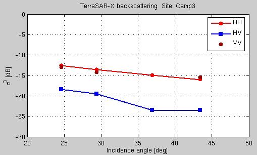
9 In situ measurements (1990) : scatterometer at X-band, VV, HH, VH and HV Incidence angle: deg Veststraumen Base Camp Amundsen Ice Folie 9


10 TerraSAR-X Veststraumen γ=σ 0 /cosθ } Scatt. az rg HH,HV,HH-HV
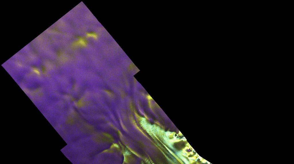
11 TerraSAR-X Base Camp Camp 3 Scatt. az rg HH,HV,HH-HV


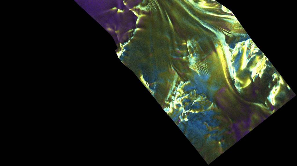
12 TerraSAR-X az rg } HH,HV,HH-HV Scatt. Amundsen Ice Details of the bedrock topography?


13 Dry snow zone Site along the traverse between Georg von Neumayer and Kottas camp 74 S 9.5 W TerraSAR-X Kottas camp 74.2S, 9.73W Accumulation [kg m -2 a -1 ] az rg


![-2 a -1 ] 350 130 Backscattering](/docs-images/93/111973468/images/14-3.jpg "profile 40km N of Kottas camp")

14 Backscattering profile in azimuth across Heimefrontfjella from North (left) to South (right) TerraSAR-X data , Incid. angle 30 deg. Veststraumen Base camp Camp 3 Amundsen Ice 260 Accumulation [kg m -2 a -1 ] Backscattering profile 40km N of Kottas camp TerraSAR-X , Incid. angle ~40 deg. Accumulation gradient 200 to 300 kg m -2 a -1


15 Percolation zone Test site: Sulztal - glacier in the Austrian Alps TerraSAR-X dual pol VV & VH on 15 January 2008 Winter fine grained snow covers the coarse grained snow (percolation zone) TerraSAR-X σ 0 VV θ i at image center 27 deg σ 0 VV Signature dominated by the scattering in the firn layer Folie 15
16 Modelling of X-Band backscatter from the percolation zone Input values for winter snow layer: Parameters DMRT Model Snow surface RMS height 0.2 cm Snow surface Correlation 8 cm length Grain shape Cylinder Grain equivalent radius Case 1: 0.4 mm Case 2: 0.6 mm Grain axis ratio (b/a) 0.5 Vertical profile of snow density and stratigraphy on Snow depth Snow density SWE Snow temperature 1.67 m 274 kg/m³ mm 7 C Folie 16
17 1st Order RT model calculations compared to TerraSAR-X Case 1: omega 0.4 Case 2: omega 0.5 omega - single scattering albedo TerraSAR-X data Good estimation of both VV and HV backscattering because the RT uses empirical relations for polarization behavior. DMRT underestimates σ 0 HV by several db. Folie 17
18 Model calculation for coarse grained snow (percolation zone) superimposed by 1 m of fine grained winter snow σ 0 of winter snow + coarse layer --- σ 0 of coarse layer At X-band weak sensitivity of the signal to accumulation of winter snow above the older one. Snow parameters DMRT Model Winter snow grain radius 0.2 mm Density 300 kg/m 3 Winter snow depth Grain radius in the percolation layer Grain radius in the winter snow Ellipsoid axis ratio (b/a) 1 m 1.0 mm 0.2 mm 0.5 Folie 18
19 Conclusions (1) For the dry snow facies the X-band backscatter signatures are related to mean accumulation rates of several years. the magnitude of co-and cross-polarized backscatter is inversely related to the accumulation rate. HH and VV polarized σ show very small differences. Co- and cross- polarized backscatter show minor decrease with increasing accumulation rate. The main snow properties of relevance for backscattering are: The sequence of internal layers (in particular the thickness of annual layers and related depth hoar layers). Size and shape of the snow grains in the layers. Azimuth orientation of sastrugi (in katabatic wind zones). Possibilities for combining X-band data with other frequencies for estimation of snow accumulation should be studied. Folie 19
20 Conclusions (2) For the percolation facies the X-band backscatter during the accumulation period (dry snow) is dominated by the signal of the refrozen firn. Accumulation of winter snow results in a small decrease of the total backscatter due to the reduced scattering albedo of the winter snow. At X-band this is a weak signal, increasing towards higher radar frequencies. The main snow properties of relevance for the retrieval of winter snow accumulation are similar as those in the dry snow zone: - Background signature of the frozen firn or ice surface. - Size and shape of the snow grains. - Sequence of internal layers (related to meteorological events). Folie 20
DLR/TerraSAR-X: development of IPY portofolio since the SAR coordination workshop (CSA, March 2008) Dana Floricioiu
 Dana Floricioiu") DLR/TerraSAR-X: development of IPY portofolio since the SAR coordination workshop (CSA, March 2008) Dana Floricioiu STG-3 Meeting, ESRIN Frascati 5/6 May 2008 Acquisitions themes adopted at the SAR coordination
DLR/TerraSAR-X: development of IPY portofolio since the SAR coordination workshop (CSA, March 2008) Dana Floricioiu STG-3 Meeting, ESRIN Frascati 5/6 May 2008 Acquisitions themes adopted at the SAR coordination
Feasibility of snow water equivalent retrieval by means of interferometric ALOS PALSAR data
 Feasibility of snow water equivalent retrieval by means of interferometric ALOS PALSAR data, Florian Müller, Helmut Rott, and Markus Heidinger ENVEO Technikerstrasse 21a, A 6020 Innsbruck, Austria www.galahad-euproject.org
Evaluation of sub-kilometric numerical simulations of C-band radar backscatter over the french Alps against Sentinel-1 observations
 Evaluation of sub-kilometric numerical simulations of C-band radar backscatter over the french Alps against Sentinel-1 observations Gaëlle Veyssière, Fatima Karbou, Samuel Morin, Matthieu Lafaysse Monterey,
SAR Coordination for Snow Products
 Polar SAR Coordination Working Meeting 5 SAR Coordination for Snow Products David Small 1, Thomas Nagler 2, David Jäger 1, Christoph Rohner 1, Adrian Schubert 1 1: University of Zurich, Switzerland 2:
PROGRESS IN ADDRESSING SCIENCE GOALS FOR SNOW MONITORING BY MEANS OF SAR
 Polar Space Task Group PROGRESS IN ADDRESSING SCIENCE GOALS FOR SNOW MONITORING BY MEANS OF SAR Thomas Nagler, Helmut Rott, ENVEO IT GmbH, Innsbruck, Austria SNOW: Observational Requirements and SAR Products
SNOW COVER MONITORING IN ALPINE REGIONS WITH COSMO-SKYMED IMAGES BY USING A MULTITEMPORAL APPROACH AND DEPOLARIZATION RATIO
 SNOW COVER MONITORING IN ALPINE REGIONS WITH COSMO-SKYMED IMAGES BY USING A MULTITEMPORAL APPROACH AND DEPOLARIZATION RATIO B. Ventura 1, T. Schellenberger 1, C. Notarnicola 1, M. Zebisch 1, T. Nagler
Status DLR (TerraSAR X / TanDEM X)
") SAR Coordination Working Meeting 5 Status DLR (TerraSAR X / TanDEM X) Dana Floricioiu, Achim Roth Imaging Requirements for TerraSAR X & TanDEM X Missions Ice Sheets: TSX supports Greenland outlet glaciers,
SAR Coordination Working Meeting 5 Status DLR (TerraSAR X / TanDEM X) Dana Floricioiu, Achim Roth Imaging Requirements for TerraSAR X & TanDEM X Missions Ice Sheets: TSX supports Greenland outlet glaciers,
SNOW MASS RETRIEVAL BY MEANS OF SAR INTERFEROMETRY
 SNOW MASS RETRIEVAL BY MEANS OF SAR INTERFEROMETRY Helmut Rott (1), Thomas Nagler (1), Rolf Scheiber (2) (1) ENVEO, Environmental Earth Observation OEG, Exlgasse 39, A-6020 Innsbruck, Austria E-mail: Helmut.Rott@enveo.at
Improved sea-ice monitoring for the Baltic Sea Project summary
 Improved sea-ice monitoring for the Baltic Sea Project summary Leif E.B. Eriksson (1), Karin Borenäs (2), Wolfgang Dierking (3), Anders Berg (1) and Per Pemberton (2) (1) Chalmers University of Technology,
Radar observations of seasonal snow in an agricultural field in S. Ontario during the winter season
 Radar observations of seasonal snow in an agricultural field in S. Ontario during the 213-214 winter season Aaron Thompson, Richard Kelly and Andrew Kasurak Interdisciplinary Centre on Climate Change and
Radar mapping of snow melt over mountain glaciers in High Mountain Asia Mentor: Tarendra Lakhankar Collaborators: Nir Krakauer, Kyle MacDonald and
 Radar mapping of snow melt over mountain glaciers in High Mountain Asia Mentor: Tarendra Lakhankar Collaborators: Nir Krakauer, Kyle MacDonald and Nick Steiner How are Glaciers Formed? Glaciers are formed
ALOS-2 Basic Observation Scenario (First Edition) January 10, 2014 JAXA/ALOS-2 Project
 January 10, 2014 JAXA/ALOS-2 Project") ALOS-2 Basic Observation Scenario (First Edition) January 10, 2014 JAXA/ALOS-2 Project 1 1.First edition 2.Purpose and Background 3.Approach of the Basic Observation Scenario 4.Basic Observation
ALOS-2 Basic Observation Scenario (First Edition) January 10, 2014 JAXA/ALOS-2 Project 1 1.First edition 2.Purpose and Background 3.Approach of the Basic Observation Scenario 4.Basic Observation
Characterization of Snow Facies on the Greenland Ice Sheet Observed by TanDEM-X Interferometric SAR Data
 Article Characterization of Snow Facies on the Greenland Ice Sheet Observed by TanDEM-X Interferometric SAR Data Paola Rizzoli 1, *, Michele Martone 1, Helmut Rott 2,3 and Alberto Moreira 1 1 German Aerospace
Glaciers Response after Disintegration of Northern Larsen Ice Shelf, Antarctic Peninsula, observed by Multisensor Satellite Data
 Glaciers Response after Disintegration of Northern Larsen Ice Shelf, Antarctic Peninsula, observed by Multisensor Satellite Data Helmut Rott1,2, Jan Wuite1, Thomas Nagler1, Dana Floricioiu3, Michael Kern4
DLR s TerraSAR-X contributes to international fleet of radar satellites to map the Arctic and Antarctica
 DLR s TerraSAR-X contributes to international fleet of radar satellites to map the Arctic and Antarctica The polar regions play an important role in the Earth system. The snow and ice covered ocean and
Advancing Remote-Sensing Methods for Monitoring Geophysical Parameters
 Advancing Remote-Sensing Methods for Monitoring Geophysical Parameters Christian Mätzler (Retired from University of Bern) Now consultant for Gamma Remote Sensing, Switzerland matzler@iap.unibe.ch TERENO
Shashi Kumar. Indian Institute of Remote Sensing. (Indian Space Research Organisation)
") Practical-1 SAR Image Interpretation Shashi Kumar Indian Institute of Remote Sensing (Indian Space Research Organisation) Department of Space, Government of India 04 Kalidas Road, Dehradun - 248 001, U.K.
Practical-1 SAR Image Interpretation Shashi Kumar Indian Institute of Remote Sensing (Indian Space Research Organisation) Department of Space, Government of India 04 Kalidas Road, Dehradun - 248 001, U.K.
The Importance of Microwave Remote Sensing for Operational Sea Ice Services And Challenges
 The Importance of Microwave Remote Sensing for Operational Sea Ice Services And Challenges Wolfgang Dierking January 2015 (1) Why is microwave remote sensing important (=useful) for sea ice mapping? Problems
Burst overlapping of ALOS-2 PALSAR-2 ScanSAR-ScanSAR interferometry
 Burst overlapping of ALOS-2 PALSAR-2 ScanSAR-ScanSAR interferometry Japan Aerospace Exploration Agency Earth Observation Research Center Ryo Natsuaki, Takeshi Motohka, Shinichi Suzuki and Masanobu Shimada
ADVANCEMENTS IN SNOW MONITORING
 Polar Space Task Group ADVANCEMENTS IN SNOW MONITORING Thomas Nagler, ENVEO IT GmbH, Innsbruck, Austria Outline Towards a pan-european Multi-sensor Snow Product SnowPEx Summary Upcoming activities SEOM
Investigations of the Dry Snow Zone of the Greenland Ice Sheet Using QuikSCAT. Kevin R. Moon
 Investigations of the Dry Snow Zone of the Greenland Ice Sheet Using QuikSCAT Kevin R. Moon A thesis submitted to the faculty of Brigham Young University in partial fulfillment of the requirements for
ALOS-2 Basic Observation Scenario (First Edition) October 10, 2014 JAXA/ALOS-2 Project
 October 10, 2014 JAXA/ALOS-2 Project") ALOS-2 Basic Observation Scenario (First Edition) October 10, 2014 JAXA/ALOS-2 Project 1 Revision details Rev. Date Page Revision details A October 10, 2014 P13,P30 P17 Updated the date of Basic Observation
ALOS-2 Basic Observation Scenario (First Edition) October 10, 2014 JAXA/ALOS-2 Project 1 Revision details Rev. Date Page Revision details A October 10, 2014 P13,P30 P17 Updated the date of Basic Observation
MULTI-POLARISATION MEASUREMENTS OF SNOW SIGNATURES WITH AIR- AND SATELLITEBORNE SAR
 EARSeL eproceedings 5, 1/2006 111 MULTI-POLARISATION MEASUREMENTS OF SNOW SIGNATURES WITH AIR- AND SATELLITEBORNE SAR Eirik Malnes 1, Rune Storvold 1, Inge Lauknes 1 and Simone Pettinato 2 1. Norut IT,
ALPSAR , A FIELD EXPERIMENT ON SNOW OBSERVATIONS AND PARAMETER RETRIEVALS WITH KU- AND X-BAND RADAR
 ALPSAR 2012-13, A FIELD EXPERIMENT ON SNOW OBSERVATIONS AND PARAMETER RETRIEVALS WITH KU- AND X-BAND RADAR Helmut Rott (1), Thomas Nagler (1), RainerPrinz (1), Karl Voglmeier (1), Reinhard Fromm (2), Marc
Microwave Remote Sensing of Soil Moisture. Y.S. Rao CSRE, IIT, Bombay
 Microwave Remote Sensing of Soil Moisture Y.S. Rao CSRE, IIT, Bombay Soil Moisture (SM) Agriculture Hydrology Meteorology Measurement Techniques Survey of methods for soil moisture determination, Water
Snow property extraction based on polarimetry and differential SAR interferometry
 Snow property extraction based on polarimetry and differential SAR interferometry S. Leinß, I. Hajnsek Earth Observation and Remote Sensing, Institute of Enviromental Science, ETH Zürich TerraSAR X and
Multi- Sensor Ground- based Microwave Snow Experiment at Altay, CHINA
 Multi- Sensor Ground- based Microwave Snow Experiment at Altay, CHINA Jiancheng Shi 1, Chuan Xiong 1, Jinmei Pan 1, Tao Che 2, Tianjie Zhao 1, Haokui Xu 1, Lu Hu 1, Xiang Ji 1, Shunli Chang 3, Suhong Liu
Application of Sentinel-1 SAR for monitoring surface velocity of Greenland outlet glaciers
 pplication of Sentinel-1 SR for monitoring surface velocity of Greenland outlet glaciers Thomas Nagler, Markus Hetzenecker, Helmut Rott and Jan Wuite ENVEO IT GmbH Fringe 2015 OUTLINE Ice Surface Velocity
Effect of rain on Ku band fan beam Scatterometer
 Effect of rain on Ku band fan beam Scatterometer J. Tournadre, Y. Quilfen, B. Chapron Laboratoire d'océanographie Spatiale Ifremer Brest Problem/Drawback of the use of Ku-Band for radar SCAT on the future
China France. Oceanography S A T. The CFOSAT project. e l l i t e. C. Tison (1), D. Hauser (2), A. Mouche (3) CNES, France (2)
, D. Hauser (2), A. Mouche (3) CNES, France (2)") China France The CFOSAT project C. Tison (1), D. Hauser (2), A. Mouche (3) (1) CNES, France (2) OVSQ, CNRS, LATMOS-IPSL, France (3) IFREMER, LOS, France celine.tison@cnes.fr Oceanography S A T e l l i
China France The CFOSAT project C. Tison (1), D. Hauser (2), A. Mouche (3) (1) CNES, France (2) OVSQ, CNRS, LATMOS-IPSL, France (3) IFREMER, LOS, France celine.tison@cnes.fr Oceanography S A T e l l i
Sentinel-1 Mission Overview
 Sentinel-1 Mission Overview N. Miranda, ESA S-1 Space Project Team S-1 PDGS Team PolinSAR 2013 Info day Outline Mission objectives S-1 Acquisition Modes S-1 Piloting Modes S-1 Product Family S-1 Product
Current and near-future SAR (and LIDAR) systems
 systems") Current and near-future SAR (and LIDAR) systems Ake Rosenqvist solo Earth Observation, Japan Mexico City, Mexico June 7-9, 2016 1 Current and near-future SARs & LIDARs ALOS-2/PALSAR-2 global mosaics SAOCOM-1A/1B
Current and near-future SAR (and LIDAR) systems Ake Rosenqvist solo Earth Observation, Japan Mexico City, Mexico June 7-9, 2016 1 Current and near-future SARs & LIDARs ALOS-2/PALSAR-2 global mosaics SAOCOM-1A/1B
Prospects of microwave remote sensing for snow hydrology
 Hydrologie Applications of Space Technology (Proceedings of the Cocoa Beach Workshop, Florida, August 1985). IAHS Publ. no. 160,1986. Prospects of microwave remote sensing for snow hydrology HELMUT ROTT
Snow Cover Applications: Major Gaps in Current EO Measurement Capabilities
 Snow Cover Applications: Major Gaps in Current EO Measurement Capabilities Thomas NAGLER ENVEO Environmental Earth Observation IT GmbH INNSBRUCK, AUSTRIA Polar and Snow Cover Applications User Requirements
Comparison between DMRT simulations for multilayer snowpack and data from NoSREx report
 Comparison between DMRT simulations for multilayer snowpack and data from NoSREx report Xuan-Vu Phan, Laurent Ferro-Famil, Michel Gay, Yves Durand, Marie Dumont To cite this version: Xuan-Vu Phan, Laurent
MICROWAVE REMOTE SENSING OF THE GREENLAND ICE SHEET: MODELS AND APPLICATIONS. Ivan S. Ashcraft. A dissertation submitted to the faculty of
 MICROWAVE REMOTE SENSING OF THE GREENLAND ICE SHEET: MODELS AND APPLICATIONS by Ivan S. Ashcraft A dissertation submitted to the faculty of Brigham Young University in partial fulfillment of the requirements
Terra Antartica Publication Terra Antartica Reports 2008, 14, 21-25
 Terra Antartica Reports 2008, 14, 21-25 Snow Accumulation in the Talos Dome Area: Preliminary Results M. Frezzotti 1, M. Proposito 1, S. Urbini 2 & S. Gandolfi 3 1 ENEA, Laboratory for Climate Observations,
K&C Phase 4 Status report. Ice Sheet Monitoring using ALOS-2. University of California, Irvine 2 JPL
 K&C Phase 4 Status report Ice Sheet Monitoring using ALOS-2 Bernd Scheuchl 1, Jeremie Mouginot 1, Eric Rignot 1,2 1 University of California, Irvine 2 JPL Science Team meeting #24 Tokyo, Japan, January
Remote sensing of sea ice
 Remote sensing of sea ice Ice concentration/extent Age/type Drift Melting Thickness Christian Haas Remote Sensing Methods Passive: senses shortwave (visible), thermal (infrared) or microwave radiation
Investigations into the Spatial Pattern of Annual and Interannual Snow Coverage of Brøgger Peninsula, Svalbard,
 Investigations into the Spatial Pattern of Annual and Interannual Snow Coverage of Brøgger Peninsula, Svalbard, 2000-2007 Manfred F. Buchroithner Nadja Thieme Jack Kohler 6th ICA Mountain Cartography Workshop
Ultra-High Resolution ASCAT Products & Progress in Simultaneous Wind/Rain Retrieval
 Ultra-High Resolution ASCAT Products & Progress in Simultaneous Wind/Rain Retrieval David G. Long Brigham Young University Ocean Vector Wind Science Team Meeting 18-20 May 2010 Introduction σ 0 imaging
DLR-EOC Contributions to Spaceborne Polar Observing Systems
 DLR-EOC Contributions to Spaceborne Polar Observing Systems M. Gottwald DLR-IMF Polar Space Task Group, GSFC, 29 September 1 October 2014 Slide 2 Slide 3 Slide 4 Polar Activities status GARS O Higgins
POLARIMETRY-BASED LAND COVER CLASSIFICATION WITH SENTINEL-1 DATA
 POLARIMETRY-BASED LAND COVER CLASSIFICATION WITH SENTINEL-1 DATA Xavier Banqué (1), Juan M Lopez-Sanchez (2), Daniel Monells (1), David Ballester (2), Javier Duro (1), Fifame Koudogbo (1) (1) Altamira
6QRZPHOWPRGHOOLQJXVLQJ5DGDUVDWGDWD
 3UHSULQWRI3URFRI$'52)LQDO6\PSRVLXP2FW0RQWUHDO&DQDGD 6QRZPHOWPRGHOOLQJXVLQJ5DGDUVDWGDWD 7KRPDV1DJOHU+HOPXW5RWW*UDKDP*OHQGLQQLQJ,QVWLWXWI U0HWHRURORJLHXQG*HRSK\VLN8QLYHUVLWlW,QQVEUXFN,QQUDLQ$,QQVEUXFN$XVWULD
Airborne Holographic SAR Tomography at L- and P-band
 Airborne Holographic SAR Tomography at L- and P-band O. Ponce, A. Reigber and A. Moreira. Microwaves and Radar Institute (HR), German Aerospace Center (DLR). 1 Outline Introduction to 3-D SAR Holographic
Sentinel-1A SAR Interferometry Verification
 Sentinel-1A SAR Interferometry Verification Dirk Geudtner1, Pau Prats2, Nestor Yaguee-Martinez2, Andrea Monti Guarnieri3, Itziar Barat1, Björn Rommen1 and Ramón Torres1 1ESA ESTEC 2DLR, Microwave and Radar
Energy balance and melting of a glacier surface
 Energy balance and melting of a glacier surface Vatnajökull 1997 and 1998 Sverrir Gudmundsson May 1999 Department of Electromagnetic Systems Technical University of Denmark Science Institute University
DUAL-POLARIZED COSMO SKYMED SAR DATA TO OBSERVE METALLIC TARGETS AT SEA
 DUAL-POLARIZED COSMO SKYMED SAR DATA TO OBSERVE METALLIC TARGETS AT SEA F. Nunziata, M. Montuori and M. Migliaccio Università degli Studi di Napoli Parthenope Dipartimento per le Tecnologie Centro Direzionale,
Model based forest height estimation with ALOS/PalSAR: A first study.
 Model based forest height estimation with ALOS/PalSAR: A first study. K.P. Papathanassiou*, I. Hajnsek*, T.Mette*, S.R. Cloude** and A. Moreira* * (DLR) (DLR-HR) Oberpfaffenhofen, Germany ** AEL Consultants
SATELLITE altimetry represents a major tool to better
 3694 IEEE TRANSACTIONS ON GEOSCIENCE AND REMOTE SENSING, VOL. 46, NO. 11, NOVEMBER 2008 Snow Facies Over Ice Sheets Derived From Envisat Active and Passive Observations Ngan Tran, Frédérique Rémy, Hui
Microwave emissivity of land surfaces: experiments and models
 Microwave emissivity of land surfaces: experiments and models M. Brogioni, G.Macelloni, S.Paloscia, P.Pampaloni, S.Pettinato, E.Santi IFAC-CNR Florence, Italy Introduction Experimental investigations conducted
Why modelling? Glacier mass balance modelling
 Why modelling? Glacier mass balance modelling GEO 4420 Glaciology 12.10.2006 Thomas V. Schuler t.v.schuler@geo.uio.no global mean temperature Background Glaciers have retreated world-wide during the last
Linking Different Spatial Scales For Retrieval Of Sea Ice Conditions From SAR Images
 Linking Different Spatial Scales For Retrieval Of Sea Ice Conditions From SAR Images Matt Arkett 2, Wolfgang Dierking 1, Jakob Griebel 1, Thomas Hollands 1, Stefanie Linow 1, Eero Rinne 3, Markku Similä
Investigating Coastal Polynya Thin Sea Ice State in the Laptev Sea Using TerraSAR-X Dual-Pol Stripmap Data
 Investigating Coastal Polynya Thin Sea Ice State in the Laptev Sea Using TerraSAR-X Dual-Pol Stripmap Data Thomas Busche (1), Irena Hajnsek (1), Thomas Krumpen (2), Lasse Rabenstein (2), Jens Hoelemann
Soil moisture retrieval over periodic surfaces using PolSAR data
 Soil moisture retrieval over periodic surfaces using PolSAR data Sandrine DANIEL Sophie ALLAIN Laurent FERRO-FAMIL Eric POTTIER IETR Laboratory, UMR CNRS 6164, University of Rennes1, France Contents Soil
ALOS-2 Basic Observation Scenario (3rd Edition Ver. A) August 15, 2018 JAXA/ALOS-2 Project
 August 15, 2018 JAXA/ALOS-2 Project") ALOS-2 Basic Observation Scenario (3rd Edition Ver. A) August 15, 2018 JAXA/ALOS-2 Project 1 Details of revision Version Date Page Details of revision A 2018/8/15 P4, 8, 14 Changed the observation mode
ALOS-2 Basic Observation Scenario (3rd Edition Ver. A) August 15, 2018 JAXA/ALOS-2 Project 1 Details of revision Version Date Page Details of revision A 2018/8/15 P4, 8, 14 Changed the observation mode
Snow Water Equivalent (SWE) of dry snow derived from InSAR -theory and results from ERS Tandem SAR data
 of dry snow derived from InSAR -theory and results from ERS Tandem SAR data") Snow Water Equivalent (SWE) of dry snow derived from InSAR -theory and results from ERS Tandem SAR data Tore Guneriussen, Kjell Arild Høgda, Harald Johnsen and Inge Lauknes NORUT IT Ltd., Tromsø Science
Snow Water Equivalent (SWE) of dry snow derived from InSAR -theory and results from ERS Tandem SAR data Tore Guneriussen, Kjell Arild Høgda, Harald Johnsen and Inge Lauknes NORUT IT Ltd., Tromsø Science
Aquarius/SAC-D Soil Moisture Product using V3.0 Observations
 Aquarius/SAC-D Soil Moisture Product using V3. Observations R. Bindlish, T. Jackson, M. Cosh November 214 Overview Soil moisture algorithm Soil moisture product Validation Linkage between Soil Moisture
The DMRT-ML model: numerical simulations of the microwave emission of snowpacks based on the Dense Media Radiative Transfer theory
 The DMRT-ML model: numerical simulations of the microwave emission of snowpacks based on the Dense Media Radiative Transfer theory Ludovic Brucker 1,2, Ghislain Picard 3 Alexandre Roy 4, Florent Dupont
Towards the use of SAR observations from Sentinel-1 to study snowpack properties in Alpine regions
 Towards the use of SAR observations from Sentinel-1 to study snowpack properties in Alpine regions Gaëlle Veyssière, Fatima Karbou, Samuel Morin et Vincent Vionnet CNRM-GAME /Centre d Etude de la Neige
- SNOW - DEPOSITION, WIND TRANSPORT, METAMORPHISM
 ESS 431 PRINCIPLES OF GLACIOLOGY ESS 505 THE CRYOSPHERE - SNOW - DEPOSITION, WIND TRANSPORT, METAMORPHISM OCTOBER 10, 2016 Ed Waddington edw@uw.edu Homework Skating and the phase diagram See web page Sources
New Era of Global Monitoring by ALOS-2: Advanced Land Observing Satellite-2 DAICHI-2 Yuko Suzuki
 New Era of Global Monitoring by ALOS-2: Advanced Land Observing Satellite-2 DAICHI-2 Yuko Suzuki International Relations and Research Department Japan Aerospace Exploration Agency (JAXA) 1 Dawning Era
Surface Roughness Measurements on the Western Greenland Ice Sheet
 Surface Roughness Measurements on the Western Greenland Ice Sheet BPRC Technical Report 2007-01 BYRD POLAR RESEARCH CENTER THE OHIO STATE UNIVERSITY COLUMBUS OHIO 43210-1002 Surface Roughness Measurements
Brita Horlings
 Knut Christianson Brita Horlings brita2@uw.edu https://courses.washington.edu/ess431/ Natural Occurrences of Ice: Distribution and environmental factors of seasonal snow, sea ice, glaciers and permafrost
FOR DECADES, microwave radiometry has proven to be
 2622 IEEE TRANSACTIONS ON GEOSCIENCE AND REMOTE SENSING, VOL. 46, NO. 9, SEPTEMBER 2008 WindSat Passive Microwave Polarimetric Signatures of the Greenland Ice Sheet Li Li, Senior Member, IEEE, Peter Gaiser,
IEEE TRANSACTIONS ON GEOSCIENCE AND REMOTE SENSING, VOL. 47, NO. 10, OCTOBER U.S. Government work not protected by U.S. copyright.
 IEEE TRANSACTIONS ON GEOSCIENCE AND REMOTE SENSING, VOL. 47, NO. 10, OCTOBER 2009 3347 Airborne Ku-Band Polarimetric Radar Remote Sensing of Terrestrial Snow Cover Simon H. Yueh, Fellow, IEEE, Steve J.
Polarimetry-based land cover classification with Sentinel-1 data
 Polarimetry-based land cover classification with Sentinel-1 data Banqué, Xavier (1); Lopez-Sanchez, Juan M (2); Monells, Daniel (1); Ballester, David (2); Duro, Javier (1); Koudogbo, Fifame (1) 1. Altamira-Information
SUPPLEMENTARY INFORMATION
 SUPPLEMENTARY INFORMATION DOI: 10.1038/NGEO1766 Influence of persistent wind-scour on the surface mass balance of Antarctica Indrani Das 1*, Robin E. Bell 1, Ted A. Scambos 2, Michael Wolovick 1, Timothy
TEMPORAL VARIABILITY OF ICE FLOW ON HOFSJÖKULL, ICELAND, OBSERVED BY ERS SAR INTERFEROMETRY
 TEMPORAL VARIABILITY OF ICE FLOW ON HOFSJÖKULL, ICELAND, OBSERVED BY ERS SAR INTERFEROMETRY Florian Müller (1), Helmut Rott (2) (1) ENVEO IT, Environmental Earth Observation GmbH, Technikerstrasse 21a,
Assimilation of satellite derived soil moisture for weather forecasting
 Assimilation of satellite derived soil moisture for weather forecasting www.cawcr.gov.au Imtiaz Dharssi and Peter Steinle February 2011 SMOS/SMAP workshop, Monash University Summary In preparation of the
SNOW cover is the major component of the cryosphere
 IEEE GEOSCIENCE AND REMOTE SENSING LETTERS, VOL. 10, NO. 1, JANUARY 2013 9 The Potential of COSMO-SkyMed SAR Images in Monitoring Snow Cover Characteristics S. Pettinato, Member, IEEE, E. Santi, Member,
EE/Ge 157 b. Week 2. Polarimetric Synthetic Aperture Radar (2)
") EE/Ge 157 b Week 2 Polarimetric Synthetic Aperture Radar (2) COORDINATE SYSTEMS All matrices and vectors shown in this package are measured using the backscatter alignment coordinate system. This system
EE/Ge 157 b Week 2 Polarimetric Synthetic Aperture Radar (2) COORDINATE SYSTEMS All matrices and vectors shown in this package are measured using the backscatter alignment coordinate system. This system
Sentinel-1 Mission Status
 Sentinel-1 Mission Status Pierre Potin, Sentinel-1 Mission Manager 5TH GEOGLAM RAPP Workshop 16-17 May 2017, ESRIN Sentinel-1: Copernicus radar imaging mission for ocean, land, emergency Part of the Copernicus
1. Regarding the availability of two co-polarized (HH and VV) channels.
 channels.") Dear Anonymous Referee #2, Thank you for your insightful and stimulating review comments. Modifications based on these comments will significantly improve the quality of this research paper. General Comments:
Dear Anonymous Referee #2, Thank you for your insightful and stimulating review comments. Modifications based on these comments will significantly improve the quality of this research paper. General Comments:
Comparison between Multitemporal and Polarimetric SAR Data for Land Cover Classification
 Downloaded from orbit.dtu.dk on: Sep 19, 2018 Comparison between Multitemporal and Polarimetric SAR Data for Land Cover Classification Skriver, Henning Published in: Geoscience and Remote Sensing Symposium,
SEA ICE MICROWAVE EMISSION MODELLING APPLICATIONS
 SEA ICE MICROWAVE EMISSION MODELLING APPLICATIONS R. T. Tonboe, S. Andersen, R. S. Gill Danish Meteorological Institute, Lyngbyvej 100, DK-2100 Copenhagen Ø, Denmark Tel.:+45 39 15 73 49, e-mail: rtt@dmi.dk
HY-2A Satellite User s Guide
 National Satellite Ocean Application Service 2013-5-16 Document Change Record Revision Date Changed Pages/Paragraphs Edit Description i Contents 1 Introduction to HY-2 Satellite... 1 2 HY-2 satellite data
Retrieving 3D deformation pattern of a landslide with hiresolution InSAR and in-situ measurements: Just landslide case-study
 Retrieving 3D deformation pattern of a landslide with hiresolution InSAR and in-situ measurements: Just landslide case-study Zbigniew Perski (1), Petar Marinković (2), Yngvar Larsen (3), Tomasz Wojciechowski
EUROPEAN SPACE AGENCY STUDY CONTRACT REPORT UNDER ESA CONTRACT NO 16366/02/NL/MM
 THE USE OF SYNTHETIC APERTURE RADAR (SAR) INTERFEROMETRY TO RETRIEVE BIO- AND GEO-PHYSICAL VARIABLES FINAL REPORT EXECUTIVE SUMMARY EUROPEAN SPACE AGENCY STUDY CONTRACT REPORT UNDER ESA CONTRACT NO PREPARED
Opportunities for advanced Remote Sensing; an outsider s perspective
 Opportunities for advanced Remote Sensing; an outsider s perspective Ramon Hanssen Delft University of Technology 1 Starting questions Can we do more with the data we are already acquire? What s in stock
Sentinel-1 A: Status & Opportunities
 Sentinel-1 A: Status & Opportunities A. Mouche, Ifremer in collaboration with Sentinel-1 ESL Team (Aresys, BAES, CLS, ESA, NORUT, ODL & UZH) Ifremer, Laboratoire Océanographie Spatiale Team (B. Chapron,
Earth Exploration-Satellite Service (EESS)- Active Spaceborne Remote Sensing and Operations
- Active Spaceborne Remote Sensing and Operations") Earth Exploration-Satellite Service (EESS)- Active Spaceborne Remote Sensing and Operations SRTM Radarsat JASON Seawinds TRMM Cloudsat Bryan Huneycutt (USA) Charles Wende (USA) WMO, Geneva, Switzerland
Earth Exploration-Satellite Service (EESS)- Active Spaceborne Remote Sensing and Operations SRTM Radarsat JASON Seawinds TRMM Cloudsat Bryan Huneycutt (USA) Charles Wende (USA) WMO, Geneva, Switzerland
Modeling microwave emission in Antarctica. influence of the snow grain size
 Modeling microwave emission at 9 and 37 GHz in Antarctica : influence of the snow grain size Ludovic Brucker, Ghislain Picard and Michel Fily Laboratoire de Glaciologie et Géophysique de l Environnement
SNOW MONITORING USING MICROWAVE RADARS
 Helsinki University of Technology Laboratory of Space Technology Espoo, January 2001 REPORT 44 SNOW MONITORING USING MICROWAVE RADARS Jarkko Koskinen Thesis for the degree of Doctor of Technology Snow
Stochastically Based Wet Snow Detection with Multitemporal SAR Data
 Stochastically Based Wet Snow Detection with Multitemporal SAR Data Nikola Besic, Gabriel Vasile, Jocelyn Chanussot, Srdjan Stankovic, Jean-Pierre Dedieu To cite this version: Nikola Besic, Gabriel Vasile,
Making a case for full-polarimetric radar remote sensing
 Making a case for full-polarimetric radar remote sensing Jeremy Nicoll Alaska Satellite Facility, University of Alaska Fairbanks 1 Polarization States of a Coherent Plane Wave electric field vector vertically
SENTINEL 1 Mission status and contribution to PSTG
 PSTG SAR WG meeting, 12 September 2016, ESTEC SENTINEL 1 Mission status and contribution to PSTG First Sentinel1B Images 28 April 2016 Sentinel-1B Launch from Kourou, 25 April 2016 Sentinel 1 Mission Operations
SATELLITE-borne scatterometers are microwave radars designed
 1344 IEEE GEOSCIENCE AND REMOTE SENSING LETTERS, VOL. 10, NO. 6, NOVEMBER 2013 Considerations for Ku-Band Scatterometer Calibration Using the Dry-Snow Zone of the Greenland Ice Sheet Kevin R. Moon and
Thomas P. Phillips CIRES Prof K. Steffen, L. Colgan PhD ABD, D. McGrath MA
 Thomas P. Phillips CIRES Prof K. Steffen, L. Colgan PhD ABD, D. McGrath MA Problem: we know very little about the processes happening within the Greenland Ice Sheet. What is the velocity at the base? What
The Tohoku Earthquake 2011 Case.
 Wide Area Deformation map generation with TerraSAR-X Data. The Tohoku Earthquake 2011 Case. N. Yague-Martinez (1), C. Minet (2), M. Eineder (2), B. Schättler (2) (1) Starlab, Spain (2) Remote Sensing Technology
ANALYSIS OF ASAR POLARISATION SIGNATURES FROM URBAN AREAS (AO-434)
") ANALYSIS OF ASAR POLARISATION SIGNATURES FROM URBAN AREAS (AO-434) Dan Johan Weydahl and Richard Olsen Norwegian Defence Research Establishment (FFI), P.O. Box 25, NO-2027 Kjeller, NORWAY, Email: dan-johan.weydahl@ffi.no
ANALYSIS OF ASAR POLARISATION SIGNATURES FROM URBAN AREAS (AO-434) Dan Johan Weydahl and Richard Olsen Norwegian Defence Research Establishment (FFI), P.O. Box 25, NO-2027 Kjeller, NORWAY, Email: dan-johan.weydahl@ffi.no
Dual-Frequency Ku- Band Radar Mission Concept for Snow Mass
 Dual-Frequency Ku- Band Radar Mission Concept for Snow Mass Chris Derksen Environment and Climate Change Canada Study Team: Climate Research Division/Meteorological Research Division, ECCC Canadian Space
Sea Ice, Climate Change and Remote Sensing
 Sea Ice, Climate Change and Remote Sensing Prof. David Barber Canada Research Chair in Arctic System Science Director, Centre for Earth Observation Science University of Manitoba Winnipeg, MB. Canada www.umanitoba.ca/ceos
ATOC OUR CHANGING ENVIRONMENT Class 19 (Chp 6) Objectives of Today s Class: The Cryosphere [1] Components, time scales; [2] Seasonal snow
![ATOC OUR CHANGING ENVIRONMENT Class 19 (Chp 6) Objectives of Today s Class: The Cryosphere [1] Components, time scales; [2] Seasonal snow](/thumbs/95/126309683.jpg "ATOC OUR CHANGING ENVIRONMENT Class 19 (Chp 6) Objectives of Today s Class: The Cryosphere [1] Components, time scales; [2] Seasonal snow") ATOC 1060-002 OUR CHANGING ENVIRONMENT Class 19 (Chp 6) Objectives of Today s Class: The Cryosphere [1] Components, time scales; [2] Seasonal snow cover, permafrost, river and lake ice, ; [3]Glaciers and
ATOC 1060-002 OUR CHANGING ENVIRONMENT Class 19 (Chp 6) Objectives of Today s Class: The Cryosphere [1] Components, time scales; [2] Seasonal snow cover, permafrost, river and lake ice, ; [3]Glaciers and
Active Glacier Protection in Austria - An adaptation strategy for glacier skiing resorts
 in Austria - An adaptation strategy for glacier skiing resorts Presented by Marc Olefs Ice and Climate Group, Institute of Meteorology And Geophysics (IMGI), University of Innsbruck Centre for Natural
ELECTROMAGNETIC SCATTERING FROM A MULTI- LAYERED SURFACE WITH LOSSY INHOMOGENEOUS DIELECTRIC PROFILES FOR REMOTE SENSING OF SNOW
 Progress In Electromagnetics Research M, Vol. 25, 197 209, 2012 ELECTROMAGNETIC SCATTERING FROM A MULTI- LAYERED SURFACE WITH LOSSY INHOMOGENEOUS DIELECTRIC PROFILES FOR REMOTE SENSING OF SNOW K. Song
Paper 1: Late summer sea ice segmentation with multi-polarisation SAR features in C- and X-band
 Chapter 7 Paper 1: Late summer sea ice segmentation with multi-polarisation SAR features in C- and X-band Ane S. Fors, Camilla Brekke, Anthony P. Doulgeris, Torbjørn Eltoft, Angelika H. H. Renner and Sebastian
Meltwater produced by wind-albedo interaction stored in an East Antarctic ice shelf Supplementary Information
 Meltwater produced by wind-albedo interaction stored in an East Antarctic ice shelf Supplementary Information 1 Supplementary Figure 1: (a) Upper and (b) lower surface of an englacial lake surveyed by
Polarimetric Calibration of the Ingara Bistatic SAR
 Polarimetric Calibration of the Ingara Bistatic SAR Alvin Goh, 1,2 Mark Preiss, 1 Nick Stacy, 1 Doug Gray 2 1. Imaging Radar Systems Group Defence Science and Technology Organisation 2. School of Electrical
LAND COVER CLASSIFICATION BASED ON SAR DATA IN SOUTHEAST CHINA
 LAND COVER CLASSIFICATION BASED ON SAR DATA IN SOUTHEAST CHINA Mr. Feilong Ling, Dr. Xiaoqin Wang, Mr.Xiaoming Shi Fuzhou University, Level 13, Science Building,No.53 Gongye Rd., 35, Fuzhou, China Email: