Microwave emissivity of land surfaces: experiments and models
|
|
|
- John Bond
- 5 years ago
- Views:
Transcription
1 Microwave emissivity of land surfaces: experiments and models M. Brogioni, G.Macelloni, S.Paloscia, P.Pampaloni, S.Pettinato, E.Santi IFAC-CNR Florence, Italy
2 Introduction Experimental investigations conducted by the Microwave Remote Sensing Group made it possible to realize a wide archive of microwave emissivity of the following surface types: bare soil with different levels of moisture and types of surface roughness soil covered with wheat, corn, alfalfa, sunflower, natural grass at various level of biomass deciduous and coniferous forests with different woody volumes soil covered with snow in different conditions (dry and wet) and depth. Ice sheet in Antarctica


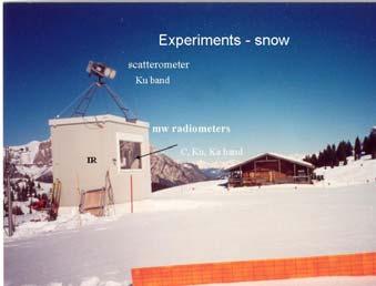

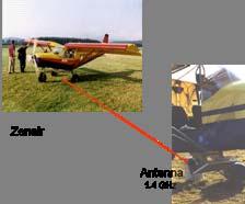


3 Experimental equipments Dome-C Antarctica


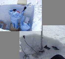

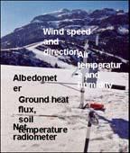
4 Ground measurements
5 Experimental results: sensitivity to land features
6 TnH 1 0,95 0,9 0,85 0,8 0,75 0,7 0,65 0,6 0,55 0,5 Emissivity spectra of land surfaces FREQUENCY WHEAT CORN ALFALFA SUNFL BS (wet) BS (dry) SNOW (wet) SNOW (dry) FOREST Emissivity spectra of forests (poplar)


7 Emissivity of agricultural surfaces TnH Ka band X band L-band Soil moisture Smooth bare SMCg (%) X band L-band TnH Km Rough slightly vegetated SMCg (%)


8 Sensitivity to Plant Water Content of crops emissivity Broad leaf L X Ka Small leaf

 NDVI")
9 NDVI from SPOT4 Sensitivity to vegetation (AMSR-E) NDVI from AMSR-E
 Snow Depth (cm) 0 15 30 45 60 75 270 250 230")

10 Sensitivity to snow cover: dry snow accumulation Brightness Temperature (K) Snow Depth (cm) TbV meas 10GHz TbV DMRT 10GHz 170 TbV meas 37GHz TbV DMRT 37GHz Snow Water Equivalent (mm)


11 Sensitivity to snow wetness TB (37 GHz) V H T b [K] Melt-refreezing cycles W % Liquid water content
 FI 100 90 80 70")
")
12 Sensitivity to snow cover (AMSR-E) FI Snow Depth (cm) 12/2006

13 Antarctica: Temporal variability L-band Ground based 2 week Time stability Mean = K Dev. st. = 0.18 K

14 Antarctica: Spatial variability AMSR-E (Tb 37 GHz V - Yearly average)
15 220 Antarctica: Temporal variability AMSR-E AMSR-E Brightness Temperature [K] C X Ku Ka Tsnow Retrieved [ C] cm 160 Jan-05 Apr-05 Jul-05 Oct-05 Jan-06 Apr-06 Jul-06 Oct-06 Jan-07 Date Tsnow Measured [ C] Snow Temperature [ C] Snow temp. -80 Jan-05 Apr-05 Jul-05 Oct-05 Jan-06 Apr-06 Jul-06 Oct-06 Jan-07 Date Tsnow Retrieved [ C] cm Tsnow Measured [ C]
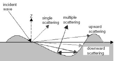
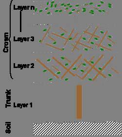
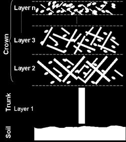


16 Electromagnetc modelling Surface scattering: soil Volume scattering: snow vegetation crops forests
17 Sensitivity to forest biomass Emissivity Forest - Radiative Transfer ( L-Band) Trunk Total Crown Soil Incidence Angle (degs) e v eh ev eh Emissivity Data Disc. Model Cont. Model Woody Volume (m 3 /ha)
18 Model sensitivity to soil roughness V H V H ε = 7 j2 θ = 55 ε = 20 j 5 θ = 55


19 Model sensitivity to snow parameters Snow depth Grain size Snow density
20 Conclusions Microwave emissivity of land surfaces in the frequency range 1-40 GHz strongly depends on Frequency, polarization and incidence agle of the observing sensor Cover type and physical conditions Bare soil: moisture, surface roughness Vegetation: crop/forest type, biomass Snow: depth, density (water equivalent), wetness, grain dimension
Multi- Sensor Ground- based Microwave Snow Experiment at Altay, CHINA
 Multi- Sensor Ground- based Microwave Snow Experiment at Altay, CHINA Jiancheng Shi 1, Chuan Xiong 1, Jinmei Pan 1, Tao Che 2, Tianjie Zhao 1, Haokui Xu 1, Lu Hu 1, Xiang Ji 1, Shunli Chang 3, Suhong Liu
RETRIEVAL OF SOIL MOISTURE OVER SOUTH AMERICA DERIVED FROM MICROWAVE OBSERVATIONS
 2nd Workshop on Remote Sensing and Modeling of Surface Properties 9-11 June 2009, Toulouse, France Météo France Centre International de Conférences RETRIEVAL OF SOIL MOISTURE OVER SOUTH AMERICA DERIVED
Advancing Remote-Sensing Methods for Monitoring Geophysical Parameters
 Advancing Remote-Sensing Methods for Monitoring Geophysical Parameters Christian Mätzler (Retired from University of Bern) Now consultant for Gamma Remote Sensing, Switzerland matzler@iap.unibe.ch TERENO
Microwave Remote Sensing of Soil Moisture. Y.S. Rao CSRE, IIT, Bombay
 Microwave Remote Sensing of Soil Moisture Y.S. Rao CSRE, IIT, Bombay Soil Moisture (SM) Agriculture Hydrology Meteorology Measurement Techniques Survey of methods for soil moisture determination, Water
A New Microwave Snow Emissivity Model
 A New Microwave Snow Emissivity Model Fuzhong Weng 1,2 1. Joint Center for Satellite Data Assimilation 2. NOAA/NESDIS/Office of Research and Applications Banghua Yan DSTI. Inc The 13 th International TOVS
The DMRT-ML model: numerical simulations of the microwave emission of snowpacks based on the Dense Media Radiative Transfer theory
 The DMRT-ML model: numerical simulations of the microwave emission of snowpacks based on the Dense Media Radiative Transfer theory Ludovic Brucker 1,2, Ghislain Picard 3 Alexandre Roy 4, Florent Dupont
Soil Moisture Prediction and Assimilation
 Soil Moisture Prediction and Assimilation Analysis and Prediction in Agricultural Landscapes Saskatoon, June 19-20, 2007 STEPHANE BELAIR Meteorological Research Division Prediction and Assimilation Atmospheric
Passive Microwave Physics & Basics. Edward Kim NASA/GSFC
 Passive Microwave Physics & Basics Edward Kim NASA/GSFC ed.kim@nasa.gov NASA Snow Remote Sensing Workshop, Boulder CO, Aug 14 16, 2013 1 Contents How does passive microwave sensing of snow work? What are
Modeling microwave emission in Antarctica. influence of the snow grain size
 Modeling microwave emission at 9 and 37 GHz in Antarctica : influence of the snow grain size Ludovic Brucker, Ghislain Picard and Michel Fily Laboratoire de Glaciologie et Géophysique de l Environnement
Effect of Antireflective Surface at the Radiobrightness Observations for the Topsoil Covered with Coniferous Litter
 966 PIERS Proceedings, Moscow, Russia, August 18 21, 2009 Effect of Antireflective Surface at the Radiobrightness Observations for the Topsoil Covered with Coniferous Litter V. L. Mironov 1, P. P. Bobrov
Many of remote sensing techniques are generic in nature and may be applied to a variety of vegetated landscapes, including
 Remote Sensing of Vegetation Many of remote sensing techniques are generic in nature and may be applied to a variety of vegetated landscapes, including 1. Agriculture 2. Forest 3. Rangeland 4. Wetland,
CMEM: Community Microwave Emission Model
 CMEM: Community Microwave Emission Model SMOS forward operator for Numerical Weather Prediction P. de Rosnay, M. Drusch, J.-P. Wigneron T. Holmes, G. Balsamo, Y. Kerr, J.-C. Calvet SMOS Workshop 29-31
Assimilation of satellite derived soil moisture for weather forecasting
 Assimilation of satellite derived soil moisture for weather forecasting www.cawcr.gov.au Imtiaz Dharssi and Peter Steinle February 2011 SMOS/SMAP workshop, Monash University Summary In preparation of the
GCOM-W1 now on the A-Train
 GCOM-W1 now on the A-Train GCOM-W1 Global Change Observation Mission-Water Taikan Oki, K. Imaoka, and M. Kachi JAXA/EORC (& IIS/The University of Tokyo) Mini-Workshop on A-Train Science, March 8 th, 2013
SIMULATION OF SPACEBORNE MICROWAVE RADIOMETER MEASUREMENTS OF SNOW COVER FROM IN-SITU DATA AND EMISSION MODELS
 SIMULATION OF SPACEBORNE MICROWAVE RADIOMETER MEASUREMENTS OF SNOW COVER FROM IN-SITU DATA AND EMISSION MODELS Anna Kontu 1 and Jouni Pulliainen 1 1. Finnish Meteorological Institute, Arctic Research,
Astronaut Ellison Shoji Onizuka Memorial Downtown Los Angeles, CA. Los Angeles City Hall
 Astronaut Ellison Shoji Onizuka Memorial Downtown Los Angeles, CA Los Angeles City Hall Passive Microwave Radiometric Observations over Land The performance of physically based precipitation retrievals
Evaluation of sub-kilometric numerical simulations of C-band radar backscatter over the french Alps against Sentinel-1 observations
 Evaluation of sub-kilometric numerical simulations of C-band radar backscatter over the french Alps against Sentinel-1 observations Gaëlle Veyssière, Fatima Karbou, Samuel Morin, Matthieu Lafaysse Monterey,
Estimates of surface soil moisture under wet grass using L-band radiometry:
 Estimates of surface soil moisture under wet grass using L-band radiometry: KAUZAR SALEH, JEAN-PIERRE WIGNERON, PATRICIA DE ROSNAY, JEAN-CHRISTOPHE CALVET, YANN KERR, MARIA J ESCORIHUELA, PHILIPPE WALDTEUFEL
Snow property extraction based on polarimetry and differential SAR interferometry
 Snow property extraction based on polarimetry and differential SAR interferometry S. Leinß, I. Hajnsek Earth Observation and Remote Sensing, Institute of Enviromental Science, ETH Zürich TerraSAR X and
Improved parameterization of the emissivity of soil surfaces and forests at L-band (L-MEB in the Level-2 SMOS algorithm)
") Improved parameterization of the emissivity of soil surfaces and forests at L-band (L-MEB in the Level-2 SMOS algorithm) J-P Wigneron, A. Mialon, J. Grant, Y. Kerr, J-C Calvet, M. Crapeau, F. Demontoux,
Improved parameterization of the emissivity of soil surfaces and forests at L-band (L-MEB in the Level-2 SMOS algorithm) J-P Wigneron, A. Mialon, J. Grant, Y. Kerr, J-C Calvet, M. Crapeau, F. Demontoux,
Assimilation of ASCAT soil wetness
 EWGLAM, October 2010 Assimilation of ASCAT soil wetness Bruce Macpherson, on behalf of Imtiaz Dharssi, Keir Bovis and Clive Jones Contents This presentation covers the following areas ASCAT soil wetness
RADAR Remote Sensing Application Examples
 RADAR Remote Sensing Application Examples! All-weather capability: Microwave penetrates clouds! Construction of short-interval time series through cloud cover - crop-growth cycle! Roughness - Land cover,
ECMWF. ECMWF Land Surface Analysis: Current status and developments. P. de Rosnay M. Drusch, K. Scipal, D. Vasiljevic G. Balsamo, J.
 Land Surface Analysis: Current status and developments P. de Rosnay M. Drusch, K. Scipal, D. Vasiljevic G. Balsamo, J. Muñoz Sabater 2 nd Workshop on Remote Sensing and Modeling of Surface Properties,
Meteorological Satellite Image Interpretations, Part III. Acknowledgement: Dr. S. Kidder at Colorado State Univ.
 Meteorological Satellite Image Interpretations, Part III Acknowledgement: Dr. S. Kidder at Colorado State Univ. Dates EAS417 Topics Jan 30 Introduction & Matlab tutorial Feb 1 Satellite orbits & navigation
GEOGG141 Principles & Practice of Remote Sensing (PPRS) RADAR III: Applications Revision
 RADAR III: Applications Revision") UCL DEPARTMENT OF GEOGRAPHY GEOGG141 Principles & Practice of Remote Sensing (PPRS) RADAR III: Applications Revision Dr. Mathias (Mat) Disney UCL Geography Office: 113, Pearson Building Tel: 7670 0592
UCL DEPARTMENT OF GEOGRAPHY GEOGG141 Principles & Practice of Remote Sensing (PPRS) RADAR III: Applications Revision Dr. Mathias (Mat) Disney UCL Geography Office: 113, Pearson Building Tel: 7670 0592
SOIL MOISTURE EXPERIMENTS 2005 (SMEX05): PASSIVE MICROWAVE POLARIMETRIC SIGNATURES OF SOIL MOISTURE AND VEGETATION
: PASSIVE MICROWAVE POLARIMETRIC SIGNATURES OF SOIL MOISTURE AND VEGETATION") SOIL MOISTURE EXPERIMENTS 25 (SMEX5): PASSIVE MICROWAVE POLARIMETRIC SIGNATURES OF SOIL MOISTURE AND VEGETATION Jackson, T. a, Bindlish, R.a, Du, J. a, Cosh, M. a Li, L b, Gaiser, P b, Kabela, E. c, and
SOIL MOISTURE EXPERIMENTS 25 (SMEX5): PASSIVE MICROWAVE POLARIMETRIC SIGNATURES OF SOIL MOISTURE AND VEGETATION Jackson, T. a, Bindlish, R.a, Du, J. a, Cosh, M. a Li, L b, Gaiser, P b, Kabela, E. c, and
The GCOM- W1 AMSR2 snow depth and snow water equivalent product: update
 The GCOM- W1 AMSR2 snow depth and snow water equivalent product: update Richard Kelly, Nastaran Saberi & Qinghuan Li Department of Geography and Environmental Management University of Waterloo, Waterloo,
Climate Roles of Land Surface
 Lecture 5: Land Surface and Cryosphere (Outline) Climate Roles Surface Energy Balance Surface Water Balance Sea Ice Land Ice (from Our Changing Planet) Surface Albedo Climate Roles of Land Surface greenhouse
Aquarius/SAC-D Soil Moisture Product using V3.0 Observations
 Aquarius/SAC-D Soil Moisture Product using V3. Observations R. Bindlish, T. Jackson, M. Cosh November 214 Overview Soil moisture algorithm Soil moisture product Validation Linkage between Soil Moisture
The role of soil moisture in influencing climate and terrestrial ecosystem processes
 1of 18 The role of soil moisture in influencing climate and terrestrial ecosystem processes Vivek Arora Canadian Centre for Climate Modelling and Analysis Meteorological Service of Canada Outline 2of 18
ECMWF. ECMWF Land Surface modelling and land surface analysis. P. de Rosnay G. Balsamo S. Boussetta, J. Munoz Sabater D.
 Land Surface modelling and land surface analysis P. de Rosnay G. Balsamo S. Boussetta, J. Munoz Sabater D. Vasiljevic M. Drusch, K. Scipal SRNWP 12 June 2009 Slide 1 Surface modelling (G. Balsamo) HTESSEL,
Light Up Your World Adapted from Reflecting on Reflectivity,
 Climate Change I m Supposed To Know What That Is? Light Up Your World Adapted from Reflecting on Reflectivity, http://www.climatechangenorth.ca Overview: Students often confuse global warming and the depletion
ANALYSIS OF LEAF AREA INDEX AND SOIL WATER CONTENT RETRIEVAL FROM AGRISAR DATA SETS
 ANALYSIS OF LEAF AREA INDEX AND SOIL WATER CONTENT RETRIEVAL FROM AGRISAR DATA SETS D'Urso, G. () ; Dini, L. () ; Richter, K. () ; Palladino M. () () DIIAT, Faculty of Agraria, University of Naples Federico
CHAPTER-7 INTERFEROMETRIC ANALYSIS OF SPACEBORNE ENVISAT-ASAR DATA FOR VEGETATION CLASSIFICATION
 147 CHAPTER-7 INTERFEROMETRIC ANALYSIS OF SPACEBORNE ENVISAT-ASAR DATA FOR VEGETATION CLASSIFICATION 7.1 INTRODUCTION: Interferometric synthetic aperture radar (InSAR) is a rapidly evolving SAR remote
Global SWE Mapping by Combining Passive and Active Microwave Data: The GlobSnow Approach and CoReH 2 O
 Global SWE Mapping by Combining Passive and Active Microwave Data: The GlobSnow Approach and CoReH 2 O April 28, 2010 J. Pulliainen, J. Lemmetyinen, A. Kontu, M. Takala, K. Luojus, K. Rautiainen, A.N.
ANALYSIS OF MICROWAVE EMISSION OF EXPONEN- TIALLY CORRELATED ROUGH SOIL SURFACES FROM 1.4 GHz TO 36.5 GHz
 Progress In Electromagnetics Research, Vol. 18, 25 219, 21 ANALYSIS OF MICROWAVE EMISSION OF EXPONEN- TIALLY CORRELATED ROUGH SOIL SURFACES FROM 1.4 GHz TO 36.5 GHz P. Xu and K.-S. Chen Communication Research
Remote Sensing of SWE in Canada
 Remote Sensing of SWE in Canada Anne Walker Climate Research Division, Environment Canada Polar Snowfall Hydrology Mission Workshop, June 26-28, 2007 Satellite Remote Sensing Snow Cover Optical -- Snow
Central Asia Regional Flash Flood Guidance System 4-6 October Hydrologic Research Center A Nonprofit, Public-Benefit Corporation
 http://www.hrcwater.org Central Asia Regional Flash Flood Guidance System 4-6 October 2016 Hydrologic Research Center A Nonprofit, Public-Benefit Corporation FFGS Snow Components Snow Accumulation and
Comparison of NASA AIRS and MODIS Land Surface Temperature and Infrared Emissivity Measurements from the EOS AQUA platform
 Comparison of NASA AIRS and MODIS Land Surface Temperature and Infrared Emissivity Measurements from the EOS AQUA platform Robert Knuteson, Steve Ackerman, Hank Revercomb, Dave Tobin University of Wisconsin-Madison
Agricultural land-use from space. David Pairman and Heather North
 Agricultural land-use from space David Pairman and Heather North Talk Outline Motivation Challenges Different approach Paddock boundaries Classifications Examples Accuracy Issues Data sources Future possibilities
Spectral reflectance: When the solar radiation is incident upon the earth s surface, it is either
 Spectral reflectance: When the solar radiation is incident upon the earth s surface, it is either reflected by the surface, transmitted into the surface or absorbed and emitted by the surface. Remote sensing
Copernicus Global Land Service
 Copernicus Global Land Service Cryosphere Products Kari Luojus on behalf the consortium Follow us on: Copernicus EU CopernicusEU www.copernicus.eu Copernicus Services Land Marine Atmosphere Emergency Security
School on Modelling Tools and Capacity Building in Climate and Public Health April Remote Sensing
 2453-5 School on Modelling Tools and Capacity Building in Climate and Public Health 15-26 April 2013 Remote Sensing CECCATO Pietro International Research Institute for Climate and Society, IRI The Earth
CHARACTERISTICS OF SNOW AND ICE MORPHOLOGICAL FEATURES DERIVED FROM MULTI-POLARIZATION TERRASAR-X DATA
 CHARACTERISTICS OF SNOW AND ICE MORPHOLOGICAL FEATURES DERIVED FROM MULTI-POLARIZATION TERRASAR-X DATA Dana Floricioiu 1, Helmut Rott 2, Thomas Nagler 2, Markus Heidinger 2 and Michael Eineder 1 1 DLR,
Retrieval of Surface Properties Based on Microwave Emissivity Spectra
 Retrieval of Surface Properties Based on Microwave Emissivity Spectra S-A. Boukabara, W. Chen, C. Kongoli, C. Grassotti and K. Garrett NOAA/NESDIS/STAR & JCSDA Camp Springs, Maryland, USA 2nd Workshop
EMPIRICAL ESTIMATION OF VEGETATION PARAMETERS USING MULTISENSOR DATA FUSION
 EMPIRICAL ESTIMATION OF VEGETATION PARAMETERS USING MULTISENSOR DATA FUSION Franz KURZ and Olaf HELLWICH Chair for Photogrammetry and Remote Sensing Technische Universität München, D-80290 Munich, Germany
An experimental study of angular variations of brightness surface temperature for some natural surfaces
 An experimental study of angular variations of brightness surface temperature for some natural surfaces Juan Cuenca, José A. Sobrino, and Guillem Soria University of Valencia, c./ Dr. Moliner 5, 46 Burjassot,
THE ROLE OF MICROSTRUCTURE IN FORWARD MODELING AND DATA ASSIMILATION SCHEMES: A CASE STUDY IN THE KERN RIVER, SIERRA NEVADA, USA
 MICHAEL DURAND (DURAND.8@OSU.EDU), DONGYUE LI, STEVE MARGULIS Photo: Danielle Perrot THE ROLE OF MICROSTRUCTURE IN FORWARD MODELING AND DATA ASSIMILATION SCHEMES: A CASE STUDY IN THE KERN RIVER, SIERRA
GLOBAL LAND COVER CLASSIFICATION BASED ON MICROWAVE POLARIZATION AND GRADIENT RATIO (MPGR)
") GLOBAL LAND COVER CLASSIFICATION BASED ON MICROWAVE POLARIZATION AND GRADIENT RATIO (MPGR) Mukesh, BOORI 1, Ralph, FERRARO 2 1 National Research Council (NRC) USA: Visiting Scientist 2 NOAA/NESDIS/STAR/
GLOBAL LAND COVER CLASSIFICATION BASED ON MICROWAVE POLARIZATION AND GRADIENT RATIO (MPGR) Mukesh, BOORI 1, Ralph, FERRARO 2 1 National Research Council (NRC) USA: Visiting Scientist 2 NOAA/NESDIS/STAR/
Toward a better modeling of surface emissivity to improve AMSU data assimilation over Antarctica GUEDJ Stephanie, KARBOU Fatima and RABIER Florence
 Toward a better modeling of surface emissivity to improve AMSU data assimilation over Antarctica GUEDJ Stephanie, KARBOU Fatima and RABIER Florence International TOVS Study Conference, Monterey, California
Assimilating terrestrial remote sensing data into carbon models: Some issues
 University of Oklahoma Oct. 22-24, 2007 Assimilating terrestrial remote sensing data into carbon models: Some issues Shunlin Liang Department of Geography University of Maryland at College Park, USA Sliang@geog.umd.edu,
Description of Snow Depth Retrieval Algorithm for ADEOS II AMSR
 1. Introduction Description of Snow Depth Retrieval Algorithm for ADEOS II AMSR Dr. Alfred Chang and Dr. Richard Kelly NASA/GSFC The development of a snow depth retrieval algorithm for ADEOS II AMSR has
Field Emissivity Measurements during the ReSeDA Experiment
 Field Emissivity Measurements during the ReSeDA Experiment C. Coll, V. Caselles, E. Rubio, E. Valor and F. Sospedra Department of Thermodynamics, Faculty of Physics, University of Valencia, C/ Dr. Moliner
Lecture 3A: Interception
 3-1 GEOG415 Lecture 3A: Interception What is interception? Canopy interception (C) Litter interception (L) Interception ( I = C + L ) Precipitation (P) Throughfall (T) Stemflow (S) Net precipitation (R)
SNOW cover is the major component of the cryosphere
 IEEE GEOSCIENCE AND REMOTE SENSING LETTERS, VOL. 10, NO. 1, JANUARY 2013 9 The Potential of COSMO-SkyMed SAR Images in Monitoring Snow Cover Characteristics S. Pettinato, Member, IEEE, E. Santi, Member,
METR 130: Lecture 2 - Surface Energy Balance - Surface Moisture Balance. Spring Semester 2011 February 8, 10 & 14, 2011
 METR 130: Lecture 2 - Surface Energy Balance - Surface Moisture Balance Spring Semester 2011 February 8, 10 & 14, 2011 Reading Arya, Chapters 2 through 4 Surface Energy Fluxes (Ch2) Radiative Fluxes (Ch3)
+SOI Neutral SOI -SOI. Melt+ Melt- Melt+ Melt- Melt+ Melt- +SAM 1 (0.76) 6 (3.02) 1 (1.13) 5 (4.92) 1 (2.27) 0 (1.89) 14
 6 (3.02) 1 (1.13) 5 (4.92) 1 (2.27) 0 (1.89) 14") Supplementary Table 1. Contingency table tallying the respective counts of positive and negative surface melt index anomalies in the Ross sector as a function of the signs of the Southern Annular Mode
Supplementary Table 1. Contingency table tallying the respective counts of positive and negative surface melt index anomalies in the Ross sector as a function of the signs of the Southern Annular Mode
Microwave Remote Sensing of Sea Ice
 Microwave Remote Sensing of Sea Ice What is Sea Ice? Passive Microwave Remote Sensing of Sea Ice Basics Sea Ice Concentration Active Microwave Remote Sensing of Sea Ice Basics Sea Ice Type Sea Ice Motion
Land Surface Remote Sensing II
 PROCEEDINGS OFSPIE Land Surface Remote Sensing II Thomas J. Jackson Jing Ming Chen Peng Gong Shunlin Liang Editors 13-16 October 2014 Beijing, China Sponsored by SPIE Cosponsored by State Key Laboratory
SNOW DEPTH AND SURFACE CONDITIONS OF AUSTFONNA ICE CAP (SVALBARD) USING FIELD OBSERVATIONS AND SATELLITE ALTIMETRY
 USING FIELD OBSERVATIONS AND SATELLITE ALTIMETRY") SNOW DEPTH AND SURFACE CONDITIONS OF AUSTFONNA ICE CAP (SVALBARD) USING FIELD OBSERVATIONS AND SATELLITE ALTIMETRY Alexei Kouraev (1,2), Benoît Legrésy (1), Frédérique Rémy (1), Andrea Taurisano (3,4),
SNOW DEPTH AND SURFACE CONDITIONS OF AUSTFONNA ICE CAP (SVALBARD) USING FIELD OBSERVATIONS AND SATELLITE ALTIMETRY Alexei Kouraev (1,2), Benoît Legrésy (1), Frédérique Rémy (1), Andrea Taurisano (3,4),
A Microwave Snow Emissivity Model
 A Microwave Snow Emissivity Model Fuzhong Weng Joint Center for Satellite Data Assimilation NOAA/NESDIS/Office of Research and Applications, Camp Springs, Maryland and Banghua Yan Decision Systems Technologies
F O U N D A T I O N A L C O U R S E
 F O U N D A T I O N A L C O U R S E December 6, 2018 Satellite Foundational Course for JPSS (SatFC-J) F O U N D A T I O N A L C O U R S E Introduction to Microwave Remote Sensing (with a focus on passive
Soil frost from microwave data. Kimmo Rautiainen, Jouni Pulliainen, Juha Lemmetyinen, Jaakko Ikonen, Mika Aurela
 Soil frost from microwave data Kimmo Rautiainen, Jouni Pulliainen, Juha Lemmetyinen, Jaakko Ikonen, Mika Aurela Why landscape freeze/thaw? Latitudinal variation in mean correlations (r) between annual
Fractional Vegetation Cover Estimation from PROBA/CHRIS Data: Methods, Analysis of Angular Effects and Application to the Land Surface Emissivity
 Fractional Vegetation Cover Estimation from PROBA/CHRIS Data: Methods, Analysis of Angular Effects and Application to the Land Surface Emissivity J.C. Jiménez-Muñoz 1, J.A. Sobrino 1, L. Guanter 2, J.
Lecture 19: Operational Remote Sensing in Visible, IR, and Microwave Channels
 MET 4994 Remote Sensing: Radar and Satellite Meteorology MET 5994 Remote Sensing in Meteorology Lecture 19: Operational Remote Sensing in Visible, IR, and Microwave Channels Before you use data from any
Lecture Topics. 1. Vegetation Indices 2. Global NDVI data sets 3. Analysis of temporal NDVI trends
 Lecture Topics 1. Vegetation Indices 2. Global NDVI data sets 3. Analysis of temporal NDVI trends Why use NDVI? Normalize external effects of sun angle, viewing angle, and atmospheric effects Normalize
Remote sensing with FAAM to evaluate model performance
 Remote sensing with FAAM to evaluate model performance YOPP-UK Workshop Chawn Harlow, Exeter 10 November 2015 Contents This presentation covers the following areas Introduce myself Focus of radiation research
Global Biogeography. Natural Vegetation. Structure and Life-Forms of Plants. Terrestrial Ecosystems-The Biomes
 Global Biogeography Natural Vegetation Structure and Life-Forms of Plants Terrestrial Ecosystems-The Biomes Natural Vegetation natural vegetation is the plant cover that develops with little or no human
URSI-F Microwave Signatures Meeting 2010, Florence, Italy, October 4 8, Thomas Meissner Lucrezia Ricciardulli Frank Wentz
 URSI-F Microwave Signatures Meeting 2010, Florence, Italy, October 4 8, 2010 Wind Measurements from Active and Passive Microwave Sensors High Winds and Winds in Rain Thomas Meissner Lucrezia Ricciardulli
The Canadian Land Data Assimilation System (CaLDAS)
") The Canadian Land Data Assimilation System (CaLDAS) Marco L. Carrera, Stéphane Bélair, Bernard Bilodeau and Sheena Solomon Meteorological Research Division, Environment Canada Dorval, QC, Canada 2 nd Workshop
The Canadian Land Data Assimilation System (CaLDAS) Marco L. Carrera, Stéphane Bélair, Bernard Bilodeau and Sheena Solomon Meteorological Research Division, Environment Canada Dorval, QC, Canada 2 nd Workshop
Lambertian surface scattering at AMSU-B frequencies:
 Lambertian surface scattering at AMSU-B frequencies: An analysis of airborne microwave data measured over snowcovered surfaces Chawn Harlow, 2nd Workshop on Remote Sensing and Modeling of Land Surface
Remote sensing of sea ice
 Remote sensing of sea ice Ice concentration/extent Age/type Drift Melting Thickness Christian Haas Remote Sensing Methods Passive: senses shortwave (visible), thermal (infrared) or microwave radiation
Global Climates. Name Date
 Global Climates Name Date No investigation of the atmosphere is complete without examining the global distribution of the major atmospheric elements and the impact that humans have on weather and climate.
Comparison of NASA AIRS and MODIS Land Surface Temperature and Infrared Emissivity Measurements from the EOS AQUA platform
 Comparison of NASA AIRS and MODIS Land Surface Temperature and Infrared Emissivity Measurements from the EOS AQUA platform Robert Knuteson, Hank Revercomb, Dave Tobin University of Wisconsin-Madison 16
C. Jimenez, C. Prigent, F. Aires, S. Ermida. Estellus, Paris, France Observatoire de Paris, France IPMA, Lisbon, Portugal
 All-weather land surface temperature estimates from microwave satellite observations, over several decades and real time: methodology and comparison with infrared estimates C. Jimenez, C. Prigent, F. Aires,
Summary of the World s Major Terrestrial Biomes
 Summary of the World s Major Terrestrial Biomes Tropical Rainforests Precipitation Pattern: High yearly rainfall >100, generally during a long wet season and a short dry season. Temperature/Growing Season:
SEA ICE MICROWAVE EMISSION MODELLING APPLICATIONS
 SEA ICE MICROWAVE EMISSION MODELLING APPLICATIONS R. T. Tonboe, S. Andersen, R. S. Gill Danish Meteorological Institute, Lyngbyvej 100, DK-2100 Copenhagen Ø, Denmark Tel.:+45 39 15 73 49, e-mail: rtt@dmi.dk
Comparison of Wind Speed, Soil Moisture, and Cloud Cover to Relative Humidity to Verify Dew Formation
 Meteorology Senior Theses Undergraduate Theses and Capstone Projects 12-1-2017 Comparison of Wind Speed, Soil Moisture, and Cloud Cover to Relative Humidity to Verify Dew Formation Kelly M. Haberichter
September 2018 Weather Summary West Central Research and Outreach Center Morris, MN
 September 2018 Weather Summary The mean temperature for September was 60.6 F, which is 1.5 F above the average of 59.1 F (1886-2017). The high temperature for the month was 94 F on September 16 th. The
Airborne Measurements of Forest and Agricultural Land Surface Emissivity at Millimeter Wavelengths
 IEEE TRANSACTIONS ON GEOSCIENCE AND REMOTE SENSING, VOL. 39, NO. 2, FEBRUARY 2001 393 Airborne Measurements of Forest and Agricultural Land Surface Emissivity at Millimeter Wavelengths Tim J. Hewison,
Modelling and Validation of Combined Active and Passive Microwave Remote Sensing of Agricultural Vegetation at L-Band
 Progress In Electromagnetics Research B, Vol. 78, 91 124, 2017 Modelling and Validation of Combined Active and Passive Microwave Remote Sensing of Agricultural Vegetation at L-Band Huanting Huang 1, *,
Interdisciplinary research for carbon cycling in a forest ecosystem and scaling to a mountainous landscape in Takayama,, central Japan.
 Asia-Pacific Workshop on Carbon Cycle Observations (March 17 19, 2008) Interdisciplinary research for carbon cycling in a forest ecosystem and scaling to a mountainous landscape in Takayama,, central Japan.
L-Band Radiometry Experiments with ELBARA
 L-Band Radiometry Experiments wit ELBARA 1. ELBARA, te ETH L-band radiometer for soil moisture researc. Bare-Soil Experiment 3. Frozen-Soil Experiment 4. Clover-Grass Experiment 5. Forest Experiment 6.
ASimultaneousRadiometricand Gravimetric Framework
 Towards Multisensor Snow Assimilation: ASimultaneousRadiometricand Gravimetric Framework Assistant Professor, University of Maryland Department of Civil and Environmental Engineering September 8 th, 2014
Soil moisture retrieval over periodic surfaces using PolSAR data
 Soil moisture retrieval over periodic surfaces using PolSAR data Sandrine DANIEL Sophie ALLAIN Laurent FERRO-FAMIL Eric POTTIER IETR Laboratory, UMR CNRS 6164, University of Rennes1, France Contents Soil
Retrieving soil moisture and agricultural variables by microwave radiometry using neural networks
 Remote Sensing of Environment 84 (2003) 174 183 www.elsevier.com/locate/rse Retrieving soil moisture and agricultural variables by microwave radiometry using neural networks F. Del Frate *, P. Ferrazzoli,
Atmospheric Soundings of Temperature, Moisture and Ozone from AIRS
 Atmospheric Soundings of Temperature, Moisture and Ozone from AIRS M.D. Goldberg, W. Wolf, L. Zhou, M. Divakarla,, C.D. Barnet, L. McMillin, NOAA/NESDIS/ORA Oct 31, 2003 Presented at ITSC-13 Risk Reduction
Land Surface Processes and Their Impact in Weather Forecasting
 Land Surface Processes and Their Impact in Weather Forecasting Andrea Hahmann NCAR/RAL with thanks to P. Dirmeyer (COLA) and R. Koster (NASA/GSFC) Forecasters Conference Summer 2005 Andrea Hahmann ATEC
Global Patterns Gaston, K.J Nature 405. Benefit Diversity. Threats to Biodiversity
 Biodiversity Definitions the variability among living organisms from all sources, including, 'inter alia', terrestrial, marine, and other aquatic ecosystems, and the ecological complexes of which they
APPLICATION OF SATELLITE MICROWAVE IMAGES IN ESTIMATING SNOW WATER EQUIVALENT 1
 JOURNAL OF THE AMERICAN WATER RESOURCES ASSOCIATION Vol. 44, No. 6 AMERICAN WATER RESOURCES ASSOCIATION December 2008 APPLICATION OF SATELLITE MICROWAVE IMAGES IN ESTIMATING SNOW WATER EQUIVALENT 1 Amir
Snowfall Detection and Retrieval from Passive Microwave Satellite Observations. Guosheng Liu Florida State University
 Snowfall Detection and Retrieval from Passive Microwave Satellite Observations Guosheng Liu Florida State University Collaborators: Eun Kyoung Seo, Yalei You Snowfall Retrieval: Active vs. Passive CloudSat
Communicating Climate Change Consequences for Land Use
 Communicating Climate Change Consequences for Land Use Site: Prabost, Skye. Event: Kyle of Lochalsh, 28 th February 28 Further information: http://www.macaulay.ac.uk/ladss/comm_cc_consequences.html Who
Measuring and Analyzing of Thermal Infrared Emission Directionality over crop canopies with an airborne wide-angle thermal IR camera.
 Measuring and Analyzing of Thermal Infrared Emission Directionality over crop canopies with an airborne wide-angle thermal IR camera. X. F. Gu 1, F. Jacob 1, J. F. Hanocq 1, T. Yu 1,2, Q. H. Liu 2, L.
Remote Sensing of Snow GEOG 454 / 654
 Remote Sensing of Snow GEOG 454 / 654 What crysopheric questions can RS help to answer? 2 o Where is snow lying? (Snow-covered area or extent) o How much is there? o How rapidly is it melting? (Area, depth,
JRA-55 Product Users Handbook
 Climate Prediction Division Global Environment and Marine Department Japan Meteorological Agency March 2014 Change record Version Date Remarks 1.0 3 March 2014 First version 2 Contents 1. Introduction...
Hyperspectral Observations of Land Surfaces: Temperature & Emissivity
 Hyperspectral Observations of Land Surfaces: Temperature & Emissivity Isabel F. Trigo Contributions from: Frank Göttsche, Filipe Aires, Maxime Paul Outline Land Surface Temperature Products & Requirements
Reflectivity in Remote Sensing
 Reflectivity in Remote Sensing The amount of absorbance and reflection of white light by a substance is dependent upon the molecular makeup of the substance. Humans have used dyes for years to obtain colors-
Interpretation of Polar-orbiting Satellite Observations. Atmospheric Instrumentation
 Interpretation of Polar-orbiting Satellite Observations Outline Polar-Orbiting Observations: Review of Polar-Orbiting Satellite Systems Overview of Currently Active Satellites / Sensors Overview of Sensor
Remote sensing of snow at SYKE Sari Metsämäki
 Remote sensing of snow at SYKE 2011-01-21 Sari Metsämäki Activities in different projects Snow extent product in ESA DUE-project GlobSnow Long term datasets (15-30 years) on Snow Extent (SE) and Snow Water
November 2018 Weather Summary West Central Research and Outreach Center Morris, MN
 November 2018 Weather Summary Lower than normal temperatures occurred for the second month. The mean temperature for November was 22.7 F, which is 7.2 F below the average of 29.9 F (1886-2017). This November