Microwave Remote Sensing of Soil Moisture. Y.S. Rao CSRE, IIT, Bombay
|
|
|
- Osborn Cook
- 6 years ago
- Views:
Transcription
1 Microwave Remote Sensing of Soil Moisture Y.S. Rao CSRE, IIT, Bombay
2 Soil Moisture (SM) Agriculture Hydrology Meteorology
3 Measurement Techniques Survey of methods for soil moisture determination, Water Resources Research, Vol. 16, No.6, Page , 1980, Schmugge et al. (1980) In Situ Methods Gravimetric Nuclear Techniques Electromagnetic Techniques Tensiometric Techniques Hygrometric Techniques
4 Remote Sensing Methods Visible & near IR Reflected Solar Thermal IR Surface Temperature Passive Microwave Microwave Emission/Brightness Temperature Active Microwave Backscattering coefficient/dielectric properties
5 Gravimetric Techniques Oven drying a soil sample at C for about 12 hours. %M wt = W wet W W Volumetric Soil Moisture (gm/cm 3 ) dry dry Y d Oven Dry Bulk Density *100 %M * Y wt d
6
7 Nuclear Techniques Fast neutrons emitted by an Americium 241: Beryllium radioactive source are themalised (slowed) by hydrozen in the test sample Advantages : SM can be measured at the any time, average SM can be measured with depth, system can be interfaced for automatic recording, temporal SM changes can be measured, readings are directly related SM Disadvantages : Surface soil moisture is not accurate, care must be taken to minimize health risks.

8
9 Electromagnetic Techniques The technique is based on the electrical properties of the soil that varies with soil moisture. Resistivity or Capacitance between electrodes in a soil is measured for Soil moisture. Complex Dielectric Constant ε = ε + jε r i

10
11 Tensiometric Techniques Measures the capillary tension or the energy with which water is held (suction) by the soil. Tensiometers consist of porous ceramic cup connected by a continuous liquid column to a vacuum gauge or transducer. Advantages : easy to design, cost little, at any conditions in real time, placed in soil easily, Disadvantages : Only measures soil water suction, but only indirect measurement of soil moisture content; during installation, it may break.
12
13 Soil Water Models SM t = SM t-1 +P-R-L-E-T+C-Q SM t Soil moisture at time t SM t-1 Soil moisture at previous time P Precipitation R Surface Runoff L - net lateral subsurface outflow E Evaporation or condensation T Transpiration USDAHL Model C Capillary rise from lower levels NWSRFS model Q - percolation
14
15 Remote Sensing Methods Visible Technique: Reflected solar energy is measured. ( mm) Relationship between Reflectance and SM Depends on reflectance of dry soil, roughness, colour, illumination, organic matter, soil texture.
16 Thermal Infrared Techniques Diurnal range of Surface Temperature(T max -T min ) or Measurement of crop canopy air temperature differential. (T max -T min ) depends on internal and external factors Internal factors : Thermal conductivity(k) and heat capacity (C ) where P = (KC) 1/2 is known as Thermal Inertia. K and C increases with Soil Moisture. External Factors : solar radiation, air temperature, RH, cloudiness, and wind.
17 Diurnal Temperature Variation versus Soil Moisture
18 MODIS Data from Terra and Aqua Satellites Swath : 2330 Km and covers the same area 1 or 2 days Spectral Bands : 36 ; Wavelength : Resolution : 250m (bands 1-2, 500m (bands 3-7), 1000m(8-36). Surface/Cloud Temperature LANDSAT 7 band-6 ( microns, Resolution 60 m)
19 Microwave Remote Sensing GHz ( wavelength 1 m - 1 mm ) Passive Active (Radiation or T B ) (Backscattering s 0 db ) Radiometers T B = e T Where e is emissivity and T is physical Temperature Radar σ 0 depends on dielectric properties of soil, geometric properties and system parameters.
20 Advantages All weather Capability Day-night ability Penetration through a medium
21 Penetration
22 Passive Microwave Remote Sensing Emitted Radiation in Passive MRS T Bp = T u + e τ a T bp + e τ a R p [ ] τ T + T e... ( d sky a θ
23 Brightness Temperature T B =et e Emissivity, T Physical Temperature Fresnel Reflection Equations T B =et e e h v = 1 R = 1 R v h Cos θ = 1 Cos θ + = 1 ε Cos θ ε Cos θ + ε Sin ε Sin ε Sin ε Sin θ θ θ θ 2 2
24
25 Radiometer Systems and their Parameters Parameters SSMR in NIMBUS-7 SSM/I IRS-P4, MSMR EOS Aqua AMSR-E ADEOS-II AMSR Launch date /92/95 May 26, 1999 May 4, 2002 Jan. 16, 2004 Frequency (GHz.) 6.6, 10.7, 18.0, 21 and 37 GHz 19.3, 22.2 (V), 38.0 and 85.5 GHz Polarization H & V H &V (except 22.2 GHz) 6.6, 10.65, 18, , 10.65, 18.7, 23.8, 36.5, , 10.7, 18.7, 23.8, 36.5, 89, (50.3 V and 52.8 V polarization only ) H&V H&V H&V (except last 2) IFOV (km x km) 148x95, 91x59, 55x41, 46x30, 27x18 Swath width (km) Revisit coverage(days) 69x43, 60x40, 37x28, 15x13 km 150x144, 75x72, 50x36, 50x36 km 76x44, 49x28, 28x16, 31x18, 14x8, 6x4 km 822 km 1400 km day x40,46x27,25x14,2 8x17,14x8,6x3,10x6 km Incidence angle (deg.) 50.3 (at the surface) 53.3 (at the surface) (at the surface) 54 (at the surface) Sensitivity 0.4, 0.5, 0.7, 0.7, , 0.8, 0.6, , 0.75, 1.05, , 0.6, 0.6, 0.6, 0.6, ,0.6,0.6,0.6,0.6,1.0, 1.3,0.9
26 Polarization HH, VV are like polarized HV, VH are cross polarized y y y E E E x x x Linear Elliptical Circular
27 IFOV, Swath, Incidence Angle

28 SSM/I Satellite
29

30

31

32

33 EOS-PM (AQUA-1) Satellite AMSR-E, Launched May 4, 2002

34 Data Available from Feb onwards Frequencies (GHz) 6.6, 10.65, 18.7, 23.8, 36.5, 89 Resolution (km) 76x44, 49x28, 28x16, 31x18, 14x8, 6x4
35 Active Sensor Systems and System Parameters Parameters Seasat ERS-1,2 JERS -1 Radars at SIR-C ENVISAT Radarsat -2 Launch June July 91 &Apr 95 Feb. 92 Nov. 95 Apr & Oct March 1, Frequency ,5.3, Waveleng.,c m ,5.6, Resolution(m ) Swath (km) km Look anlge Polarization HH VV HH HH HH,VV,H V HH,VV HH,VV Looks

36 Elements of a Typical Remote Sensing Radar
37
38

39 ERS-1 Satellite with C-band VV SAR system System Parameters Launch: July 91 & Apr 95 (ERS2) Frequency : 5.3 GHz ( l=5.6 cm) Resolution : 30 m Swath : 100 km Look Angle : 23 0 Polarization: VV Looks : 4
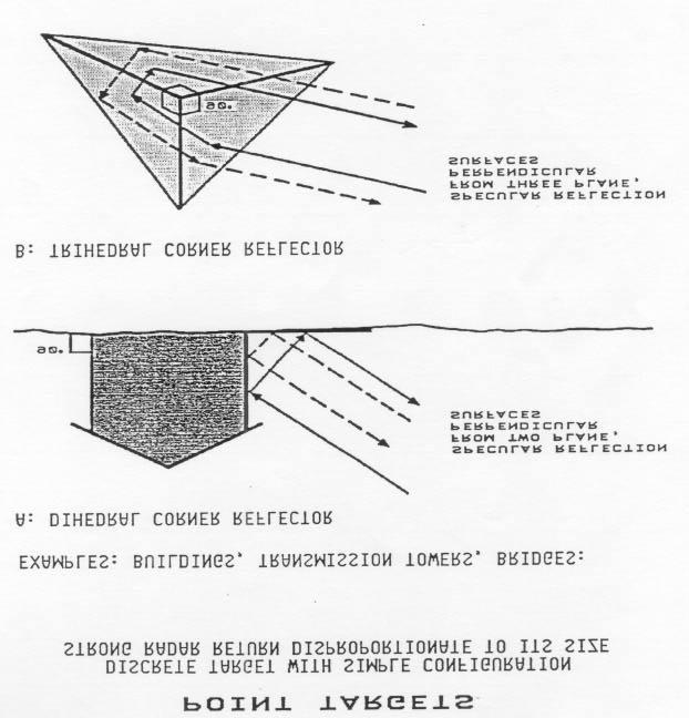
 Resolution:10-100 m Swath : 35-500 km Look Angle: 20-50 0")
40 RADARSAT-I System Parameters Frequency : 5.3 GHz ( l=5.6 cm) Resolution: m Swath : km Look Angle: Polarization : HH Looks : 4 to 14

41 Future SAR Systems ENVISAT (Launch Date : March 1, 2002)

42 ENVISAT ASAR Operating Models

43 First Image from ENVISAT Antarctica Larsen B ice shelf Wide Swath 400 km 150 m resolution March 18, 2002


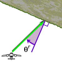
44 Incidence Angle Local incidence angle


45 Slant Range to Ground Range


46 Geometric Effects Foreshortening Layover Shadow

47 Speckle Reflection, Diffuse scattering Corner Reflector Volume Scattering
48 Surface Roughness 1 _ 2 σ= ( ( z) 2 N( z) ) N 1 s X-band C-band L smooth smooth smooth 0.5 rough interm. smooth 1.5 rough rough interm rough rough rough

49
50

51
52

53 Radarsart HH,VV, HV, VH

")
54 Advanced Land Observing Satellite (ALOS) 2004 PALSAR (Phased array SAR) PRISM
55 LightSAR (USA & Germany L- and X-band All Polarizations RISAT (Radar Imaging Satellite) C-band in 3 modes


56 Cryosat Radar Altimeter Mission Determine the variation in the thickness of the Ice sheets to be planned to Launch 2004 Range Resolution 4.6 cm, accuracy 1 or 2 cm

57 Indian RISAT SAR Launch year Frequency = 5.35 GHz Resolution HRS 1-2 m with Swath 10 x 10 km, single/dual polarization FRS-1 mode 3-6 m with swath 30 km, single/dual polarization FRS-2 model 9-12, with swath 30 km, Quad polarization MRS/CRS mode m, with swath 120/240 km, single/quad
Remote sensing of sea ice
 Remote sensing of sea ice Ice concentration/extent Age/type Drift Melting Thickness Christian Haas Remote Sensing Methods Passive: senses shortwave (visible), thermal (infrared) or microwave radiation
RADAR Remote Sensing Application Examples
 RADAR Remote Sensing Application Examples! All-weather capability: Microwave penetrates clouds! Construction of short-interval time series through cloud cover - crop-growth cycle! Roughness - Land cover,
Remote Sensing and GIS. Microwave Remote Sensing and its Applications
 Subject Paper No and Title Module No and Title Module Tag Geology Remote Sensing and GIS Microwave Remote Sensing and its Applications RS & GIS XVII Principal Investigator Co-Principal Investigator Co-Principal
Meteorological Satellite Image Interpretations, Part III. Acknowledgement: Dr. S. Kidder at Colorado State Univ.
 Meteorological Satellite Image Interpretations, Part III Acknowledgement: Dr. S. Kidder at Colorado State Univ. Dates EAS417 Topics Jan 30 Introduction & Matlab tutorial Feb 1 Satellite orbits & navigation
The Importance of Microwave Remote Sensing for Operational Sea Ice Services And Challenges
 The Importance of Microwave Remote Sensing for Operational Sea Ice Services And Challenges Wolfgang Dierking January 2015 (1) Why is microwave remote sensing important (=useful) for sea ice mapping? Problems
GEOGG141 Principles & Practice of Remote Sensing (PPRS) RADAR III: Applications Revision
 RADAR III: Applications Revision") UCL DEPARTMENT OF GEOGRAPHY GEOGG141 Principles & Practice of Remote Sensing (PPRS) RADAR III: Applications Revision Dr. Mathias (Mat) Disney UCL Geography Office: 113, Pearson Building Tel: 7670 0592
UCL DEPARTMENT OF GEOGRAPHY GEOGG141 Principles & Practice of Remote Sensing (PPRS) RADAR III: Applications Revision Dr. Mathias (Mat) Disney UCL Geography Office: 113, Pearson Building Tel: 7670 0592
GEOSC/METEO 597K Kevin Bowley Kaitlin Walsh
 GEOSC/METEO 597K Kevin Bowley Kaitlin Walsh Timeline of Satellites ERS-1 (1991-2000) NSCAT (1996) Envisat (2002) RADARSAT (2007) Seasat (1978) TOPEX/Poseidon (1992-2005) QuikSCAT (1999) Jason-2 (2008)
Remote Sensing I: Basics
 Remote Sensing I: Basics Kelly M. Brunt Earth System Science Interdisciplinary Center, University of Maryland Cryospheric Science Laboratory, Goddard Space Flight Center kelly.m.brunt@nasa.gov (Based on
Microwave emissivity of land surfaces: experiments and models
 Microwave emissivity of land surfaces: experiments and models M. Brogioni, G.Macelloni, S.Paloscia, P.Pampaloni, S.Pettinato, E.Santi IFAC-CNR Florence, Italy Introduction Experimental investigations conducted
Interpretation of Polar-orbiting Satellite Observations. Atmospheric Instrumentation
 Interpretation of Polar-orbiting Satellite Observations Outline Polar-Orbiting Observations: Review of Polar-Orbiting Satellite Systems Overview of Currently Active Satellites / Sensors Overview of Sensor
Assimilation of satellite derived soil moisture for weather forecasting
 Assimilation of satellite derived soil moisture for weather forecasting www.cawcr.gov.au Imtiaz Dharssi and Peter Steinle February 2011 SMOS/SMAP workshop, Monash University Summary In preparation of the
Microwave Remote Sensing of Sea Ice
 Microwave Remote Sensing of Sea Ice What is Sea Ice? Passive Microwave Remote Sensing of Sea Ice Basics Sea Ice Concentration Active Microwave Remote Sensing of Sea Ice Basics Sea Ice Type Sea Ice Motion
Fri. Apr. 06, Map Projections Environmental Applications. Reading: Finish Chapter 9 ( Environmental Remote Sensing )
") Fri. Apr. 06, 2018 Map Projections Environmental Applications Reading: Finish Chapter 9 ( Environmental Remote Sensing ) Once again -- Satellites old but principles still apply Skim Sabins Chapter 10.
Fri. Apr. 06, 2018 Map Projections Environmental Applications Reading: Finish Chapter 9 ( Environmental Remote Sensing ) Once again -- Satellites old but principles still apply Skim Sabins Chapter 10.
PREDICTION AND MONITORING OF OCEANIC DISASTERS USING MICROWAVE REMOTE SENSING TECHNIQUES
 PREDICTION AND MONITORING OF OCEANIC DISASTERS USING MICROWAVE REMOTE SENSING TECHNIQUES O P N Calla International Centre for Radio Science, OM NIWAS A-23, Shastri Nagar, Jodhpur-342 003 Abstract The disasters
Lecture 19: Operational Remote Sensing in Visible, IR, and Microwave Channels
 MET 4994 Remote Sensing: Radar and Satellite Meteorology MET 5994 Remote Sensing in Meteorology Lecture 19: Operational Remote Sensing in Visible, IR, and Microwave Channels Before you use data from any
Assimilation of ASCAT soil wetness
 EWGLAM, October 2010 Assimilation of ASCAT soil wetness Bruce Macpherson, on behalf of Imtiaz Dharssi, Keir Bovis and Clive Jones Contents This presentation covers the following areas ASCAT soil wetness
Remote Sensing of Precipitation
 Lecture Notes Prepared by Prof. J. Francis Spring 2003 Remote Sensing of Precipitation Primary reference: Chapter 9 of KVH I. Motivation -- why do we need to measure precipitation with remote sensing instruments?
REVISION OF THE STATEMENT OF GUIDANCE FOR GLOBAL NUMERICAL WEATHER PREDICTION. (Submitted by Dr. J. Eyre)
") WORLD METEOROLOGICAL ORGANIZATION Distr.: RESTRICTED CBS/OPAG-IOS (ODRRGOS-5)/Doc.5, Add.5 (11.VI.2002) COMMISSION FOR BASIC SYSTEMS OPEN PROGRAMME AREA GROUP ON INTEGRATED OBSERVING SYSTEMS ITEM: 4 EXPERT
WORLD METEOROLOGICAL ORGANIZATION Distr.: RESTRICTED CBS/OPAG-IOS (ODRRGOS-5)/Doc.5, Add.5 (11.VI.2002) COMMISSION FOR BASIC SYSTEMS OPEN PROGRAMME AREA GROUP ON INTEGRATED OBSERVING SYSTEMS ITEM: 4 EXPERT
Linking Different Spatial Scales For Retrieval Of Sea Ice Conditions From SAR Images
 Linking Different Spatial Scales For Retrieval Of Sea Ice Conditions From SAR Images Matt Arkett 2, Wolfgang Dierking 1, Jakob Griebel 1, Thomas Hollands 1, Stefanie Linow 1, Eero Rinne 3, Markku Similä
F O U N D A T I O N A L C O U R S E
 F O U N D A T I O N A L C O U R S E December 6, 2018 Satellite Foundational Course for JPSS (SatFC-J) F O U N D A T I O N A L C O U R S E Introduction to Microwave Remote Sensing (with a focus on passive
Remote Sensing of Snow GEOG 454 / 654
 Remote Sensing of Snow GEOG 454 / 654 What crysopheric questions can RS help to answer? 2 o Where is snow lying? (Snow-covered area or extent) o How much is there? o How rapidly is it melting? (Area, depth,
Multi- Sensor Ground- based Microwave Snow Experiment at Altay, CHINA
 Multi- Sensor Ground- based Microwave Snow Experiment at Altay, CHINA Jiancheng Shi 1, Chuan Xiong 1, Jinmei Pan 1, Tao Che 2, Tianjie Zhao 1, Haokui Xu 1, Lu Hu 1, Xiang Ji 1, Shunli Chang 3, Suhong Liu
Contents Preface xiil Chapter 1 Introduction to Remote Sensing
 Preface xii Chapter 1 Introduction to Remote Sensing 1 1.1 Order of Battle 2 1.1.1 Air order of battle 3 1.1.2 Electronic order of battle 3 1.1.3 Space order of battle 7 1.1.4 Naval order of battle 8 1.2
Prospects of microwave remote sensing for snow hydrology
 Hydrologie Applications of Space Technology (Proceedings of the Cocoa Beach Workshop, Florida, August 1985). IAHS Publ. no. 160,1986. Prospects of microwave remote sensing for snow hydrology HELMUT ROTT
USE OF SATELLITE REMOTE SENSING IN HYDROLOGICAL PREDICTIONS IN UNGAGED BASINS
 USE OF SATELLITE REMOTE SENSING IN HYDROLOGICAL PREDICTIONS IN UNGAGED BASINS Venkat Lakshmi, PhD, P.E. Department of Geological Sciences, University of South Carolina, Columbia SC 29208 (803)-777-3552;
Study of emissivity of dry and wet loamy sand soil at microwave frequencies
 Indian Journal of Radio & Space Physics Vol. 29, June 2, pp. 14-145 Study of emissivity of dry and wet loamy sand soil at microwave frequencies P N Calla Internati onal Centre for Radio Science, "OM NIWAS"
SMAP and SMOS Integrated Soil Moisture Validation. T. J. Jackson USDA ARS
 SMAP and SMOS Integrated Soil Moisture Validation T. J. Jackson USDA ARS Perspective Linkage of SMOS and SMAP soil moisture calibration and validation will have short and long term benefits for both missions.
Advancing Remote-Sensing Methods for Monitoring Geophysical Parameters
 Advancing Remote-Sensing Methods for Monitoring Geophysical Parameters Christian Mätzler (Retired from University of Bern) Now consultant for Gamma Remote Sensing, Switzerland matzler@iap.unibe.ch TERENO
An Ensemble Land Surface Modeling and Assimilation Testbed for HEPEX
 GSFC s Land Data Assimilation Systems: An Ensemble Land Surface Modeling and Assimilation Testbed for HEPEX Christa Peters-Lidard Lidard,, Paul Houser, Matthew Rodell, Brian Cosgrove NASA Goddard Space
GEOG Lecture 8. Orbits, scale and trade-offs
 Environmental Remote Sensing GEOG 2021 Lecture 8 Orbits, scale and trade-offs Orbits revisit Orbits geostationary (36 000 km altitude) polar orbiting (200-1000 km altitude) Orbits revisit Orbits geostationary
Making a case for full-polarimetric radar remote sensing
 Making a case for full-polarimetric radar remote sensing Jeremy Nicoll Alaska Satellite Facility, University of Alaska Fairbanks 1 Polarization States of a Coherent Plane Wave electric field vector vertically
Studying snow cover in European Russia with the use of remote sensing methods
 40 Remote Sensing and GIS for Hydrology and Water Resources (IAHS Publ. 368, 2015) (Proceedings RSHS14 and ICGRHWE14, Guangzhou, China, August 2014). Studying snow cover in European Russia with the use
Earth Exploration-Satellite Service (EESS)- Active Spaceborne Remote Sensing and Operations
- Active Spaceborne Remote Sensing and Operations") Earth Exploration-Satellite Service (EESS)- Active Spaceborne Remote Sensing and Operations SRTM Radarsat JASON Seawinds TRMM Cloudsat Bryan Huneycutt (USA) Charles Wende (USA) WMO, Geneva, Switzerland
Earth Exploration-Satellite Service (EESS)- Active Spaceborne Remote Sensing and Operations SRTM Radarsat JASON Seawinds TRMM Cloudsat Bryan Huneycutt (USA) Charles Wende (USA) WMO, Geneva, Switzerland
School on Modelling Tools and Capacity Building in Climate and Public Health April Remote Sensing
 2453-5 School on Modelling Tools and Capacity Building in Climate and Public Health 15-26 April 2013 Remote Sensing CECCATO Pietro International Research Institute for Climate and Society, IRI The Earth
PASSIVE MICROWAVE IMAGING. Dr. A. Bhattacharya
 1 PASSIVE MICROWAVE IMAGING Dr. A. Bhattacharya 2 Basic Principles of Passive Microwave Imaging Imaging with passive microwave is a complementary technology that needs an introduction to identify its role
RETRIEVAL OF SOIL MOISTURE OVER SOUTH AMERICA DERIVED FROM MICROWAVE OBSERVATIONS
 2nd Workshop on Remote Sensing and Modeling of Surface Properties 9-11 June 2009, Toulouse, France Météo France Centre International de Conférences RETRIEVAL OF SOIL MOISTURE OVER SOUTH AMERICA DERIVED
exp ( κh/ cos θ) whereas as that of the diffuse source is never zero (expect as h ).
 whereas as that of the diffuse source is never zero (expect as h ).") Homework 3: Due Feb 4 1. 2.11 Solution done in class 2. 2.8 The transmissivity along any dection is exp ( κh/ cos θ) where h is the slab thickness and θ is the angle between that dection and the normal
Homework 3: Due Feb 4 1. 2.11 Solution done in class 2. 2.8 The transmissivity along any dection is exp ( κh/ cos θ) where h is the slab thickness and θ is the angle between that dection and the normal
Towards the use of SAR observations from Sentinel-1 to study snowpack properties in Alpine regions
 Towards the use of SAR observations from Sentinel-1 to study snowpack properties in Alpine regions Gaëlle Veyssière, Fatima Karbou, Samuel Morin et Vincent Vionnet CNRM-GAME /Centre d Etude de la Neige
Snow property extraction based on polarimetry and differential SAR interferometry
 Snow property extraction based on polarimetry and differential SAR interferometry S. Leinß, I. Hajnsek Earth Observation and Remote Sensing, Institute of Enviromental Science, ETH Zürich TerraSAR X and
Introduction to SMAP. ARSET Applied Remote Sensing Training. Jul. 20,
 National Aeronautics and Space Administration ARSET Applied Remote Sensing Training http://arset.gsfc.nasa.gov @NASAARSET Introduction to SMAP Jul. 20, 2016 www.nasa.gov Outline 1. Mission objectives 2.
Evaluation of sub-kilometric numerical simulations of C-band radar backscatter over the french Alps against Sentinel-1 observations
 Evaluation of sub-kilometric numerical simulations of C-band radar backscatter over the french Alps against Sentinel-1 observations Gaëlle Veyssière, Fatima Karbou, Samuel Morin, Matthieu Lafaysse Monterey,
Overview of Long- term Observa3ons of the Global Water Cycle by the Advanced Microwave Scanning Radiometer (AMSR) Series
 Series") Overview of Long- term Observa3ons of the Global Water Cycle by the Advanced Microwave Scanning Radiometer (AMSR) Series M. Kachi 1), T. Maeda 1), N. Ono 1), M. Kasahara 1), N. Ebuchi 1),2), and H. Shimoda
Overview of Long- term Observa3ons of the Global Water Cycle by the Advanced Microwave Scanning Radiometer (AMSR) Series M. Kachi 1), T. Maeda 1), N. Ono 1), M. Kasahara 1), N. Ebuchi 1),2), and H. Shimoda
CHAPTER VI EFFECT OF SALINITY ON DIELECTRIC PROPERTIES OF SOILS
 CHAPTER VI EFFECT OF SALINITY ON DIELECTRIC PROPERTIES OF SOILS 6.1 INTRODUCTION: The identification of effect of saline water on soils with their location is useful to both the planner s and farmer s
Reminder: All answers MUST GO ON ANSWER SHEET! Answers recorded in the exam booklet will not count.
 Reminder: All answers MUST GO ON ANSWER SHEET! Answers recorded in the exam booklet will not count. 1. Identify the following acronyms; compare these platform types; provide situations where one platform
DLR s TerraSAR-X contributes to international fleet of radar satellites to map the Arctic and Antarctica
 DLR s TerraSAR-X contributes to international fleet of radar satellites to map the Arctic and Antarctica The polar regions play an important role in the Earth system. The snow and ice covered ocean and
ECMWF. ECMWF Land Surface Analysis: Current status and developments. P. de Rosnay M. Drusch, K. Scipal, D. Vasiljevic G. Balsamo, J.
 Land Surface Analysis: Current status and developments P. de Rosnay M. Drusch, K. Scipal, D. Vasiljevic G. Balsamo, J. Muñoz Sabater 2 nd Workshop on Remote Sensing and Modeling of Surface Properties,
Current developments of remote sensing for mapping and monitoring land degradation at regional scale
 Current developments of remote sensing for mapping and monitoring land degradation at regional scale Prof Graciela Metternicht Chair, ICA Commission on Mapping from Satellite Imagery Curtin University
Japanese Programs on Space and Water Applications
 Japanese Programs on Space and Water Applications Tamotsu IGARASHI Remote Sensing Technology Center of Japan June 2006 COPUOS 2006 Vienna International Centre Water-related hazards/disasters may occur
New observations obtained via applying remote sensing methods in geological hazard assessment, Southern Ethiopia
 New observations obtained via applying remote sensing methods in geological hazard assessment, Southern Ethiopia Veronika Kopačková, Jan Mišurec Remote sensing Unit Czech Geological Survey, Klárov 3, Prague
CHARACTERISTICS OF SNOW AND ICE MORPHOLOGICAL FEATURES DERIVED FROM MULTI-POLARIZATION TERRASAR-X DATA
 CHARACTERISTICS OF SNOW AND ICE MORPHOLOGICAL FEATURES DERIVED FROM MULTI-POLARIZATION TERRASAR-X DATA Dana Floricioiu 1, Helmut Rott 2, Thomas Nagler 2, Markus Heidinger 2 and Michael Eineder 1 1 DLR,
Flux Tower Data Quality Analysis in the North American Monsoon Region
 Flux Tower Data Quality Analysis in the North American Monsoon Region 1. Motivation The area of focus in this study is mainly Arizona, due to data richness and availability. Monsoon rains in Arizona usually
Effect of Antireflective Surface at the Radiobrightness Observations for the Topsoil Covered with Coniferous Litter
 966 PIERS Proceedings, Moscow, Russia, August 18 21, 2009 Effect of Antireflective Surface at the Radiobrightness Observations for the Topsoil Covered with Coniferous Litter V. L. Mironov 1, P. P. Bobrov
Soil Moisture Estimation by Microwave Remote Sensing for Assimilation into WATClass
 Soil Moisture Estimation by Microwave Remote Sensing for Assimilation into WATClass by Damian Chi-Ho Kwok A thesis presented to the University of Waterloo in fulfillment of the thesis requirement for the
Chapter 1: Introduction
 Chapter 1: Introduction Photogrammetry: Definition & applications What are we trying to do? Data acquisition systems 3-D viewing of 2-D imagery Automation (matching problem) Necessary tools: Image formation
Dr. Linlin Ge The University of New South Wales
 GMAT 9600 Principles of Remote Sensing Week2 Electromagnetic Radiation: Definition & Physics Dr. Linlin Ge www.gmat.unsw.edu.au/linlinge Basic radiation quantities Outline Wave and quantum properties Polarization
HY-2A Satellite User s Guide
 National Satellite Ocean Application Service 2013-5-16 Document Change Record Revision Date Changed Pages/Paragraphs Edit Description i Contents 1 Introduction to HY-2 Satellite... 1 2 HY-2 satellite data
Remote Sensing in Meteorology: Satellites and Radar. AT 351 Lab 10 April 2, Remote Sensing
 Remote Sensing in Meteorology: Satellites and Radar AT 351 Lab 10 April 2, 2008 Remote Sensing Remote sensing is gathering information about something without being in physical contact with it typically
CLIMATE CHANGE AND REGIONAL HYDROLOGY ACROSS THE NORTHEAST US: Evidence of Changes, Model Projections, and Remote Sensing Approaches
 CLIMATE CHANGE AND REGIONAL HYDROLOGY ACROSS THE NORTHEAST US: Evidence of Changes, Model Projections, and Remote Sensing Approaches Michael A. Rawlins Dept of Geosciences University of Massachusetts OUTLINE
EUMETSAT STATUS AND PLANS
 1 EUM/TSS/VWG/15/826793 07/10/2015 EUMETSAT STATUS AND PLANS François Montagner, Marine Applications Manager, EUMETSAT WMO Polar Space Task Group 5 5-7 October 2015, DLR, Oberpfaffenhofen PSTG Strategic
Electromagnetic Waves
 ELECTROMAGNETIC RADIATION AND THE ELECTROMAGNETIC SPECTRUM Electromagnetic Radiation (EMR) THE ELECTROMAGNETIC SPECTRUM Electromagnetic Waves A wave is characterized by: Wavelength (λ - lambda) is the
Model based forest height estimation with ALOS/PalSAR: A first study.
 Model based forest height estimation with ALOS/PalSAR: A first study. K.P. Papathanassiou*, I. Hajnsek*, T.Mette*, S.R. Cloude** and A. Moreira* * (DLR) (DLR-HR) Oberpfaffenhofen, Germany ** AEL Consultants
ERS-ENVISAT CROSS-INTERFEROMETRY SIGNATURES OVER DESERTS. Urs Wegmüller, Maurizio Santoro and Christian Mätzler
 ERS-ENVISAT CROSS-INTERFEROMETRY SIGNATURES OVER DESERTS Urs Wegmüller, Maurizio Santoro and Christian Mätzler Gamma Remote Sensing AG, Worbstrasse 225, CH-3073 Gümligen, Switzerland, http://www.gamma-rs.ch,
A two-season impact study of the Navy s WindSat surface wind retrievals in the NCEP global data assimilation system
 A two-season impact study of the Navy s WindSat surface wind retrievals in the NCEP global data assimilation system Li Bi James Jung John Le Marshall 16 April 2008 Outline WindSat overview and working
A STUDY OF SOIL MOISTURE ACROSS THE DELMARVA PENINSULA FROM Ryan Ippolito
 A STUDY OF SOIL MOISTURE ACROSS THE DELMARVA PENINSULA FROM 2005-2008 by Ryan Ippolito A thesis submitted to the Faculty of the University of Delaware in partial fulfillment of the requirements for the
Estimation of Wavelet Based Spatially Enhanced Evapotranspiration Using Energy Balance Approach
 Estimation of Wavelet Based Spatially Enhanced Evapotranspiration Using Energy Balance Approach Dr.Gowri 1 Dr.Thirumalaivasan 2 1 Associate Professor, Jerusalem College of Engineering, Department of Civil
Dielectric studies and microwave emissivity of alkaline soil of Alwar with mixing of gypsum
 Material Science Research India Vol. 7(2), 519-524 (2010) Dielectric studies and microwave emissivity of alkaline soil of Alwar with mixing of gypsum V.K. GUPTA*, R.A. JANGID and SEEMA YADAV Microwave
Improved sea-ice monitoring for the Baltic Sea Project summary
 Improved sea-ice monitoring for the Baltic Sea Project summary Leif E.B. Eriksson (1), Karin Borenäs (2), Wolfgang Dierking (3), Anders Berg (1) and Per Pemberton (2) (1) Chalmers University of Technology,
SNOW MONITORING USING MICROWAVE RADARS
 Helsinki University of Technology Laboratory of Space Technology Espoo, January 2001 REPORT 44 SNOW MONITORING USING MICROWAVE RADARS Jarkko Koskinen Thesis for the degree of Doctor of Technology Snow
The Canadian Land Data Assimilation System (CaLDAS)
") The Canadian Land Data Assimilation System (CaLDAS) Marco L. Carrera, Stéphane Bélair, Bernard Bilodeau and Sheena Solomon Meteorological Research Division, Environment Canada Dorval, QC, Canada 2 nd Workshop
The Canadian Land Data Assimilation System (CaLDAS) Marco L. Carrera, Stéphane Bélair, Bernard Bilodeau and Sheena Solomon Meteorological Research Division, Environment Canada Dorval, QC, Canada 2 nd Workshop
Using Satellite Passive Microwave Data to Study Arctic Polar Lows
 Using Satellite Passive Microwave Data to Study Arctic Polar Lows Elizaveta V. Zabolotskikh 1,2, Leonid P. Bobylev 1,3, Vladimir Kudryavtsev 1,2, and Leonid Mitnik 4 1Nansen Centre, St. Petersburg, Russia
GCOM-W1 now on the A-Train
 GCOM-W1 now on the A-Train GCOM-W1 Global Change Observation Mission-Water Taikan Oki, K. Imaoka, and M. Kachi JAXA/EORC (& IIS/The University of Tokyo) Mini-Workshop on A-Train Science, March 8 th, 2013
PROGRESS IN ADDRESSING SCIENCE GOALS FOR SNOW MONITORING BY MEANS OF SAR
 Polar Space Task Group PROGRESS IN ADDRESSING SCIENCE GOALS FOR SNOW MONITORING BY MEANS OF SAR Thomas Nagler, Helmut Rott, ENVEO IT GmbH, Innsbruck, Austria SNOW: Observational Requirements and SAR Products
REMOTE SENSING TEST!!
 REMOTE SENSING TEST!! This is a really ugly cover page I m sorry. Name. Score / 100 Directions: (idk if I need to put this???) You have 50 minutes to take this test. You may use a cheatsheet (2 pages),
Is the Number of Icebergs Around Antarctica Really Increasing?
 Is the Number of Icebergs Around Antarctica Really Increasing? David G. Long* and Jarom Ballantyne Brigham Young University 459 Clyde Building Provo UT 84601 long@ee.byu.edu Cheryl Bertoia U. S. National
URSI-F Microwave Signatures Meeting 2010, Florence, Italy, October 4 8, Thomas Meissner Lucrezia Ricciardulli Frank Wentz
 URSI-F Microwave Signatures Meeting 2010, Florence, Italy, October 4 8, 2010 Wind Measurements from Active and Passive Microwave Sensors High Winds and Winds in Rain Thomas Meissner Lucrezia Ricciardulli
RADAR REMOTE SENSING OF PLANETARY SURFACES
 RADAR REMOTE SENSING OF PLANETARY SURFACES BRUCE A. CAMPBELL Smithsonian Institution CAMBRIDGE UNIVERSITY PRESS Contents Acknowledgments page ix 1 Introduction 1 1.1 Radar remote sensing 1 1.2 Historical
ET Theory 101. USCID Workshop. CUP, SIMETAW (DWR link)
") ET Theory 101 USCID Workshop http://biomet.ucdavis.edu PMhr, PMday, PMmon CUP, SIMETAW (DWR link) R.L. Snyder, Biometeorology Specialist Copyright Regents of the University of California Methods of eat
ET Theory 101 USCID Workshop http://biomet.ucdavis.edu PMhr, PMday, PMmon CUP, SIMETAW (DWR link) R.L. Snyder, Biometeorology Specialist Copyright Regents of the University of California Methods of eat
Sea Ice Advisories for Indian Research & Supply Vessels
 Sea Ice Advisories for Indian Research & Supply Vessels D. Ram Rajak, R. K. Kamaljit Singh, Jayaprasad P., Sandip R. Oza, M. Javed Beg* Space Applications Centre, ISRO, Ahmedabad, India. *National Centre
Monitoring the frozen duration of Qinghai Lake using satellite passive microwave remote sensing low frequency data
 Chinese Science Bulletin 009 SCIENCE IN CHINA PRESS ARTICLES Springer Monitoring the frozen duration of Qinghai Lake using satellite passive microwave remote sensing low frequency data CHE Tao, LI Xin
REMOTE SENSING KEY!!
 REMOTE SENSING KEY!! This is a really ugly cover page I m sorry. Name Key. Score / 100 Directions: You have 50 minutes to take this test. You may use a cheatsheet (2 pages), a non-graphing calculator,
<ISRO> Report on Cal/Val Activities. Arundhati Misra ISRO Agenda Item # WGCV # 44, EUMETSAT,DARMSDAT,GERMANY 28-31August, 2018
 Report on Cal/Val Activities Arundhati Misra ISRO Agenda Item # WGCV # 44, EUMETSAT,DARMSDAT,GERMANY 28-31August, 2018 6. Agency updates Agency reporting ISRO Dr. Arundhati Misra Updates on the
Comparing MERRA surface global solar radiation and diffuse radiation against field observations in Shanghai. Reporter: Yue Kun
 Comparing MERRA surface global solar radiation and diffuse radiation against field observations in hanghai Reporter: Yue Kun 1 OUTLINE 1 Background and Objectives 2 Materials and Methods 3 Results and
INTRODUCTION TO MICROWAVE REMOTE SENSING. Dr. A. Bhattacharya
 1 INTRODUCTION TO MICROWAVE REMOTE SENSING Dr. A. Bhattacharya Why Microwaves? More difficult than with optical imaging because the technology is more complicated and the image data recorded is more varied.
SAR Coordination for Snow Products
 Polar SAR Coordination Working Meeting 5 SAR Coordination for Snow Products David Small 1, Thomas Nagler 2, David Jäger 1, Christoph Rohner 1, Adrian Schubert 1 1: University of Zurich, Switzerland 2:
Full Polarimetric Synthetic Aperture Radar (SAR) Data for Ionosphere Observation - A Comparative Study
 Data for Ionosphere Observation - A Comparative Study") Full Polarimetric Synthetic Aperture Radar (SAR) Data for Ionosphere Observation - A Comparative Study Shradha Mohanty 1 *, Gulab Singh 1 1 CSRE, IIT Bombay *Visiting Researcher at ISR, Boston College
Full Polarimetric Synthetic Aperture Radar (SAR) Data for Ionosphere Observation - A Comparative Study Shradha Mohanty 1 *, Gulab Singh 1 1 CSRE, IIT Bombay *Visiting Researcher at ISR, Boston College
Climate Roles of Land Surface
 Lecture 5: Land Surface and Cryosphere (Outline) Climate Roles Surface Energy Balance Surface Water Balance Sea Ice Land Ice (from Our Changing Planet) Surface Albedo Climate Roles of Land Surface greenhouse
Lectures 7 and 8: 14, 16 Oct Sea Surface Temperature
 Lectures 7 and 8: 14, 16 Oct 2008 Sea Surface Temperature References: Martin, S., 2004, An Introduction to Ocean Remote Sensing, Cambridge University Press, 454 pp. Chapter 7. Robinson, I. S., 2004, Measuring
Investigations of the Dry Snow Zone of the Greenland Ice Sheet Using QuikSCAT. Kevin R. Moon
 Investigations of the Dry Snow Zone of the Greenland Ice Sheet Using QuikSCAT Kevin R. Moon A thesis submitted to the faculty of Brigham Young University in partial fulfillment of the requirements for
Snow Cover Applications: Major Gaps in Current EO Measurement Capabilities
 Snow Cover Applications: Major Gaps in Current EO Measurement Capabilities Thomas NAGLER ENVEO Environmental Earth Observation IT GmbH INNSBRUCK, AUSTRIA Polar and Snow Cover Applications User Requirements
New Era of Global Monitoring by ALOS-2: Advanced Land Observing Satellite-2 DAICHI-2 Yuko Suzuki
 New Era of Global Monitoring by ALOS-2: Advanced Land Observing Satellite-2 DAICHI-2 Yuko Suzuki International Relations and Research Department Japan Aerospace Exploration Agency (JAXA) 1 Dawning Era
Remote Sensing C. Rank: Points: Science Olympiad North Regional Tournament at the University of Florida. Name(s): Team Name: School Name:
: Team Name: School Name:") Remote Sensing C Science Olympiad North Regional Tournament at the University of Florida Rank: Points: Name(s): Team Name: School Name: Team Number: Instructions: DO NOT BEGIN UNTIL GIVEN PERMISSION. DO
Remote Sensing C Science Olympiad North Regional Tournament at the University of Florida Rank: Points: Name(s): Team Name: School Name: Team Number: Instructions: DO NOT BEGIN UNTIL GIVEN PERMISSION. DO
MEASUREMENT OF DIELECTRIC CONSTANT OF THIN LEAVES BY MOISTURE CONTENT AT 4 mm BAND. S. Helhel
 Progress In Electromagnetics Research Letters, Vol. 7, 183 191, 2009 MEASUREMENT OF DIELECTRIC CONSTANT OF THIN LEAVES BY MOISTURE CONTENT AT 4 mm BAND S. Helhel Department of Electrical and Electronics
ECMWF. ECMWF Land Surface modelling and land surface analysis. P. de Rosnay G. Balsamo S. Boussetta, J. Munoz Sabater D.
 Land Surface modelling and land surface analysis P. de Rosnay G. Balsamo S. Boussetta, J. Munoz Sabater D. Vasiljevic M. Drusch, K. Scipal SRNWP 12 June 2009 Slide 1 Surface modelling (G. Balsamo) HTESSEL,
Multi-temporal archaeological and environmental prospection in Nasca (Peru) with ERS-1/2, ENVISAT and Sentinel-1A C-band SAR data
 with ERS-1/2, ENVISAT and Sentinel-1A C-band SAR data") 12-13 November 215 ESA-ESRIN, Frascati (Rome), Italy Day 1 Session: Historical Landscapes and Environmental Analysis Multi-temporal archaeological and environmental prospection in Nasca (Peru) with ERS-1/2,
12-13 November 215 ESA-ESRIN, Frascati (Rome), Italy Day 1 Session: Historical Landscapes and Environmental Analysis Multi-temporal archaeological and environmental prospection in Nasca (Peru) with ERS-1/2,
PRINCIPLES OF REMOTE SENSING. Electromagnetic Energy and Spectral Signatures
 PRINCIPLES OF REMOTE SENSING Electromagnetic Energy and Spectral Signatures Remote sensing is the science and art of acquiring and analyzing information about objects or phenomena from a distance. As humans,
Julia Figa-Saldaña & Klaus Scipal
 Julia Figa-Saldaña & Klaus Scipal julia.figa@eumetsat.int klaus.scipal@esa.int Meeting, Outline MetOp/EPS status MetOp/EPS Second Generation status 2016 scatterometer conference Other European ocean programme
RADAR PHOTO SMOOTH OCEAN LONG WAVES. Introduction
 Formation of radar and visible contrasts from the water surface RADAR PHOTO SMOOTH OCEAN SHORT WAVES Beal, 1994 LONG WAVES INTERNAL WAVES Introduction Satellite RAR and SAR have a high potential to study
Effective Utilization of Synthetic Aperture Radar (SAR) Imagery in Rapid Damage Assessment
 Imagery in Rapid Damage Assessment") Effective Utilization of Synthetic Aperture Radar (SAR) Imagery in Rapid Damage Assessment Case Study Pakistan Floods SUPARCO M. Maisam Raza, Ahmad H. Rabbani SEQUENCE Flood Monitoring using Satellite
Effective Utilization of Synthetic Aperture Radar (SAR) Imagery in Rapid Damage Assessment Case Study Pakistan Floods SUPARCO M. Maisam Raza, Ahmad H. Rabbani SEQUENCE Flood Monitoring using Satellite
SOIL MOISTURE EXPERIMENTS 2005 (SMEX05): PASSIVE MICROWAVE POLARIMETRIC SIGNATURES OF SOIL MOISTURE AND VEGETATION
: PASSIVE MICROWAVE POLARIMETRIC SIGNATURES OF SOIL MOISTURE AND VEGETATION") SOIL MOISTURE EXPERIMENTS 25 (SMEX5): PASSIVE MICROWAVE POLARIMETRIC SIGNATURES OF SOIL MOISTURE AND VEGETATION Jackson, T. a, Bindlish, R.a, Du, J. a, Cosh, M. a Li, L b, Gaiser, P b, Kabela, E. c, and
SOIL MOISTURE EXPERIMENTS 25 (SMEX5): PASSIVE MICROWAVE POLARIMETRIC SIGNATURES OF SOIL MOISTURE AND VEGETATION Jackson, T. a, Bindlish, R.a, Du, J. a, Cosh, M. a Li, L b, Gaiser, P b, Kabela, E. c, and
History of Aerosol Remote Sensing. Mark Smithgall Maria Zatko 597K Spring 2009
 History of Aerosol Remote Sensing Mark Smithgall Maria Zatko 597K Spring 2009 Aerosol Sources Anthropogenic Biological decomposition from fertilizer and sewage treatment (ex. ammonium) Combustion of fossil