New observations obtained via applying remote sensing methods in geological hazard assessment, Southern Ethiopia
|
|
|
- Stella Wilson
- 5 years ago
- Views:
Transcription
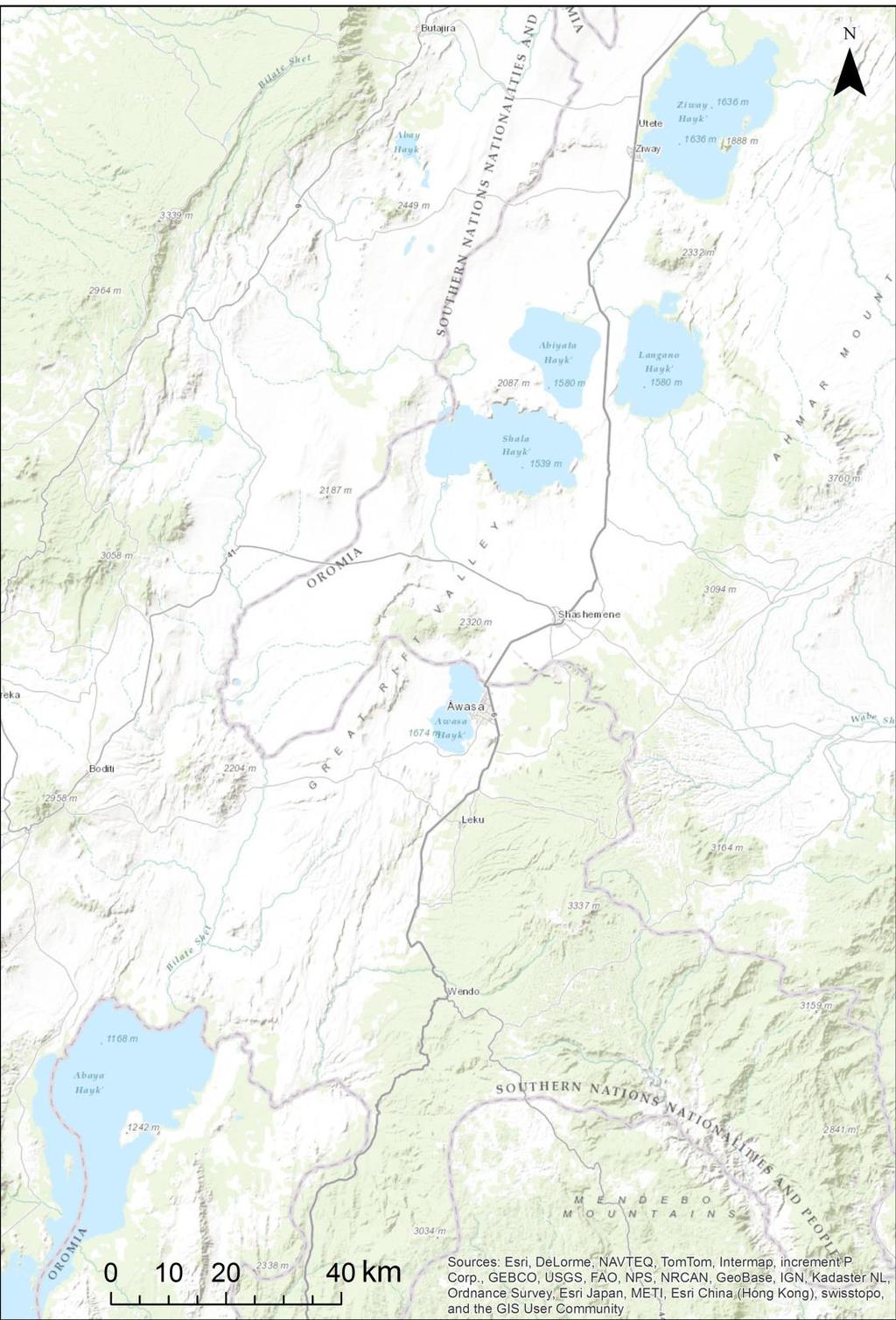
1 New observations obtained via applying remote sensing methods in geological hazard assessment, Southern Ethiopia Veronika Kopačková, Jan Mišurec Remote sensing Unit Czech Geological Survey, Klárov 3, Prague 1
2 Overview Remote sensing data Applications Morphotectonics Mapping moist soils (nearsubsurface water) Thermal anomalies, gradients Summary, future remarks
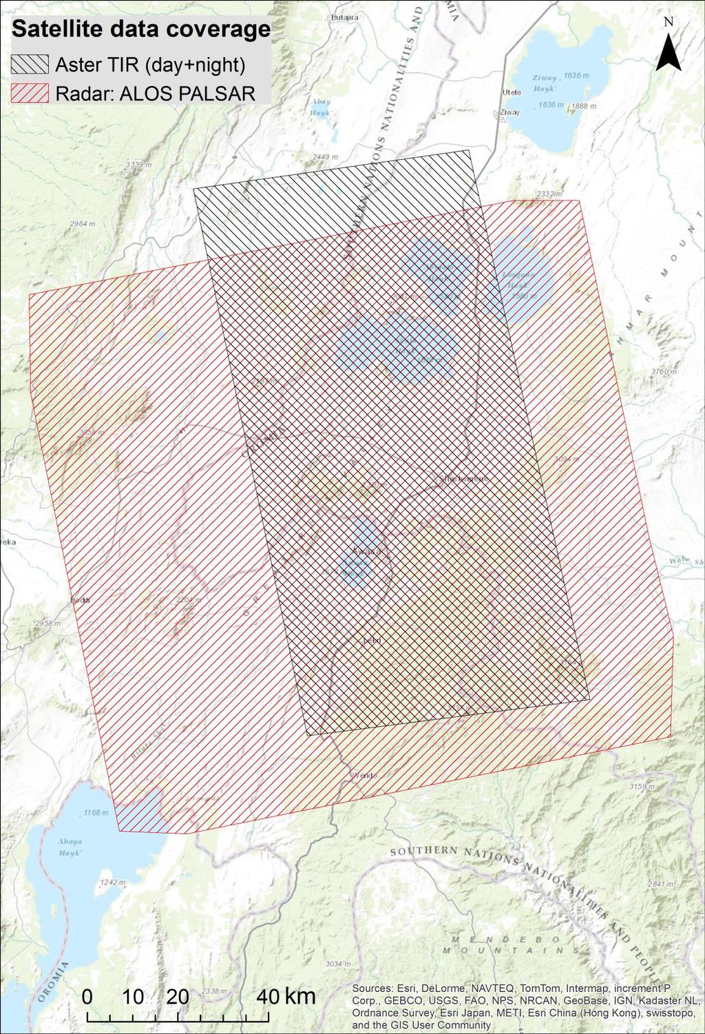
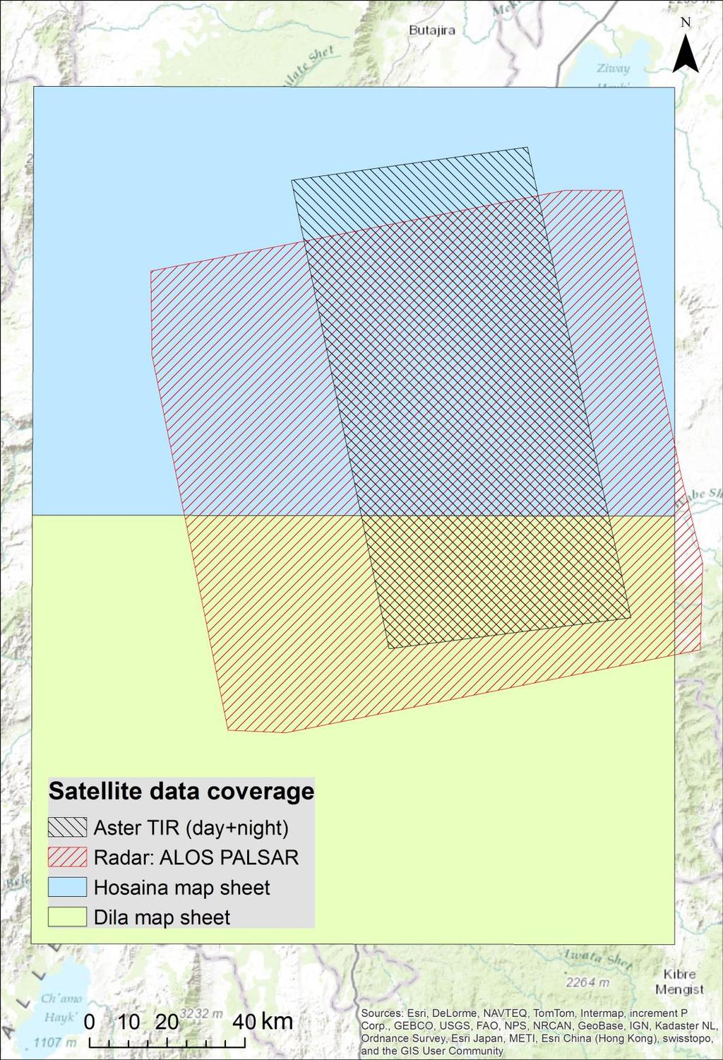
3 Overview on the RS data Digital elevation models (DEM) Satellite Radar data (active): ALOS PALSAR Satellite optical data (passive) : Aster data (thermal sensing: day, night) Landsat multi-temporal data
4


5 Radar data: ALOS PALSAR Soil Depth (cm) Profile of Soil Moisture Soil Moisture Active microwave sensor using L band frequencies to archive data Joint project of JAXA and JAROS Cloud-free, night/day images Dual (HV, HH) polarisation 12.5 m
 is an advanced multispectral")

6 Optical/Thermal data: ASTER Aster The Advanced Spaceborne Thermal Emission and Reflection Radiometer (ASTER) is an advanced multispectral imager that was launched on board NASA s Terra spacecraft in December, full scene 185km x 185 km : VNIR/SWIR/TIR Since 2008: VNIR/TIR
7 ALOS PALSAR Detection of lineamnets of geological /hydrogelogical origine Detecton of moist soils/near subsurface water

8 ALOS PALSAR data processing Computer based technique to automatically extract linear features from ALOS PALSAR image and to further assess their spatial pattern Validation (Czech Rep.): Structural field investigations Field geophysics: Symmetric Resistivity Profiling (SRP), Seismic refraction (SR)


 Map of joints")
9 Hypothesis that real fractural systems, discontinuity and fault planes appear in a digital image as spatially structured and oriented systems of small linear features (micro-lineaments) Fracture pattern (including faults and joints) Map of joints exposed on a sandstone bedding plane Fault pattern


10 ALOS PALSAR processing ALOS PALSAR Orthorectification Double transformation Lineament detection -Azimuth dependent gradient images -2nd order derivation Kernel filter Lineament extraction Correction of line geometry Geostatistical analysis -line topology, orientation (azimuth), length -Lineament Density Structural interpretation Validation


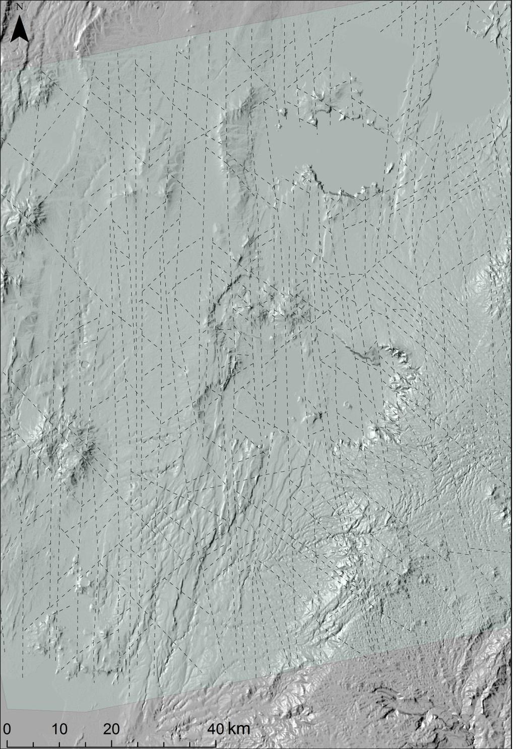
11 Lineamnets of geological /hydrogelogical origine


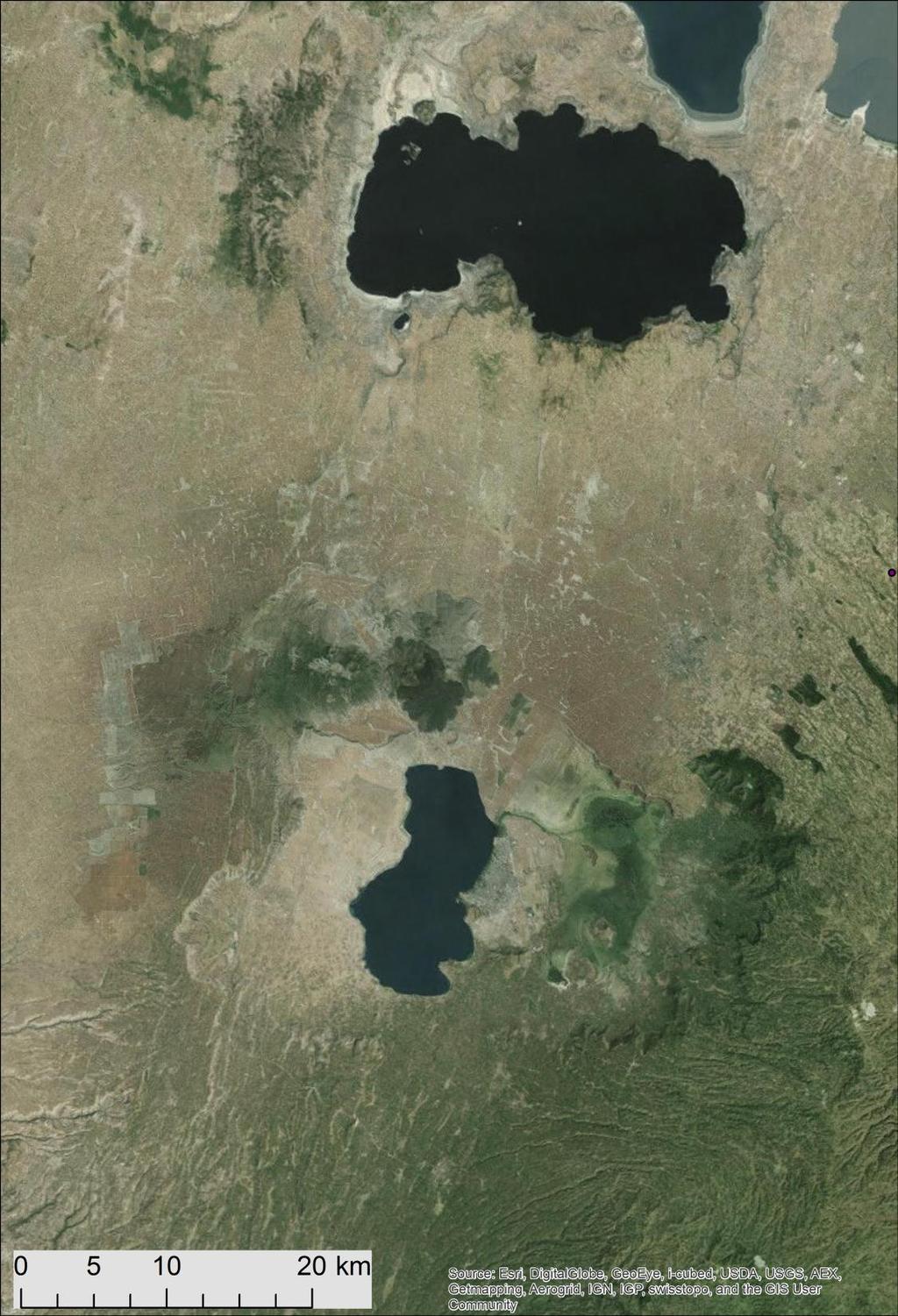
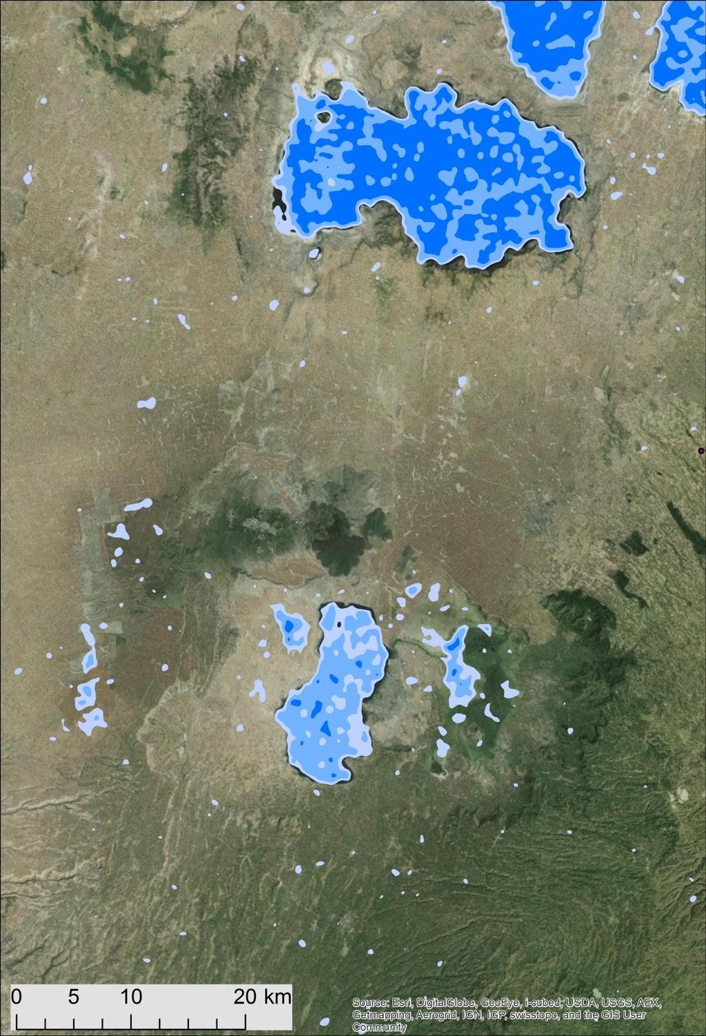
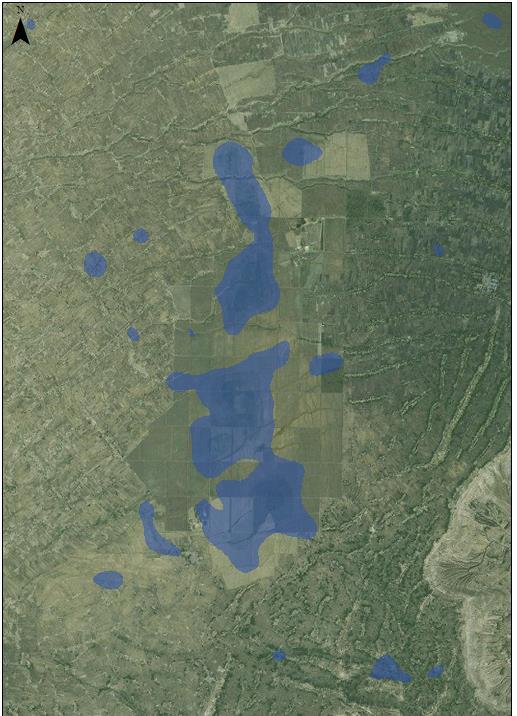
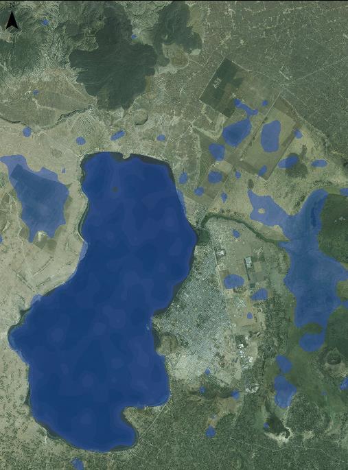
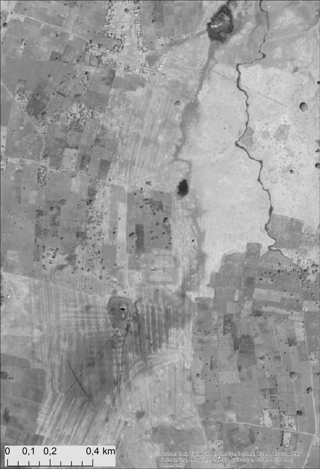
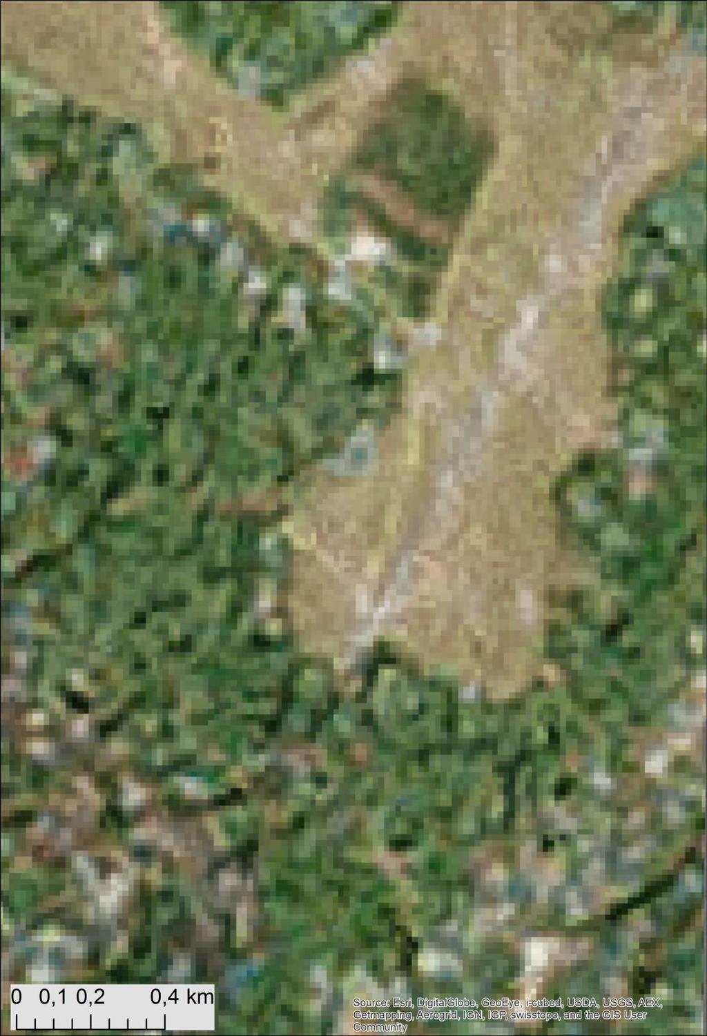
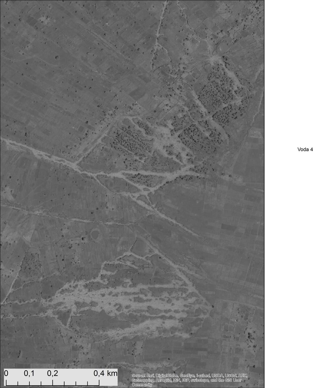
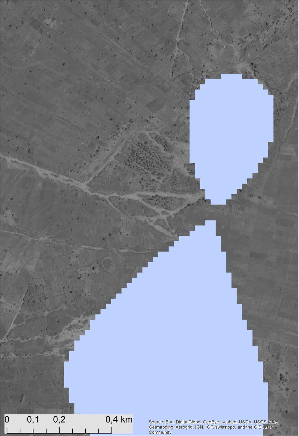
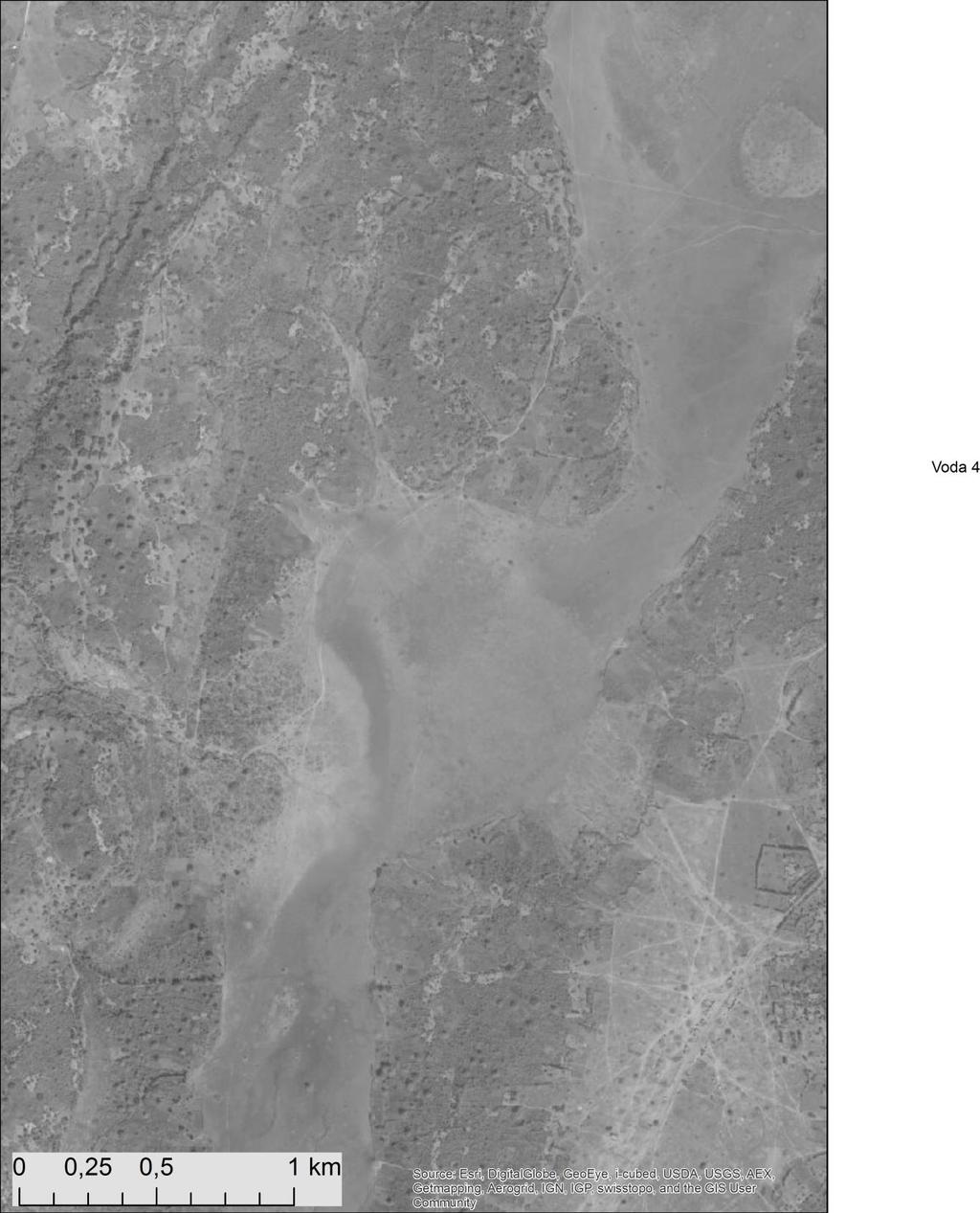
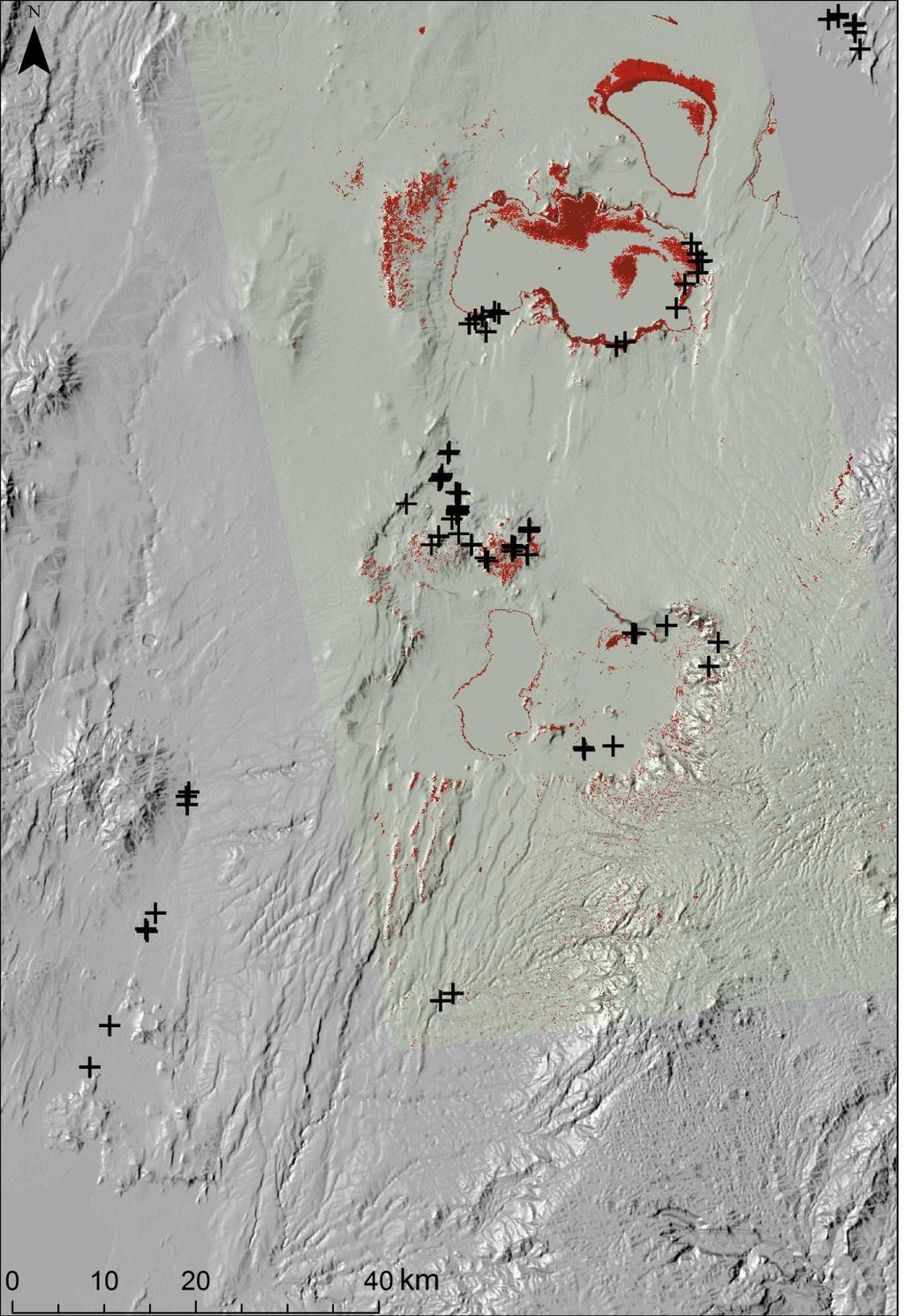
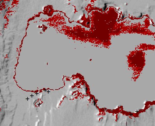
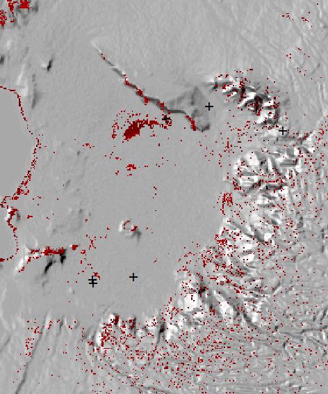
12 Detecton of moist soils/ near subsurface water
13
14
15
16

17

 Smaller differences between night/day")

18 ASTER thermal analysis Water bodies Day: colder from other surfaces Night: warmer than other surfaces Thermal hot spots (night/day images) Stable night/day temperature Smaller differences between night/day temperature (2-5 C) Smaller differences between night/day temperature close to 0 C) ASTER day thermal gradient ASTER night thermal gradient ASTER night/day thermal gradient difference C Low Temperature High
19 Aster thermal data Corrected to atmospheric and topographic effect (ATCOR) Normalized to albedo (day scenes): Apparent Thermal Inertia (ATI): ATI=(1-Albedo)/ΔT (day-night) is commonly used to describe the resistance of a material to temperature changes: higher resistance smaller ΔT larger ATI Water soil moisture Day: colder from other surfaces Night: warmer than other surfaces Smaller differences between night/day temperature (2-5 C)
20 Apparent Thermal Inertia (ATI): Exposed surfaces Water bodies T x 100 ( C) T x 100 ( C) mozaika_te 2000 mozaika_te day ASTL1B_200 night 3000 ASTL1B_

21 Thermal anomalies

22 Synthesis
23 Summary Combination of passive and active remote sensing data brings big benefits Morphometry has further implications for land form mapping, geomorphology, erosion and slope stability assesment Structures interpreted on the basis of radar ALOS PALSAR data needs to be correlated with the field structural data (extrapolation, synthesis) ASTER thermal images suitable for mapping surface/subsurface water, this could be correlated with water table level, implications for agriculture (?) ASTER night/day diference images suitable for mapping water bodies as well as hot spots Final results with the end of the projects
Structural approach combining ALOS PALSAR linear feature extraction with field structural and geophysical investigations
 Structural approach combining ALOS PALSAR linear feature extraction with field structural and geophysical investigations 1 Veronika Kopačková, 1 Jan Franěk, 1 Kryštof Verner, 1 Karel Martínek, 2 Michal
Czech Geological Survey Remote sensing unit
 Czech Geological Survey Remote sensing unit CGS Remote sensing unit Who we are? Part of the Dpt. of Regional geology of crystalline complexes Since 2005 Processing of satellite and airborne data Geoinformation
Geological Mapping Using EO Data for Onshore O&G Exploration
 Geological Mapping Using EO Data for Onshore O&G Exploration Michael Hall ESA Oil and Gas Workshop, Frascati, Italy michael.hall@infoterra-global.com Why use EO data for Geological Mapping? Availability
DAMAGE DETECTION OF THE 2008 SICHUAN, CHINA EARTHQUAKE FROM ALOS OPTICAL IMAGES
 DAMAGE DETECTION OF THE 2008 SICHUAN, CHINA EARTHQUAKE FROM ALOS OPTICAL IMAGES Wen Liu, Fumio Yamazaki Department of Urban Environment Systems, Graduate School of Engineering, Chiba University, 1-33,
Positional accuracy of the drainage networks extracted from ASTER and SRTM for the Gorongosa National Park region - Comparative analysis
 Positional accuracy of the drainage networks extracted from ASTER and SRTM for the Gorongosa National Park region - Comparative analysis Tiago CARMO 1, Cidália C. FONTE 1,2 1 Departamento de Matemática,
2013 Esri Europe, Middle East and Africa User Conference October 23-25, 2013 Munich, Germany
 2013 Esri Europe, Middle East and Africa User Conference October 23-25, 2013 Munich, Germany Environmental and Disaster Management System in the Valles Altos Region in Carabobo / NW-Venezuela Prof.Dr.habil.Barbara
GIS and Remote Sensing
 Spring School Land use and the vulnerability of socio-ecosystems to climate change: remote sensing and modelling techniques GIS and Remote Sensing Katerina Tzavella Project Researcher PhD candidate Technology
Bonn, Germany MOUTAZ DALATI. General Organization for Remote Sensing ( GORS ), Syria Advisor to the General Director of GORS,
, Syria Advisor to the General Director of GORS,") Bonn, Germany Early Warning System is needed for Earthquakes disaster mitigation in Syria Case Study: Detecting and Monitoring the Active faulting zones along the Afro-Arabian-Syrian Rift System MOUTAZ
Bonn, Germany Early Warning System is needed for Earthquakes disaster mitigation in Syria Case Study: Detecting and Monitoring the Active faulting zones along the Afro-Arabian-Syrian Rift System MOUTAZ
CEOS Overview and JAXA Plans for Water Cycle Observation
 CEOS Overview and JAXA Plans for Water Cycle Observation Asian Water Cycle Symposium November 2-4, 2005 Tokyo, Japan Chu Ishida Japan Aerospace Exploration Agency (JAXA) Contents 1. CEOS overview 2. CEOS
Interpretation of Polar-orbiting Satellite Observations. Atmospheric Instrumentation
 Interpretation of Polar-orbiting Satellite Observations Outline Polar-Orbiting Observations: Review of Polar-Orbiting Satellite Systems Overview of Currently Active Satellites / Sensors Overview of Sensor
Microwave Remote Sensing of Soil Moisture. Y.S. Rao CSRE, IIT, Bombay
 Microwave Remote Sensing of Soil Moisture Y.S. Rao CSRE, IIT, Bombay Soil Moisture (SM) Agriculture Hydrology Meteorology Measurement Techniques Survey of methods for soil moisture determination, Water
Analysing Land Surface Emissivity with Multispectral Thermal Infrared Data
 2nd Workshop on Remote Sensing and Modeling of Surface Properties 9-11 June 2009, Météo France, Toulouse, France Analysing Land Surface Emissivity with Multispectral Thermal Infrared Data Maria Mira, Thomas
Uses of free satellite imagery for Disaster Risk Reduction (DRR)
") Centre of Applied Geoscience, Disaster Risk Reduction Research Group, School of Earth and Environmental Science, University of Portsmouth, UK Uses of free satellite imagery for Disaster Risk Reduction
Centre of Applied Geoscience, Disaster Risk Reduction Research Group, School of Earth and Environmental Science, University of Portsmouth, UK Uses of free satellite imagery for Disaster Risk Reduction
Digital Elevation Model (DEM) Generation from Stereo Images
 Generation from Stereo Images") Pertanika J. Sci. & Technol. 19 (S): 77-82 (2011) ISSN: 0128-7680 Universiti Putra Malaysia Press Digital Elevation Model (DEM) Generation from Stereo Images C. E. Joanna Tan *, M. Z. Mat Jafri, H. S.
Pertanika J. Sci. & Technol. 19 (S): 77-82 (2011) ISSN: 0128-7680 Universiti Putra Malaysia Press Digital Elevation Model (DEM) Generation from Stereo Images C. E. Joanna Tan *, M. Z. Mat Jafri, H. S.
ECVs: What s operational and what still requires R&D?
 Glaciers_cci input on ECVs: What s operational and what still requires R&D? Frank Paul* Department of Geography, University of Zurich *on behalf of the Glaciers_cci consortium Google Earth Operational
Figure B.15 - Example of plotting the landslide potential points
 Figure B.15 - Example of plotting the landslide potential points Figure B.16 - Example of landslide potential map based on topographic factor in north area of kabupaten Jember 37 from 61 Figure B.17 -
This module presents remotely sensed assessment (choice of sensors and resolutions; airborne or ground based sensors; ground truthing)
") This module presents remotely sensed assessment (choice of sensors and resolutions; airborne or ground based sensors; ground truthing) 1 In this presentation you will be introduced to approaches for using
This module presents remotely sensed assessment (choice of sensors and resolutions; airborne or ground based sensors; ground truthing) 1 In this presentation you will be introduced to approaches for using
EVALUATION OF CLASSIFICATION METHODS WITH POLARIMETRIC ALOS/PALSAR DATA
 EVALUATION OF CLASSIFICATION METHODS WITH POLARIMETRIC ALOS/PALSAR DATA Anne LÖNNQVIST a, Yrjö RAUSTE a, Heikki AHOLA a, Matthieu MOLINIER a, and Tuomas HÄME a a VTT Technical Research Centre of Finland,
ENGRG Introduction to GIS
 ENGRG 59910 Introduction to GIS Michael Piasecki March 17, 2014 Lecture 08: Terrain Analysis Outline: Terrain Analysis Earth Surface Representation Contour TIN Mass Points Digital Elevation Models Slope
ACCURACY ASSESSMENT OF ASTER GLOBAL DEM OVER TURKEY
 ACCURACY ASSESSMENT OF ASTER GLOBAL DEM OVER TURKEY E. Sertel a a ITU, Civil Engineering Faculty, Geomatic Engineering Department, 34469 Maslak Istanbul, Turkey sertele@itu.edu.tr Commission IV, WG IV/6
Model based forest height estimation with ALOS/PalSAR: A first study.
 Model based forest height estimation with ALOS/PalSAR: A first study. K.P. Papathanassiou*, I. Hajnsek*, T.Mette*, S.R. Cloude** and A. Moreira* * (DLR) (DLR-HR) Oberpfaffenhofen, Germany ** AEL Consultants
Lesson 4b Remote Sensing and geospatial analysis to integrate observations over larger scales
 Lesson 4b Remote Sensing and geospatial analysis to integrate observations over larger scales We have discussed static sensors, human-based (participatory) sensing, and mobile sensing Remote sensing: Satellite
A new perspective on aerosol direct radiative effects in South Atlantic and Southern Africa
 A new perspective on aerosol direct radiative effects in South Atlantic and Southern Africa Ian Chang and Sundar A. Christopher Department of Atmospheric Science University of Alabama in Huntsville, U.S.A.
ENGRG Introduction to GIS
 ENGRG 59910 Introduction to GIS Michael Piasecki November 17, 2017 Lecture 11: Terrain Analysis Outline: Terrain Analysis Earth Surface Representation Contour TIN Mass Points Digital Elevation Models Slope
APPENDIX 2 OVERVIEW OF THE GLOBAL PRECIPITATION MEASUREMENT (GPM) AND THE TROPICAL RAINFALL MEASURING MISSION (TRMM) 2-1
 AND THE TROPICAL RAINFALL MEASURING MISSION (TRMM) 2-1") APPENDIX 2 OVERVIEW OF THE GLOBAL PRECIPITATION MEASUREMENT (GPM) AND THE TROPICAL RAINFALL MEASURING MISSION (TRMM) 2-1 1. Introduction Precipitation is one of most important environmental parameters.
APPENDIX 2 OVERVIEW OF THE GLOBAL PRECIPITATION MEASUREMENT (GPM) AND THE TROPICAL RAINFALL MEASURING MISSION (TRMM) 2-1 1. Introduction Precipitation is one of most important environmental parameters.
INTEGRATION OF PALSAR AND ASTER SATELLITE DATA FOR GEOLOGICAL MAPPING IN TROPICS
 INTEGRATION OF PALSAR AND ASTER SATELLITE DATA FOR GEOLOGICAL MAPPING IN TROPICS Amin Beiranvand Pour*, Mazlan Hashim Geoscience and Digital Earth Centre (Geo-DEC) Research Institute for Sustainability
Geo-hazard Potential Mapping Using GIS and Artificial Intelligence
 Geo-hazard Potential Mapping Using GIS and Artificial Intelligence Theoretical Background and Uses Case from Namibia Andreas Knobloch 1, Dr Andreas Barth 1, Ellen Dickmayer 1, Israel Hasheela 2, Andreas
EXTRACTION OF FLOODED AREAS DUE THE 2015 KANTO-TOHOKU HEAVY RAINFALL IN JAPAN USING PALSAR-2 IMAGES
 EXTRACTION OF FLOODED AREAS DUE THE 2015 KANTO-TOHOKU HEAVY RAINFALL IN JAPAN USING PALSAR-2 IMAGES F. Yamazaki a, *, W. Liu a a Chiba University, Graduate School of Engineering, Chiba 263-8522, Japan
CORRELATION BETWEEN URBAN HEAT ISLAND EFFECT AND THE THERMAL INERTIA USING ASTER DATA IN BEIJING, CHINA
 CORRELATION BETWEEN URBAN HEAT ISLAND EFFECT AND THE THERMAL INERTIA USING ASTER DATA IN BEIJING, CHINA Yurong CHEN a, *, Mingyi DU a, Rentao DONG b a School of Geomatics and Urban Information, Beijing
Satellite ASTER Global Geoscience Maps
 Satellite ASTER Global Geoscience Maps Michael Abrams Jet Propulsion Laboratory, California Institute of Technology, Pasadena USA (c) 2017 California Institute of Technology. Government sponsorship acknowledged.
2 nd Asia CryoNet Workshop Current methods of measurement of the cryosphere in Asia consistency and issues
 2 nd Asia CryoNet Workshop Current methods of measurement of the cryosphere in Asia consistency and issues Dongqi Zhang, Cunde Xiao, Vladimir Aizen and Wolfgang Schöner Feb.5, 2016, Salekhard, Russia 1.
Surface Anomalies Prior to Earthquakes
 Surface Anomalies Prior to Earthquakes Habibeh Valizadeh, Shattri B. Mansor Husaini Omar and Farid Azad Department of Civil Engineering Universiti Putra Malaysia Serdang, Selangor Malaysia shattri@eng.upm.edu.my
METRIC tm. Mapping Evapotranspiration at high Resolution with Internalized Calibration. Shifa Dinesh
 METRIC tm Mapping Evapotranspiration at high Resolution with Internalized Calibration Shifa Dinesh Outline Introduction Background of METRIC tm Surface Energy Balance Image Processing Estimation of Energy
Hyperspectral Atmospheric Correction
 Hyperspectral Atmospheric Correction Bo-Cai Gao June 2015 Remote Sensing Division Naval Research Laboratory, Washington, DC USA BACKGROUND The concept of imaging spectroscopy, or hyperspectral imaging,
ERDAS ER Mapper Software
 ERDAS ER Mapper Software ER Mapper professional software is widely used in exploration industry and geologist worldwide for satellite image exploitation. It is known for its:- Powerful image processing
Integration of remotely sensed data into a GIS of soil resources
 UN / Austria / ESA Symposium Space Tools and Solutions for Monitoring the Atmosphere and Land Cover Integration of remotely sensed data into a GIS of soil resources Diana Hanganu,, Roxana Vintila ICPA
Contribution to global Earth observation from satellites
 Contribution to global Earth observation from satellites - JAXA s Earth Observation strategy - April 16, 2008 Makoto Kajii Japan Aerospace Exploration Agency Earth Observation Summits and GEOSS 1 st EO
PREDICTION AND MONITORING OF OCEANIC DISASTERS USING MICROWAVE REMOTE SENSING TECHNIQUES
 PREDICTION AND MONITORING OF OCEANIC DISASTERS USING MICROWAVE REMOTE SENSING TECHNIQUES O P N Calla International Centre for Radio Science, OM NIWAS A-23, Shastri Nagar, Jodhpur-342 003 Abstract The disasters
Learning Objectives. Thermal Remote Sensing. Thermal = Emitted Infrared
 November 2014 lava flow on Kilauea (USGS Volcano Observatory) (http://hvo.wr.usgs.gov) Landsat-based thermal change of Nisyros Island (volcanic) Thermal Remote Sensing Distinguishing materials on the ground
Change Detection Over Sokolov Open Pit Mine Areas, Czech Republic, Using Multi Temporal HyMAP Data ( )
") Change Detection Over Sokolov Open Pit Mine Areas, Czech Republic, Using Multi Temporal HyMAP Data (2009 2010) S. Adar* a G. Notesco b, A. Brook b, I. Livne b, P. Rojik c, V. Kopackova d, K. Zelenkova
Change Detection Over Sokolov Open Pit Mine Areas, Czech Republic, Using Multi Temporal HyMAP Data (2009 2010) S. Adar* a G. Notesco b, A. Brook b, I. Livne b, P. Rojik c, V. Kopackova d, K. Zelenkova
Satellite Remote Sensing for Ocean
 Satellite Remote Sensing for Ocean August 17, 2017 Masatoshi Kamei RESTEC All rights reserved RESTEC 2015 Contents 1. About RESTEC and Remote Sensing 2. Example of Remote Sensing Technology 3. Remote Sensing
Estimation of Wavelet Based Spatially Enhanced Evapotranspiration Using Energy Balance Approach
 Estimation of Wavelet Based Spatially Enhanced Evapotranspiration Using Energy Balance Approach Dr.Gowri 1 Dr.Thirumalaivasan 2 1 Associate Professor, Jerusalem College of Engineering, Department of Civil
Fernanda Ledo G. Ramos (1) Fernando P. De Miranda (2) Federal University of Rio de Janeiro UFRJ/COPPE
 Fernando P. De Miranda (2) Federal University of Rio de Janeiro UFRJ/COPPE") USE OF INFORMATION DERIVED FROM RADAR REMOTE SENSING (RADARSAT-1 INTERFEROMETRY AND SRTM MOSAIC) FOR MAPPING NEOTECTONIC ACTIVITIES IN THE REGION OF MANAUS (AMAZONAS STATE) Fernanda Ledo G. Ramos (1) Fernando
USE OF INFORMATION DERIVED FROM RADAR REMOTE SENSING (RADARSAT-1 INTERFEROMETRY AND SRTM MOSAIC) FOR MAPPING NEOTECTONIC ACTIVITIES IN THE REGION OF MANAUS (AMAZONAS STATE) Fernanda Ledo G. Ramos (1) Fernando
Interferometric SAR analysis for Characterizing Surface Changes of an Active Volcano using Open Source Software
 Interferometric SAR analysis for Characterizing Surface Changes of an Active Volcano using Open Source Software Asep SAEPULOH1, Katsuaki KOIKE1, Makoto OMURA2 1 Department of Life and Environmental Sciences,
Geomorphologic Mapping by Airborne Laser Scanning in Southern Victoria Land
 Geomorphologic Mapping by Airborne Laser Scanning in Southern Victoria Land Bea Csatho, Terry Wilson, Tony Schenk, Garry McKenzie, Byrd Polar Research Center, The Ohio State University, Columbus, OH William
Remote sensing of sea ice
 Remote sensing of sea ice Ice concentration/extent Age/type Drift Melting Thickness Christian Haas Remote Sensing Methods Passive: senses shortwave (visible), thermal (infrared) or microwave radiation
Study of the Influence of Thin Cirrus Clouds on Satellite Radiances Using Raman Lidar and GOES Data
 Study of the Influence of Thin Cirrus Clouds on Satellite Radiances Using Raman Lidar and GOES Data D. N. Whiteman, D. O C. Starr, and G. Schwemmer National Aeronautics and Space Administration Goddard
PASSIVE MICROWAVE IMAGING. Dr. A. Bhattacharya
 1 PASSIVE MICROWAVE IMAGING Dr. A. Bhattacharya 2 Basic Principles of Passive Microwave Imaging Imaging with passive microwave is a complementary technology that needs an introduction to identify its role
Early Warning of Earthquakes Using Earth, Ocean and Atmospheric Parameters Observed From Satellite Data
 Early Warning of Earthquakes Using Earth, Ocean and Atmospheric Parameters Observed From Satellite Data Ramesh P. Singh Department of Civil Engineering, Indian Institute of Technology, Kanpur 208 016,
Application of remote sensing technologies for engineering for onshore pipelines in active dune fields
 Application of remote sensing technologies for engineering for onshore pipelines in active dune fields Jason Manning, Arup (jason.manning@arup.com) Dr Matthew Free, Arup (matthew.free@arup.com) Dr Charlie
GEOSENSE - GEOLOGICAL MAPPING
 GEOSENSE - GEOLOGICAL MAPPING Whatever the terrain you re working in (from desert to arctic to tropical jungle), whatever the tectonic setting, Geosense has undertaken geological mapping in similar regions.
ESRI GIS For Mining Seminar, 10 th August, 2016, Nairobi, Kenya. Spatial DATA Solutions for Mining
 ESRI GIS For Mining Seminar, 10 th August, 2016, Nairobi, Kenya Spatial DATA Solutions for Mining Spatial Data Solutions for Mining Spatial - Data that identifies the geographic location of features &
PRINCIPLES OF REMOTE SENSING. Electromagnetic Energy and Spectral Signatures
 PRINCIPLES OF REMOTE SENSING Electromagnetic Energy and Spectral Signatures Remote sensing is the science and art of acquiring and analyzing information about objects or phenomena from a distance. As humans,
JAXA Remote Sensing Satellite Missions Utilization for Earth and Environment Observation
 JAXA Remote Sensing Satellite Missions Utilization for Earth and Environment Observation 27 th June 2013 Toshiyoshi Kimura EORC/JAXA Inventory, Modeling and Climate Impacts of Greenhouse Gas emissions
Sediment-hosted/orogenic gold mineral systems exploration using PALSAR remote sensing data in Peninsular Malaysia
 IOP Conference Series: Earth and Environmental Science PAPER OPEN ACCESS Sediment-hosted/orogenic gold mineral systems exploration using PALSAR remote sensing data in Peninsular Malaysia To cite this article:
RADAR Remote Sensing Application Examples
 RADAR Remote Sensing Application Examples! All-weather capability: Microwave penetrates clouds! Construction of short-interval time series through cloud cover - crop-growth cycle! Roughness - Land cover,
Remote Sensing and GIS. Microwave Remote Sensing and its Applications
 Subject Paper No and Title Module No and Title Module Tag Geology Remote Sensing and GIS Microwave Remote Sensing and its Applications RS & GIS XVII Principal Investigator Co-Principal Investigator Co-Principal
Geoscience Australia Report on Cal/Val Activities
 Medhavy Thankappan Geoscience Australia Agency Report I Berlin May 6-8, 2015 Outline 1. Calibration / validation at Geoscience Australia Corner reflector infrastructure for SAR calibration (for information)
DLR s TerraSAR-X contributes to international fleet of radar satellites to map the Arctic and Antarctica
 DLR s TerraSAR-X contributes to international fleet of radar satellites to map the Arctic and Antarctica The polar regions play an important role in the Earth system. The snow and ice covered ocean and
The game changer for biodiversity? Mapping and monitoring invasive plants, floristic gradients and ecosystem properties using Sentinel-2
 The game changer for biodiversity? Mapping and monitoring invasive plants, floristic gradients and ecosystem properties using Sentinel-2 Van De Kerchove Ruben Marcel Buchhorn, Els Knaeps, Luc Bertels (VITO)
EMERGENCY PLANNING IN NORTHERN ALGERIA BASED ON REMOTE SENSING DATA IN RESPECT TO TSUNAMI HAZARD PREPAREDNESS
 EMERGENCY PLANNING IN NORTHERN ALGERIA BASED ON REMOTE SENSING DATA IN RESPECT TO TSUNAMI HAZARD PREPAREDNESS Barbara Theilen-Willige Technical University of Berlin, Institute of Applied Geosciences Department
Civil Engineering Journal
 Available online at www.civilejournal.org Civil Engineering Journal Vol. 1, No. 2, December, 2015 Comparative Study of Landsat and Aster Data by Morphometric Analysis Sujit Kumar a*, Tapasi Bhandary b
Remote Sensing of Snow GEOG 454 / 654
 Remote Sensing of Snow GEOG 454 / 654 What crysopheric questions can RS help to answer? 2 o Where is snow lying? (Snow-covered area or extent) o How much is there? o How rapidly is it melting? (Area, depth,
Rating of soil heterogeneity using by satellite images
 Rating of soil heterogeneity using by satellite images JAROSLAV NOVAK, VOJTECH LUKAS, JAN KREN Department of Agrosystems and Bioclimatology Mendel University in Brno Zemedelska 1, 613 00 Brno CZECH REPUBLIC
CONTRIBUTION OF SATELLITE IMAGERY TO SEARCH CLUES OF SURFACE DRAINAGE WITHIN AAC
 Pléiades Days, 2014 CONTRIBUTION OF SATELLITE IMAGERY TO SEARCH CLUES OF SURFACE DRAINAGE WITHIN 1. Methods, remote sensing 2. Applications of achieved results 3. Contact : Sébastien RUCQUOI & Christelle
History & Scope of Remote Sensing FOUNDATIONS
 History & Scope of Remote Sensing FOUNDATIONS Lecture Overview Introduction Overview of visual information Power of imagery Definition What is remote sensing? Definition standard for class History of Remote
Remote sensing, GIS and groundwater exploration
 Remote sensing, GIS and groundwater exploration Geraint Burrows CEO of Groundwater Relief 4 th United Nations / Pakistan / Prince Sultan Bin Abdulaziz International Prize for Water International Conference
Introduction to SMAP. ARSET Applied Remote Sensing Training. Jul. 20,
 National Aeronautics and Space Administration ARSET Applied Remote Sensing Training http://arset.gsfc.nasa.gov @NASAARSET Introduction to SMAP Jul. 20, 2016 www.nasa.gov Outline 1. Mission objectives 2.
Japanese Programs on Space and Water Applications
 Japanese Programs on Space and Water Applications Tamotsu IGARASHI Remote Sensing Technology Center of Japan June 2006 COPUOS 2006 Vienna International Centre Water-related hazards/disasters may occur
SPATIAL AND TEMPORAL MODELLING OF ECOSYSTEM SERVICES
 SPATIAL AND TEMPORAL MODELLING OF ECOSYSTEM SERVICES Solen Le Clec h, T.Decaëns, S. Dufour, M. Grimaldi, N. Jégou and J. Oszwald ACES Conference 2016 Jacksonville, Florida (USA). December, 5-9th : issues
PROANA A USEFUL SOFTWARE FOR TERRAIN ANALYSIS AND GEOENVIRONMENTAL APPLICATIONS STUDY CASE ON THE GEODYNAMIC EVOLUTION OF ARGOLIS PENINSULA, GREECE.
 PROANA A USEFUL SOFTWARE FOR TERRAIN ANALYSIS AND GEOENVIRONMENTAL APPLICATIONS STUDY CASE ON THE GEODYNAMIC EVOLUTION OF ARGOLIS PENINSULA, GREECE. Spyridoula Vassilopoulou * Institute of Cartography
AlOS-PALSAR data for Landslide Monitoring and Geological Mapping
 AlOS-PALSAR data for Landslide Monitoring and Geological Mapping Vern Singhroy, P-J Alasset, G Pavlic Canada Centre for Remote Sensing Ottawa, Canada vern.singhroy@ccrs.nrcan.gc.ca Objectives InSAR monitoring
Land Surface Temperature Measurements From the Split Window Channels of the NOAA 7 Advanced Very High Resolution Radiometer John C.
 Land Surface Temperature Measurements From the Split Window Channels of the NOAA 7 Advanced Very High Resolution Radiometer John C. Price Published in the Journal of Geophysical Research, 1984 Presented
Evaluating Flood Hazard Potential in Danang City, Vietnam Using FOSS4G
 Free and Open Source Software for Geospatial (FOSS4G) Conference Proceedings Volume 15 Seoul, South Korea Article 28 2015 Evaluating Flood Hazard Potential in Danang City, Vietnam Using FOSS4G An Tran
GEOG Lecture 8. Orbits, scale and trade-offs
 Environmental Remote Sensing GEOG 2021 Lecture 8 Orbits, scale and trade-offs Orbits revisit Orbits geostationary (36 000 km altitude) polar orbiting (200-1000 km altitude) Orbits revisit Orbits geostationary
Remote Sensing I: Basics
 Remote Sensing I: Basics Kelly M. Brunt Earth System Science Interdisciplinary Center, University of Maryland Cryospheric Science Laboratory, Goddard Space Flight Center kelly.m.brunt@nasa.gov (Based on
Ground-based Validation of spaceborne lidar measurements
 Ground-based Validation of spaceborne lidar measurements Ground-based Validation of spaceborne lidar measurements to make something officially acceptable or approved, to prove that something is correct
Thermal Infrared (TIR) Remote Sensing: Challenges in Hot Spot Detection
 Remote Sensing: Challenges in Hot Spot Detection") Thermal Infrared (TIR) Remote Sensing: Challenges in Hot Spot Detection ASF Seminar Series Anupma Prakash Day : Tuesday Date : March 9, 2004 Time : 2.00 pm to 2.30 pm Place : GI Auditorium Geophysical
Thermal Infrared (TIR) Remote Sensing: Challenges in Hot Spot Detection ASF Seminar Series Anupma Prakash Day : Tuesday Date : March 9, 2004 Time : 2.00 pm to 2.30 pm Place : GI Auditorium Geophysical
Route To A Remote Sensing Geology Career
 INFORMATION SYSTEMS LLC a U.S. company Route To A Remote Sensing Geology Career Today s Agenda: My Route Potential Employers & Skills Trends Going Forward Take-Away Messages GRSG - September 10, 2014 Cynthia
Pan-Arctic Digital Elevation Model (DEM)
") Pan-Arctic Digital Elevation Model (DEM) Tazio Strozzi and Maurizio Santoro Gamma Remote Sensing, Gümligen, Switzerland Annett Bartsch et al. Institute of Photogrammetry and Remote Sensing, TU Wien, Austria
Pan-Arctic Digital Elevation Model (DEM) Tazio Strozzi and Maurizio Santoro Gamma Remote Sensing, Gümligen, Switzerland Annett Bartsch et al. Institute of Photogrammetry and Remote Sensing, TU Wien, Austria
Projects in the Remote Sensing of Aerosols with focus on Air Quality
 Projects in the Remote Sensing of Aerosols with focus on Air Quality Faculty Leads Barry Gross (Satellite Remote Sensing), Fred Moshary (Lidar) Direct Supervision Post-Doc Yonghua Wu (Lidar) PhD Student
A Facility for Producing Consistent Remotely Sensed Biophysical Data Products of Australia
 TERRESTRIAL ECOSYSTEM RESEARCH NETWORK - AusCover - A Facility for Producing Consistent Remotely Sensed Biophysical Data Products of Australia June, 2011 Mervyn Lynch Professor of Remote Sensing Curtin
HY-2A Satellite User s Guide
 National Satellite Ocean Application Service 2013-5-16 Document Change Record Revision Date Changed Pages/Paragraphs Edit Description i Contents 1 Introduction to HY-2 Satellite... 1 2 HY-2 satellite data
HYPERSPECTRAL IMAGING
 1 HYPERSPECTRAL IMAGING Lecture 9 Multispectral Vs. Hyperspectral 2 The term hyperspectral usually refers to an instrument whose spectral bands are constrained to the region of solar illumination, i.e.,
Central Asia Regional Flash Flood Guidance System 4-6 October Hydrologic Research Center A Nonprofit, Public-Benefit Corporation
 http://www.hrcwater.org Central Asia Regional Flash Flood Guidance System 4-6 October 2016 Hydrologic Research Center A Nonprofit, Public-Benefit Corporation FFGS Snow Components Snow Accumulation and
CHANGE DETECTION USING REMOTE SENSING- LAND COVER CHANGE ANALYSIS OF THE TEBA CATCHMENT IN SPAIN (A CASE STUDY)
") CHANGE DETECTION USING REMOTE SENSING- LAND COVER CHANGE ANALYSIS OF THE TEBA CATCHMENT IN SPAIN (A CASE STUDY) Sharda Singh, Professor & Programme Director CENTRE FOR GEO-INFORMATICS RESEARCH AND TRAINING
CHANGE DETECTION USING REMOTE SENSING- LAND COVER CHANGE ANALYSIS OF THE TEBA CATCHMENT IN SPAIN (A CASE STUDY) Sharda Singh, Professor & Programme Director CENTRE FOR GEO-INFORMATICS RESEARCH AND TRAINING
F O U N D A T I O N A L C O U R S E
 F O U N D A T I O N A L C O U R S E December 6, 2018 Satellite Foundational Course for JPSS (SatFC-J) F O U N D A T I O N A L C O U R S E Introduction to Microwave Remote Sensing (with a focus on passive
Infrared Radiance of Mount Etna, Sicily
 Journal of Maps ISSN: (Print) 1744-5647 (Online) Journal homepage: http://www.tandfonline.com/loi/tjom20 Infrared Radiance of Mount Etna, Sicily Matthew Blackett To cite this article: Matthew Blackett
Assimilation of satellite derived soil moisture for weather forecasting
 Assimilation of satellite derived soil moisture for weather forecasting www.cawcr.gov.au Imtiaz Dharssi and Peter Steinle February 2011 SMOS/SMAP workshop, Monash University Summary In preparation of the
Instructional Objectives
 GE 6477 DISCONTINUOUS ROCK 8. Fracture Detection Dr. Norbert H. Maerz Missouri University of Science and Technology (573) 341-6714 norbert@mst.edu Instructional Objectives 1. List the advantages and disadvantages
P079 First Results from Spaceborne Radar Interferometry for the Study of Ground Displacements in Urban Areas SUMMARY
 P079 First Results from Spaceborne Radar Interferometry for the Study of Ground Displacements in Urban Areas C.M. Crosetto (Instituto de Geomatica), C.A. Casas (University of Barcelona), R.G. Ranieri (University
VISUALIZATION URBAN SPATIAL GROWTH OF DESERT CITIES FROM SATELLITE IMAGERY: A PRELIMINARY STUDY
 CO-439 VISUALIZATION URBAN SPATIAL GROWTH OF DESERT CITIES FROM SATELLITE IMAGERY: A PRELIMINARY STUDY YANG X. Florida State University, TALLAHASSEE, FLORIDA, UNITED STATES ABSTRACT Desert cities, particularly
Nick Varley Universidad de Colima, Mexico
 Nick Varley Universidad de Colima, Mexico nick@ucol.mx Remote sensing often is the first signal of a new eruption for remote volcanoes Fumarole direct temperature measurements Spring water temperatures
C N E S, U M R I R I S A
 M O N I T O R I N G U R B A N A R E A S W I T H S E N T I N E L - 2. APPLICATION TO THE UPDATE OF THE COPERNICUS HIGH RESOLUTION LAYER IMPERVIOUSNESS DEGREE O c t o b e r 2 5 th 2016, Brussels A n t o
GMES: calibration of remote sensing datasets
 GMES: calibration of remote sensing datasets Jeremy Morley Dept. Geomatic Engineering jmorley@ge.ucl.ac.uk December 2006 Outline Role of calibration & validation in remote sensing Types of calibration
Hazard Mapping Along the Dead Sea Shoreline
 FIG Working Week in Marrakech, Morocco 18-22 May 2011 Hazard Mapping Along the Dead Sea Shoreline Rami Al-Ruzouq, Abdullah Al-Zuobi, AbdEl-Rahman Abueladas, Emad Akkawi Department of Surveying and Geomatics
SMAP and SMOS Integrated Soil Moisture Validation. T. J. Jackson USDA ARS
 SMAP and SMOS Integrated Soil Moisture Validation T. J. Jackson USDA ARS Perspective Linkage of SMOS and SMAP soil moisture calibration and validation will have short and long term benefits for both missions.
Does the SDCP need inputs from geology?
 The British Geological Survey s Experience and Expertise in Supporting Projects such as the Sirte Depression Connection Project David Ovadia Director of International Kingsley Dunham Centre Keyworth Nottingham
JAXA agency report. Masumi MATSUNAGA Satellite Applications and Operations Center(SAOC), JAXA
, JAXA") JAXA agency report Masumi MATSUNAGA Satellite Applications and Operations Center(SAOC), JAXA JAXA Activities Space Transportation Human Space Activities Satellite Programs Lunar & Planetary Exploration
JAXA agency report Masumi MATSUNAGA Satellite Applications and Operations Center(SAOC), JAXA JAXA Activities Space Transportation Human Space Activities Satellite Programs Lunar & Planetary Exploration
Haiti Earthquake (12-Jan-2010) co-seismic motion using ALOS PALSAR
 co-seismic motion using ALOS PALSAR") Haiti Earthquake (12-Jan-2010) co-seismic motion using ALOS PALSAR Urs Wegmüller, Charles Werner, Maurizio Santoro Gamma Remote Sensing, CH-3073 Gümligen, Switzerland SAR data: JAXA, METI; PALSAR AO Project
Haiti Earthquake (12-Jan-2010) co-seismic motion using ALOS PALSAR Urs Wegmüller, Charles Werner, Maurizio Santoro Gamma Remote Sensing, CH-3073 Gümligen, Switzerland SAR data: JAXA, METI; PALSAR AO Project