Early Warning of Earthquakes Using Earth, Ocean and Atmospheric Parameters Observed From Satellite Data
|
|
|
- Domenic Hancock
- 6 years ago
- Views:
Transcription
1 Early Warning of Earthquakes Using Earth, Ocean and Atmospheric Parameters Observed From Satellite Data Ramesh P. Singh Department of Civil Engineering, Indian Institute of Technology, Kanpur , India Guido Cervone and Menas Kafatos Center for Earth Observing Space Research, School of Computational Sciences, George Mason University, Fairfax, VA 22030, USA


2 Possible earthquake precursors Current studies of electromagnetic methods for short-term EQ prediction. Land-Ocean-Atmosphere-Ionosphere coupling
3 Globe - Land, Ocean and Atmosphere Land - 30% and Ocean 70%, (atmosphere is linkage between land and Ocean) Earthquakes Land and Ocean Effect can be seen on the earth, ocean and atmosphere Ground monitoring using Geophysical methods It was difficult to find complementary behavior
4 It is now believed that strong coupling exists between Land-Ocean-Atmosphere-Ionosphere Here, we want to show complementary behavior of land, ocean, atmosphere and ionosphere parameters prior to the earthquake events. All these parameters are deduced from satellite remote sensing data.


5 Remote Sensing Monitoring using optical and microwave sensors It is now easy to study complementary behavior
6 Land, Ocean and atmospheric Parameters Surface Latent Heat Flux Water Vapor Cloud cover Chlorophyll Concentration (MODIS) Sea Surface Temperature (TMI satellite) Total Electron Content (using GPS and TOPEX satellite) Land Skin Temperature Moisture content


7 Gujarat Earthquake (India) Region WESTERN INDIA; Date-Time :40:30 UTC, Location 23.40N 70.32E; Depth Km; Magnitude 7.7 ; Source USGS NEIC (R.P.Singh WWW source)


![Anomaly [ 0 C] 0-4](/docs-images/76/74408266/images/8-2.jpg "LST LST Running")


8 January 01 January 20 January 21 January 26 Ouzounov 8 and Freund, LST Anomaly [ 0 C] 0-4 LST LST Running average Bhuj Earthquake (Gujarat, India) December January 2001 [days] February 2001
9 TIR anomalies <-> Rn monitoring Gujarat Earthquake (India); Date-Time :40:30 UTC, Location 23.40N 70.32E; Depth Km; Magnitude 7.7 ; (USGS NEIC) Radon Data in Soil-gas and Groundwater for Bhuj Earthquake Radon Conc. (Bq/L) Χ 2σ Χ 2σ Χ+2σ Χ+2σ Χ Χ Bhuj TIR Anomaly Bhuj Eq Soil-gas Groundwater Bhuj (Gujarat, India) Earthquake Jan, Time Window ( Jan. 2001) (Virk et al. 2001)
10 Skin temperature of the Earth change significantly Seismologists do not believe since no thermal anomaly is found at the focal region and in surrounding region Cause??


11 A lively touch for skin temperature The Creation of Adam, Sistine Chapel, by Michelangelo 1511.
12 Complementary Parameters Jan 6, 2001 Jan 21, 2001 Jan 28, 2001 Singh et al., 2001, 2006 (a) January 18, 2001 (b) January 26, 2001 (c) February 3, 2001
![TEC GPS data and MODIS LST for Gujarat, Jan 2001 8 LST Anomaly [ 0 C] 4 0-4 LST LST Running average Bhuj 01.26.](/docs-images/76/74408266/images/13-0.jpg "2001 Earthquake (Gujarat, India) -8 5 10 15 20 25 30 December 2000 5 10 15 20 25 30 January 2001 [days] 5 10 15 20 25 February 2001 MODIS Night time LST ISSC")
13 TEC GPS data and MODIS LST for Gujarat, Jan LST Anomaly [ 0 C] LST LST Running average Bhuj Earthquake (Gujarat, India) December January 2001 [days] February 2001 MODIS Night time LST ISSC GPS Receiver Lat 13, Long 76 [Pulinets et al, 2003}

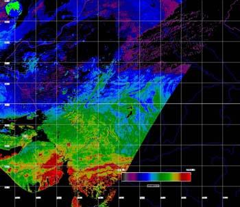
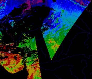
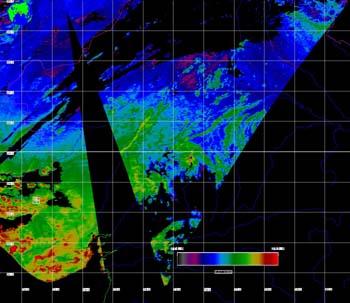
14 26 Jan N E Mw= Km GUJARAT, INDIA Cervone et al., 2005

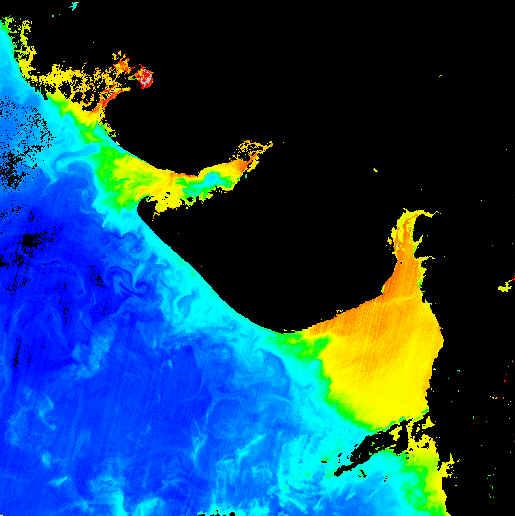
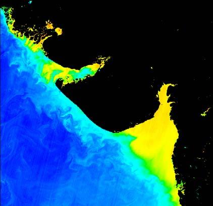
15 SLHF Anomalies Cervone et al. 2005
 http://www.physicalgeography.")
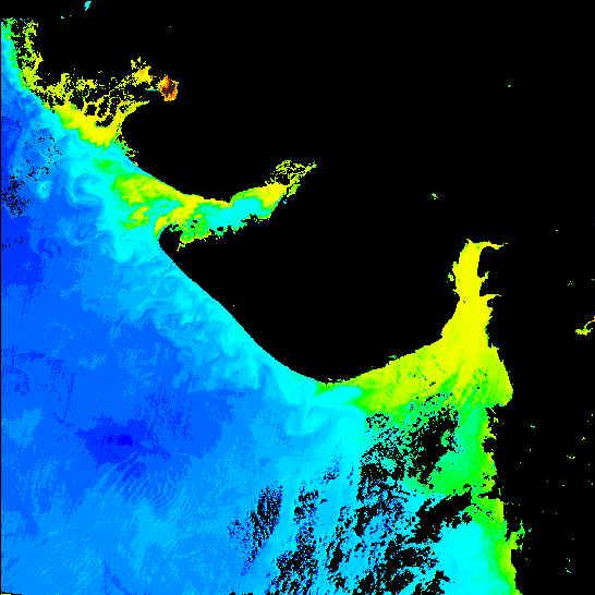
16 Surface Latent Heat Flux (SLHF) Data LH: Energy required to change to a different state of matter SLHF: Global movement of latent heat energy through circulations of air and water SLHF: possible earthquake precursor (Dey and Singh, 2004, Cervone et al, 2004,2005)
17 SLHF Data Anomalies The origin of the anomalous SLHF is likely to be related with increase of the surface temperature caused by: Crustal deformation Release of gases Increase in humidity and pressure Local greenhouse
18 Identification of Anomalous Peaks Which are the anomalous peaks? How are they distributed in the space? Which peaks are associated with earthquakes?
19 SLHF anomalies are characterized with the earthquakes of Magnitude more than 5.5 Focal depth less than 30 km Close to the coasts and also near the areas surrounded by snow cover


20 2 Greek Earthquakes 8 Aug 2003 Mw=6.7 1 Mar 2004 Mw=5.7 G. Cervone et al., 2004 Wavelet maxima curves of surface latent heat flux associated with two recent Greek earthquakes Natural Hazards and Earth System Science, Vol. 4, pp ,

21 SLHF Over the Epicenters

22 Spatial and Temporal Continuity Spatial Continuity: Precise geometrical continuity Cervone et al. (2004) Grid Number
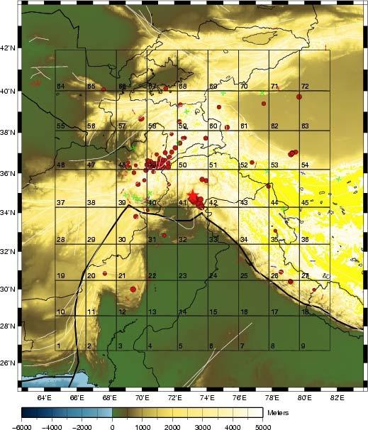
23 Pakistan Earthquake


![LST night time [K] 290 280 270 260 250 9/15/05](/docs-images/76/74408266/images/24-3.jpg "9/20/05 9/25/05 9/30/05 10/5/05 10/10/05 10/15/05")
24 TIR <-> SLHF M 7.6 Kashmir /PAKISTAN, 2005, October 8 03:50:40 UTC SLHF anomaly 300 LST LST_2005 LSTaver+sigma LSTaver-sigma TIR anomaly MODIS Terra LST night time [K] /15/05 9/20/05 9/25/05 9/30/05 10/5/05 10/10/05 10/15/05 10/20/05 Sept-Oct 2005, days LST + LST τ τ OLR anomaly

25 Examples of ionospheric perturbations in possible correlation with Kashmir earthquake, , M6.0 DEMETER Kashmir, Oct 23, 2005 M=6.0 Lat=34.88N Lon=73.4E 15:04 GMT One hour before the quake Ouzounov et al. 2006


26 Northern Sumatra, Dec 26, 2004 SLHF

27 Joint EM Analysis SLHF anomalies and earthquakes with magnitude > 5 Large Anomaly ~ 4 Days from Large Anomaly ~ 3 Days from Largest Anomaly Highest Value Center of Fracture Zone ~ 14 Days From Smaller Anomaly Highest Value at Epicenter ~ 2 Days from

28 Sumatra Earthquake: Dec. 26, 2004 GPS Precipitable Water Vapor (mm): hourly coco
29

30 25 Sep N E Mw= TOKACHI, JAPAN Night Time EM Variations Hokkaido Night Time EM Variations Kamchatka Cervone et al., 2006
31 CQuake earthquakes analized since November 2004 Results usually available 30 minutes after each event
32 Conclusion Satellite data shows promising results for Earthquake Precursors, in spite of numerous limitations. It is believed that with the GEOSS (Global Earth Observation System of Systems will provide a new insights in Early Warning to Earthquake community
33
34 Comparison with other years, NTUS (2003 and 2004)
35 Comparison with other years BAKO (2003 and 2004)
36
An early warning system for coastal earthquakes
 Advances in Space Research 37 (2006) 636 642 www.elsevier.com/locate/asr An early warning system for coastal earthquakes Guido Cervone a, *, Menas Kafatos a, Domenico Napoletani b, Ramesh P. Singh a,c
Interdisciplinary Framework to Reveal Earthquake Precursory Phenomena in Seismically Active Areas
 Interdisciplinary Framework to Reveal Earthquake Precursory Phenomena in Seismically Active Areas D.Ouzounov 1,2, S.Pulinets 3, M.Kafatos 1, P.Taylor 2 1 Chapman University, Orange, CA 92866, USA 2 NASA
Surface Anomalies Prior to Earthquakes
 Surface Anomalies Prior to Earthquakes Habibeh Valizadeh, Shattri B. Mansor Husaini Omar and Farid Azad Department of Civil Engineering Universiti Putra Malaysia Serdang, Selangor Malaysia shattri@eng.upm.edu.my
Surface latent heat flux as an earthquake precursor
 Surface latent heat flux as an earthquake precursor S. Dey, R. P. Singh To cite this version: S. Dey, R. P. Singh. Surface latent heat flux as an earthquake precursor. Natural Hazards and Earth System
Multi-parameter observations of atmospheric pre-earthquake signals and their validation: Potential for Future
 Multi-parameter observations of atmospheric pre-earthquake signals and their validation: Potential for Future Dimitar Ouzounov and Menas Kafatos Chapman University, Orange, CA CSEP Workshop, May 5-7, 2013
Anomalous increase of chlorophyll concentrations associated with earthquakes
 Advances in Space Research 37 (2006) 671 680 www.elsevier.com/locate/asr Anomalous increase of chlorophyll concentrations associated with earthquakes Ramesh P. Singh a,b, *, Sagnik Dey a, Sanjeeb Bhoi
Sensor Web Approach for Earthquake studies. D. Ouzounov
 1 Application of Remote Sensing Technologies for Disaster Risk Management: Mutisensor approach of analyzing atmospheric signals and search for possible earthquake precursors D. Ouzounov 1,4, S. Habib 2,
Radon Precursory Anomalies for Some Earthquakes in N-W Himalaya, India
 Radon Precursory Anomalies for Some Earthquakes in N-W Himalaya, India Vivek Walia 1, Hardev Singh Virk 2, Tsanyao Frank Yang 3, Monika Walia 3, Bikramjit Singh Bajwa 2 1 National Center for Research on
Generic precursors to coastal earthquakes: Inferences from Denali fault earthquake
 Tectonophysics 431 (2007) 231 240 www.elsevier.com/locate/tecto Generic precursors to coastal earthquakes: Inferences from Denali fault earthquake Ramesh P. Singh a,b,, Guido Cervone b, Vijay P. Singh
Satellite Based Precursor Observation Technique (SPOT) A Study on Earthquakes Occurred During Jan March, 2016 with Magnitude Greater Than 7.
 A Study on Earthquakes Occurred During Jan March, 2016 with Magnitude Greater Than 7.") www.cafetinnova.org Indexed in Scopus Compendex and Geobase Elsevier, Geo-Ref Information Services-USA, List B of Scientific Journals, Poland, Directory of Research Journals ISSN 0974-5904, Volume 09,
www.cafetinnova.org Indexed in Scopus Compendex and Geobase Elsevier, Geo-Ref Information Services-USA, List B of Scientific Journals, Poland, Directory of Research Journals ISSN 0974-5904, Volume 09,
Indian National (Weather) SATellites for Agrometeorological Applications
 SATellites for Agrometeorological Applications") Indian National (Weather) SATellites for Agrometeorological Applications Bimal K. Bhattacharya Agriculture-Terrestrial Biosphere- Hydrology Group Space Applications Centre (ISRO) Ahmedabad 380015, India
Indian National (Weather) SATellites for Agrometeorological Applications Bimal K. Bhattacharya Agriculture-Terrestrial Biosphere- Hydrology Group Space Applications Centre (ISRO) Ahmedabad 380015, India
A pilot project on the comphrensive diagnosis of earthquake precursors on Sakhalin Island: Experiment results from 2007
 A pilot project on the comphrensive diagnosis of earthquake precursors on Sakhalin Island: Experiment results from 2007 Alexey Romanov, Youry Urlichich, Sergey Pulinets, Alexander Romanov and Victor Selin
Surface Anomalies Prior to Earthquakes
 Habibeh VALIZADEH ALVAN; Shattri MANSOR; Husaini OMAR; and Farid HAYDARI AZAD, Malaysia Key words: Earthquake, Heat flux, Chlorophyll, Upwelling, Remote sensing, Early warning SUMMARY Seismic activities
Possible Abnormal Phenomenon of the Atmospheric Water Vapor before Hengchun Earthquake
 PIERS ONLINE, VOL. 6, NO. 1, 2010 21 Possible Abnormal Phenomenon of the Atmospheric Water Vapor before Hengchun Earthquake Yuntao Ma 1, 3, Yiyang Zhao 1, Shanjun Liu 1, and Lixin Wu 1, 2 1 Institute for
Space-borne observations of atmospheric pre-earthquake signals in seismically active areas.
 Space-borne observations of atmospheric pre-earthquake signals in seismically active areas. Ouzounov D.P. 1, Pulinets S.A. 2, Davidenko D.A. 3, Kafatos M. 1, Taylor P.T. 4 1 CEESMO, Chapman University,
Study of outgoing longwave radiation anomalies associated with Haiti earthquake
 doi:10.5194/nhess-10-2169-2010 Author(s) 2010. CC Attribution 3.0 License. Natural Hazards and Earth System Sciences Study of outgoing longwave radiation anomalies associated with Haiti earthquake P. Xiong
THERMAL REMOTE SENSING TECHNIQUES FOR STUDYING EARTHQUAKE ANOMALIES IN 2013 BALOCHISTAN EARTHQUAKES. G. Kaplan 1 and U. Avdan 2
 THERMAL REMOTE SENSING TECHNIQUES FOR STUDYING EARTHQUAKE ANOMALIES IN 2013 BALOCHISTAN EARTHQUAKES ABSTRACT: G. Kaplan 1 and U. Avdan 2 1 PhD Candidate, GIS and Remote Sensing program, Anadolu University,
Comparison of aerosol radiative forcing over the Arabian Sea and the Bay of Bengal
 Advances in Space Research 33 (2004) 1104 1108 www.elsevier.com/locate/asr Comparison of aerosol radiative forcing over the Arabian Sea and the Bay of Bengal S. Dey a, S. Sarkar b, R.P. Singh a, * a Department
EARTHQUAKE PRECURSOR FROM SATELLITE IMAGERY: SIGNALS OR JUST NOISE?
 EARTHQUAKE PRECURSOR FROM SATELLITE IMAGERY: SIGNALS OR JUST NOISE? Shattri MANSOR and Habibeh Valizadeh ALVAN, Malaysia Key words: earthquake precursors; remote sensing; surface temperature; surface heat
PROJECT REPORT (ASL 720) CLOUD CLASSIFICATION
 CLOUD CLASSIFICATION") PROJECT REPORT (ASL 720) CLOUD CLASSIFICATION SUBMITTED BY- PRIYANKA GUPTA 2011CH70177 RINI KAPOOR 2011CH70179 INDIVIDUAL CONTRIBUTION- Priyanka Gupta- analysed data of region considered in India (West:80,
PROJECT REPORT (ASL 720) CLOUD CLASSIFICATION SUBMITTED BY- PRIYANKA GUPTA 2011CH70177 RINI KAPOOR 2011CH70179 INDIVIDUAL CONTRIBUTION- Priyanka Gupta- analysed data of region considered in India (West:80,
Land Surface Temperature Measurements From the Split Window Channels of the NOAA 7 Advanced Very High Resolution Radiometer John C.
 Land Surface Temperature Measurements From the Split Window Channels of the NOAA 7 Advanced Very High Resolution Radiometer John C. Price Published in the Journal of Geophysical Research, 1984 Presented
Life Cycle of Convective Systems over Western Colombia
 Life Cycle of Convective Systems over Western Colombia Meiry Sakamoto Uiversidade de São Paulo, São Paulo, Brazil Colombia Life Cycle of Convective Systems over Western Colombia Convective System (CS)
Once a specific data set is selected, NEO will list related data sets in the panel titled Matching Datasets, which is to the right of the image.
 NASA Earth Observations (NEO): A Brief Introduction NEO is a data visualization tool that allows users to explore a wealth of environmental data collected by NASA satellites. The satellites use an array
Inter-linkage case study in Pakistan
 7 th GEOSS Asia Pacific Symposium GEOSS AWCI Parallel Session: 26-28 May, 2014, Tokyo, Japan Inter-linkage case study in Pakistan Snow and glaciermelt runoff modeling in Upper Indus Basin of Pakistan Maheswor
Two-step method to extract seismic microwave radiation anomaly: Case study of M S 8.0 Wenchuan earthquake
 Earthq Sci (2011)24: 577 582 577 doi:10.1007/s11589-011-0819-x Two-step method to extract seismic microwave radiation anomaly: Case study of M S 8.0 Wenchuan earthquake Yuntao Ma 1,2 Shanjun Liu 1, Lixin
Interpretation of Polar-orbiting Satellite Observations. Atmospheric Instrumentation
 Interpretation of Polar-orbiting Satellite Observations Outline Polar-Orbiting Observations: Review of Polar-Orbiting Satellite Systems Overview of Currently Active Satellites / Sensors Overview of Sensor
Soil Moisture Prediction and Assimilation
 Soil Moisture Prediction and Assimilation Analysis and Prediction in Agricultural Landscapes Saskatoon, June 19-20, 2007 STEPHANE BELAIR Meteorological Research Division Prediction and Assimilation Atmospheric
Statistical Study of the Ionospheric Density Variation Related to the 2010 Chile Earthquake and Measured by the DEMETER Satellite
 WDS'1 Proceedings of Contributed Papers, Part II, 189 193, 21. ISBN 978-8-7378-14-8 MATFYZPRESS Statistical Study of the Ionospheric Density Variation Related to the 21 Chile Earthquake and Measured by
P6.13 GLOBAL AND MONTHLY DIURNAL PRECIPITATION STATISTICS BASED ON PASSIVE MICROWAVE OBSERVATIONS FROM AMSU
 P6.13 GLOBAL AND MONTHLY DIURNAL PRECIPITATION STATISTICS BASED ON PASSIVE MICROWAVE OBSERVATIONS FROM AMSU Frederick W. Chen*, David H. Staelin, and Chinnawat Surussavadee Massachusetts Institute of Technology,
Satellite Observations of the Great Mega Thrust Sumatra Earthquake Activities
 International Journal of Geoinformatics, Vol. 1, No. 4, December 2005 Satellite Observations of the Great Mega Thrust Sumatra Earthquake Activities A.K. Saraf, S. Choundhury and S. Dasgupta Department
Assessing the impact of Arctic sea ice variability on Greenland Ice Sheet surface mass and energy exchange
 Assessing the impact of Arctic sea ice variability on Greenland Ice Sheet surface mass and energy exchange J. Stroeve, L. Boisvert, J. Mioduszewski, T. Komayo Enhanced Greenland Melt and Sea Ice Loss R=
Study of Hydrometeorology in a Hard Rock Terrain, Kadirischist Belt Area, Anantapur District, Andhra Pradesh
 Open Journal of Geology, 2012, 2, 294-300 http://dx.doi.org/10.4236/ojg.2012.24028 Published Online October 2012 (http://www.scirp.org/journal/ojg) Study of Hydrometeorology in a Hard Rock Terrain, Kadirischist
ONE-YEAR EXPERIMENT IN NUMERICAL PREDICTION OF MONTHLY MEAN TEMPERATURE IN THE ATMOSPHERE-OCEAN-CONTINENT SYSTEM
 71 4 MONTHLY WEATHER REVIEW Vol. 96, No. 10 ONE-YEAR EXPERIMENT IN NUMERICAL PREDICTION OF MONTHLY MEAN TEMPERATURE IN THE ATMOSPHERE-OCEAN-CONTINENT SYSTEM JULIAN ADEM and WARREN J. JACOB Extended Forecast
Third International Conference on Early Warning Bonn, Germany March 27-29, 2006
 Third International Conference on Early Warning Bonn, Germany March 27-29, 2006 Acquiring Comprehensive Observations using an integrated Sensor Web for Early Warning Shahid Habib, D.Sc., P.E. NASA Goddard
Comparison of NASA AIRS and MODIS Land Surface Temperature and Infrared Emissivity Measurements from the EOS AQUA platform
 Comparison of NASA AIRS and MODIS Land Surface Temperature and Infrared Emissivity Measurements from the EOS AQUA platform Robert Knuteson, Steve Ackerman, Hank Revercomb, Dave Tobin University of Wisconsin-Madison
Eddy and Chlorophyll-a Structure in the Kuroshio Extension Detected from Altimeter and SeaWiFS
 14th Symposium on Integrated Observing and Assimilation Systems for the Atmosphere, Oceans, and Land Surface (IOAS-AOLS), AMS Atlanta, January 17-21, 21 Eddy and Chlorophyll-a Structure in the Kuroshio
Kalimantan realistically (Figs. 8.23a-d). Also, the wind speeds of the westerly
. Also, the wind speeds of the westerly") suppressed rainfall rate (maximum vertical velocity) around 17 LST (Figs. 8.21a-b). These results are in agreement with previous studies (e. g., Emanuel and Raymond 1994). The diurnal variation of maximum
suppressed rainfall rate (maximum vertical velocity) around 17 LST (Figs. 8.21a-b). These results are in agreement with previous studies (e. g., Emanuel and Raymond 1994). The diurnal variation of maximum
Time-series observations in the Northern Indian Ocean V.V.S.S. Sarma National Institute of Oceanography Visakhapatnam, India
 The Second GEOSS Asia-Pacific Symposium, Tokyo, 14-16 th April 28 Time-series observations in the Northern Indian Ocean V.V.S.S. Sarma National Institute of Oceanography Visakhapatnam, India Seasonal variations
Atmospheric Processes
 Atmospheric Processes Atmospheric prognostic variables Wind Temperature Humidity Cloud Water/Ice Atmospheric processes Mixing Radiation Condensation/ Evaporation Precipitation Surface exchanges Friction
Quenching the Valley s thirst: The connection between Sierra Nevada snowpack & regional water supply
 Quenching the Valley s thirst: The connection between Sierra Nevada snowpack & regional water supply Roger Bales, UC Merced Snow conditions Snow & climate change Research directions Sierra Nevada snow
Satellite-based Lake Surface Temperature (LST) Homa Kheyrollah Pour Claude Duguay
 Homa Kheyrollah Pour Claude Duguay") Satellite-based Lake Surface Temperature (LST) Homa Kheyrollah Pour Claude Duguay Lakes in NWP models Interaction of the atmosphere and underlying layer is the most important issue in climate modeling
Satellite-based Lake Surface Temperature (LST) Homa Kheyrollah Pour Claude Duguay Lakes in NWP models Interaction of the atmosphere and underlying layer is the most important issue in climate modeling
Lessons from the 2004 Sumatra earthquake and the Asian tsunami
 Lessons from the 2004 Sumatra earthquake and the Asian tsunami Kenji Satake National Institute of Advanced Industrial Science and Technology Outline 1. The largest earthquake in the last 40 years 2. Tsunami
Flux Tower Data Quality Analysis. Dea Doklestic
 Flux Tower Data Quality Analysis Dea Doklestic Motivation North American Monsoon (NAM) Seasonal large scale reversal of atmospheric circulation Occurs during the summer months due to a large temperature
SMR/ May Simulation Analyses of Tsunami caused by Chilean and Nihon-Kai Chubu Earthquakes at Nuclear Power Plant Sites in Japan
 SMR/1839-2 Workshop on the Physics of Tsunami, Hazard Assessment Methods and Disaster Risk Management (Theories and Practices for Implementing Proactive Countermeasures) 14-18 May 2007 Simulation Analyses
ENSO Outlook by JMA. Hiroyuki Sugimoto. El Niño Monitoring and Prediction Group Climate Prediction Division Japan Meteorological Agency
 ENSO Outlook by JMA Hiroyuki Sugimoto El Niño Monitoring and Prediction Group Climate Prediction Division Outline 1. ENSO impacts on the climate 2. Current Conditions 3. Prediction by JMA/MRI-CGCM 4. Summary
Atmospheric and thermal anomalies observed around the time of strong earthquakes in México
 Atmósfera 18(4), 235-247 (2005) Atmospheric and thermal anomalies observed around the time of strong earthquakes in México M. A. DUNAJECKA Instituto de Geografía, Universidad Nacional Autónoma de México,
The Delaware Environmental Monitoring & Analysis Center
 The Delaware Environmental Monitoring & Analysis Center Tina Callahan Delaware Estuary Science & Environmental Summit 2013 January 27-30, 2013 What is DEMAC? Delaware Environmental Monitoring & Analysis
GEOG Lecture 8. Orbits, scale and trade-offs
 Environmental Remote Sensing GEOG 2021 Lecture 8 Orbits, scale and trade-offs Orbits revisit Orbits geostationary (36 000 km altitude) polar orbiting (200-1000 km altitude) Orbits revisit Orbits geostationary
Changes in atmospheric aerosol parameters after Gujarat earthquake of January 26, 2001
 Advances in Space Research 33 (2004) 254 258 www.elsevier.com/locate/asr Changes in atmospheric aerosol parameters after Gujarat earthquake of January 26, 2001 Y. Okada a, *, S. Mukai a, R.P. Singh b a
11 days (00, 12 UTC) 132 hours (06, 18 UTC) One unperturbed control forecast and 26 perturbed ensemble members. --
 132 hours (06, 18 UTC) One unperturbed control forecast and 26 perturbed ensemble members. --") APPENDIX 2.2.6. CHARACTERISTICS OF GLOBAL EPS 1. Ensemble system Ensemble (version) Global EPS (GEPS1701) Date of implementation 19 January 2017 2. EPS configuration Model (version) Global Spectral Model
APPENDIX 2.2.6. CHARACTERISTICS OF GLOBAL EPS 1. Ensemble system Ensemble (version) Global EPS (GEPS1701) Date of implementation 19 January 2017 2. EPS configuration Model (version) Global Spectral Model
School on Modelling Tools and Capacity Building in Climate and Public Health April Remote Sensing
 2453-5 School on Modelling Tools and Capacity Building in Climate and Public Health 15-26 April 2013 Remote Sensing CECCATO Pietro International Research Institute for Climate and Society, IRI The Earth
DROUGHT ASSESSMENT USING SATELLITE DERIVED METEOROLOGICAL PARAMETERS AND NDVI IN POTOHAR REGION
 DROUGHT ASSESSMENT USING SATELLITE DERIVED METEOROLOGICAL PARAMETERS AND NDVI IN POTOHAR REGION Researcher: Saad-ul-Haque Supervisor: Dr. Badar Ghauri Department of RS & GISc Institute of Space Technology
CORRELATION BETWEEN TEMPERATURE CHANGE AND EARTHQUAKE IN BANGLADESH
 CORRELATION BETWEEN TEMPERATURE CHANGE AND EARTHQUAKE IN BANGLADESH A. Hossain *, F. Kabir & K. Roy Department of Civil Engineering, Rajshahi University of Engineering & Technology, Rajshahi, Bangladesh
Characteristics of Global Precipitable Water Revealed by COSMIC Measurements
 Characteristics of Global Precipitable Water Revealed by COSMIC Measurements Ching-Yuang Huang 1,2, Wen-Hsin Teng 1, Shu-Peng Ho 3, Ying-Hwa Kuo 3, and Xin-Jia Zhou 3 1 Department of Atmospheric Sciences,
Impact of GPS and TMI Precipitable Water Data on Mesoscale Numerical Weather Prediction Model Forecasts
 Journal of the Meteorological Society of Japan, Vol. 82, No. 1B, pp. 453--457, 2004 453 Impact of GPS and TMI Precipitable Water Data on Mesoscale Numerical Weather Prediction Model Forecasts Ko KOIZUMI
RGB Products: an easy and practical way to display multispectral satellite data (in combination with derived products)
") RGB Products: an easy and practical way to display multispectral satellite data (in combination with derived products) Dr. Jochen Kerkmann Training Officer EUMETSAT Multi-channel GEO satellites today Him-08
RGB Products: an easy and practical way to display multispectral satellite data (in combination with derived products) Dr. Jochen Kerkmann Training Officer EUMETSAT Multi-channel GEO satellites today Him-08
GRACE Measurement of Total Water Storage Variations Over Texas
 GRACE Measurement of Total Water Storage Variations Over Texas Byron Tapley, Srinivas Bettadpur Himanshu Save, Tatyana Pekker University of Texas Center for Space Research First Texas Water Forum - Drought
The MODIS Cloud Data Record
 The MODIS Cloud Data Record Brent C. Maddux 1,2 Steve Platnick 3, Steven A. Ackerman 1 Paul Menzel 1, Kathy Strabala 1, Richard Frey 1, 1 Cooperative Institute for Meteorological Satellite Studies, 2 Department
The ITSU System in the Pacific Region and Future Upgrades
 The ITSU System in the Pacific Region and Future Upgrades Eddie Bernard Director, Pacific Marine Environmental Laboratory (PMEL) NOAA/USA Pacific Tsunami Warning Center OPERATIONAL ACTIVITIES SEISMIC DATA
VALIDATION OF INSAT-3D DERIVED RAINFALL. (Submitted by Suman Goyal, IMD) Summary and Purpose of Document
 Summary and Purpose of Document") WORLD METEOROLOGICAL ORGANIZATION COMMISSION FOR BASIC SYSTEMS OPEN PROGRAMME AREA GROUP ON INTEGRATED OBSERVING SYSTEMS INTER-PROGRAMME EXPERT TEAM ON SATELLITE UTILIZATION AND PRODUCTS SECOND SESSION
WORLD METEOROLOGICAL ORGANIZATION COMMISSION FOR BASIC SYSTEMS OPEN PROGRAMME AREA GROUP ON INTEGRATED OBSERVING SYSTEMS INTER-PROGRAMME EXPERT TEAM ON SATELLITE UTILIZATION AND PRODUCTS SECOND SESSION
Revealing pre-earthquake signatures in atmosphere and ionosphere associated with 2015 M7.8 and M7.3 events in Nepal. Preliminary results
 Revealing pre-earthquake signatures in atmosphere and ionosphere associated with 2015 M7.8 and M7.3 events in Nepal. Preliminary results Dimitar Ouzounov 1, Sergey Pulinets 2, Dmitry Davidenko 2 1 Center
Global Satellite Products & Services for Agricultural and Vegetation Health
 Global Satellite Products & Services for Agricultural and Vegetation Health Presented at the WMO Expert Meeting on National Early Warning System for Agricultural Weather Management George Mason University
Land Data Assimilation at NCEP NLDAS Project Overview, ECMWF HEPEX 2004
 Dag.Lohmann@noaa.gov, Land Data Assimilation at NCEP NLDAS Project Overview, ECMWF HEPEX 2004 Land Data Assimilation at NCEP: Strategic Lessons Learned from the North American Land Data Assimilation System
Climate Change or Climate Variability?
 Climate Change or Climate Variability? Key Concepts: Greenhouse Gas Climate Climate change Climate variability Climate zones Precipitation Temperature Water cycle Weather WHAT YOU WILL LEARN 1. You will
GAMINGRE 8/1/ of 7
 FYE 09/30/92 JULY 92 0.00 254,550.00 0.00 0 0 0 0 0 0 0 0 0 254,550.00 0.00 0.00 0.00 0.00 254,550.00 AUG 10,616,710.31 5,299.95 845,656.83 84,565.68 61,084.86 23,480.82 339,734.73 135,893.89 67,946.95
Simulations of Lake Processes within a Regional Climate Model
 Simulations of Lake Processes within a Regional Climate Model Jiming Jin Departments of Watershed Sciences and Plants, Soils, and Climate Utah State University, Logan, Utah Utah State University 850 Faculty
On the use of satellite remote sensing to determine direct aerosol radiative effect over land : A case study over China
 On the use of satellite remote sensing to determine direct aerosol radiative effect over land : A case study over China Anu-Maija Sundström, Antti Arola, Pekka Kolmonen, Gerrit de Leeuw, and Markku Kulmala
Canadian Prairie Snow Cover Variability
 Canadian Prairie Snow Cover Variability Chris Derksen, Ross Brown, Murray MacKay, Anne Walker Climate Research Division Environment Canada Ongoing Activities: Snow Cover Variability and Links to Atmospheric
Mapping Evapotranspiration and Drought at Local to Continental Scales Using Thermal Remote Sensing
 Mapping Evapotranspiration and Drought at Local to Continental Scales Using Thermal Remote Sensing M.C. Anderson, W.P. Kustas USDA-ARS, Hydrology and Remote Sensing Laboratory J.M Norman University of
11/19/14. Chapter 11: Hurricanes. The Atmosphere: An Introduction to Meteorology, 12 th. Lutgens Tarbuck
 Chapter 11: Hurricanes The Atmosphere: An Introduction to Meteorology, 12 th Lutgens Tarbuck Lectures by: Heather Gallacher, Cleveland State University! Hurricanes: " Hurricanes are intense centers of
New Salinity Product in the Tropical Indian Ocean Estimated from OLR
 New Salinity Product in the Tropical Indian Ocean Estimated from OLR Aquarius Bulusu Subrahmanyam and James J. O Brien Center for Ocean-Atmospheric Prediction Studies, Florida State University V.S.N. Murty
The Arctic Energy Budget
 The Arctic Energy Budget The global heat engine [courtesy Kevin Trenberth, NCAR]. Differential solar heating between low and high latitudes gives rise to a circulation of the atmosphere and ocean that
Comparison of chlorophyll concentration in the Bay of Bengal and the Arabian Sea using IRS-P4 OCM and MODIS Aqua
 Indian Journal of Marine Sciences Vol. 39(3), September 2010, pp. 334-340 Comparison of chlorophyll concentration in the Bay of Bengal and the Arabian Sea using IRS-P4 OCM and MODIS Aqua Ramesh P. Singh
Analysis of meteorological measurements made over three rainy seasons in Sinazongwe District, Zambia.
 Analysis of meteorological measurements made over three rainy seasons in Sinazongwe District, Zambia. 1 Hiromitsu Kanno, 2 Hiroyuki Shimono, 3 Takeshi Sakurai, and 4 Taro Yamauchi 1 National Agricultural
UPDATE OF REGIONAL WEATHER AND SMOKE HAZE (December 2017)
") UPDATE OF REGIONAL WEATHER AND SMOKE HAZE (December 2017) 1. Review of Regional Weather Conditions for November 2017 1.1 In November 2017, Southeast Asia experienced inter-monsoon conditions in the first
UPDATE OF REGIONAL WEATHER AND SMOKE HAZE (December 2017) 1. Review of Regional Weather Conditions for November 2017 1.1 In November 2017, Southeast Asia experienced inter-monsoon conditions in the first
Japanese Programs on Space and Water Applications
 Japanese Programs on Space and Water Applications Tamotsu IGARASHI Remote Sensing Technology Center of Japan June 2006 COPUOS 2006 Vienna International Centre Water-related hazards/disasters may occur
2005 Annual Report of Inter-Association (IAGA/IASPEI/IAVCEI) Working Group of Electromagnetic Studies on Earthquakes and Volcanoes (EMSEV)
 Working Group of Electromagnetic Studies on Earthquakes and Volcanoes (EMSEV)") 1 2005 Annual Report of Inter-Association (IAGA/IASPEI/IAVCEI) Working Group of Electromagnetic Studies on Earthquakes and Volcanoes (EMSEV) By Seiya Uyeda, Malcolm Johnston and Jacques Zlotnicki Contents:
1 2005 Annual Report of Inter-Association (IAGA/IASPEI/IAVCEI) Working Group of Electromagnetic Studies on Earthquakes and Volcanoes (EMSEV) By Seiya Uyeda, Malcolm Johnston and Jacques Zlotnicki Contents:
STUDIES ON BLACK CARBON (BC) VARIABILITY OVER NORTHERN INDIA
 VARIABILITY OVER NORTHERN INDIA") Int. J. Chem. Sci.: 11(2), 213, 873-879 ISSN 972-768X www.sadgurupublications.com STUDIES ON BLACK CARBON (BC) VARIABILITY OVER NORTHERN INDIA JAY PANDEY *, CHANDRAVATI PRAJAPATI and R. S. SINGH Department
Int. J. Chem. Sci.: 11(2), 213, 873-879 ISSN 972-768X www.sadgurupublications.com STUDIES ON BLACK CARBON (BC) VARIABILITY OVER NORTHERN INDIA JAY PANDEY *, CHANDRAVATI PRAJAPATI and R. S. SINGH Department
Observational Needs for Polar Atmospheric Science
 Observational Needs for Polar Atmospheric Science John J. Cassano University of Colorado with contributions from: Ed Eloranta, Matthew Lazzara, Julien Nicolas, Ola Persson, Matthew Shupe, and Von Walden
New observations obtained via applying remote sensing methods in geological hazard assessment, Southern Ethiopia
 New observations obtained via applying remote sensing methods in geological hazard assessment, Southern Ethiopia Veronika Kopačková, Jan Mišurec Remote sensing Unit Czech Geological Survey, Klárov 3, Prague
Weather Outlook: 2015 Growing Season
 Weather Outlook: 2015 Growing Season Leon F. Osborne Chester Fritz Distinguished Professor Regional Weather Information Center University of North Dakota Grand Forks, North Dakota Why Should We Be Concerned?
Orography and Monsoons: winter snow-storms over the Himalayas
 Orography and Monsoons: winter snow-storms over the Himalayas Massimo Bollasina1 and Laura Bertolani2 1Experimental 2Epson Climate Prediction Center, CA Meteo Center - Milan CEOP/IGWCO Joint Meeting, Tokyo,
Interannual variation of MODIS NDVI in Lake Taihu and its relation to climate in submerged macrophyte region
 Yale-NUIST Center on Atmospheric Environment Interannual variation of MODIS NDVI in Lake Taihu and its relation to climate in submerged macrophyte region ZhangZhen 2015.07.10 1 Outline Introduction Data
Moisture transport to Syowa Station and Dome Fuji Station, Antarctica
 Session 5: Science Using Ground-Based and Satellite Measurements Moisture transport to Syowa Station and Dome Fuji Station, Antarctica Kazue Suzuki, Takashi Yamanouchi, Naohiko Hirasawa and Hideaki Motoyama
Scarborough Tide Gauge
 Tide Gauge Location OS: 504898E 488622N WGS84: Latitude: 54 16' 56.990"N Longitude: 00 23' 25.0279"W Instrument Valeport 740 (Druck Pressure Transducer) Benchmarks Benchmark Description TGBM = 4.18m above
Remote Sensing of Precipitation
 Lecture Notes Prepared by Prof. J. Francis Spring 2003 Remote Sensing of Precipitation Primary reference: Chapter 9 of KVH I. Motivation -- why do we need to measure precipitation with remote sensing instruments?
Update on SCOPE-Nowcasting Pilot Project Real Time Ocean Products Suman Goyal Scientist-E
 Update on SCOPE-Nowcasting Pilot Project Real Time Ocean Products Suman Goyal Scientist-E 19-22 Nov 2013 SCOPE-Nowcasting-1 Agenda Item 5 Pilot Projects Overview Users /Clients User requirements Product
CHAPTER 8 NUMERICAL SIMULATIONS OF THE ITCZ OVER THE INDIAN OCEAN AND INDONESIA DURING A NORMAL YEAR AND DURING AN ENSO YEAR
 CHAPTER 8 NUMERICAL SIMULATIONS OF THE ITCZ OVER THE INDIAN OCEAN AND INDONESIA DURING A NORMAL YEAR AND DURING AN ENSO YEAR In this chapter, comparisons between the model-produced and analyzed streamlines,
Masahiro Kazumori, Takashi Kadowaki Numerical Prediction Division Japan Meteorological Agency
 Development of an all-sky assimilation of microwave imager and sounder radiances for the Japan Meteorological Agency global numerical weather prediction system Masahiro Kazumori, Takashi Kadowaki Numerical
Possible New Phenomenon in the Atmospheric Electric Field Intensity Variations that is Caused by the Strong Earthquake Occurrences
 Possible New Phenomenon in the Atmospheric Electric Field Intensity Variations that is Caused by the Strong Earthquake Occurrences Abstract Glavatovic Branislav and Cavelis Marin Montenegro Seismological
Dynamical. regions during sudden stratospheric warming event (Case study of 2009 and 2013 event)
") Dynamical Coupling between high and low latitude regions during sudden stratospheric warming event (Case study of 2009 and 2013 event) Vinay Kumar 1,S. K. Dhaka 1,R. K. Choudhary 2,Shu-Peng Ho 3,M. Takahashi
Dynamical Coupling between high and low latitude regions during sudden stratospheric warming event (Case study of 2009 and 2013 event) Vinay Kumar 1,S. K. Dhaka 1,R. K. Choudhary 2,Shu-Peng Ho 3,M. Takahashi
Meteorological instruments and observations methods: a key component of the Global Earth Observing System of Systems (GEOSS)
") GLOBAL OBSERVING SYSTEMS Instruments and Methods of Observation Programme Meteorological instruments and observations methods: a key component of the Global Earth Observing System of Systems (GEOSS) Dr.
GLOBAL OBSERVING SYSTEMS Instruments and Methods of Observation Programme Meteorological instruments and observations methods: a key component of the Global Earth Observing System of Systems (GEOSS) Dr.
Climate Variability in South Asia
 Climate Variability in South Asia V. Niranjan, M. Dinesh Kumar, and Nitin Bassi Institute for Resource Analysis and Policy Contents Introduction Rainfall variability in South Asia Temporal variability
REMOTE SENSING OF THE ATMOSPHERE AND OCEANS
 EAS 6145 SPRING 2007 REMOTE SENSING OF THE ATMOSPHERE AND OCEANS Instructor: Prof. Irina N. Sokolik office 2258, phone 404-894-6180 isokolik@eas.gatech.edu Meeting Time: Mondays: 3:05-4:25 PM Wednesdays:
CEOS Overview and JAXA Plans for Water Cycle Observation
 CEOS Overview and JAXA Plans for Water Cycle Observation Asian Water Cycle Symposium November 2-4, 2005 Tokyo, Japan Chu Ishida Japan Aerospace Exploration Agency (JAXA) Contents 1. CEOS overview 2. CEOS
Hazard and Vulnerability of Moderate Seismicity Regions
 Hazard and Vulnerability of Moderate Seismicity Regions presented by Professor Tso-Chien PAN Dean, College of Engineering Director, 25 October 2010 DRM GDLN Session on Earthquake Vulnerability Reduction
Preliminary analysis of thermal anomalies before the 2010 Baja California M7.2 earthquake
 Atmósfera 26(4), 473-477 (2013) Preliminary analysis of thermal anomalies before the 2010 Baja California M7.2 earthquake Y. JIE and G. GUANGMENG Remote Sensing Center, Nanyang Normal University, China
JGOFS Open Science Conference. JGOFS Open Science Conference 5-88 May 2003 Washington, D.C.
 5-88 May 23 Washington, D.C. Constraining Fluxes at the Top: Advances in Quantifying Air-Sea Carbon Dioxide Fluxes during the JGOFS Decade Speaker: Rik Wanninkhof NOAA/AOML Commentator: Richard A. Feely
Forecasting Earthquakes and Space Weather
 On the Ground at the AGU Conference Forecasting Earthquakes and Space Weather By Peter Martinson SAN FRANCISCO, Dec. 7, 2011 The most revolutionary and important advances in human knowledge always bear
Assimilation of Himawari-8 Atmospheric Motion Vectors into the Numerical Weather Prediction Systems of Japan Meteorological Agency
 Assimilation of Himawari-8 Atmospheric Motion Vectors into the Numerical Weather Prediction Systems of Japan Meteorological Agency Koji Yamashita Japan Meteorological Agency kobo.yamashita@met.kishou.go.jp,