HYPERSPECTRAL IMAGING
|
|
|
- Millicent Lloyd
- 5 years ago
- Views:
Transcription
1 1 HYPERSPECTRAL IMAGING Lecture 9

2 Multispectral Vs. Hyperspectral 2 The term hyperspectral usually refers to an instrument whose spectral bands are constrained to the region of solar illumination, i.e., visible through shortwave infrared, and in the remote sensing context have an observing platform that is either airborne or spaceborne. The data collected are often termed an "image cube" where the two spatial dimensions are joined by the third spectral dimension.

3 Hyperspectral image cube 3 Hyperspectral images are sometimes referred to as image cubes because they have a large spectral dimension as well as the two spatial dimensions. This cube shows an AVIRIS hyperspectral image of the Leadville mining district in Colorado
4 Hyperspectral Imaging 4 Hyperspectral images find many applications in resource management, agriculture, mineral exploration, and environmental monitoring. The effective use of hyperspectral images requires an understanding of the nature and limitations of the data and of various strategies for processing and interpreting it. An introduction to the fundamental concepts in the field of hyperspectral imaging.
5 Hyperspectral Imaging 5 Multispectral remote sensors such as the Landsat Thematic Mapper and SPOT XS produce images with a few relatively broad wavelength bands Hyperspectral remote sensors, on the other hand, collect image data simultaneously in dozens or hundreds of narrow, adjacent spectral bands These measurements make it possible to derive a continuous spectrum for each image cell
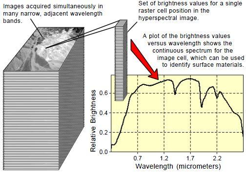
6 Hyperspectral Imaging 6
7 Imaging Spectrometers 7 Hyperspectral images are produced by instruments called imaging spectrometers. The development of these complex sensors has involved the convergence of two related but distinct technologies: spectroscopy and the remote imaging of Earth and planetary surfaces. Spectroscopy is the study of light that is emitted by or reflected from materials and its variation in energy with wavelength. As applied to the field of optical remote sensing, spectroscopy deals with the spectrum of sunlight that is diffusely reflected (scattered) by materials at the Earth s surface
8 Imaging Spectrometers 8 Instruments called spectrometers (or spectroradiometers) are used to make ground-based or laboratory measurements of the light reflected from a test material. An optical dispersing element such as a grating or prism in the spectrometer splits this light into many narrow, adjacent wavelength bands and the energy in each band is measured by a separate detector. By using hundreds or even thousands of detectors, spectrometers can make spectral measurements of bands as narrow as 0.01 micrometers over a wide wavelength range, typically at least 0.4 to 2.4 micrometers (visible through middle infrared wavelength ranges).

9 List of Imaging Spectrometers 9
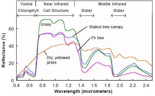
10 Spectral reflectance 10 In reflected-light spectroscopy the fundamental property that we want to obtain is spectral reflectance: the ratio of reflected energy to incident energy as a function of wavelength. Reflectance varies with wavelength for most materials because energy at certain wavelengths is scattered or absorbed to different degrees. The reflectance variations are evident when we compare spectral reflectance curves (plots of reflectance versus wavelength) for different materials

11 11 The overall shape of a spectral curve and the position and strength of absorption bands in many cases can be used to identify and discriminate different materials. For example, vegetation has higher reflectance in the near infrared range and lower reflectance of red light than soils.

12 Mineral Spectra 12 Plant Spectra
13 Spectral libraries 13 Several libraries of reflectance spectra of natural and man-made materials are available for public use. These libraries provide a source of reference spectra that can aid the interpretation of hyperspectral and multispectral images The ASTER spectral library currently contains nearly 2000 spectra, including minerals, rocks, soils, man-made materials, water, and snow. Many of the spectra cover the entire wavelength region from 0.4 to 14 μm. The library is accessible interactively via the Worldwide Web at USGS Spectral Library (The United States Geological Survey) Spectroscopy Lab in Denver, Colorado has compiled a library of about 500 reflectance spectra of minerals and a few plants over the wavelength range from 0.2 to 3.0 μm. This library is accessible online at
14 Spectra in spectral space 14 Spectral plots are an important tool to usewhen you explore a hyperspectral image. A reflectance spectrum consists of a set of reflectance values, one for each spectral channel (band). Each of these channels can be considered as one dimension in a hypothetical n-dimensional spectral space, where n is the number of spectral channels.

15 Spectral plot 15 A simple two-band example is shown. The designated point can also be treated mathematically as the end point of a vector that begins at the origin of the coordinate system. Spectra with the same shape but differing in overall reflectance plot as vectors with the same orientation but with endpoints at different distances from the origin. Shorter spectral vectors represent darker spectra and longer vectors represent brighter spectra.
16 Spectral plot 16 It may be difficult to visualize such a plot for an image involving more than three wavelength bands, but it is mathematically possible to construct a hyperdimensional spectral space defined by dozens or hundreds of mutually-perpendicular coordinate axes. Each spectrum being considered, occupies a position in this n-dimensional spectral space. Similarity between spectra can be judged by the relative closeness of these positions (spectral distance) or by how small the angle is between the spectral vectors.
17 Spatial resolution and mixed spectra 17 An imaging spectrometer makes spectral measurements of many small patches of the Earth s surface, each of which is represented as a pixel in the hyperspectral image. The size of the ground area represented by a single set of spectral measurements defines the spatial resolution of the image and depends on the sensor design and the height of the sensor above the surface NASA s Airborne Visible/Infrared Imaging Spectrometer (AVIRIS), for example, has a spatial resolution of 20 meters when flown at its typical altitude of 20 kilometers, but a 4- meter resolution when flown at an altitude of 4 kilometers.

18 Spatial resolution and mixed spectra 18 When the size of the ground resolution cell is large, it is more likely that more than one material contributes to an individual spectrum measured by the sensor The result is a composite or mixed spectrum, and the pure spectra that contribute to the mixture are called endmember spectra.
19 Linear and Non-linear mixing 19 Linear spectral mixing : Each reflected photon interacts with only one surface material. The energy reflected from the materials combines additively, so that each material s contribution to the composite spectrum is directly proportional to its area within the pixel. Non-linear mixing : In an intimate mixture, such as the microscopic mixture of mineral particles found in soils, a single photon interacts with more than one material. Such mixtures are nonlinear in character and therefore more difficult to unravel.
20 Spectral radiance characteristics 20 Apart from surface reflectance, the spectral radiance measured by a remote sensor depends on : The spectrum of the input solar energy Interactions of this energy during its downward and upward passages through the atmosphere The geometry of illumination for individual areas on the ground Characteristics of the sensor system. Effects : These factors not only affect our ability to retrieve accurate spectral reflectance values for ground features Introduce additional within-scene variability which hampers comparisons between individual image cells.
21 Strategies of Image Analysis 21 The difference in spectral information between two adjacent wavelength bands is typically very small and their grayscale images therefore appear nearly identical. Much of the data in a scene therefore would seem to be redundant, but embedded in it is critical information that often can be used to identify the ground surface materials. Dimension reduction methodologies : Principle Component Analysis (PCA) Kernel Principle Component Analysis (K-PCA) Independent Component Analysis (ICA) Projection Pursuit Gaussian distributed data Non-Gaussian distributed data
Hyperspectral Atmospheric Correction
 Hyperspectral Atmospheric Correction Bo-Cai Gao June 2015 Remote Sensing Division Naval Research Laboratory, Washington, DC USA BACKGROUND The concept of imaging spectroscopy, or hyperspectral imaging,
Spectroscopy - is the study of the interaction between matter and radiated energy.
 Spectroscopy www.oakland.edu/?id=171 www.d.umn.edu/~mharvey/co www.spinoff.nasa.gov/spinoff201 www.aerodata-surveys.com/data_processin www.loke.as.arizona.edu/~ckulesa/camp/spectroscop www.rgbstock.com/photo/milvggk/color+model+%28
Hyperspectral Data as a Tool for Mineral Exploration
 1 Hyperspectral Data as a Tool for Mineral Exploration Nahid Kavoosi, PhD candidate of remote sensing kavoosyn@yahoo.com Nahid Kavoosi Abstract In Geology a lot of minerals and rocks have characteristic
NASA s Airborne Visible/Infrared Imaging Spectrometer (AVIRIS) AVIRIS: PEARL HARBOR, HAWAII
 AVIRIS: PEARL HARBOR, HAWAII") AVIRIS: PEARL HARBOR, HAWAII 000412 NASA s Airborne Visible/Infrared Imaging Spectrometer (AVIRIS) LCLUC Update Robert O. Green (Tom Chrien, presenting) Jet Propulsion Laboratory Overview Objective & Approach
AVIRIS: PEARL HARBOR, HAWAII 000412 NASA s Airborne Visible/Infrared Imaging Spectrometer (AVIRIS) LCLUC Update Robert O. Green (Tom Chrien, presenting) Jet Propulsion Laboratory Overview Objective & Approach
Lunar Surface Material Composition Mapping
 Introduction: Lunar Surface Material Composition Mapping Japan, India, China, and the United States have recently sent spacecraft orbiters to study the lunar surface. The main focus of these missions has
Remote sensing and Reflectance spectroscopy as useful tools for Uranium exploration
 Remote sensing and Reflectance spectroscopy as useful tools for Uranium exploration Fares Howari, PhD University of Texas at Austin Bureau of Economic Geology (BEG) and Center for International Energy
Fundamentals of Remote Sensing
 Division of Spatial Information Science Graduate School Life and Environment Sciences University of Tsukuba Fundamentals of Remote Sensing Prof. Dr. Yuji Murayama Surantha Dassanayake 10/6/2010 1 Fundamentals
Making Accurate Field Spectral Reflectance Measurements By Dr. Alexander F. H. Goetz, Co-founder ASD Inc., Boulder, Colorado, 80301, USA October 2012
 Making Accurate Field Spectral Reflectance Measurements By Dr. Alexander F. H. Goetz, Co-founder ASD Inc., Boulder, Colorado, 80301, USA October 2012 Introduction Accurate field spectral reflectance measurements
Supporting Online Material for
 www.sciencemag.org/cgi/content/full/1178105/dc1 Supporting Online Material for Detection of Adsorbed Water and Hydroxyl on the Moon Roger N. Clark E-mail: rclark@usgs.gov This PDF file includes: Materials
PRINCIPLES OF REMOTE SENSING. Electromagnetic Energy and Spectral Signatures
 PRINCIPLES OF REMOTE SENSING Electromagnetic Energy and Spectral Signatures Remote sensing is the science and art of acquiring and analyzing information about objects or phenomena from a distance. As humans,
9/12/2011. Training Course Remote Sensing - Basic Theory & Image Processing Methods September 2011
 Training Course Remote Sensing - Basic Theory & Image Processing Methods 19 23 September 2011 Introduction to Remote Sensing Michiel Damen (September 2011) damen@itc.nl 1 Overview Electro Magnetic (EM)
HICO Science Mission Overview
 HICO Science Mission Overview Michael R. Corson* and Curtiss O. Davis** * Naval Research Laboratory Washington, DC corson@nrl.navy.mil ** College of Oceanic and Atmospheric Sciences Oregon State University
Illumination, Radiometry, and a (Very Brief) Introduction to the Physics of Remote Sensing!
 Introduction to the Physics of Remote Sensing!") Illumination, Radiometry, and a (Very Brief) Introduction to the Physics of Remote Sensing! Course Philosophy" Rendering! Computer graphics! Estimation! Computer vision! Robot vision" Remote sensing! lhm
Illumination, Radiometry, and a (Very Brief) Introduction to the Physics of Remote Sensing! Course Philosophy" Rendering! Computer graphics! Estimation! Computer vision! Robot vision" Remote sensing! lhm
Introduction to RS Lecture 2. NR401 Dr. Avik Bhattacharya 1
 Introduction to RS Lecture 2 NR401 Dr. Avik Bhattacharya 1 This course is about electromagnetic energy sensors other types of remote sensing such as geophysical will be disregarded. For proper analysis
UNIT I EMR AND ITS INTERACTION WITH ATMOSPHERE & EARTH MATERIAL
 Date deliverance : UNIT I EMR AND ITS INTERACTION WITH ATMOSPHERE & EARTH MATERIAL Definition remote sensing and its components Electromagnetic spectrum wavelength regions important to remote sensing Wave
EBS 566/666 Lecture 8: (i) Energy flow, (ii) food webs
 Energy flow, (ii) food webs") EBS 566/666 Lecture 8: (i) Energy flow, (ii) food webs Topics Light in the aquatic environment Energy transfer and food webs Algal bloom as seen from space (NASA) Feb 1, 2010 - EBS566/666 1 Requirements
EBS 566/666 Lecture 8: (i) Energy flow, (ii) food webs Topics Light in the aquatic environment Energy transfer and food webs Algal bloom as seen from space (NASA) Feb 1, 2010 - EBS566/666 1 Requirements
The Spectral Radiative Effects of Inhomogeneous Clouds and Aerosols
 The Spectral Radiative Effects of Inhomogeneous Clouds and Aerosols S. Schmidt, B. Kindel, & P. Pilewskie Laboratory for Atmospheric and Space Physics University of Colorado SORCE Science Meeting, 13-16
Lecture 2: principles of electromagnetic radiation
 Remote sensing for agricultural applications: principles and methods Lecture 2: principles of electromagnetic radiation Instructed by Prof. Tao Cheng Nanjing Agricultural University March Crop 11, Circles
HICO Calibration and Atmospheric Correction
 HICO Calibration and Atmospheric Correction Curtiss O. Davis College of Earth Ocean and Atmospheric Sciences Oregon State University, Corvallis, OR, USA 97331 cdavis@coas.oregonstate.edu Oregon State Introduction
Creation of hyper spectral library and lithological discrimination of granite rocks using SVCHR -1024: lab based approach
 OPEN JOURNAL SYSTEMS ISSN:2237-2202 Available on line at Directory of Open Access Journals Journal of Hyperspectral Remote Sensing v.7, n.3 (2017) 168-177 www.periodicos.ufpe.br/revistas/jhrs Journal of
Reflectivity in Remote Sensing
 Reflectivity in Remote Sensing The amount of absorbance and reflection of white light by a substance is dependent upon the molecular makeup of the substance. Humans have used dyes for years to obtain colors-
HISTORICAL PLASTER COMPOSITION DETECTION USING REFLECTANCE SPECTROSCOPY
 HISTORICAL PLASTER COMPOSITION DETECTION USING REFLECTANCE SPECTROSCOPY Eva Matoušková 1, Martina Hůlková 1 and Jaroslav Šedina 1 1 Czech Technical University in Prague, Faculty of Civil Engineering, Department
Learning Objectives. Thermal Remote Sensing. Thermal = Emitted Infrared
 November 2014 lava flow on Kilauea (USGS Volcano Observatory) (http://hvo.wr.usgs.gov) Landsat-based thermal change of Nisyros Island (volcanic) Thermal Remote Sensing Distinguishing materials on the ground
HICO OSU Website and Data Products
 HICO OSU Website and Data Products Curtiss O. Davis College of Earth Ocean and Atmospheric Sciences Oregon State University, Corvallis, OR, USA 97331 cdavis@coas.oregonstate.edu Oregon State Introduction
Spectral reflectance: When the solar radiation is incident upon the earth s surface, it is either
 Spectral reflectance: When the solar radiation is incident upon the earth s surface, it is either reflected by the surface, transmitted into the surface or absorbed and emitted by the surface. Remote sensing
A GLOBAL ANALYSIS OF URBAN REFLECTANCE. Christopher SMALL
 A GLOBAL ANALYSIS OF URBAN REFLECTANCE Christopher SMALL Lamont Doherty Earth Observatory Columbia University Palisades, NY 10964 USA small@ldeo.columbia.edu ABSTRACT Spectral characterization of urban
Lecture 4: Heat, and Radiation
 Lecture 4: Heat, and Radiation Heat Heat is a transfer of energy from one object to another. Heat makes things warmer. Heat is measured in units called calories. A calorie is the heat (energy) required
MULTICHANNEL NADIR SPECTROMETER FOR THEMATICALLY ORIENTED REMOTE SENSING INVESTIGATIONS
 S E S 2 5 Scientific Conference SPACE, ECOLOGY, SAFETY with International Participation 1 13 June 25, Varna, Bulgaria MULTICHANNEL NADIR SPECTROMETER FOR THEMATICALLY ORIENTED REMOTE SENSING INVESTIGATIONS
Coastal Characterization Using EO-1 Hyperion Data
 Coastal Characterization Using EO-1 Hyperion Data Dr. Hsiao-hua K. Burke EO-1 SVT Meeting 18-21 November 2002 Sponsor: NOAA NESDIS GOES 2002-1 Channel Positions of Various Ocean- Color Sensors, 1978-2000*
APAS Laboratory { PAGE } Spectroscopy SPECTROSCOPY
 SPECTROSCOPY SYNOPSIS: In this lab you will eplore different types of emission spectra, calibrate a spectrometer using the spectrum of a known element, and use your calibration to identify an unknown element.
A Quantitative and Comparative Analysis of Linear and Nonlinear Spectral Mixture Models Using Radial Basis Function Neural Networks
 2314 IEEE TRANSACTIONS ON GEOSCIENCE AND REMOTE SENSING, VOL. 39, NO. 8, AUGUST 2001 Pasadena, CA for the use of their data. They would also like to acknowledge the useful comments by one anonymous reviewer.
Mars Infrared Spectroscopy:
 Workshop Report Mars Infrared Spectroscopy: From Theory and the Laboratory to Field Observations Held at the Lunar and Planetary Institute June 2002 Motivation for the Workshop Recommended at June 1999
INTRODUCTION TO MICROWAVE REMOTE SENSING. Dr. A. Bhattacharya
 1 INTRODUCTION TO MICROWAVE REMOTE SENSING Dr. A. Bhattacharya Why Microwaves? More difficult than with optical imaging because the technology is more complicated and the image data recorded is more varied.
ESM 186 Environmental Remote Sensing and ESM 186 Lab Syllabus Winter 2012
 ESM 186 Environmental Remote Sensing and ESM 186 Lab Syllabus Winter 2012 Instructor: Susan Ustin (slustin@ucdavis.edu) Phone: 752-0621 Office: 233 Veihmeyer Hall and 115A, the Barn Office Hours: Tuesday
Environmental Remote Sensing GEOG 2021
 Environmental Remote Sensing GEOG 2021 Lecture 3 Spectral information in remote sensing Spectral Information 2 Outline Mechanisms of variations in reflectance Optical Microwave Visualisation/analysis Enhancements/transforms
Key words: Hyperspectral, imaging, object identification, urban, investigation
 URBAN SENSING BY HYPERSPECTRAL DATA Lanfen ZHENG, Qingxi TONG, Bing ZHANG, Xing LI, Jiangui LIU The Institute of Remote Sensing Applications, Chinese Academy of Sciences P. O. Box 9718, 100101, Beijing,
Alteration zone Mapping in the Meiduk and Sar Cheshmeh Porphyry Copper Mining Districts of Iran using Advanced Land Imager (ALI) Satellite Data
 Satellite Data") Alteration zone Mapping in the Meiduk and Sar Cheshmeh Porphyry Copper Mining Districts of Iran using Advanced Land Imager (ALI) Satellite Data Amin Beiranvand Pour*, Mazlan Hashim Geoscience and Digital
Alteration zone Mapping in the Meiduk and Sar Cheshmeh Porphyry Copper Mining Districts of Iran using Advanced Land Imager (ALI) Satellite Data Amin Beiranvand Pour*, Mazlan Hashim Geoscience and Digital
Lecture 4: Radiation Transfer
 Lecture 4: Radiation Transfer Spectrum of radiation Stefan-Boltzmann law Selective absorption and emission Reflection and scattering Remote sensing Importance of Radiation Transfer Virtually all the exchange
Lecture 5: Greenhouse Effect
 /30/2018 Lecture 5: Greenhouse Effect Global Energy Balance S/ * (1-A) terrestrial radiation cooling Solar radiation warming T S Global Temperature atmosphere Wien s Law Shortwave and Longwave Radiation
Monitoring Vegetation Growth of Spectrally Landsat Satellite Imagery ETM+ 7 & TM 5 for Western Region of Iraq by Using Remote Sensing Techniques.
 Monitoring Vegetation Growth of Spectrally Landsat Satellite Imagery ETM+ 7 & TM 5 for Western Region of Iraq by Using Remote Sensing Techniques. Fouad K. Mashee, Ahmed A. Zaeen & Gheidaa S. Hadi Remote
Optical Theory Basics - 1 Radiative transfer
 Optical Theory Basics - 1 Radiative transfer Jose Moreno 3 September 2007, Lecture D1Lb1 OPTICAL THEORY-FUNDAMENTALS (1) Radiation laws: definitions and nomenclature Sources of radiation in natural environment
Fri. Apr. 14, Hewson paper: Geological Map using ASTER data Sabins Ch. 10 Oil Exploration Overview. Reading:
 Fri. Apr. 14, 2018 Hewson paper: Geological Map using ASTER data Sabins Ch. 10 Oil Exploration Overview Reading: Skim Sabins Chapter 10. Oil Exploration 1 Hewson et al. Objectives 1. 2. 3. 4. 5. 6. 7.
Lecture 5: Greenhouse Effect
 Lecture 5: Greenhouse Effect S/4 * (1-A) T A 4 T S 4 T A 4 Wien s Law Shortwave and Longwave Radiation Selected Absorption Greenhouse Effect Global Energy Balance terrestrial radiation cooling Solar radiation
This watermark does not appear in the registered version - Laser- Tissue Interaction
 S S d Laser- Tissue Interaction Types of radiation ionizing radiation Non - ionizing radiation You may click on any of the types of radiation for more detail about its particular type of interaction
1 University of Portland Portland OR
 Effect Of -To-Reflectance Transformation And Atmosphere Removal On Maximum ikelihood Classification Accuracy Of High-Dimensional Remote Sensing Data Joseph P. Hoffbeck and David A. andgrebe 2 University
9 Reflectance Spectroscopy
 Name: Date: 9 Reflectance Spectroscopy 9.1 Introduction With this lab, we will look at the wavelength dependence of the visible reflectance of various objects, and learn what this can tell us about the
Atmospheric Radiation
 Atmospheric Radiation NASA photo gallery Introduction The major source of earth is the sun. The sun transfer energy through the earth by radiated electromagnetic wave. In vacuum, electromagnetic waves
Many of remote sensing techniques are generic in nature and may be applied to a variety of vegetated landscapes, including
 Remote Sensing of Vegetation Many of remote sensing techniques are generic in nature and may be applied to a variety of vegetated landscapes, including 1. Agriculture 2. Forest 3. Rangeland 4. Wetland,
Extraction of incident irradiance from LWIR hyperspectral imagery
 DRDC-RDDC-215-P14 Extraction of incident irradiance from LWIR hyperspectral imagery Pierre Lahaie, DRDC Valcartier 2459 De la Bravoure Road, Quebec, Qc, Canada ABSTRACT The atmospheric correction of thermal
PAPER No. 12: ORGANIC SPECTROSCOPY MODULE No. 7: Instrumentation for IR spectroscopy
 KNOW MORE Web links https://en.wikipedia.org/wiki/infrared_ http://hiq.lindegas.com/en/analytical_methods/infrared_/non_dispersive_infrared.html http://blamp.sites.truman.edu/files/2012/11/322-ir-and-ftir.pdf
What is a vegetation index?
 Vegetation indexes What is a vegetation index? A tool: a vegetation index is a mathematical formula used to estimate the likelihood of vegetation presence in remotely sensed data A product: the result
SOIL MINERALOGY ANOMALY DETECTION IN DIXIE VALLEY, NEVADA USING HYPERSPECTRAL DATA
 PROCEEDINGS: Twenty-Seventh Workshop on Geothermal Reservoir Engineering Stanford University, Stanford, California, January 28-30, 2002 SGP-TR-171 SOIL MINERALOGY ANOMALY DETECTION IN DIXIE VALLEY, NEVADA
Spectrum of Radiation. Importance of Radiation Transfer. Radiation Intensity and Wavelength. Lecture 3: Atmospheric Radiative Transfer and Climate
 Lecture 3: Atmospheric Radiative Transfer and Climate Radiation Intensity and Wavelength frequency Planck s constant Solar and infrared radiation selective absorption and emission Selective absorption
Field Emissivity Measurements during the ReSeDA Experiment
 Field Emissivity Measurements during the ReSeDA Experiment C. Coll, V. Caselles, E. Rubio, E. Valor and F. Sospedra Department of Thermodynamics, Faculty of Physics, University of Valencia, C/ Dr. Moliner
1. The most important aspects of the quantum theory.
 Lecture 5. Radiation and energy. Objectives: 1. The most important aspects of the quantum theory: atom, subatomic particles, atomic number, mass number, atomic mass, isotopes, simplified atomic diagrams,
The Fundamentals of Spectroscopy: Theory BUILDING BETTER SCIENCE AGILENT AND YOU
 The Fundamentals of Spectroscopy: Theory BUILDING BETTER SCIENCE AGILENT AND YOU 1 Agilent is committed to the educational community and is willing to provide access to company-owned material. This slide
Lecture 3: Atmospheric Radiative Transfer and Climate
 Lecture 3: Atmospheric Radiative Transfer and Climate Solar and infrared radiation selective absorption and emission Selective absorption and emission Cloud and radiation Radiative-convective equilibrium
AS 101: Day Lab #2 Summer Spectroscopy
 Spectroscopy Goals To see light dispersed into its constituent colors To study how temperature, light intensity, and light color are related To see spectral lines from different elements in emission and
Advanced Spectroscopy Laboratory
 Advanced Spectroscopy Laboratory - Raman Spectroscopy - Emission Spectroscopy - Absorption Spectroscopy - Raman Microscopy - Hyperspectral Imaging Spectroscopy FERGIELAB TM Raman Spectroscopy Absorption
HEAVY MINERALS INVESTIGATION USING GEOSPATIAL TECHNOLOGY
 HEAVY MINERALS INVESTIGATION USING GEOSPATIAL TECHNOLOGY *Muthiah.M.S, **Colins Johnny.J, *PG student: Department of Civil Engineering, Anna University Regional Campus Tirunelveli, India **Assistant Professor:
Thermal Infrared (TIR) Remote Sensing: Challenges in Hot Spot Detection
 Remote Sensing: Challenges in Hot Spot Detection") Thermal Infrared (TIR) Remote Sensing: Challenges in Hot Spot Detection ASF Seminar Series Anupma Prakash Day : Tuesday Date : March 9, 2004 Time : 2.00 pm to 2.30 pm Place : GI Auditorium Geophysical
Thermal Infrared (TIR) Remote Sensing: Challenges in Hot Spot Detection ASF Seminar Series Anupma Prakash Day : Tuesday Date : March 9, 2004 Time : 2.00 pm to 2.30 pm Place : GI Auditorium Geophysical
HYPERSPECTRAL MAPPING OF ALTERATION IN HALEMA UMA U CRATER AND KILAUEA CALDERA
 HYPERSPECTRAL MAPPING OF ALTERATION IN HALEMA UMA U CRATER AND KILAUEA CALDERA Geoffrey M. Rehders Department of Geology University of Hawai i at Hilo Hilo, HI 96720 ABSTRACT AVIRIS hyperspectral imagery
SATELLITE REMOTE SENSING
 SATELLITE REMOTE SENSING of NATURAL RESOURCES David L. Verbyla LEWIS PUBLISHERS Boca Raton New York London Tokyo Contents CHAPTER 1. SATELLITE IMAGES 1 Raster Image Data 2 Remote Sensing Detectors 2 Analog
Detection of Adsorbed Water and Hydroxyl on the Moon
 Detection of Adsorbed Water and Hydroxyl on the Moon Roger N. Clark U. S. Geological Survey, MS 964, Box 25046 Federal Center, Denver CO 80227, USA. E-mail: rclark@usgs.gov Data from the Visual and Infrared
THE UTILITY OF HYPERSPECTRAL DATA ON EXPLORATION OF SANDSTONE-HOSTED URANIUM DEPOSITS *
 THE UTILITY OF HYPERSPECTRAL DATA ON EXPLORATION OF SANDSTONE-HOSTED URANIUM DEPOSITS * Jie-lin Zhang Beijing Research Institute of Uranium Geology Key Laboratory of Remote Sensing Beijing 100029, China,
The Spectrophotometer and Atomic Spectra of Hydrogen Physics 246
 The Spectrophotometer and Atomic Spectra of Hydrogen Physics 46 Introduction: When heated sufficiently, most elements emit light. With a spectrometer, the emitted light can be broken down into its various
Figure S1. CRISM maps of modeled mineralogy projected over CTX imagery (same
 GSA DATA REPOSITORY 2015222 Cannon and Mustard Additional examples Figure S1. CRISM maps of modeled mineralogy projected over CTX imagery (same parameters as Figure 1). A: Taytay Crater (CRISM ID: HRL00005B77).
What are Aerosols? Suspension of very small solid particles or liquid droplets Radii typically in the range of 10nm to
 What are Aerosols? Suspension of very small solid particles or liquid droplets Radii typically in the range of 10nm to 10µm Concentrations decrease exponentially with height N(z) = N(0)exp(-z/H) Long-lived
Thermal And Near infrared Sensor for carbon Observation (TANSO) On board the Greenhouse gases Observing SATellite (GOSAT) Research Announcement
 On board the Greenhouse gases Observing SATellite (GOSAT) Research Announcement") Thermal And Near infrared Sensor for carbon Observation (TANSO) On board the Greenhouse gases Observing SATellite (GOSAT) Research Announcement Appendix A Outlines of GOSAT and TANSO Sensor GOSAT (Greenhouse
Thermal And Near infrared Sensor for carbon Observation (TANSO) On board the Greenhouse gases Observing SATellite (GOSAT) Research Announcement Appendix A Outlines of GOSAT and TANSO Sensor GOSAT (Greenhouse
Principles of Satellite Remote Sensing
 Chapter 5 Principles of Satellite Remote Sensing Goal: Give a overview on the characteristics of satellite remote sensing. Satellites have several unique characteristics which make them particularly useful
Analysing Land Surface Emissivity with Multispectral Thermal Infrared Data
 2nd Workshop on Remote Sensing and Modeling of Surface Properties 9-11 June 2009, Météo France, Toulouse, France Analysing Land Surface Emissivity with Multispectral Thermal Infrared Data Maria Mira, Thomas
Airborne Thermal Infrared Hyperspectral Imaging for Mineral Mapping
 Airborne Thermal Infrared Hyperspectral Imaging for Mineral Mapping Minerals such as silicates, aluminosilicates (feldspar), magnesium silicates (serpentine) and olivines are among the most commonly encountered
Chapter 4 Nadir looking UV measurement. Part-I: Theory and algorithm
 Chapter 4 Nadir looking UV measurement. Part-I: Theory and algorithm -Aerosol and tropospheric ozone retrieval method using continuous UV spectra- Atmospheric composition measurements from satellites are
DAY LABORATORY EXERCISE: SPECTROSCOPY
 AS101 - Day Laboratory: Spectroscopy Page 1 DAY LABORATORY EXERCISE: SPECTROSCOPY Goals: To see light dispersed into its constituent colors To study how temperature, light intensity, and light color are
GNR401 Principles of Satellite Image Processing
 Principles of Satellite Image Processing Instructor: Prof. CSRE, IIT Bombay bkmohan@csre.iitb.ac.in Slot 5 Guest Lecture PCT and Band Arithmetic November 07, 2012 9.30 AM 10.55 AM IIT Bombay Slide 1 November
Mineral Mapping with AVIRIS and EO-1 Hyperion **
 Mineral Mapping with AVIRIS and EO-1 Hyperion ** Fred A. Kruse 1 1.0 Introduction Imaging Spectrometry data or Hyperspectral Imagery (HSI) acquired using airborne systems have been used in the geologic
Radiation in the atmosphere
 Radiation in the atmosphere Flux and intensity Blackbody radiation in a nutshell Solar constant Interaction of radiation with matter Absorption of solar radiation Scattering Radiative transfer Irradiance
Summary. Week 7: 10/5 & 10/ Learning from Light. What are the three basic types of spectra? Three Types of Spectra
 Week 7: 10/5 & 10/7 Capturing that radiation Chapter 6 (Telescopes & Sensors) Optical to Radio Summary What are we sensing? Matter! Matter is made of atoms (nucleus w/ protons, neutrons & cloud of electrons
ASTRO Fall 2012 LAB #7: The Electromagnetic Spectrum
 ASTRO 1050 - Fall 2012 LAB #7: The Electromagnetic Spectrum ABSTRACT Astronomers rely on light to convey almost all of the information we have on distant astronomical objects. In addition to measuring
1 Lecture, 2 September 1999
 1 Lecture, 2 September 1999 1.1 Observational astronomy Virtually all of our knowledge of astronomical objects was gained by observation of their light. We know how to make many kinds of detailed measurements
Chapter 4. Spectroscopy. Dr. Tariq Al-Abdullah
 Chapter 4 Spectroscopy Dr. Tariq Al-Abdullah Learning Goals: 4.1 Spectral Lines 4.2 Atoms and Radiation 4.3 Formation of the Spectral Lines 4.4 Molecules 4.5 Spectral Line Analysis 2 DR. T. AL-ABDULLAH
LIDAR. Natali Kuzkova Ph.D. seminar February 24, 2015
 LIDAR Natali Kuzkova Ph.D. seminar February 24, 2015 What is LIDAR? Lidar (Light Detection And Ranging) is an optical remote sensing technology that measures distance by illuminating a target with a laser
Atmospheric Compensation and Surface Temperature and Emissivity Retrieval with LWIR Hyperspectral Imagery
 Atmospheric Compensation and Surface Temperature and Emissivity Retrieval with LWIR Hyperspectral Imagery A Dissertation Presented by Michael Pieper to The Department of Electrical and Computer Engineering
Lecture 26. Regional radiative effects due to anthropogenic aerosols. Part 2. Haze and visibility.
 Lecture 26. Regional radiative effects due to anthropogenic aerosols. Part 2. Haze and visibility. Objectives: 1. Attenuation of atmospheric radiation by particulates. 2. Haze and Visibility. Readings:
INTRODUCTION TO MICROWAVE REMOTE SENSING - II. Dr. A. Bhattacharya
 1 INTRODUCTION TO MICROWAVE REMOTE SENSING - II Dr. A. Bhattacharya The Radiation Framework The information about features on the Earth s surface using RS depends on measuring energy emanating from the
Remote Sensing How we know what we know A Brief Tour
 Remote Sensing How we know what we know A Brief Tour Dr. Erik Richard Dr. Jerald Harder LASP Richard 1 Remote Sensing The measurement of physical variables (usually light or sound) from outside of a medium
Lesson 4b Remote Sensing and geospatial analysis to integrate observations over larger scales
 Lesson 4b Remote Sensing and geospatial analysis to integrate observations over larger scales We have discussed static sensors, human-based (participatory) sensing, and mobile sensing Remote sensing: Satellite
Remote Sensing, Computers, and Land Use Planning
 Purdue University Purdue e-pubs LARS Technical Reports Laboratory for Applications of Remote Sensing 1-1-1973 Remote Sensing, Computers, and Land Use Planning Harry C. Hitchcock Follow this and additional
NASA-led campaign studies Hawaii's iconic volcanoes 9 February 2017, by Alan Buis
 NASA-led campaign studies Hawaii's iconic volcanoes 9 February 2017, by Alan Buis Night view of Hawaii's Kilauea Volcano, one of Earth's most active volcanoes. A NASA-led team is studying Hawaiian volcanoes
Topics: Visible & Infrared Measurement Principal Radiation and the Planck Function Infrared Radiative Transfer Equation
 Review of Remote Sensing Fundamentals Allen Huang Cooperative Institute for Meteorological Satellite Studies Space Science & Engineering Center University of Wisconsin-Madison, USA Topics: Visible & Infrared
LAB 3: SPECTROSCOPY. GEOL104: Exploring the Planets
 LAB 3: SPECTROSCOPY OBJECTIVES: I. Review the basics of spectroscopy, including how to identify different materials on the basis of spectra. II. Develop an understanding of general spectroscopic features
Hot Spot Signature Dynamics in Vegetation Canopies with varying LAI. F. Camacho-de Coca, M. A. Gilabert and J. Meliá
 Hot Spot Signature Dynamics in Vegetation Canopies with varying LAI F. Camacho-de Coca, M. A. Gilabert and J. Meliá Departamento de Termodinàmica. Facultat de Física. Universitat de València Dr. Moliner,
Lênio Soares Galvão Raimundo Almeida Filho Ícaro Vitorello
 Use of ASTER short-wave infrared bands for the spectral discrimination of hydrothermally altered-materials: evaluation in a tropical savannah environment Lênio Soares Galvão Raimundo Almeida Filho Ícaro
Lecture 19: Operational Remote Sensing in Visible, IR, and Microwave Channels
 MET 4994 Remote Sensing: Radar and Satellite Meteorology MET 5994 Remote Sensing in Meteorology Lecture 19: Operational Remote Sensing in Visible, IR, and Microwave Channels Before you use data from any
Sparse Representation-based Analysis of Hyperspectral Remote Sensing Data
 Sparse Representation-based Analysis of Hyperspectral Remote Sensing Data Ribana Roscher Institute of Geodesy and Geoinformation Remote Sensing Group, University of Bonn 1 Remote Sensing Image Data Remote
hf = E 1 - E 2 hc = E 1 - E 2 λ FXA 2008 Candidates should be able to : EMISSION LINE SPECTRA
 1 Candidates should be able to : EMISSION LINE SPECTRA Explain how spectral lines are evidence for the existence of discrete energy levels in isolated atoms (i.e. in a gas discharge lamp). Describe the
Astronomical Techniques
 Astronomers use different techniques to extract information from the light that they detect with detectors Celestial objects emit light (different wavelengths) Telescopes are used to see these distant
ABB Remote Sensing Atmospheric Emitted Radiance Interferometer AERI system overview. Applications
 The ABB Atmospheric Emitted Radiance Interferometer AERI provides thermodynamic profiling, trace gas detection, atmospheric cloud aerosol study, air quality monitoring, and more. AERI high level overview
Drought Estimation Maps by Means of Multidate Landsat Fused Images
 Remote Sensing for Science, Education, Rainer Reuter (Editor) and Natural and Cultural Heritage EARSeL, 2010 Drought Estimation Maps by Means of Multidate Landsat Fused Images Diego RENZA, Estíbaliz MARTINEZ,
Multiresolution Analysis of Urban Reflectance
 Multiresolution Analysis of Urban Reflectance Christopher Small Lamont Doherty Earth Observatory Columbia University Palisades, NY 10964 USA small@ldeo.columbia.edu Reprinted from: IEEE/ISPRS joint Workshop