GEOGG141 Principles & Practice of Remote Sensing (PPRS) RADAR III: Applications Revision
|
|
|
- Primrose Hopkins
- 5 years ago
- Views:
Transcription
1 UCL DEPARTMENT OF GEOGRAPHY GEOGG141 Principles & Practice of Remote Sensing (PPRS) RADAR III: Applications Revision Dr. Mathias (Mat) Disney UCL Geography Office: 113, Pearson Building Tel:
2 RECAP
3
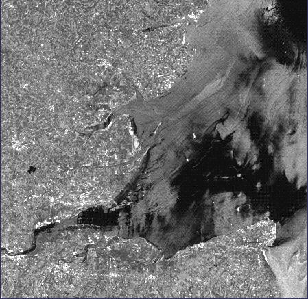
4 Observations of forests... C-band (cm-tens of cm) low penetration depth, leaves / needles / twigs L-band leaves / branches P-band can propagate through canopy to branches, trunk and ground C-band quickly saturates (even at relatively low biomass, it only sees canopy); P-band maintains sensitivity to higher biomass as it sees trunks, branches, etc Low biomass behaviour dictated by ground properties
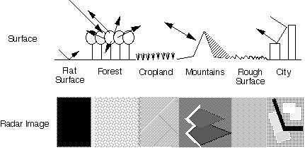
5 Surfaces - scattering depends on moisture and roughness Note - we could get penetration into soils at longer wavelengths or with dry soils (sand) Surfaces are typically bright if wet and rough dark if dry and smooth What happens if a dry rough surface becomes wet? Note similar arguments apply to snow or ice surfaces. Note also, always need to remember that when vegetation is present, it can act as the dominant scatterer OR as an attenuator (of the ground scattering)

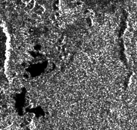
6 Eastern Sahara desert Landsat SIR-A Penetration 1 4 m

7 Safsaf oasis, Egypt Penetration up to 2 m Landsat SIR-C L-band 16 April 1994
8 Single channel data Many applications are based on the operationally-available spaceborne SARs, all of which are single channel (ERS, Radarsat, JERS) As these are spaceborne datasets, we often encounter multitemporal applications (which is fortunate as these are only single-channel instruments!) When thinking about applications, think carefully about where the information is:- scattering physics spatial information (texture, ) temporal changes
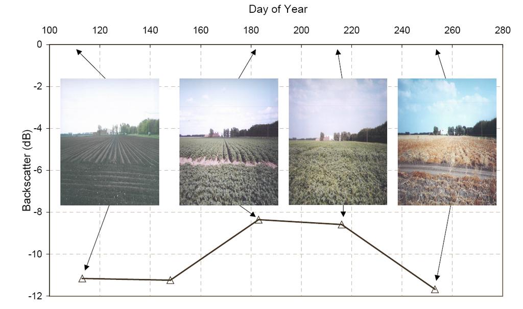
9
10 Multi-temporal data Temporal changes in the physical properties of regions in the image offer another degree of freedom for distinguishing them but only if these changes can actually be seen by the radar for example - ERS-1 and ERS-2:- wetlands, floods, snow cover, crops implications for mission design? ALOS-PALSAR ( ) revisits


11 Wetlands in Vietnam - ERS Oct 97 Jan Mar May 99 Sept 99 Dec 99 Jan 00 Feb 00

12 Wetlands...

13 SIR-C (mission 1 left, mission 2 centre, difference in blue on right)

14 Floods... Maastricht A two date composite of ERS SAR images 30/1/95 (red/green) 21/9/95 (blue)

15 Snow cover... Glen Tilt - Blair Atholl ERS-2 composite red = 25/11/96 cyan=19/5/97 Scott Polar Research Institute

16 Agriculture " Gt. Driffield Composite of 3 ERS SAR images from different dates


17 OSR - Oil seed rape WW - Winter wheat

18 ERS SAR East Anglia
19
20

21 Radar modelling Surface roughness Volume roughness Dielectric constant ~ moisture Models of the vegetation volume, e.g. water cloud model of Attema and Ulaby, RT2 model of Saich Multitemporal SHAC radar image Barton Bendish
22 Water cloud model σ , * ( () & 2BL # & 2BL # $! = % cosθ " θ Acosθ 1 exp + ( ) $! % cos C + Dm.exp " s A vegetation canopy backscatter at full cover B canopy attenuation coefficient C dry soil backscatter D sensitivity to soil moisture σ 0 = scattering coefficient m s = soil moisture θ = incidence angle L = leaf area index Vegetation
23 Values of A, B, C, D Parameter Value Units / description A db B Fractional canopy moisture C db D Fractional soil moisture
24 Simulated backscatter Actual backscatter (db) r 2 = 0.81 r 2 = 0.81 σ , * ( () & 2BL # $! % cos ( C + Dm ).exp " & 2BL # $! = % cosθ " θ Acosθ 1 exp + s CHIPS simulated backscatter (db)
25
26
27
28 Canopy moisture 1 Simulated fractional canopy moisture r 2 = 0.96 r 2 = Measured fractional canopy moisture


29 Applications Irrigation fraud detection Irrigation scheduling Crop status mapping, e.g. disease, water stress
30 Multi-parameter radar More sophisticated instruments have multi-frequency, multi-polarisation radars, with steerable beams (different incidence angle) Also, different modes combinations of resolutions and swath widths SIR-C / X-SAR ENVISAT ASAR, ALOS PALSAR,...
 C-total power (green) X-VV")
31 Flevoland April 1994 (SIR-C/X-SAR) (L/C/X composite) L-total power (red) C-total power (green) X-VV (blue)
")
32 Thetford, UK AIRSAR (1991) C-HH
 multi-freq")
33 Thetford, UK AIRSAR (1991) multi-freq composite
 combine detailed structural models with optical AND RADAR models to simulate signal in both domains http://www.sciencedirect.")
34 Coherent RADAR modelling Thetford, UK SHAC (SAR and Hyperspectral Airborne Campaign) neodc.nerc.ac.uk ATOM dataent _ Disney et al. (2006) combine detailed structural models with optical AND RADAR models to simulate signal in both domains Drat optical model + CASM (Coherent Additive Scattering Model) of Saich et al. (2001)
 combine detailed structural models with optical AND RADAR models to simulate signal in both domains http://www.sciencedirect.")
35 Coherent RADAR modelling Thetford, UK SHAC (SAR and Hyperspectral Airborne Campaign) neodc.nerc.ac.uk ATOM dataent _ Disney et al. (2006) combine detailed structural models with optical AND RADAR models to simulate signal in both domains Drat optical model + CASM (Coherent Additive Scattering Model) of Saich et al. (2001)
36 Optical signal with age for different tree density (HyMAP optical data)
37 Coherent (polarised) modelled RADAR signal (CASM)
38 OPTICAL RADAR
39 An ambitious list of Applications... Flood mapping, Snow mapping, Oil Slicks Sea ice type, Crop classification, Forest biomass / timber estimation, tree height Soil moisture mapping, soil roughness mapping / monitoring Pipeline integrity Wave strength for oil platforms Crop yield, crop stress Flood prediction Landslide prediction

40 CONCLUSIONS ALOS (RIP) Radar is very reliable because of cloud penetration and day/ night availability Major advances in interferometric SAR Should radar be used separately or as an adjunct to optical Earth observation data?
41 Revision Exam: 3 hrs, answer 4 from 7 (2 from Dietmar, 5 from me) Types of question based on PREVIOUS material be similar each year (not surprisingly!) Planck function, orbital calculations, definitions of terms, preprocessing stages Factors controlling measured signal from vegetation across vis/ SWIR, or angular behaviour RADAR principles eg RADAR equation, resolutions Principles of SAR interferometry and applications General questions - systems to address a given problem KEY: address that problem Does Q give scope for moving beyond one platform or wavelength? If so then DO SO
42 Revision Types of question based on NEW material for 2011 LiDAR Principles of lidar remote sensing? What is it good for and limitations? Example applications Radiative Transfer modelling Basis of RT model building blocks? Structure, leaf scattering, soil scattering Scalar RT equation what do terms mean? How can we go about solving?
43 Revision problems: Planck s Law Fractional energy from 0 to λ F 0 λ? Integrate Planck function Note E bλ (λ,t), emissive power of bbody at λ, is function of product λt only, so... Radiant energy from 0 to λ F 0 λ ( λ, T ) E 0 λ = σt ( λ, T ) 4 = λt 0 d ( λ, T ) E bλ ( λ, T ) σt 5 Total radiant energy for λ =0 to λ = 43
44 Revision: Planck s Law example Q: what fraction of the total power radiated by a black body at 5770 K fall, in the UV (0 < λ 0.38µm)? Need table of integral values of F 0 λ So, λt = 0.38µm * 5770K = 2193µmK Or 2.193x10 3 µmk i.e. between 2 and 3 Interpolate between F 0 λ (2x10 3 ) and F 0 λ (3x10 3 ) F F F 3 ( λ, T ) F0 0.38( 2x10 ) 3 3 ( 3x10 ) F ( 2x10 ) = = ( λ, T ) = Finally, F = 0.193*( ) = 0.11 i.e. ~11% of total solar energy lies in UV between 0 and 0.38µm λ T ( µ mk x10 3 ) F 0 λ ( λ T) (dimensionless)
45 Orbital period for a given instrument and height? Gravitational force F g = GM E m s /R se 2 where G is universal gravitational constant (6.67x10⁻¹¹ Nm 2 kg 2 ); M E is Earth mass (5.983x10 24 kg); m s is satellite mass (?) and R se is distance from Earth centre to satellite i.e. 6.38x h where h is satellite altitude Centripetal (not centrifugal!) force F c = m s v s2 /R se where v s is linear speed of satellite (=ω s R se where ω is the satellite angular velocity, rad s -1 ) for stable (constant radius) orbit F c = F g GM E m s /R se 2 = m s v s2 /R se = m s ω s2 R se 2 /R se so ω s 2 = GM E /R se 3 Orbits: examples From: 45
46 Orbits: examples Orbital period T of satellite (in s) = 2π/ω (remember 2π = one full rotation, 360, in radians) and R se = R E + h where R E = 6.38x10 6 m So now T = 2π[(R E +h) 3 /GM E ] 1/2 Example: geostationary altitude? T =?? Rearranging: h = [(GM E /4π 2 )T 2 ] 1/3 - R E So h = [(6.67x10-11 *5.983x10 24 /4π 2 )(24*60*60) 2 ] 1/3-6.38x10 6 h = 42.2x x10 6 = 35.8km 46
47 Example: polar orbiter period, if h = 705x10 3 m T = 2π[(6.38x x10 3 ) 3 / (6.67x10-11 *5.983x10 24 )] 1/2 T = s = 98.8mins Orbits: examples Example: show separation of successive ground tracks ~3000km Earth angular rotation = 2π/24*60*60 = 7.27x10⁻⁵ rads s -1 So in 98.8 mins, point on surface moves 98.8*60*7.27x10-5 =.431 rads Remember l =r*θ for arc of circle radius r & θ in radians So l = (Earth radius + sat. altitude)* θ = (6.38x x10 3 )* = 3054km 47
Microwave Remote Sensing of Soil Moisture. Y.S. Rao CSRE, IIT, Bombay
 Microwave Remote Sensing of Soil Moisture Y.S. Rao CSRE, IIT, Bombay Soil Moisture (SM) Agriculture Hydrology Meteorology Measurement Techniques Survey of methods for soil moisture determination, Water
RADAR Remote Sensing Application Examples
 RADAR Remote Sensing Application Examples! All-weather capability: Microwave penetrates clouds! Construction of short-interval time series through cloud cover - crop-growth cycle! Roughness - Land cover,
CEGE046 / GEOG3051 Principles & Practice of Remote Sensing (PPRS) 2: Radiation (i)
 2: Radiation (i)") CEGE046 / GEOG3051 Principles & Practice of Remote Sensing (PPRS) 2: Radiation (i) Dr. Mathias (Mat) Disney UCL Geography Office: 113, Pearson Building Tel: 7679 0592 Email: mdisney@ucl.geog.ac.uk www.geog.ucl.ac.uk/~mdisney
CEGE046 / GEOG3051 Principles & Practice of Remote Sensing (PPRS) 2: Radiation (i) Dr. Mathias (Mat) Disney UCL Geography Office: 113, Pearson Building Tel: 7679 0592 Email: mdisney@ucl.geog.ac.uk www.geog.ucl.ac.uk/~mdisney
Model based forest height estimation with ALOS/PalSAR: A first study.
 Model based forest height estimation with ALOS/PalSAR: A first study. K.P. Papathanassiou*, I. Hajnsek*, T.Mette*, S.R. Cloude** and A. Moreira* * (DLR) (DLR-HR) Oberpfaffenhofen, Germany ** AEL Consultants
Making a case for full-polarimetric radar remote sensing
 Making a case for full-polarimetric radar remote sensing Jeremy Nicoll Alaska Satellite Facility, University of Alaska Fairbanks 1 Polarization States of a Coherent Plane Wave electric field vector vertically
ERS-ENVISAT CROSS-INTERFEROMETRY SIGNATURES OVER DESERTS. Urs Wegmüller, Maurizio Santoro and Christian Mätzler
 ERS-ENVISAT CROSS-INTERFEROMETRY SIGNATURES OVER DESERTS Urs Wegmüller, Maurizio Santoro and Christian Mätzler Gamma Remote Sensing AG, Worbstrasse 225, CH-3073 Gümligen, Switzerland, http://www.gamma-rs.ch,
CHAPTER-7 INTERFEROMETRIC ANALYSIS OF SPACEBORNE ENVISAT-ASAR DATA FOR VEGETATION CLASSIFICATION
 147 CHAPTER-7 INTERFEROMETRIC ANALYSIS OF SPACEBORNE ENVISAT-ASAR DATA FOR VEGETATION CLASSIFICATION 7.1 INTRODUCTION: Interferometric synthetic aperture radar (InSAR) is a rapidly evolving SAR remote
Examination Questions & Model Answers (2009/2010) PLEASE PREPARE YOUR QUESTIONS AND ANSWERS BY USING THE FOLLOWING GUIDELINES;
 PLEASE PREPARE YOUR QUESTIONS AND ANSWERS BY USING THE FOLLOWING GUIDELINES;") Examination s & Model Answers (2009/2010) PLEASE PREPARE YOUR QUESTIONS AND ANSWERS BY USING THE FOLLOWING GUIDELINES; 1. If using option 2 or 3 use template provided 2. Use Times New Roman 12 3. Enter
Examination s & Model Answers (2009/2010) PLEASE PREPARE YOUR QUESTIONS AND ANSWERS BY USING THE FOLLOWING GUIDELINES; 1. If using option 2 or 3 use template provided 2. Use Times New Roman 12 3. Enter
DLR s TerraSAR-X contributes to international fleet of radar satellites to map the Arctic and Antarctica
 DLR s TerraSAR-X contributes to international fleet of radar satellites to map the Arctic and Antarctica The polar regions play an important role in the Earth system. The snow and ice covered ocean and
The Importance of Microwave Remote Sensing for Operational Sea Ice Services And Challenges
 The Importance of Microwave Remote Sensing for Operational Sea Ice Services And Challenges Wolfgang Dierking January 2015 (1) Why is microwave remote sensing important (=useful) for sea ice mapping? Problems
Snow property extraction based on polarimetry and differential SAR interferometry
 Snow property extraction based on polarimetry and differential SAR interferometry S. Leinß, I. Hajnsek Earth Observation and Remote Sensing, Institute of Enviromental Science, ETH Zürich TerraSAR X and
Microwave emissivity of land surfaces: experiments and models
 Microwave emissivity of land surfaces: experiments and models M. Brogioni, G.Macelloni, S.Paloscia, P.Pampaloni, S.Pettinato, E.Santi IFAC-CNR Florence, Italy Introduction Experimental investigations conducted
III. Publication III. c 2004 Authors
 III Publication III J-P. Kärnä, J. Pulliainen, K. Luojus, N. Patrikainen, M. Hallikainen, S. Metsämäki, and M. Huttunen. 2004. Mapping of snow covered area using combined SAR and optical data. In: Proceedings
Current Status of the ALOS-2 Operation and PALSAR-2 Calibration Activities
 Current Status of the ALOS-2 Operation and PALSAR-2 Calibration Activities Takeshi Motohka, Ryo Natsuaki, Yukihiro Kankaku, Shinichi Suzuki, Masanobu Shimada (JAXA) Osamu Isoguchi (RESTEC) CEOS SAR CALVAL
Earth Exploration-Satellite Service (EESS)- Active Spaceborne Remote Sensing and Operations
- Active Spaceborne Remote Sensing and Operations") Earth Exploration-Satellite Service (EESS)- Active Spaceborne Remote Sensing and Operations SRTM Radarsat JASON Seawinds TRMM Cloudsat Bryan Huneycutt (USA) Charles Wende (USA) WMO, Geneva, Switzerland
Earth Exploration-Satellite Service (EESS)- Active Spaceborne Remote Sensing and Operations SRTM Radarsat JASON Seawinds TRMM Cloudsat Bryan Huneycutt (USA) Charles Wende (USA) WMO, Geneva, Switzerland
Remote Sensing of Snow GEOG 454 / 654
 Remote Sensing of Snow GEOG 454 / 654 What crysopheric questions can RS help to answer? 2 o Where is snow lying? (Snow-covered area or extent) o How much is there? o How rapidly is it melting? (Area, depth,
GEOG Lecture 8. Orbits, scale and trade-offs
 Environmental Remote Sensing GEOG 2021 Lecture 8 Orbits, scale and trade-offs Orbits revisit Orbits geostationary (36 000 km altitude) polar orbiting (200-1000 km altitude) Orbits revisit Orbits geostationary
EE/Ge 157 b. Week 2. Polarimetric Synthetic Aperture Radar (2)
") EE/Ge 157 b Week 2 Polarimetric Synthetic Aperture Radar (2) COORDINATE SYSTEMS All matrices and vectors shown in this package are measured using the backscatter alignment coordinate system. This system
EE/Ge 157 b Week 2 Polarimetric Synthetic Aperture Radar (2) COORDINATE SYSTEMS All matrices and vectors shown in this package are measured using the backscatter alignment coordinate system. This system
Many of remote sensing techniques are generic in nature and may be applied to a variety of vegetated landscapes, including
 Remote Sensing of Vegetation Many of remote sensing techniques are generic in nature and may be applied to a variety of vegetated landscapes, including 1. Agriculture 2. Forest 3. Rangeland 4. Wetland,
Multi-temporal archaeological and environmental prospection in Nasca (Peru) with ERS-1/2, ENVISAT and Sentinel-1A C-band SAR data
 with ERS-1/2, ENVISAT and Sentinel-1A C-band SAR data") 12-13 November 215 ESA-ESRIN, Frascati (Rome), Italy Day 1 Session: Historical Landscapes and Environmental Analysis Multi-temporal archaeological and environmental prospection in Nasca (Peru) with ERS-1/2,
12-13 November 215 ESA-ESRIN, Frascati (Rome), Italy Day 1 Session: Historical Landscapes and Environmental Analysis Multi-temporal archaeological and environmental prospection in Nasca (Peru) with ERS-1/2,
Remote Sensing I: Basics
 Remote Sensing I: Basics Kelly M. Brunt Earth System Science Interdisciplinary Center, University of Maryland Cryospheric Science Laboratory, Goddard Space Flight Center kelly.m.brunt@nasa.gov (Based on
SNOW COVER MONITORING IN ALPINE REGIONS WITH COSMO-SKYMED IMAGES BY USING A MULTITEMPORAL APPROACH AND DEPOLARIZATION RATIO
 SNOW COVER MONITORING IN ALPINE REGIONS WITH COSMO-SKYMED IMAGES BY USING A MULTITEMPORAL APPROACH AND DEPOLARIZATION RATIO B. Ventura 1, T. Schellenberger 1, C. Notarnicola 1, M. Zebisch 1, T. Nagler
Examination Questions & Model Answers. (Academic year ) PLEASE PREPARE YOUR QUESTIONS AND ANSWERS BY USING THE FOLLOWING GUIDELINES;
 PLEASE PREPARE YOUR QUESTIONS AND ANSWERS BY USING THE FOLLOWING GUIDELINES;") Examination Questions & Model Answers (Academic year 2015-2016) PLEASE PREPARE YOUR QUESTIONS AND ANSWERS BY USING THE FOLLOWING GUIDELINES; 1. Use Times New Roman 12 2. Enter the Module Code and Title
Examination Questions & Model Answers (Academic year 2015-2016) PLEASE PREPARE YOUR QUESTIONS AND ANSWERS BY USING THE FOLLOWING GUIDELINES; 1. Use Times New Roman 12 2. Enter the Module Code and Title
ESM 186 Environmental Remote Sensing and ESM 186 Lab Syllabus Winter 2012
 ESM 186 Environmental Remote Sensing and ESM 186 Lab Syllabus Winter 2012 Instructor: Susan Ustin (slustin@ucdavis.edu) Phone: 752-0621 Office: 233 Veihmeyer Hall and 115A, the Barn Office Hours: Tuesday
Advancing Remote-Sensing Methods for Monitoring Geophysical Parameters
 Advancing Remote-Sensing Methods for Monitoring Geophysical Parameters Christian Mätzler (Retired from University of Bern) Now consultant for Gamma Remote Sensing, Switzerland matzler@iap.unibe.ch TERENO
Comparison between Multitemporal and Polarimetric SAR Data for Land Cover Classification
 Downloaded from orbit.dtu.dk on: Sep 19, 2018 Comparison between Multitemporal and Polarimetric SAR Data for Land Cover Classification Skriver, Henning Published in: Geoscience and Remote Sensing Symposium,
Remote sensing of sea ice
 Remote sensing of sea ice Ice concentration/extent Age/type Drift Melting Thickness Christian Haas Remote Sensing Methods Passive: senses shortwave (visible), thermal (infrared) or microwave radiation
Remote Sensing and GIS. Microwave Remote Sensing and its Applications
 Subject Paper No and Title Module No and Title Module Tag Geology Remote Sensing and GIS Microwave Remote Sensing and its Applications RS & GIS XVII Principal Investigator Co-Principal Investigator Co-Principal
Analysis of High Resolution Multi-frequency, Multipolarimetric and Interferometric Airborne SAR Data for Hydrologic Model Parameterization
 Analysis of High Resolution Multi-frequency, Multipolarimetric and Interferometric Airborne SAR Data for Hydrologic Model Parameterization Martin Herold 1, Volker Hochschild 2 1 Remote Sensing Research
Snow Water Equivalent (SWE) of dry snow derived from InSAR -theory and results from ERS Tandem SAR data
 of dry snow derived from InSAR -theory and results from ERS Tandem SAR data") Snow Water Equivalent (SWE) of dry snow derived from InSAR -theory and results from ERS Tandem SAR data Tore Guneriussen, Kjell Arild Høgda, Harald Johnsen and Inge Lauknes NORUT IT Ltd., Tromsø Science
Snow Water Equivalent (SWE) of dry snow derived from InSAR -theory and results from ERS Tandem SAR data Tore Guneriussen, Kjell Arild Høgda, Harald Johnsen and Inge Lauknes NORUT IT Ltd., Tromsø Science
Fri. Apr. 06, Map Projections Environmental Applications. Reading: Finish Chapter 9 ( Environmental Remote Sensing )
") Fri. Apr. 06, 2018 Map Projections Environmental Applications Reading: Finish Chapter 9 ( Environmental Remote Sensing ) Once again -- Satellites old but principles still apply Skim Sabins Chapter 10.
Fri. Apr. 06, 2018 Map Projections Environmental Applications Reading: Finish Chapter 9 ( Environmental Remote Sensing ) Once again -- Satellites old but principles still apply Skim Sabins Chapter 10.
Assimilation of satellite derived soil moisture for weather forecasting
 Assimilation of satellite derived soil moisture for weather forecasting www.cawcr.gov.au Imtiaz Dharssi and Peter Steinle February 2011 SMOS/SMAP workshop, Monash University Summary In preparation of the
Remote Sensing C. Rank: Points: Science Olympiad North Regional Tournament at the University of Florida. Name(s): Team Name: School Name:
: Team Name: School Name:") Remote Sensing C Science Olympiad North Regional Tournament at the University of Florida Rank: Points: Name(s): Team Name: School Name: Team Number: Instructions: DO NOT BEGIN UNTIL GIVEN PERMISSION. DO
Remote Sensing C Science Olympiad North Regional Tournament at the University of Florida Rank: Points: Name(s): Team Name: School Name: Team Number: Instructions: DO NOT BEGIN UNTIL GIVEN PERMISSION. DO
Lecture 19: Operational Remote Sensing in Visible, IR, and Microwave Channels
 MET 4994 Remote Sensing: Radar and Satellite Meteorology MET 5994 Remote Sensing in Meteorology Lecture 19: Operational Remote Sensing in Visible, IR, and Microwave Channels Before you use data from any
Remote Sensing in Meteorology: Satellites and Radar. AT 351 Lab 10 April 2, Remote Sensing
 Remote Sensing in Meteorology: Satellites and Radar AT 351 Lab 10 April 2, 2008 Remote Sensing Remote sensing is gathering information about something without being in physical contact with it typically
Contents Preface xiil Chapter 1 Introduction to Remote Sensing
 Preface xii Chapter 1 Introduction to Remote Sensing 1 1.1 Order of Battle 2 1.1.1 Air order of battle 3 1.1.2 Electronic order of battle 3 1.1.3 Space order of battle 7 1.1.4 Naval order of battle 8 1.2
Interpretation of Polar-orbiting Satellite Observations. Atmospheric Instrumentation
 Interpretation of Polar-orbiting Satellite Observations Outline Polar-Orbiting Observations: Review of Polar-Orbiting Satellite Systems Overview of Currently Active Satellites / Sensors Overview of Sensor
ANALYSIS OF ASAR POLARISATION SIGNATURES FROM URBAN AREAS (AO-434)
") ANALYSIS OF ASAR POLARISATION SIGNATURES FROM URBAN AREAS (AO-434) Dan Johan Weydahl and Richard Olsen Norwegian Defence Research Establishment (FFI), P.O. Box 25, NO-2027 Kjeller, NORWAY, Email: dan-johan.weydahl@ffi.no
ANALYSIS OF ASAR POLARISATION SIGNATURES FROM URBAN AREAS (AO-434) Dan Johan Weydahl and Richard Olsen Norwegian Defence Research Establishment (FFI), P.O. Box 25, NO-2027 Kjeller, NORWAY, Email: dan-johan.weydahl@ffi.no
Indian National (Weather) SATellites for Agrometeorological Applications
 SATellites for Agrometeorological Applications") Indian National (Weather) SATellites for Agrometeorological Applications Bimal K. Bhattacharya Agriculture-Terrestrial Biosphere- Hydrology Group Space Applications Centre (ISRO) Ahmedabad 380015, India
Indian National (Weather) SATellites for Agrometeorological Applications Bimal K. Bhattacharya Agriculture-Terrestrial Biosphere- Hydrology Group Space Applications Centre (ISRO) Ahmedabad 380015, India
LAND COVER CLASSIFICATION BASED ON SAR DATA IN SOUTHEAST CHINA
 LAND COVER CLASSIFICATION BASED ON SAR DATA IN SOUTHEAST CHINA Mr. Feilong Ling, Dr. Xiaoqin Wang, Mr.Xiaoming Shi Fuzhou University, Level 13, Science Building,No.53 Gongye Rd., 35, Fuzhou, China Email:
Assimilation of ASCAT soil wetness
 EWGLAM, October 2010 Assimilation of ASCAT soil wetness Bruce Macpherson, on behalf of Imtiaz Dharssi, Keir Bovis and Clive Jones Contents This presentation covers the following areas ASCAT soil wetness
SAR Coordination for Snow Products
 Polar SAR Coordination Working Meeting 5 SAR Coordination for Snow Products David Small 1, Thomas Nagler 2, David Jäger 1, Christoph Rohner 1, Adrian Schubert 1 1: University of Zurich, Switzerland 2:
INTRODUCTION TO MICROWAVE REMOTE SENSING. Dr. A. Bhattacharya
 1 INTRODUCTION TO MICROWAVE REMOTE SENSING Dr. A. Bhattacharya Why Microwaves? More difficult than with optical imaging because the technology is more complicated and the image data recorded is more varied.
THE PYLA 2001 EXPERIMENT : EVALUATION OF POLARIMETRIC RADAR CAPABILITIES OVER A FORESTED AREA
 THE PYLA 2001 EXPERIMENT : EVALUATION OF POLARIMETRIC RADAR CAPABILITIES OVER A FORESTED AREA M. Dechambre 1, S. Le Hégarat 1, S. Cavelier 1, P. Dreuillet 2, I. Champion 3 1 CETP IPSL (CNRS / Université
SAR data Sensords and examples
 SAR data Sensords and examples Sar Technical Training for Forest Mapping 2014/2015 Cédric Lardeux Jean-Paul Rudant Pierre-Louis Frison cedric.lardeux@onfinternational.com rudant@univ-mlv.fr frison@univ-mlv.fr
PREDICTION AND MONITORING OF OCEANIC DISASTERS USING MICROWAVE REMOTE SENSING TECHNIQUES
 PREDICTION AND MONITORING OF OCEANIC DISASTERS USING MICROWAVE REMOTE SENSING TECHNIQUES O P N Calla International Centre for Radio Science, OM NIWAS A-23, Shastri Nagar, Jodhpur-342 003 Abstract The disasters
Spectral reflectance: When the solar radiation is incident upon the earth s surface, it is either
 Spectral reflectance: When the solar radiation is incident upon the earth s surface, it is either reflected by the surface, transmitted into the surface or absorbed and emitted by the surface. Remote sensing
ACHIEVING THE ERS-2 ENVISAT INTER-SATELLITE INTERFEROMETRY TANDEM CONSTELLATION.
 ACHIEVING THE ERS-2 ENVISAT INTER-SATELLITE INTERFEROMETRY TANDEM CONSTELLATION M. A. Martín Serrano (1), M. A. García Matatoros (2), M. E. Engdahl (3) (1) VCS-SciSys at ESA/ESOC, Robert-Bosch-Strasse
MULTICHANNEL NADIR SPECTROMETER FOR THEMATICALLY ORIENTED REMOTE SENSING INVESTIGATIONS
 S E S 2 5 Scientific Conference SPACE, ECOLOGY, SAFETY with International Participation 1 13 June 25, Varna, Bulgaria MULTICHANNEL NADIR SPECTROMETER FOR THEMATICALLY ORIENTED REMOTE SENSING INVESTIGATIONS
Julia Figa-Saldaña & Klaus Scipal
 Julia Figa-Saldaña & Klaus Scipal julia.figa@eumetsat.int klaus.scipal@esa.int Meeting, Outline MetOp/EPS status MetOp/EPS Second Generation status 2016 scatterometer conference Other European ocean programme
Evaluation of sub-kilometric numerical simulations of C-band radar backscatter over the french Alps against Sentinel-1 observations
 Evaluation of sub-kilometric numerical simulations of C-band radar backscatter over the french Alps against Sentinel-1 observations Gaëlle Veyssière, Fatima Karbou, Samuel Morin, Matthieu Lafaysse Monterey,
REMOTE SENSING KEY!!
 REMOTE SENSING KEY!! This is a really ugly cover page I m sorry. Name Key. Score / 100 Directions: You have 50 minutes to take this test. You may use a cheatsheet (2 pages), a non-graphing calculator,
Synergic use of Sentinel-1 and Sentinel-2 images for operational soil moisture mapping at high spatial resolution over agricultural areas
 Synergic use of Sentinel-1 and Sentinel-2 images for operational soil moisture mapping at high spatial resolution over agricultural areas Mohammad El Hajj, N. Baghdadi, M. Zribi, H. Bazzi To cite this
Hot Spot Signature Dynamics in Vegetation Canopies with varying LAI. F. Camacho-de Coca, M. A. Gilabert and J. Meliá
 Hot Spot Signature Dynamics in Vegetation Canopies with varying LAI F. Camacho-de Coca, M. A. Gilabert and J. Meliá Departamento de Termodinàmica. Facultat de Física. Universitat de València Dr. Moliner,
Modeling Surface and Subsurface Scattering from Saline Soils
 Modeling Surface and Subsurface Scattering from Saline Soils PolInSAR 2007 Tony Freeman, Jet Propulsion Laboratory Tom Farr, Jet Propulsion Laboratory Philippe Paillou, Astronomical Observatory of Bordeaux
Shashi Kumar. Indian Institute of Remote Sensing. (Indian Space Research Organisation)
") Practical-1 SAR Image Interpretation Shashi Kumar Indian Institute of Remote Sensing (Indian Space Research Organisation) Department of Space, Government of India 04 Kalidas Road, Dehradun - 248 001, U.K.
Practical-1 SAR Image Interpretation Shashi Kumar Indian Institute of Remote Sensing (Indian Space Research Organisation) Department of Space, Government of India 04 Kalidas Road, Dehradun - 248 001, U.K.
Geological Mapping Using EO Data for Onshore O&G Exploration
 Geological Mapping Using EO Data for Onshore O&G Exploration Michael Hall ESA Oil and Gas Workshop, Frascati, Italy michael.hall@infoterra-global.com Why use EO data for Geological Mapping? Availability
Effective Utilization of Synthetic Aperture Radar (SAR) Imagery in Rapid Damage Assessment
 Imagery in Rapid Damage Assessment") Effective Utilization of Synthetic Aperture Radar (SAR) Imagery in Rapid Damage Assessment Case Study Pakistan Floods SUPARCO M. Maisam Raza, Ahmad H. Rabbani SEQUENCE Flood Monitoring using Satellite
Effective Utilization of Synthetic Aperture Radar (SAR) Imagery in Rapid Damage Assessment Case Study Pakistan Floods SUPARCO M. Maisam Raza, Ahmad H. Rabbani SEQUENCE Flood Monitoring using Satellite
This module presents remotely sensed assessment (choice of sensors and resolutions; airborne or ground based sensors; ground truthing)
") This module presents remotely sensed assessment (choice of sensors and resolutions; airborne or ground based sensors; ground truthing) 1 In this presentation you will be introduced to approaches for using
This module presents remotely sensed assessment (choice of sensors and resolutions; airborne or ground based sensors; ground truthing) 1 In this presentation you will be introduced to approaches for using
Ice Observations on the Churchill River using Satellite Imagery
 CGU HS Committee on River Ice Processes and the Environment 15 th Workshop on River Ice St. John s, Newfoundland and Labrador, June 15-17, 2009 Ice Observations on the Churchill River using Satellite Imagery
Estimating biomass and biomass change in different African forest types with different types of remotely sensed data
 Estimating biomass and biomass change in different African forest types with different types of remotely sensed data Erik Næsset Norwegian University of Life Sciences 2111 2005 Introduction Remotely sensed
REMOTE SENSING TEST!!
 REMOTE SENSING TEST!! This is a really ugly cover page I m sorry. Name. Score / 100 Directions: (idk if I need to put this???) You have 50 minutes to take this test. You may use a cheatsheet (2 pages),
FUNDAMENTALS OF REMOTE SENSING FOR RISKS ASSESSMENT. 1. Introduction
 FUNDAMENTALS OF REMOTE SENSING FOR RISKS ASSESSMENT FRANÇOIS BECKER International Space University and University Louis Pasteur, Strasbourg, France; E-mail: becker@isu.isunet.edu Abstract. Remote sensing
Reminder: All answers MUST GO ON ANSWER SHEET! Answers recorded in the exam booklet will not count.
 Reminder: All answers MUST GO ON ANSWER SHEET! Answers recorded in the exam booklet will not count. 1. Identify the following acronyms; compare these platform types; provide situations where one platform
K&C Phase 4 Status report. Ice Sheet Monitoring using ALOS-2. University of California, Irvine 2 JPL
 K&C Phase 4 Status report Ice Sheet Monitoring using ALOS-2 Bernd Scheuchl 1, Jeremie Mouginot 1, Eric Rignot 1,2 1 University of California, Irvine 2 JPL Science Team meeting #24 Tokyo, Japan, January
RETRIEVAL OF SOIL MOISTURE OVER SOUTH AMERICA DERIVED FROM MICROWAVE OBSERVATIONS
 2nd Workshop on Remote Sensing and Modeling of Surface Properties 9-11 June 2009, Toulouse, France Météo France Centre International de Conférences RETRIEVAL OF SOIL MOISTURE OVER SOUTH AMERICA DERIVED
Principles of Satellite Remote Sensing
 Chapter 5 Principles of Satellite Remote Sensing Goal: Give a overview on the characteristics of satellite remote sensing. Satellites have several unique characteristics which make them particularly useful
Supporting Online Material for
 www.sciencemag.org/cgi/content/full/312/5774/724/dc1 Supporting Online Material for The Sand Seas of Titan: Cassini RADAR Observations of Longitudinal Dunes R. D. Lorenz,* S. Wall, J. Radebaugh, G. Boubin,
Integrating Radar Remote Sensing of Habitat Structure: A Pilot Project for Biodiversity Informatics
 Integrating Radar Remote Sensing of Habitat Structure: A Pilot Project for Biodiversity Informatics Kathleen M. Bergen 1, Daniel G. Brown 1, Eric J. Gustafson 2, M. Craig Dobson 3 1 School of Natural Resources
SOIL MOISTURE PRODUCTS FROM C-BAND SCATTEROMETERS: FROM ERS-1/2 TO METOP
 1 SOIL MOISTURE PRODUCTS FROM C-BAND SCATTEROMETERS: FROM ERS-1/2 TO METOP Zoltan Bartalis, Klaus Scipal, Wolfgang Wagner I.P.F. - Insitute of Photogrammetry and Remote Sensing, Vienna University of Technology,
Monitoring Sea Ice with Space-borne Synthetic Aperture Radar
 Monitoring Sea Ice with Space-borne Synthetic Aperture Radar Torbjørn Eltoft UiT- the Arctic University of Norway CIRFA A Centre for Research-based Innovation cirfa.uit.no Sea ice & climate Some basic
Lecture 2: principles of electromagnetic radiation
 Remote sensing for agricultural applications: principles and methods Lecture 2: principles of electromagnetic radiation Instructed by Prof. Tao Cheng Nanjing Agricultural University March Crop 11, Circles
REMOTE SENSING OF THE ATMOSPHERE AND OCEANS
 EAS 6145 SPRING 2007 REMOTE SENSING OF THE ATMOSPHERE AND OCEANS Instructor: Prof. Irina N. Sokolik office 2258, phone 404-894-6180 isokolik@eas.gatech.edu Meeting Time: Mondays: 3:05-4:25 PM Wednesdays:
Meteorological Satellite Image Interpretations, Part III. Acknowledgement: Dr. S. Kidder at Colorado State Univ.
 Meteorological Satellite Image Interpretations, Part III Acknowledgement: Dr. S. Kidder at Colorado State Univ. Dates EAS417 Topics Jan 30 Introduction & Matlab tutorial Feb 1 Satellite orbits & navigation
, analogous to an absorption coefficient k a
 Light Scattering When light passes through a medium some of it is directed away from its direction of travel. Any photons that are diverted from their direction of propagation are scattered. In the atmosphere
MULTI-POLARISATION MEASUREMENTS OF SNOW SIGNATURES WITH AIR- AND SATELLITEBORNE SAR
 EARSeL eproceedings 5, 1/2006 111 MULTI-POLARISATION MEASUREMENTS OF SNOW SIGNATURES WITH AIR- AND SATELLITEBORNE SAR Eirik Malnes 1, Rune Storvold 1, Inge Lauknes 1 and Simone Pettinato 2 1. Norut IT,
Prospects of microwave remote sensing for snow hydrology
 Hydrologie Applications of Space Technology (Proceedings of the Cocoa Beach Workshop, Florida, August 1985). IAHS Publ. no. 160,1986. Prospects of microwave remote sensing for snow hydrology HELMUT ROTT
EVALUATION OF CLASSIFICATION METHODS WITH POLARIMETRIC ALOS/PALSAR DATA
 EVALUATION OF CLASSIFICATION METHODS WITH POLARIMETRIC ALOS/PALSAR DATA Anne LÖNNQVIST a, Yrjö RAUSTE a, Heikki AHOLA a, Matthieu MOLINIER a, and Tuomas HÄME a a VTT Technical Research Centre of Finland,
Physical Basics of Remote-Sensing with Satellites
 - Physical Basics of Remote-Sensing with Satellites Dr. K. Dieter Klaes EUMETSAT Meteorological Division Am Kavalleriesand 31 D-64295 Darmstadt dieter.klaes@eumetsat.int Slide: 1 EUM/MET/VWG/09/0162 MET/DK
Application of Wavelet Spectrum Analysis to Oil Spill Detection by Using Satellite Observation Data
 PAJ Oil Spill Symposium 2008 Application of Wavelet Spectrum Analysis to Oil Spill Detection by Using Satellite Observation Data February 21, 2008 Tokyo, Japan Masanao Hara Dr., VisionTech Inc. 1. Background
A Regional Microsatellite Constellation with Electric Propulsion In Support of Tuscan Agriculture
 Berlin, 20 th - 24 th 2015 University of Pisa 10 th IAA Symposium on Small Satellites for Earth Observation Student Conference A Regional Microsatellite Constellation with Electric Propulsion In Support
ANALYSIS OF LEAF AREA INDEX AND SOIL WATER CONTENT RETRIEVAL FROM AGRISAR DATA SETS
 ANALYSIS OF LEAF AREA INDEX AND SOIL WATER CONTENT RETRIEVAL FROM AGRISAR DATA SETS D'Urso, G. () ; Dini, L. () ; Richter, K. () ; Palladino M. () () DIIAT, Faculty of Agraria, University of Naples Federico
Atmospheric Lidar The Atmospheric Lidar (ATLID) is a high-spectral resolution lidar and will be the first of its type to be flown in space.
 is a high-spectral resolution lidar and will be the first of its type to be flown in space.") www.esa.int EarthCARE mission instruments ESA s EarthCARE satellite payload comprises four instruments: the Atmospheric Lidar, the Cloud Profiling Radar, the Multi-Spectral Imager and the Broad-Band Radiometer.
www.esa.int EarthCARE mission instruments ESA s EarthCARE satellite payload comprises four instruments: the Atmospheric Lidar, the Cloud Profiling Radar, the Multi-Spectral Imager and the Broad-Band Radiometer.
Detecting an area affected by forest fires using ALOS PALSAR
 Detecting an area affected by forest fires using ALOS PALSAR Keiko Ishii (1), Masanobu Shimada (2), Osamu Isoguchi (2), Kazuo Isono (1) (1)Remote Sensing Technology Center of Japan (2)Japan Aerospace Exploration
School on Modelling Tools and Capacity Building in Climate and Public Health April Remote Sensing
 2453-5 School on Modelling Tools and Capacity Building in Climate and Public Health 15-26 April 2013 Remote Sensing CECCATO Pietro International Research Institute for Climate and Society, IRI The Earth
AlOS-PALSAR data for Landslide Monitoring and Geological Mapping
 AlOS-PALSAR data for Landslide Monitoring and Geological Mapping Vern Singhroy, P-J Alasset, G Pavlic Canada Centre for Remote Sensing Ottawa, Canada vern.singhroy@ccrs.nrcan.gc.ca Objectives InSAR monitoring
New Era of Global Monitoring by ALOS-2: Advanced Land Observing Satellite-2 DAICHI-2 Yuko Suzuki
 New Era of Global Monitoring by ALOS-2: Advanced Land Observing Satellite-2 DAICHI-2 Yuko Suzuki International Relations and Research Department Japan Aerospace Exploration Agency (JAXA) 1 Dawning Era
Lecture 4b: Meteorological Satellites and Instruments. Acknowledgement: Dr. S. Kidder at Colorado State Univ.
 Lecture 4b: Meteorological Satellites and Instruments Acknowledgement: Dr. S. Kidder at Colorado State Univ. US Geostationary satellites - GOES (Geostationary Operational Environmental Satellites) US
Monitoring Climate Change from Space
 Monitoring Climate Change from Space Richard Allan (email: r.p.allan@reading.ac.uk twitter: @rpallanuk) Department of Meteorology, University of Reading Why Monitor Earth s Climate from Space? Global Spectrum
SNOW MONITORING USING MICROWAVE RADARS
 Helsinki University of Technology Laboratory of Space Technology Espoo, January 2001 REPORT 44 SNOW MONITORING USING MICROWAVE RADARS Jarkko Koskinen Thesis for the degree of Doctor of Technology Snow
IMPROVED PARAMETERIZATION OF WATER CLOUD MODEL FOR HYBRID- POLARIZED BACKSCATTER SIMULATION USING INTERACTION FACTOR
 IMPROVED PARAMETERIZATION OF WATER CLOUD MODEL FOR HYBRID- POLARIZED BACKSCATTER SIMULATION USING INTERACTION FACTOR S. Chauhan a, *, H. S. Srivastava b, P. Patel c a Department of Natural Resources, Faculty
Sentinel-3 Sea and Land Surface Temperature Radiometer (SLSTR) Mireya Etxaluze (STFC RAL Space)
 Mireya Etxaluze (STFC RAL Space)") Sentinel-3 Sea and Land Surface Temperature Radiometer (SLSTR) Mireya Etxaluze (STFC RAL Space) RAL Space Radiometry Group Dave Smith Mireya Etxaluze, Ed Polehampton, Caroline Cox, Tim Nightingale, Dan
Sentinel-3 Sea and Land Surface Temperature Radiometer (SLSTR) Mireya Etxaluze (STFC RAL Space) RAL Space Radiometry Group Dave Smith Mireya Etxaluze, Ed Polehampton, Caroline Cox, Tim Nightingale, Dan
THE SOLAR RESOURCE: PART I MINES ParisTech Center Observation, Impacts, Energy (Tel.: +33 (0) )
 )") MASTER REST Solar Resource Part I THE SOLAR RESOURCE: PART I MINES ParisTech Center Observation, Impacts, Energy philippe.blanc@mines-paristech.fr (Tel.: +33 (0)4 93 95 74 04) MASTER REST Solar Resource
MASTER REST Solar Resource Part I THE SOLAR RESOURCE: PART I MINES ParisTech Center Observation, Impacts, Energy philippe.blanc@mines-paristech.fr (Tel.: +33 (0)4 93 95 74 04) MASTER REST Solar Resource
Calibrating SeaWinds and QuikSCAT scatterometers using natural land targets
 Brigham Young University BYU ScholarsArchive All Faculty Publications 2005-04-01 Calibrating SeaWinds and QuikSCAT scatterometers using natural land targets David G. Long david_long@byu.edu Lucas B. Kunz
Radiation in the atmosphere
 Radiation in the atmosphere Flux and intensity Blackbody radiation in a nutshell Solar constant Interaction of radiation with matter Absorption of solar radiation Scattering Radiative transfer Irradiance
Arctic Clouds and Radiation Part 2
 Arctic Clouds and Radiation Part 2 Glen Lesins Department of Physics and Atmospheric Science Dalhousie University Create Summer School, Alliston, July 2013 No sun Arctic Winter Energy Balance 160 W m -2
Multi- Sensor Ground- based Microwave Snow Experiment at Altay, CHINA
 Multi- Sensor Ground- based Microwave Snow Experiment at Altay, CHINA Jiancheng Shi 1, Chuan Xiong 1, Jinmei Pan 1, Tao Che 2, Tianjie Zhao 1, Haokui Xu 1, Lu Hu 1, Xiang Ji 1, Shunli Chang 3, Suhong Liu
Understanding C-Band Radar Backscatter From Wheat Canopy Using a Multiple-Scattering Coherent Model
 IEEE TRANSACTIONS ON GEOSCIENCE AND REMOTE SENSING, VOL. 41, NO. 7, JULY 2003 1583 Understanding C-Band Radar Backscatter From Wheat Canopy Using a Multiple-Scattering Coherent Model Ghislain Picard, Thuy
Topics: Visible & Infrared Measurement Principal Radiation and the Planck Function Infrared Radiative Transfer Equation
 Review of Remote Sensing Fundamentals Allen Huang Cooperative Institute for Meteorological Satellite Studies Space Science & Engineering Center University of Wisconsin-Madison, USA Topics: Visible & Infrared
Dr. Linlin Ge The University of New South Wales
 GMAT 9600 Principles of Remote Sensing Week2 Electromagnetic Radiation: Definition & Physics Dr. Linlin Ge www.gmat.unsw.edu.au/linlinge Basic radiation quantities Outline Wave and quantum properties Polarization