Application of Wavelet Spectrum Analysis to Oil Spill Detection by Using Satellite Observation Data
|
|
|
- Kerry Shields
- 5 years ago
- Views:
Transcription
1 PAJ Oil Spill Symposium 2008 Application of Wavelet Spectrum Analysis to Oil Spill Detection by Using Satellite Observation Data February 21, 2008 Tokyo, Japan Masanao Hara Dr., VisionTech Inc.


2 1. Background Oil spill is one of the most critical issues for the marine environment. The most important thing to minimize the influence is how to find the area of the oil slick when it occurred. Spilled Oil is drifting and spreading in wide sea area every moment. Satellite Remote Sensing is one of the useful technology for the monitoring.


3 An example of oil spill disaster observed by an optical sensor ( Diamond Grace, Tokyo bay, July 02, 1997 ) LANDSAT-5/TM July SPOT-2/HX July SPOT-2/Pan July JERS-1/OPS July 05, 97
4 The major oil spill disaster which observed by an optical sensor
5 1. Background Oil Slicks are not always easily visible in Satellite imagery from passive sensor like optical sensors. Instead of optical sensors, more often, Oil Slicks are observed with active sensors like SAR (Synthetic-Aperture Radar). SAR can be observed regardless of day and night, without being influenced by clouds. The SAR image interpretation is rather difficult than optical imagery, and the experience and the training are required for the information extraction.


6 ERS-2 ORBIT: Date: 1997/01/17 Frame center: N E SPOT Date: 1997/01/17 Sensor: HX Path: 324 Low: 275 ORBIT: Date: 1997/01/17 Frame center: N E
7 2. Purpose Try to visualize the oil slick area more easily by applying Wavelet analysis to SAR data. And the final goal of this development is that an Automated Oil Spill Monitoring and Early Warning System will be constructed.
8 3. The specification of satellites and its equipped SAR sensor (in( operation)
9 4. Methodology Multi-resolution Analysis of the Wavelet Transform was applied. The Haar wavelet was used as the Mother wavelet. ½½ ½ ½ ½ -½ ½ -½ ¼, 1 /8,... An original resolution Low pass Low pass High pass High pass Low pass High pass Low pass High pass A half band Resolution Change Resolution Extract a gradient of wavelet spectral by each pixel


10 4. Methodology Multi-resolution Analysis of the Wavelet Transform 1 st Comp 2 nd Comp. 3 rd Comp. 4 th Comp. 5 th Comp. 6 th Comp. 7 th Comp. 8 th Comp. 9 th Comp. 10 th Comp.


11 4. Methodology 1 st Component 2 nd Component Wavelet Transform 3 rd Component 4 th Component RADARSAT Jan.11, 1997 Detect Oil Spilled Area Map the detected Oil Spill Area
12 5. Case Studies 1) The oil tanker Solar-1 (Philippines), Aug. 11, 2006 The tanker was carrying about 2 million liters of oil, when n it sank off Guimaras Island in Panay bay located in the central Philippines under rough weather condition and initially spilled 200k liters into the sea. 2) The oil Tanker Prestige (Spain), Nov. 13, 2002 The Prestige carrying more than 67,000 tons of oil encountered ered a violent storm at about 150miles off from Spain's Atlantic coast. The leak of spilled oil was at least 6,700 tons sunk early in the day of 19 November ) An Unknown Oil-spill, (Sweden), May 09, 2005 A 97-kilometer oil slick was discovered off Sweden's South-Eastern coast in the Baltic Sea during a routine flight of Swedish Coast Guard. About 25tons of oil were located between the islands of Gotland and Oland,, however it was not known where the oil came from. 4) Oil-fuel storage tanks of Power plant, (Lebanon), July 13,15, 2005 The oil-fuelled power plant of Jieh located on the coastline about 30 km south of Beirut was hit by bombs on July 13 and 15, 2006 in the course of the conflict of the Middle East. An estimated 30,000 tons of heavy fuel oil leaked into the Mediterranean sea.


13 5-1. Case Study : The oil tanker Solar-1 (Philippines), Aug. 11, 2006 The tanker was carrying about 2 million liters of oil, when it sank s off Guimaras island in Panay Gulf located in the central Philippines under rough weather condition and initially spilled off 200k liters into the sea.


14 5-1. Case Study : The oil tanker Solar-1 (Philippines), Aug. 11, 2006 The disaster scene Panay Island Guimaras Island Panay Gulf Negros Island JAXA/METI


15 Occurrence date: Observation date and time Observation data C METI/JAXA C ESA C ESA Applying Wavelet Analysis Mapping


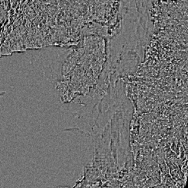
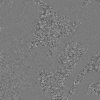
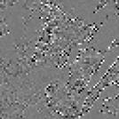
16 LL 1st to 567 3rd 4th 3 component JAXA/METI
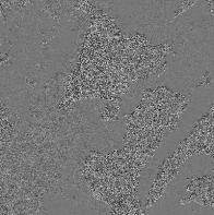
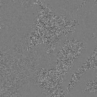
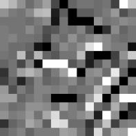
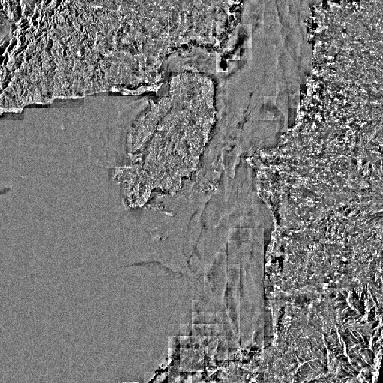
17 The Result imagery of the Wavelet analysis of ALOS/PALSAR Point Point Point Point Point Point Observed on Aug.25, 06 JAXA/METI
18 The Profile of Wavelet Spectrum between the spilled oil area and the normal sea surface. Oil spilled sea surface area Point 1 Point The normal sea surface area 1 Point Point Point Point Point 6
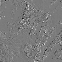
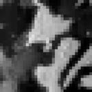
19 Mapping of the Oil-Spilled Area detected by Wavelet Analysis Point Point Point Point Point Point Estimated Oil Spilled Area Estimated normal Sea Surface Area


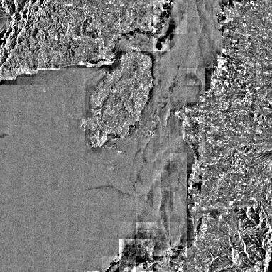
20 JAXA/METI Observed on Aug.27, 06 JAXA/METI
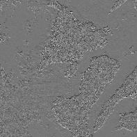
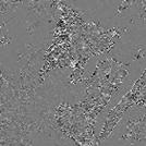
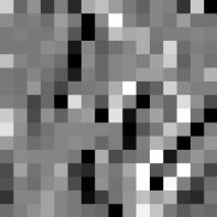
21 The Result Imagery of the Wavelet analysis of ALOS/PALSAR Point 5 Point 3 Point 4 Point 1 Point 6 Point 2 The sampling points are selected in the area detected as an spilled led area Point 131 The sampling points are selected in the normal sea surface area Point 46


22 The Comparison of Wavelet spectrum profile between the spilled oil area and the normal sea surface. Oil spilled sea surface area Point 1 Point 4 Point 2 Point 5 Point 3 Point 6
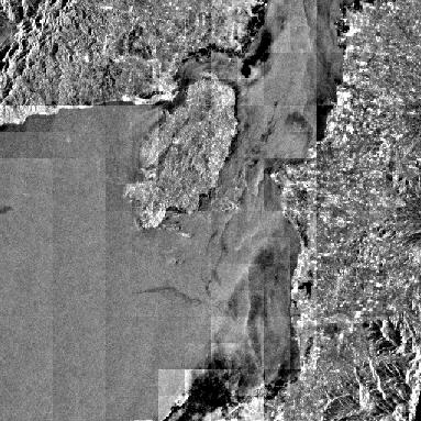
23 Mapping of the Oil Spilled Area detected by Wavelet Analysis Point 5 Point 3 Point 4 Point 1 Point 6 Point 2 Estimated Oil Spilled Area Estimated normal Sea Surface Area
24 The Comparison with Map Products of UNOSAT Aug. 27, 06UNOSAT ENVISAT/ASAR ( Aug. 24, 2006) RADARSAT ( Aug. 27, 2006)

 ALOS/PALSAR")
25 The Comparison with Map Products of UNOSAT JAXA/METI ENVISAT/ASAR ( Aug. 24, 2006) ALOS/PALSAR (Aug. 25, 2006)

26 The Comparison with Map Products of UNOSAT Aug.24, 2006ENVISAT Aug. 25, 2006PALSAR
 Aug. 27, 06UNOSAT RADARSAT ( Aug.")
27 The Comparison with Map Products of UNOSAT JAXA/METI ALOS/PALSAR ( Aug. 27, 2006) Aug. 27, 06UNOSAT RADARSAT ( Aug. 27, 2006)

28 The Comparison with Map Products of UNOSAT The coverage of ALOS/PALSAR Fine mode Aug.27, 2006RADARSAT Aug. 27, 2006PALSAR

29 The Comparison with Map Products of UNOSAT ENVISAT Aug.24,2006 PALSAR Aug.27,2006 PALSAR Aug.25,2006 RADARSAT Aug.27,2006 Aug.27, 2006RADARSAT Aug. 27, 2006PALSAR

30 The Detected Oil-Spilled area from the satellite observation data

31 5-2. The oil Tanker Prestige (Spain), Nov. 13, 2002 The Prestige carrying more than 67,000 tons of oil encountered ered a violent storm at about 150miles off from Spain's Atlantic coast. The leak of spilled oil was at least 6,700 tons sunk early in the day of 19 November Photos (copyright AP)

, Nov.")


32 5-2. The oil Tanker Prestige (Spain), Nov. 13, 2002 Disaster source Occurrence date: Nov. 13, 02 C ESA Mapping The result imagery of Wavelet Analysis

33 PAJ Oil Spill Symposium 2008 Tokyo 13.0W 12.0W 11.0W VisionTech Inc. 10.0W 9.0W 8.0W 7.0W 6.0W 45.0N 44.0N 2002/11/18 18:28 RADARSAT 43.0N 2002/11/25 07:05 RADARSAT 2002/11/17 10:4442.0N ENVISAT 41.0N

34 11/18/2002 RADARSAT 11/25 RADARSAT 11/17/2002 ENVISAT (copyright AP)
35 5-3. An Unknown Oil-spill, (Sweden), May 09, 2005 A 97-kilometer oil slick was discovered off Sweden's South-Eastern coast in the Baltic Sea during a routine flight of Swedish Coast Guard. About 25tons of oil were located between the islands of Gotland and Oland,, however it was not known where the oil came from.


36 5-3. An Unknown Oil-spill, (Sweden), May 09, 2005 Disaster source Occurrence date: May 09, 05 C ESA Wavelet Analysis Mapping The result imagery of Wavelet Analysis ENVISAT //


37 The Result Imagery of the Wavelet analysis ( Color Composite Imagery)


38 Mapping Image Photo: Swedish Coast Guard
39 5-4. Oil-fuel storage tanks of Power plant, (Lebanon), July 13,15, 2005 The oil-fuelled power plant of Jieh located on the coastline about 30 km south of Beirut was hit by bombs on July 13 and 15, 2006 in the course of the conflict of the Middle East. An estimated 30,000 tons of heavy fuel oil leaked into the Mediterranean sea.

, July")


40 5-4. Oil-fuel storage tanks of Power plant, (Lebanon), July 13,15, 2005 Disaster source C METI/JAXA C ESA C ESA Aug.06, :15 ERS-2/AMI Mapping The result imagery of Wavelet Analysis
 Observation date and")

41 The Detected Oil Spilled Area (Color Composite Imagery) Observation date and time ENVISAT/ASAR Aug. 03, :40 ERS-2/AMI Aug. 06, :15 ALOS/PALSAR Aug :10


42 The Detected Oil-Spilled area from the satellite observation data
43 Wind Speed m/s Time & Date Time & Date May 10 May 9 May 10 May 8 May 9 May 7 May 8 May 6 May 7 May 6 Observation data Moving Average
44 gt πu 2 1/3 5 [ { ( ) } ] 10 + gf /3/ / = U
45
46
47 7. Conclusion By applying Wavelet analysis to a synthetic aperture radar imagery, it was shown that the possibility of the detection of the oil slicks could be performed in high probability. It is possible for automatic recognition of the oil slicks without human interpretation if this technique is established. And it can use as one of the method of the screening. Furthermore, using the SAR data under the conditions from which the weather and the sea surface differ, Oil Slick has been recognized by this method. It shows a possibility that it could use day and night under all-weather condition. The verification of the recognition probability by the difference such as the thinness (thickness) of oil and the wave height of the sea surface, will be also done as the next phase.
48 M. Hara, VisionTech Inc.
KEY WORDS: Oil spill modeling, Envisat ASAR, M/T Solar 1, Guimaras, Philippines.
 HYDRODYNAMIC AND TRAJECTORY MODELING OF THE AUGUST 11, 2006 M/T SOLAR 1 OIL SPILL IN GUIMARAS, CENTRAL PHILIPPINES WITH VALIDATION USING ENVISAT ASAR DATA Jojene R. Santillan and Enrico C. Paringit Research
Introduction of PALSAR and PALSAR Data Application Plan
 Introduction of PALSAR and PALSAR Data Application Plan September 19 th, 2006 Tomonori Deguchi deguchi@ersdac.or.jp Earth Remote Sensing Data Analysis Center (ERSDAC) http://www.ersdac.or.jp Contents 1.
OCEAN SURFACE DRIFT BY WAVELET TRACKING USING ERS-2 AND ENVISAT SAR IMAGES
 OCEAN SURFACE DRIFT BY WAVELET TRACKING USING ERS-2 AND ENVISAT SAR IMAGES Antony K. Liu, Yunhe Zhao Ocean Sciences Branch, NASA Goddard Space Flight Center, Greenbelt, Maryland, USA Ming-Kuang Hsu Northern
Monitoring Sea Ice with Space-borne Synthetic Aperture Radar
 Monitoring Sea Ice with Space-borne Synthetic Aperture Radar Torbjørn Eltoft UiT- the Arctic University of Norway CIRFA A Centre for Research-based Innovation cirfa.uit.no Sea ice & climate Some basic
Remote Sensing I: Basics
 Remote Sensing I: Basics Kelly M. Brunt Earth System Science Interdisciplinary Center, University of Maryland Cryospheric Science Laboratory, Goddard Space Flight Center kelly.m.brunt@nasa.gov (Based on
RADAR Remote Sensing Application Examples
 RADAR Remote Sensing Application Examples! All-weather capability: Microwave penetrates clouds! Construction of short-interval time series through cloud cover - crop-growth cycle! Roughness - Land cover,
Multisensor monitoring of Peter the Great Bay
 Multisensor monitoring of Peter the Great Bay Leonid Mitnik, Vyacheslav Dubina, Oleg Konstantinov and Vitaly Fischenko V.I. Il'ichev Pacific Oceanological Institute FEB RAS 43 Baltiyskaya St. 690041 Vladivostok,
New Era of Global Monitoring by ALOS-2: Advanced Land Observing Satellite-2 DAICHI-2 Yuko Suzuki
 New Era of Global Monitoring by ALOS-2: Advanced Land Observing Satellite-2 DAICHI-2 Yuko Suzuki International Relations and Research Department Japan Aerospace Exploration Agency (JAXA) 1 Dawning Era
Indonesian seas Numerical Assessment of the Coastal Environment (IndoNACE) Executive Summary
 Executive Summary") Indonesian seas Numerical Assessment of the Coastal Environment (IndoNACE) Executive Summary Study team members: Dr. Martin Gade, PD Dr. Thomas Pohlmann, Dr. Mutiara Putri Research Centres: Universität
Indonesian seas Numerical Assessment of the Coastal Environment (IndoNACE) Executive Summary Study team members: Dr. Martin Gade, PD Dr. Thomas Pohlmann, Dr. Mutiara Putri Research Centres: Universität
VIDEO/LASER HELICOPTER SENSOR TO COLLECT PACK ICE PROPERTIES FOR VALIDATION OF RADARSAT SAR BACKSCATTER VALUES
 VIDEO/LASER HELICOPTER SENSOR TO COLLECT PACK ICE PROPERTIES FOR VALIDATION OF RADARSAT SAR BACKSCATTER VALUES S.J. Prinsenberg 1, I.K. Peterson 1 and L. Lalumiere 2 1 Bedford Institute of Oceanography,
GEOSC/METEO 597K Kevin Bowley Kaitlin Walsh
 GEOSC/METEO 597K Kevin Bowley Kaitlin Walsh Timeline of Satellites ERS-1 (1991-2000) NSCAT (1996) Envisat (2002) RADARSAT (2007) Seasat (1978) TOPEX/Poseidon (1992-2005) QuikSCAT (1999) Jason-2 (2008)
4. Verification and evaluation (monitoring) 4.1 Verification using visual information
 4.1 Verification using visual information") 4. Verification and evaluation (monitoring) 4.1 Verification using visual information Information on sightings of debris reported by ships is available on the web site of the Japanese government (http://www.kantei.go.jp/jp/singi/kaiyou/hyouryuu/senpaku.html).
4. Verification and evaluation (monitoring) 4.1 Verification using visual information Information on sightings of debris reported by ships is available on the web site of the Japanese government (http://www.kantei.go.jp/jp/singi/kaiyou/hyouryuu/senpaku.html).
Improved sea-ice monitoring for the Baltic Sea Project summary
 Improved sea-ice monitoring for the Baltic Sea Project summary Leif E.B. Eriksson (1), Karin Borenäs (2), Wolfgang Dierking (3), Anders Berg (1) and Per Pemberton (2) (1) Chalmers University of Technology,
OPERATIONAL SATELLITE MONITORING OF OIL SPILL POLLUTION IN THE SOUTHEASTERN BALTIC SEA: 1.5 YEARS EXPERIENCE
 US/EU-Baltic International Symposium May 23-25, 2006 Klaipeda, Lithuania OPERATIONAL SATELLITE MONITORING OF OIL SPILL POLLUTION IN THE SOUTHEASTERN BALTIC SEA: 1.5 YEARS EXPERIENCE 2006, Andrey G. Kostianoy
MESOSCALE VARIABILITIES IN SEA SURFACE CURRENT FIELDS DERIVED THROUGH MULTI-SENSOR TRACKING OF SEA SURFACE FILMS
 MESOSCALE VARIABILITIES IN SEA SURFACE CURRENT FIELDS DERIVED THROUGH MULTI-SENSOR TRACKING OF SEA SURFACE FILMS Benjamin Seppke (1), Martin Gade (2), Leonie Dreschler-Fischer (2) (1) University of Hamburg,
The Importance of Microwave Remote Sensing for Operational Sea Ice Services And Challenges
 The Importance of Microwave Remote Sensing for Operational Sea Ice Services And Challenges Wolfgang Dierking January 2015 (1) Why is microwave remote sensing important (=useful) for sea ice mapping? Problems
Satellite Remote Sensing for Ocean
 Satellite Remote Sensing for Ocean August 17, 2017 Masatoshi Kamei RESTEC All rights reserved RESTEC 2015 Contents 1. About RESTEC and Remote Sensing 2. Example of Remote Sensing Technology 3. Remote Sensing
Ice Observations on the Churchill River using Satellite Imagery
 CGU HS Committee on River Ice Processes and the Environment 15 th Workshop on River Ice St. John s, Newfoundland and Labrador, June 15-17, 2009 Ice Observations on the Churchill River using Satellite Imagery
Remote Sensing for Sea Surface Monitoring. Cristina Bentz PETROBRAS R&D Center Environment Assessment and Monitoring
 Remote Sensing for Sea Surface Monitoring Cristina Bentz PETROBRAS R&D Center Environment Assessment and Monitoring cris@petrobras.com.br Overview Introduction Orbital sea surface monitoring: Scope and
Amina Rangoonwala and Elijah Ramsey III Wetland and Aquatic Research Center. U.S. Geological Survey. Lafayette, LA
 First I will show examples of radar mapping of hurricane surge extent and duration and optical mapping of the resultant marsh dieback along the Louisiana coast Next we extend these works to hurricane Sandy
DEMOSS. Title: Development of Marine Oil Spills/slicks Satellite monitoring System elements for the Black Sea, Caspian Sea and /Kara/Barents Seas
 DEMOSS Title: Development of Marine Oil Spills/slicks Satellite monitoring System elements for the Black Sea, Caspian Sea and /Kara/Barents Seas INTAS Thematic Call on Earth Sciences and Environment in
A MODEL FOR RISES AND DOWNS OF THE GREATEST LAKE ON EARTH
 A MODEL FOR RISES AND DOWNS OF THE GREATEST LAKE ON EARTH Parviz Tarikhi Iranian Remote Sensing Center, Iran May 2005 1 Figure 1: West of Novshahr in the Iranian coast of Caspian; the dam constructed to
EONav Satellite data in support of maritime route optimization
 EONav Satellite data in support of maritime route optimization Leif Eriksson Department of Space, Earth and Environment Chalmers University of Technology Outline Why is maritime navigation support needed?
Currents and Objects
 SAR Marine Applications Currents and Objects Martin Gade Uni Hamburg, Institut für Meereskunde martin.gade@uni-hamburg.de SAR Maritime Applications Friday, 9 Sep, Morning: 1 - History & Basics Introduction
J2.6 SONAR MEASUREMENTS IN THE GULF STREAM FRONT ON THE SOUTHEAST FLORIDA SHELF COORDINATED WITH TERRASAR-X SATELLITE OVERPASSES
 J2.6 SONAR MEASUREMENTS IN THE GULF STREAM FRONT ON THE SOUTHEAST FLORIDA SHELF COORDINATED WITH TERRASAR-X SATELLITE OVERPASSES Chris Maingot 1, Alexander Soloviev 1, Silvia Matt 1, Mikhail Gilman 1,
Developing integrated remote sensing and GIS procedures for oil spill monitoring on the Libyan coast
 Coastal Processes III 125 Developing integrated remote sensing and GIS procedures for oil spill monitoring on the Libyan coast A. Eljabri & C. Gallagher Department of Civil Engineering and Built Environment,
EXPLOITING SUNGLINT SIGNATURES FROM MERIS AND MODIS IMAGERY IN COMBINATION TO SAR DATA TO DETECT OIL SLICKS
 EXPLOITING SUNGLINT SIGNATURES FROM MERIS AND MODIS IMAGERY IN COMBINATION TO SAR DATA TO DETECT OIL SLICKS M. Adamo 1, G. De Carolis 2, V. De Pasquale 2, and G. Pasquariello 2 1 Dept. of Physics, University
TOSCA RESULTS OVERVIEW
 TOSCA RESULTS OVERVIEW Almost 3 years after the project started, TOSCA has proved capable of improving oil spill tracking systems. TOSCA has brought updated knowledge on surface currents and noticeable
Operational ice charting in mid-latitudes using Near-Real-Time SAR imagery
 Operational ice charting in mid-latitudes using Near-Real-Time SAR imagery Sergey Vernyayev Ice Engineer ICEMAN.KZ Carles Debart Project Manager Energy, Environment and Security Yevgeniy Kadranov Ice charting
PREDICTION AND MONITORING OF OCEANIC DISASTERS USING MICROWAVE REMOTE SENSING TECHNIQUES
 PREDICTION AND MONITORING OF OCEANIC DISASTERS USING MICROWAVE REMOTE SENSING TECHNIQUES O P N Calla International Centre for Radio Science, OM NIWAS A-23, Shastri Nagar, Jodhpur-342 003 Abstract The disasters
New NASA Ocean Observations and Coastal Applications
 New NASA Ocean Observations and Coastal Applications Duane Armstrong Chief, Applied Science & Technology Project Office August 20, 2014 1 Outline NASA s new Earth Science Ocean Science Missions for 2014
A Wavelet Technique to Extract the Backscatter Signatures from SAR Images of the Sea
 266 PIERS Proceedings, Moscow, Russia, August 18 21, 2009 A Wavelet Technique to Extract the Backscatter Signatures from SAR Images of the Sea S. Zecchetto 1, F. De Biasio 1, and P. Trivero 2 1 Istituto
EXTRACTION OF FLOODED AREAS DUE THE 2015 KANTO-TOHOKU HEAVY RAINFALL IN JAPAN USING PALSAR-2 IMAGES
 EXTRACTION OF FLOODED AREAS DUE THE 2015 KANTO-TOHOKU HEAVY RAINFALL IN JAPAN USING PALSAR-2 IMAGES F. Yamazaki a, *, W. Liu a a Chiba University, Graduate School of Engineering, Chiba 263-8522, Japan
Coastal Ocean Applications Demonstrations of ALOS PALSAR Imagery for NOAA CoastWatch
 Coastal Ocean Applications Demonstrations of ALOS PALSAR Imagery for NOAA CoastWatch William Pichel Center for Satellite Applications and Research Frank Monaldo The Johns Hopkins University Applied Physics
PREDICTION OF OIL SPILL TRAJECTORY WITH THE MMD-JMA OIL SPILL MODEL
 PREDICTION OF OIL SPILL TRAJECTORY WITH THE MMD-JMA OIL SPILL MODEL Project Background Information MUHAMMAD HELMI ABDULLAH MALAYSIAN METEOROLOGICAL DEPARTMENT(MMD) MINISTRY OF SCIENCE, TECHNOLOGY AND INNOVATION
oil spill statistics data integration for marine pollution
 oil spill statistics Joint Research Centre, GAUSS, Kongsberg Satellite Services, Norwegian Computing Centre, German Federal Institute of Hydrology, Bolding & Burchard Hydrodynamics, QinetiQ, HELCOM, German
Remote sensing of sea ice
 Remote sensing of sea ice Ice concentration/extent Age/type Drift Melting Thickness Christian Haas Remote Sensing Methods Passive: senses shortwave (visible), thermal (infrared) or microwave radiation
DAMAGE DETECTION OF THE 2008 SICHUAN, CHINA EARTHQUAKE FROM ALOS OPTICAL IMAGES
 DAMAGE DETECTION OF THE 2008 SICHUAN, CHINA EARTHQUAKE FROM ALOS OPTICAL IMAGES Wen Liu, Fumio Yamazaki Department of Urban Environment Systems, Graduate School of Engineering, Chiba University, 1-33,
Annex VI-1. Draft National Report on Ocean Remote Sensing in China. (Reviewed by the Second Meeting of NOWPAP WG4)
") UNEP/NOWPAP/CEARAC/WG4 2/9 Page1 Draft National Report on Ocean Remote Sensing in China (Reviewed by the Second Meeting of NOWPAP WG4) UNEP/NOWPAP/CEARAC/WG4 2/9 Page1 1. Status of RS utilization in marine
UNEP/NOWPAP/CEARAC/WG4 2/9 Page1 Draft National Report on Ocean Remote Sensing in China (Reviewed by the Second Meeting of NOWPAP WG4) UNEP/NOWPAP/CEARAC/WG4 2/9 Page1 1. Status of RS utilization in marine
Instituto de Ingeniería, UNAM, México SPILL-SATCON, Satellite Constellation Mission Idea to Detect Oil Spills in Oceans
 SPILL-SATCON, Satellite Constellation Mission Idea to Detect Oil Spills in Oceans Dr. Esaú Vicente Vivas, Instituto de Ingeniería (II), UNAM, evv@unam.mx, C.Dr. Adán Espinoza Millán, Moscow State University,
1 Introduction. 2 Wind dependent boundary conditions for oil slick detection. 2.1 Some theoretical aspects
 On C-Band SAR Based Oil Slick Detection in the Baltic Sea Markku Similä, István Heiler, Juha Karvonen, and Kimmo Kahma Finnish Institute of Marine Research (FIMR), PB 2, FIN-00561, Helsinki, Finland Email
SAR Data Help Improving the Monitoring of Intertidal Flats on the German North Sea Coast
 SAR Data Help Improving the Monitoring of Intertidal Flats on the German North Sea Coast Martin Gade (1), Kerstin Stelzer (2), and Jörn Kohlus (3) (1) Institut für Meereskunde, Universität Hamburg, Hamburg,
Training Course on Radar & Optical RS, IES, Cēsis, Latvia, 5-9 September SAR Marine Applications. Wind and Waves
 SAR Marine Applications Wind and Waves Martin Gade Uni Hamburg, Institut für Meereskunde martin.gade@uni-hamburg.de SAR Marine Applications Friday, 9 Sep, Morning: 1 - History & Basics Introduction Radar/SAR
OIL SPILL DETECTION USING RADAR
 D. Badea, P. Dumitru, O. Bădescu, D. Vasilca Oil spill detection using Radar OIL SPILL DETECTION USING RADAR dr. ing. Dragos Badea, s.l. Faculty of Geodesy Bucharest, badea_dragos@yahoo.com dr. ing. Paul
Validation of sea ice concentration in the myocean Arctic Monitoring and Forecasting Centre 1
 Note No. 12/2010 oceanography, remote sensing Oslo, August 9, 2010 Validation of sea ice concentration in the myocean Arctic Monitoring and Forecasting Centre 1 Arne Melsom 1 This document contains hyperlinks
Hurricane Season 2010 & NOAA s Deepwater Response
 Hurricane Season 2010 & NOAA s Deepwater Response What s Happened? What Will 2010 Bring? Possible Shoreline Effects Darin Figurskey Meteorologist-in-Charge NOAA s NWS Raleigh, NC NOAA s National Weather
Earth Observation in coastal zone MetOcean design criteria
 ESA Oil & Gas Workshop 2010 Earth Observation in coastal zone MetOcean design criteria Cees de Valk BMT ARGOSS Wind, wave and current design criteria geophysical process uncertainty modelling assumptions
Automated Damage Assessment for Event Response from Overhead Imagery. Shari Matzner Jerry Tagestad Sadie Montgomery Andre Coleman Tom Warfel
 Automated Damage Assessment for Event Response from Overhead Imagery Shari Matzner Jerry Tagestad Sadie Montgomery Andre Coleman Tom Warfel The power is out Extreme weather events are the primary cause
Distribution and Thickness of Different Sea Ice Types and Extreme Ice Features in the Beaufort Sea: 2012 Field Report
 Distribution and Thickness of Different Sea Ice Types and Extreme Ice Features in the Beaufort Sea: 2012 Field Report July 2012 NCR#5859681 - v1 DISTRIBUTION AND THICKNESS OF DIFFERENT SEA ICE TYPES AND
Satellite Meteorology. Protecting Life and Property Around the World
 Satellite Meteorology Protecting Life and Property Around the World The Value of Forecasting Severe Weather Flooding events across Europe in August 2002 cost in the region of 20 billion; 20,000 people
Wave processes in Arctic Seas, observed from TerraSAR-X
 DISTRIBUTION STATEMENT A. Approved for public release; distribution is unlimited. Wave processes in Arctic Seas, observed from TerraSAR-X Susanne Lehner DLR German Air and Space Research Center Earth Observation
Use of Satellite Earth Observations, in situ data and numerical model capabilities for oil spill contingency. Page 1
 Use of Satellite Earth Observations, in situ data and numerical model capabilities for oil spill contingency Page 1 Oil spill service Page 2 Interest of Earth-Observation (EO) data for oil and gas companies
Davida Streett NOAA/NESDIS. NESDIS Satellite Analysis Branch Hazard Mitigation Programs
 ESA 2010 Oil Davida Streett NOAA/NESDIS NESDIS Satellite Analysis Branch Hazard Mitigation Programs Operational 24 x 7 x 365 Fire and Smoke Precipitation Tropical Storms/Hurricanes Oil/Marine Pollution
THIN ICE AREA EXTRACTION IN THE SEASONAL SEA ICE ZONES OF THE NORTHERN HEMISPHERE USING MODIS DATA
 THIN ICE AREA EXTRACTION IN THE SEASONAL SEA ICE ZONES OF THE NORTHERN HEMISPHERE USING MODIS DATA K. Hayashi 1, K. Naoki 1, K. Cho 1 *, 1 Tokai University, 2-28-4, Tomigaya, Shibuya-ku, Tokyo, Japan,
Sentinel Asia System Operation for Disaster Management in Sri Lanka Major General L.B.R. Mark (Retd) Director General Disaster Management Centre
 Director General Disaster Management Centre") Sentinel Asia System Operation for Disaster Management in Sri Lanka Major General L.B.R. Mark (Retd) Director General Disaster Management Centre Government of Sri Lanka OUTLINE Background Disasters in
Sentinel Asia System Operation for Disaster Management in Sri Lanka Major General L.B.R. Mark (Retd) Director General Disaster Management Centre Government of Sri Lanka OUTLINE Background Disasters in
DLR s TerraSAR-X contributes to international fleet of radar satellites to map the Arctic and Antarctica
 DLR s TerraSAR-X contributes to international fleet of radar satellites to map the Arctic and Antarctica The polar regions play an important role in the Earth system. The snow and ice covered ocean and
JAXA s Contributions to the Climate Change Monitoring
 0 JAXA s Contributions to the Climate Change Monitoring June 7, 2011 Takao Akutsu Planning Manager Japan Aerospace Exploration Agency (JAXA) Japanese Main Activities of Earth Observation 1 GEOSS 10 years
EVALUATION OF CLASSIFICATION METHODS WITH POLARIMETRIC ALOS/PALSAR DATA
 EVALUATION OF CLASSIFICATION METHODS WITH POLARIMETRIC ALOS/PALSAR DATA Anne LÖNNQVIST a, Yrjö RAUSTE a, Heikki AHOLA a, Matthieu MOLINIER a, and Tuomas HÄME a a VTT Technical Research Centre of Finland,
Contents Preface xiil Chapter 1 Introduction to Remote Sensing
 Preface xii Chapter 1 Introduction to Remote Sensing 1 1.1 Order of Battle 2 1.1.1 Air order of battle 3 1.1.2 Electronic order of battle 3 1.1.3 Space order of battle 7 1.1.4 Naval order of battle 8 1.2
INDIVIDUAL WAVE HEIGHT FROM SAR
 INDIVIDUAL WAVE HEIGHT FROM SAR W. Rosenthal (1), S.Lehner (2) (1), GKSS, D 2102 Geesthacht, Email:Wolfgang.Rosenthal@gkss.de (2), DLR, D82234 Wessling,, Email:Susanne.Lehner@dlr.de ABSTRACT Safety of
DUAL-POLARIZED COSMO SKYMED SAR DATA TO OBSERVE METALLIC TARGETS AT SEA
 DUAL-POLARIZED COSMO SKYMED SAR DATA TO OBSERVE METALLIC TARGETS AT SEA F. Nunziata, M. Montuori and M. Migliaccio Università degli Studi di Napoli Parthenope Dipartimento per le Tecnologie Centro Direzionale,
Current Status of the ALOS-2 Operation and PALSAR-2 Calibration Activities
 Current Status of the ALOS-2 Operation and PALSAR-2 Calibration Activities Takeshi Motohka, Ryo Natsuaki, Yukihiro Kankaku, Shinichi Suzuki, Masanobu Shimada (JAXA) Osamu Isoguchi (RESTEC) CEOS SAR CALVAL
Government of Sultanate of Oman Public Authority of Civil Aviation Directorate General of Meteorology. National Report To
 Government of Sultanate of Oman Public Authority of Civil Aviation Directorate General of Meteorology National Report To Panel on Tropical Cyclones in the Bay of Bengal And Arabian Sea 43rd Session, India
!"#$%&' #(!()* +,-'.,$ &%!/(%)!'%
* +,-'.,$ &%!/(%)!'%") !"#$%&' #(!()* +,-'.,$ &%!/(%)!'% /01234 5013673 Iranian Remote Sensing Center (IRSC) No. 22, 14 th Street, Saadat-Abad Tehran 19979, Iran Tel: +98 21 2063207 Fax: +98 21 2064474 E-mail: irsc@www.dci.co.ir
!"#$%&' #(!()* +,-'.,$ &%!/(%)!'% /01234 5013673 Iranian Remote Sensing Center (IRSC) No. 22, 14 th Street, Saadat-Abad Tehran 19979, Iran Tel: +98 21 2063207 Fax: +98 21 2064474 E-mail: irsc@www.dci.co.ir
Application Status and Prospect of Microwave Remote Sensing
 2017 International Conference on Computing, Communications and Automation(I3CA 2017) Application Status and Prospect of Microwave Remote Sensing Cheng Lele, Yan Xinsui, Zhou Mengqiu, Zhou Yongqin, Wang
Sharafat GADIMOVA Azerbaijan National Aerospace Agency (ANASA), Azerbaijan
, Azerbaijan") TOWARDS THE DEVELOPMENT OF AN OPERATIONAL STRATEGY FOR OIL SPILL DETECTION AND MONITORING IN THE CASPIAN SEA BASED UPON A TECHNICAL EVALUATION OF SATELLITE SAR OBSERVATIONS IN SOUTHEAST ASIA Sharafat GADIMOVA
TOWARDS THE DEVELOPMENT OF AN OPERATIONAL STRATEGY FOR OIL SPILL DETECTION AND MONITORING IN THE CASPIAN SEA BASED UPON A TECHNICAL EVALUATION OF SATELLITE SAR OBSERVATIONS IN SOUTHEAST ASIA Sharafat GADIMOVA
THE DEVELOPMENT OF THE METHOD FOR UPDATING LAND SURFACE DATA BY USING MULTI-TEMPORALLY ARCHIVED SATELLITE IMAGES
 THE DEVELOPMENT OF THE METHOD FOR UPDATING LAND SURFACE DATA BY USING MULTI-TEMPORALLY ARCHIVED SATELLITE IMAGES Y. Usuda a, N. Watanabe b, H. Fukui a a Graduate School of Media and Governance, Keio Univ.,
Monthly Volcanic Activity Report (February, 2011)
") Monthly Volcanic Activity Report (February, 2011) Japan Meteorological Agency Izu-Oshima[ Alert Level : 1] Earthquakes at the western offshore areas of Izu-Oshima increased on 9 th temporarily in this
Monthly Volcanic Activity Report (February, 2011) Japan Meteorological Agency Izu-Oshima[ Alert Level : 1] Earthquakes at the western offshore areas of Izu-Oshima increased on 9 th temporarily in this
Mersea Oil Spill Drift Forecast Demonstrations in TOP2
 Mersea Oil Spill Drift Forecast Demonstrations in TOP2 Bruce Hackett (met.no), George Zodiatis (UCY), Pierre Daniel (MeteoFrance), Francois Parthiot (Cedre) Presented at 3rd Mersea Plenary Meeting, CNR,
Infrastructure monitoring using SAR interferometry
 Infrastructure monitoring using SAR interferometry Hossein Nahavandchi Roghayeh Shamshiri Norwegian University of Science and Technology (NTNU), Department of Civil and Environmental Engineering Geodesy
Utilization of SAR and optical images/data for monitoring of the coastal environment
 Utilization of SAR and optical images/data for monitoring of the coastal environment What is an oil spill? Various petroleum products and their derivatives (petrol, kerosene, gasoline, diesel fuel, fuel,
UrtheCast s High Resolution Imagery, HD Video and Synthetic Aperture Radar from Space for Smart Earth Observations Dr. Rao S.
 UrtheCast s High Resolution Imagery, HD Video and Synthetic Aperture Radar from Space for Smart Earth Observations Dr. Rao S. Ramayanam Vice President Middle East, Africa and South Asia Geo Smart Asia
ANALYSIS OF ASAR POLARISATION SIGNATURES FROM URBAN AREAS (AO-434)
") ANALYSIS OF ASAR POLARISATION SIGNATURES FROM URBAN AREAS (AO-434) Dan Johan Weydahl and Richard Olsen Norwegian Defence Research Establishment (FFI), P.O. Box 25, NO-2027 Kjeller, NORWAY, Email: dan-johan.weydahl@ffi.no
ANALYSIS OF ASAR POLARISATION SIGNATURES FROM URBAN AREAS (AO-434) Dan Johan Weydahl and Richard Olsen Norwegian Defence Research Establishment (FFI), P.O. Box 25, NO-2027 Kjeller, NORWAY, Email: dan-johan.weydahl@ffi.no
The impact of the assimilation of altimeters and ASAR L2 wave data in the wave model MFWAM
 The impact of the assimilation of altimeters and ASAR L2 wave data in the wave model MFWAM Lotfi Aouf 1, Jean-Michel Lefèvre 1 1) Météo-France, Toulouse 12 th Wave Hindcasting and Forecasting, Big Island
Fjernmåling og modellering av oljesøl - på åpen sjø og i is
 Fjernmåling og modellering av oljesøl - på åpen sjø og i is Associate Professor, Camilla Brekke CIRFA (SFI) WP3 leader - Oil Spill Remote Sensing cirfa.uit.no What we are aiming for Detection & characterization
SAR Training Course, MCST, Kalkara, Malta, November SAR Maritime Applications. Wind and Waves
 SAR Maritime Applications Wind and Waves Martin Gade Uni Hamburg, Institut für Meereskunde SAR Maritime Applications Thursday, 13 Nov.: 1 - History & Basics Introduction Radar/SAR History Basics Scatterometer
CNES R&D and available software for Space Images based risk and disaster management
 CNES R&D and available software for Space Images based risk and disaster management 1/21 Contributors: CNES (Centre National d Etudes Spatiales), Toulouse, France Hélène Vadon Jordi Inglada 2/21 Content
Japanese Programs on Space and Water Applications
 Japanese Programs on Space and Water Applications Tamotsu IGARASHI Remote Sensing Technology Center of Japan June 2006 COPUOS 2006 Vienna International Centre Water-related hazards/disasters may occur
EO-Based Ice and Iceberg Monitoring in Support of Offshore Engineering Design and Tactical Operations
 EO-Based Ice and Iceberg Monitoring in Support of Offshore Engineering Design and Tactical Operations Desmond Power, C-CORE ESA Industry Workshop on Satellite EO for the Oil and Gas Sector Overview Operations
PAJ Oil Spill Simulation Model for the Sea of Okhotsk
 PAJ Oil Spill Simulation Model for the Sea of Okhotsk 1. Introduction Fuji Research Institute Corporation Takashi Fujii In order to assist in remedial activities in the event of a major oil spill The Petroleum
The Potential of High Resolution Satellite Interferometry for Monitoring Enhanced Oil Recovery
 The Potential of High Resolution Satellite Interferometry for Monitoring Enhanced Oil Recovery Urs Wegmüller a Lutz Petrat b Karsten Zimmermann c Issa al Quseimi d 1 Introduction Over the last years land
REGIONAL MARINE POLLUTION EMERGENCY RESPONSE CENTRE FOR THE MEDITERRANEAN SEA (REMPEC) MEDITERRANEAN ACTION PLAN
 MEDITERRANEAN ACTION PLAN") REGIONAL MARINE POLLUTION EMERGENCY RESPONSE CENTRE FOR THE MEDITERRANEAN SEA (REMPEC) MEDITERRANEAN ACTION PLAN AERIAL AND SATELLITE SURVEILLANCE OF OPERATIONAL POLLUTION WITHIN THE ADRIATIC SEA: A COMPARATIVE
REGIONAL MARINE POLLUTION EMERGENCY RESPONSE CENTRE FOR THE MEDITERRANEAN SEA (REMPEC) MEDITERRANEAN ACTION PLAN AERIAL AND SATELLITE SURVEILLANCE OF OPERATIONAL POLLUTION WITHIN THE ADRIATIC SEA: A COMPARATIVE
PETROLEUM HAZARDS MANAGEMENT BY GEOMATIC SYSTEMS
 PETROLEUM HAZARDS MANAGEMENT BY GEOMATIC SYSTEMS H. ASSILZADEH Spatial Information Technology & Engineering (SITE) Research Center Faculty of Engineering, Universiti Putra Malaysia, 43400 UPM, Serdang
Description of the case study
 Description of the case study During the night and early morning of the 14 th of July 011 the significant cloud layer expanding in the West of the country and slowly moving East produced precipitation
Application of Satellite SAR images to Sea and Wind Monitoring in Coastal Seas
 Application of Satellite SAR images to Sea and Wind Monitoring in Coastal Seas E. Pugliese Carratelli & F. Dentale University of Salerno, Department of Civil Engineering, Via Ponte Don Melillo 88, Fisciano,
Correlating Radioactive Material to Sea Surface Temperature off the Coast of Japan: The Fukushima Daiichi Nuclear Disaster. Maya R.
 Correlating Radioactive Material to Sea Surface Temperature off the Coast of Japan: The Fukushima Daiichi Nuclear Disaster Maya R. Pincus Department of Geology, University of Puerto Rico-Mayagüez e-mail:
HOMOGENEOUS VALIDATION SCHEME OF THE OSI SAF SEA SURFACE TEMPERATURE PRODUCTS
 HOMOGENEOUS VALIDATION SCHEME OF THE OSI SAF SEA SURFACE TEMPERATURE PRODUCTS Pierre Le Borgne, Gérard Legendre, Anne Marsouin, Sonia Péré Météo-France/DP/Centre de Météorologie Spatiale BP 50747, 22307
Erich Gundlach, Ph.D.
 Oil Shoreline Interactions: Deepwater Horizon SETAC Boston, November 2011 Erich Gundlach, Ph.D. E-Tech International Inc. New York, USA ErichEti@ cs.com www.oil-spill-info.com What s Going On Shorelines
Convective downbursts are known to produce potentially hazardous weather
 Investigation of Convective Downburst Hazards to Marine Transportation Mason, Derek Thomas Jefferson High School for Science and Technology Alexandria, VA Abstract Convective downbursts are known to produce
«Data management and visualization issues of the Copernicus satellite data»
 «Data management and visualization issues of the Copernicus satellite data» Dr. Panos Lolonis Member of the Scientific Council NATIONAL CADASTRE AND MAPPING AGENCY S.A. 288 Mesogion Ave 155 62 Holaros
SAWS: Met-Ocean Data & Infrastructure in Support of Industry, Research & Public Good. South Africa-Norway Science Week, 2016
 SAWS: Met-Ocean Data & Infrastructure in Support of Industry, Research & Public Good South Africa-Norway Science Week, 2016 Marc de Vos, November 2016 South Africa: Context http://learn.mindset.co.za/sites/default/files/resourcelib/e
Sentinel-1 Long Duration Mutual Interference
 MPC-S1 Sentinel-1 Long Duration Mutual Interference Reference: Nomenclature: MPC-0432 DI-MPC-ARC Issue: 1. 0 Date: 2018,Dec.04 MPC-0432 DI-MPC-ARC V1.0 2018,Dec.04 i.1 Chronology Issues: Issue: Date: Reason
Overview of the Tropical Cyclone Guidance Project
 Overview of the Tropical Cyclone Guidance Project Dr. Jonathan L. Vigh With thanks to Mahsa Mirzargar (Univ. of Miami) Shanghai Typhoon Institute 09 July 2018 NCAR is sponsored by the National Science
Phases of Disaster Response. John Yeaw, Gavin Vanstone, Haochen Wu, Jordan Tyler
 Phases of Disaster Response John Yeaw, Gavin Vanstone, Haochen Wu, Jordan Tyler BP Oil Spill One of the worst man made disasters in human history The BP oil spill occurred in April of 2010 when the Deepwater
USE OF INTERFEROMETRIC SATELLITE SAR FOR EARTHQUAKE DAMAGE DETECTION ABSTRACT
 USE OF INTERFEROMETRIC SATELLITE SAR FOR EARTHQUAKE DAMAGE DETECTION Masashi Matsuoka 1 and Fumio Yamazaki 2 ABSTRACT Synthetic Aperture Radar (SAR) is one of the most promising remote sensing technologies
Detection, tracking and study of polar lows from satellites Leonid P. Bobylev
 Detection, tracking and study of polar lows from satellites Leonid P. Bobylev Nansen Centre, St. Petersburg, Russia Nansen Centre, Bergen, Norway Polar lows and their general characteristics International
ASSESSMENT AND RESTORATION OF COASTAL ECOSYSTEMS USING REMOTE SENSING AND VISUALIZATION TOOLS FOR THE GULF OF MEXICO AND BEYOND
 ASSESSMENT AND RESTORATION OF COASTAL ECOSYSTEMS USING REMOTE SENSING AND VISUALIZATION TOOLS FOR THE GULF OF MEXICO AND BEYOND Remote Sensing as a Tool for Ecosystem Restoration George Graettinger Office
CONTRAILS FROM (A)ATSR(2) DATA
ATSR(2) DATA") CONTRAILS FROM (A)ATSR(2) DATA Hermann Mannstein and Rüdiger Büll Deutsches Zentrum für Luft- und Raumfahrt, Oberpfaffenhofen, 82230 Wessling, Germany ABSTRACT/RESUME The DLR contrail detection algorithm
CONTRAILS FROM (A)ATSR(2) DATA Hermann Mannstein and Rüdiger Büll Deutsches Zentrum für Luft- und Raumfahrt, Oberpfaffenhofen, 82230 Wessling, Germany ABSTRACT/RESUME The DLR contrail detection algorithm
Mapping Coastal Change Using LiDAR and Multispectral Imagery
 Mapping Coastal Change Using LiDAR and Multispectral Imagery Contributor: Patrick Collins, Technical Solutions Engineer Presented by TABLE OF CONTENTS Introduction... 1 Coastal Change... 1 Mapping Coastal
EO4SEE - THE PATHFINDER OF OPERATIONAL SATELLITE MONITORING FOR THE REGION OF THE BLACK SEA AND CENTRAL EUROPE
 EO4SEE: Pathfinder assessment for regional high volume data access, processing and information service delivery platforms - South East Region EO4SEE - THE PATHFINDER OF OPERATIONAL SATELLITE MONITORING