ASSESSMENT AND RESTORATION OF COASTAL ECOSYSTEMS USING REMOTE SENSING AND VISUALIZATION TOOLS FOR THE GULF OF MEXICO AND BEYOND
|
|
|
- Cory Hunt
- 5 years ago
- Views:
Transcription


1 ASSESSMENT AND RESTORATION OF COASTAL ECOSYSTEMS USING REMOTE SENSING AND VISUALIZATION TOOLS FOR THE GULF OF MEXICO AND BEYOND Remote Sensing as a Tool for Ecosystem Restoration George Graettinger Office of Response & Restoration RAE October 23, 2012 Tampa, FL

")
 Response")
2 CONTINUUM OF RESPONSE FRAMEWORK FOR THE OFFICE OF RESPONSE & RESTORATION Response (24 hours) Recovery or Restoration (Years/Decades) Response Assessment Restoration
3 REMOTE SENSING UTILIZATION IN OR&R Response and remediation serves as primary restoration Damage Assessment and Restoration projects for OR&R case work Oyster, Fish, Bird, Shoreline and SAV DWH NRDA Shoreline assessment, characterization, remediation, and restoration Restoration project assessment, shoreline position and vulnerabilities for sea-level rise
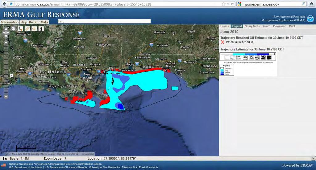
4 OR&R VISUALIZATION TOOLS Environmental Response Management Application (ERMA ) gomex.erma.noaa.gov Desktop/Online PhotoLogger Paired desktop and online geo-tagged photo management DIVER Explorer Query Tool Chemistry, Tissue, Effects database

5 WHAT IS ERMA? ERMA is an online mapping tool for visualizing environmental information relevant to oil spills, natural disasters, and the release of hazardous materials

6 Web-based mapping tool WHAT IS ERMA? Provides centralized access to information Increases communication, coordination, and efficiency Prepare for, respond to, assess impacts from hazardous incidents or conditions Analyze and visualize environmental information relevant to all hazards
7 HOW ERMA CAN HELP YOU? Data Collection, Visualization, and Sharing Cross Jurisdictional boundaries (Multi Agency, Multi State) Natural Resource Information Sensitive habitats Species distribution and life history Threatened & Endangered Species identification Resource at Risk reporting Restoration planning Critical Infrastructure Railroad Lines Water intake locations Critical facilities and hazards information Aid in the development of Response Plans Environmental Sensitivity Index (ESI) maps Area Contingency Planning (ACP) Geographic Response Plans (GRP)

8 WHERE IS ERMA?
9 Base Mapping STANDARD ERMA DATA SETS Google aerial, terrain, roads Nautical charts Incident Information Trajectories Real time resource tracking Shoreline oiling Sampling data Weather & Sensors Hurricane/Storms Remote-sensing imagery Local habitat and species Infrastructure Roads/railroads Critical facilities Resources at Risk NOAA ESI data layers Federal & local critical resources and habitats Seafood safety Documents & Photo Links ESI and GRP.pdfs Attached to layers Field photos
10 REMOTE SENSING DATA FOR RESPONSE Multi-Agency Airborne Platform NASA AVIRIS Hyperspectral Ocean Imaging MSS/Thermal Canadian/Icelandic Coast Guard SLAR Coastal Shoreline Aerial Photography RGB, NIR Ad-hoc Geo-tagged Photography Satellite Platform GOES MODIS/MERIS SAR LANDSAT SPOT

11 GOES IMAGERY APRIL 21 ST, 2010

12 MODIS GULFWIDE MONITORING

13 REMOTE SENSING DATA: MODIS/MERIS Advantages Daily coverage Freely distributed Visible, middle IR, thermal IR data Precedent for use in oil detection Drawbacks Clouds, sun glint, and wind limitations Coarse resolution
14 NASA AVIRIS AVIRIS Hyperspectral 220+ band data 3m 20m data resolution Collected in NASA ER-2 and NOAA King Air USGS published method for surface oil thickness and volume estimates

15 REMOTE SENSING DATA: AVIRIS Advantages Hyperspectral (collects 228 different wavelengths) Fine resolution Peer-reviewed method for estimating oil extent, thickness Drawbacks Highly susceptible to environmental conditions Lack of Gulf-wide coverage Massive data storage requirements
16 NOAA NESDIS SAR data application Used as default oil footprint for operations and observational data capture Marine Pollution Surveillance Report Moved from Experimental to Operational during Deepwater Horizon oil spill Provides near-real time support for response operations Daily composite products
17 REMOTE SENSING DATA: SAR (RADAR) Advantages Daily coverage on multiple satellites Penetrates through clouds Precedent for use detecting oil on water Drawbacks Hard to differentiate sheen from thick oil
18 SAR data used RADARSAT 1 & 2 ENVISAT SPOT LANDSAT NOAA NESDIS MODIS/MERIS (occasional use) Other sensors Multiple sensors used to create daily composite footprints

19 NESDIS POLLUTION REPORT (SPOT 5)
20 NESDIS POLLUTION REPORT (RADARSAT-1)
")
21 NESDIS POLLUTION REPORT (ENVISAT)

22 POTENTIAL OILING SAR DATA

23 POTENTIAL OILING FOOTPRINT
24 NOAA NESDIS SAR data production enhancements Texture Classifying Neural Network Analysis (TCNNA) Move from manual digitized areas to supervised classification Standard, repeatable process Eliminate variability Automate development

25 COMPOSITE SAR INDEX


26 CANADIAN/ICELANDIC COAST GUARD SLAR SLAR data collected from Canadian and Icelandic DASH 8 Similar in coverage and content to SAR Limited coverage relative to SAR products Used by Operations to target Actionable oil

27 OCEAN IMAGING MSS 4 BAND Ocean Imaging Deepwater Coverage 2 Flights/day MC252 Source Shoreline


28 OCEAN IMAGING MSS 4 BAND Ocean Imaging Deepwater Products MC252 source imaging Multiple thickness categories

29 OCEAN IMAGING MSS 4 BAND Ocean Imaging Deepwater Products Quick turn around < 45 minutes post wheels down Identify high risk, high priority targets Thick, actionable oil

30 REMOTE SENSING DATA: OCEAN IMAGING DATA Advantages Visible plus thermal data Data processed daily for source and limited for shoreline Used in multiple spill response efforts Disadvantages Limited spatial and temporal coverage Proprietary application and methods
 439 medium format airborne mapping system")

31 NOAA NGS NOAA Image Collection King Air Twin Otter Equipment Applanix Digital Sensor System (DSS) 439 medium format airborne mapping system 4-band ortho-imager (RGB & NIR sensors) Resolution 0.35m resolution RGB/NIR ortho-photography High impact area shoreline coverage Shoreline and source missions
32 NOAA NGS & BP IMAGERY Shoreline collections for Pre-impact NOAA NGS May/June 2010 Multi season post-impact NOAA NGS October 2010 Combined RGB/NIR data - total of 13,439 photos Combined RGB/NIR data - total of 5,032 mosaic tiles BP/Trustee Collections (Aerometric) April 2011, 2012 October 2010, 2011, 2012


33 NOAA NGS & BP SHORELINE COVERAGE

34 NGS IMAGERY FOR DWH


35 NGS IMAGERY CRITICAL RESPONSE USE Marsh/Wetland vegetation monitoring Boom placement and displacement SAV monitoring, assessment, restoration Displaced boom SAV emergency restoration Prop scaring
36 IMAGERY FOR NRDA CASE SUPPORT
37 IMAGERY FOR NRDA CASE SUPPORT
38 IMAGERY FOR NRDA CASE SUPPORT


39 IMAGERY FOR NRDA CASE SUPPORT
40 DWH AERIAL OBSERVATIONAL OVERFLIGHTS NOAA King Air and Twin Otter USCG Fixed wing and Helicopter platforms NOAA Trained observers Consistent oiling observation reporting GPS and Geo-tagged photography

41 OVERFLIGHT OBSERVATIONS AND PHOTOS
42 OVERFLIGHT OBSERVATIONS AND PHOTOS

43 OVERFLIGHT OBSERVATIONS AND PHOTOS
44 NOAA TRAJECTORY FORECAST MODEL OR&R generates oil forecasts 24, 48, 72 hour Trajectories NESDIS SAR Potential Oiling Footprints Oiling overflight observation reports and geotagged photos Environmental conditions (Wind, currents, wave height) Other environmental observation data

45 NOAA TRAJECTORY FORECAST MODEL OR&R Trajectories 3 forecasts created twice daily Characterize open water oiling condition Predict shoreline oiling Identified uncertainty Model oil coverage and age
46 TRAJECTORIES AND ERMA
47 FIELD PERSONNEL TRACKING

48 REMOTELY OPERATED VEHICLES Sub-surface observations & monitoring Well head, blow-out preventer and riser pipe monitoring Sub-surface dispersant application

49 DATA STORAGE AND ACCESS USGS EROS Data Center HDDS Public Government Commercial data for disaster response Multiple platform data
50 NRDA TECHNICAL WORK GROUP SUPPORT Shoreline TWG Shoreline Exposure Modeling Coastal Wetland Vegetation Habitat Classification, Mudflat, Land/Water interface SAV TWG Shoreline Imagery Collection Detailed collection criteria for SAV identification (Water clarity, sun angle/glint) Emergency restoration of SAV response injury Supervised Classification of SAV Fish TWG Oysters health and production monitoring Sargassum communities identification and quantification Nearshore sediments and water sampling Telemetry TWG Tagged species tracking

51 SAV EMERGENCY RESTORATION Prop scars and blow-out Identification Monitoring Restoration

52 MARINE MAMMAL SIGHTINGS

53 MARSH VEGETATION MONITORING

54 DISASTER RESPONSE DATA INTEGRATION

55 RESOURCES AT RISK
56 REMOTE SENSING & THE OR&R MISSION Support the inventory of resources Response prioritization based on potential risk from oiling or chemical release Damage assessment from initial insult and injuries from response activities Evaluation of restoration potential
57 ERMA TOOLS & REMOTE SENSING DATA Lessons learned from Deepwater Horizon expanding how OR&R utilizes remote sensing data Satellite and airborne remote sensing offering additional service for identifying and monitoring impacted resources Web-based mapping tools and visualization increase the access and usability of remote sensing data to traditional case work Remote sensing data provides excellent tools for effective assessment and improved success in restoration

58 Thank-you! Please visit our Public ERMA Gulf Response site. gomex.erma.noaa.gov/erma.html
Environmental Response Management Application
 Environmental Response Management Application Coastal Response Research Center Nancy Kinner, Michele Jacobi, Rob Braswell, Kurt Schwehr & Amy Merten RRT III May 14, 2008 1 Talk Outline Overview of Center
Coastal Response Research Center. Nancy Kinner University of New Hampshire (UNH) Michele Jacobi NOAA ORR. September 27, 2007
 Michele Jacobi NOAA ORR. September 27, 2007") Coastal Response Research Center Nancy Kinner University of New Hampshire (UNH) Michele Jacobi NOAA ORR September 27, 2007 1 Coastal Response Research Center (CRRC) CRRC is partnership between NOAA s Office
Coastal Response Research Center Nancy Kinner University of New Hampshire (UNH) Michele Jacobi NOAA ORR September 27, 2007 1 Coastal Response Research Center (CRRC) CRRC is partnership between NOAA s Office
New NASA Ocean Observations and Coastal Applications
 New NASA Ocean Observations and Coastal Applications Duane Armstrong Chief, Applied Science & Technology Project Office August 20, 2014 1 Outline NASA s new Earth Science Ocean Science Missions for 2014
GIS in Response to Oil Spills and other Deleterious Materials
 GIS in Response to Oil Spills and other Deleterious Materials Judd Muskat California Department of Fish and Wildlife Office of Spill Prevention and Response What I Will Cover Office of Spill Prevention
Hurricane Season 2010 & NOAA s Deepwater Response
 Hurricane Season 2010 & NOAA s Deepwater Response What s Happened? What Will 2010 Bring? Possible Shoreline Effects Darin Figurskey Meteorologist-in-Charge NOAA s NWS Raleigh, NC NOAA s National Weather
Extent and Degree of Shoreline Oiling: Deepwater Horizon (DWH) Oil Spill, Scott Zengel Research Planning, Inc. Tallahassee, Florida
 Oil Spill, Scott Zengel Research Planning, Inc. Tallahassee, Florida") Extent and Degree of Shoreline Oiling: Deepwater Horizon (DWH) Oil Spill, 2010 2013 Scott Zengel Research Planning, Inc. Tallahassee, Florida Background & Definitions SCAT survey data presented here SCAT
Extent and Degree of Shoreline Oiling: Deepwater Horizon (DWH) Oil Spill, 2010 2013 Scott Zengel Research Planning, Inc. Tallahassee, Florida Background & Definitions SCAT survey data presented here SCAT
State-of-the-Art GIS as an Integrating Technology
 Paper # 104: GIS for Oil Spill Prevention & Response Devon Humphrey Instructor, National Spill Control School Texas A&M University at Corpus Christi, TX Introduction and History The National Spill Control
Environmental Sensitivity to Oil Spills in Gulf Shores, AL
 1 Environmental Sensitivity to Oil Spills in Gulf Shores, AL Prepared by: Matthew Dobbertien 2 December 2011 CE 394K: GIS in Water Resources Dr. David Maidment University of Texas at Austin 1 2 Content
Hurricane Katrina and Oil Spills: Impact on Coastal and Ocean Environments
 Archived version from NCDOCKS Institutional Repository http://libres.uncg.edu/ir/asu/ Pine, J. C. (June 2006). Hurricane Katrina and oil spills: Impact on coastal and ocean environments. Oceanography,
PETROLEUM HAZARDS MANAGEMENT BY GEOMATIC SYSTEMS
 PETROLEUM HAZARDS MANAGEMENT BY GEOMATIC SYSTEMS H. ASSILZADEH Spatial Information Technology & Engineering (SITE) Research Center Faculty of Engineering, Universiti Putra Malaysia, 43400 UPM, Serdang
University of New Hampshire Scholars' Repository
 University of New Hampshire University of New Hampshire Scholars' Repository Center for Coastal and Ocean Mapping Center for Coastal and Ocean Mapping 3-2009 Environmental Response Management Application
Geographic Response Plan Mapping and Digital Area Contingency Plan
 Geographic Response Plan Mapping and Digital Area Contingency Plan Ryan Druyor Digital ACP Coordinator Florida Fish and Wildlife Conservation Commission Fish and Wildlife Research Institute Background
Davida Streett NOAA/NESDIS. NESDIS Satellite Analysis Branch Hazard Mitigation Programs
 ESA 2010 Oil Davida Streett NOAA/NESDIS NESDIS Satellite Analysis Branch Hazard Mitigation Programs Operational 24 x 7 x 365 Fire and Smoke Precipitation Tropical Storms/Hurricanes Oil/Marine Pollution
European Space Agency
 Guidelines - Guidelines how/when to interact during the WebEx session: - Due to the number of attendees, please keep always your webcam and microphone switched-off - You can use anytime the chat to all
Coastal Ocean Applications Demonstrations of ALOS PALSAR Imagery for NOAA CoastWatch
 Coastal Ocean Applications Demonstrations of ALOS PALSAR Imagery for NOAA CoastWatch William Pichel Center for Satellite Applications and Research Frank Monaldo The Johns Hopkins University Applied Physics
UAS Applications Tim McCarthy, NUI Maynooth INFOMAR 9 th Oct
 UAS Applications Tim McCarthy, NUI Maynooth INFOMAR 9 th Oct 2013 1 About Us National Centre for Geocomputation (NCG) Established in 2004 with an SFI PI Grant 4 X PIs coordinate various research projects
Sources of Imagery and GIS Data Layers (Last updated October 2005)
") Sources of Imagery and GIS Data Layers (Last updated October 2005) The question of where to find data is one often asked by beginners in precision agriculture and other geospatial projects. The following
Sources of Imagery and GIS Data Layers (Last updated October 2005) The question of where to find data is one often asked by beginners in precision agriculture and other geospatial projects. The following
Using Remote Sensing Technologies to Improve Resilience
 4 Using Remote Sensing Technologies to Improve Resilience Ronald T. Eguchi CEO, ImageCat, Inc. 6 years ago The world had just survived the Y2K bug with no major incidents Nations around the world commit
Remote Sensing and Incident Support. Department of Homeland Security February 22, 2013
 Remote Sensing and Incident Support Department of Homeland Security February 22, 2013 Introductions and Goals Today s Webcast will be Presented by: Chris Barnard DHS Remote Sensing Advisor Chris Vaughan
Add NOAA nowcoast Layers to Maps
 WebEOC Maps Add-on Quick Reference Guide Add NOAA nowcoast Layers to Maps Overview With Maps Add-on, you can configure an unlimited number of map layers. These layers allow you to control the data you
Mapping Coastal Change Using LiDAR and Multispectral Imagery
 Mapping Coastal Change Using LiDAR and Multispectral Imagery Contributor: Patrick Collins, Technical Solutions Engineer Presented by TABLE OF CONTENTS Introduction... 1 Coastal Change... 1 Mapping Coastal
JALBTCX AND THE USACE NATIONAL COASTAL MAPPING PROGRAM
 JALBTCX AND THE USACE NATIONAL COASTAL MAPPING PROGRAM 237 237 237 217 217 217 200 200 200 80 119 27 252 174.59 1 255 255 255 0 0 0 163 163 163 131 132 122 239 65 53 110 135 120 112 92 56 62 102 130 102
Earth Observation for Emergency Response and the International Charter on Space and Major Disasters.
 Earth Observation for Emergency Response and the International Charter on Space and Major Disasters. Case studies of the 2016 Alberta wildfires and 2017 Québec flooding Simon Tolszczuk-Leclerc 1, Brad
PAJ Oil Spill Simulation Model for the Sea of Okhotsk
 PAJ Oil Spill Simulation Model for the Sea of Okhotsk 1. Introduction Fuji Research Institute Corporation Takashi Fujii In order to assist in remedial activities in the event of a major oil spill The Petroleum
Developing integrated remote sensing and GIS procedures for oil spill monitoring on the Libyan coast
 Coastal Processes III 125 Developing integrated remote sensing and GIS procedures for oil spill monitoring on the Libyan coast A. Eljabri & C. Gallagher Department of Civil Engineering and Built Environment,
Introduction: The Gulf of Mexico Alliance. The Gulf GAME project MERMAid and PHINS Results & Conclusions What s next? Examples
 AAG Las Vegas March 25, 2009 Introduction: Ocean governance and Ecosystem-Based Management The Gulf of Mexico Alliance Habitat Identification and Characterization The Gulf GAME project MERMAid and PHINS
3 SHORELINE CLASSIFICATION METHODOLOGY
 3 SHORELINE CLASSIFICATION METHODOLOGY Introduction The ESI scale, as described in Section 2, categorizes coastal habitats in terms of their susceptibility to spilled oil, taking into consideration a number
Background Field program information Examples of measurements Wind validation for synthetic modeling effort
 Background Field program information Examples of measurements Wind validation for synthetic modeling effort How do complex fine-scale structure and processes in coastal waters dominated by pulsed-river
Climate Risk Visualization for Adaptation Planning and Emergency Response
 Climate Risk Visualization for Adaptation Planning and Emergency Response NCR Flood Fact Finding Workshop Ricardo Saavedra ricardo@vizonomy.com Social Media, Mobile, and Big Data St. Peter s Basilica,
Operational ice charting in mid-latitudes using Near-Real-Time SAR imagery
 Operational ice charting in mid-latitudes using Near-Real-Time SAR imagery Sergey Vernyayev Ice Engineer ICEMAN.KZ Carles Debart Project Manager Energy, Environment and Security Yevgeniy Kadranov Ice charting
Use of in-situ and remote sensors, sampling, and systems for assessing extent, fate, impact, and mitigation of oil and dispersants
 Use of in-situ and remote sensors, sampling, and systems for assessing extent, fate, impact, and mitigation of oil and dispersants Gustavo Jorge Goni (NOAA/AOML, Miami, FL) Gustavo.Goni@noaa.gov and the
Impact & Recovery of Wetland Plant Communities after the Gulf Oil Spill in 2010 and Hurricane Isaac in 2012
 Impact & Recovery of Wetland Plant Communities after the Gulf Oil Spill in 2010 and Hurricane Isaac in 2012 Introduction: The coastal wetlands, estuaries and lagoon systems of the Gulf Coast are a hotspot
Introducing the. a partnership of
 Introducing the a partnership of Background Need for online atlas identified by managers and researchers to make coastal data available Shoreline data Ocean and coastal resources Sea-level rise potential
Effective Utilization of Synthetic Aperture Radar (SAR) Imagery in Rapid Damage Assessment
 Imagery in Rapid Damage Assessment") Effective Utilization of Synthetic Aperture Radar (SAR) Imagery in Rapid Damage Assessment Case Study Pakistan Floods SUPARCO M. Maisam Raza, Ahmad H. Rabbani SEQUENCE Flood Monitoring using Satellite
Effective Utilization of Synthetic Aperture Radar (SAR) Imagery in Rapid Damage Assessment Case Study Pakistan Floods SUPARCO M. Maisam Raza, Ahmad H. Rabbani SEQUENCE Flood Monitoring using Satellite
Quick Response Report #126 Hurricane Floyd Flood Mapping Integrating Landsat 7 TM Satellite Imagery and DEM Data
 Quick Response Report #126 Hurricane Floyd Flood Mapping Integrating Landsat 7 TM Satellite Imagery and DEM Data Jeffrey D. Colby Yong Wang Karen Mulcahy Department of Geography East Carolina University
Amina Rangoonwala and Elijah Ramsey III Wetland and Aquatic Research Center. U.S. Geological Survey. Lafayette, LA
 First I will show examples of radar mapping of hurricane surge extent and duration and optical mapping of the resultant marsh dieback along the Louisiana coast Next we extend these works to hurricane Sandy
Ice Observations on the Churchill River using Satellite Imagery
 CGU HS Committee on River Ice Processes and the Environment 15 th Workshop on River Ice St. John s, Newfoundland and Labrador, June 15-17, 2009 Ice Observations on the Churchill River using Satellite Imagery
Application of Wavelet Spectrum Analysis to Oil Spill Detection by Using Satellite Observation Data
 PAJ Oil Spill Symposium 2008 Application of Wavelet Spectrum Analysis to Oil Spill Detection by Using Satellite Observation Data February 21, 2008 Tokyo, Japan Masanao Hara Dr., VisionTech Inc. 1. Background
GIS: a common operational picture for public safety and emergency management
 Safety and Security Engineering IV 455 GIS: a common operational picture for public safety and emergency management J. Perdikaris School of Engineering, University of Guelph, Canada Abstract Not so long
A MODEL FOR RISES AND DOWNS OF THE GREATEST LAKE ON EARTH
 A MODEL FOR RISES AND DOWNS OF THE GREATEST LAKE ON EARTH Parviz Tarikhi Iranian Remote Sensing Center, Iran May 2005 1 Figure 1: West of Novshahr in the Iranian coast of Caspian; the dam constructed to
Towards eenvironment Prague, March GMES Space Component. Josef Aschbacher Head, ESA GMES Space Office
 Towards eenvironment Prague, 25-27 March 2009 GMES Space Component Josef Aschbacher Head, ESA GMES Space Office Prague from Space Segment 2 05 Nov 2003 CNES 2003 GISAT 2007 ESA GSELAND GMES is an EU led
Capturing a Holistic Understanding of a Large Marine Ecosystem The NOAA Gulf of Mexico Data Atlas
 Capturing a Holistic Understanding of a Large Marine Ecosystem The NOAA Gulf of Mexico Data Atlas NODC / National Coastal Data Development Center gulfalas.noaa.gov Need: data that contribute to long-term
GIS and Remote Sensing
 Spring School Land use and the vulnerability of socio-ecosystems to climate change: remote sensing and modelling techniques GIS and Remote Sensing Katerina Tzavella Project Researcher PhD candidate Technology
July 5-6, 2010 Mytilene, Greece
 Web GIS platform for forest fire management Prof. Kostas Kalabokidis Principal Investigator Univ. of the Aegean, Dept. of Geography, Greece Prof. George Kallos Univ. of Athens, Dept. of Physics, Greece
Monitoring Sea Ice with Space-borne Synthetic Aperture Radar
 Monitoring Sea Ice with Space-borne Synthetic Aperture Radar Torbjørn Eltoft UiT- the Arctic University of Norway CIRFA A Centre for Research-based Innovation cirfa.uit.no Sea ice & climate Some basic
NOAA S Arctic Program in 2017
 NOAA S Arctic Program in 2017 NOAA s Arctic Mission To determine how the Arctic system is changing on time scales of weeks to decades, particularly with respect to the consequences that the loss of sea
Assessing fate and transport issues of the DWH oil spill using simulations and merged datasets
 Assessing fate and transport issues of the DWH oil spill using simulations and merged datasets Pat Fitzpatrick Geosystems Research Institute Mississippi State University The influence of cyclones on the
Science & Monitoring to Assess the Success of Restoration Projects related to the DWH Oil Spill & Natural Resource Damage Assessment and Restoration
 Science & Monitoring to Assess the Success of Restoration Projects related to the DWH Oil Spill & Natural Resource Damage Assessment and Restoration Alyssa Dausman & Jo Ellen Hinck U.S. Geological Survey
Use of Satellite Earth Observations, in situ data and numerical model capabilities for oil spill contingency. Page 1
 Use of Satellite Earth Observations, in situ data and numerical model capabilities for oil spill contingency Page 1 Oil spill service Page 2 Interest of Earth-Observation (EO) data for oil and gas companies
Use of Elevation Data in NOAA Coastal Mapping Shoreline Products. Coastal GeoTools April 1, 2015
 Use of Elevation Data in NOAA Coastal Mapping Shoreline Products Coastal GeoTools April 1, 2015 - NOAA s Coastal Mapping Program & CUSP - Shoreline Uses, Delineation Issues, Definitions - Current Extraction
Mapping Water Resources and Reservoirs for Climate Resilience in Zambezi River Basin
 Mapping Water Resources and Reservoirs for Climate Resilience in Zambezi River Basin Corné van der Sande, NEO BV Senior Advisor Earth Observation Services for Monitoring Drought and Water Resources in
Unmanned Aircraft Systems (UAS) Activities in Earth Sciences
 Activities in Earth Sciences") Unmanned Aircraft Systems (UAS) Activities in Earth Sciences Bruce K. Quirk quirk@usgs.gov Department of the Interior U.S. Geological Survey June 22, 2015 Department of the Interior Bureau of Land Management
Unmanned Aircraft Systems (UAS) Activities in Earth Sciences Bruce K. Quirk quirk@usgs.gov Department of the Interior U.S. Geological Survey June 22, 2015 Department of the Interior Bureau of Land Management
Arctic Risk Map. Communicating Region s Complex Risk Picture. Øivin Aarnes Esri Petroleum GIS Conference. London, Nov. 6th DNV GL OIL & GAS
 DNV GL OIL & GAS Arctic Risk Map Communicating Region s Complex Risk Picture Øivin Aarnes Esri Petroleum GIS Conference. London, Nov. 6th. 2015 1 2015 9 November 2015 SAFER, SMARTER, GREENER DNV GL Global
Role of GIS in Tracking and Controlling Spread of Disease
 Role of GIS in Tracking and Controlling Spread of Disease For Dr. Baqer Al-Ramadan By Syed Imran Quadri CRP 514: Introduction to GIS Introduction Problem Statement Objectives Methodology of Study Literature
Remote Sensing Techniques for Renewable Energy Projects. Dr Stuart Clough APEM Ltd
 Remote Sensing Techniques for Renewable Energy Projects Dr Stuart Clough APEM Ltd What is Remote Sensing? The use of aerial sensors to detect and classify objects on Earth Remote sensing for ecological
NATURAL FORCE THREATS, MONITORING AND RESEARCH NEEDS
 NATURAL FORCE THREATS, MONITORING AND RESEARCH NEEDS 1 Southern California Thomas Fire and Montecito Debris Flows 2 Timeline/Description of Conditions Between December 4, 2017 and January 12, 2018, over
GIS-Based Sediment Quality Database for the St. Louis River Area of Concern (AOC): Overview Presentations and Demonstration
: Overview Presentations and Demonstration") GIS-Based Sediment Quality Database for the St. Louis River Area of Concern (AOC): Overview Presentations and Demonstration Judy L. Crane 1 and Dawn E. Smorong 2 1 Minnesota Pollution Control Agency, St.
GIS-Based Sediment Quality Database for the St. Louis River Area of Concern (AOC): Overview Presentations and Demonstration Judy L. Crane 1 and Dawn E. Smorong 2 1 Minnesota Pollution Control Agency, St.
Remote Sensing I: Basics
 Remote Sensing I: Basics Kelly M. Brunt Earth System Science Interdisciplinary Center, University of Maryland Cryospheric Science Laboratory, Goddard Space Flight Center kelly.m.brunt@nasa.gov (Based on
The Use of Geographic Information Systems to Assess Change in Salt Marsh Ecosystems Under Rising Sea Level Scenarios.
 The Use of Geographic Information Systems to Assess Change in Salt Marsh Ecosystems Under Rising Sea Level Scenarios Robert Hancock The ecological challenges presented by global climate change are vast,
Lesson 4b Remote Sensing and geospatial analysis to integrate observations over larger scales
 Lesson 4b Remote Sensing and geospatial analysis to integrate observations over larger scales We have discussed static sensors, human-based (participatory) sensing, and mobile sensing Remote sensing: Satellite
Remote detection of giant reed invasions in riparian habitats: challenges and opportunities for management planning
 Remote detection of giant reed invasions in riparian habitats: challenges and opportunities for management planning Maria do Rosário Pereira Fernandes Forest Research Centre, University of Lisbon Number
Alaska Ocean Observing System 101 Anchorage, Alaska
 Alaska Ocean Observing System 101 Anchorage, Alaska Molly McCammon, Director Alaska Ocean Observing System (AOOS) A Regional Observing System within the Integrated Ocean Observing System www.aoos.org IOOS
Positioning the Pacific: NOAA s Geospatial Activities. Juliana Blackwell, Director NOAA s National Geodetic Survey March 6, 2012
 Positioning the Pacific: NOAA s Geospatial Activities Juliana Blackwell, Director NOAA s National Geodetic Survey March 6, 2012 A Common Problem of the Early 19 th Century 1807 President Thomas Jefferson
GEOSC/METEO 597K Kevin Bowley Kaitlin Walsh
 GEOSC/METEO 597K Kevin Bowley Kaitlin Walsh Timeline of Satellites ERS-1 (1991-2000) NSCAT (1996) Envisat (2002) RADARSAT (2007) Seasat (1978) TOPEX/Poseidon (1992-2005) QuikSCAT (1999) Jason-2 (2008)
King Fahd University Of Petroleum and Minerals
 King Fahd University Of Petroleum and Minerals Construction Engineering & Management Department Construction Project Management CRP (514) Term (102) Term Paper Report Supervised by: Prof. Baqer M. Al-Ramadan
Development of an International Arctic Observations Assessment Framework
 Development of an International Arctic Observations Assessment Framework Dr. Steven Lev, Dr. Jason Gallo Briefing for the Sustaining Arctic Observing Networks (SAON) April 7, 2017 International Partners
Geo-information and Disaster Risk Reduction in the Hindu Kush-Himalayan region
 Geo-information and Disaster Risk Reduction in the Hindu Kush-Himalayan region Basanta Shrestha, Division Head MENRIS, International Centre for Integrated Mountain Development Kathmandu, Nepal The International
ESP Process Flow. 2/27/2012 Environmental Studies Program 1
 ESP Process Flow 2/27/2012 Environmental Studies Program 1 Studies Management Process Timeline Oct Nov Dec Jan Feb Mar Apr May Jun Jul Aug SDP Guidance Stakeholder Input Due SDP Preparation Draft SDPs
NOAA s OCM: Services, tools and collaboration opportunities & Puerto Rico s NE Marine Corridor as a case study
 NOAA s OCM: Services, tools and collaboration opportunities & Puerto Rico s NE Marine Corridor as a case study Dr. Antares Ramos Álvarez NOAA s Office of Coastal Management September 15 th, 2016 Conservation
CLIMATE CHANGE ADAPTATION BY MEANS OF PUBLIC PRIVATE PARTNERSHIP TO ESTABLISH EARLY WARNING SYSTEM
 CLIMATE CHANGE ADAPTATION BY MEANS OF PUBLIC PRIVATE PARTNERSHIP TO ESTABLISH EARLY WARNING SYSTEM By: Dr Mamadou Lamine BAH, National Director Direction Nationale de la Meteorologie (DNM), Guinea President,
Phases of Disaster Response. John Yeaw, Gavin Vanstone, Haochen Wu, Jordan Tyler
 Phases of Disaster Response John Yeaw, Gavin Vanstone, Haochen Wu, Jordan Tyler BP Oil Spill One of the worst man made disasters in human history The BP oil spill occurred in April of 2010 when the Deepwater
Environmental Risk from Ship traffic along the Norwegian Coast Odd Willy Brude, Det Norske Veritas, Veritasveien 1, 1322 Høvik, Norway
 Environmental Risk from Ship traffic along the Norwegian Coast 15.02.2012 Odd Willy Brude, Det Norske Veritas, Veritasveien 1, 1322 Høvik, Norway Marte Braathen, Det Norske Veritas, Veritasveien 1, 1322
Marine Debris in the Gulf of Mexico
 Marine Debris in the Gulf of Mexico Peter Murphy NOAA Marine Debris Program / Genwest Biloxi, Mississippi October 25, 2009 Outline 1. Project Background 2. Process 3. 2006-2007 Alabama, Mississippi 4.
THE USE OF GEOMATICS IN CULTURAL HERITAGE AND ARCHAEOLOGY FOR VARIOUS PURPOSES
 THE USE OF GEOMATICS IN CULTURAL HERITAGE AND ARCHAEOLOGY FOR VARIOUS PURPOSES FEBRUARY 2013 AL BEIDA GEOPLAN CONTENT Company Profile Concept Objectives and Strategies Data Production Methods Data Samples
Harmful Algal Bloom Detectives in the Gulf of Mexico Satellites, Gliders and Buoys, Oh My!
 Harmful Algal Bloom Detectives in the Gulf of Mexico Satellites, Gliders and Buoys, Oh My! By Chris Simoniello and Ruth Mullins* With information from: *The Gulf of Mexico Coastal Ocean Observing System
Environmental Data In Support of Search & Rescue Operations in the Central Mediterranean Sea
 Environmental Data In Support of Search & Rescue Operations in the Central Mediterranean Sea Dr. Eric Comerma (RPS ASA) eric.comerma@rpsgroup.com Cathleen Turner (RPS ASA) Prof. Aldo Drago (Univ. of Malta)
3Chapter Three: Rescue and Response
 17 16 Report Science Title and the Storms: the USGS Response to the Hurricanes of 2005 3Chapter Three: Rescue and Response This chapter documents the U.S. Geological Survey s (USGS) humanitarian rescue
Direct Readout at the Meteorological Service of Canada
 Direct Readout at the Meteorological Service of Canada CSPP Users Meeting 2015 Darmstadt, Germany April 14-16, 2015 David Bradley Manager, Earth Observation and Geomatics Meteorological Service of Canada
GEOGRAPHIC INFORMATION SYSTEMS Session 8
 GEOGRAPHIC INFORMATION SYSTEMS Session 8 Introduction Geography underpins all activities associated with a census Census geography is essential to plan and manage fieldwork as well as to report results
Modeling Coastal Change Using GIS Technology
 Emily Scott NRS 509 Final Report December 5, 2013 Modeling Coastal Change Using GIS Technology In the past few decades, coastal communities around the world are being threatened by accelerating rates of
3/29/11. Why bother with tools? Incorporating Decision Support Tools into Climate Adaptation Planning. A Simplified Planning Process
 Incorporating Decision Support Tools into Climate Adaptation Planning Why bother with tools? Tools don t eliminate complexity but they can help deal with it" Tools can:"! Help incorporate science into
Spanish national plan for land observation: new collaborative production system in Europe
 ADVANCE UNEDITED VERSION UNITED NATIONS E/CONF.103/5/Add.1 Economic and Social Affairs 9 July 2013 Tenth United Nations Regional Cartographic Conference for the Americas New York, 19-23, August 2013 Item
Coast Survey Providing Improved Access to Maritime Navigation Products and Services
 Coast Survey Providing Improved Access to Maritime Navigation Products and Services Kurt A. Nelson, Branch Chief CGTP Leland Snyder, Branch Chief FADS Office of Coast Survey Agenda Current Coast Survey
Land Use MTRI Documenting Land Use and Land Cover Conditions Synthesis Report
 Colin Brooks, Rick Powell, Laura Bourgeau-Chavez, and Dr. Robert Shuchman Michigan Tech Research Institute (MTRI) Project Introduction Transportation projects require detailed environmental information
Chapter 1 Overview of Maps
 Chapter 1 Overview of Maps In this chapter you will learn about: Key points when working with maps General types of maps Incident specific maps Map legend and symbols Map sources A map is a navigational
Pipeline Integrity Monitoring
 A Global Communications and Information Company Pipeline Integrity Monitoring is subject to the restrictions on the title page of this document. COPYRIGHT 2014 MDA 1 1 Corporate Overview Business Space-based
GEOMATICS. Shaping our world. A company of
 GEOMATICS Shaping our world A company of OUR EXPERTISE Geomatics Geomatics plays a mayor role in hydropower, land and water resources, urban development, transport & mobility, renewable energy, and infrastructure
2018 NASCIO Award Submission Category: Cross-Boundary Collaboration and Partnerships. Project Title: Tennessee Wildfires: A Coordinated GIS Response
 2018 NASCIO Award Submission Category: Cross-Boundary Collaboration and Partnerships Project Title: Tennessee Wildfires: A Coordinated GIS Response Sevier County, Tennessee State of Tennessee, Emergency
TOSCA RESULTS OVERVIEW
 TOSCA RESULTS OVERVIEW Almost 3 years after the project started, TOSCA has proved capable of improving oil spill tracking systems. TOSCA has brought updated knowledge on surface currents and noticeable
Lessons Learned and Shared
 Lessons Learned and Shared Plan for the worst. Hope for the best. Remember that hope is not a strategy. Agnes 8 Lessons 1. Identify Susceptible Communities 2. Develop a Plan 3. Threat Recognition 4. Review
13.2 USING VIRTUAL GLOBES TO IMPROVE SITUATIONAL AWARENESS IN THE NATIONAL WEATHER SERVICE
 13.2 USING VIRTUAL GLOBES TO IMPROVE SITUATIONAL AWARENESS IN THE NATIONAL WEATHER SERVICE Andy Foster* National Weather Service Springfield, Missouri* Keith Stellman National Weather Service Shreveport,
5. TRACKING AND SURVEILLANCE
 5. Knowledge of the present position of spilled oil and an ability to predict its motion are essential components of any oil spill response. This function is known as surveillance and tracking and has
NCC roles in successful disaster response I.R.IRAN
 The Second UN-GGIM-AP Plenary Meeting NCC roles in successful disaster response I.R.IRAN Teheran Iran 28-30 October 2013 Ali Javidaneh Technical Deputy of National Cartographic Center (NCC) Outline Types
What is CERA? Coastal Emergency Risks Assessment
 What is CERA? Coastal Emergency Risks Assessment Visualization tool using OGC standards Displays the outputs from the ADCIRC storm surge model or other coastal models Represents the maps on interactive
Renewable Energy Development and Airborne Wildlife Conservation
 Whitepaper ECHOTRACK TM RADAR ACOUSTIC TM SURVEILLANCE SYSTEM Renewable Energy Development and Airborne Wildlife Conservation Renewable energy developers must meet regulatory requirements to mitigate for
The Delaware Environmental Monitoring & Analysis Center
 The Delaware Environmental Monitoring & Analysis Center Tina Callahan Delaware Estuary Science & Environmental Summit 2013 January 27-30, 2013 What is DEMAC? Delaware Environmental Monitoring & Analysis
STAMP Spa)al Tools for Arc)c Mapping & Planning. Creating an interactive data tool to improve access and usability of Arctic data
al Tools for Arc)c Mapping & Planning. Creating an interactive data tool to improve access and usability of Arctic data") STAMP Spa)al Tools for Arc)c Mapping & Planning Creating an interactive data tool to improve access and usability of Arctic data Mission Provide easy access to physical, chemical, and biological data Network
STAMP Spa)al Tools for Arc)c Mapping & Planning Creating an interactive data tool to improve access and usability of Arctic data Mission Provide easy access to physical, chemical, and biological data Network
FROM WATER LEAKS TO WINE GRAPES: A NEW OUTLOOK FOR IMAGERY ANALYSIS
 Place image here (10 x 3.5 ) FROM WATER LEAKS TO WINE GRAPES: A NEW OUTLOOK FOR IMAGERY ANALYSIS ENVI AS A FRAMEWORK FOR CLOUD SERVICES & DEEP LEARNING Presented By Gordon Sumerling on Behalf of Cherie
Quantifying effects of oil on coastal dune vegetation. Thomas Miller and Elise Gornish Biological Science, Florida State University
 Quantifying effects of oil on coastal dune vegetation Thomas Miller and Elise Gornish Biological Science, Florida State University Natural History of Barrier Islands in the Northern Gulf Make up ~70% of
Why You Should Invest in an Address Point Layer
 A GeoComm White Paper June 6, 2012 601 West Saint Germain St. St. Cloud, MN 56301 1.866.GEO.COMM Identifying 9-1-1 Caller Location By John Brosowsky, GeoComm Product Development Director Nathan Ekdahl,