Unmanned Aircraft Systems (UAS) Activities in Earth Sciences
|
|
|
- Chrystal Cunningham
- 6 years ago
- Views:
Transcription

")


1 Unmanned Aircraft Systems (UAS) Activities in Earth Sciences Bruce K. Quirk Department of the Interior U.S. Geological Survey June 22, 2015

2 Department of the Interior Bureau of Land Management Bureau of Indian Affairs Office of Surface Mining Reclamation and Enforcement Bureau of Reclamation National Park Service U.S. Fish & Wildlife Service Bureau of Ocean Energy Management Bureau of Safety and Environmental Enforcement U.S. Geological Survey Department of the Interior (DOI) manages more than one-fifth of U.S. land 2


")
")
")
3 Sources of Remote Sensing Data Landsat 8 (30 meter) NAIP 2010 (1 meter) UAS at 400 ft (5 cm) UAS at 200 ft (2.5cm) 3
4 What is the UAS Strategy DOI s UAS program strategy is tailored to the mission, funding, personnel, and infrastructure levels of the Department and is summarized as: Focus on small UAS (suas), which are more aligned with DOI s decentralized mission execution strategy and more supportable by the Department s funding, personnel and infrastructure levels. Leverage available excess suas to minimize procurement, training, and support costs. Establish partnerships with Federal departments who possess UAS capabilities beyond DOI s to support DOI missions that require more extensive UAS capabilities. Conduct operational tests and evaluations of various UAS technologies to support the development of long-range UAS requirements and strategy for the DOI UAS activities. Based on the requirements and strategy developed above, procure (buy or contract) for UAS capabilities that cannot be met either through excess DOD suas or those available through partnerships with other Federal agencies. 4


")

5 USGS National UAS Project Office Supports the technology transfer of UAS capabilities to enhance the informed decision making across the Department Established in 2008 Collaborates on operational test and evaluation missions with other DOI bureaus and Office of Aviation Services (OAS) Evaluates emerging technologies Develops new products and capabilities USGS UAS Roadmap
6 UAS Applications Wildlife Management Migratory Birds (Sandhill Cranes, Trumpeter Swans) Pygmy Rabbit Landscape Habitat Grizzly Bear Monitoring Elk Population Survey Sea Turtles Sage Grouse Inventory Public Safety Abandoned Mine Lands Survey Coal Seam Fire Detection Wildfire Incident Support Monitor Volcanic Activity Monitor Landslides Flood Mapping Law Enforcement Support Inspections-Mapping Fence, Pipeline, Power lines Mine Reclamation Vegetation - Invasive Surveys Archeological Site Surveys Environmental Survey - Palmyra Atoll Damage Assessments Easement Verification Volumetric Calculations Research Assess Impacts of Dam Removal Hydrographic Survey Fire Science Research Monitor Forest & Rangeland Health River Bank Erosion Studies Geologic Resource Mapping Sensor & Imaging Processing 6


7 Sandhill Crane Population Estimates Monte Vista, Colorado Developing methods to estimate Sandhill Crane abundance for natural resource management Execution of this UAS mission cost $2,645, compared to similar fixed wing manned aircraft surveys that cost $4,310 up to $35,000 if contracted privately. 7


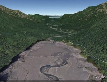
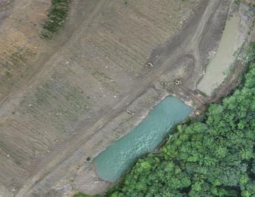
8 Elwha Dam Removal and River Restoration Olympic National Park, Washington Monitoring sediment volumes eroded from the reservoir and deposited downstream, where the mobile sediment can potentially affect salmon habitat 8
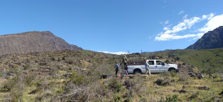
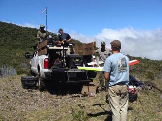
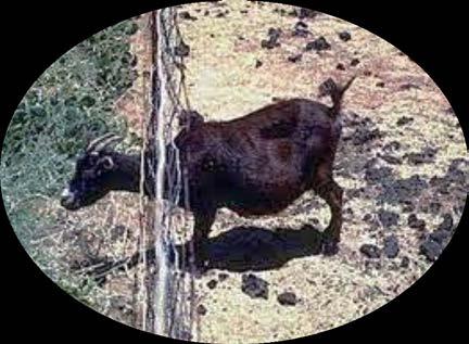

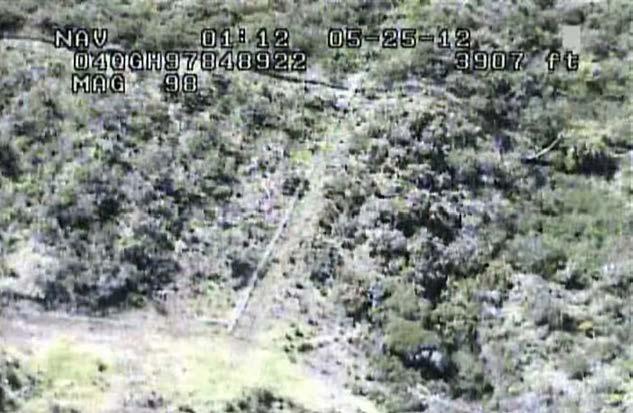

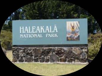
9 Boundary/Fenceline Inspections Haleakala National Park, Maui Infrastructure inspections maintaining 65 miles of fence line to exclude pigs, axis deer, predatory mammals, and invertebrate threats to the native resources 9


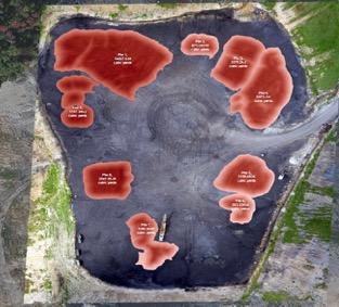
10 Mine Inspections West Virginia Highwall Potential drainage problems Drainage Control Structures Large surface features Mine permit inspections monitoring a range of topics: water quality, hazardous conditions, terrain topology, wildlife habitats, erosion, check dams, and post mining land use Excess Spoil Fills (aka Valley Fills) 10


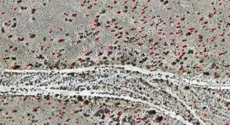
11 Pleistocene Trackway Mapping White Sands National Monument, NM Mammoth Trackway Photogrammetric documentation using a UAS to aerial survey extremely fragile fossilized footprints from the late Ice Age 11

12 Pleistocene Trackway Mapping White Sands National Monument, NM Story, et al


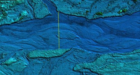
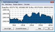
13 Missouri River Erosion Lower Brule, South Dakota 2012 Shoreline 2004 Shoreline Monitoring erosion rates of the Missouri River over a 7 mile stretch near Lower Brule. Stretches of the river have seen high rate of bank loss of up to 8 feet per year. 13


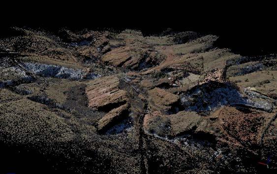
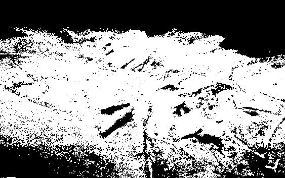
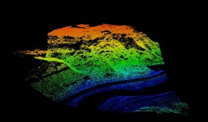
14 Debeque Landslide Debeque, Colorado Temporal series of Landslide models monitoring geomorphic processes. June 2013 October

 Green indicates possible")
15 Debeque Landslide Debeque, Colorado Point cloud comparison and calculations (using Cloud Compare) Green indicates possible movement 15


16 Archie Carr National Wildlife Refuge Nesting Sea Turtle Tracks Burgess, et al

17 Geospatial Data Products Color Infrared - NDVI Point Cloud Generation Elevation Models Feature Extraction KML 3D Modeling Orthophotography Volumetric Measurements Contour Generation 17
18 Summary Tangible benefits Science: UAS are far less disruptive to the environment and can carry high tech sensors, enabling UAS to gather repeatable, scientifically valid observations. Safety: DOI missions often expose personnel to significant safety hazards. From 1937 to 2000, 66% of all field biologist fatalities in DOI were aviationrelated. Savings: The cost to operate suas is about 10 percent of the cost to operate manned aircraft. Future Legal/Regulatory: FAA (suas rule, BLOS ops), State and Federal legislation Technology: Aircraft improvements (batteries), new & smaller sensors, processing software and ability to handle large data volumes Applications: More and varied, commercial services, collaborations, new integrated data products with other remote sensing and in situ data sets UAS will be a standard piece of field equipment for scientists 18
uas.usgs.gov John Fulton & Jeff Sloan USGS Denver, Colorado USA August 2016
 Department of the Interior USGS National Unmanned Aircraft Systems Project Office uas.usgs.gov John Fulton & Jeff Sloan USGS Denver, Colorado USA August 2016 1 UAS Basics Sources of Remote Sensing Data
MISSOURI LiDAR Stakeholders Meeting
 MISSOURI LiDAR Stakeholders Meeting East-West Gateway June 18, 2010 Tim Haithcoat Missouri GIO Enhanced Elevation Data What s different about it? Business requirements are changing.fast New data collection
USGS National Geospatial Program Understanding User Needs. Dick Vraga National Map Liaison for Federal Agencies July 2015
 + USGS National Geospatial Program Understanding User Needs Dick Vraga National Map Liaison for Federal Agencies July 2015 + Topics 2 Background Communities of Use User Surveys National Map Liaisons Partnerships
Subcommittee on Sedimentation Draft Sediment Analysis Guidelines for Dam Removal
 Subcommittee on Sedimentation Draft Sediment Analysis Guidelines for Dam Removal August 4, 2011 Jennifer Bountry, M.S., P.E. Tim Randle, M.S., P.E., D.WRE. Blair Greimann, Ph.D., P.E. Sedimentation and
USGS Hydrography Overview. May 9, 2018
 + 1 USGS Hydrography Overview May 9, 2018 + 2 The National Geospatial Program Provides the geospatial baseline of the Nation s topography, natural landscape and built environment through The National Map,
They include earthquakes, volcanic eruptions, floods, landslides, and other processes and occurrences. They are included in the broader concept of.
 They include earthquakes, volcanic eruptions, floods, landslides, and other processes and occurrences. They are included in the broader concept of. In general, natural processes are labeled hazardous only
P R O U D LY C A N A D I A N
 P R O U D LY C A N A D I A N 1.855.423.3185 info@rmegeomatics.com AERIAL SURVEYING IMAGING TERRAIN ANALYSIS WHO WE ARE HSE & REGULATORY CLIENT INDUSTRIES RME Geomatics (formerly NGF Geomatics) was founded
Esri Image & Mapping Forum 9 July 2017 Geiger-Mode for Conservation Planning & Design by USDA NRCS NGCE
 Esri Image & Mapping Forum 9 July 2017 Geiger-Mode for Conservation Planning & Design by USDA NRCS NGCE For over 75 years, the Natural Resources Conservation Service has been a pioneer in conservation,
Elwha River response to dam removals through four years and a big flood:
 Elwha River response to dam removals through four years and a big flood: Lessons learned, channel response, and sediment effects from the world s largest engineered dam removal Andy Ritchie NPS Elwha Restoration
3D Elevation Program, Lidar in Missouri. West Central Regional Advanced LiDAR Workshop Ray Fox
 3D Elevation Program, Lidar in Missouri West Central Regional Advanced LiDAR Workshop Ray Fox National Enhanced Elevation Assessment (Dewberry, 2011) Sponsored by the National Digital Elevation Program
Kootenai River Habitat Restoration Program Update
 Kootenai River Habitat Restoration Program Update Kootenai Tribe of Idaho Kootenai Valley Resource Initiative November 19, 2012 Bonners Ferry, Idaho Changes to Kootenai Basin Beaver trapping Floodplain
Geospatial Data, Services, and Products. National Surveying, mapping and geospatial conference
 Geospatial Data, Services, and Products Federal Programs -- USDA NRCS National Surveying, mapping and geospatial conference March 15, 2016 NRCS Applications using Geosaptial Products & Services Field
Progress on Defense-Related Uranium Mines Program
 Progress on Defense-Related Uranium Mines Program Russel Edge US Department of Energy (DOE) Office of Legacy Management (LM) John Elmer Navarro Research and Engineering, Inc., Contractor to LM Uranium
Assessment. Assessment
 2001 SPRINGBROOK CREEK RESTORATION - THREE YEAR POST-CONSTRUCTION REVIEW - Presented by Bruce Henderson and Andy Harris 2005 River Restoration Northwest Symposium Skamania Lodge, Washington www.hendersonlandservices.com
Regional Sediment Management
 Regional Sediment Management Linda S. Lillycrop Program Manager Coastal Engineer US Army Engineer Research and Development Center Coastal and Hydraulics Laboratory Q AVG Coastal Resilience: The Environmental,
RANGE SUSTAINABILITY GIS APPLICATIONS AND ENTERPRISE IMPLEMENTATIONS
 RANGE SUSTAINABILITY GIS APPLICATIONS AND ENTERPRISE IMPLEMENTATIONS May 4, 2009 Gabe Lovasz, Geospatial Analyst, ManTech SRS Molly Rodriguez, Geospatial Analyst, ManTech SRS -In Support of- The Office
Mapping Coastal Change Using LiDAR and Multispectral Imagery
 Mapping Coastal Change Using LiDAR and Multispectral Imagery Contributor: Patrick Collins, Technical Solutions Engineer Presented by TABLE OF CONTENTS Introduction... 1 Coastal Change... 1 Mapping Coastal
Emergency Planning. for the. Democratic National. Convention. imaging notes // Spring 2009 //
 Emergency Planning for the Democratic National Convention The DRAPP Demonstrates Partnership among Local, Regional, State, Utility and Federal Governments 14 imaging notes // Spring 2009 // www.imagingnotes.com
Grant Opportunity Monitoring Bi-State Sage-grouse Populations in Nevada
 Grant Opportunity Monitoring Bi-State Sage-grouse Populations in Nevada Proposals are due no later than November 13, 2015. Grant proposal and any questions should be directed to: Shawn Espinosa @ sepsinosa@ndow.org.
Science EOG Review: Landforms
 Mathematician Science EOG Review: Landforms Vocabulary Definition Term canyon deep, large, V- shaped valley formed by a river over millions of years of erosion; sometimes called gorges (example: Linville
Exploring the boundaries of your built and natural world. Geomatics
 Exploring the boundaries of your built and natural world Geomatics Before the Luxor brought magic to the Las Vegas strip and before the South LRT extension in Edmonton gave residents a new route to travel,
RANGE SUSTAINABILITY GIS APPLICATIONS AND ENTERPRISE IMPLEMENTATIONS
 RANGE SUSTAINABILITY GIS APPLICATIONS AND ENTERPRISE IMPLEMENTATIONS May 4, 2009 Gabe Lovasz, Geospatial Analyst, ManTech SRS Molly Rodriguez, Geospatial Analyst, ManTech SRS -In Support of- The Office
Layers (Layers in italics indicate group layers.) MyHazards MyPlan* Floods and Drought Landslides - USGS
 MyHazards MyPlan* Floods and Drought Landslides - USGS") MyHazards and MyPlan WebApps for Nevada Geohazards Over 100 hazard layers related to floods, fires, earthquakes, radon, and other supporting reference layers. Powerful educational and decision-making tools
MyHazards and MyPlan WebApps for Nevada Geohazards Over 100 hazard layers related to floods, fires, earthquakes, radon, and other supporting reference layers. Powerful educational and decision-making tools
Photogrammetric Ichnology: State-of-the-art Digital Data Analysis Of Paleontological Resources In North America, Europe, Asia, And Africa
 Photogrammetric Ichnology: State-of-the-art Digital Data Analysis Of Paleontological Resources In North America, Europe, Asia, And Africa Brent H. Breithaupt Wyoming State Office, Bureau of Land Management
Chapter 1 Overview of Maps
 Chapter 1 Overview of Maps In this chapter you will learn about: Key points when working with maps General types of maps Incident specific maps Map legend and symbols Map sources A map is a navigational
NATURAL FORCE THREATS, MONITORING AND RESEARCH NEEDS
 NATURAL FORCE THREATS, MONITORING AND RESEARCH NEEDS 1 Southern California Thomas Fire and Montecito Debris Flows 2 Timeline/Description of Conditions Between December 4, 2017 and January 12, 2018, over
Chapter 3 Erosion in the Las Vegas Wash
 Chapter 3 Erosion in the Las Vegas Wash Introduction As described in Chapter 1, the Las Vegas Wash (Wash) has experienced considerable change as a result of development of the Las Vegas Valley (Valley).
Physical Geography: Patterns, Processes, and Interactions, Grade 11, University/College Expectations
 Geographic Foundations: Space and Systems SSV.01 explain major theories of the origin and internal structure of the earth; Page 1 SSV.02 demonstrate an understanding of the principal features of the earth
Feasibility Study for Potential Removal of McLane & Goldman Dams Souhegan River, Milford, NH. Public Kick-off Meeting
 Feasibility Study for Potential Removal of McLane & Goldman Dams Souhegan River, Milford, NH Public Kick-off Meeting Mark Wamser Gomez and Sullivan Engineers, P.C. 603-428-4960 Aug 16, 2010 Agenda Opening
DEPARTMENT OF GEOLOGY AND MINERAL INDUSTRIES WAYS & MEANS SUBCOMMITTEE ON NATURAL RESOURCES MARCH 2, 2017
 DEPARTMENT OF GEOLOGY AND MINERAL INDUSTRIES WAYS & MEANS SUBCOMMITTEE ON NATURAL RESOURCES MARCH 2, 2017 1 ABOUT DOGAMI AGENCY MISSION, VISION & GOALS 2 Lidar image of a stream network along the Umpqua
TSEGI WASH 50% DESIGN REPORT
 TSEGI WASH 50% DESIGN REPORT 2/28/2014 Daniel Larson, Leticia Delgado, Jessica Carnes I Table of Contents Acknowledgements... IV 1.0 Project Description... 1 1.1 Purpose... 1 Figure 1. Erosion of a Headcut...
Tips for Success on a Test
 Number of Incorrect: Final Grade: Parent Signature: Top Tips for Success on a Test 1. Read the following statements at least two times. 2. Circle the key words in each question/ or statement. (*Remember
Weather Information for Surface Transportation (WIST): Update on Weather Impacts and WIST Progress
: Update on Weather Impacts and WIST Progress") Weather Information for Surface Transportation (WIST): Update on Weather Impacts and WIST Progress Samuel P. Williamson Office of the Federal Coordinator for Meteorological Services and Supporting Research
Weather Information for Surface Transportation (WIST): Update on Weather Impacts and WIST Progress Samuel P. Williamson Office of the Federal Coordinator for Meteorological Services and Supporting Research
GALVESTON BAY RSM Moving toward an Integrated, Cooperative, and Holistic Approach to Estuarine Sediments
 GALVESTON BAY RSM Moving toward an Integrated, Cooperative, and Holistic Approach to Estuarine Sediments RAE Conference 2010 Larry A. Wise Moffatt & Nichol RSM is a system-based approach for collaboratively
The 3D Elevation Program: Overview. Jason Stoker USGS National Geospatial Program ESRI 2015 UC
 + The 3D Elevation Program: Overview Jason Stoker USGS National Geospatial Program ESRI 2015 UC + 2 A little history USGS has a long, proud tradition of mapmaking (2009) + 3 The changing times Mapping
Geography is the study of the earth, it s land, it s people and it s environments. When you study geography, you should be looking at five distinct
 I.N pg. 9 Geography is the study of the earth, it s land, it s people and it s environments. When you study geography, you should be looking at five distinct themes. LOCATION PLACE REGION MOVEMENT HUMANENVIRONMENTAL
Catastrophic Events Impact on Ecosystems
 Catastrophic Events Impact on Ecosystems Hurricanes Hurricanes An intense, rotating oceanic weather system with sustained winds of at least 74 mph and a welldefined eye Conditions for formation: Warm water
Chesapeake Bay Remote Sensing Pilot Executive Briefing
 Chesapeake Bay Remote Sensing Pilot Executive Briefing Introduction In his Executive Order 13506 in May 2009, President Obama stated The Chesapeake Bay is a national treasure constituting the largest estuary
EO Information Services. Assessing Vulnerability in the metropolitan area of Rio de Janeiro (Floods & Landslides) Project
 Project") EO Information Services in support of Assessing Vulnerability in the metropolitan area of Rio de Janeiro (Floods & Landslides) Project Ricardo Armas, Critical Software SA Haris Kontoes, ISARS NOA World
EO Information Services in support of Assessing Vulnerability in the metropolitan area of Rio de Janeiro (Floods & Landslides) Project Ricardo Armas, Critical Software SA Haris Kontoes, ISARS NOA World
EAGLES NEST AND PIASA ISLANDS
 EAGLES NEST AND PIASA ISLANDS HABITAT REHABILITATION AND ENHANCEMENT PROJECT MADISON AND JERSEY COUNTIES, ILLINOIS ENVIRONMENTAL MANAGEMENT PROGRAM ST. LOUIS DISTRICT FACT SHEET I. LOCATION The proposed
Applying Hazard Maps to Urban Planning
 Applying Hazard Maps to Urban Planning September 10th, 2014 SAKAI Yuko Disaster Management Expert JICA Study Team for the Metro Cebu Roadmap Study on the Sustainable Urban Development 1 Contents 1. Outline
Tracy Fuller U. S. Geological Survey. February 24, 2016
 U. S. Geological Survey Arctic Elevation Data Involvement Statewide Alaska IfSAR Radar Collection Program Pan-Arctic Digital Elevation Map International Coordination Tracy Fuller U. S. Geological Survey
The Arctic Landscape Conservation Cooperative Conservation Goals
 The Arctic Landscape Conservation Cooperative Conservation Goals Adopted by the Arctic LCC Steering Committee, 24 August 2010 Background : Landscape Conservation Cooperatives and Climate Science Centers
Born in Unzen The World s First Unmanned Construction of Multilayer Sediment Control Dam Using Sediment Forms Unzen Restoration Project Office
 Born in Unzen The World s First Unmanned Construction of Multilayer Sediment Control Dam Using Sediment Forms Unzen Restoration Project Office Unzen Restoration Project Office Kyushu Regional Construction
Detecting Landscape Changes in High Latitude Environments Using Landsat Trend Analysis: 2. Classification
 1 Detecting Landscape Changes in High Latitude Environments Using Landsat Trend Analysis: 2. Classification Ian Olthof and Robert H. Fraser Canada Centre for Mapping and Earth Observation Natural Resources
GOAL 7 AREAS SUBJECT TO NATURAL DISASTERS AND HAZARDS. To protect life and property from natural disasters and hazards.
 GOAL 7 AREAS SUBJECT TO NATURAL DISASTERS AND HAZARDS A. GOALS: To protect life and property from natural disasters and hazards. B. POLICIES: 1. Floodplains shall be maintained as natural drainage-ways.
MEMORANDUM OF UNDERSTANDING. between the ASSOCIATION OF AMERICAN STATE GEOLOGISTS. and the U.S. DEPARTMENT OF THE INTERIOR OFFICE OF SURFACE MINING
 MEMORANDUM OF UNDERSTANDING between the ASSOCIATION OF AMERICAN STATE GEOLOGISTS and the U.S. DEPARTMENT OF THE INTERIOR OFFICE OF SURFACE MINING MEMORANDUM OF UNDERSTANDING between the ASSOCIATION OF
Statewide Topographic Mapping Program
 Statewide Topographic Mapping Program February 28, 2018 www.dotd.la.gov Outline Purpose of the Statewide Topographic Mapping Program History Breakdown of R.S. 48:36 - Topographic Mapping Statewide Topographic
Manitoba s Elevation (LiDAR) & Imagery Datasets. Acquisition Plans & Opportunities for Collaboration
 & Imagery Datasets. Acquisition Plans & Opportunities for Collaboration") Manitoba s Elevation (LiDAR) & Imagery Datasets Acquisition Plans & Opportunities for Collaboration Manitoba Planning Conference May 2017 Presentation Outline Manitoba s Elevation (LiDAR) and Imagery Datasets
Manitoba s Elevation (LiDAR) & Imagery Datasets Acquisition Plans & Opportunities for Collaboration Manitoba Planning Conference May 2017 Presentation Outline Manitoba s Elevation (LiDAR) and Imagery Datasets
Conference at a Glance
 Conference at a Glance 8:30 AM MONDAY ROOM 333 ROOM 327/328 ROOM 238 ROOM 296/298 WELCOME and KEYNOTE SPEAKER MICHAEL MILASKA 10 AM BREAK 10:30 AM Web Applications I 12 PM 1:30 PM Intro to R Data Science
Landslide Computer Modeling Potential
 Landslide Computer Modeling Potential Michael D. Dixon, P.E. Civil Engineer Payette National Forest The Payette National Forest selected the Stability Index Mapping (SINMAP) model for use in identifying
How Do Human Impacts and Geomorphological Responses Vary with Spatial Scale in the Streams and Rivers of the Illinois Basin?
 How Do Human Impacts and Geomorphological Responses Vary with Spatial Scale in the Streams and Rivers of the Illinois Basin? Bruce Rhoads Department of Geography University of Illinois at Urbana-Champaign
NCAR UCAR. 50 th Anniversary Lecture
 NCAR & UCAR 50 th Anniversary Lecture Turbulence, Wind Shear, Toxin Attacks, and Other Things That Go Bump In the Night: Applied Research for Real-Life Problems Bill Mahoney National Center for Atmospheric
U.S. Geological Survey Agency Briefing for MAPPS Mark L. DeMulder Director, National Geospatial Program. March 12, 2013
 + U.S. Geological Survey Agency Briefing for MAPPS Mark L. DeMulder Director, National Geospatial Program March 12, 2013 + 3D Elevation Program (3DEP) National Leadership The National Enhanced Elevation
ELEVATION IS FOUNDATIONAL. A DEM that is inaccurate or of poor resolution will pass those characteristics onto other data layers
 ELEVATION IS FOUNDATIONAL A DEM that is inaccurate or of poor resolution will pass those characteristics onto other data layers THE DEM IS FOUNDATIONAL TO ALL GIS (Geospatial Information System) LAYERS
A Regional Database Tracking Fire Footprint Each Year within the South Atlantic Region: Current Database Description and Future Directions
 A Regional Database Tracking Fire Footprint Each Year within the South Atlantic Region: Current Database Description and Future Directions Last Updated on September 30, 2018 Contributors: NatureServe,
Environment and Natural Resources Trust Fund 2019 Request for Proposals (RFP)
") Environment and Natural Resources Trust Fund 2019 Request for Proposals (RFP) Project Title: Data Visualization Tool for Minnesota Riverbed Habitat Category: A. Foundational Natural Resource Data and Information
Environment and Natural Resources Trust Fund 2019 Request for Proposals (RFP) Project Title: Data Visualization Tool for Minnesota Riverbed Habitat Category: A. Foundational Natural Resource Data and Information
Opportunities to Improve Ecological Functions of Floodplains and Reduce Flood Risk along Major Rivers in the Puget Sound Basin
 Opportunities to Improve Ecological Functions of Floodplains and Reduce Flood Risk along Major Rivers in the Puget Sound Basin Christopher Konrad, US Geological Survey Tim Beechie, NOAA Fisheries Managing
Examples of How Aerial Imagery Is Used in North Carolina. October 2007
 Examples of How Aerial Imagery Is Used in North Carolina October 2007 Table of Contributors Asheville Stormwater Utility Billing Camden County Tracking Permit Violations on Land Clearings CGIA Delineating
13.2 USING VIRTUAL GLOBES TO IMPROVE SITUATIONAL AWARENESS IN THE NATIONAL WEATHER SERVICE
 13.2 USING VIRTUAL GLOBES TO IMPROVE SITUATIONAL AWARENESS IN THE NATIONAL WEATHER SERVICE Andy Foster* National Weather Service Springfield, Missouri* Keith Stellman National Weather Service Shreveport,
Puakea, Hawaiÿi. Puakea, Hawaiÿi WATERSHED FEATURES
 Puakea, Hawaiÿi DAR Watershed Code: 85046 Puakea, Hawaiÿi WATERSHED FEATURES Puakea watershed occurs on the island of Hawaiÿi. The Hawaiian meaning of the name is white blossom. The area of the watershed
What s New in Topographic Information - USGS National Map
 + What s New in Topographic Information - USGS National Map SARGIS Workshop November 14, 2016 Rob Dollison, 703-648-5724 rdollison@usgs.gov + USGS 2 National Geospatial Program The National Geospatial
NCTCOG Regional GIS Meeting 6-Years and Going Strong. May 15, 2018 hosted by: Tarrant County
 NCTCOG Regional GIS Meeting 6-Years and Going Strong May 15, 2018 hosted by: Tarrant County Woolpert at a Glance 1911 Founded in Dayton, Ohio 25+ Offices across the nation 800+ Global employees 25+ OFFICES
Identifying, Understanding and Addressing Flood-Related Hazards
 Identifying, Understanding and Addressing Flood-Related Hazards Julie Moore, P.E. July 9, 2012 Agenda Traditional approach to river management Understanding flood-related hazards Common flood and flood
Bank Erosion and Morphology of the Kaskaskia River
 Bank Erosion and Morphology of the Kaskaskia River US Army Corps Of Engineers St. Louis District Fayette County Soil and Water Conservation District Team Partners : Carlyle Lake Ecosystem Partnership Vicinity
Restoring Rivers in Cumbria Online Story Map of a case study on the River Lyvennet
 Restoring Rivers in Cumbria Online Story Map of a case study on the River Lyvennet Summary This Story Map presents a river restoration case study for the River Eden Catchment, Cumbria. Students can learn
Adaptation to Sea Level Rise A Regional Approach
 Adaptation to Sea Level Rise A Regional Approach Project Partners: in Saco Bay, ME Peter Slovinsky, Marine Geologist Maine Geological Survey, Department of Conservation Project Funding from: Saco Bay Hazards
APPENDIX E. GEOMORPHOLOGICAL MONTORING REPORT Prepared by Steve Vrooman, Keystone Restoration Ecology September 2013
 APPENDIX E GEOMORPHOLOGICAL MONTORING REPORT Prepared by Steve Vrooman, Keystone Restoration Ecology September 2 Introduction Keystone Restoration Ecology (KRE) conducted geomorphological monitoring in
JALBTCX AND THE USACE NATIONAL COASTAL MAPPING PROGRAM
 JALBTCX AND THE USACE NATIONAL COASTAL MAPPING PROGRAM 237 237 237 217 217 217 200 200 200 80 119 27 252 174.59 1 255 255 255 0 0 0 163 163 163 131 132 122 239 65 53 110 135 120 112 92 56 62 102 130 102
Coastal Barrier Island Network (CBIN): Management strategies for the future
: Management strategies for the future") Coastal Barrier Island Network (CBIN): Management strategies for the future Heather Joesting*, Amy Williams**, Rusty Feagin**, and William K. Smith* *Department of Biology, Wake Forest University, Winston
Coastal Barrier Island Network (CBIN): Management strategies for the future Heather Joesting*, Amy Williams**, Rusty Feagin**, and William K. Smith* *Department of Biology, Wake Forest University, Winston
A Small Migrating Herd. Mapping Wildlife Distribution 1. Mapping Wildlife Distribution 2. Conservation & Reserve Management
 A Basic Introduction to Wildlife Mapping & Modeling ~~~~~~~~~~ Rev. Ronald J. Wasowski, C.S.C. Associate Professor of Environmental Science University of Portland Portland, Oregon 8 December 2015 Introduction
Geologic Hazards. Montour County Multi-jurisdictional. General. Earthquake
 Geologic Hazards General s are very rare in Pennsylvania and have caused little damage with no reported injuries or causalities. s that do occur in Pennsylvania happen deep within the Earth s crust. This
NOAA S Arctic Program in 2017
 NOAA S Arctic Program in 2017 NOAA s Arctic Mission To determine how the Arctic system is changing on time scales of weeks to decades, particularly with respect to the consequences that the loss of sea
Changes in Texas Ecoregions
 Comment On Lesson Changes in Texas Ecoregions The state of Texas can be divided into 10 distinct areas based on unique combinations of vegetation, topography, landforms, wildlife, soil, rock, climate,
Project (Project No. US-CA-62-2) Maintenance Inspection and Reports (Subtask 14.1) Inspection Report No.2
 Maintenance Inspection and Reports (Subtask 14.1) Inspection Report No.2") MEMORANDUM TO: FROM: Jim Well, Ducks Unlimited Mike Harvey, PhD, PG SUBJECT: M&T/ Llano Seco Fish Screen Project (Project No. US-CA-62-2) Maintenance Inspection and Reports (Subtask 14.1) Inspection Report
MEMORANDUM TO: FROM: Jim Well, Ducks Unlimited Mike Harvey, PhD, PG SUBJECT: M&T/ Llano Seco Fish Screen Project (Project No. US-CA-62-2) Maintenance Inspection and Reports (Subtask 14.1) Inspection Report
Remote Sensing and Incident Support. Department of Homeland Security February 22, 2013
 Remote Sensing and Incident Support Department of Homeland Security February 22, 2013 Introductions and Goals Today s Webcast will be Presented by: Chris Barnard DHS Remote Sensing Advisor Chris Vaughan
DISCUSSION PURPOSES ONLY C A L I F O R N I A S T A T E L A N D S C O M M I S S I O N
 C A L I F O R N I A S T A T E L A N D S C O M M I S S I O N SAN JOAQUIN RIVER REACH 2B OVERVIEW OF THE CALIFORNIA STATE LANDS COMMISSION ADMINISTRATIVE MAPS PRESENTATION Water Boundary Principles Best
Geotechnical Risks and Management Systems: An FHWA Perspective
 October 13, 2010 2010 STGE Conference Charleston, WV Geotechnical Risks and Management Systems: An FHWA Perspective Silas C. Nichols, PE, Senior Bridge Engineer - Geotechnical Federal Highway Administration
Template for Sediment and Erosion Control Plan General Instructions. Section Instructions
 Template for Sediment and Erosion Control Plan General Instructions Introduction: Soil erosion and sediment deposition from farmlands can contribute to degraded surface water quality. Sediment delivery
L OWER N OOKSACK R IVER P ROJECT: A LTERNATIVES A NALYSIS A PPENDIX A: H YDRAULIC M ODELING. PREPARED BY: LandC, etc, LLC
 L OWER N OOKSACK R IVER P ROJECT: A LTERNATIVES A NALYSIS A PPENDIX A: H YDRAULIC M ODELING PREPARED BY: LandC, etc, LLC TABLE OF CONTENTS 1 Introduction... 1 2 Methods... 1 2.1 Hydraulic Model... 1 2.2
NASA, partners track rain, snow in soggy Washington 10 November 2015, byphuong Le
 NASA, partners track rain, snow in soggy Washington 10 November 2015, byphuong Le David Wolff, a research scientist with NASA, poses for a photo Friday, Nov. 6, 2015, next to one of the large radar instruments
Wetlands and Riparian Mapping Framework Technical Meeting
 Wetlands and Riparian Mapping Framework Technical Meeting Meghan Burns Landscape Ecologist Linda Vance Senior Ecologist Why wetland and riparian mapping? Preliminary site assessment for the presence of
Summary of Available Datasets that are Relevant to Flood Risk Characterization
 Inter-Agency Characterization Workshop February 25-27, 2014 USACE Institute for Water Resources, Alexandria, VA, IWR Classroom Summary of Available Datasets that are Relevant to Characterization National
MONITORING AND MODELING NATURAL AND ANTHROPOGENIC TERRAIN CHANGE
 MONITORING AND MODELING NATURAL AND ANTHROPOGENIC TERRAIN CHANGE Spatial analysis and simulations of impact on landscape processess Helena MITASOVA, Russell S. HARMON, David BERNSTEIN, Jaroslav HOFIERKA,
Controlling Processes That Change Land
 1 Name Date Controlling Processes That Change Land People try to control some of the processes that change land. To do this, people apply technology- the use of science to solve problems in everyday life.
Earth History. What is the Earth s time scale? Geological time Scale. Pre-Cambrian. FOUR Eras
 The Earth is 4.6 billion years old! Earth History Mrs. Burkey ESS Cy Creek HS 17-18 If the Earth formed at midnight 6:00 am First life appears 10:00 pm First animals/plants on land 11:59 pm First humans
Georeferencing and Satellite Image Support: Lessons learned, Challenges and Opportunities
 Georeferencing and Satellite Image Support: Lessons learned, Challenges and Opportunities Shirish Ravan shirish.ravan@unoosa.org UN-SPIDER United Nations Office for Outer Space Affairs (UNOOSA) UN-SPIDER
Vegetation and Wildlife Habitat Mapping Study in the Upper and Middle Susitna Basin Study Plan Section 11.5
 (FERC No. 14241) Vegetation and Wildlife Habitat Mapping Study in the Upper and Middle Susitna Basin Study Plan Section 11.5 Initial Study Report Part C: Executive Summary and Section 7 Prepared for Prepared
Through their research, geographers gather a great deal of data about Canada.
 Ecozones What is an Ecozone? Through their research, geographers gather a great deal of data about Canada. To make sense of this information, they often organize and group areas with similar features.
Coastal Impacts of Climate Change in the Northwest: A Summary of the Findings of the upcoming National Climate Assessment
 Western Washington University Western CEDAR Salish Sea Ecosystem Conference 2014 Salish Sea Ecosystem Conference (Seattle, Wash.) May 1st, 3:30 PM - 5:00 PM Coastal Impacts of Climate Change in the Northwest:
Forest Service. Geospatial Management. Presented by: Carl Zulick, USFS Geospatial Information Officer. April 1, 2014
 Forest Service Geospatial Management Presented by: Carl Zulick, USFS Geospatial Information Officer April 1, 2014 USFS Mission "Caring for the Land and Serving People" The mission of the USDA Forest Service
Solutions to Flooding on Pescadero Creek Road
 Hydrology Hydraulics Geomorphology Design Field Services Photo courtesy Half Moon Bay Review Solutions to Flooding on Pescadero Creek Road Prepared for: San Mateo County Resource Conservation District
Summary Description Municipality of Anchorage. Anchorage Coastal Resource Atlas Project
 Summary Description Municipality of Anchorage Anchorage Coastal Resource Atlas Project By: Thede Tobish, MOA Planner; and Charlie Barnwell, MOA GIS Manager Introduction Local governments often struggle
Improvement of the National Hydrography Dataset for Parts of the Lower Colorado Region and Additional Areas of Importance to the DLCC
 Improvement of the National Hydrography Dataset for Parts of the Lower Colorado Region and Additional Areas of Importance to the DLCC Carlos Reyes-Andrade California State University, Northridge September
Eagle Creek Post Fire Erosion Hazard Analysis Using the WEPP Model. John Rogers & Lauren McKinney
 Eagle Creek Post Fire Erosion Hazard Analysis Using the WEPP Model John Rogers & Lauren McKinney Columbia River Gorge at Risk: Using LiDAR and GIS-based predictive modeling for regional-scale erosion susceptibility
Geomorphology Of The Chilliwack River Watershed Landform Mapping At North Cascades National Park Service Complex, Washington By National Park Service
 Geomorphology Of The Chilliwack River Watershed Landform Mapping At North Cascades National Park Service Complex, Washington By National Park Service READ ONLINE Snowshed contributions to the Nooksack
NAVAJO NATION PROFILE
 NAVAJO NATION PROFILE Largest land based area and federally recognized tribe in the United States Over 27,000 square miles (or 17.2 million acres with a population of over 300,000 people. Covers Arizona,
Subsidence and Sinkholes
 4.3.11 Subsidence and Sinkholes This section provides a profile and vulnerability assessment for the subsidence and sinkhole hazard for the Armstrong County Hazard Mitigation Plan (HMP). Two common causes
Island Design. UMRS EMP Regional Workshop. Presentation for the
 Island Design Presentation for the UMRS EMP Regional Workshop by Jon Hendrickson Hydraulic Engineer Regional Technical Specialist, Water Quality and Habitat Restoration August 17 19, 2005 Project Delivery
Learning Objectives: I can identify and interpret river flows and directions.
 Learning Objectives: I can identify and interpret river flows and directions. Bellringer Review: Check for Understanding Questions: 1 2 What Are The Key Parts Of A River s Anatomy? In your data notebooks