Photogrammetric Ichnology: State-of-the-art Digital Data Analysis Of Paleontological Resources In North America, Europe, Asia, And Africa
|
|
|
- Blaze Arnold
- 5 years ago
- Views:
Transcription


1 Photogrammetric Ichnology: State-of-the-art Digital Data Analysis Of Paleontological Resources In North America, Europe, Asia, And Africa Brent H. Breithaupt Wyoming State Office, Bureau of Land Management Neffra A. Matthews National Operations Center, Bureau of Land Management

2 U.S. Department of the Interior 2


3 U.S. Department of the Interior
4 U.S. DOI Bureau of Land Management 4


5 U.S. DOI Bureau of Land Management Manages 258 million surface acres 5

6 BLM lands comprise 13 percent of the total land surface of the United States and more than 40% of all land managed by the Federal Government.


7 Mission: Sustain the health, diversity and productivity of the public Rangeland lands for the use and enjoyment of present and future generations. Economic Development Irreplaceable Resources Wild Horses And Burro Recreation Threatened or Endangered Species 7

8 Omnibus Public Land Management Act Paleontological Resources Preservation - Formal recognition of the importance of paleontological resources from Federal lands. - The Secretaries of the Interior and Agriculture shall manage and protect paleontological resources on Federal lands using scientific principles and expertise. - Agencies must develop appropriate plans for inventory, monitoring, and the scientific and educational use of paleontological resources. - Agencies must establish a program to increase public awareness about the significance of a paleontological resources.

9

10

11


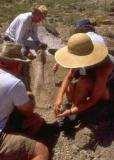
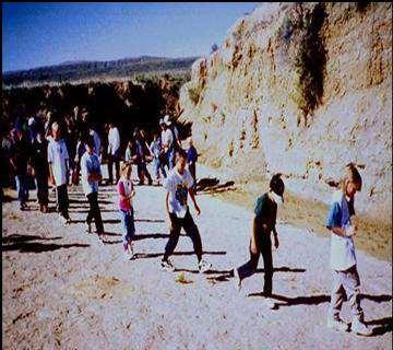
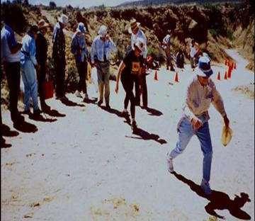
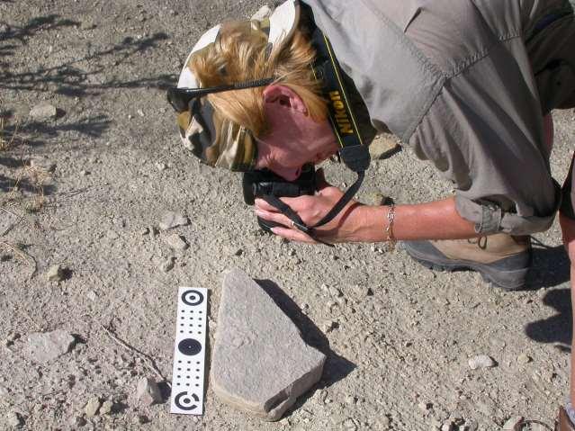
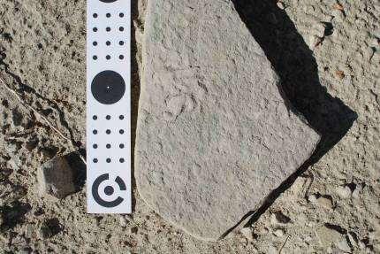
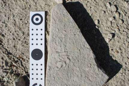
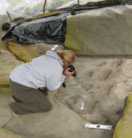
12 Traditional Measuring and Mapping


13 Dinosaur Behavior Dinosaur Growth and Development

14


15


16 Photogrammetry The art, science, and technology of obtaining reliable information about physical objects and the environment through the process of recording, measuring, and interpreting photographic images and patterns of electromagnetic radiant energy and other phenomena. Stereo Photo Overlap Area


17


18 90 90 Landscape Portrait 270


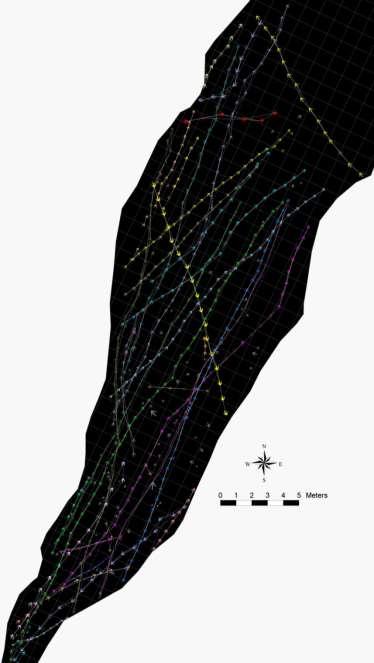
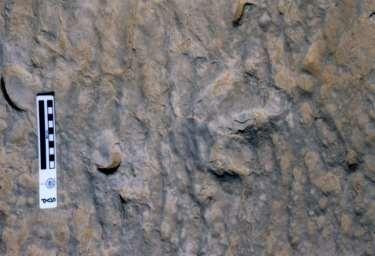
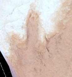
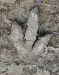
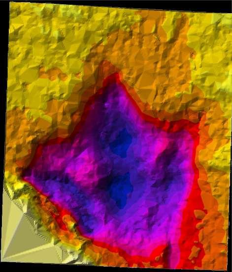
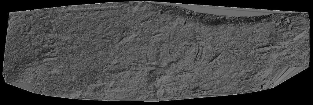
19 SEMINOE RESERVOIR TRACKSITE, WYOMING Upper Jurassic Sundance Formation Pioneering Photogrammetric documentation was done of this unique pterosaur and sauropod tracksite. Well-preserved trackways of the quadrapedal walking behavior of pterosaurs preserved and intensively documented.

20

21

22 Solid Models
23

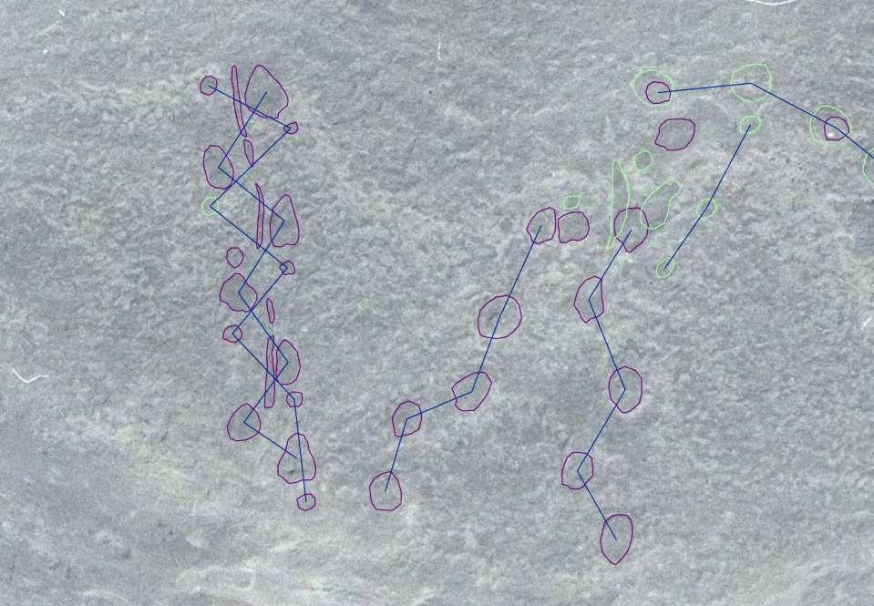
24


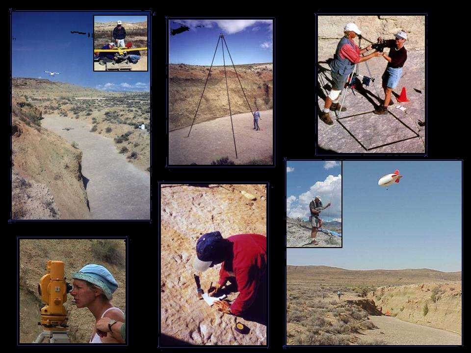
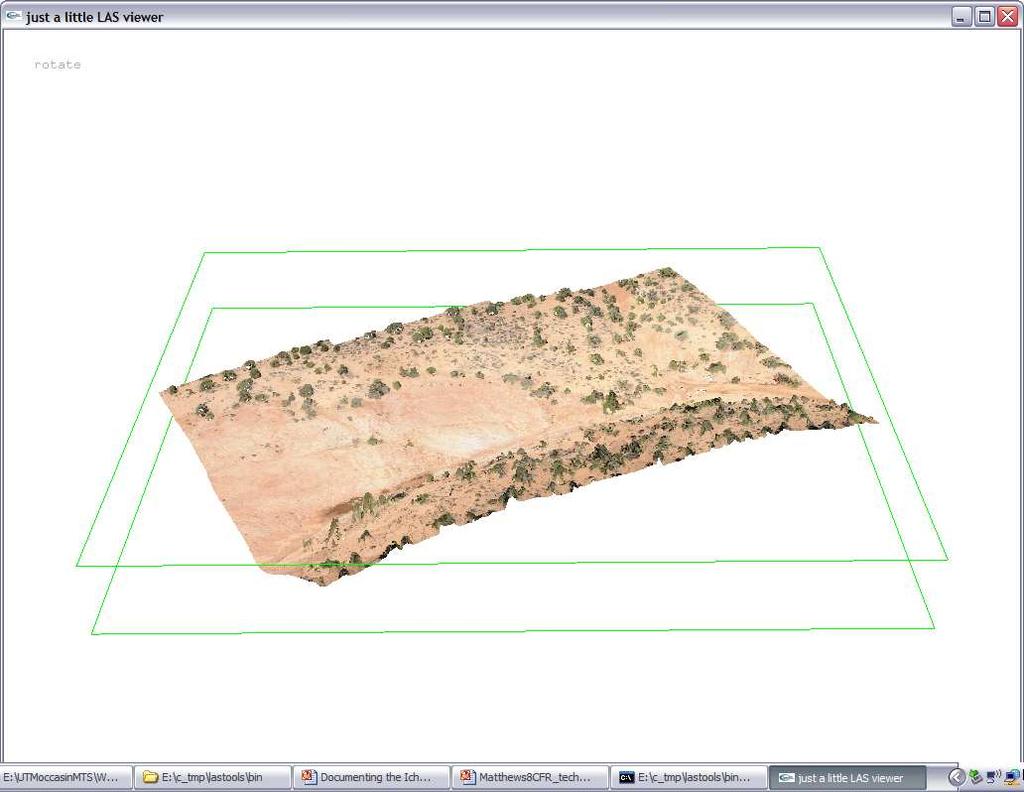
25 In 1998 Photogrammetry has rigorous requirements - A calibrated/metric Mapping Film Camera - Systematic Nader Stereoscopic Overlap of Photographs - Precise 3D coordinate control of the subject - Processing only on analytical stereoplotter designed for aerial photography completely manual process. Time from photo to terrain model: one footprint - approximately 1 week
 is used to calibrate and orient cameras.")

26 In 2001 a technological breakthrough 3D Measuring and Modeling software (PhotoModeler) is used to calibrate and orient cameras. This turns the camera into a surveying instrument. Automated 3D terrain extraction is conducted on the aerialdigital photogrammetric workstation.


27 2001 Photogrammetric Documentation begins at the Twentymile Wash Dinosaur Tracksite, Utah TWENTYMILE WASH DINOSAUR TRACKSITE

28 When first surveyed in 1998 ~300 tracks were reported. After photogrammetric mapping over 1000 dinosaur footprint impressions and associated traces were mapped in 3D space.


29 Twentymile Wash is one of the first tracksites to be mapped solely using a photogrammetric aerial-digital workstation.
30

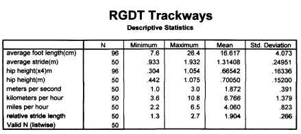
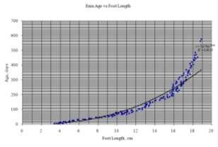
31 Trackway Analysis


32 2008 the Moccasin Mountain Tracksite, Utah is photographed from the ground and via helicopter Time from multiscale photos to terrain models: one tracksite - approximately 4 weeks.


33


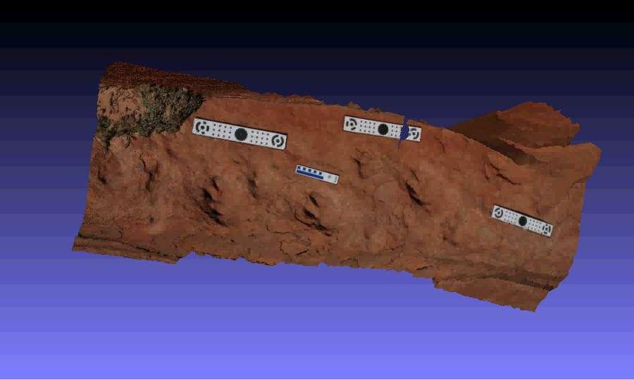
34 PREHISTORIC TRACKWAYS NATIONAL MONUMENT, NEW MEXICO Early Permian Robledo Mountain Formation Newly (2009) designated BLM national monument containing a unique diversity of Permian life traces of international importance. Photogrammetric documentation was done of select tracks and trackways of amphibians, reptiles, and insects done both in the field and in museum collections.

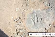
35
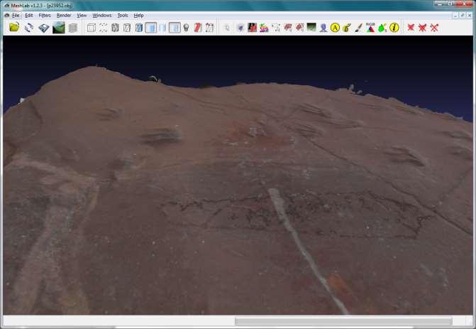
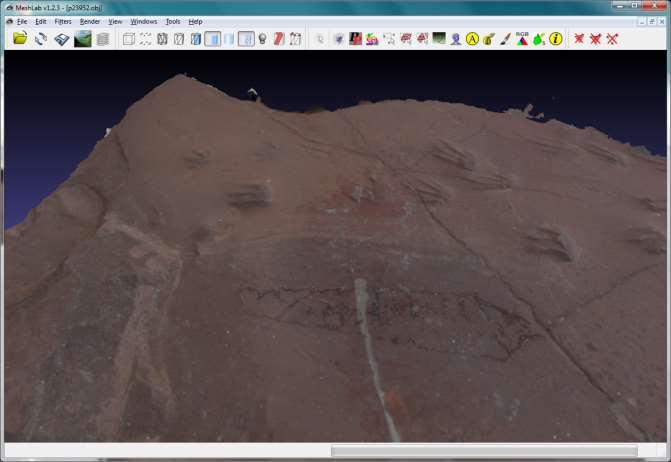


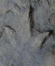
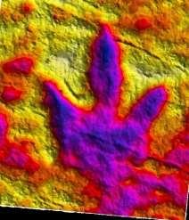
36


37 TROTTERNISH PENINSULA, ISLE OF SKYE, SCOTLAND Middle Jurassic Kimalaug Formation Photogrammetric documentation of some of the first dinosaur footprints found in Scotland. Data normalized and used for correlations of tracks of similar age, morphology, and preservation in western North America.
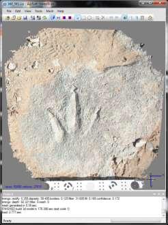
38
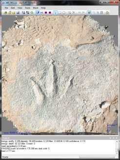
39


40


41


42


43 2010 the Mill Canyon Road Dinosaur Tracksite, Utah is photogrammetrically documented Time from photos to terrain models: one track area less than 1 day.


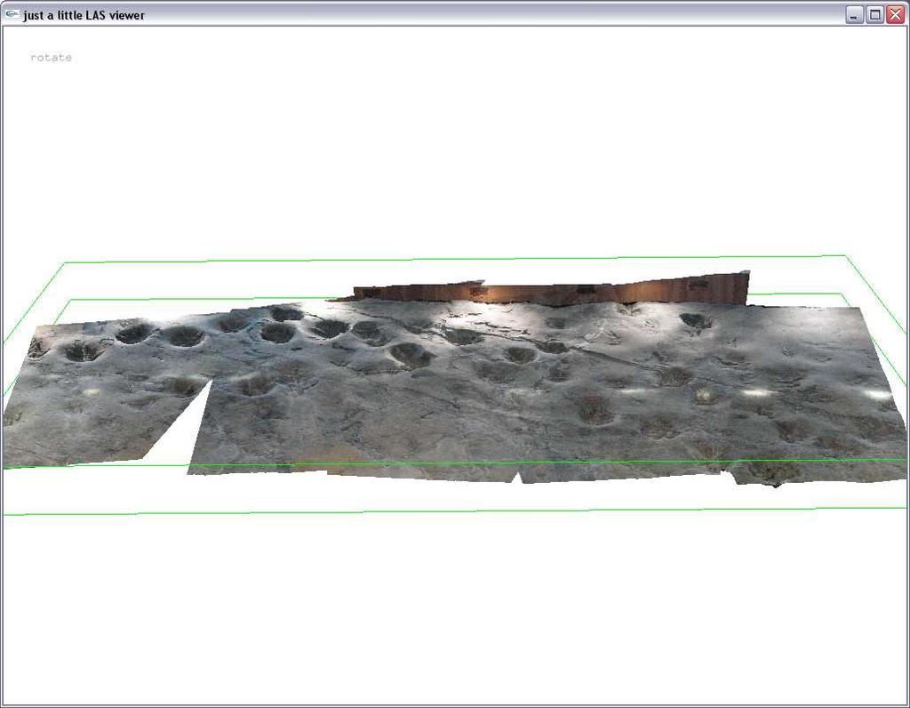
44 Raptor Track Area

45
46 Algorithmic rendering created from 3D surface normal information


47 Algorithmic rendering created from 3D surface normal information


48 PARIA CANYON-VERMILION CLIFFS WILDERNESS AND VERMILION CLIFFS NATIONAL MONUMENT, ARIZONA AND UTAH Lower Jurassic Navajo Sandstone Known for its geologic beauty, these areas are considered some of the premier canyon backpacking destinations in the world. Dinosaur tracksites preserve unique behavioral and preservational features of a desert fauna only preserved by traces. Preliminary reconnaissance photodocumentation of select areas was initiated in these areas, which will provide baseline data for future ichnological work and management decisions.
49


50 UHANGRI DINOSUR MUSEUM, HAENAM, SOUTH KOREA Upper Cretaceous Ubangi Formation Photogrammetric documentation was done of the unique preservational morphology of herbivorous dinosaur footprints for identification of sauropod or ornithopod characteristics.
51


52 TOADSTOOL GEOLOGIC PARK, NEBRASKA Oligocene Brule Formation Photogrammetric documentation was done at one of the most diverse Tertiary mammal tracksites, containing one of the longest known mammalian trackways. Documentation also included photogrammetry of the original, degrading rubber molds from the site, helping to preserve some of the original ichnological data.


53


54 TRACKING TECHNOLOGY 2010 Advances in structure from motion and muti-view matching result in a proliferation of available softwares which can be used to process overlapping images and produce terrain models. Apple introduces the ipad. Image Master Modeler Software


55 StereoScan = FREE Works with a single pair of overlapping (66%) of photographs Outputs include 3D pdf Time from photos to terrain model: one track - 15 minutes max.


56 Thank you for funding and/or logistical support to the Bureau of Land Management, National Park Service, United States Forest Service, Bureau of Reclamation, University of Wyoming, State of Wyoming, and all colleagues, volunteers, and resource managers who encouraged and helped facilitate the photogrammetric documentation of ichnological resources.
The Intermountain Region
 NATURAL RESOURCES Application of New Technologies Supporting Paleontological Resource Inventory and Monitoring in Intermountain Region Parks By: Vincent L. Santucci, National Park Service Geologic Resources
Progress on Defense-Related Uranium Mines Program
 Progress on Defense-Related Uranium Mines Program Russel Edge US Department of Energy (DOE) Office of Legacy Management (LM) John Elmer Navarro Research and Engineering, Inc., Contractor to LM Uranium
Unmanned Aircraft Systems (UAS) Activities in Earth Sciences
 Activities in Earth Sciences") Unmanned Aircraft Systems (UAS) Activities in Earth Sciences Bruce K. Quirk quirk@usgs.gov Department of the Interior U.S. Geological Survey June 22, 2015 Department of the Interior Bureau of Land Management
Unmanned Aircraft Systems (UAS) Activities in Earth Sciences Bruce K. Quirk quirk@usgs.gov Department of the Interior U.S. Geological Survey June 22, 2015 Department of the Interior Bureau of Land Management
Exploring the boundaries of your built and natural world. Geomatics
 Exploring the boundaries of your built and natural world Geomatics Before the Luxor brought magic to the Las Vegas strip and before the South LRT extension in Edmonton gave residents a new route to travel,
An Introduction to NatureServe Linking Conservation and Transportation Planning Phoenix, Arizona November 8 & 9, 2006
 An Introduction to NatureServe Linking Conservation and Transportation Planning Phoenix, Arizona November 8 & 9, 2006 1 NatureServe in Brief An independent, non-profit conservation organization Provides
Biodiversity: Facts and figures (tables from the report)
") Vascular plant * Country Number Australia 15,638 Brazil 56,215 China 8,200 Colombia 32,200 Congo, Democratic Republic 11,007 Costa Rica 12,119 Ecuador 19,362 India 18,664 Indonesia 29,375 Madagascar 9,505
Vascular plant * Country Number Australia 15,638 Brazil 56,215 China 8,200 Colombia 32,200 Congo, Democratic Republic 11,007 Costa Rica 12,119 Ecuador 19,362 India 18,664 Indonesia 29,375 Madagascar 9,505
Unit 5 Possible Test Questions Mesozoic and Cenozoic Eras HISTORICAL GEOLOGY
 Revised 8/16 Unit 5 Possible Test Questions Mesozoic and Cenozoic Eras HISTORICAL GEOLOGY Mesozoic Era Eons, Eras and Periods 1. List the Mesozoic periods in order (oldest to youngest). End of the Paleozoic
Bombing for Biodiversity in the United States: Response to Zentelis & Lindenmayer 2015
 CORRESPONDENCE Bombing for Biodiversity in the United States: Response to Zentelis & Lindenmayer 2015 Jocelyn L. Aycrigg 1, R. Travis Belote 2, Matthew S. Dietz 3, Gregory H. Aplet 4, & Richard A. Fischer
REQUEST FOR PROPOSALS
 GRANDE CACHE REGIONAL DINOSAUR TRACKS FOUNDATION REQUEST FOR PROPOSALS Grande Cache Regional Dinosaur Tracks Feasibility Study Box 300 Grande Cache, AB. T0E 0Y0 INTRODUCTION AND SUMMARY The ( Foundation
New dinosaur from Utah's red rocks 23 March 2010
 New dinosaur from Utah's red rocks 23 March 2010 journal produced by the Public Library of Science. The study was conducted by Joseph Sertich, a former University of Utah master's student and current Stony
Earth Science 105 Geologic Time Chapter 11
 Correlation of rock layers Earth Science 105 Geologic Time Chapter 11 Earth Science 11 th ed. Tarbuck & Lutgens Matching same age rocks In local area Across wide area In different regions Grand Canyon
Earth Science 105. Geologic Time Chapter 11. Earth Science 11 th ed. Tarbuck & Lutgens
 Earth Science 105 Geologic Time Chapter 11 Earth Science 11 th ed. Tarbuck & Lutgens Correlation of rock layers Matching same age rocks In local area Across wide area In different regions Grand Canyon
CE 59700: Digital Photogrammetric Systems
 CE 59700: Digital Photogrammetric Systems Fall 2016 1 Instructor: Contact Information Office: HAMP 4108 Tel: (765) 496-0173 E-mail: ahabib@purdue.edu Lectures (HAMP 2102): Monday, Wednesday & Friday (12:30
Presentation of the different land cover mapping activities in the French Guiana
 Presentation of the different land cover mapping activities in the French Guiana LCCS Land Cover Classification System 9 to 13 March 2015 Paramaribo - Suriname INTRODUCTION French Guiana : 8 046 427 ha
PSI Paleo Sleuth Investigation Grades 4-8
 PSI Paleo Sleuth Investigation Grades 4-8 Paleo Sleuth Investigations, or PSI, includes four activities to be used in succession that focus around fossils in Nebraska and the Ashfall Fossil Beds State
An Introduction to Day Two. Linking Conservation and Transportation Planning Lakewood, Colorado August 15-16, 16, 2006
 An Introduction to Day Two Linking Conservation and Transportation Planning Lakewood, Colorado August 15-16, 16, 2006 1 Agenda Day One Transportation Planning Heritage Program State Wildlife Action Plan
Fossils & The Geologic Time Scale
 Fossils & The Geologic Time Scale Fossils Preserved remains or traces of an organism that lived in the past. Fossils are formed when organisms die and are buried in sediment. Eventually the sediment builds
TSEGI WASH 50% DESIGN REPORT
 TSEGI WASH 50% DESIGN REPORT 2/28/2014 Daniel Larson, Leticia Delgado, Jessica Carnes I Table of Contents Acknowledgements... IV 1.0 Project Description... 1 1.1 Purpose... 1 Figure 1. Erosion of a Headcut...
Background. North Cascades Ecosystem Grizzly Bear Restoration Plan/ Environmental Impact Statement. Steve Rochetta
 Grizzly Bear Restoration Plan/ Environmental Impact Statement Steve Rochetta Background Situated in the core of the North Cascades ecosystem (NCE), the North Cascades National Park Complex is surrounded
9. Parashant Dark Sky Park Light Management Plan (LMP)
") 9. Parashant Dark Sky Park Light Management Plan (LMP) Introduction: Grand Canyon-Parashant National Monument encompasses over a million acres, including joint federal agencies, Arizona state lands, and
9. Parashant Dark Sky Park Light Management Plan (LMP) Introduction: Grand Canyon-Parashant National Monument encompasses over a million acres, including joint federal agencies, Arizona state lands, and
G E N E R A L S C I E N C E N O T E S
 G E N E R A L S C I E N C E N O T E S INCOMPLETE ECOSYSTEMS By Ariel A. Roth, Geoscience Research Institute WHAT THIS ARTICLE IS ABOUT Animals depend on plants as a source for food. Without food animals
Agate Fossil Beds National Monument
 University of Nebraska - Lincoln DigitalCommons@University of Nebraska - Lincoln U.S. National Park Service Publications and Papers National Park Service 2014 Follow this and additional works at: http://digitalcommons.unl.edu/natlpark
AGI Geoscience Outreach Programs with the National Park Service
 AGI Geoscience Outreach Programs with the National Park Service M. RAY THOMASSON 1, JUDY GENIAC 2, ROBERT HIGGINS 2 1 -THOMASSON PARTNER ASSOCIATES, INC. 2 -NATIONAL PARK SERVICE Every individual should
What can I do with a major in Earth Information Science?
 Lewis-Clark State College offers a Bachelor of Arts or Science Degree in Earth Information Science through the Natural Sciences and Mathematics Division. You can learn more about the Natural Sciences and
Hazard Mapping Along the Dead Sea Shoreline
 FIG Working Week in Marrakech, Morocco 18-22 May 2011 Hazard Mapping Along the Dead Sea Shoreline Rami Al-Ruzouq, Abdullah Al-Zuobi, AbdEl-Rahman Abueladas, Emad Akkawi Department of Surveying and Geomatics
A Regional Database Tracking Fire Footprint Each Year within the South Atlantic Region: Current Database Description and Future Directions
 A Regional Database Tracking Fire Footprint Each Year within the South Atlantic Region: Current Database Description and Future Directions Last Updated on September 30, 2018 Contributors: NatureServe,
Heritage Southwest: Program Summary
 Heritage Southwest: Program Summary The Center for Desert Archaeology s Heritage Southwest program is building a network that spans the American Southwest, Mexican Northwest, and beyond to promote creative
Stevns Klint SITE INFORMATION. IUCN Conservation Outlook Assessment 2014 (archived) Finalised on 27 October 2014
 Finalised on 27 October 2014") IUCN Conservation Outlook Assessment 2014 (archived) Finalised on 27 October 2014 Please note: this is an archived Conservation Outlook Assessment for Stevns Klint. To access the most up-to-date Conservation
IUCN Conservation Outlook Assessment 2014 (archived) Finalised on 27 October 2014 Please note: this is an archived Conservation Outlook Assessment for Stevns Klint. To access the most up-to-date Conservation
Geospatial Data Model for Archaeology Site Data
 Authors: David T. Hansen, Barbara D. Simpson, Anastasia Leigh, Patrick Welch, and Lorri Peltz-Lewis Geospatial Data Model for Archaeology Site Data Presented by David T. Hansen and Barbara D. Simpson at
UNITED STATES DEPARTMENT OF THE INTERIOR BUREAU OF LAND MANAGEMENT MANUAL TRANSMITTAL SHEET
 Form 1221-2 (June 1969) Subject UNITED STATES DEPARTMENT OF THE INTERIOR BUREAU OF LAND MANAGEMENT MANUAL TRANSMITTAL SHEET Release 8-68 Date 1. Explanation of Material Transmitted: This release transmits
GEOMATICS. Shaping our world. A company of
 GEOMATICS Shaping our world A company of OUR EXPERTISE Geomatics Geomatics plays a mayor role in hydropower, land and water resources, urban development, transport & mobility, renewable energy, and infrastructure
Addendum to November 2009 Vantage EA
 Addendum to November 2009 Vantage EA Introduction This document includes additional information, supplemental to that already provided within the Vantage Energy Uintah LLC Ashley National Forest Oil and
Sullivan et al., eds., 2011, Fossil Record 3. New Mexico Museum of Natural History and Science, Bulletin 53.
 316 Sullivan et al., eds., 2011, Fossil Record 3. New Mexico Museum of Natural History and Science, Bulletin 53. THEROPOD- AND PROSAUROPOD-DOMINATED ICHNOFAUNAS FROM THE NAVAJO-NUGGET SANDSTONE (LOWER
The Role of the Geoscientist in the U.S. Federal Government*
 The Role of the Geoscientist in the U.S. Federal Government* Brenda Pierce 1 Search and Discovery Article #120006 (2009) Posted November 20, 2009 *Adapted from presentation at AAPG Geoscience Technology
Lecture 9: Reference Maps & Aerial Photography
 Lecture 9: Reference Maps & Aerial Photography I. Overview of Reference and Topographic Maps There are two basic types of maps? Reference Maps - General purpose maps & Thematic Maps - maps made for a specific
Atlas of the Upper Gila River Watershed
 Atlas of the Upper Gila River Watershed Katie Banister, David Chan, Jessica M. Driscoll, Christopher Fullerton, Aaron Lien and Kelly Mott Lacroix January 2014 The University of Arizona Water Resources
Chapter : 1 : Introduction of GIS
 History of GIS : Chapter : 1 : Introduction of GIS In 1960 the Department of Forestry and Rural Department of Canada has decided to pursue a large-scale project to manage the resources. The initial task
Friends of Petrified Forest National Park
 I S S U E 2, N O V E M B E R 2 0 1 2 Friends of Petrified Forest National Park Working together we can make a difference! Revueltosaurus Quarry, June 2012. Exceptional Findings at Petrified Forest National
MOR SEAWAY TEACHERS. A CHANGING LANDSCAPE Activity Overview BIG IDEA
 MOR SEAWAY 03 Activity Overview BIG IDEA The Earth and its landscapes change over time. Scientists use the fossil record to understand the Earth s environments and climates millions of years ago. OBJECTIVE
DEPARTMENT OF GEOGRAPHY B.A. PROGRAMME COURSE DESCRIPTION
 DEPARTMENT OF GEOGRAPHY B.A. PROGRAMME COURSE DESCRIPTION (3 Cr. Hrs) (2340100) Geography of Jordan (University Requirement) This Course pursues the following objectives: - The study the physical geographical
Locational business intelligence in the U.S. Forest Service: Geospatial Accomplishment Reporting ESRI USER CONFERENCE 2015 JULY 21, 2015
 Locational business intelligence in the U.S. Forest Service: Geospatial Accomplishment Reporting ESRI USER CONFERENCE 2015 JULY 21, 2015 Agenda Introduction to the US Forest Service Why geo-enable Performance
SOLUTIONS ADVANCED GIS. TekMindz are developing innovative solutions that integrate geographic information with niche business applications.
 ADVANCED GIS SOLUTIONS TekMindz are developing innovative solutions that integrate geographic information with niche business applications. TEK INDZ TM GIS Services Overview At the leading edge of geospatial
BISTI / DE-NA-ZIN WILDERNESS
 BISTI / DE-NA-ZIN WILDERNESS Activities: Facilities: Season / Hours: Description: Hiking and photography. No electrical hookups, water, or restrooms are available. Open year-round. The Bisti/De-Na-Zin
Application for Geotourism Charter
 Application for Geotourism Charter Thank you for the interest in geotourism as a long-term strategy to foster wisely managed tourism and enlightened destination stewardship. National Geographic s Center
NAVAJO NATION PROFILE
 NAVAJO NATION PROFILE Largest land based area and federally recognized tribe in the United States Over 27,000 square miles (or 17.2 million acres with a population of over 300,000 people. Covers Arizona,
Chapter 1 Overview of Maps
 Chapter 1 Overview of Maps In this chapter you will learn about: Key points when working with maps General types of maps Incident specific maps Map legend and symbols Map sources A map is a navigational
Geologic Time. Mr. Skirbst
 Geologic Time Mr. Skirbst Geologic Time Geologic Time Scale Describing and dividing major events of Earth s history Like a timeline of your life! Birth Like a timeline of your life! Like a timeline of
GEOGRAPHY (GEOGRPHY) Geography (GEOGRPHY) 1
 Geography (GEOGRPHY) 1") Geography (GEOGRPHY) 1 GEOGRAPHY (GEOGRPHY) GEOGRPHY 1040 Planet Earth 4 Credits The features of the natural environment (lithosphere, atmosphere and hydrosphere); their character, distribution, origin
Geography (GEOGRPHY) 1 GEOGRAPHY (GEOGRPHY) GEOGRPHY 1040 Planet Earth 4 Credits The features of the natural environment (lithosphere, atmosphere and hydrosphere); their character, distribution, origin
Unmanned Aerial Systems (UAS) Innovation for affordable, improved and accelerated spatial data acquisition
 Innovation for affordable, improved and accelerated spatial data acquisition") Unmanned Aerial Systems (UAS) Innovation for affordable, improved and accelerated spatial data acquisition Kathrine Kelm, The World Bank Rumyana Tonchovska, FAO Walter Volkmann, Micro Aerial Projects,
Unmanned Aerial Systems (UAS) Innovation for affordable, improved and accelerated spatial data acquisition Kathrine Kelm, The World Bank Rumyana Tonchovska, FAO Walter Volkmann, Micro Aerial Projects,
THE CADASTRAL INFORMATION SYSTEM IN THE REPUBLIC OP SOUTH AFRICA
 I $:? Distr.: LIMITED ECA/NRD/CART.9/ORG.27 November 1996 Original: ENGLISH Ninth United Nations Regional Cartographic Conference for Africa Addis Ababa, Ethiopia 11-15 November 1996 THE CADASTRAL INFORMATION
June 5, 2014 BOARD MATTER F-10. Annual Reporting for Non-Exclusive Scientific Fossil Removal Permit FSP-00331S INFORMATIONAL ONLY
 June 5, 2014 BOARD MATTER F-10 ACTION: AUTHORITY: Annual Reporting for Non-Exclusive Scientific Fossil Removal Permit FSP-00331S INFORMATIONAL ONLY W.S. 36-1-114; Board of Land Commissioners Rules and
Arizona Recreation Map By Benchmark Maps READ ONLINE
 Arizona Recreation Map By Benchmark Maps READ ONLINE Families can come and see what the Sierra Montana Recreation Center has to offer. The center has a game room with Xbox 360s on high definition TV's,
[LLAZC X.L EA0000; AZ SRP ] Notice of Temporary Closures: Selected Public Lands in La Paz County, AZ
![[LLAZC X.L EA0000; AZ SRP ] Notice of Temporary Closures: Selected Public Lands in La Paz County, AZ](/thumbs/89/100188672.jpg "[LLAZC X.L EA0000; AZ SRP ] Notice of Temporary Closures: Selected Public Lands in La Paz County, AZ") This document is scheduled to be published in the Federal Register on 12/29/2017 and available online at https://federalregister.gov/d/2017-28217, and on FDsys.gov 4310-32 DEPARTMENT OF THE INTERIOR Bureau
This document is scheduled to be published in the Federal Register on 12/29/2017 and available online at https://federalregister.gov/d/2017-28217, and on FDsys.gov 4310-32 DEPARTMENT OF THE INTERIOR Bureau
Development of the Portal of Cultural Heritage Objects the Kingdom of Poland
 Evgeny KOVALEV, Natalia KOVALEVA Sholokhov Moscow State University for the Humanities, Russia Hadi SALEH Vladimir State University Named After Alexander and Nikolay Stoletovs, Russia Development of the
Internet GIS Sites. 2 OakMapper webgis Application
 Internet GIS Sites # Name URL Description 1 City of Sugar Land http://www.sugarlandtx.gov/index.htm It is a city in Texas with 65,000 Residents. The City of Sugar Land, Texas, provides ArcIMS-based maps
Al Ain Cultural Heritage Management Strategy 1/102
 AL AIN CULTURAL HERITAGE MANAGEMENT STRATEGY EXECUTIVE SUMMARY The cultural heritage of Al Ain is rich and varied; it consists of tangible and intangible resources and incorporates archaeological sites,
Clues to the Past. Grades 6-8 Educational Program Guide
 Clues to the Past Grades 6-8 Educational Program Guide OAS Science Practices: 1, 2, 3, 4, 6, 7, 8 Program Overview The Clues to the Past program will introduce students to several 300 million years old
History & Scope of Remote Sensing FOUNDATIONS
 History & Scope of Remote Sensing FOUNDATIONS Lecture Overview Introduction Overview of visual information Power of imagery Definition What is remote sensing? Definition standard for class History of Remote
Arizona Highways, May 1948 (Petrified Forest National Park) (Vol. 24, No. 5)
 (Vol. 24, No. 5)") Arizona Highways, May 1948 (Petrified Forest National Park) (Vol. 24, No. 5) If searched for a book Arizona Highways, May 1948 (Petrified Forest National Park) (Vol. 24, No. 5) in pdf format, in that case
Arizona Highways, May 1948 (Petrified Forest National Park) (Vol. 24, No. 5) If searched for a book Arizona Highways, May 1948 (Petrified Forest National Park) (Vol. 24, No. 5) in pdf format, in that case
Ecological Monitoring District Lead Multiple Locations in Nevada
 Ecological Monitoring District Lead Multiple Locations in Nevada Great Basin Institute and Bureau of Land Management Ecological Monitoring District Lead Multiple Locations in Nevada The ecological monitoring
5 Time Marches On. TAKE A LOOK 1. Identify What kinds of organisms formed the fossils in the picture?
 CHAPTER 6 5 Time Marches On SECTION The Rock and Fossil Record BEFORE YOU READ After you read this section, you should be able to answer these questions: How do geologists measure time? How has life changed
The Significance of the Fossil Record ( Susan Matthews and Graeme Lindbeck)
") The Significance of the Fossil Record ( Susan Matthews and Graeme Lindbeck) The fossil record indicates the evolutionary history of life. Many events together, including: continental drift, changes in
The Significance of the Fossil Record ( Susan Matthews and Graeme Lindbeck) The fossil record indicates the evolutionary history of life. Many events together, including: continental drift, changes in
Summary Description Municipality of Anchorage. Anchorage Coastal Resource Atlas Project
 Summary Description Municipality of Anchorage Anchorage Coastal Resource Atlas Project By: Thede Tobish, MOA Planner; and Charlie Barnwell, MOA GIS Manager Introduction Local governments often struggle
A Guide to Life on Earth
 A Guide to Life on Earth Introductory Activity circa 1-2 periods Main Activity circa 1period Conclusion circa 1 period Activity covers English, Science, ICT and Geography Overview In this activity, pupils
The Road to Data in Baltimore
 Creating a parcel level database from high resolution imagery By Austin Troy and Weiqi Zhou University of Vermont, Rubenstein School of Natural Resources State and local planning agencies are increasingly
Spanish national plan for land observation: new collaborative production system in Europe
 ADVANCE UNEDITED VERSION UNITED NATIONS E/CONF.103/5/Add.1 Economic and Social Affairs 9 July 2013 Tenth United Nations Regional Cartographic Conference for the Americas New York, 19-23, August 2013 Item
Chapter 1: Introduction to Safety and Ethics
 Core Curriculum Standards Met by Each Chapter On the Right Trail meets Utah s Social Studies Core Curriculum Standards for grades 3-7. Each chapter has specific standard objectives, which are met by the
Evaluating Urban Vegetation Cover Using LiDAR and High Resolution Imagery
 Evaluating Urban Vegetation Cover Using LiDAR and High Resolution Imagery Y.A. Ayad and D. C. Mendez Clarion University of Pennsylvania Abstract One of the key planning factors in urban and built up environments
WELCOME & INTRODUCTION
 MPA Management Capacity Building Training Module 1: WELCOME & INTRODUCTION Participants Distinguished Guests Welcome Site Overviews of MPAs represented Overview of Training Program What are Today s Objectives?
Portfolio of karteco Cadastral Survey Department
 Portfolio of karteco Cadastral Survey Department 01-2016 Who we are? karteco Environmental & Energy Engineering Consultancy Founding members: Apostolos Karteris Dr. Environmental Engineer Marinos Karteris
RANGE SUSTAINABILITY GIS APPLICATIONS AND ENTERPRISE IMPLEMENTATIONS
 RANGE SUSTAINABILITY GIS APPLICATIONS AND ENTERPRISE IMPLEMENTATIONS May 4, 2009 Gabe Lovasz, Geospatial Analyst, ManTech SRS Molly Rodriguez, Geospatial Analyst, ManTech SRS -In Support of- The Office
A Trip Through Geologic Time
 Date Class _ A Trip Through Geologic Time Chapter Test A Multiple Choice Write the letter of the correct answer on the line at the left. 1. Late in the Paleozoic Era, the supercontinent Pangaea formed.
United States Department of the Interior NATIONAL PARK SERVICE Northeast Region
 United States Department of the Interior NATIONAL PARK SERVICE Northeast Region June 17, 2017 REQUEST FOR STATEMENTS OF INTEREST and QUALIFICATIONS Project Title: ASSESSMENT OF NATURAL RESOURCE CONDITION
Coastal Engineering Survey Services
 Coastal Engineering Survey Services Engineering The Coastline We have created world-class ports and sustainable coastal environments, sculpting shorelines and enhancing land values. Our reclamation work
COMMUNITY SERVICE AREA
 INSTITUTE FOR TRIBAL ENVIRONMENTAL PROFESSIONALS Tribal Waste and Response Assistance Program (TWRAP) Developing and Implementing a Tribal Integrated Solid Waste Management Plan April 12-14, 2016 Palm
GENERAL FOSSIL INFORMATION
 GENERAL FOSSIL INFORMATION Invertebrate Fossils of Kansas http://www.kgs.ku.edu/publications/pic/pic24.html Invertebrate Fossils Kentucky Geological Society http://www.uky.edu/kgs/fossils/invertebrate.htm
Heritage and Cultural Tourism Management
 Unit 34: Heritage and Cultural Tourism Management Unit code: L/601/1757 QCF level: 4 Credit value: 15 Aim The aim of this unit is to enable learners to gain understanding of the heritage and cultural,
PROPOSED CONCEPT. Chapter 2
 Chapter 2 PROPOSED CONCEPT One of the most important tasks in building a National Heritage Area is conceptualizing it in sufficient detail. Questions that must be answered include: What are the underlying
1.1 What is Site Fingerprinting?
 Site Fingerprinting Utilizing GIS/GPS Technology 1.1 What is Site Fingerprinting? Site fingerprinting is a planning tool used to design communities where protection of natural resources is the primary
CRETACEOUS ALBERTA SCIENCE HALL. 1. This exhibit is based on a discovery made in
 Worksheet Level 3 p. 1 CRETACEOUS ALBERTA 1. This exhibit is based on a discovery made in 2. What type of dinosaur was found at this site, how many individuals were there, and what was their age range?
Distribution and Significance of Mesozoic Vertebrate Trace Fossils in Dinosaur National Monument
 University of Wyoming National Park Service Research Center Annual Report Volume 16 16th Annual Report, 1992 Article 12 1-1-1992 Distribution and Significance of Mesozoic Vertebrate Trace Fossils in Dinosaur
Louisiana Transportation Engineering Conference. Monday, February 12, 2007
 Louisiana Transportation Engineering Conference Monday, February 12, 2007 Agenda Project Background Goal of EIS Why Use GIS? What is GIS? How used on this Project Other site selection tools I-69 Corridor
Natural Resource Condition Assessments. Everglades National Park and Big Cypress National Preserve 2015
 Natural Resource Condition Assessments Everglades National Park and Big Cypress National Preserve 2015 Greater Everglades Ecosystem Restoration Conference- 4/23/2015 The Information Pyramid. Data and information
Arizona Museum of Natural History
 GCC Geology AZMNH Extra Credit (v. 3, 8/16/17) Page 1 of 5 Arizona Museum of Natural History 53 N. Macdonald, Mesa, AZ 85201, 480-644-2230 Discounted entrance fee for students WITH ID. Attach your receipt
Pierce Cedar Creek Institute GIS Development Final Report. Grand Valley State University
 Pierce Cedar Creek Institute GIS Development Final Report Grand Valley State University Major Goals of Project The two primary goals of the project were to provide Matt VanPortfliet, GVSU student, the
Rainforests and Deserts: Distribution, Uses, and Human Influences. Teacher s Masters California Education and the Environment Initiative
 E Teacher s Masters California Education and the Environment Initiative Earth Science Standard E.5.e. Rainforests and Deserts: Distribution, Uses, and Human Influences California Education and the Environment
GIS Changing the World GIS Day November 15, 2017
 + GIS Changing the World GIS Day November 15, 2017 + Growing Up On The Farm 3 Geographic Information in DNR A 75 year history of mapping and GIS. Forest type map from 1944. State of Washington - Division
Ecological Land Cover Classification For a Natural Resources Inventory in the Kansas City Region, USA
 Ecological Land Cover Classification For a Natural Resources Inventory in the Kansas City Region, USA by Applied Ecological Services, Inc. In cooperation with the Mid-America Regional Council 600 Broadway,
DEPARTMENT OF GEOLOGY AND MINERAL INDUSTRIES WAYS & MEANS SUBCOMMITTEE ON NATURAL RESOURCES MARCH 2, 2017
 DEPARTMENT OF GEOLOGY AND MINERAL INDUSTRIES WAYS & MEANS SUBCOMMITTEE ON NATURAL RESOURCES MARCH 2, 2017 1 ABOUT DOGAMI AGENCY MISSION, VISION & GOALS 2 Lidar image of a stream network along the Umpqua
Rock cycle diagram. Relative dating. Placing rocks and events in proper sequence of formation Deciphering Earth s history from clues in the rocks
 Geologic Time Rock cycle diagram Leaves of History Chapter 21 Modern geology Uniformitarianism Fundamental principle of geology "The present is the key to the past Relative dating Placing rocks and events
Eyes in the Sky & Data Analysis.
 Eyes in the Sky & Data Analysis How can we collect Information about Earth Climbing up Trees & Mountains Gathering Food Self Protection Understanding Surroundings By Travelling Collected Information Converted
Huron Creek Watershed 2005 Land Use Map
 Huron Creek Watershed 2005 Land Use Map Created By: Linda Kersten, 12/20/06 Created For: MTU Introduction to GIS Class (FW 5550) The Huron Creek Watershed Advisory Committee Michigan Technological University,
Committee. Dr. Dyckman, chair Professor Sperry
 A PLAN FOR DESIGNATING PRIMITIVE CAMPING AREAS IN THE ESCALANTE CANYONS SPECIAL RECREATION MANAGEMENT AREA OF THE GRAND STAIRCASE-ESCALANTE NATIONAL MONUMENT Benjamin Fields Committee 2 Dr. Dyckman, chair
DOWNLOAD OR READ : MAPS OF MANY LANDS A NEW PICTURE ATLAS FOR YOUNG CHILDRENCHILDRENS PICTURE BIBLE PDF EBOOK EPUB MOBI
 DOWNLOAD OR READ : MAPS OF MANY LANDS A NEW PICTURE ATLAS FOR YOUNG CHILDRENCHILDRENS PICTURE BIBLE PDF EBOOK EPUB MOBI Page 1 Page 2 maps of many lands pdf PGC > Hunt & Trap > State Game Lands > State
Tales of the Past. Source: Sci-ber Text with the Utah State Office of Education
 Tales of the Past Source: Sci-ber Text with the Utah State Office of Education http://www.uen.org/core/science/sciber/trb4/downloads/literacy4.pdf Do you like mystery and intrigue? Do you like to do detective
McHenry County Property Search Sources of Information
 Disclaimer: The information in this system may contain inaccuracies or typographical errors. The information in this system is a digital representation of information derived from original documents; as
Chapter: Clues to Earth s Past
 Table of Contents Chapter: Clues to Earth s Past Section : Section 2: Relative Ages of Rocks Section 3: Absolute Ages of Rocks Traces of the Distant Past Paleontologists, scientists who study fossils,
MOR TIME TEACHERS. ONCE UPON A TIME Activity Overview BIG IDEA
 MOR TIME 04 Activity Overview BIG IDEA OBJECTIVE BACKGROUND The geologic time scale can be challenging for students to understand. This activity explores how scientists divide the Earth s long history
Distribution and Significance of Mesozoic Vertebrate Trace Fossils in Dinosaur National Monument
 University of Wyoming National Park Service Research Center Annual Report Volume 15 15th Annual Report, 1991 Article 16 1-1-1991 Distribution and Significance of Mesozoic Vertebrate Trace Fossils in Dinosaur
Strategies for biodiversity conservation
 Institute of Earth Systems University of Malta Strategies for biodiversity conservation Louis F. Cassar PhD Elisabeth Conrad PhD The conservation imperative: perspective Biodiversity hotspot High endemism