Committee. Dr. Dyckman, chair Professor Sperry
|
|
|
- Rodger Carroll
- 5 years ago
- Views:
Transcription


1 A PLAN FOR DESIGNATING PRIMITIVE CAMPING AREAS IN THE ESCALANTE CANYONS SPECIAL RECREATION MANAGEMENT AREA OF THE GRAND STAIRCASE-ESCALANTE NATIONAL MONUMENT Benjamin Fields
2 Committee 2 Dr. Dyckman, chair Professor Sperry
3 Outline 3 Introduction Problem Statement Background Research Objective Literature Review Methodology Conclusion References
4 4 INTRODUCTION
5 PROBLEM STATEMENT 5 In the Grand Staircase-Escalante National Monument (GSENM) Management Plan of 2001, the Bureau of Land Management (BLM) is directed to designate primitive camping areas. While the Management Plan defines the designation of primitive camping areas as an Immediate Action to be completed within one year of the Management Plan s release (BLM, 2001, p. 68), to this date none have been designated.
 GSENM")
6 BACKGROUND 6 GSENM was designated by Presidential Proclamation in 1996 as the BLM s first National Monument 1.87 Million Acres in Southern Utah Purpose is to protect the area s vast scientific and historic resources Monument lands are to remain in an undeveloped frontier state (BLM, 2001) GSENM Management Plan has been in use since February, 2001 Source: New York Times

7 Management Zones 7 Determine the range of permitted activities and facilities Four Management Zones Frontcountry Passage Outback Primitive Wilderness Study Areas (WSAs)
 were identified by the Management Plan as needing more intensive recreation")
8 Special Recreation Management Areas 8 Seven Special Recreation Management Areas (SRMAs) were identified by the Management Plan as needing more intensive recreation management

9 Escalante Canyons SRMA 9 Easternmost quarter of the Monument 470,000 acres 222,000 acres are Wilderness Study Areas Several important archaeological, historic, and prehistoric sites SRMA that sees the most use High demand for designated camping areas
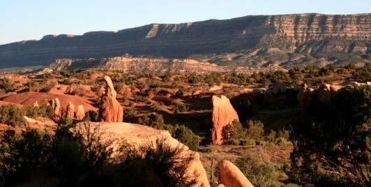


10 Landscapes of ECSRMA 10 Source: Ben Fields
11 Camping in GSENM 11 Three developed campgrounds Frontcountry and Passage Zones Allowed only in designated camping areas Outback and Primitive Zones Dispersed camping Designated camping areas can be added if needed Currently, campers are choosing campsites on an ad hoc basis regardless of Management Zone
12 What are designated primitive 12 camping areas? Undeveloped areas designated by the BLM as appropriate for overnight use by individuals or groups Large enough to accommodate 2-5 vehicles, with a few areas large enough for groups Designated by a small sign and barriers Facilities and amenities are not provided Must be in place for Frontcountry and Passage Zones Allowed, but not required, for Outback and Primitive Zones (BLM, 2001)
13 Research Objective 13 This objective of this Terminal Project is to create a plan for locating designated primitive camping areas in ECSRMA in a manner that will properly protect scientific and historic resources.
14 14 LITERATURE REVIEW

15 GSENM Management Plan Directives 15 Define many aspects of designated camping areas Location and access factors Management Zones Roads open to the public Areas of existing use Facilities Number and size NEPA considerations Source: Ben Fields
16 Planning and Managing Multiple Uses 16 Public land managers and planners operating under multiple-use guidelines must: Protect natural resources Manage traditional uses (mining, grazing, etc.) Provide recreation opportunities Debate over public land and resource uses has led to a systems approach (Wilson, 2008) Resources are treated as individual systems Stakeholder groups are segmented into resource use spheres Demand certain uses based on their own unique social values, expectations, and preferences (Mann and Absher, 2007)
17 Multiple-Use Recreation Planning 17 The most common approach to multiple-use recreation planning is the zoning approach (Nilsen and Tyler, 1997) First developed for the US Forest Service as the Recreation Opportunity Spectrum (ROS) by Clark and Stankey (1979) ROS basic tenets Individuals engage in recreational activities to fulfill a desired outcome Recreation managers should provide settings to deliver desired recreational outcomes Regional, agency, or landscape scale
18 ROS Framework 18 Recreational opportunity setting classes Modern, semimodern, semiprimitive, primitive Setting indicators Access (system and level of difficulty) Other non-recreational uses Site management (extent, complexity, facilities) Number of social encounters Visitor impacts (degree and prevalence of impacts) Acceptable regimentation (permitted uses) Managers should try and provide as many recreational settings and opportunities as possible
19 ROS Recreational Settings and ECSRMA 19 Modern Fully developed campgrounds with facilities and amenities in the towns of Escalante and Boulder Semimodern GSENM developed campgrounds with minimal facilities and no amenities Semiprimitive Designated camping areas Primitive Outback and Primitive Management Zones allow dispersed backcountry camping
 Significant impacts occur with initial and low levels of use, then level off use increases (Cole, 1987; Marion and Cole,")
20 Camping Impacts 20 Usually localized to a small percentage of the protected area (Leung and Marion, 2000) The most commonly cited impacts are related to soils, vegetation, water, and wildlife (Cole and Landres, 1995; Hammitt and Cole, 1998; Cole, 2004; Leung and Marion, 2000) Significant impacts occur with initial and low levels of use, then level off use increases (Cole, 1987; Marion and Cole, 1996; Leung and Marion, 2000) Source: Ben Fields
21 Impact Management 21 Campsite containment strategies (ie., designated camping areas) are highly successful in minimizing the overall extent of impacts by restricting the number and size of campsites to as few as possible to fill demand Shenandoah National Park (Reid and Marion, 2004) Isle Royale National Park (Marion and Farrell, 2004)
22 GIS Land-Use Suitability Analysis 22 Aims to identify the most appropriate spatial pattern, area, or site for a particular land use according to specific inputs (Collins et al., 2001) Allows for multiple factors to be analyzed simultaneously using different scenarios (Steiner et al., 2000) Inputs are defined, manipulated, arranged, and weighted according to their suitability and relative importance for a certain activity (Malczewski, 2004) Type and number of inputs are determined by the situation and desired outcome (Basnet and Apan, 2007)
23 GIS-based Recreation Suitability Analysis 23 Used extensively by public land managers and recreation planners to locate the most appropriate areas for certain types of recreation Location factors are to include: Landscape features (water features, topography, ground cover, hazards, etc.) Accessibility features (facilities, infrastructure, travel distance) Site management features (permitted uses) Visitor behaviors and demands Positive and negative (prohibited) factors (Levinsohn et al., 1987; Brandli and Ulmer, 2001; Gul et al., 2006)
24 Research Objective 24 This objective of this Terminal Project s is to create a plan for locating designated primitive camping areas in ECSRMA in a manner that will properly protect scientific and historic resources.
25 25 METHODOLOGY
26 Steps of the Methodology Define and weigh camping area location factors using GSENM Management Plan directives and Literature Review findings Land classification GSENM Management Zone WSAs (negative factor) Physical landscape Floodplain, riparian areas (negative factor) Ground cover Slope Access Open public roads Distance from road Visitor behavior and demands Existing camping areas given priority Proximity to popular recreation destinations
27 Steps of the Methodology, contd Perform a GIS suitability analysis to determine the most appropriate camping area locations 3. Recommend implementation procedures
28 Conclusion 28 Designated camping areas are needed for GSENM ECSRMA is the area in most need of designated camping areas This project will provide a solid foundation for designating camping areas in ECSRMA The process used in this Terminal Project can then be applied to other designating camping areas in other GSENM SRMAs
29 References 29 Basnet, B.B., & Apan, A.A. (2007). Degree of site suitability measurement in a GIS: The effect of standardization method. MODSIM Conference, December 2007, Christchurch, new Zealand. Brandli, U.B., & Ulmer, U. (2001). Recreational function. In P. Brassel, H. Lischke (eds.), Swiss National Forest inventory: Methods and models of the second assessment. Swiss Federal Research Institute WSL, Birmensdorf, pp Bureau of Land Management. (1999). Grand Staircase-Escalante National Monument Approved Management Plan and Record of Decision. Cedar City, UT: USDI Bureau of Land Management. Clark, R.N., & Stankey, G. (1979).The recreation opportunity spectrum: A framework for planning, management and research ( Gen. Tech. Rep. GTR-PNW-98). Portland, OR: USDA Forest Service, Pacific Northwest Forest Experiment Station. Cole, D.N. (1987). Research on soil and vegetation in wilderness: A state-of-knowledge review (General Technical Report INT-220). Ogden, UT: USDA Forest Service, Intermountain Research Station. Collins, M.G., Steiner, F.R., & Rushman, M.J. (2001) Land-use suitability analysis in the United States: Historical development and promising technological achievements. Environmental Management, 28(5),
30 References, contd. 30 Gul, A., Orucu, K.M., & Karaca, O.Z. (2006). An approach for recreation suitability analysis to recreation planning in Golcuk Nature Park. Environmental Management, 37(5), Leung, Y.F., & Marion, J.L. (2000a). Recreation Impacts and Management in Wilderness: A State-of-Knowledge Review. In: Cole, David N.; McCool, Stephen F.; Borrie, William T.; O Loughlin, Jennifer, comps Wilderness science in a time of change conference Volume 5: Wilderness ecosystems, threats, and management; 1999 May 23-27; Missoula, MT. Proceedings RMRS-P-15-VOL-5. Ogden, UT: U.S. Department of Agriculture, Forest Service, Rocky Mountain Research Station. Levinsohn, A., Langford, G., Rayner, M., Rintoul, J., & Eccles, R. (1987). A micro-computer based GIS for assessing recreation suitability. In: Proceedings of GIS 87, American Society for Photogrammetry and Remote Sensing, Falls Church, VA, pp Malczewski, J. (2004). GIS-based land-use suitability analysis: A critical overview. Progress in Planning, 62, Mann, C., & Absher, J.D. (2007). A two stage analysis of recreation conflict as a basis for management strategies in the Black Forest: A methodological contribution. Forest and Snow Landscape Research, 81 ½, Marion, J.L., & Cole, D.N. (1996). Spatial and temporal variation in soil and vegetation impacts on campsites. Ecological Applications, 6,
31 References, contd. 31 Marion, J.L., & Farrell, T.A. (2002). Management practices that concentrate visitor activities: Camping impact management at Isle Royale National Park, USA. Journal of Environmental Management, 66, Nilsen, P., & Tayler, G A Comparative Analysis of Protected Area Planning and Management Frameworks (General Technical Report INT-GTR-371). Ogden, UT: USDA Forest Service, Rocky Mountain Research Station. Reid, S. E., & Marion, J.L. (2004). Effectiveness of a confinement strategy for reducing campsite impacts in Shenandoah National Park. Environmental Conservation, 31(4), Steiner, F., McSherry, L., & Cohen, J. (2000). Land suitability analysis for the Upper Gila River watershed. Landscape and Urban Planning, 50, Wilson, P.I. (2008). Preservation versus motorized recreation: Institutions, history, and public lands management. The Social Science Journal, 45,
Human-Caused Fires: An Exploratory Pattern Analysis
 Human-Caused Fires: An Exploratory Pattern Analysis J E N A F E R R A R E S E N I C H O L A S J O N E S D I G I T A L C O M P I L A T I O N A N D D A T A B A S E D E S I G N P O R T L A N D S T A T E U
9. Parashant Dark Sky Park Light Management Plan (LMP)
") 9. Parashant Dark Sky Park Light Management Plan (LMP) Introduction: Grand Canyon-Parashant National Monument encompasses over a million acres, including joint federal agencies, Arizona state lands, and
9. Parashant Dark Sky Park Light Management Plan (LMP) Introduction: Grand Canyon-Parashant National Monument encompasses over a million acres, including joint federal agencies, Arizona state lands, and
Background. North Cascades Ecosystem Grizzly Bear Restoration Plan/ Environmental Impact Statement. Steve Rochetta
 Grizzly Bear Restoration Plan/ Environmental Impact Statement Steve Rochetta Background Situated in the core of the North Cascades ecosystem (NCE), the North Cascades National Park Complex is surrounded
Summary Description Municipality of Anchorage. Anchorage Coastal Resource Atlas Project
 Summary Description Municipality of Anchorage Anchorage Coastal Resource Atlas Project By: Thede Tobish, MOA Planner; and Charlie Barnwell, MOA GIS Manager Introduction Local governments often struggle
ASSESSING AND EVALUATING RECREATION RESOURCE IMPACTS: SPATIAL ANALYTICAL APPROACHES. Yu-Fai Leung
 ASSESSING AND EVALUATING RECREATION RESOURCE IMPACTS: SPATIAL ANALYTICAL APPROACHES by Yu-Fai Leung Dissertation submitted to the Faculty of the Virginia Polytechnic Institute and State University in partial
An Assessment of Recreation Impacts in Alpine and Subalpine Areas of Grand Teton National Park: Preliminary Findings
 University of Wyoming National Park Service Research Center Annual Report Volume 32 32nd Annual Report, 2009 Article 6 1-1-2009 An Assessment of Recreation Impacts in Alpine and Subalpine Areas of Grand
Topographic Recreational Map Of New Mexico: Detailed Travel Map By GTR Mapping
 Topographic Recreational Map Of New Mexico: Detailed Travel Map By GTR Mapping Biological Assessment for Proposed Reconstruction of New Mexico Forest Highway 12. Cuba and Jemez Recreation Opportunity Spectrum
HORIZON 2030: Land Use & Transportation November 2005
 PROJECTS Land Use An important component of the Horizon transportation planning process involved reviewing the area s comprehensive land use plans to ensure consistency between them and the longrange transportation
GIS Data and Technology to Support Transportation & MPO Decision-Making & Planning. using an Eco-Logical* Approach within the Kansas City Region
 GIS Data and Technology to Support Transportation & MPO Decision-Making & Planning using an Eco-Logical* Approach within the Kansas City Region Authors (in alphabetical order): Tom Gerend, Tom Jacobs,
Assessing Interconnections Between Wilderness and Adjacent Lands: The Grand Staircase-Escalante National Monument, Utah
 Assessing Interconnections Between Wilderness and Adjacent Lands: The Grand Staircase-Escalante Monument, Utah Janice L. Thomson Dawn A. Hartley Gregory H. Aplet Peter A. Morton Abstract Wilderness managers
PERCEPTIONS OF RELATIVE ATTRACTIVENESS OF NATURE-BASED TOURISM ASSETS: A COMPARISON BETWEEN CVB DIRECTORS AND VISITORS
 PERCEPTIONS OF RELATIVE ATTRACTIVENESS OF NATURE-BASED TOURISM ASSETS: A COMPARISON BETWEEN CVB DIRECTORS AND VISITORS Jinyang Deng, Ph.D. Recreation, Parks, and Tourism Resources Program West Virginia
Chapter 6. Fundamentals of GIS-Based Data Analysis for Decision Support. Table 6.1. Spatial Data Transformations by Geospatial Data Types
 Chapter 6 Fundamentals of GIS-Based Data Analysis for Decision Support FROM: Points Lines Polygons Fields Table 6.1. Spatial Data Transformations by Geospatial Data Types TO: Points Lines Polygons Fields
Study Group Theme Comments for Missionary And Lakes: Columbine Meeting 2/22/'05
 Theme Area #: 172 Study Group Theme s for And : Columbine Meeting 2/22/'05 theme 3 would better accommodate existing uses 3 does not seem very limited even though you say it's more natural Consider changing
Monitoring Visitor Impacts in Coastal National Parks: A Review of Techniques
 Introduction Coastal areas, particularly sandy coasts and barrier islands, are prime destinations for outdoor recreation activities, yet the same zones possess diverse, dynamic, and, often, sensitive ecosystems
Understanding Land Use and Walk Behavior in Utah
 Understanding Land Use and Walk Behavior in Utah 15 th TRB National Transportation Planning Applications Conference Callie New GIS Analyst + Planner STUDY AREA STUDY AREA 11 statistical areas (2010 census)
Heritage and Cultural Tourism Management
 Unit 34: Heritage and Cultural Tourism Management Unit code: L/601/1757 QCF level: 4 Credit value: 15 Aim The aim of this unit is to enable learners to gain understanding of the heritage and cultural,
Atlas of the Upper Gila River Watershed
 Atlas of the Upper Gila River Watershed Katie Banister, David Chan, Jessica M. Driscoll, Christopher Fullerton, Aaron Lien and Kelly Mott Lacroix January 2014 The University of Arizona Water Resources
International Dark Sky Park Designation Annual Report Nomination Package
 International Dark Sky Park Designation Parashant International International Night Night Sky Sky Province Province 2017 Annual Report Nomination Package April 2014 Prepared by Eathan McIntyre Physical
A NATIONAL WILDERNESS PRESERVATION SYSTEM DATABASE: BENEFITS, LIMITATIONS, AND FUTURE NEEDS* Shannon Meyer and Peter Landres
 A NATIONAL WILDERNESS PRESERVATION SYSTEM DATABASE: BENEFITS, LIMITATIONS, AND FUTURE NEEDS* Shannon Meyer and Peter Landres Aldo Leopold Wilderness Research Institute Rocky Mountain Research Station USDA
The Arctic Landscape Conservation Cooperative Conservation Goals
 The Arctic Landscape Conservation Cooperative Conservation Goals Adopted by the Arctic LCC Steering Committee, 24 August 2010 Background : Landscape Conservation Cooperatives and Climate Science Centers
California Urban and Biodiversity Analysis (CURBA) Model
 Model") California Urban and Biodiversity Analysis (CURBA) Model Presentation Overview Model Overview Urban Growth Model Policy Simulation and Evaluation Model Habitat Fragmentation Analysis Case Study: Santa
California Urban and Biodiversity Analysis (CURBA) Model Presentation Overview Model Overview Urban Growth Model Policy Simulation and Evaluation Model Habitat Fragmentation Analysis Case Study: Santa
Local Area Key Issues Paper No. 13: Southern Hinterland townships growth opportunities
 Draft Sunshine Coast Planning Scheme Review of Submissions Local Area Key Issues Paper No. 13: Southern Hinterland townships growth opportunities Key Issue: Growth opportunities for Southern Hinterland
The Road to Data in Baltimore
 Creating a parcel level database from high resolution imagery By Austin Troy and Weiqi Zhou University of Vermont, Rubenstein School of Natural Resources State and local planning agencies are increasingly
Developed new methodologies for mapping and characterizing suburban sprawl in the Northeastern Forests
 Development of Functional Ecological Indicators of Suburban Sprawl for the Northeastern Forest Landscape Principal Investigator: Austin Troy UVM, Rubenstein School of Environment and Natural Resources
WELCOME & INTRODUCTION
 MPA Management Capacity Building Training Module 1: WELCOME & INTRODUCTION Participants Distinguished Guests Welcome Site Overviews of MPAs represented Overview of Training Program What are Today s Objectives?
Transport Planning in Large Scale Housing Developments. David Knight
 Transport Planning in Large Scale Housing Developments David Knight Large Scale Housing Developments No longer creating great urban spaces in the UK (Hall 2014) Transport Planning Transport planning processes
Canada Land Inventory (CLI) CANADA LAND INVENTORY LEVEL-I LAT/LONG DIGITAL DATA LAND CAPABILITY FOR RECREATION. 1.0 Coverage Specifications
 CANADA LAND INVENTORY LEVEL-I LAT/LONG DIGITAL DATA LAND CAPABILITY FOR RECREATION. 1.0 Coverage Specifications") Canada Land Inventory (CLI) CANADA LAND INVENTORY LEVEL-I LAT/LONG DIGITAL DATA LAND CAPABILITY FOR RECREATION 1.0 Coverage Specifications Original Map Scale: 1:250,000 Resolution :.00024414 of a degree
Canada Land Inventory (CLI) CANADA LAND INVENTORY LEVEL-I LAT/LONG DIGITAL DATA LAND CAPABILITY FOR RECREATION 1.0 Coverage Specifications Original Map Scale: 1:250,000 Resolution :.00024414 of a degree
DEPARTMENT OF GEOLOGY AND MINERAL INDUSTRIES WAYS & MEANS SUBCOMMITTEE ON NATURAL RESOURCES MARCH 2, 2017
 DEPARTMENT OF GEOLOGY AND MINERAL INDUSTRIES WAYS & MEANS SUBCOMMITTEE ON NATURAL RESOURCES MARCH 2, 2017 1 ABOUT DOGAMI AGENCY MISSION, VISION & GOALS 2 Lidar image of a stream network along the Umpqua
The following maps must be provided as a part of the ADA. The appropriate scale for each map should be determined at the pre application conference.
 Main Street @ Coconut Creek DRI QUESTION 9 MAPS The following maps must be provided as a part of the ADA. The appropriate scale for each map should be determined at the pre application conference. Map
[LLAZC X.L EA0000; AZ SRP ] Notice of Temporary Closures: Selected Public Lands in La Paz County, AZ
![[LLAZC X.L EA0000; AZ SRP ] Notice of Temporary Closures: Selected Public Lands in La Paz County, AZ](/thumbs/89/100188672.jpg "[LLAZC X.L EA0000; AZ SRP ] Notice of Temporary Closures: Selected Public Lands in La Paz County, AZ") This document is scheduled to be published in the Federal Register on 12/29/2017 and available online at https://federalregister.gov/d/2017-28217, and on FDsys.gov 4310-32 DEPARTMENT OF THE INTERIOR Bureau
This document is scheduled to be published in the Federal Register on 12/29/2017 and available online at https://federalregister.gov/d/2017-28217, and on FDsys.gov 4310-32 DEPARTMENT OF THE INTERIOR Bureau
Selecting Indicators and Understanding Their Role in Wilderness Experience Stewardship at Gates of the Arctic National Park and Preserve
 Brian Glaspell Alan Watson Katie Kneeshaw Don Pendergrast Selecting Indicators and Understanding Their Role in Wilderness Experience Stewardship at Gates of the Arctic National Park and Preserve Introduction
Photogrammetric Ichnology: State-of-the-art Digital Data Analysis Of Paleontological Resources In North America, Europe, Asia, And Africa
 Photogrammetric Ichnology: State-of-the-art Digital Data Analysis Of Paleontological Resources In North America, Europe, Asia, And Africa Brent H. Breithaupt Wyoming State Office, Bureau of Land Management
Description of Simandou Archaeological Potential Model. 12A.1 Overview
 12A Description of Simandou Archaeological Potential Model 12A.1 Overview The most accurate and reliable way of establishing archaeological baseline conditions in an area is by conventional methods of
Eagle Creek Post Fire Erosion Hazard Analysis Using the WEPP Model. John Rogers & Lauren McKinney
 Eagle Creek Post Fire Erosion Hazard Analysis Using the WEPP Model John Rogers & Lauren McKinney Columbia River Gorge at Risk: Using LiDAR and GIS-based predictive modeling for regional-scale erosion susceptibility
ESTIMATING THE SOCIAL & ENVIRONMENTAL EFFECTS OF ADVENTURE TOURISM AND RECREATION ON CROWN LAND IN BRITISH COLUMBIA
 ESTIMATING THE SOCIAL & ENVIRONMENTAL EFFECTS OF ADVENTURE TOURISM AND RECREATION ON CROWN LAND IN BRITISH COLUMBIA Wolfgang Haider School of Resource and Environmental Mgt. Simon Fraser University Burnaby,
APPENDIX PHASE 1 GREEN INFRASTRUCTURE FRAMEWORK
 APPENDIX PHASE 1 GREEN INFRASTRUCTURE FRAMEWORK KANSAS MISSOURI CONTENTS A DATA WISHLIST 4 B PRECEDENTS 7 C WORKSHOP MATERIALS 13 D ANALYSIS PROCESS 124 E ATLAS & PLAYBOOK DETAILS 156 F POLICY ANALYSIS
LINKING TOURISM, THE ENVIRONMENT, AND CONCEPTS OF SUSTAINABILITY: SETTING THE STAGE Stephen F. McCool
 LINKING TOURISM, THE ENVIRONMENT, AND CONCEPTS OF SUSTAINABILITY: SETTING THE STAGE Stephen F. McCool In: McCool, Stephen F.; Watson, Alan E., comps. 1995. Linking tourism, the environment, and sustainabilityótopical
Assessment of Colorado s Wilderness Areas: Manager Perceptions and Remoteness Modeling
 Utah State University DigitalCommons@USU All Graduate Theses and Dissertations Graduate Studies 12-2011 Assessment of Colorado s Wilderness Areas: Manager Perceptions and Remoteness Modeling Gary D. Vaughn
Chapter 1: Introduction to Safety and Ethics
 Core Curriculum Standards Met by Each Chapter On the Right Trail meets Utah s Social Studies Core Curriculum Standards for grades 3-7. Each chapter has specific standard objectives, which are met by the
Tourism. April State Planning Policy state interest guideline. Department of Infrastructure, Local Government and Planning
 Department of Infrastructure, Local Government and Planning State Planning Policy state interest guideline Tourism April 2016 Great state. Great opportunity. Preface Using this state interest guideline
SPATIAL AND TEMPORAL MODELLING OF ECOSYSTEM SERVICES
 SPATIAL AND TEMPORAL MODELLING OF ECOSYSTEM SERVICES Solen Le Clec h, T.Decaëns, S. Dufour, M. Grimaldi, N. Jégou and J. Oszwald ACES Conference 2016 Jacksonville, Florida (USA). December, 5-9th : issues
The Future of Tourism in Antarctica: Challenges for Sustainability
 The Future of Tourism in Antarctica: Challenges for Sustainability Machiel Lamers Thesis summary In the last decade, Antarctic tourism has grown rapidly both in terms of volume and diversity. This growth
King Fahd University of Petroleum & Minerals College of Engineering Sciences Civil Engineering Department. Geographical Information Systems(GIS)
") King Fahd University of Petroleum & Minerals College of Engineering Sciences Civil Engineering Department Geographical Information Systems(GIS) Term Project Titled Delineating Potential Area for Locating
King Fahd University of Petroleum & Minerals College of Engineering Sciences Civil Engineering Department Geographical Information Systems(GIS) Term Project Titled Delineating Potential Area for Locating
European Topic Centre on Land Urban and Soil Systems. Green Infrastructure at EEA
 Green Infrastructure at EEA A SPATIAL APPROACH TO MAPPING GI Stefan Kleeschulte, ETC ULS GI and territorial cohesion 2011 first EEA report on Green Infrastructure Underlining the need to develop tools
Mapping Threats to Wilderness Character in the Saguaro National Park Wilderness
 Mapping Threats to Wilderness Character in the Saguaro National Park Wilderness James Tricker, Becky MacEwen, Ray O Neil, Peter Landres April 2016 Author s note Owing to staff turnover of key members of
INVESTIGATION LAND USE CHANGES IN MEGACITY ISTANBUL BETWEEN THE YEARS BY USING DIFFERENT TYPES OF SPATIAL DATA
 INVESTIGATION LAND USE CHANGES IN MEGACITY ISTANBUL BETWEEN THE YEARS 1903-2010 BY USING DIFFERENT TYPES OF SPATIAL DATA T. Murat Celikoyan, Elif Sertel, Dursun Zafer Seker, Sinasi Kaya, Uğur Alganci ITU,
Descriptive and Exploratory Spatial Analysis of Archaeological Site Distributions at Locations in Northern Arizona
 Descriptive and Exploratory Spatial Analysis of Archaeological Site Distributions at Locations in Northern Arizona Tim Gibbs MGIS candidate Dr. Larry Gorenflo Graduate Adviser December 21, 2011 To better
Improvement of the National Hydrography Dataset for Parts of the Lower Colorado Region and Additional Areas of Importance to the DLCC
 Improvement of the National Hydrography Dataset for Parts of the Lower Colorado Region and Additional Areas of Importance to the DLCC Carlos Reyes-Andrade California State University, Northridge September
Case Study: Ecological Integrity of Grasslands in the Apache Highlands Ecoregion
 Standard 9: Screen all target/biodiversity element occurrences for viability or ecological integrity. Case Study: Ecological Integrity of Grasslands in the Apache Highlands Ecoregion Summarized from: Marshall,
CERTIFIED RESOLUTION. introduction: and dated May 29, 2017, as attached, as appropriate
 15322 Buena Vista Avenue, White Rock BC, Canada V4B 1Y6 www.whiterockcity.ca City of White Rock P: 604.541.22121 F: 604.541.9348 /2tC% City Clerk s Office IT E ROC K June 13,2017 Stephanie Lam, Deputy
GIS Data, Technology, and Models. to Integrate Information and Improve Transportation Decision-Making. within the Eco-Logical* Framework for Oregon
 GIS Data, Technology, and Models to Integrate Information and Improve Transportation Decision-Making within the Eco-Logical* Framework for Oregon GIS-T 2009, Oklahoma City, OK April 8, 2009, Session 5..2.2
The Contested Cultural Landscape of a Lebanese Border Town: MARJA AYOUN
 The Contested Cultural Landscape of a Lebanese Border Town: MARJA AYOUN IBD 2013 FNAS MAY 2013 Dr. Christine Mady, City & Regional Planning NDU -FAAD In this Presentation A PLANNING PERSPECTIVE INTRODUCING
Ecological Land Cover Classification For a Natural Resources Inventory in the Kansas City Region, USA
 Ecological Land Cover Classification For a Natural Resources Inventory in the Kansas City Region, USA by Applied Ecological Services, Inc. In cooperation with the Mid-America Regional Council 600 Broadway,
Locational business intelligence in the U.S. Forest Service: Geospatial Accomplishment Reporting ESRI USER CONFERENCE 2015 JULY 21, 2015
 Locational business intelligence in the U.S. Forest Service: Geospatial Accomplishment Reporting ESRI USER CONFERENCE 2015 JULY 21, 2015 Agenda Introduction to the US Forest Service Why geo-enable Performance
ADMINISTRATION DEPARTMENT Land Management Information Center. An Inventory of Its Records
 MINNESOTA HISTORICAL SOCIETY Minnesota State Archives ADMINISTRATION DEPARTMENT Land Management Information Center An Inventory of Its Records OVERVIEW OF THE RECORDS Agency: Series Title: Land Management
DATA BASE NEWSLETTER. A Newsletter about Natural Resource Digital Data Bases Relating to National Park ServiceAreas
 DATA BASE NEWSLETTER Number! Winter 1983 A Newsletter about Natural Resource Digital s Relating to National Park ServiceAreas Issued by: Science and Remote Sensing Sections Denver Service Center National
Land Use MTRI Documenting Land Use and Land Cover Conditions Synthesis Report
 Colin Brooks, Rick Powell, Laura Bourgeau-Chavez, and Dr. Robert Shuchman Michigan Tech Research Institute (MTRI) Project Introduction Transportation projects require detailed environmental information
Arizona Recreation Map By Benchmark Maps READ ONLINE
 Arizona Recreation Map By Benchmark Maps READ ONLINE Families can come and see what the Sierra Montana Recreation Center has to offer. The center has a game room with Xbox 360s on high definition TV's,
COURSES OUTSIDE THE JOURNALISM SCHOOL
 COURSES OUTSIDE THE JOURNALISM SCHOOL Students are not limited to the science courses on this list and may select classes from additional specialties. In accordance with University policy, 400-level courses
Bushfire Risk Management and how it affects Revegetation Design
 Bushfire Risk Management and how it affects Revegetation Design Town Planning Management Engineering Geoffrey Lush Dr Markus Mikli INTRODUCTION This is a snapshot of current bushfire / landscape issues.
HABITAT EFFECTIVENESS AND SECURITY AREA ANALYSES
 HABITAT EFFECTIVENESS AND SECURITY AREA ANALYSES ESGBP 194 12. HABITAT EFFECTIVENESS AND SECURITY AREA ANALYSIS Michael Gibeau As demands on the land increase, cumulative effects result from individually
Classifying Access on Whitewater Wildlife Management Area Callahan Unit using GIS
 Classifying Access on Whitewater Wildlife Management Area Callahan Unit using GIS Chris Scharenbroich 1, 2 1 Department of Resource Analysis, Saint Mary s University of Minnesota, Winona, MN 55987, 2 Minnesota
Overview of Methods. Terrestrial areas that are most important for conservation Conservation
 Overview of Methods The goal of the Western Lake Erie Coastal Conservation Vision project (WLECCV) is to define where we should be working locally to optimally achieve regional conservation impact. The
Too Close for Comfort
 Too Close for Comfort Overview South Carolina consists of urban, suburban, and rural communities. Students will utilize maps to label and describe the different land use classifications. Connection to
Most people used to live like this
 Urbanization Most people used to live like this Increasingly people live like this. For the first time in history, there are now more urban residents than rural residents. Land Cover & Land Use Land cover
Introduction. Alan Watson 1 Steve Martin. Dan Williams 4
 Environmental Management (2015) 56:653 663 DOI 10.1007/s00267-015-0519-8 The Relationship Between Perceptions of Wilderness Character and Attitudes Toward Management Intervention to Adapt Biophysical Resources
2010 International Snow Science Workshop
 INVESTIGATION OF THE WALLOWA MOUNTAINS SNOW AVALANCHE CLIMATE Keith R. Stebbings*, Wallowa Avalanche Center, Joseph, Oregon Tom Kimbrough, Forest Service Utah Avalanche Center (retired), Salt Lake City,
GIS in Community & Regional Planning
 GIS in Community & Regional Planning The The role role of of GIS GIS in in Re-writing the the Zoning Bylaw for for the the City City of of Vernon LandInfo Technologies Presentation Overview The GIS Initiative
High Speed / Commuter Rail Suitability Analysis For Central And Southern Arizona
 High Speed / Commuter Rail Suitability Analysis For Central And Southern Arizona Item Type Reports (Electronic) Authors Deveney, Matthew R. Publisher The University of Arizona. Rights Copyright is held
INDIANA ACADEMIC STANDARDS FOR SOCIAL STUDIES, WORLD GEOGRAPHY. PAGE(S) WHERE TAUGHT (If submission is not a book, cite appropriate location(s))
 WHERE TAUGHT (If submission is not a book, cite appropriate location(s))") Prentice Hall: The Cultural Landscape, An Introduction to Human Geography 2002 Indiana Academic Standards for Social Studies, World Geography (Grades 9-12) STANDARD 1: THE WORLD IN SPATIAL TERMS Students
Prentice Hall: The Cultural Landscape, An Introduction to Human Geography 2002 Indiana Academic Standards for Social Studies, World Geography (Grades 9-12) STANDARD 1: THE WORLD IN SPATIAL TERMS Students
Valuation of environmental amenities in urban land price: A case study in the Ulaanbaatar city, Mongolia
 1989 1990 1991 1992 1993 1994 1995 1996 1997 1998 1999 2000 2001 2002 2003 2004 2005 2006 2007 2008 2009 2010 2011 Population Valuation of environmental amenities in urban land price: A case study in the
Planning Road Networks in New Cities Using GIS: The Case of New Sohag, Egypt
 Planning Road Networks in New Cities Using GIS: The Case of New Sohag, Egypt Mostafa Abdel-Bary Ebrahim, Egypt Ihab Yehya Abed-Elhafez, Kingdom of Saudi Arabia Keywords: Road network evaluation; GIS, Spatial
presents challenges related to utility infrastructure planning. Many of these challenges
 1 Introduction: - a. Purpose According to U.S. Census Bureau the population of stark county was 367,585 in 1990, and in 2000 it was increase to 378,098. Thus County is experiencing a growth that presents
Examining Leisure Event Opportunities of Isle Royale National Park: Bridging the Gap Between Social Process and Spatial Form
 Examining Leisure Event Opportunities of Isle Royale National Park: Bridging the Gap Between Social Process and Spatial Form Chad D. Pierskalla Dorothy H. Anderson David W. Lime Abstract To manage various
Committee Meeting November 6, 2018
 Committee Meeting November 6, 2018 Agenda Where we are in the process Land Use Plan Transportation Element Housing & Neighborhoods Elements Next Steps Schedule November 6: Plan Elements December: Plan
CHAPTER 4 HIGH LEVEL SPATIAL DEVELOPMENT FRAMEWORK (SDF) Page 95
 Page 95") CHAPTER 4 HIGH LEVEL SPATIAL DEVELOPMENT FRAMEWORK (SDF) Page 95 CHAPTER 4 HIGH LEVEL SPATIAL DEVELOPMENT FRAMEWORK 4.1 INTRODUCTION This chapter provides a high level overview of George Municipality s
CHAPTER 4 HIGH LEVEL SPATIAL DEVELOPMENT FRAMEWORK (SDF) Page 95 CHAPTER 4 HIGH LEVEL SPATIAL DEVELOPMENT FRAMEWORK 4.1 INTRODUCTION This chapter provides a high level overview of George Municipality s
An Introduction to Day Two. Linking Conservation and Transportation Planning Lakewood, Colorado August 15-16, 16, 2006
 An Introduction to Day Two Linking Conservation and Transportation Planning Lakewood, Colorado August 15-16, 16, 2006 1 Agenda Day One Transportation Planning Heritage Program State Wildlife Action Plan
The Role of Urban Planning and Local SDI Development in a Spatially Enabled Government. Faisal Qureishi
 The Role of Urban Planning and Local SDI Development in a Spatially Enabled Government Faisal Qureishi 1 Introduction A continuous increase in world population combined with limited resources has lead
The Refugia Concept: Using Watershed Analysis to Prioritize Salmonid Habitat for Conservation and Restoration
 The Refugia Concept: Using Watershed Analysis to Prioritize Salmonid Habitat for Conservation and Restoration Christopher May Battelle & UW Cumulative Impacts of Urbanization Landscape Alterations Loss
[LLAZC03000.L EA0000 LVRCA13SA A, AZ SRP Notice of Temporary Closures of Public Lands in La Paz County, AZ
 This document is scheduled to be published in the Federal Register on 01/15/2013 and available online at http://federalregister.gov/a/2013-00542, and on FDsys.gov 4310-32-P DEPARTMENT OF THE INTERIOR Bureau
Coordinated Transit and Land Use Planning in the Region of Waterloo
 Coordinated Transit and Land Use Planning in the Region of Waterloo Jeffrey M. Casello University of Waterloo Kevin Curtis Graham Vincent Region of Waterloo Transportation Research Board Best Practices:
Mapping wildness in Scotland s Countryside: a beginner s guide
 Mapping wildness in Scotland s Countryside: a beginner s guide Dr Steve Carver, Wildland Research Institute, University of Leeds The 2007 Perception Survey of Scottish residents carried out by Market Research
Land Use/Cover Changes & Modeling Urban Expansion of Nairobi City
 Land Use/Cover Changes & Modeling Urban Expansion of Nairobi City Overview Introduction Objectives Land use/cover changes Modeling with Cellular Automata Conclusions Introduction Urban land use/cover types
Presented by: Bryan Bloch GIS Specialist DNREC Division of Watershed Stewardship
 Presented by: Bryan Bloch GIS Specialist DNREC Division of Watershed Stewardship Bryan Hall, AICP Sussex County Circuit Rider Planner, Office of State Planning Coordination, OMB November 19, 2012 UD Sustainable
1.1 What is Site Fingerprinting?
 Site Fingerprinting Utilizing GIS/GPS Technology 1.1 What is Site Fingerprinting? Site fingerprinting is a planning tool used to design communities where protection of natural resources is the primary
Potential Impacts of Climate Change on Soil Erosion Vulnerability Across the Conterminous U.S.
 Potential Impacts of Climate Change on Soil Erosion Vulnerability Across the Conterminous U.S. Catalina Segura 1, Ge Sun 2, Steve McNulty 2, and Yang Zhang 1 1 2 1 Soil Erosion Natural process by which
Evaluation of Environmental Effects on Tourism Development in Penghu Islands
 Evaluation of Environmental Effects on Tourism Development in Penghu Islands Dr. Shui-Liang Yu, Professor of National Penghu University of Science and Technology, Taiwan Ying-Chien Chu, Corresponding Author,
Assessing Cultural Ecosystem Services using GIS-Based Landscape Values Mapping. Case Study: Olympic Peninsula Human Ecology Mapping Project
 Portland State University PDXScholar Institute for Sustainable Solutions Publications and Presentations Institute for Sustainable Solutions 10-25-2013 Assessing Cultural Ecosystem Services using GIS-Based
APPENDIX I - AREA PLANS
 ROUTE 37 WEST LAND USE PLAN ROUTE 37 WEST LAND USE PLAN Recent land use decisions and development trends have drawn attention to the land within the Route 37 western by-pass area between Route 50 and
Date of Report: EPA agreement number: Center Name and Institution of Ctr. Director: Identifier used by Center for Project: Title of Project:
 Date of Report: March 31, 2003 EPA agreement number: R829515C003 Center Name and Institution of Ctr. Director: Rocky Mountain Regional Hazardous Substance Research Center, Colorado State University, Fort
Geography. Geography A. Curriculum Planner and Skills Mapping Grid GCSE Version 1 October 2012
 Geography GCSE 2012 Geography A Curriculum Planner and Skills Mapping Grid Version 1 October 2012 www.ocr.org.uk/gcse2012 Year 10 Exam work Controlled Assessment Autumn 1 Autumn 2 Spring 1 Spring 2 Summer
Week 2 Topic Selection Mandatory. Week 9 Poster 40; Attendance/participation mandatory for full project credit
 Geo-Bio: Geological and Historical Biography of a Park Overview Each student will select a specific park (defined below), research that park and prepare a bibliography, fact sheet, paper, and poster exploring
5/15/ Use of Geographic Information System (GIS) in Grazing Management Muhammad Farooq Hussain Faisal 12-Arid-604 (M.
 in Grazing Management Muhammad Farooq Hussain Faisal 12-Arid-604 (M.") 5/15/218 1 Use of Geographic Information ystem (GI) in Grazing Management Muhammad Farooq Hussain Faisal 12-Arid-64 (M.phill LM) 1 Contents History Back Ground Information Introduction of GI Who use GI?
5/15/218 1 Use of Geographic Information ystem (GI) in Grazing Management Muhammad Farooq Hussain Faisal 12-Arid-64 (M.phill LM) 1 Contents History Back Ground Information Introduction of GI Who use GI?
The Role of Wilderness in Climate Change Adaptation
 The Role of Wilderness in Climate Change Adaptation A Case Study of the Northern Rockies Greg Aplet, Bo Wilmer Goal: Sustaining Ecosystem Services Sustaining the full suite of benefits we receive from
Abstract: About the Author:
 REMOTE SENSING AND GIS IN LAND USE PLANNING Sathees kumar P 1, Nisha Radhakrishnan 2 1 1 Ph.D Research Scholar, Department of Civil Engineering, National Institute of Technology, Tiruchirappalli- 620015,
Fig 1. Steps in the EcoValue Project
 Assessing the Social and Economic Value of Ecosystem Services in the Northern Forest Region: A Geographic Information System (GIS) Approach to Landscape Valuation Principal Investigator(s): Dr. Matthew
STEREO ANALYST FOR ERDAS IMAGINE Stereo Feature Collection for the GIS Professional
 STEREO ANALYST FOR ERDAS IMAGINE Stereo Feature Collection for the GIS Professional STEREO ANALYST FOR ERDAS IMAGINE Has Your GIS Gone Flat? Hexagon Geospatial takes three-dimensional geographic imaging
1.0 PURPOSE AND FORMAT OF THE FINAL EIR
 1.0 PURPOSE AND FORMAT OF THE FINAL EIR 1.1 PROJECT OVERVIEW CEMEX (RMC Pacific Materials, dba CEMEX) operates the Bonny Doon Shale and Limestone Quarries in Santa Cruz County for the production of Portland
Applying Hazard Maps to Urban Planning
 Applying Hazard Maps to Urban Planning September 10th, 2014 SAKAI Yuko Disaster Management Expert JICA Study Team for the Metro Cebu Roadmap Study on the Sustainable Urban Development 1 Contents 1. Outline
Pierce Cedar Creek Institute GIS Development Final Report. Grand Valley State University
 Pierce Cedar Creek Institute GIS Development Final Report Grand Valley State University Major Goals of Project The two primary goals of the project were to provide Matt VanPortfliet, GVSU student, the